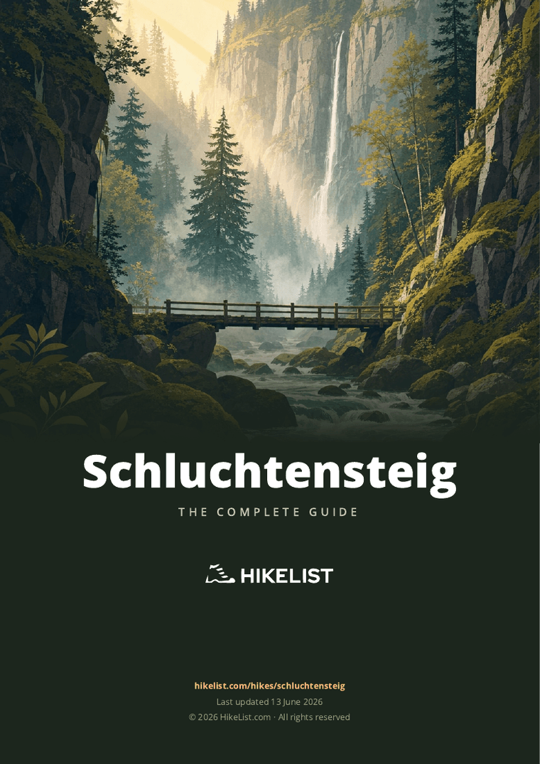
Schluchtensteig
How would you rate Schluchtensteig?
Tap a star to share your experience and help other hikers.
Schluchtensteig: Black Forest Gorge Trail Guide
HikeList Score
Schluchtensteig scored 89/100 on HikeList's trail-quality metrics.
See score breakdownHide breakdown
- Ideal length 93
- Balanced challenge 84
- Scenery & wildness 98
- Varied terrain 71
- Accommodation 83
- Food & support 88
- Path quality 98
- Season flexibility 89
Computed from length, challenge, scenery & wildness, terrain variety, accommodation, food & support, path quality and season flexibility.
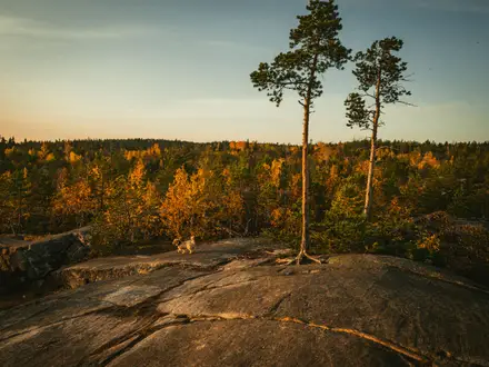
The Schluchtensteig is a 119 km waymarked point-to-point hike through the southern Black Forest in Baden-Württemberg, Germany. Usually walked in 6 days, it is officially hard: expect steep climbs in and out of ravines, narrow rocky gorge paths and exposed sections requiring sure-footedness and a head for heights. It suits fit hikers who want an inn-to-inn Black Forest route built around water — streams, waterfalls, mossy rock faces and the Wutachschlucht.
Route Overview
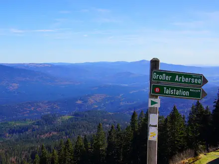
This is a one-way trail, not a loop. The usual direction is from Stühlingen on the Wutach, near the Swiss border, to Wehr at the mouth of the Wehra valley; both ends have rail/bus links. The line runs via Blumberg into the Wutachschlucht, with Schattenmühle/Wutachmühle as key gorge access points, then continues towards Lenzkirch, Schluchsee and Fischbach/Oberfischbach before reaching St. Blasien, Todtmoos and the final descent into Wehr. Follow the green Schluchtensteig diamond waymark throughout. If you are building a wider Germany hiking trip, compare Eifelsteig, Goldsteig or the Albsteig (Swabian Jura Trail).
How the Schluchtensteig Was Created
The Schluchtensteig was developed by the Schwarzwaldverein, local municipalities and Naturpark Südschwarzwald to link the southern Black Forest’s major gorges into one premium long-distance route. It was laid out and waymarked in 2007 and officially opened on 5 June 2008. The trail later gained the German Hiking Association’s quality-trail seal and joined the Top Trails of Germany network in 2012. On the route, St. Blasien grew around a Benedictine monastery first recorded in the 9th century.
Notable highlights
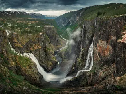
- Wutachschlucht (Wutach Gorge): The signature section of the route: a wild, undammed river canyon with cliffs, rapids and lush gorge vegetation. Lotenbachklamm and Gauchachschlucht sit nearby as side ravines.
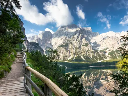
- Schluchsee (~930 m reservoir): The largest lake in the Black Forest and Baden-Württemberg, giving a broad, open-water contrast after the enclosed gorge walking.
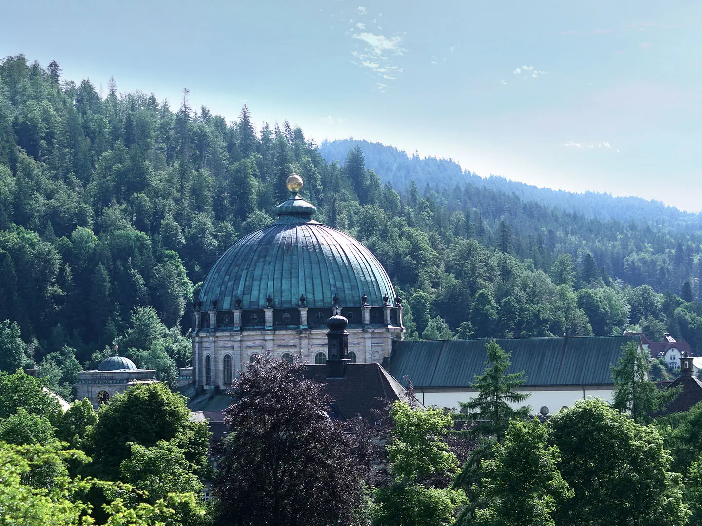
- St. Blasien Cathedral (Dom St. Blasien): A major cultural stop on the route, known for its vast early-Classical dome modelled on Rome’s Pantheon.
- Lotenbachklamm & Gauchachschlucht: Narrow side ravines off the Wutach, with footbridges, walkways and waterfalls; useful short detours if time and conditions allow.
- Windbergschlucht & Hochwehraschlucht: Further gorge sections on the western half of the trail, including the dramatic descent towards Wehr.
- Todtmoos: A high spa and pilgrimage village in forested valleys, commonly used as a late-stage rest point before the Wehra valley.
Challenges to expect
The hard rating is mainly about terrain and consistency rather than altitude. Expect 18–23 km days, steep climbs out of ravines, rocky and narrow natural paths, bridges and wooden walkways, plus exposed gorge sections where sure-footedness and a head for heights matter. Navigation is helped by the green diamond waymark, but snow makes the steep gorge paths dangerous; the route is recommended from early May to late October.
HikeList Score
Schluchtensteig scored 89/100 on HikeList's trail-quality metrics.
See score breakdownHide breakdown
- Ideal length 93
- Balanced challenge 84
- Scenery & wildness 98
- Varied terrain 71
- Accommodation 83
- Food & support 88
- Path quality 98
- Season flexibility 89
Computed from length, challenge, scenery & wildness, terrain variety, accommodation, food & support, path quality and season flexibility.
Show more data Show less
- Forest
- Mountainous
- Dirt
- Rocky
- Gravel
- Hotels
- Lodges
- Campsites
- Family Friendly
- Pet Friendly
- Restrooms
- Water Sources
- Campsites
- Shelters
- Picnic Areas
Download Our Full Guide to Schluchtensteig FREE!
Get our comprehensive guide to this hike for free. Save it for later reading or print out at home.
In these collections
Photos from hikers
Taken on the trail by people who've reviewed Schluchtensteig.
Schluchtensteig: The Complete Guide
 i
Image by P.S.DES!GN
i
Image by P.S.DES!GN The Schluchtensteig is the southern Black Forest at its most rugged: a 119 km waymarked trail from Stühlingen on the Wutach to Wehr in the Wehra valley. It suits fit hikers who want deep gorges, waterfalls, forested ridges and lake country rather than high-alpine summits.
The route builds its character in the Wutachschlucht, Lotenbachklamm and Gauchachschlucht, where narrow natural paths, bridges, wooden walkways and mossy rock walls keep the walking constantly engaging. Later stages open out towards Schluchsee, the wooded high ground around Krummenkreuz and the cultural stop of St. Blasien.
This is a hard trail because of terrain and repetition, not technical mountaineering. Expect long days of roughly 18–23 km, repeated steep climbs and descents, slippery rock and roots in wet weather, and exposed moments including the fixed 8 m ladder at the Schleifenbachfälle.
The classic six-stage itinerary links stage towns and villages with hotels, guesthouses and trail-aware hosts, making it a practical inn-to-inn walk if accommodation is booked early. Public transport via the Hochrheinbahn and local buses makes both ends reachable, though live timetable checks are essential.
This guide covers stages, daily planning, accommodation, food, transport, terrain and the common mistakes to avoid.
Stage-by-Stage Guide
Stage 1: Stühlingen to Blumberg — approx. 19 km
The Schluchtensteig starts in Stühlingen on the Wutach river, close to the Swiss border, and heads out towards Blumberg under the green-diamond Schluchtensteig waymarks. This first day is a proper introduction rather than a gentle warm-up: expect mixed valley, woodland and early gorge terrain as the route begins to follow the Wutach system towards the more enclosed sections ahead.
Underfoot, the stage combines natural paths, forest tracks, gravel and some firmer surfaces near settlements. The walking is not technical mountaineering, but the route already asks for sure-footedness where the path narrows or becomes rooty and damp.
Key places on or near this stage include Stühlingen, Weizen and Blumberg. The Wutach valley is the main landscape feature, with the sense of the trail gradually moving from open river country into steeper Black Forest terrain.
Food and water should be planned around the start and finish, with any intermediate options treated as uncertain unless checked in advance. Carry enough for the full day, especially outside peak season or if starting early.
Blumberg has accommodation options in and around the town, including the sort of hotels, guesthouses and pensions used by Schluchtensteig walkers. Booking ahead is sensible in summer and at weekends.
For public transport, Stühlingen is reached by train to Waldshut or Lauchringen, then bus line 7338 to Stühlingen. Blumberg has road access and local onward transport options, but exact bus times should be checked before travelling. Overnight guests in the Black Forest should ask their accommodation about the KONUS guest card for free local public transport.
Navigation is straightforward in normal conditions if the green diamond is followed carefully. Do not rely only on waymarks in bad weather or at junctions near settlements: carry a map or offline GPS track as a back-up.
The main warnings are wet roots, muddy natural paths and slippery rock after rain. In the official walking season this is usually a hiking stage rather than an obstacle stage, but snow, ice or storm damage can make the early gorge paths hazardous; check current route information before setting out.
Stage 2: Blumberg to Schattenmühle — approx. 20 km
This is one of the defining Schluchtensteig stages, entering the dramatic Wutachschlucht (Wutach Gorge) landscape. The walking becomes narrower, steeper and more enclosed, with cliffs, ravine vegetation, water-cut rock and repeated changes between river-level paths and higher traverses.
The Wutachflühen and the approach to the Wutach gorge give this stage a much wilder feel than the first day. Side ravines such as the Lotenbachklamm and Gauchachschlucht belong to the wider gorge system, where footbridges, walkways and waterfalls are part of the terrain rather than optional sightseeing.
The Schleifenbachfälle are the stage’s key technical feature. Reaching the cascade involves a fixed 8-metre ladder, which is a serious consideration for anyone with vertigo or who is uncomfortable using hands on exposed fixtures while carrying a pack.
Expect natural-surface paths, rock, roots, wooden structures, footbridges and potentially greasy steps. The gorge can remain damp after rain, and the steep-sided terrain means conditions may feel more committing than the map distance suggests.
Food and drink availability between Blumberg and Schattenmühle should not be assumed. Carry a full day’s food and water, and check any planned refreshment stops before leaving Blumberg.
Schattenmühle is a key stage end in the gorge area, but accommodation capacity on mid-route gorge stages can be thinner than in larger towns. Book well ahead and make clear that arrival is on foot via the Schluchtensteig.
Road access exists at Schattenmühle, but onward public transport can be limited or seasonal. This should be checked before travelling, particularly if using the stage as a day walk or bail-out point.
Navigation through the gorge relies on staying with the signed route and not improvising on informal waterside tracks. Gorge-path closures and diversions are a real planning issue on this trail because rockfall, fallen trees and weather damage can affect narrow sections; check the official current route information before walking.
Do not attempt this stage in snow or ice. The combination of steep natural paths, wet timber, rock steps and the fixed ladder makes winter or shoulder-season cold conditions disproportionately risky.
Stage 3: Schattenmühle to Oberfischbach — approx. 18 km
Stage 3 continues through the Wutach landscape before gradually shifting towards the uplands around Lenzkirch and Oberfischbach/Fischbach. It is slightly shorter than several other days, but the terrain remains demanding because of the gorge walking and repeated changes of height.
The route passes the former spa area of Bad Boll in the Wutach valley and continues towards Wutachmühle. It also passes the Stallegg power station, an important early river hydroelectric site in Baden, with the Räuberschlössle ruins nearby.
This is still a natural-path day, with riverside sections, woodland, rough ground, bridges and potentially slippery rock or roots. The gorge environment can make progress slower than a simple 18 km stage would suggest.
Lenzkirch lies on the broader line of the route before the stage finishes around Oberfischbach/Fischbach, part of the Schluchsee area. This transition is useful for planning: after the enclosed Wutach stages, the walk begins to feel more like Black Forest upland hiking.
Carry enough food and water for the day. Services may be available in larger settlements such as Lenzkirch, but opening times and exact access from the trail should be checked before relying on them.
Accommodation is normally arranged at or near Oberfischbach/Fischbach, or elsewhere in the Schluchsee area depending on availability. Because this is a hinge point between the gorge stages and the higher lake stage, early booking is advisable.
Public transport and road access are more practical around larger settlements than deep in the gorge, but exact local connections vary. Use the KONUS guest card where eligible, and check live bus times before committing to a stage-end transfer.
Navigation remains well waymarked, but the day includes enough woodland and junctions that an offline map is strongly recommended. Pay particular attention where the route leaves the immediate gorge environment and changes character towards the uplands.
The main hazards are the same as the previous stage: slippery natural surfaces, narrow paths and possible gorge-path closures. After heavy rain, allow more time and avoid rushing on wet timber or rock.
Stage 4: Oberfischbach to St. Blasien — approx. 20 km
Stage 4 is the high-level lake and upland stage of the Schluchtensteig. From Oberfischbach/Fischbach the route heads through the Schluchsee area, giving a marked change from the enclosed Wutach gorge to broader views over the largest lake in the Black Forest and Baden-Württemberg.
The route climbs onto the wooded uplands above Schluchsee, passing near Bildstein at around 1,134 m before reaching Krummenkreuz, the highest point of the entire trail at roughly 1,148 m. This is the altitude high point, but the difficulty still comes from cumulative ascent, descent and rough natural paths rather than alpine exposure.
After the high ground, the route descends towards St. Blasien via the Windbergschlucht and its waterfall. This brings gorge character back into the day, so do not treat the second half as an easy descent.
Underfoot, expect forest paths, natural tracks, roots, gravel and damp ravine sections. Conditions around the lake and higher ground can be cooler and more exposed to weather than the lower gorge stages.
Schluchsee is the major place associated with this stage and is the best-known service area on the day. Even so, carry food and water rather than assuming perfectly timed stops, especially if accommodation is not directly on the route.
St. Blasien is one of the strongest overnight stops on the trail, with hotels, guesthouses and other walker-friendly accommodation. The Dom St. Blasien is the major cultural landmark at the end of the stage and is worth allowing time for if arrival is not too late.
Road access and local public transport are generally more useful around Schluchsee and St. Blasien than in the narrower gorge sections. Exact bus and rail connections should still be checked before travelling, particularly during timetable changes.
Navigation is usually clear, but care is needed around the lake area, forest junctions and the descent through the Windbergschlucht. In poor visibility, do not rely on lake or woodland landmarks alone.
The main warnings are wet ravine paths, tired legs on the descent and changeable conditions on the high ground. Early or late in the season, snow or ice can linger on shaded upland and gorge sections, making this stage unsuitable without proper conditions.
Stage 5: St. Blasien to Todtmoos — approx. 20 km
Stage 5 crosses the Hotzenwald uplands between St. Blasien and Todtmoos. It is less dominated by a single gorge than the Wutach stages, but it remains a hard mountain-forest walking day with sustained height gain and loss.
The route passes through or near the Ibach and Dachsberg area, with high moorland scenery, forest, open clearings and the Klosterweiher pond. The Lehenkopf tower is one of the notable landmarks on this stage and provides a clear high-level focus on the way towards Todtmoos.
Terrain is typically Black Forest upland: natural paths, forest tracks, gravel, roots and damp sections around moorland. After rain, expect mud and slippery timber or rooty ground, particularly where the trail crosses shaded woodland.
The stage has a more open, upland character than the earlier gorge days, but services between the main villages should still be treated as limited. Carry a packed lunch and sufficient water unless a specific stop has been checked in advance.
Todtmoos is a practical and popular overnight stop before the final stage, with hotels, guesthouses and other accommodation in a high spa and pilgrimage village setting. Booking ahead is recommended, particularly if walking the standard six-stage itinerary.
Public transport and road access exist around Todtmoos, but local services should be checked before relying on them for arrival, departure or a shortened stage. The KONUS guest card can be valuable for walkers staying overnight in participating accommodation.
Navigation is generally simple on the signed Schluchtensteig, but moorland and forest tracks can create confusing junctions. Keep an eye on the green diamond and check the map where several tracks meet.
The main seasonal concern is poor underfoot conditions in wet weather and snow or ice outside the recommended season. The moorland and forest sections are not places to be caught without warm layers, waterproofs and navigation back-up.
Stage 6: Todtmoos to Wehr — approx. 23 km
The final stage is the longest day of the classic itinerary and should not be underestimated. It drops from the Todtmoos area through the Wehra valley system towards Wehr, finishing at the Schlosspark in the town at the foot of the valley.
The headline landscape is the Hochwehraschlucht and Wehratal, the final major gorge of the Schluchtensteig. Hirschfelsen and Pfeiferskopf are key landmarks, and the stage gives a last sustained dose of steep-sided Black Forest gorge terrain before the descent to the route’s lowest point at Wehr.
Expect a full day on forest paths, natural tracks, ravine paths, roots, rock, gravel and descending terrain. Long descents late in a multi-day walk can be hard on knees and concentration, especially with a loaded pack.
Food and water should be carried from Todtmoos. Do not assume reliable services until Wehr unless current opening times and access points have been checked.
Wehr has the route finish at the Schlosspark and offers the usual end-of-trail logistics of accommodation, food and onward travel. If staying after the walk, book ahead in busy periods rather than arriving without a plan.
For onward transport, bus line 7335 links Wehr via Wehr-Brennet / Bad Säckingen to the Hochrheinbahn at Bad Säckingen or Waldshut, then rail onward. The Hochrheinbahn is being electrified, with timetable changes and rail-replacement bus service from 26 April 2026 into summer 2027, so live times must be checked before travelling.
Navigation remains by the green diamond to the finish, but fatigue is a genuine risk on this stage. Keep checking the route at junctions in the Wehra valley and do not switch to unsigned tracks just because they appear to descend more directly.
The main warnings are distance, descent, slippery gorge paths and exposure on narrow sections. In wet weather, allow extra time; in snow or ice, the steep gorge paths are dangerous and the stage should not be attempted as a normal hiking day.
Recommended Itinerary
Standard 6-day itinerary
The classic Schluchtensteig itinerary is six walking days, with daily distances in the 18–23 km range. It suits fit, experienced hikers who are comfortable with repeated steep gorge climbs and descents rather than walkers looking for an easy inn-to-inn route.
| Day | From | To | Approx. distance | Why this stage makes sense | Services/accommodation notes |
|---|---|---|---|---|---|
| 1 | Stühlingen | Blumberg | 19 km | A logical first day from the official start on the Wutach river, building gradually towards the more demanding gorge terrain. Finishing in Blumberg keeps the opening day substantial but not excessive. | Stühlingen and Blumberg have the most straightforward start-stage logistics. Arrive the previous evening if relying on public transport connections. |
| 2 | Blumberg | Schattenmühle | 20 km | This is one of the key Wutachschlucht days, with narrow natural paths, rocky sections, side ravines and the Schleifenbachfälle ladder. Ending at Schattenmühle avoids pushing too far after the most concentrated gorge walking. | Accommodation around Schattenmühle/Wutach is thinner than in larger towns, so this is a stage to book early. If using luggage transfer or public transport, arrangements should be fixed before travelling. |
| 3 | Schattenmühle | Oberfischbach | 18 km | A shorter day on paper, but still demanding because the route continues through gorge and valley terrain before heading towards Lenzkirch and Oberfischbach/Fischbach. It keeps the transition out of the Wutach section manageable. | Services are more scattered through this middle section. Oberfischbach/Fischbach is the usual stage hinge; check the exact location of booked accommodation against the trail before committing. |
| 4 | Oberfischbach | St. Blasien | 20 km | This stage shifts from enclosed gorge country to the higher ground around Schluchsee, crosses the route’s high point near Krummenkreuz, then descends via the Windbergschlucht towards St. Blasien. | Schluchsee and St. Blasien offer more accommodation choice than the tighter gorge stages. St. Blasien is also a practical place to pause if building in a rest or recovery night. |
| 5 | St. Blasien | Todtmoos | 20 km | A sustained upland stage through the Hotzenwald, high moorland and forest, with Klosterweiher and the Lehenkopf area before reaching Todtmoos. It works well as a full walking day without leaving the final descent too long. | Todtmoos is a useful final-stage base, with accommodation suited to walkers. Book ahead in summer and check whether your accommodation participates in local guest-card transport arrangements. |
| 6 | Todtmoos | Wehr | 23 km | The longest classic stage, finishing the trail through the Wehra valley and Hochwehraschlucht before dropping to the official finish in Wehr. It is best tackled with an early start, especially in poor weather or shorter daylight. | Wehr is the finish rather than an overnight necessity, but staying there can make onward travel less rushed. From Wehr, onward bus and rail connections should be checked before travelling. |
Slower variant: 7–8 days
A slower itinerary suits hikers who want shorter walking days, extra time in the Wutachschlucht, or a recovery night after the higher stages around Schluchsee and St. Blasien. It is also sensible for anyone unsure about repeated steep descents, ladders, wet rock or narrow gorge paths.
The simplest slower plan is to keep the six walking stages but add one or two extra nights at practical stage towns such as Stühlingen, St. Blasien or Todtmoos. This reduces travel pressure and gives flexibility if weather, gorge-path conditions or fatigue become an issue.
Splitting individual stages may be possible using accommodation in or near places such as Lenzkirch, Schluchsee or the wider Wutach area, but exact distances and transport links vary by lodging location. Check official mapping and current bus times before booking any non-standard split.
Faster variant: 5 days or fewer
A faster itinerary is only suitable for very fit walkers who are already comfortable covering long, rough days on steep natural paths. The Schluchtensteig is not technically alpine, but compressing it means extending days that are already demanding because of gorge terrain, roots, rock, walkways and repeated ascent/descent.
Do not plan a compressed itinerary by distance alone. Accommodation spacing, gorge-path closures, weather and the final 23 km Todtmoos–Wehr stage all matter, and any faster schedule should be checked against official mapping before booking.
Booking notes for any itinerary
Book accommodation ahead in summer and on the thinner mid-route stages, especially around Schattenmühle/Wutach and Oberfischbach/Fischbach. Certified Steiggastgeber trail hosts are set up for Schluchtensteig walkers, but availability can still be limited.
Before fixing dates, check current trail information for gorge-path closures or diversions, particularly after storms, snow, ice or rockfall. The route is recommended from early May to late October; outside this window the steep gorge sections can be unsafe.
For public transport, check live times before travelling. The Hochrheinbahn is affected by electrification works and rail-replacement bus service from 26 April 2026 into summer 2027, which can change arrival and departure planning at both ends of the trail.
Planning the Route
How many days to allow
The Schluchtensteig is best planned as a six-stage inn-to-inn walk unless there is a strong reason to do otherwise. The classic stages are already shaped around the realistic overnight places: Stühlingen, Blumberg, Schattenmühle, Oberfischbach/Fischbach, St. Blasien, Todtmoos and Wehr.
Fit walkers can compress the route, but that makes less sense than it might on an easier forest trail. The hard work comes from repeated gorge descents and climbs, rocky natural paths, roots, wooden walkways, bridges and exposed sections, so adding distance to a day can quickly turn into a slow finish.
A slower 7–8 day plan is often more comfortable if you want more time in the Wutachschlucht, Schluchsee or St. Blasien, or if accommodation availability forces a split stage or transfer. This should be planned around confirmed beds rather than assumed from the map, especially around the gorge stages.
| Stage | Usual overnight plan | Planning notes |
|---|---|---|
| Stühlingen to Blumberg | ~19 km | A straightforward first booking pair, with rail/bus access into Stühlingen before starting. |
| Blumberg to Schattenmühle | ~20 km | Key Wutach gorge terrain; do not underestimate time on narrow and rocky paths. |
| Schattenmühle to Oberfischbach/Fischbach | ~18 km | Accommodation choice is more limited than in larger towns; book early. |
| Oberfischbach/Fischbach to St. Blasien | ~20 km | Includes the Schluchsee uplands and the high point near Krummenkreuz before descending towards St. Blasien. |
| St. Blasien to Todtmoos | ~20 km | A high Black Forest stage through the Hotzenwald and moorland scenery. |
| Todtmoos to Wehr | ~23 km | The longest classic day, finishing with the descent through the Wehra valley to Wehr. |
Book accommodation before fixing the itinerary
Accommodation is the main constraint on the Schluchtensteig. The route is walked inn-to-inn, using hotels, Gasthöfe, Pensionen, holiday apartments, some lodges and campsites in or near the stage towns.
Certified Steiggastgeber are aimed specifically at Schluchtensteig walkers and are worth checking first when building a practical schedule. Summer dates and the thinner mid-route sections around the gorge stages should be booked well ahead.
If a stage town is full, do not assume an easy on-foot alternative without checking the extra distance and public transport. A short transfer may be more sensible than turning a hard gorge stage into an overlong day.
Shortening, extending and rest days
The most natural way to make the route easier is to add a night rather than to rush. Good candidates for a slower plan are the Wutachschlucht area, Schluchsee/St. Blasien and Todtmoos, but the exact split depends on where beds are available.
Rest or transfer days can also help if weather, path conditions or fatigue make a gorge stage unwise. The route’s demanding sections are not technical mountaineering, but wet rock, mud, roots and wooden structures can slow progress significantly.
Compressing the route is only sensible for strong, sure-footed walkers who are already comfortable with consecutive 20 km-plus days on rough ground. The final Todtmoos–Wehr stage is already around 23 km, so combining stages is a serious undertaking rather than a simple fastpacking shortcut.
Section hiking
Section hiking is practical, but it needs transport planning. The start at Stühlingen is reached by train to Waldshut or Lauchringen and then bus line 7338; the finish at Wehr connects by bus line 7335 via Wehr-Brennet / Bad Säckingen to the Hochrheinbahn at Bad Säckingen or Waldshut.
Overnight guests receive the KONUS guest card, which gives free use of local buses and trains across the Black Forest. That can make it useful for skipping ahead to accommodation, returning to a base, or breaking the trail into separate weekends.
Live transport times matter here. The Hochrheinbahn is being electrified, with timetable changes and rail-replacement bus service from 26 April 2026 into summer 2027, so rail and bus connections should be checked shortly before travelling.
Food and water planning
Plan to carry lunch and snacks each day, especially through the gorge sections. The route passes towns and villages, but long stretches are forested ravines or upland paths where shops and regular food stops should not be assumed.
Start each day with enough water for the full stage, and refill at accommodation or reliable services in settlements. The route follows rivers and ravines, but streams are not a dependable drinking-water plan without treatment and should not replace carrying enough water.
Evening meals should be checked when booking accommodation. In smaller places, a bed does not automatically mean flexible meal times or nearby alternatives; this should be checked before travelling.
Navigation and route information
The Schluchtensteig is waymarked with the green diamond, but a map or offline GPX is still important. Gorge paths can be confusing where side ravines, bridges and forest tracks meet, and mobile reception should not be treated as the only navigation tool.
Before setting off, check the official current route information for closures or diversions. This matters most in the Wutachschlucht, Lotenbachklamm, Gauchachschlucht, Schleifenbachfälle and other steep ravine sections, where fallen trees, rockfall, snow or ice can make the normal path unsafe.
Weather and season planning
The route is recommended from early May to late October. Outside that window, snow, ice, fallen trees and rockfall make the steep gorge paths hazardous, and the Schluchtensteig should not be treated as a year-round lowland trail.
Wet weather also changes the character of the walk. The natural paths, roots, rocks, ladders, wooden steps and walkways can become slippery, so allow more time after rain and avoid planning tight onward transport after the harder gorge stages.
Anyone uneasy with exposure should pay particular attention to Stage 2, including the Schleifenbachfälle, where the route uses a fixed 8-metre ladder. If vertigo is a concern, this section should be considered before committing to the full itinerary.
Towns, Villages and Overnight Stops
The classic Schluchtensteig overnight pattern is Stühlingen, Blumberg, Schattenmühle, Oberfischbach/Fischbach, St. Blasien, Todtmoos and Wehr. Accommodation is a mixed inn-to-inn setup: hotels, Gasthöfe, Pensionen, holiday apartments, some lodges and campsites, plus certified Steiggastgeber trail hosts aimed at Schluchtensteig walkers.
Book ahead in summer, at weekends and on the thinner gorge-stage stops. Do not assume every small place has a shop, evening meal or late check-in; check opening days, meal times and luggage arrangements before committing.
| Place | Best use for hikers |
|---|---|
| Stühlingen | Start-night base before Stage 1 |
| Blumberg | Standard Stage 1 overnight |
| Schattenmühle | Standard Stage 2 overnight; book early |
| Oberfischbach/Fischbach | Standard Stage 3 overnight near Schluchsee |
| St. Blasien | Standard Stage 4 overnight with good recovery value |
| Todtmoos | Standard Stage 5 overnight before the long final day |
| Wehr | Finish town; useful final night if travelling onward next day |
Stühlingen
Stühlingen is the official start, on the Wutach river near the Swiss border. It is the sensible place to stay the night before walking, especially if arriving by public transport, as Stage 1 begins directly from the town towards Blumberg and the Wutach gorge.
Accommodation is available in and near Stühlingen, including the usual Black Forest mix of hotels, guesthouses and apartments. Arrange breakfast or provisions before setting off, as the first day soon leaves the start town behind.
For access, take the Hochrheinbahn to Waldshut or Lauchringen, then bus line 7338 to Stühlingen. The Hochrheinbahn is being electrified, with timetable changes and rail-replacement bus service from 26 April 2026 into summer 2027, so live rail and bus times should be checked before travelling.
Weizen
Weizen comes early on Stage 1 between Stühlingen and Blumberg. It is more useful as a route point than as a main overnight base for the standard six-day itinerary.
It may suit walkers splitting the first stage, but accommodation and food options should be checked before travelling. Do not rely on finding a full range of services here without a booking.
Blumberg
Blumberg is the standard end of Stage 1 and start of Stage 2. It is one of the key practical overnight stops on the route, giving a firm base before the more committing gorge walking towards Schattenmühle.
Hotels, guesthouses and other walker-friendly accommodation are available in and near the town. This is a good place to organise an evening meal and any next-day food, as Stage 2 includes narrow ravines, waterfalls and natural gorge paths where services are limited and opening times matter.
Public transport options in this part of the southern Black Forest vary by day and season. Use the KONUS guest card where issued by accommodation, but check the exact bus times before travelling or section-hiking.
Wutachschlucht
The Wutachschlucht, or Wutach Gorge, is not a conventional overnight stop but the main terrain zone of the early route. The trail passes through and around the gorge over the opening stages, with cliffs, footbridges, rocky natural paths and steep climbs in and out of side ravines.
Plan this section as a carry-what-you-need day rather than a casual village-to-village stroll. Food, water, waterproofs and enough daylight are important, and current gorge-path closures or diversions should be checked before setting off.
Schattenmühle
Schattenmühle is the classic Stage 2 overnight stop after the Wutach gorge section from Blumberg. It is one of the places where advance booking matters most, because the mid-route gorge stages have fewer easy fallback options than the larger towns.
Accommodation is available at or near the stage stop, but capacity can be limited. Check whether an evening meal and breakfast are available at the accommodation, and do not assume there will be a shop nearby.
Schattenmühle also works as a useful decision point for weather and trail conditions. If gorge paths are wet, icy or affected by fallen trees or rockfall, seek local advice and check official route information before continuing.
Bad Boll (Wutach)
Bad Boll is a route point in the Wutach area on the way towards Wutachmühle and Lenzkirch. Treat it as a useful waypoint within the gorge landscape, not as a guaranteed full-service overnight base.
Any accommodation, food or refreshment plans here should be arranged in advance. For most six-day walkers, Bad Boll is passed during the walking day rather than used as the night stop.
Wutachmühle
Wutachmühle sits later in the Wutach section before the route continues towards Lenzkirch and Oberfischbach/Fischbach. Like Bad Boll, it is important for navigation and pacing but should not be assumed to provide comprehensive services.
If planning a shortened or altered stage around Wutachmühle, check accommodation, meals and public transport before travelling. Carry enough food for the day regardless, as gorge-stage refreshment options are not as dependable as town services.
Lenzkirch
Lenzkirch lies on the Stage 3 line between Schattenmühle and the Oberfischbach/Fischbach area. It can be useful for services or as an alternative overnight if adjusting the standard itinerary.
Accommodation exists in and near Lenzkirch, but choosing it as a night stop changes the rhythm of the classic six-stage schedule. Check how the next day’s distance and ascent work out before booking, especially if aiming to continue over Schluchsee and the high ground towards St. Blasien.
Oberfischbach / Fischbach
Oberfischbach/Fischbach is the usual Stage 3 overnight, forming the hinge between the Wutach/Lenzkirch section and the Schluchsee–St. Blasien stage. It is part of the Schluchsee municipality area and is often listed under either Fischbach or Oberfischbach, so use the exact accommodation address when booking.
This is a good practical stop, but village-scale rather than a large town. Book a bed and evening meal in advance, and check breakfast timing if making an early start towards Schluchsee, Bildstein, Krummenkreuz and St. Blasien.
Schluchsee
Schluchsee is reached on Stage 4 and provides the route’s main lake setting after the enclosed gorge terrain. The wider Schluchsee area has accommodation, including hotels, guesthouses and holiday apartments, and can work as a useful alternative stopping area if the standard Oberfischbach/Fischbach to St. Blasien stage is being adjusted.
Because the route continues over the high ground towards Krummenkreuz before descending to St. Blasien, stopping at Schluchsee changes the following day’s workload. Check the exact location of accommodation against the trail line, as “Schluchsee” can refer to the wider lake area as well as the settlement.
St. Blasien
St. Blasien is the standard Stage 4 overnight and one of the most useful recovery stops on the Schluchtensteig. It sits after the Schluchsee high ground and the descent through the Windbergschlucht area, making it a logical place for a proper meal, laundry if available, and a less rushed evening.
There is accommodation in and near St. Blasien, including the normal hotel and guesthouse options. The Dom St. Blasien is the main cultural landmark, but for walkers the practical advantage is simply that this is a more substantial overnight stop than the smaller upland villages.
Check onward transport locally if section-hiking from here. KONUS may help with regional buses and trains when issued by accommodation, but exact connections should be checked before travelling.
Ibach / Dachsberg area
The Ibach and Dachsberg area lies between St. Blasien and Todtmoos, across the Hotzenwald high moorland section. It is better understood as an upland area of scattered settlements and route points than as one single obvious stage town.
It can be used to shorten or reshape Stage 5, but only with accommodation arranged in advance. Food, evening meals and transport should also be checked before booking, as services are less straightforward than in St. Blasien or Todtmoos.
Todtmoos
Todtmoos is the classic Stage 5 overnight and a strong strategic stop before the final, longer stage to Wehr. It is a high spa and pilgrimage village set among forested valleys, with accommodation available in and near the village.
This is the place to prepare for the final 23 km day through the Wehratal and Hochwehraschlucht. Arrange breakfast, carry sufficient food, and check the weather, as the last day still includes demanding gorge-and-valley terrain before the descent to Wehr.
Todtmoos is also a sensible place to add a rest or easier day if walking the Schluchtensteig over more than six days. If using public transport for access or departure, check current bus times before travelling.
Wehratal / Wehra valley
The Wehratal is the final valley and gorge section of the route rather than a normal overnight base. The Schluchtensteig descends through the Hochwehraschlucht/Wehra valley area, passing dramatic terrain including the Hirschfelsen and Pfeiferskopf before reaching Wehr.
Treat this as a committed final walking section. Start from Todtmoos with enough food, water and time, and do not rely on services until the finish unless specific stops have been checked in advance.
Wehr
Wehr is the official finish, at the Schlosspark in the town at the foot of the Wehra valley. It is the lowest point of the route and a practical place to end the walk, eat, stay overnight or connect onward by public transport.
Accommodation is available in and near Wehr, which is useful if finishing late after the long final stage from Todtmoos. Staying here also removes pressure from same-day onward travel.
For public transport, bus line 7335 links Wehr via Wehr-Brennet / Bad Säckingen to the Hochrheinbahn at Bad Säckingen or Waldshut. Basel is the nearest major hub/airport, and live times should be checked carefully, especially during the Hochrheinbahn electrification works and rail-replacement periods.
Getting to the Start
By train
Stühlingen is reached most easily by combining the Hochrheinbahn with a local bus. The practical rail approach is to travel on the Basel–Waldshut–Schaffhausen–Konstanz corridor, then change for the bus to Stühlingen.
For most international and long-distance journeys, Basel is the main gateway. From Basel, take the Hochrheinbahn towards Waldshut or Lauchringen, then continue by local bus to Stühlingen.
Allow extra time for connections, especially if arriving late in the day before Stage 1. The Hochrheinbahn is being electrified, with timetable changes and rail-replacement buses (Schienenersatzverkehr) from 26 April 2026 into summer 2027. This should be checked before travelling.
By bus
The key local connection for the start is bus line 7338 from Waldshut or Lauchringen to Stühlingen. This is the standard public-transport link between the Hochrheinbahn and the official start town.
Check the current timetable carefully, particularly at weekends, on public holidays and outside the main walking season. If a missed connection would prevent starting the next morning, consider arriving in Stühlingen the previous afternoon rather than relying on an evening transfer.
Overnight guests in the Black Forest usually receive the KONUS guest card, which gives free use of local buses and trains across the Black Forest. It is useful for onward and local movements during a Schluchtensteig trip, but the exact validity for a planned journey should be checked before travelling.
By car
Driving to Stühlingen is possible, but the Schluchtensteig is a point-to-point trail ending in Wehr, not a loop. Leaving a car at the start means arranging a return journey from Wehr by bus and rail after the final stage, which can add a significant transport leg at the end of the walk.
Long-stay parking arrangements in Stühlingen should not be assumed. Ask your accommodation or the local tourist information where multi-day parking is permitted, and whether any restrictions apply. This should be checked before travelling.
If public transport connections are limited at the time you arrive, a local taxi may be useful for the final leg from a railhead such as Waldshut or Lauchringen. Taxi availability and fares should be arranged in advance rather than left until late evening.
From the nearest airport
Basel is the nearest major airport and transport hub for the Schluchtensteig. From Basel, continue by rail on the Hochrheinbahn towards Waldshut or Lauchringen, then take bus line 7338 to Stühlingen.
Because the route to the start depends on a train-to-bus connection, flight arrival time matters. For a less pressured first day, it is usually more practical to fly in and sleep in Stühlingen before starting the walk, rather than trying to land, transfer and begin Stage 1 on the same day.
Where to stay before starting
Stühlingen is the best place to stay before Stage 1, as it is the official start town on the Wutach river and avoids needing a morning transfer before the first 19 km stage to Blumberg. Accommodation is typically in small hotels, guesthouses, inns and holiday apartments.
Book ahead in summer and during busy holiday periods. If staying with a Schluchtensteig trail host or other local accommodation, ask in advance about breakfast times, packed lunches, luggage arrangements if using a transfer service, and where the green-diamond waymark is most conveniently joined from the property.
Getting Home from the Finish
By train
The Schluchtensteig finishes in Wehr at the Schlosspark, but the practical rail exit is via the Hochrheinbahn, the railway running along the Rhine corridor between Basel, Waldshut, Schaffhausen and Konstanz.
From Wehr, plan on taking a local bus first, then joining the railway at Bad Säckingen or Waldshut. Basel is the most useful larger onward hub for international rail and air connections.
A key planning point is the Hochrheinbahn electrification work: from 26 April 2026 into summer 2027, timetable changes and rail-replacement bus services (Schienenersatzverkehr) affect this corridor. Check live connections before booking fixed onward trains or flights.
By bus
Bus line 7335 is the main public-transport link from Wehr towards Wehr-Brennet / Bad Säckingen and Waldshut, where onward rail connections are available.
Because the final stage from Todtmoos to Wehr is a long walking day, do not assume there will be a convenient late connection after arrival. Check the last bus from Wehr before starting the final stage, especially at weekends, on public holidays or if walking outside the main summer period.
Overnight guests in the Black Forest receive the KONUS guest card, which gives free use of local buses and trains across the Black Forest area. It can be useful for the exit journey, but the exact validity for the connection needed should be checked before travelling.
By car/taxi
For walkers who left a car at the start in Stühlingen, the return from Wehr is a cross-country public-transport journey rather than a simple shuttle. The usual approach is to leave Wehr by bus to the Hochrheinbahn, travel by rail towards Waldshut or Lauchringen, then use bus line 7338 to reach Stühlingen.
A taxi can simplify the first leg from Wehr to a rail station, or act as a fallback if the final bus has been missed. Availability and cost should be checked before travelling, and pre-booking is sensible if finishing late in the day.
From the nearest airport
Basel is the nearest major hub and airport for the route. From Wehr, travel by bus to the Hochrheinbahn at Bad Säckingen or Waldshut, then continue by rail towards Basel.
Allow extra time for the bus-to-train connection and for any Hochrheinbahn engineering works. During the 2026–2027 electrification period, avoid tight flight connections unless live timetables clearly support them.
Where to stay at the finish
Wehr has accommodation options in and around the town, including hotels, guesthouses and holiday apartments used by Schluchtensteig walkers. Staying overnight at the finish is often the simplest option if the final stage has taken longer than expected or if onward travel involves Basel, Waldshut, Schaffhausen or Konstanz.
Booking ahead is advisable in the main walking season. An overnight stop also gives more flexibility if rail-replacement buses or revised Hochrheinbahn timetables make same-day onward travel awkward.
Which Direction Should You Walk?
The Schluchtensteig is normally walked east to west, from Stühlingen to Wehr. This is the official and classic direction of the six-stage itinerary, following the green-diamond Schluchtensteig waymark out from Stühlingen towards Blumberg, through the Wutachschlucht and across the southern Black Forest to the finish in Wehr’s Schlosspark.
Walking it in reverse is possible in principle, but it is less natural for most independent hikers. The stage structure, holiday packages and much of the accommodation flow are built around the standard Stühlingen → Wehr direction.
Standard direction: Stühlingen to Wehr
This is the best direction for most walkers. It gives the route its intended progression: the Wutachschlucht and its side ravines come early, the landscape then opens out around Schluchsee and the high ground near Krummenkreuz, before the route finishes with the long drop through the Wehra valley into Wehr.
It also makes psychological sense. Wehr is the lowest point of the route, so the final day from Todtmoos ends with a clear descent towards the finish rather than a hard climb away from it. The last stage is still long and demanding, but it feels like a proper end to a point-to-point crossing.
The total ascent in the standard direction is about 3,180 m, with slightly more descent overall. Reversing the route would add a little more climbing, but the difference is not large enough to be the deciding factor; the real difficulty is the repeated steep gorge terrain, not the overall elevation total.
Transport is workable at both ends. For the standard direction, hikers usually reach Stühlingen by train to Waldshut or Lauchringen, then bus line 7338. From Wehr, bus line 7335 connects via Wehr-Brennet / Bad Säckingen to the Hochrheinbahn at Bad Säckingen or Waldshut. Live rail and bus times should be checked before travelling, especially during the Hochrheinbahn electrification works and rail-replacement bus period from 26 April 2026 into summer 2027.
Reverse direction: Wehr to Stühlingen
The reverse direction can suit walkers with fixed accommodation availability, a specific transport plan, or a desire to save the Wutachschlucht for the end. It turns the classic finish into an opening climb from the low Wehra valley, which is a tougher way to begin the trail.
The scenery progression also changes. Instead of building from the Wutach gorge to lakes, uplands and the final Wehra descent, the route begins with the Hochwehraschlucht / Wehratal and works back towards the Wutach valley. That can be appealing, but it loses the traditional sense of crossing the route towards a clear lowland finish.
Accommodation needs more care in reverse. The same towns and villages can be used, but many walkers, hosts and luggage-transfer arrangements are geared to the standard six-stage order. Book every night before committing, particularly around the thinner mid-route gorge stages such as Schattenmühle and the Wutach area.
Weather, waymarking and practicalities
There is no strong direction choice based on prevailing wind or weather. The more important issue is underfoot condition: gorge paths, wooden walkways, roots and rocky steps can be slippery after rain, and the route is discouraged from November to early May because snow, ice, fallen trees and rockfall make the steep gorge sections hazardous.
Direction does not remove the need for sure-footedness. The Schleifenbachfälle ladder, narrow gorge paths and exposed sections are demanding whichever way they are walked.
Recommendation
Walk the Schluchtensteig in the standard Stühlingen → Wehr direction unless there is a specific accommodation or transport reason to reverse it. It follows the official stage rhythm, gives the best landscape progression, avoids starting with the climb out of the Wehra valley, and finishes naturally with the descent into Wehr’s Schlosspark.
Accommodation Along the Route
The Schluchtensteig works well as an inn-to-inn walk, but it is not a route where every stage has a large choice of beds directly on the trail. The strongest accommodation bases are the established towns and resort villages: Stühlingen, Blumberg, Schluchsee, St. Blasien, Todtmoos and Wehr. The more awkward nights are around the Wutach Gorge and the Oberfischbach/Fischbach area, where choice is thinner and early booking matters.
Most walkers follow the classic six-stage pattern, staying in Stühlingen before the start, then Blumberg, Schattenmühle, Oberfischbach/Fischbach, St. Blasien, Todtmoos and Wehr. Hotels, Gasthöfe, Pensionen and holiday apartments are the normal accommodation mix, with some lodges and campsites in and near the route towns. Certified Steiggastgeber trail hosts are especially useful because they are geared towards Schluchtensteig walkers.
Where to stay
| Place | Accommodation level | Best for | Notes |
|---|---|---|---|
| Stühlingen | Good | Pre-walk night and official start | Sensible place to stay before Stage 1 so the first day to Blumberg can start early. |
| Weizen | Limited | Possible stop or service point near Stage 1 | Not a standard overnight on the six-stage itinerary. Availability should be checked before planning a shorter first day. |
| Blumberg | Good | Stage 1 overnight | One of the more practical stage towns, with better options than the gorge sections that follow. |
| Wutachschlucht / Wutach Gorge | None to very limited on the gorge section itself | Walking section, not a dependable accommodation base | Do not rely on finding a bed inside the gorge. Plan the night around Blumberg, Schattenmühle or nearby settlements instead. |
| Schattenmühle / Wutach area | Limited | Stage 2 overnight | This is one of the key bottlenecks. Book early, especially in summer and at weekends, or arrange a transfer to accommodation nearby. |
| Wutachmühle / Bad Boll area | Limited | Possible transfer or alternative planning point | Useful as a route reference in the Wutach area, but not a strong accommodation base for independent walkers. This should be checked before travelling. |
| Lenzkirch | Good | Alternative base around the Stage 3/4 transition | A practical option if beds around Oberfischbach/Fischbach are limited, though transfers or public transport may be needed depending on the exact accommodation. |
| Oberfischbach / Fischbach | Limited | Stage 3 overnight on the classic itinerary | The standard hinge between Stages 3 and 4, but with less choice than the larger towns. Reserve well ahead. |
| Schluchsee | Good | Alternative overnight or rest/short-stage base | One of the stronger accommodation areas on the route, useful if stretching the walk beyond six days. |
| St. Blasien | Good | Stage 4 overnight | A strong and practical overnight stop with services, and a natural place to reset after the higher ground around Schluchsee. |
| Ibach / Dachsberg area | Limited | Possible intermediate or transfer-based stop | Useful for walkers breaking up the St. Blasien–Todtmoos stage, but availability is not as broad as in the main towns. This should be checked before travelling. |
| Todtmoos | Good | Stage 5 overnight or late-route rest point | A high spa and pilgrimage village and one of the better places to pause before the final long descent to Wehr. |
| Wehratal / Hochwehraschlucht | None to very limited on the gorge section itself | Final walking section | Treat this as route terrain rather than an accommodation base. Plan to finish in Wehr or arrange onward transport. |
| Wehr | Good | Finish night and onward travel | Practical for the final night after the long Todtmoos–Wehr stage, particularly if onward transport is the next day. |
Booking strategy
Book accommodation before starting the trail rather than trying to improvise each day. This is particularly important from early May to late October, and especially in summer, on weekends and around the Wutach Gorge stages.
The most sensitive nights are usually Schattenmühle / Wutach and Oberfischbach / Fischbach. If those are full, look at nearby bases such as Lenzkirch or Schluchsee and arrange a transfer, taxi or public-transport link before committing to the booking.
For the larger stops — Stühlingen, Blumberg, Schluchsee, St. Blasien, Todtmoos and Wehr — there is generally more flexibility, but advance booking is still recommended for a fixed six-day itinerary. A missed bed on this route can force a long detour or an extra transfer, because the gorge terrain limits easy escape options.
Transfers, luggage and awkward gaps
The Schluchtensteig is very suitable for inn-to-inn walkers carrying their own overnight kit. Those wanting lighter packs should look at walking-holiday operators, some of which offer 7–8 day versions of the route with rest or transfer days. Confirm whether luggage transfer is included before booking.
Independent hikers should not assume luggage transfer is available between every small stop. If using taxis or accommodation transfers to solve a full stage village, agree the pickup point, time and price in advance.
Overnight guests receive the KONUS guest card, which gives free use of local buses and trains across the Black Forest. This can help with accommodation slightly off the exact line, but live times should always be checked before relying on it, particularly where a bus link is needed at the start or end of a walking day.
Camping and Wild Camping
Camping is possible on the Schluchtensteig only with planning. The route is primarily set up as an inn-to-inn walk, with hotels, Gasthöfe, Pensionen, holiday apartments, some lodges and some campsites in or near the stage towns. Do not assume that every overnight stop has a convenient campsite directly on the trail.
Campsites and practical camping options
The most realistic approach is to plan camping around the main settlements and service points: Stühlingen, Blumberg, the Lenzkirch / Oberfischbach / Fischbach area, Schluchsee, St. Blasien, Todtmoos and Wehr. Availability, exact locations, opening dates and whether tents are accepted should be checked before travelling.
The thinner mid-route gorge stages need particular care. Around the Wutachschlucht and Schattenmühle area, accommodation should be booked ahead rather than treated as a place where camping can be improvised at the end of a long day.
Because the classic stages are 18–23 km and the terrain is repeatedly steep, camping adds a real physical burden. A heavy pack is awkward on narrow rocky gorge paths, wooden walkways, rooty descents and the fixed 8 m ladder at the Schleifenbachfälle. If camping, keep the load compact and avoid strapping loose items outside the pack.
Wild camping
Do not plan the Schluchtensteig as a wild-camping route. The trail runs through the Naturpark Südschwarzwald, forested gorges, villages, farmland edges and areas where land ownership and local restrictions vary. Wild camping rules must be checked locally, and permission should be obtained where required.
Sleeping discreetly without permission is not a reliable or responsible plan here. The gorge sections are sensitive, narrow and often steep, with limited flat ground and high visitor pressure in good weather. Campfires should not be made unless a site specifically permits them; in dry forest conditions, fire risk is a serious concern.
Water and supplies for campers
The route follows or crosses rivers, ravines, waterfalls and Schluchsee, but that does not mean drinking water is automatically available or safe. Plan to refill in towns, booked accommodation, campsites or recognised services rather than relying on untreated river or lake water.
Carry enough water for the longer gorge and upland stretches, especially in warm weather. Natural water should be treated if used, and local restrictions should be respected.
Best use of a tent on this route
Camping suits hikers who are already comfortable with lightweight multi-day walking and who have pre-booked legal places to pitch. It is less suitable for walkers hoping to keep the itinerary flexible by camping wherever the day ends.
A mixed plan often works better: use campsites where they fit the itinerary, and use guesthouses or trail hosts on the tighter or more demanding stages. This reduces pack weight through the most awkward gorge terrain and avoids being forced into a long detour at the end of the day.
Leave No Trace on the Schluchtensteig
Keep impact low: pitch only where permitted, pack out all litter, avoid damaging vegetation, and keep well away from watercourses when washing or toileting. The Wutachschlucht, side ravines and Hochwehraschlucht are the wrong places for improvised camping.
Stick to the waymarked path in the gorges, especially after rain, and do not cut corners on steep banks. The same caution applies in shoulder season: from November to early May the route is discouraged because snow, ice, fallen trees and rockfall make the steep gorge paths hazardous, and camping conditions are correspondingly poor.
Food, Water and Resupply
The Schluchtensteig is an inn-to-inn route, not a wilderness trail, but food planning still matters. The harder days pass through gorges, forest and upland areas where there may be long stretches without shops or reliable catering, especially between Blumberg, Schattenmühle and Oberfischbach/Fischbach.
Plan each stage around breakfast at your accommodation, a packed lunch, and an evening meal in the stage village or town. Certified trail hosts and local guesthouses are used to walkers, but packed lunches, early breakfasts and evening meals should be requested when booking rather than assumed on arrival.
Food availability
The easiest places to resupply are the main stage settlements: Stühlingen, Blumberg, Schluchsee, St. Blasien, Todtmoos and Wehr. Smaller overnight points such as Schattenmühle and Oberfischbach/Fischbach are more limited, and food there should be treated as accommodation-based unless you have checked current options.
Shops in rural Germany often have limited hours, and many close on Sundays and public holidays. Restaurants, cafés and Gasthöfe can also have rest days or seasonal opening patterns. This should be checked before travelling, particularly if a stage ends in a smaller village or if walking outside the main summer holiday period.
Carry lunch and snacks every day. On the gorge stages, do not rely on being able to buy food en route: terrain and opening hours make a planned picnic much safer than hoping for a café at the right time.
Water availability
Refill from accommodation, cafés, restaurants and public facilities where available in villages and towns. Start each day with enough water for the full stage unless a known refill has been arranged.
The route follows rivers, ravines and Schluchsee, so water is visually abundant, but natural water should not be treated as automatically safe to drink. If using river, stream or lake water, filter or treat it first; gorge water can be affected by upstream paths, settlements, livestock or heavy rain runoff.
For typical conditions, 1.5–2 litres is a sensible starting amount for most walkers, with more needed in hot weather, for faster dehydration on steep climbs, or on the longer final stage to Wehr. In cool, wet conditions some walkers will carry less, but the safest approach is to leave each morning self-sufficient.
| Section | Food availability | Water availability | Notes |
|---|---|---|---|
| Stühlingen → Blumberg | Best planned from Stühlingen before setting out, with food again in Blumberg. Do not depend on frequent on-trail resupply. | Refill before leaving Stühlingen and again in Blumberg. Natural water should be treated if used. | Carry lunch and snacks from the start. |
| Blumberg → Schattenmühle | Limited once committed to the Wutachschlucht area; arrange food in Blumberg and confirm evening meal arrangements at Schattenmühle. | Start with enough for the day. Rivers and streams are present but should be filtered or treated. | One of the key stages for carrying a proper packed lunch. |
| Schattenmühle → Oberfischbach/Fischbach | Limited mid-stage food options; rely on breakfast/packed lunch from accommodation and food at the overnight stop. | Refill at accommodation before departure. Treat natural water if needed. | Check arrangements carefully if staying in a small guesthouse or holiday apartment. |
| Oberfischbach/Fischbach → St. Blasien | Better resupply opportunities around Schluchsee and St. Blasien, but opening hours still matter. | Refill at the start and in settlements. Do not drink untreated lake or stream water. | A more forgiving stage for services than the deep gorge sections, but still carry lunch. |
| St. Blasien → Todtmoos | Good planning point at St. Blasien; food again at Todtmoos. On-trail options across the Hotzenwald uplands should not be assumed. | Fill up in St. Blasien. Carry enough across the upland and moorland sections. | Check Todtmoos evening meal options when booking accommodation. |
| Todtmoos → Wehr | Start from Todtmoos with a full day’s food; resupply is mainly at the finish in Wehr. | Carry enough water for the long final stage, especially in warm weather. Treat any natural water used in the Wehra valley. | At about 23 km, this is the longest classic stage, so snacks and water margins matter. |
Terrain, Conditions and Difficulty in Practice
The Schluchtensteig is difficult because of terrain, repetition and exposure rather than high altitude. The route never becomes via-ferrata mountaineering, but it asks for confident feet over six consecutive days of steep gorge paths, rocky natural tracks, roots, bridges, wooden walkways and long climbs out of ravines.
Only about 16% of the trail is paved, and more than half is on natural-surface path. Expect dirt, rock, gravel, tree roots, wooden steps, footbridges and sections where wet leaves or mossy stone can make secure footing more important than speed.
Underfoot: what the walking feels like
The defining terrain is forested gorge walking. In the Wutachschlucht, Lotenbachklamm, Gauchachschlucht, Windbergschlucht and Hochwehraschlucht / Wehratal, the path is often narrow, enclosed and uneven, with damp rock faces, steep wooded slopes and water close by.
Between the gorges, the route uses forest tracks, natural paths over wooded ridges and higher Black Forest upland around Schluchsee, Krummenkreuz and the Hotzenwald. These linking sections are generally less technical, but they still add distance and ascent after the more concentrated gorge terrain.
Road walking is not a major feature of the route. There are paved sections and village approaches, but the practical character of the Schluchtensteig is overwhelmingly trail-based rather than tarmac-based.
Climbs, descents and accumulated fatigue
The route climbs roughly 3,180 m in total, with about 3,290 m of descent. None of the individual heights are alpine — the high point at Krummenkreuz is around 1,148 m — but the repeated drops into ravines and climbs back to forest or upland level make the days feel harder than the map distance alone suggests.
The classic stages are mostly around 18–23 km. Fit walkers may find the daily distances manageable in dry conditions, but the same stages become much slower when gorge paths are wet, leaf-covered or busy.
The final stage from Todtmoos to Wehr is the longest of the classic itinerary at about 23 km and includes the descent through the Wehra valley to the lowest point of the route. It should not be treated as an easy run-in simply because it finishes downhill.
Exposure, ladders and narrow gorge paths
The most obvious obstacle is the fixed 8 m ladder at the Schleifenbachfälle on Stage 2. It is short, but it is exposed enough to matter for anyone uncomfortable with heights, ladders or descending on metal rungs with a pack.
Elsewhere, the exposure is more sustained than dramatic: narrow natural paths above water, steep-sided ravines, rocky traverses, wooden walkways and bridges. These sections are not technical climbing, but they require concentration and sure-footedness.
Walkers with vertigo should take the difficulty rating seriously. The trail is well waymarked, but waymarking does not remove the need for a steady head on the gorge sections.
Wet, mud, snow and seasonal hazards
The Schluchtensteig is recommended from early May to late October. Outside that window, snow, ice, fallen trees and rockfall make the steep gorge paths hazardous, and November to early May is discouraged.
Wet weather has an immediate effect on difficulty. Rock, roots, wooden steps and mossy surfaces in the gorges can become slippery, and shaded ravines may stay damp long after rain has stopped.
Mud is most likely to be a practical nuisance on natural forest paths and higher moorland sections, including the Hotzenwald high moorland on Stage 5. Waterproof footwear with a grippy sole is more useful here than lightweight road-style shoes.
Before setting off, check current official path information for gorge closures and diversions. The narrow ravine sections are exactly the type of terrain where storm damage, fallen trees or rockfall can change the day’s walking.
Weather and Best Time to Walk
The practical walking season for the Schluchtensteig is early May to late October. Outside this window the route is not a sensible winter objective: snow, ice, fallen trees and rockfall can make the steep gorge paths hazardous, especially in the Wutachschlucht, side ravines and the Hochwehraschlucht.
For most hikers, the best balance is late spring to early autumn, when the gorge paths are usually usable and the classic six-stage itinerary has enough daylight for sustained 18–23 km days. Summer is the easiest period for logistics, but accommodation should be booked ahead, particularly around the thinner mid-route stages near the gorge sections.
Month-by-month planning
| Period | What to expect | Planning advice |
|---|---|---|
| Early May | Start of the recommended season, but the route may still be affected by winter damage in the gorges. | Check the official aktuelle Weginfos for closures or diversions before travelling. Be cautious on wet rock, roots, wooden steps and bridges. |
| Late May–June | A strong choice for most walkers: long enough days and generally practical conditions for gorge walking. | Still plan for wet, slippery surfaces in shaded ravines. Book accommodation in advance rather than assuming space in small stage villages. |
| July–August | Main summer walking season, with the most reliable logistics but higher accommodation demand. | Reserve beds early. In hot weather, the repeated climbs out of the ravines are strenuous, so start promptly and carry enough water between services. |
| September | Often one of the most practical months: still within the normal season, with less pressure than high summer in many places. | Daylight begins to shorten, so avoid late starts on the longer stages, especially Todtmoos to Wehr. |
| October | Still within the recommended season, but more marginal: shorter days, colder starts and wetter surfaces can all matter. | Treat the gorge sections conservatively. Check current path information and allow enough time to finish before dusk. |
| November–early May | Not recommended. Snow, ice, rockfall and fallen trees make the steep natural paths unsafe. | Do not plan the Schluchtensteig as a winter through-hike. |
Rain, slippery ground and gorge conditions
Wet weather matters more on this trail than altitude. Over half the route is on natural-surface paths, with dirt, rock, roots, gravel, wooden walkways, steps and footbridges; these become slippery quickly in rain or lingering damp.
The most consequential sections are the narrow gorge and ravine paths: the Wutachschlucht, Lotenbachklamm, Gauchachschlucht, Windbergschlucht and Hochwehraschlucht. After heavy rain, expect slower progress and a higher need for sure-footedness, even where the waymarking remains clear.
The 8 m fixed ladder at the Schleifenbachfälle is also more serious in poor conditions. Walkers uneasy with exposure should not treat it as a bad-weather obstacle to “push through”.
Snow, ice and winter realism
The Schluchtensteig reaches about 1,148 m at Krummenkreuz above Schluchsee, but the winter problem is not high-alpine altitude. The danger is the combination of steep gorge terrain, narrow natural paths, wooden structures, rock, roots and ice.
For this reason, the route is discouraged from November to early May. Even short icy patches can make exposed ravine paths unsafe, and fallen trees or rockfall can force diversions. Current route information should be checked before any early- or late-season trip.
Daylight and stage timing
The classic itinerary has long walking days of roughly 18–23 km, with repeated climbs and descents that slow progress. In May through August, daylight is usually generous enough for steady walkers, but October trips need more disciplined starts.
The final stage from Todtmoos to Wehr is the longest of the classic stages and includes the descent through the Wehra valley. In short-day conditions, leave enough margin for rough or slippery ground and do not rely on finishing the gorge sections at dusk.
Accommodation and seasonal demand
The route is built around inns, guesthouses, hotels, holiday apartments and trail-friendly hosts in and near the stage towns, but capacity is not unlimited. Summer and the thinner mid-route gorge stages should be booked ahead, especially if following the standard six-stage schedule.
Outside the recommended walking season, the main issue is not just accommodation availability but trail safety. A winter booking does not make the gorge paths suitable for a through-hike.
Safety Notes
The Schluchtensteig is a well-waymarked hiking route, not a mountaineering route, but its risks are real: steep ravine paths, wet rock, wooden walkways, bridges, narrow natural tread and repeated climbs and descents. The most important safety judgement is knowing when gorge conditions are unsuitable and using the official diversion or transport option instead of forcing the stage.
Emergency help and communication
The emergency number in Germany is 112 for fire and ambulance services. Mobile reception should not be relied on in the deeper gorges, ravines and forested valleys, especially through the Wutachschlucht, side Klammen and the Wehratal.
Carry an offline map or downloaded GPX track as well as the green-diamond waymarking. A paper map is sensible for anyone walking solo or outside peak summer, as a flat battery or poor signal can quickly become a problem in wooded gorge terrain.
Gorge paths, ladders and exposure
The main safety hazards are concentrated on the narrow gorge sections: the Wutachschlucht, Lotenbachklamm, Gauchachschlucht, Windbergschlucht and the Hochwehraschlucht / Wehratal. Expect damp rock, roots, wooden steps, footbridges and short exposed sections where a slip would matter.
The Schleifenbachfälle section includes a fixed 8-metre ladder. Walkers with vertigo, poor balance or a heavy pack should treat this as a serious obstacle, not a novelty. In wet conditions, take extra time and keep both hands free on ladders, railings and steep steps.
Weather, snow and seasonal conditions
The recommended walking season is early May to late October. Outside this window, snow, ice, fallen trees and rockfall make the steep gorge paths hazardous, and winter walking on this route is strongly discouraged.
Even within the main season, conditions can vary sharply. Gorges can stay cold, damp and slippery after rain, while open sections around Schluchsee, Krummenkreuz and the Hotzenwald high ground can be exposed to wind, sun or sudden temperature drops. Pack waterproofs and a warm layer even on a fine forecast.
After heavy rain, treat ravine paths, waterfalls, bridges and river-edge sections with caution. Do not step beyond barriers or leave the marked path to approach rapids, waterfalls or unstable gorge edges.
Heat, cold and water
Long stages of roughly 18–23 km make heat management important in summer. Start early in hot weather, carry enough water between villages and avoid assuming that every gorge or forest section will provide easy refill options.
Cold is also possible on shaded gorge paths and the higher ground above Schluchsee. A light insulation layer is useful, particularly if walking slowly, waiting for transport, or dealing with a delay caused by a closure or diversion.
Schluchsee and the rivers are part of the route’s appeal, but they should not be treated casually. Keep back from fast water, wet stones, waterfall lips and steep banks, especially when tired late in the day.
Solo hiking
Solo hikers should be comfortable with self-navigation, basic first aid and making conservative decisions in poor conditions. The route passes towns and villages, but the gorge stages can feel remote once committed, and turning back may be safer than pushing on over slippery or damaged ground.
Leave each day’s intended stage and accommodation details with someone else, particularly on the Blumberg–Schattenmühle, Schattenmühle–Oberfischbach and Todtmoos–Wehr stages, where gorge terrain is a major part of the walking.
Roads, villages and livestock
Road walking is not the defining hazard of the Schluchtensteig, but there are paved links and village approaches. Pay attention when leaving or entering places such as Stühlingen, Blumberg, Lenzkirch, Schluchsee, St. Blasien, Todtmoos and Wehr, especially in poor visibility or at the end of a tiring stage.
Livestock is not a major theme of the route, but normal rural caution applies if grazing animals are encountered on open upland or meadow sections. Keep dogs under close control, pass calmly, and do not enter fenced areas unless the waymarked path clearly does so.
Check before setting off each day
Before each stage, check:
- Official current route information for closures, storm damage, rockfall, fallen trees and gorge-path diversions.
- Weather forecast, including rain, thunderstorms, wind and temperature on the higher sections.
- Whether snow or ice is present, especially early or late in the season.
- Transport options for bail-outs or transfers, particularly where local buses are being used.
- Accommodation and food arrangements, as the thinner mid-route stages leave less margin for arriving late.
- Battery level and offline navigation, especially before entering the Wutachschlucht or Wehratal.
The Hochrheinbahn is undergoing electrification, with timetable changes and rail-replacement buses from 26 April 2026 into summer 2027. This mainly affects access and exit logistics, but it can also matter if using public transport as a contingency plan. Live times should be checked before travelling.
Gear Recommendations
The Schluchtensteig is not a high-alpine route, but it is gear-sensitive. The main demands are wet rock, roots, wooden walkways, steep gorge climbs and descents, and long 18–23 km stages where a small problem with footwear, waterproofing or navigation can become a long day.
Footwear
Wear grippy hiking footwear with a sole that bites on wet rock, mud, roots and timber steps. Lightweight boots or robust hiking shoes are both workable, but smooth-soled trainers are a poor choice for the Wutachschlucht, Lotenbachklamm, Gauchachschlucht and Hochwehraschlucht sections.
Ankle support is useful if carrying a full multi-day pack, especially on repeated descents into ravines. Whatever footwear is chosen should already be broken in before reaching Stühlingen; the classic itinerary gives little margin for sore feet.
Gaiters are optional rather than essential, but can be useful after heavy rain or in muddy forest sections. In wet conditions, the gorge paths can be slippery enough that grip matters more than outright boot weight.
Waterproofs and clothing layers
Carry proper waterproof jacket and trousers, not just a windproof shell. Much of the route runs through enclosed forest and gorge terrain where vegetation, spray, shaded rock and wet wooden walkways can stay damp even when the broader weather is improving.
A warm mid-layer is sensible throughout the official walking season. The route climbs to around 1,148 m near Krummenkreuz above Schluchsee, and stages over the wooded uplands and Hotzenwald high moorland can feel cooler than the lower finish at Wehr.
Avoid relying on an umbrella as primary rain protection. It is awkward on narrow natural paths, bridges, steep descents and the fixed ladder at the Schleifenbachfälle.
Navigation
The Schluchtensteig is waymarked with the green diamond, but do not treat waymarking as the only navigation tool. Carry an offline map or GPX route on a phone or GPS device, plus enough battery to use it for a full day.
This matters particularly in the gorge sections, where closures, fallen trees or rockfall can lead to diversions. Check the official current trail information before setting out each day, especially in the Wutach Gorge area and after storms.
A paper map is still a good backup for walkers who are not comfortable navigating solely from a phone. Mobile coverage should not be assumed in deep valleys and forested ravines.
Water and food carry
Carry enough water for a full walking stage unless a specific resupply stop has been planned. The route passes towns and villages, but some mid-route gorge stages have thinner services, and the path can spend long periods away from shops or cafés.
A practical approach is to start each day with water already filled at accommodation and top up only where a reliable source or business is part of the day’s plan. Do not rely on drinking directly from rivers, streams or waterfalls.
Pack lunch or substantial snacks for the gorge days and the longer final stage from Todtmoos to Wehr. Food is easier to organise in stage towns such as Blumberg, Schluchsee, St. Blasien and Todtmoos than once committed to the more enclosed ravine sections.
Trekking poles
Trekking poles are strongly recommended for many walkers. They help on the repeated steep climbs and descents, reduce knee strain over six consecutive days, and add stability on muddy or rooty forest paths.
Use poles with care on narrow walkways, bridges and rocky sections where they can snag. At the Schleifenbachfälle ladder, poles should be stowed securely on the pack so both hands are free.
Power and phone use
A small power bank is useful if using a phone for navigation, photos, accommodation messages and public transport checks. This is especially relevant for section hikers using buses and trains, and for anyone relying on the KONUS guest card for local public transport during the trip.
Keep the phone protected from rain and gorge spray. A waterproof case or dry bag is a simple safeguard on this route.
Sun, insects and small essentials
Even though much of the Schluchtensteig is forested, carry sun protection for open sections around Schluchsee, the Hotzenwald high moorland and exposed upland clearings. Sunglasses, sun cream and a cap are enough for most walkers.
Insect repellent can be useful in wooded, lakeside and moorland areas in warm weather. A small first-aid kit should include blister treatment, as the combination of wet feet, long stages and steep descents is a common source of problems on multi-day gorge routes.
Seasonal extras
The recommended walking season is early May to late October. In spring and autumn, add a warm hat, gloves and a more substantial insulating layer; shaded gorges and upland forest can feel cold, particularly after rain.
Winter kit is not a solution to poor timing on this route. Snow and ice make the steep gorge paths dangerous, and the route is discouraged from November to early May.
Inn-to-inn hikers
For the standard inn-to-inn version, keep the pack compact and weatherproof. The ideal load is a stable day-and-a-half walking setup: waterproofs, warm layer, water, food, first aid, navigation, power bank and minimal overnight clothing.
Accommodation is available in and around the stage towns, and certified trail hosts cater to Schluchtensteig walkers, so there is no need to carry cooking equipment or camping gear if staying in guesthouses, inns and hotels. Booking ahead is still important in summer and on thinner mid-route stages.
Campers
Camping gear is only relevant if campsites or other suitable overnight arrangements have been planned in advance. The route has some campsites in the wider accommodation mix, but services are not evenly spaced along every stage, so each night’s stopping point should be fixed before choosing to carry a tent.
A camping pack makes the steep gorge terrain harder. Keep weight low, use footwear with reliable support, and be realistic about the 20 km stages and the 23 km final day into Wehr.
Do not assume that camping creates extra flexibility on this trail. Overnight options, current access and any local requirements should be checked before travelling.
Fast and section hikers
Fast walkers and section hikers can travel lighter, but should not strip out safety gear. Waterproofs, an insulating layer, map or GPX, power bank, food, water and a basic first-aid kit still belong in the pack.
For single-stage days, check transport times carefully before starting, especially when linking to the Hochrheinbahn via local buses. Live rail and bus times are essential during the Hochrheinbahn electrification period from 26 April 2026 into summer 2027, when rail-replacement bus services affect journeys.
Budget and Costs
Germany uses the euro (€). For the Schluchtensteig, accommodation is the main cost; trail access is comparatively straightforward by public transport, and overnight guests can reduce local travel costs with the KONUS guest card.
The figures below are planning allowances, not fixed tariffs. Prices vary by season, room type, meal plan, location and how early accommodation is booked, so check current prices before booking.
Typical total budgets
For the classic 6-stage walk, most hikers should budget for at least six nights if staying in Stühlingen before starting and finishing without an overnight in Wehr. Add another night if arriving late, building in a rest day, or staying in Wehr after the final stage.
| Style | Likely approach | Planning budget, excluding travel to/from the Black Forest |
|---|---|---|
| Budget | Campsites or the cheapest available rooms where practical, simple meals, packed lunches, public transport | €350–€650 |
| Mid-range | Gasthöfe, Pensionen and small hotels, restaurant dinners, packed lunches, public transport | €650–€1,050 |
| Comfortable | Better hotels or single rooms, more restaurant meals, taxis for awkward transfers or off-route accommodation | €1,050–€1,600+ |
Solo hikers should expect the upper end of each range, especially when using single rooms. Couples sharing doubles usually get better value per person.
Accommodation costs
The Schluchtensteig is mainly an inn-to-inn route, using hotels, guesthouses, Gasthöfe/Pensionen, holiday apartments and certified Steiggastgeber trail hosts in and around Stühlingen, Blumberg, Schattenmühle/Wutach, Lenzkirch, Schluchsee, St. Blasien, Todtmoos and Wehr.
Use these as rough per-person, per-night allowances:
| Accommodation type | Planning range |
|---|---|
| Campsite or very simple hiker lodging, where available | €15–€40 |
| Simple guesthouse or Pension, usually best value for walkers | €50–€90 |
| Mid-range hotel or Gasthof | €80–€130 |
| Comfortable hotel or single-room-heavy itinerary | €120–€200+ |
Availability is thinner on the mid-route gorge stages than in larger places such as St. Blasien, Schluchsee or Todtmoos. Book ahead in summer, at weekends and on the stages around Schattenmühle/Wutach.
Campsites exist on or near parts of the route, but this is not a trail where camping can simply be assumed at every stage end. If planning a camping-based budget, check each night’s stop before committing to the itinerary.
Food and drink
Food costs depend heavily on whether breakfast is included in the room rate and whether packed lunches can be bought before entering the longer gorge sections. Do not rely on frequent cafés or shops during the Wutachschlucht and other ravine stages.
| Food style | Planning range per person per day |
|---|---|
| Budget: supermarket supplies, packed lunches, simple evening meals | €20–€35 |
| Mid-range: packed lunch plus Gasthof/restaurant dinner | €35–€60 |
| Comfortable: cafés where available, restaurant meals, drinks | €60–€90+ |
Carry enough food for the day whenever the route enters the Wutachschlucht, Lotenbachklamm, Gauchachschlucht or Hochwehraschlucht sections. These are not places to be dependent on finding a shop at short notice.
Transport costs
The start and finish are well suited to public transport planning. Stühlingen is reached via the Hochrheinbahn to Waldshut or Lauchringen, then bus line 7338. From Wehr, bus line 7335 links via Wehr-Brennet / Bad Säckingen to the Hochrheinbahn at Bad Säckingen or Waldshut.
Exact fares depend on origin, ticket type and timetable changes. Check live rail and bus prices before travelling, especially because the Hochrheinbahn is being electrified, with rail-replacement bus service from 26 April 2026 into summer 2027.
The KONUS guest card is valuable for hikers staying overnight in the Black Forest, as it gives free use of local buses and trains across the region. Ask accommodation how and when the card is issued, and do not assume it will cover every approach or exit journey without checking the current validity.
Taxis and off-route transfers
Taxis are best treated as a contingency cost rather than the main way to complete the route. They can be useful if accommodation is off the trail, if a gorge-path closure forces a diversion, or if a tired walker needs to shorten a stage.
No single taxi budget fits the whole Schluchtensteig. Short local transfers may be manageable; longer valley repositioning can become expensive quickly. Ask accommodation hosts for local taxi contacts and confirm current prices before booking.
Luggage transfer and packages
Independent hikers carrying their own kit keep costs lowest. If baggage transfer is required, arrange it before travelling through a self-guided package provider or accommodation that explicitly offers luggage support; do not assume ad-hoc bag movement will be available between every stage point.
Some operators sell Schluchtensteig holidays over 7–8 days, often with accommodation booking, route material and sometimes rest or transfer days. Package prices vary by season, room type and inclusions, so compare carefully whether luggage transfer, meals, tourist taxes and local transport are included before booking.
Where to save money
- Use public transport rather than taxis where the timetable works.
- Stay in Gasthöfe or Pensionen rather than higher-end hotels.
- Book early for the thinner mid-route stages around the Wutach gorge.
- Carry packed lunches, especially on gorge days.
- Use the KONUS guest card for eligible local bus and train journeys.
- Avoid unnecessary rest-day transfers by choosing accommodation close to the stage ends.
Luggage Transfer, Guided Tours and Support Services
The Schluchtensteig is a practical inn-to-inn route, but the terrain makes pack weight matter. Long gorge stages, steep climbs out of the Wutachschlucht and Wehra valley, slippery natural paths, wooden steps and the fixed ladder at the Schleifenbachfälle are all easier with a daypack than with a full trekking load.
Luggage transfer
Dedicated luggage transfer can be useful on this route, especially for walkers booking the classic six-stage itinerary from Stühlingen to Wehr. If using a self-guided walking package, luggage forwarding is typically one of the main services included, alongside accommodation booking and route information.
Independent walkers should ask each accommodation directly before booking whether luggage forwarding to the next overnight stop can be arranged. This is particularly important around the thinner mid-route sections near Schattenmühle, Oberfischbach/Fischbach and the Wutach gorge, where accommodation choice is more limited than in larger places such as St. Blasien, Todtmoos or Wehr.
Certified Steiggastgeber are the best first places to ask for walker-specific support. They cater specifically to Schluchtensteig hikers, but individual services vary, so baggage transfer, packed lunches, early breakfasts and onward taxi help should all be agreed in advance.
Do not assume a bag can be moved at short notice. Book luggage transfer before arrival, label bags clearly, keep weight within the operator’s limit, and carry essentials for the walking day: waterproofs, warm layer, food, water, medication, documents and any electronics needed for navigation.
Self-guided packages
The Schluchtensteig is well suited to self-guided walking holidays because it is waymarked, has a standard six-stage structure and passes through established overnight stops. Package itineraries are often built around the classic stages, though some operators stretch the trip to seven or eight days with easier pacing, rest time or transfers.
A self-guided package is most useful if you want accommodation, baggage transfer and local logistics arranged in one booking. It is also helpful in peak summer, when beds in the smaller stage locations can be tight and when avoiding a heavy pack makes the gorge walking safer and more enjoyable.
Check exactly what is included before booking. Key points are luggage rules, whether transfers are door-to-door or only between named partner accommodation, what happens if a gorge section is closed, and whether route notes are supplied in English or German. Current prices, cancellation terms and seasonal availability should be confirmed when booking.
Guided options
A guide is not essential for competent hikers on the Schluchtensteig. The trail is waymarked with the green diamond, follows recognised stages and does not involve alpine climbing or glacier travel.
Guided walking may still suit groups that prefer a leader to handle daily decisions, walkers less confident with exposed gorge paths, or visitors who want interpretation of the Black Forest landscape without managing every logistical detail. Availability, group size, language and exact itinerary vary by provider and should be checked before travelling.
Anyone uneasy with heights should look closely at the Stage 2 section around the Schleifenbachfälle before booking. The fixed 8-metre ladder is part of the standard route experience and a guided trip does not remove the need for sure-footedness and a head for heights.
Taxi transfers and local support
Taxi transfers are most useful for linking off-route accommodation, shortening a day in poor weather, or dealing with fatigue, injury or a temporary path diversion. They can also help if accommodation is booked away from the exact stage finish, which may happen on busier dates.
Small Black Forest villages do not always have immediate taxi availability, so transfers should be booked ahead rather than left until the end of a walking day. Accommodation hosts are usually the most practical contact for arranging local taxis, especially in the gorge and upland sections.
Public transport can reduce the need for taxis. Overnight guests receive the KONUS guest card, giving free use of local buses and trains across the Black Forest, and the route is accessed via the Hochrheinbahn with local bus links to Stühlingen and from Wehr. Live transport times should be checked before travel, particularly during the Hochrheinbahn electrification works and rail-replacement bus periods from 26 April 2026 into summer 2027.
What to book ahead
| Service | Book ahead? | Notes for the Schluchtensteig |
|---|---|---|
| Accommodation | Yes | Essential in summer and on the thinner mid-route stages around the Wutach gorge and Oberfischbach/Fischbach. |
| Luggage transfer | Yes | Arrange before arrival; do not assume every overnight stop can organise it at short notice. |
| Self-guided package | Yes | Best for walkers wanting accommodation, baggage and route logistics handled together. |
| Guided walking | Yes | Check language, group size, itinerary and whether the trip follows all six classic stages. |
| Taxi transfers | Preferably | Useful for off-route beds, bad-weather changes or fatigue; small villages may have limited availability. |
| Public transport plans | Yes | Check live bus and rail times, especially during Hochrheinbahn works and rail-replacement bus service. |
Shorter Hikes and Best Sections
The Schluchtensteig is easiest to divide by its six classic stages. For short trips, use those stage towns as anchors rather than trying to cut the gorge sections at arbitrary points: public transport and accommodation are much easier to manage from Stühlingen, Blumberg, Schattenmühle, Oberfischbach/Fischbach, St. Blasien, Todtmoos and Wehr.
Before committing to any short section, check the official current path information for gorge closures and diversions. This matters particularly in the Wutachschlucht, side ravines and the Hochwehraschlucht, where storm damage, rockfall, snow or ice can close paths.
Best Day Walk: Blumberg to Schattenmühle
Start / end: Blumberg to Schattenmühle
Approximate distance: 20 km
This is the best single-day choice for the classic Schluchtensteig experience. It gives a full dose of Wutach gorge walking, narrow natural paths, ravine scenery and the route’s most exposed obstacle: the fixed 8 m ladder at the Schleifenbachfälle.
It is not a gentle sightseeing walk. Treat it as a hard day hike requiring sure-footedness, dry-weather judgement and comfort with ladders and exposure.
Transport notes: Blumberg and Schattenmühle require local transport planning rather than simple mainline rail access. Use the KONUS guest card if staying locally, and check current bus times before travelling.
Best Weekend Section: Stühlingen to Schattenmühle
Start / end: Stühlingen to Schattenmühle, overnight in Blumberg
Approximate distance: 39 km over 2 stages
This is the strongest two-day version of the route. Day 1 gives the official start on the Wutach at Stühlingen and the approach towards Blumberg; Day 2 moves into the deeper gorge country, with the Wutachschlucht and the dramatic side-ravine character that defines the trail.
It works well for walkers who want a compact but demanding weekend rather than a shortened promenade. The second day is the key day and should not be underestimated after a first stage of around 19 km.
Transport notes: For Stühlingen, travel by train to Waldshut or Lauchringen, then use bus line 7338 to Stühlingen. Onward travel from Schattenmühle should be checked before travelling, especially outside peak season or at weekends.
Best 3–5 Day Section: Blumberg to Todtmoos
Start / end: Blumberg to Todtmoos
Approximate distance: 78 km over 4 stages
This is the best medium-length cut of the Schluchtensteig. It includes the Wutachschlucht, the transition past Stallegg and the Räuberschlössle area, Schluchsee, the high ground around Bildstein and Krummenkreuz, the descent through the Windbergschlucht to St. Blasien, then the Hotzenwald high moorland towards Todtmoos.
For a shorter three-day version, finish at St. Blasien instead of Todtmoos: Blumberg to St. Blasien is approximately 58 km. For a longer five-day version, start at Stühlingen and continue to Todtmoos: Stühlingen to Todtmoos is approximately 97 km.
Transport notes: Blumberg, St. Blasien and Todtmoos are practical section points for walkers using accommodation and local buses, but live connections should be checked before booking. The Hochrheinbahn electrification works from 26 April 2026 into summer 2027 may affect wider rail and replacement-bus journeys in the region.
Best Section for Scenery and Variety: Oberfischbach to St. Blasien
Start / end: Oberfischbach/Fischbach to St. Blasien
Approximate distance: 20 km
Choose this stage if the priority is contrast rather than only gorge drama. It brings open water at Schluchsee, the high point of the whole trail near Krummenkreuz, wooded upland paths, then the Windbergschlucht and arrival at St. Blasien with Dom St. Blasien as a major cultural finish.
This is also a good section for walkers who have already seen the Wutachschlucht and want the broader Black Forest side of the route. It remains a proper full-day stage, with the trail reaching its highest ground above Schluchsee.
Transport notes: Oberfischbach/Fischbach and St. Blasien have accommodation options in or near the stage settlements. Public transport details for a one-way day hike should be checked before travelling.
Best Relative Choice for Less Experienced Walkers: St. Blasien to Todtmoos
Start / end: St. Blasien to Todtmoos
Approximate distance: 20 km
No stage of the Schluchtensteig is genuinely beginner-level. However, this is a sensible relative choice for fit walkers who want to avoid making their first outing the ladder and exposed gorge paths around the Wutach.
The stage gives a good taste of the later route: forested uplands, Hotzenwald high moorland, the Lehenkopf tower, Klosterweiher and a finish in Todtmoos. It is still long enough to require normal hiking fitness and reliable footwear.
Transport notes: St. Blasien and Todtmoos are both established accommodation stops. One-way bus connections should be checked before travelling.
Best Public-Transport-Anchored Options
For public transport, the most reliable approach is to anchor a short walk at one of the official trail endpoints, where the main onward travel information is clearest.
| Option | Approximate distance | Why choose it | Transport notes |
|---|---|---|---|
| Stühlingen to Blumberg | 19 km | Official start, Wutach valley approach and a manageable single-stage taste of the trail | Train to Waldshut or Lauchringen, then bus line 7338 to Stühlingen. Return/onward travel from Blumberg should be checked before travelling. |
| Todtmoos to Wehr | 23 km | Final hard stage through the Wehra valley and Hochwehraschlucht, finishing at the Schlosspark in Wehr | From Wehr, bus line 7335 runs via Wehr-Brennet / Bad Säckingen towards the Hochrheinbahn at Bad Säckingen or Waldshut. Travel to the start in Todtmoos should be checked before travelling. |
Overnight guests can use the KONUS guest card for free local buses and trains across the Black Forest. Do not rely on old timetables: the Hochrheinbahn is being electrified, with timetable changes and rail-replacement bus service from 26 April 2026 into summer 2027.
Best for Villages and Accommodation: Oberfischbach to Todtmoos
Start / end: Oberfischbach/Fischbach to Todtmoos, overnight in St. Blasien
Approximate distance: 40 km over 2 stages
This is the best short section for walkers who want the logistics of an inn-to-inn hike without focusing only on the wilder gorge stages. It links Oberfischbach/Fischbach, Schluchsee, St. Blasien and Todtmoos, all of which sit in the more accommodation-friendly middle and later part of the route.
It is also a good choice if a night in St. Blasien is a priority. The town gives a natural break between the Schluchsee/high-point stage and the Hotzenwald stage towards Todtmoos.
Transport notes: Book accommodation ahead in summer and use stage settlements rather than isolated points for starts and finishes. Local bus connections should be checked before travelling.
Camping-Based Short Sections
Camping is possible in the wider route corridor because there are some lodges and campsites, but the Schluchtensteig is primarily an inn-to-inn trail. A camping itinerary should be built around confirmed, bookable campsites near the chosen stage towns rather than assuming camping will be available in or beside the gorges.
No single camping section can be recommended without current campsite opening dates, exact locations and access rules. This should be checked before travelling.
Highlights and Points of Interest
The Schluchtensteig is at its best where water has cut deeply into the southern Black Forest: the Wutachschlucht, its side ravines, the Windbergschlucht and the final Hochwehraschlucht. The main cultural pauses are St. Blasien and Todtmoos, while Schluchsee gives the route its broadest open-water scenery after the enclosed gorge stages.
For extra time, prioritise places where the terrain slows travel naturally: the Wutachschlucht, the side ravines around Lotenbachklamm and Gauchachschlucht, Schluchsee, Dom St. Blasien and Todtmoos. Gorge paths can be affected by closures, fallen trees, rockfall, snow or ice, so current route information should be checked before travelling.
| Section | Highlight | Why it matters for walkers |
|---|---|---|
| Stühlingen to Blumberg | Wutach valley approach and Wutachflühen | The route begins on the Wutach river near the Swiss border and soon commits to the steep-sided river landscape that defines the trail. |
| Blumberg to Schattenmühle | Wutachschlucht, Lotenbachklamm, Gauchachschlucht, Schleifenbachfälle | The most concentrated gorge walking: cliffs, rapids, footbridges, walkways, waterfalls and the exposed 8 m fixed ladder at the Schleifenbachfälle. |
| Schattenmühle to Oberfischbach | Wutach gorge continuation, Stallegg power station, Räuberschlössle ruins | A quieter but still rugged continuation, with the historic Flusskraftwerk Stallegg from 1889 and nearby ruins adding interest beyond the river scenery. |
| Oberfischbach to St. Blasien | Schluchsee, Bildstein, Krummenkreuz, Windbergschlucht | The route opens out at the largest lake in the Black Forest before crossing its highest ground near Krummenkreuz and descending through another gorge towards St. Blasien. |
| St. Blasien to Todtmoos | Dom St. Blasien, Hotzenwald high moorland, Lehenkopf tower, Klosterweiher | The strongest cultural stop is followed by high-moor scenery and quieter upland walking. |
| Todtmoos to Wehr | Hochwehraschlucht, Wehratal, Hirschfelsen, Pfeiferskopf, Schlosspark Wehr | A dramatic final gorge and valley descent, finishing at the castle park in Wehr. |
Wutachschlucht and the side ravines
The Wutachschlucht is the signature landscape of the Schluchtensteig: a wild, undammed river canyon with cliffs, rapids and lush gorge vegetation. It is not a single brief viewpoint but a sustained walking environment spread across the early stages, with repeated climbs, descents, bridges and narrow natural paths.
Lotenbachklamm and Gauchachschlucht add shorter, sharper ravine sections off the main Wutach corridor. Expect enclosed, damp and rocky walking, with footbridges, walkways and waterfalls; these are sections to take slowly rather than rush through.
The Gauchach confluence is crossed near the “Canadian” footbridge. This is one of the route’s memorable transition points between the main gorge and its side ravines.
Schleifenbachfälle
The Schleifenbachfälle on Stage 2 are among the most distinctive obstacles on the trail. Access involves a fixed 8 m ladder, making this a highlight for confident hikers but a serious consideration for anyone with vertigo or discomfort on exposed equipment.
In wet conditions, the surrounding gorge terrain can be slippery. This is not a place to hurry, especially with a full multi-day pack.
Stallegg power station and Räuberschlössle ruins
Stage 3 passes the Flusskraftwerk Stallegg, dating from 1889 and described as the oldest river hydroelectric plant in Baden. It is a useful historic counterpoint to the otherwise natural-feeling Wutach landscape.
The nearby Räuberschlössle ruins add another small point of interest on the same stage. Together, they make this section worth noticing rather than treating simply as a connector between overnight stops.
Schluchsee and the high ground above it
Schluchsee is the largest lake in the Black Forest and in Baden-Württemberg, a reservoir at around 930 m. After the enclosed gorges, the open water and broader views make this one of the clearest changes in character on the whole walk.
Above Schluchsee, the trail crosses the Bildstein area and reaches Krummenkreuz, the highest point of the route at about 1,148 m. The altitude is modest by alpine standards, but the position marks the route’s main upland high point before the descent towards St. Blasien.
Windbergschlucht and St. Blasien
The descent towards St. Blasien includes the Windbergschlucht and its waterfall, returning the route to enclosed gorge scenery after the more open lake and upland section. It is a useful reminder that the Schluchtensteig’s difficulty comes from repeated terrain changes rather than one single high pass.
St. Blasien is the main cultural stop on the route. Dom St. Blasien, the former Benedictine monastery church, is known for its vast early-Classical dome modelled on the Pantheon in Rome, and it is one of the best places on the trail to allow extra time away from the path itself.
Hotzenwald high moorland and Todtmoos
Stage 5 shifts into the Hotzenwald, with high-moorland scenery around Ibach and Dachsberg, the Lehenkopf tower and Klosterweiher. This section feels more open and upland than the early Wutach stages, with the interest coming from moor, forest and quieter rural landscapes.
Todtmoos is a high spa and pilgrimage village set among forested valleys. It is a practical late-stage stopping point and a sensible place to pause before the long final day to Wehr.
Hochwehraschlucht, Wehratal and Wehr
The final day drops through the Hochwehraschlucht and the Wehra valley, with landmarks including the Hirschfelsen and Pfeiferskopf. It is a fitting final gorge section: steep, wooded and more demanding than a simple valley walk-out.
The route finishes in Wehr at the Schlosspark, the lowest point of the trail. Allow time here for onward transport arrangements, as the finish is in a different valley from the start and the route is a point-to-point crossing, not a loop.
Common Mistakes and Planning Tips
| Common mistake | How to avoid it |
|---|---|
| Treating the Schluchtensteig as a gentle Black Forest inn-to-inn walk. | Plan for a hard trail: roughly 18–23 km per day on the classic stages, about 3,180 m of total ascent, repeated steep climbs and descents, rocky gorge paths, roots, bridges and wooden walkways. If that sounds marginal, stretch the route over more days rather than trying to force the six-stage schedule. |
| Booking accommodation too late, especially in summer and around the gorge stages. | Reserve beds before committing to travel dates. The mid-route sections around Schattenmühle, the Wutach valley and Oberfischbach/Fischbach have thinner accommodation options than the larger towns. Certified Steiggastgeber are useful for walkers, but availability still needs to be checked early. |
| Assuming the finish is simple to leave without a transport plan. | This is a point-to-point route from Stühlingen to Wehr, not a loop. For Stühlingen, the usual access is by train to Waldshut or Lauchringen, then bus line 7338. From Wehr, use bus line 7335 via Wehr-Brennet / Bad Säckingen to reach the Hochrheinbahn at Bad Säckingen or Waldshut. Live rail and bus times should be checked before travelling. |
| Ignoring the Hochrheinbahn works. | The Hochrheinbahn is being electrified, with timetable changes and rail-replacement bus service from 26 April 2026 into summer 2027. Build extra time into arrival and departure days during this period, especially if connecting through Basel, Waldshut, Schaffhausen or Konstanz. |
| Walking too early or too late in the year. | The recommended season is early May to late October. Outside this window, snow, ice, fallen trees and rockfall can make the steep gorge paths hazardous. Do not treat the Wutachschlucht, side ravines or Hochwehraschlucht as safe winter shortcuts. |
| Failing to check current gorge-path conditions. | Before setting off, check the official aktuelle Weginfos for closures, diversions and storm damage. In the gorges, follow signed diversions even if an older map or GPX track appears to continue along the original line. |
| Underestimating the Schleifenbachfälle ladder and exposed gorge sections. | Stage 2 includes an 8 m fixed ladder at the Schleifenbachfälle, and several sections require sure-footedness and a head for heights. Anyone uncomfortable with ladders, narrow rocky paths or exposure should assess this before booking. In wet conditions, slow down and keep hands free where balance matters. |
| Relying only on the green-diamond waymarks. | The trail is well waymarked, but forest junctions, diversions and bad weather can still cause mistakes. Carry an offline map or current GPX, plus enough phone battery or a paper backup. Navigation should support the waymarks, not replace judgement on the ground. |
| Assuming every village or hamlet will have food available when needed. | Treat each stage as a full hill day. Carry lunch, snacks and enough water from the start of the day, especially before entering the Wutachschlucht, side ravines and upland forest sections. Ask accommodation providers about breakfast, packed lunches and evening meals when booking. Opening times and rest days should be checked before travelling. |
| Packing for town paths rather than wet natural terrain. | More than half the route is on natural surfaces, with dirt, rock, gravel, roots, steps and wooden walkways. Footwear needs reliable grip on wet wood and rock. Trekking poles can help on long descents, but they may need to be stowed or shortened on ladders, bridges and narrow sections. |
| Planning the final day as an easy walk-out. | The Todtmoos to Wehr stage is the longest classic stage at about 23 km and includes the descent through the Wehra valley towards the finish at the Schlosspark in Wehr. Start early enough to reach transport connections without rushing the gorge descent. |
| Forgetting to use the KONUS guest card. | Overnight guests in the Black Forest receive the KONUS guest card, which gives free use of local buses and trains across the region. It can be useful for access, short transfers and contingency plans, but the exact validity for a planned journey should be checked before travelling. |
| Mixing up similar place names when booking or navigating. | Use the German names as signposted: Stühlingen, Blumberg, Schattenmühle, Wutachschlucht, Oberfischbach/Fischbach, Schluchsee, St. Blasien, Todtmoos and Wehr. Oberfischbach/Fischbach is the hinge between Stages 3 and 4, so make sure the booked accommodation matches the intended stage end. |
Final Advice
The Schluchtensteig is best suited to fit, sure-footed walkers who want a demanding inn-to-inn route through gorges, forested uplands and Black Forest villages, rather than a high-alpine trek. The difficulty comes from repeated steep climbs and descents, narrow natural paths, slippery rock and rooty gorge terrain, plus exposed features such as the fixed ladder at the Schleifenbachfälle.
The main planning priority is not navigation — the green-diamond waymarking is a major strength of the route — but logistics and conditions. Book accommodation ahead on the thinner mid-route stages, especially around the Wutachschlucht, Schattenmühle and Oberfischbach/Fischbach, and check current gorge-path information before setting off. Closures and diversions matter here because the finest sections are also the most vulnerable to rockfall, fallen trees, snow and ice.
Transport is workable without a car, but live timings need checking carefully. Access uses the Hochrheinbahn and local buses, with bus connections to Stühlingen and from Wehr; the KONUS guest card is valuable for overnight guests using local public transport. The Hochrheinbahn electrification works and rail-replacement bus services from 26 April 2026 into summer 2027 make this especially important.
The route is at its best as a full six-day traverse, because the character changes noticeably from the Wutachschlucht and side ravines to Schluchsee, St. Blasien, the Hotzenwald high moorland and the final Wehra valley descent. Section-hiking still works well if time is limited, particularly for walkers targeting the gorge stages, but the through-hike gives a stronger sense of progression across the southern Black Forest.
Do not treat the Schluchtensteig as an easy forest walk. In wet weather the gorge paths can become slow and slippery, and outside the recommended early May to late October season snow and ice can make the steep sections dangerous. Start each stage with enough time, carry reliable mapping or GPX backup, and be prepared to adjust plans if the official path information or weather makes a gorge section unsafe.
Reviews
How would you rate Schluchtensteig?
Tap a star to start your review — you could be the first.