Spiš Castle Trail
How would you rate Spiš Castle Trail?
Tap a star to share your experience and help other hikers.
Spiš Castle Trail: Short Walk to a UNESCO Fortress
HikeList Score
Spiš Castle Trail scored 76/100 on HikeList's trail-quality metrics.
See score breakdownHide breakdown
- Ideal length 55
- Balanced challenge 100
- Scenery & wildness 58
- Varied terrain 83
- Accommodation 91
- Food & support 68
- Path quality 98
- Season flexibility 89
Computed from length, challenge, scenery & wildness, terrain variety, accommodation, food & support, path quality and season flexibility.
The Spiš Castle Trail is a short waymarked walk in the Spiš region of eastern Slovakia, climbing from Spišské Podhradie to Spiš Castle (Spišský hrad). The direct out-and-back is approximately 4.2 km, takes a few hours within 1 day, and is moderate rather than hard: the distance is small, but the final pull up the travertine cone is steep and uneven. It suits walkers who want a compact UNESCO castle hike rather than a full mountain trek.
Route Overview
Start and finish in Spišské Podhradie, where there is a bus stop near the main square, paid parking at about €3/day, and free parking below the castle walls that fills in season. From town, follow the waymarked path uphill across open travertine grassland to Spiš Castle, then return the same way. From the lower car park, the castle approach is only a 10-minute climb. With more time, link into the Sivá Brada–Dreveník educational footpath, which can be walked as a linear or round route via Spišská Kapitula, Sobotisko, Dreveník and Žehra. For another short Slovak fortress walk, compare the Orava Castle Trail; for a much longer national route, see the Cesta Hrdinov SNP.
History of Spiš Castle
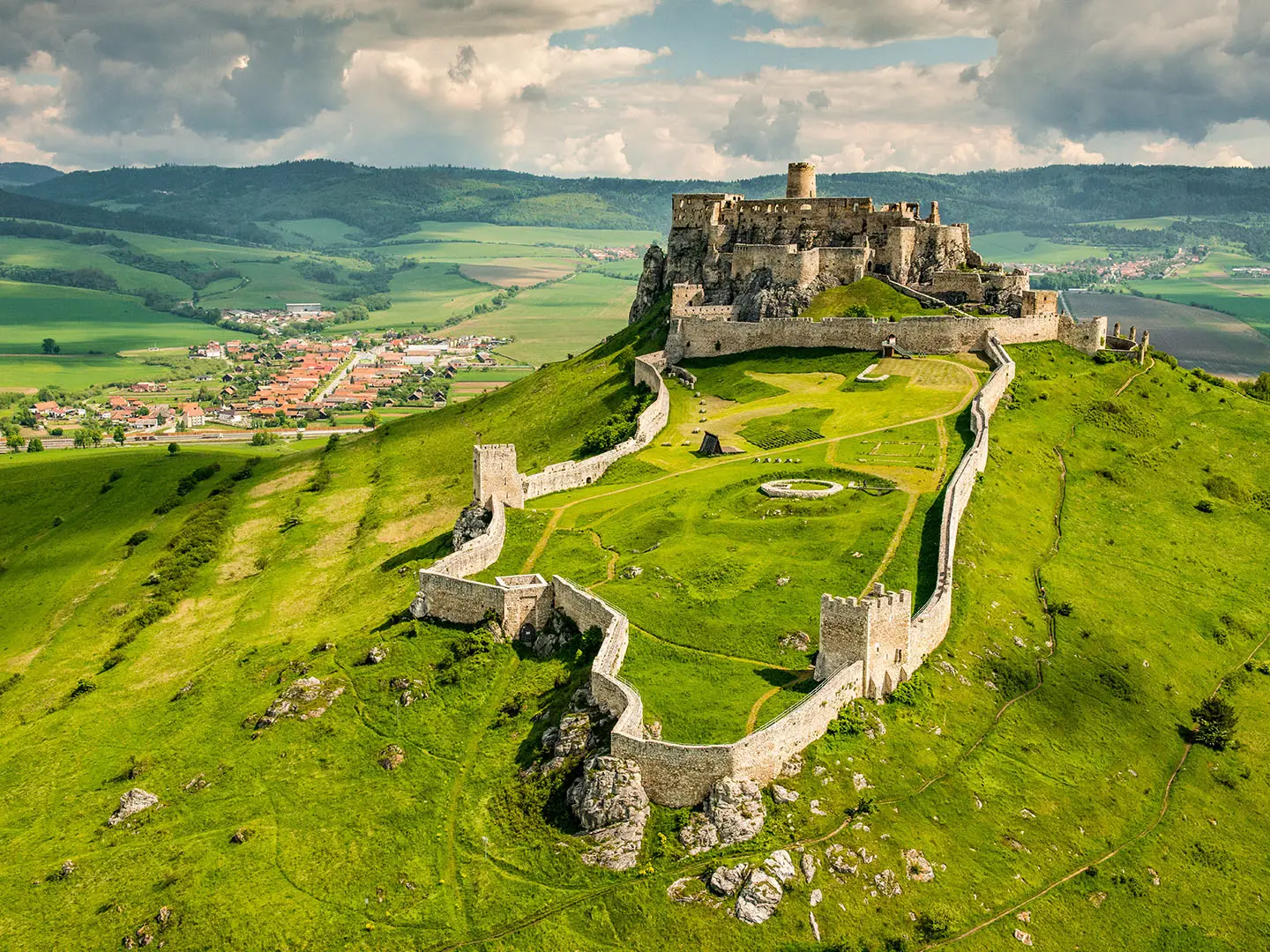
Spiš Castle was begun in the early 12th century on a travertine hill, with the oldest written reference dating to 1120, when it guarded the northern frontier of the Kingdom of Hungary. It became the administrative seat of Szepes, or Spiš, County. In the 15th century the Zápoľský family rebuilt it as an aristocratic residence, adding features including a knights’ hall, palace and late-Gothic chapel. A fire in 1780 left it in ruins. The castle, Spišská Kapitula, Žehra and the Dreveník travertines joined the UNESCO World Heritage List in 1993.
Notable highlights
- Spiš Castle (Spišský hrad, about 41,426 m² within the outer walls): The ruined medieval fortress covers the travertine summit and dominates the Spiš basin, making the short climb feel much bigger than its distance.
- UNESCO ensemble (inscribed in 1993): The walk sits inside the World Heritage area linking the castle with Spišská Kapitula, Žehra and the Dreveník travertine reserve.
- Spišská Kapitula (walled ecclesiastical town): This former church centre of the Spiš region is dominated by the twin-towered late-Romanesque St Martin’s Cathedral.
- Žehra Church (Romanesque-Gothic wall paintings): The Church of the Holy Spirit is known for rare medieval wall paintings and forms part of the same UNESCO listing.
- Travertine hills (Sivá Brada, Sobotisko and Dreveník): Sivá Brada is one of Slovakia’s few still-active travertine mounds, about 25 m high, while Dreveník has eroded rock formations and rare plants.
- Panoramas (Branisko, Levočské vrchy and High Tatras): From the castle and Dreveník, views extend across the Branisko hills and Levočské vrchy, with the High Tatras on the horizon.
Challenges to expect
The route is short, but do not treat it as flat sightseeing. The final climb to Spiš Castle is steep, rockier and uneven, and the exposed travertine hill can be hot in high summer or slippery when wet. There is no accommodation on the trail itself. Parking below the castle can fill in season, and castle access is separate from the free walking route, with upper-castle reconstruction affecting access as of 2026.
HikeList Score
Spiš Castle Trail scored 76/100 on HikeList's trail-quality metrics.
See score breakdownHide breakdown
- Ideal length 55
- Balanced challenge 100
- Scenery & wildness 58
- Varied terrain 83
- Accommodation 91
- Food & support 68
- Path quality 98
- Season flexibility 89
Computed from length, challenge, scenery & wildness, terrain variety, accommodation, food & support, path quality and season flexibility.
 Slovakia
Show more data Show less
- Hilly Travertine
- Open Grassland
- Limestone Slopes
- Dirt
- Rocky
- Uneven
- Hotels
- Guesthouses
- Hostels
- Family Friendly
- Pet Friendly
- Restrooms
- Picnic Areas
Photos from hikers
Taken on the trail by people who've reviewed Spiš Castle Trail.
Reviews
How would you rate Spiš Castle Trail?
Tap a star to start your review — you could be the first.