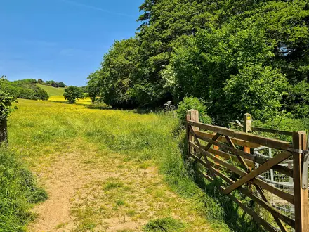
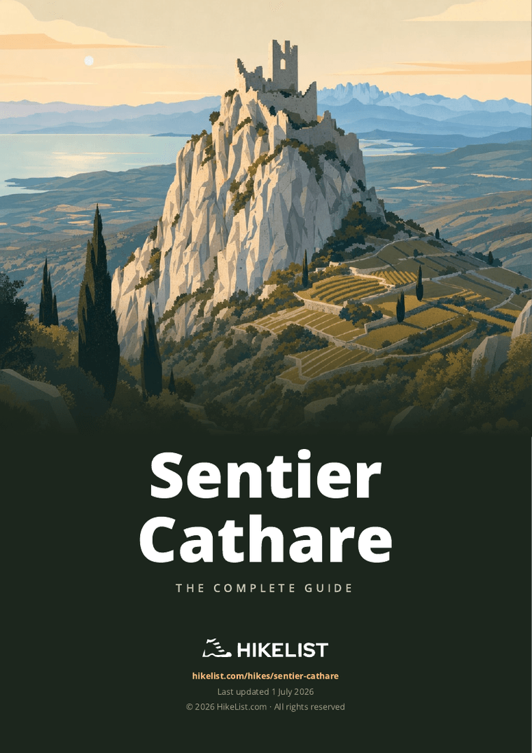
Sentier Cathare
How would you rate Sentier Cathare?
Tap a star to share your experience and help other hikers.
Sentier Cathare: GR 367 Across Cathar Country
HikeList Score
Sentier Cathare scored 86/100 on HikeList's trail-quality metrics.
See score breakdownHide breakdown
- Ideal length 89
- Balanced challenge 84
- Scenery & wildness 85
- Varied terrain 100
- Accommodation 84
- Food & support 81
- Path quality 84
- Season flexibility 76
Computed from length, challenge, scenery & wildness, terrain variety, accommodation, food & support, path quality and season flexibility.
The Sentier Cathare is a 250 km, point-to-point GR 367 hike across southern France, from Port-la-Nouvelle on the Mediterranean coast to Foix in the Pyrenean foothills. Allow about 12–14 days; the official split is 12 stages. It is a hard walk rather than a technical one: expect rocky tracks, steep castle approaches, exposed garrigue, remote sections and around 7,900 m of cumulative ascent. It suits fit walkers who want a village-to-village route linking major Cathar strongholds.
Route Overview
The route runs east to west, sea to mountains, crossing Aude and Ariège in Occitanie. From Port-la-Nouvelle it leaves coastal lagoons and salt marshes for vineyard hills around Durban-Corbières and Tuchan, then climbs through garrigue, limestone gorges and forest towards Puivert, the Plateau de Sault, Comus, Montségur and Roquefixade before finishing at Foix. Around stage 4 the GR 367 splits: a northern variant goes via Cucugnan, Bugarach and Quillan, while the southern main route links the castles via Caudiès-de-Fenouillèdes and Axat; the branches rejoin near Puivert. For easier French walking, compare the Canal du Midi Towpath; for higher Pyrenean scenery, see the Cirque de Gavarnie Trails.
Cathar Castles and the Albigensian Crusade
The Sentier Cathare links strongholds associated with Catharism, a dualist Christian movement that flourished in the Languedoc in the 12th and 13th centuries. Declared heretical, the Cathars were crushed during the Albigensian Crusade, which began in 1209. Montségur fell in 1244 and Quéribus in 1255, among the last refuges before the region was absorbed into the French crown. The modern waymarked trail was created in the 1980s to connect these sites on foot.
Notable highlights
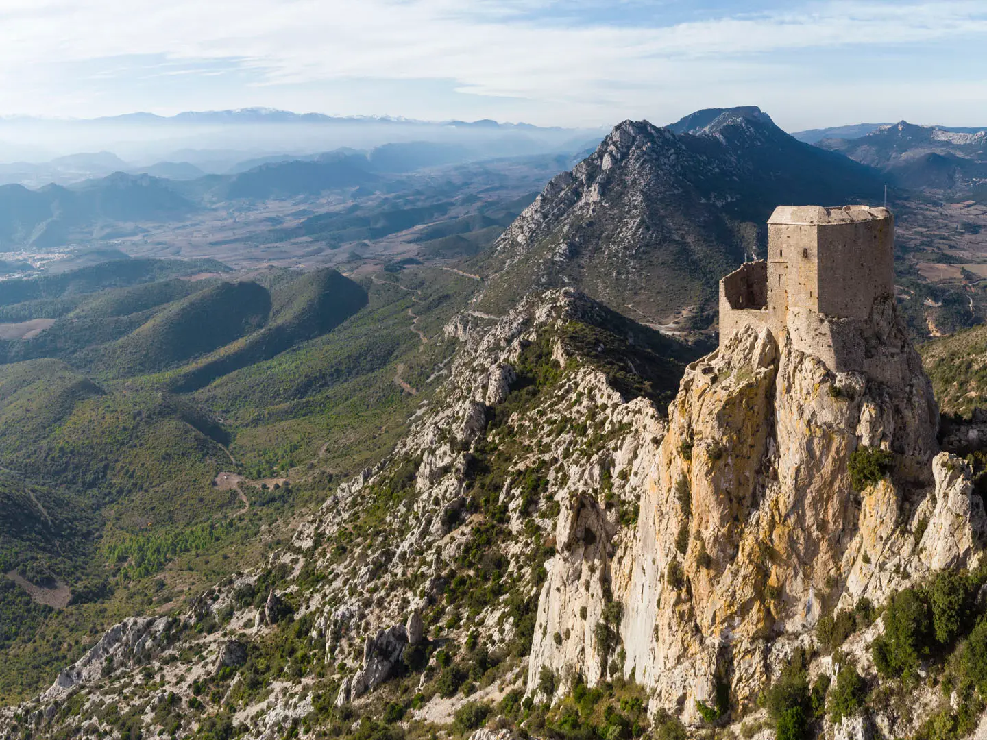
- Château de Peyrepertuse: A vast ruined fortress above Duilhac-sous-Peyrepertuse, spread along a 300 m limestone ridge at about 800 m. Its scale and airy position make it one of the defining sights of the route.
- Château de Quéribus: A slender keep on a rock spur, often described as the last Cathar stronghold. Surviving Cathars held out here after Montségur until its surrender in 1255.
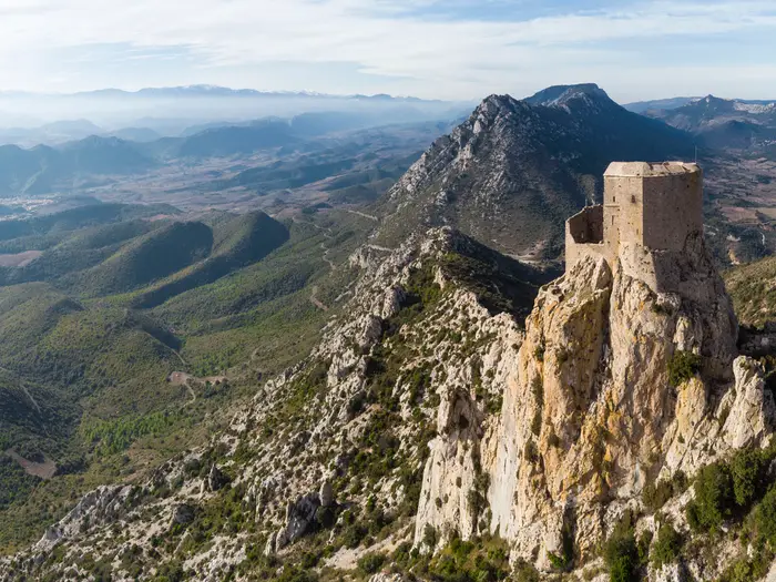
- Montségur: The most symbolic Cathar site, set on a dramatic pog, or rock pinnacle. After a siege ending in March 1244, around 205 Cathar Perfects chose execution rather than recantation.
- Gorges de Galamus: A narrow limestone canyon near the route around Cubières, with the cliff-clinging Ermitage Saint-Antoine. It is one of the most striking gorge sections on or near the trail.
- Pech de Bugarach: A 1,230 m landmark beside the northern variant and the highest summit of the Corbières massif. It is known locally for its “magnetic mountain” folklore, though it is a side ascent rather than the main line.
- Château de Foix: The three-towered medieval castle above Foix marks the western terminus. It gives the route a clear historical finish in the capital of the historic County of Foix.
Challenges to expect
The difficulty comes from cumulative effort: 250 km, about 7,900 m of ascent, 3h30–7h walking days, rocky tracks and steep approaches to castle sites. Summer heat can be severe on exposed garrigue, while winter can bring snow or closures at altitude. Some stages are remote with limited resupply, so book accommodation and plan food carefully. If you prefer lower, less remote French routes, see the Bordeaux to Arcachon Trail or the Chartreuse Trail (GR9 Segment).
HikeList Score
Sentier Cathare scored 86/100 on HikeList's trail-quality metrics.
See score breakdownHide breakdown
- Ideal length 89
- Balanced challenge 84
- Scenery & wildness 85
- Varied terrain 100
- Accommodation 84
- Food & support 81
- Path quality 84
- Season flexibility 76
Computed from length, challenge, scenery & wildness, terrain variety, accommodation, food & support, path quality and season flexibility.
Show more data Show less
- Coastal
- Hills
- Garrigue
- Forest
- Gorges
- Mountainous
- Dirt
- Rocky
- Gravel
- Road
- Gites D'Etape
- Chambres D'Hotes
- Auberges
- Hotels
- Pet Friendly
- Water Sources
- Campsites
- Shelters
Download Our Full Guide to Sentier Cathare FREE!
Get our comprehensive guide to this hike for free. Save it for later reading or print out at home.
In these collections
Photos from hikers
Taken on the trail by people who've reviewed Sentier Cathare.
Sentier Cathare: The Complete Guide
 i
Image by William Carlier
i
Image by William Carlier The Sentier Cathare is a hard, history-rich traverse from the Mediterranean shore at Port-la-Nouvelle to Foix in the Ariège foothills. It suits fit, experienced walkers who want a self-reliant village-to-village route rather than a technical mountain trek.
The trail leaves lagoons, salt marshes and beach behind, then climbs into Corbières vineyards, garrigue, limestone ridges and forest. Its great landmarks are the ruined Cathar castles: Aguilar, Quéribus, Peyrepertuse, Puilaurens, Puivert, Montségur and Roquefixade.
Further west, the walk becomes wilder and higher across the Plateau de Sault, Comus and the Gorges de la Frau, before the final approach to Foix beneath its three-towered château. The route is waymarked as GR 367, with a mid-route choice between the castle-rich main line and a shorter northern variant.
What the Sentier Cathare asks for is steady endurance, careful timing and good logistics. Expect roughly 250 km, around 7,900 m of ascent, rocky tracks, steep castle approaches, exposed heat in the garrigue and patchy services on some inland stages.
This guide covers stages, walking days, accommodation, food, transport, terrain and the common planning mistakes to avoid.
Stage-by-Stage Guide
The stage notes below follow the 12-day split used on this page. The Sentier Cathare has recognised variants in the middle section, including the castle-rich GR 367A line and a shorter northern GR 367 variant, so check the official topo-guide, IGN mapping and current accommodation availability before fixing overnight stops.
Stage 1: Port-la-Nouvelle to Durban-Corbières — 22 km
This opening stage leaves the Mediterranean shore at Port-la-Nouvelle and turns inland from lagoons, salt marshes and coastal flats towards the first Corbières hills. It is a clear sea-to-hills transition, with the walking becoming drier, stonier and more exposed as the GR 367 moves away from the coast.
The route passes through wine country around Roquefort-des-Corbières before reaching Durban-Corbières. Underfoot, expect a mix of dirt tracks, stony paths, gravel tracks and some minor road rather than technical mountain terrain.
Food and water planning starts here. Port-la-Nouvelle is the best place to begin with a full day’s supplies, and Durban-Corbières is the logical overnight stop; do not assume reliable services between the main villages without checking locally.
Port-la-Nouvelle has a railway station on the Narbonne–Perpignan line, making this the easiest place to reach car-free. Durban-Corbières is road-accessible, but onward public transport in the interior is limited and should not be relied on without checking current timetables.
Navigation is straightforward in concept: follow the red-and-white GR 367 waymarks inland from the beach. The main warning is exposure: on hot days this stage can feel severe because shade and water are limited once away from the coast.
Stage 2: Durban-Corbières to Tuchan — 20 km
The second day continues through the Corbières vineyards and Mediterranean garrigue, with a more inland, rural feel than the coast-to-Durban stage. The walking is still non-technical, but the accumulated heat, stony surfaces and rolling vineyard hills make it more demanding than the distance alone suggests.
This is part of the AOC Corbières and Fitou wine-country section of the trail. The scenery is open and sun-exposed, with terraced vines, scrubby hills and the first real sense of the Cathar castle landscape ahead.
Tuchan is the end-of-stage base and is associated with Château d’Aguilar, one of the “five sons of Carcassonne” royal frontier fortresses. A castle visit may add time and distance depending on the exact line taken, so check opening hours and whether the visit fits the walking day.
Carry the food and water needed for the full stage unless services have been checked in advance. Accommodation in Tuchan is likely to be modest — gîte, chambres d’hôtes, auberge or small hotel style — and should be booked ahead, especially in spring and autumn.
There is road access at both ends, but this is already a section where public transport becomes thin. For stage-hiking or luggage support, taxi, shuttle or baggage-transfer arrangements should be organised before travelling.
Stage 3: Tuchan to Duilhac-sous-Peyrepertuse — 19 km
This is one of the classic castle stages of the Sentier Cathare, linking vineyard country with the limestone crags around Cucugnan and Duilhac-sous-Peyrepertuse. It is not technical walking, but the terrain becomes rockier and more dramatic, with steeper pull-ups around the perched castle sites.
The stage passes the area of Padern and Cucugnan, with Château de Quéribus rising on a rock spire near Cucugnan. Quéribus is historically significant as the last Cathar stronghold, surrendering in 1255, and it is one of the most striking landmarks on the eastern half of the walk.
The day finishes beneath Château de Peyrepertuse, the vast ruined fortress stretched along a limestone crest above Duilhac-sous-Peyrepertuse. As with Quéribus and Aguilar, any castle visit may involve extra climbing, extra time and separate opening hours or entry arrangements; this should be checked before travelling.
Water and food should be treated conservatively on this stage. Use Tuchan and Duilhac-sous-Peyrepertuse as the main planning points, and carry enough to be self-sufficient across exposed garrigue and rocky sections.
Accommodation at Duilhac-sous-Peyrepertuse is in the small-village category, so book early and have a fallback plan if beds are full. Road access is possible, but routine public transport should not be assumed.
Navigation requires attention where the GR line, village access paths and castle approaches overlap. Stay alert for red-and-white GR waymarks and distinguish the through-route from out-and-back castle spurs.
Stage 4: Duilhac-sous-Peyrepertuse to Cubières-sur-Cinoble — 18 km
This stage leaves the Peyrepertuse area and heads towards the limestone canyon country around Cubières-sur-Cinoble. It is a varied day of rocky paths, garrigue, ridges and gorge scenery, with the feel of the route shifting from vineyard hills towards more rugged inland terrain.
The main natural highlight is the Gorges de Galamus, a narrow limestone canyon on the Aude/Pyrénées-Orientales border near Cubières. The cliff-clinging Ermitage Saint-Antoine is part of the gorge’s character and makes this one of the most memorable landscape passages on the route.
The walking can be hot and exposed before and after shaded or enclosed sections. Rock underfoot may be rough, and progress can be slower than expected if visiting sites or pausing in the gorge area.
Plan food and water carefully. Cubières-sur-Cinoble is a small end-of-stage village, and services can be limited or seasonal; accommodation and meals should be arranged in advance.
Road access exists in the area, but the gorge and surrounding villages are not places to improvise public transport plans at the end of a long day. Shuttle or taxi options should be arranged ahead where needed.
Navigation is generally by GR waymarks, but the gorge area can have side paths, road sections and visitor routes. Keep the topo-guide or mapped GPX to hand rather than relying only on waymarks in busy or complex areas.
Stage 5: Cubières-sur-Cinoble to Camps-sur-l’Agly — 15 km
This is a shorter stage on paper, but it sits in a remote part of the route where logistics matter more than distance. The terrain remains a mix of limestone, garrigue, tracks and minor road, with the same heat and water issues as the previous Corbières stages.
The day links small inland villages rather than major service centres. It is best treated as a positioning stage between the Galamus area and the next longer push towards Quillan.
Food and water availability should be checked before leaving Cubières-sur-Cinoble. Carry a full day’s supply if there is any doubt, as short distance does not mean easy resupply.
Camps-sur-l’Agly is a small overnight stop, so accommodation should be booked well ahead. If no bed is available, a pre-arranged transfer may be needed rather than trying to solve it on arrival.
This is also part of the route where the different GR 367 / GR 367A descriptions can become confusing. If the aim is to include Château de Puilaurens and Axat on the castle-rich line, check the official mapping carefully, because the 12-stage split used here continues via Camps-sur-l’Agly and Quillan and may not match every guidebook itinerary.
Stage 6: Camps-sur-l’Agly to Quillan — 23 km
At around 23 km, this is one of the longer stages in the 12-day schedule and should be started with a full pack of food and water. The route continues through remote inland country on stony tracks, forest roads, rough paths and occasional minor road, with limited opportunities to shorten the day once committed.
This is a key planning stage because of the Sentier Cathare’s mid-route variants. The broader route network includes the castle-rich line via Caudiès-de-Fenouillèdes, Puilaurens and Axat, while the shorter northern variant heads more directly towards Quillan and the later rejoining area before Puivert.
If Château de Puilaurens is a priority, do not rely on this 12-stage outline alone. Check the official topo-guide and current GR 367 / GR 367A routing before booking, because Puilaurens is a major Cathar castle highlight but is not explicitly reached by the stage list used here.
Quillan is the end-of-stage halt and is a more substantial practical stop than some of the smaller villages before it. Even so, accommodation should still be booked ahead in walking season, particularly if relying on baggage transfer or fixed-stage walking.
Public transport and road access are better considered in advance rather than improvised. The remote middle of the Sentier Cathare has limited public transport, and shuttle, taxi or baggage-transfer services are commonly used between some villages.
Navigation needs more care than on simple village-to-village sections because of variant lines and possible differences between guidebooks, waymarks and digital mapping. Carry current IGN mapping or the official FFRandonnée topo-guide and know which line has been chosen before leaving Camps-sur-l’Agly.
Stage 7: Quillan to Puivert — 18 km
This stage moves the route towards the Plateau de Sault and the eastern Pyrenean foothills. The walking becomes greener and more upland in character, with forest, pasture edges and stony tracks replacing much of the earlier vineyard and garrigue landscape.
Puivert is a major highlight because of Château de Puivert, an unusually well-preserved castle on a low hill facing the Pyrenees. Its keep and vaulted rooms, including the salle des musiciens, make it one of the most rewarding castle stops on the western half of the route.
The terrain is still not technical, but the cumulative effort of the previous week begins to tell. Expect steady climbing and rougher underfoot conditions in places, with weather feeling less Mediterranean and more upland as the route gains height.
Quillan is the sensible place to resupply before setting out. Puivert has accommodation options in the general gîte/chambres d’hôtes/auberge pattern, but availability is limited enough that booking ahead is important.
Road access exists at both ends, but public transport should be checked before travelling. This is a practical stage for walkers using pre-booked baggage transfer, as the route is now moving through more scattered settlements.
Navigation is mainly by the GR waymarks, but check any local diversions before leaving Quillan. If adding a visit to Château de Puivert, allow time at the end of the day rather than treating it as an afterthought.
Stage 8: Puivert to Espezel — 20 km
This stage enters the Plateau de Sault section in earnest, with the route moving through upland forest, pasture and quieter high-country terrain. It is one of the stages where the Sentier Cathare starts to feel like a mountain-foothill traverse rather than a Mediterranean trail.
The walking is generally on tracks, forest roads and paths rather than exposed scrambling or technical ground. The challenge is the steady mileage, the cumulative ascent and the more remote feel between villages.
Views begin to open towards the Pyrenean foothills, and the landscape becomes cooler and more pastoral than the Corbières. In poor weather, however, this upland character can mean wind, rain and reduced visibility rather than the dry heat of the earlier stages.
Carry sufficient food and water from Puivert, as intermediate resupply cannot be assumed. Espezel is the end-of-stage settlement for the night, with accommodation that should be reserved in advance.
Road access is possible, but this is not a stage to depend on spontaneous public transport. For section walkers, transfers should be arranged before starting the day.
Navigation is usually straightforward where the GR is well waymarked, but forest tracks can be confusing if several tracks branch close together. A paper map or offline mapping is useful here, especially in mist or poor weather.
Stage 9: Espezel to Comus — 17 km
This is a high Plateau de Sault stage and forms part of the wild upland heart of the Sentier Cathare. The route crosses forest and pastoral terrain at around 1,200–1,350 m, with the trail’s topographic high ground in this section rather than at one of the castle summits.
The walking is not exposed in a climbing sense, but it is more upland and remote than the early Corbières stages. Tracks can be stony, forested sections may be slower to navigate, and weather can change the character of the day quickly.
Comus is the gateway to the Gorges de la Frau section ahead. The village is a small but important overnight stop, so accommodation and evening meals should be fixed before arrival.
Food and water should be carried for the full stage unless current services have been checked. The higher plateau is not a place to rely on finding shops or cafés en route.
Road access is limited to the village network, and public transport is sparse. Walkers using luggage transfer or shuttles should confirm pick-up and drop-off details in advance.
In winter or early spring, conditions on the Plateau de Sault can be very different from the coast, with possible snow at altitude. Spring and autumn are the main walking seasons, but even then this stage deserves a proper forecast check before setting out.
Stage 10: Comus to Montségur — 14 km
Although shorter than many days, this is a major stage because it links the high plateau, the Gorges de la Frau and the symbolic Cathar site of Montségur. It should not be dismissed as an easy half-day if visiting the castle or if weather is poor.
The Gorges de la Frau form a deep limestone cleft and one of the most dramatic natural passages on the route. Beyond the gorge, the approach to Montségur brings the trail into the historic and visual heart of the western Sentier Cathare.
Montségur’s ruined castle stands on a steep rock “pog” above the village. The castle is historically central to the route: after the siege ending in March 1244, around 200–225 Cathar Perfects were burned rather than recant.
The climb to the castle is a separate effort from simply reaching the village, and it adds time, ascent and rougher footing. Check opening arrangements and allow enough daylight if planning to visit after completing the stage.
Carry food and water from Comus, and do not assume there will be reliable intermediate services. Montségur is a small, popular castle village, so beds should be booked early in the main walking seasons.
Navigation through the gorge and onwards should be checked against current mapping, especially after bad weather or if diversions are in place. The warning here is not technical exposure but steep, rocky ground, fatigue and the temptation to rush the Montségur visit at the end of the day.
Stage 11: Montségur to Roquefixade — 17 km
The penultimate stage crosses the Ariège foothills between two important Cathar sites. It has a more Pyrenean feel than the opening week, with rough tracks, woodland, open sections and views towards the mountains.
Leaving Montségur, the stage carries the weight of the previous day’s castle landscape but becomes quieter as it heads towards Roquefixade. The main highlight is Château de Roquefixade, a cliff-edge ruined castle on a rock bar above the village.
The walking remains non-technical but can be tiring, especially after the cumulative ascent of the route so far. Expect stony ground and short steep sections rather than smooth valley walking.
Food and water should be planned from Montségur, with Roquefixade treated as the next certain overnight point. Accommodation is limited in small villages along this part of the route, so booking ahead is essential.
Road access is possible at the village, but public transport should be checked before travelling and not assumed. This is a common section where a pre-arranged taxi or shuttle may be more realistic than scheduled transport.
Navigation is by GR waymarks, but castle access paths and village tracks can create local confusion. If visiting Château de Roquefixade, separate the castle detour from the through-route in the day’s timing.
Stage 12: Roquefixade to Foix — 17 km
The final stage descends through the Ariège foothills to Foix, finishing beneath the three-towered Château de Foix. It is a satisfying end to the sea-to-mountains traverse, with the landscape gradually becoming more settled as the route approaches the historic county capital.
The terrain is still mixed: dirt paths, stony tracks, forest or hillside sections and some minor road near settlement. Do not treat it as a simple town approach until the final kilometres are complete.
Château de Foix is the visual finish of the walk and the historic seat of the Counts of Foix. Foix itself is the practical endpoint, with more services than the small villages of the preceding stages.
Carry enough water and snacks from Roquefixade, particularly in hot weather, but the logistics ease considerably once in Foix. Accommodation is generally easier to arrange here than in the remote middle of the route, though booking ahead is still sensible in busy periods.
Foix has a railway station on the Toulouse–Latour-de-Carol line, with direct trains to Toulouse and onward TGV connections. This makes it the natural place to end a car-free traverse or to reverse the route and walk from the mountains to the Mediterranean.
Navigation remains on the GR 367 to the finish, but urban approaches can sometimes be less obvious than open-country waymarks. Keep following the red-and-white balisage until the route is clearly complete in Foix.
Recommended Itinerary
The most practical split for the Sentier Cathare is 12 walking days, which keeps most stages in the 14–23 km range while still leaving enough time for castle visits, hot-weather pacing and the thin accommodation pattern inland. Distances are approximate: castle spurs, the GR 367 / GR 367A variants and local diversions can change the day’s actual distance, so check official mapping before booking beds.
The table below follows the 12-day stage data used for this guide. The middle of the route has important variants: the castle-rich main Sentier Cathare line is often signed GR 367A and goes via Caudiès-de-Fenouillèdes, Puilaurens and Axat, while a shorter northern GR 367 variant goes via Bugarach and Quillan. If Château de Puilaurens is a priority, do not assume every Duilhac–Cubières–Camps–Quillan itinerary reaches it; check the current official route line before fixing accommodation.
Standard 12-day itinerary
| Day | From | To | Approx. distance | Why this stage makes sense | Services/accommodation notes |
|---|---|---|---|---|---|
| 1 | Port-la-Nouvelle | Durban-Corbières | 22 km | A full first day takes the route from the Mediterranean shore, lagoons and salt marshes into the Corbières foothills, avoiding an overly short start. | Start with water and food already sorted; the exposed coastal and garrigue sections can feel hot even outside summer. Book ahead in Durban-Corbières. |
| 2 | Durban-Corbières | Tuchan | 20 km | A steady vineyard-and-garrigue stage through the Corbières, with the route beginning to feel more inland and self-reliant. | Tuchan is a key overnight stop for the early castle section. Confirm accommodation and evening meal arrangements in advance. |
| 3 | Tuchan | Duilhac-sous-Peyrepertuse | 19 km | This is one of the classic Cathar castle days, linking the Tuchan area towards Padern, Cucugnan and Duilhac-sous-Peyrepertuse, with access to major sites such as Château d’Aguilar, Château de Quéribus and Château de Peyrepertuse depending on route choices and spurs. | Castle visits can add time and climbing. Do not plan this as a short day if entering sites or taking spurs; check opening hours and fees before travelling. |
| 4 | Duilhac-sous-Peyrepertuse | Cubières-sur-Cinoble | 18 km | A manageable distance after the Peyrepertuse area, with the route moving towards the limestone gorge country around the Gorges de Galamus. | Accommodation is limited in the smaller villages on this part of the trail. Book early and carry enough food for the day. |
| 5 | Cubières-sur-Cinoble | Camps-sur-l’Agly | 15 km | A shorter stage gives useful margin for the Gorges de Galamus area and for heat, rocky ground or slower progress after the castle-heavy early days. | This is not a stage to leave accommodation to chance. Check current services and water availability before setting off. |
| 6 | Camps-sur-l’Agly | Quillan | 23 km | One of the longer days in the standard schedule, moving from the more remote Corbières/Fenouillèdes edge towards a larger valley town. | Start early in warm weather and carry adequate water. Quillan is a useful resupply and recovery point before the Plateau de Sault section. |
| 7 | Quillan | Puivert | 18 km | A moderate day out of Quillan towards Château de Puivert, marking the transition from lower country towards the upland Plateau de Sault. | Puivert is an important overnight stop and castle village. Book beds ahead, especially in the main spring and autumn walking periods. |
| 8 | Puivert | Espezel | 20 km | This stage keeps progress steady across the higher, more pastoral terrain without making the approach to Comus too long. | Services become patchier on the plateau. Carry food and check whether your accommodation provides dinner. |
| 9 | Espezel | Comus | 17 km | A sensible upland stage into the high Plateau de Sault area, setting up the next day through the wild heart of the route towards Montségur. | Expect a more remote feel here than on the early Corbières stages. Check water points, weather and accommodation opening before travelling. |
| 10 | Comus | Montségur | 14 km | A shorter but significant day through the high ground around the Plateau de Sault and the Gorges de la Frau, finishing beneath the most symbolic Cathar castle. | Do not underestimate the day because of the distance; terrain, weather and the Montségur castle visit can all add effort. Book early in Montségur. |
| 11 | Montségur | Roquefixade | 17 km | A strong penultimate stage across the Ariège foothills, linking Montségur with another cliff-edge Cathar site at Roquefixade. | Accommodation is limited compared with larger towns. Confirm meals, bed availability and any baggage-transfer arrangements ahead. |
| 12 | Roquefixade | Foix | 17 km | A final moderate day into Foix, finishing beneath the Château de Foix with rail connections for onward travel. | Foix has the most useful end-of-walk services. If travelling onward the same day, allow margin for delays and check train times before booking. |
Slower 13–14 day variant
A slower schedule suits walkers who want time for the castles, prefer shorter hot-weather days, or are carrying camping gear. It is also the safer choice if accommodation availability forces an extra overnight in one of the castle villages.
Good ways to add time include:
- Split the opening day around Roquefort-des-Corbières rather than walking Port-la-Nouvelle to Durban-Corbières in one push. Distances for the split should be checked on official mapping before booking.
- Add a castle day around Cucugnan / Duilhac-sous-Peyrepertuse for Château de Quéribus and Château de Peyrepertuse, rather than squeezing both into a through-walking day.
- Add time around Montségur if visiting the castle properly, especially after the Plateau de Sault and Gorges de la Frau section.
This version is usually the best fit for walkers who value historical sites as much as daily mileage. It also gives more flexibility if spring storms, autumn rain or high temperatures slow progress.
Faster 11-day variant
The 12-day itinerary is already a brisk schedule for a 250 km route with around 7,900 m of ascent. A faster version is only sensible for very fit walkers travelling light, with accommodation and food arrangements fixed in advance.
The most realistic compression is to combine one of the shorter upland stages, for example Comus to Montségur and Montségur to Roquefixade into a long Comus to Roquefixade day of about 31 km. This removes the overnight in Montségur, so it is a poor choice if the castle visit is central to the trip.
Avoid planning a faster itinerary around uncertain public transport in the middle of the route. The remote stages have limited services, and missed accommodation or food stops can create bigger problems than the distance itself.
Planning the Route
How many days to allow
Most walkers should allow 12–14 walking days for the Sentier Cathare. A 12-day crossing suits fit walkers with accommodation booked in advance, a light pack and no major delays for castle visits; 13–14 days gives more margin for heat, long stony stages and the steep pull-ups to the fortress sites.
Do not plan this as a trail where each day can be freely adjusted on the hill. Overnight options are concentrated in villages, and provision is patchy on the more remote inland and upland sections, so the practical itinerary is usually dictated by where beds are available.
Add buffer time if the aim is to visit the major Cathar castles properly. Château d'Aguilar, Château de Quéribus, Château de Peyrepertuse, Château de Puilaurens, Château de Puivert, Montségur and Roquefixade can all affect the day’s timing through spurs, steep approaches, opening hours and entry arrangements. Seasonal opening hours and fees should be checked before travelling.
Choose the variant before booking beds
The key route-planning decision is the middle section variant. The castle-rich main Sentier Cathare line, often signed as GR 367A, runs via places such as Caudiès-de-Fenouillèdes, Puilaurens and Axat. A shorter northern GR 367 variant runs via Cucugnan, Bugarach and Quillan and misses some of the castle-focused walking.
The variants split around Duilhac-sous-Peyrepertuse / Cucugnan and rejoin near Coudons before Puivert. Decide which line is being followed before booking accommodation, arranging baggage transfer or downloading GPX files. In particular, check whether an itinerary intentionally includes or omits Château de Puilaurens, as it is one of the major Cathar sites but is not on every stage plan.
Published distances also differ depending on whether the main line, variants and castle spurs are counted. Treat the trail as an approximately 250 km undertaking for planning purposes, and allow extra time and energy for any off-route castle visits.
Fast crossing or slower itinerary?
A fast 12-day crossing is realistic for strong walkers who are comfortable with long days of 3h30–8h, repeated ascent and rocky tracks. It is not the best approach if accommodation is scarce, the forecast is hot, or castle visits are a priority.
A slower 13–14 day plan is usually more forgiving. It gives more flexibility around the exposed garrigue in the Corbières, the high Plateau de Sault section around Puivert, Espezel and Comus, and the final Pyrenean foothill stages through Montségur, Roquefixade and Foix.
Direction of travel
The standard direction is Port-la-Nouvelle to Foix, starting on the Mediterranean shore and building gradually towards the Plateau de Sault and the Ariège foothills. This gives a strong sea-to-mountains progression and places the highest ground later in the walk.
The reverse direction is also practical, and some walkers prefer to go from the mountains to the Mediterranean. Direction should mainly be chosen around train times, booked accommodation and weather, rather than any technical difference in the walking.
Shortening, extending and section hiking
The simplest way to shorten the walk is to use the shorter northern GR 367 variant rather than the castle-rich GR 367A line. The trade-off is that some of the major Cathar castle content is reduced or missed.
The easiest way to extend the walk is to include more castle spurs, take time inside the sites, or build in a rest or half-day around the more historic villages. Total mileage rises further if both variants are walked, but that requires careful transport and accommodation planning.
Section hiking is possible, but it is not as straightforward as on routes with frequent rail access. Port-la-Nouvelle and Foix both have railway stations, while the remote middle stages have limited public transport. For partial sections, expect to use taxis, shuttles or baggage-transfer operators such as La Malle Postale; availability and current coverage should be checked before travelling.
Planning priorities
| Priority | What matters on this trail |
|---|---|
| Accommodation | Book gîtes d'étape, chambres d'hôtes, auberges, small hotels or campsites ahead, especially in spring and autumn and around the castle villages. Do not rely on finding a bed spontaneously in the remote middle stages. |
| Food | Resupply can be thin between villages, so plan lunches and emergency food before leaving each overnight stop. Opening days and hours in small villages should be checked before travelling. |
| Water | The exposed Corbières and garrigue sections can be very hot, and water is scarce on some stages. Start each day with enough water for the full stage unless a reliable refill point has been identified in advance. |
| Navigation | The route is waymarked with GR 367 red-and-white balisage, but the variant network makes maps essential. Carry the official topo-guide, relevant IGN mapping and an offline GPX track for the chosen line. |
| Transport | Rail access is good at the ends: Port-la-Nouvelle is on the Narbonne–Perpignan line, and Foix is on the Toulouse–Latour-de-Carol line. The centre of the route needs more planning, with taxis or shuttles often more realistic than public transport. |
| Weather | Spring and autumn are the main walking seasons. High summer heat on the exposed garrigue can be severe, while winter can bring difficult conditions on higher ground such as the Plateau de Sault. |
| Castles | Castle visits add time, ascent and sometimes entry fees. Check seasonal opening hours before building a day around a visit. |
No single planning issue is difficult on its own, but the combination matters: long village-to-village days, limited services, variant choices, heat exposure and castle detours all need to be fixed before the first train ticket and bed bookings are made.
Towns, Villages and Overnight Stops
Accommodation on the Sentier Cathare is village-based and modest: gîtes d'étape, chambres d'hôtes, auberges, small hotels and some campsites. The main planning issue is not luxury versus budget, but whether there is a bed and an evening meal in the right village on the right night.
Book the inland and upland stages well ahead, especially in spring and autumn when the walking season is concentrated. Do not assume every small village has a shop, café or restaurant open daily; opening days, meal availability and gîte seasons should be checked before travelling.
The two mid-route lines affect overnight planning. The castle-rich southern line, often treated as GR 367A, runs by places such as Caudiès-de-Fenouillèdes, Puilaurens and Axat, while the shorter northern GR 367 variant goes via Bugarach and Quillan before rejoining near Coudons. Choose the line before booking, as accommodation reservations and baggage-transfer arrangements need to match it.
Port-la-Nouvelle
Port-la-Nouvelle is the Mediterranean starting point, with the GR 367 leaving the shore and heading inland through lagoons, salt marshes and then Corbières country. It is a sensible arrival-night stop rather than a place to rush through, particularly if travelling by train.
The town has its own station on the Narbonne–Perpignan line, making it one of the easiest points on the whole route to reach without a car. Accommodation and food options should be easier to arrange here than in the small inland villages, but walkers should still book ahead if arriving late or starting in a busy holiday period.
Roquefort-des-Corbières
Roquefort-des-Corbières sits on the early inland section between Port-la-Nouvelle and Durban-Corbières. It is useful if the first day out of the coast needs to be shortened, or if heat, late arrival or a heavy pack makes the full push to Durban-Corbières unattractive.
Treat it as a planning option rather than an assumed overnight. Accommodation, meals and onward transport should be checked before travelling, as the practical trail rhythm more commonly places the first night at Durban-Corbières.
Durban-Corbières
Durban-Corbières is the usual first overnight on a 12-day split from Port-la-Nouvelle. It lies in the Corbières vineyard hills and is a useful place to reset after the transition from coast and salt marshes into hotter, stonier inland walking.
This is a key booking point because it anchors the first full stage. Expect modest village accommodation rather than a wide hotel choice, and check evening meals and next-day provisions in advance.
Tuchan
Tuchan is the next major overnight after Durban-Corbières and sits in the Corbières/Fitou wine country. It is also the practical base for the section around Château d'Aguilar, one of the early Cathar fortress sites.
For most walkers, Tuchan is a necessary stop rather than an optional detour. Book a bed before arrival and make sure food is arranged, as the following stages move deeper into castle country where services become more uneven.
Padern
Padern lies between Tuchan and the Cucugnan/Duilhac-sous-Peyrepertuse area. It can be useful for breaking up the castle approach stages or adjusting the itinerary if accommodation is full in the more obvious overnight villages.
Do not rely on Padern as an unplanned fallback. Accommodation, food and any taxi or baggage-transfer arrangements should be checked before travelling.
Cucugnan
Cucugnan is one of the key castle villages on the eastern half of the route, associated with the approach to Château de Quéribus. It is a useful overnight or meal stop depending on whether the day is being shaped around Quéribus, Peyrepertuse, or both.
Because it sits in a popular castle area, beds can be tight in the main walking seasons. Reserve early, and check whether accommodation provides dinner or whether food needs to be arranged elsewhere.
Duilhac-sous-Peyrepertuse
Duilhac-sous-Peyrepertuse is a major practical stop below Château de Peyrepertuse. It is a common overnight on the east-to-west itinerary and a good place to allow time for the steep castle approach without overloading the day.
Accommodation is important to book ahead here, especially if visiting Peyrepertuse as well as walking the stage. Food and breakfast arrangements should be confirmed when booking, as the next day may include remote limestone and gorge terrain.
Cubières-sur-Cinoble
Cubières-sur-Cinoble appears on the common stage split after Duilhac-sous-Peyrepertuse and is linked with the Gorges de Galamus section. It works as an overnight if following the Duilhac–Cubières–Camps–Quillan rhythm.
Services should be treated as limited. Confirm the exact line being walked, the availability of a bed, evening meal and any baggage transfer before committing to this stop.
Camps-sur-l'Agly
Camps-sur-l'Agly is another small overnight on the stage pattern between the Gorges de Galamus area and the route towards Quillan or the southern variant. It is a functional stop for spacing the days rather than a major resupply centre.
Plan it carefully: assume limited shops and limited eating options unless your accommodation states otherwise. This should be checked before travelling.
Caudiès-de-Fenouillèdes
Caudiès-de-Fenouillèdes is relevant to the southern GR 367A line, the castle-rich variant that takes walkers towards Puilaurens and Axat rather than the shorter northern line. It may be used as an overnight or staging point depending on the exact variant and stage lengths chosen.
This is where route choice starts to matter for bookings. If using the southern line, check accommodation and food availability here before reserving later nights at Puilaurens, Axat or beyond.
Bugarach
Bugarach belongs to the northern GR 367 variant, which is shorter and more direct than the castle-rich southern line. It is only relevant if choosing that variant rather than the Caudiès-de-Fenouillèdes–Puilaurens–Axat line.
Use Bugarach to shape the northern itinerary, but do not assume it offers the same accommodation pattern as the southern route. Beds, meals and any onward transport should be checked before travelling.
Puilaurens
Puilaurens is on the southern castle-rich line and is important because of Château de Puilaurens, a well-preserved fortress on a forested crag above the upper Aude. Walkers choosing the GR 367A line often plan around this castle rather than bypassing it on the shorter northern variant.
Accommodation planning here needs care. If no suitable overnight is available in or near Puilaurens, the stage may need to be shaped around Axat or another booked stop; this should be arranged before travelling.
Axat
Axat is a practical staging point on the southern line after the Puilaurens area. It helps link the castle-rich middle section with the route towards Quirbajou, Coudons, Nébias and Puivert.
It is a useful place to consider for accommodation if Puilaurens does not fit the day. Food, beds, baggage-transfer coverage and any local transport should be checked before booking the surrounding stages.
Quirbajou
Quirbajou lies on the inland middle section between the southern variant area and the route towards Coudons and Nébias. It is a small-route stop rather than a guaranteed service centre.
Use it only with a confirmed booking or a clear plan for passing through. Do not assume food, shops or transport will be available without checking in advance.
Coudons
Coudons is significant because the mid-route variants rejoin near this area before the walk continues towards Puivert. It can be useful for aligning itineraries after either the southern castle-rich route or the northern variant.
As with nearby small villages, this is not a place to improvise. Accommodation, meals and luggage logistics should be confirmed before relying on it as an overnight.
Nébias
Nébias sits before Puivert on the approach to the Plateau de Sault stages. It can work as a staging village if Puivert is full or if the day needs shortening.
Check all practical details before committing to Nébias. In this part of the route, the gap between villages is manageable on paper but can feel harder in heat or poor weather if food and water planning is loose.
Quillan
Quillan appears on a common 12-day stage split between Camps-sur-l'Agly and Puivert, and is also relevant to the shorter northern variant via Bugarach. It is a practical overnight for walkers following that line rather than the southern Puilaurens/Axat route.
Because the Sentier Cathare has variant options through this middle section, check that your accommodation bookings, luggage transfers and maps all match the same route. Do not book Quillan automatically if your plan is to take the GR 367A line via Puilaurens and Axat.
Puivert
Puivert is one of the main anchor stops in the middle of the route, with Château de Puivert nearby and the high Plateau de Sault stages ahead. It is a common overnight whether arriving from the northern route or after the southern variant has rejoined.
This is a good place to organise carefully: confirm dinner, breakfast and next-day supplies, as the route soon climbs into more upland, pastoral country. Accommodation should be booked ahead in the main walking seasons.
Espezel
Espezel sits on the Plateau de Sault section between Puivert and Comus. It is a useful overnight for keeping the upland crossing manageable and for avoiding an overlong day across higher, more exposed country.
Services are not something to leave to chance. Check accommodation, meals and any provisions before travelling, particularly outside the core spring and autumn walking periods.
Comus
Comus is a key overnight on the high section around the Plateau de Sault and before the Gorges de la Frau and Montségur stage. This is one of the more remote-feeling parts of the route, with upland forest, pasture and the trail's highest ground nearby.
Book Comus early. It is not a place to arrive without a bed arranged, and food availability should be confirmed when reserving accommodation.
Montségur
Montségur is one of the most important stops on the Sentier Cathare, both practically and historically. The village sits below the steep pog crowned by the ruined Château de Montségur, the symbolic Cathar site associated with the siege ending in 1244.
Most walkers will want enough time here for the castle approach without squeezing it into an already long day. Accommodation can be in demand around this famous stop, so book ahead and confirm meals before arrival.
Roquefixade
Roquefixade is the usual penultimate overnight before Foix. The ruined Château de Roquefixade stands above the village, and the stop gives a clean final-day walk into the Ariège capital.
Treat Roquefixade as a small village stop with limited flexibility. Reserve accommodation, check dinner arrangements and avoid assuming there will be late-notice alternatives nearby.
Foix
Foix is the western terminus beneath the three-towered Château de Foix. It is the easiest place on the route to finish cleanly, recover, and connect back into the wider French rail network.
Foix has a station on the Toulouse–Latour-de-Carol line, with direct trains to Toulouse and onward TGV connections. It is the most practical final overnight, especially if a late finish would make same-day onward travel tight.
Getting to the Start
The Sentier Cathare starts in Port-la-Nouvelle, on the Mediterranean coast in Aude. The practical access point is Port-la-Nouvelle station, with the GR 367 red-and-white waymarks leading inland from the beach after the coastal start.
By train
Port-la-Nouvelle has its own railway station on the Narbonne–Perpignan line. For most walkers arriving from elsewhere in France, the simplest approach is to take a TGV to Narbonne, then connect onto a regional train to Port-la-Nouvelle.
Perpignan is the other useful rail direction on the same line, so it can also work as an approach city depending on where you are travelling from. Current regional train times and connections should be checked before booking accommodation or committing to a same-day first stage.
If arriving late, it is usually better to sleep in Port-la-Nouvelle rather than rush straight onto the trail. The first walking day heads inland into the Corbières, so starting early with water and food already sorted is the more reliable plan.
By bus
Bus access should be treated as secondary to the train for reaching the start. Port-la-Nouvelle’s rail link is the clearest public-transport option given the station on the Narbonne–Perpignan line.
Local bus services in rural Aude can be limited, seasonal or poorly timed for walkers carrying packs. This should be checked before travelling.
By car
Driving to Port-la-Nouvelle is possible in general terms, but it is not the neatest option for a point-to-point walk finishing in Foix. Leaving a car at the start means arranging a return journey from Foix back across Occitanie after the hike.
Do not assume long-stay parking is available at the trailhead or near the station without checking locally. Parking rules, permitted durations and seasonal restrictions should be checked before travelling.
For a car-free traverse, the rail-at-both-ends set-up is usually simpler: start by train to Port-la-Nouvelle, finish in Foix, then take onward trains from Foix towards Toulouse.
From the nearest airport
No single airport is essential for this route. The most practical air approach is to choose an airport with onward rail access to the Narbonne–Perpignan corridor, then continue by train to Port-la-Nouvelle.
If flying in, build in enough margin for a missed rail connection, especially if aiming to start walking the next morning. Airport-to-rail transfer times and through-ticket options should be checked before travelling.
Where to stay before starting
Port-la-Nouvelle is the logical pre-walk overnight stop. Staying there lets you begin properly from the Mediterranean shore rather than adding avoidable travel stress before the first stage to Durban-Corbières.
Book accommodation ahead in the main walking seasons. The Sentier Cathare relies heavily on small-scale accommodation throughout the route, and the habit of reserving beds in advance should start before day one.
Before leaving Port-la-Nouvelle, sort out water, food for the day and the exact line from the beach to the GR 367 waymarks. The route soon leaves the coast for hotter, more exposed inland terrain, so the first morning is not the time to be improvising basic supplies.
Getting Home from the Finish
The Sentier Cathare finishes in Foix, which is one of the easier places on the route for onward travel. Unlike the remote middle stages, Foix has a railway station and direct rail links towards Toulouse, so most walkers should plan to leave by train rather than arranging a long private transfer.
By train
Foix station is the key exit point at the end of the walk. It sits on the Toulouse–Latour-de-Carol line, with direct trains to Toulouse and onward TGV connections from there.
For most itineraries, the simplest plan is:
- Finish the final stage into Foix.
- Walk or take a local taxi to Foix station if needed.
- Travel by regional train to Toulouse.
- Connect from Toulouse to onward rail services, including TGV routes.
Train times are timetable-dependent and should be checked before travelling, especially if finishing on a Sunday, public holiday or late in the walking season. If the final day from Roquefixade to Foix runs long, do not rely on catching the last practical train without checking the current schedule in advance.
By bus
Foix is a better rail finish than a bus finish. Local and regional bus options may be useful for short onward moves or contingency plans, but they should not be the main exit strategy unless the current timetable has been checked carefully before travelling.
This matters if cutting the route short before Foix: public transport through the inland villages and upland stages is limited, and some places on the Sentier Cathare are not practical exit points without a taxi or pre-arranged transfer.
By car/taxi
If a car has been left elsewhere, Foix is a logical place to arrange a taxi or private transfer, but this should be booked ahead rather than left until arrival. Late finishes, weekends and public holidays can make same-day taxi availability unreliable.
Baggage-transfer and shuttle operators such as La Malle Postale serve the Sentier Cathare and may be useful for pre-arranged logistics between villages or for a tailored transfer. Availability, coverage and prices should be checked before booking.
Driving to collect walkers from Foix is straightforward in planning terms because the trail ends in a town rather than a remote pass or hamlet. The harder question is usually the start-end vehicle split: Port-la-Nouvelle and Foix are far apart by road, so a one-way hike is normally simpler by rail at both ends.
From the nearest airport
For flights after the hike, the practical route is to travel first from Foix by train to Toulouse, then connect onwards from there. Allow generous time between the regional train and any flight or long-distance rail departure, particularly if finishing the trail the same day.
Airport transfers, flight timings and Toulouse connection details are timetable-dependent and should be checked before travelling. For an early flight, staying overnight in Foix may not be enough; it may be better to travel to Toulouse the previous evening.
Where to stay at the finish
Foix is the best place to book a final night after completing the route. It is a proper town with the station on hand, and staying there removes pressure from the last walking day from Roquefixade.
An overnight stop is strongly recommended if the final stage may finish late, if onward trains are limited that day, or if bad weather, fatigue or castle visits have slowed the schedule. Book ahead in the main walking seasons rather than assuming same-day availability.
Which Direction Should You Walk?
The standard and most useful direction for the Sentier Cathare is east to west: Port-la-Nouvelle to Foix. This is the way the route is normally presented, starting on the Mediterranean shore and moving inland through the Corbières, the castle country and the Plateau de Sault before finishing beneath the Château de Foix.
Walking westbound also gives the route its clearest progression. The early days move through lagoons, salt marshes, vineyards and garrigue; the middle of the walk brings the major Cathar fortresses and limestone gorges; the final third feels more upland, with Puivert, Espezel, Comus, Montségur, Roquefixade and Foix providing a strong mountain-and-castle finish.
Port-la-Nouvelle to Foix: the best default
This direction lets you build into the harder terrain. The first stages are still demanding, especially in heat, but the highest ground around the Plateau de Sault and the Pyrenean foothills comes after several days of walking rather than immediately after the start.
It also gives a satisfying psychological arc: sea to mountains, then a finish in Foix beneath its three-towered castle. For most hikers, that makes a stronger ending than reaching the coast after the major upland and Cathar sites are already behind you.
Transport works well in this direction. Port-la-Nouvelle has a station on the Narbonne–Perpignan line, so it can be reached by TGV to Narbonne followed by a regional train. At the far end, Foix has trains on the Toulouse–Latour-de-Carol line, with direct connections to Toulouse and onward long-distance services.
Foix to Port-la-Nouvelle: when it makes sense
The reverse direction is perfectly viable and some walkers choose it deliberately for the “mountains to the Mediterranean” feel. Finishing at the sea can be appealing, especially if the walk is being combined with time on the coast.
The main drawback is that the route’s tougher upland character comes early. From Foix you are quickly dealing with the Ariège foothills, Roquefixade, Montségur and the higher Plateau de Sault before the body has settled into the rhythm of a long trek.
There is no major technical advantage either way. The steep approaches to castle sites and the stony tracks remain hard in both directions; reversing the route simply swaps some climbs for descents. Long rocky descents can be as tiring as ascents, particularly in hot, dry conditions.
Weather and accommodation considerations
There is no clear direction choice based on wind. Heat exposure matters more: the Corbières garrigue and vineyard stages can be severe in high summer whichever way the trail is walked, which is one reason spring and autumn are the preferred seasons.
Accommodation is more important than direction. The same villages and gîtes are involved either way, and provision is patchy on remote inland and upland stages. Book beds well ahead, then let availability shape small itinerary adjustments if needed.
Recommendation
Walk Port-la-Nouvelle to Foix unless there is a specific reason to finish at the Mediterranean. It follows the standard presentation of the GR 367, gives the most natural sea-to-mountains build-up, places the highest and more remote sections later in the trek, and ends with a strong historic finish in Foix.
Accommodation Along the Route
Accommodation on the Sentier Cathare is workable for inn-to-inn walkers, but it is not a route where beds can be left to chance. The usual mix is gîtes d'étape, chambres d'hôtes, auberges, small hotels and occasional campsites, with the strongest choice at the start and finish and much thinner provision through the inland villages and upland stages.
The key planning issue is not luxury, but availability. Many overnight stops are small places where one closed gîte, a private booking or a short seasonal opening window can affect the whole itinerary. Book every night before setting off, especially in spring and autumn, at weekends, and around the castle villages such as Duilhac-sous-Peyrepertuse, Puivert, Montségur and Roquefixade.
Best overnight bases
Port-la-Nouvelle and Foix are the easiest places to build flexibility into the trip. They have rail access and are the most practical locations for an arrival night, recovery night or onward travel buffer.
Quillan is also a useful larger stop in the middle of many itineraries, particularly for walkers using the stage pattern that links Camps-sur-l'Agly to Quillan and then Puivert. It can help break the route into two more manageable booking blocks.
The smaller inland stops — Durban-Corbières, Tuchan, Duilhac-sous-Peyrepertuse, Cubières-sur-Cinoble, Camps-sur-l'Agly, Puivert, Espezel, Comus, Montségur and Roquefixade — should be treated as limited-capacity villages. Some are natural stage ends, but they are not places to arrive late without a reservation.
Accommodation by place
| Place | Accommodation level | Best for | Notes |
|---|---|---|---|
| Port-la-Nouvelle | Good | Start night, late arrival, rail access | The most practical place to sleep before beginning the walk from the Mediterranean shore. Useful if arriving by train via Narbonne. |
| Roquefort-des-Corbières | Limited | Shorter first-day planning | Not used as the main stage end in the common 12-day split, but relevant if easing into the route. Availability should be checked before travelling. |
| Durban-Corbières | Limited | First overnight stop in the common itinerary | A small inland stop after the coastal start. Book ahead, as onward options are spaced out. |
| Tuchan | Limited | Corbières vineyard stage, access to Château d'Aguilar area | A logical overnight before the castle-heavy section towards Padern, Cucugnan and Duilhac-sous-Peyrepertuse. Do not assume walk-in availability. |
| Padern | Limited | Intermediate stop or shorter castle-stage split | Useful for adjusting the long castle days, but accommodation capacity should be checked before committing to this as a stop. |
| Cucugnan | Limited | Château de Quéribus area and variant planning | Important around the split between route options. Book early if using it as a castle-stage overnight. |
| Duilhac-sous-Peyrepertuse | Limited | Château de Peyrepertuse, major castle stop | One of the most important overnight villages on the route, but still small. Reserve well ahead in the main walking seasons. |
| Cubières-sur-Cinoble | Limited | Gorges de Galamus section | A practical stage end in the 12-day pattern. Check current accommodation opening before booking the surrounding stages. |
| Camps-sur-l'Agly | Limited | Linking the Galamus/Puilaurens side of the route towards Quillan | Remote-feeling planning point with limited margin for error. Beds and meals should be arranged in advance. |
| Caudiès-de-Fenouillèdes | Limited | Southern GR 367A planning | Relevant to the castle-rich southern line. Check carefully that bookings match the variant being walked. |
| Puilaurens | Limited | Château de Puilaurens area | Useful only if the chosen itinerary passes this way. Availability and exact stage logistics should be checked before travelling. |
| Axat | Limited | Southern variant logistics | A possible planning point on the GR 367A side. Check accommodation and onward transport options before relying on it. |
| Quillan | Good | Mid-route reset, resupply planning, route-variant join-up | One of the more useful accommodation bases on the route. Good place to build in flexibility before the Plateau de Sault stages. |
| Puivert | Limited | Château de Puivert and transition to the Plateau de Sault | Natural overnight stop, but small enough that advance booking is essential. |
| Espezel | Limited | Plateau de Sault approach | Important upland-stage stop with limited alternatives nearby. Confirm beds and evening meals before setting off from Puivert. |
| Comus | Limited | Plateau de Sault high ground and Gorges de la Frau | A critical remote-stage overnight. This is not a place to leave accommodation unresolved. |
| Montségur | Limited | Château de Montségur and the symbolic Cathar high point | High-demand village for walkers and castle visitors. Book early, especially for weekends and holiday periods. |
| Roquefixade | Limited | Penultimate night before Foix | Small final-stage village. If accommodation is unavailable, taxi or transfer logistics may be needed. |
| Foix | Good | Finish night, rail departure, recovery day | Best end-point base, with rail connections towards Toulouse and onward travel. A sensible place to book an extra night after the walk. |
Booking strategy
Plan the route first, then book accommodation in order, checking that each night matches the exact GR 367 or GR 367A variant being walked. This matters most around the middle of the trail, where the castle-rich southern line and the shorter northern variant use different villages.
For a standard 12-day itinerary, the most sensitive nights are usually the smaller inland and upland stops: Cubières-sur-Cinoble, Camps-sur-l'Agly, Espezel, Comus, Montségur and Roquefixade. If one of these is full, the solution may require a changed stage length, a taxi transfer, or a different variant rather than simply walking to the next village.
Ask each accommodation provider about evening meals, packed lunches and water before arrival. On remote stages, resupply is thin and a bed without food can create a bigger problem than the accommodation itself.
Luggage transfer and awkward gaps
The Sentier Cathare can be walked with luggage transfer, and services such as La Malle Postale operate on the route. This is useful for inn-to-inn walkers who want to carry a day pack, but it does not remove the need to book beds early.
Taxi or shuttle transfers can also solve awkward gaps where accommodation is full or where a chosen stage split does not fit available beds. This is especially useful in the remote middle stages, where public transport is limited and changing the walking plan at short notice is difficult.
Camping and flexibility
Some campsites exist along the route, but the accommodation pattern is mixed rather than reliably campsite-based. Walkers planning to camp should still check current openings village by village, as seasonal closures can affect spring and autumn itineraries.
Wild-camping rules, local restrictions and bivouac permissions are not covered by the route waymarking itself. This should be checked before travelling.
Camping and Wild Camping
Camping is possible on the Sentier Cathare, but it is not a route where a tent removes the need for careful booking and stage planning. Accommodation along the way is mixed and modest, with some campsites in villages, but provision is patchy on the more remote inland and upland stages.
For most walkers, camping works best as a planned supplement to gîtes d'étape, chambres d'hôtes and small hotels, rather than as a fully flexible wild-camping traverse. Confirm campsite openings before travelling, especially outside the main holiday period and in the short spring and autumn walking seasons.
Campsites on or near the route
There are campsites in some villages along the Sentier Cathare, but not reliably at every stage end. This matters because several days cross exposed garrigue, limestone ridges, forest roads and upland pasture where services are thin and water may be scarce.
Before committing to a camping itinerary, check each intended night stop directly with the campsite, local tourist office or accommodation provider. Opening dates, food availability, reception hours and whether a campsite accepts one-night walkers can change seasonally.
A practical camping plan should be built around confirmed overnight stops in or close to the route villages, such as the recognised stage points between Port-la-Nouvelle, Durban-Corbières, Tuchan, Duilhac-sous-Peyrepertuse, Puivert, Espezel, Comus, Montségur, Roquefixade and Foix. Do not assume there will be a legal or suitable pitch between villages simply because the map shows open country.
Wild camping and bivouac
Do not plan on unrestricted wild camping on the Sentier Cathare. The route crosses private land, vineyards, garrigue, forest, pastoral upland and areas close to historic castle sites, villages and gorges, where local rules and landowner permission matter.
If considering a very light overnight bivouac, check the local rules before stopping and ask permission where land is private or managed. This should be checked locally, as commune bylaws, protected-area rules and seasonal fire restrictions can vary.
Camping beside castles, ruins, viewpoints, village edges, roads, vineyards and water points is poor practice and may be prohibited. The Cathar castles are sensitive visitor sites, not overnight camping locations.
Is the route suitable for carrying camping gear?
The Sentier Cathare is already a hard walk because of its cumulative distance, around 7,900 m of ascent, rocky tracks, steep castle approaches, heat exposure and remote sections. A full camping load makes the early Corbières stages and the higher Plateau de Sault days noticeably tougher.
A tent can be useful where beds are booked out, but it adds weight on a route where water carrying may already be significant. In hot weather, the exposed garrigue sections make heavy packs and long dry carries a serious consideration.
Fit, self-reliant walkers who are used to multi-day camping can make it work with careful campsite planning. Walkers relying on spontaneous wild camping will find the route less straightforward than it looks on the map.
Water and food when camping
Water planning is critical. The trail has exposed Mediterranean sections, limestone terrain and remote upland days, and the brief summer hazard on this route is severe heat combined with scarce water.
Carry enough water to reach the next confirmed supply, plus any water needed for cooking and overnight use if camping. Do not rely on unplanned springs, streams or village taps being available; water points should be checked before travelling.
Food resupply is also uneven. Some villages have limited services, and shops or restaurants may be closed outside core hours or seasons, so a camping itinerary should include planned food carries rather than assuming an evening meal will be available at every stop.
Fire, heat and seasonal concerns
Open fires are not appropriate on this route. The Corbières and garrigue sections can be extremely dry, and fire restrictions may apply, especially in hot or windy conditions. This should be checked locally before using any stove, and any stove use must be discreet, stable and away from dry vegetation.
Spring and autumn are the best seasons for walking the Sentier Cathare, but nights can still be cool on the higher Plateau de Sault around Comus and the approach towards Montségur. Summer camping may look attractive, but daytime heat, limited shade and water scarcity make it a poor choice for many walkers.
Winter camping is not a sensible default for this trail. The higher ground between Puivert, Espezel, Comus and the Gorges de la Frau reaches roughly 1,200–1,350 m, and conditions can be significantly colder and less predictable than on the coast.
Low-impact camping practice
Where camping or bivouacking is permitted, keep the pitch small, late and discreet, and leave early. Use existing campsites wherever possible, particularly near villages and popular castle areas.
Pack out all rubbish, including food scraps and toilet paper. Stay well away from water sources, paths, livestock areas, crops and vineyards, and never damage dry-stone walls, terraces or vegetation to make a pitch.
The safest and most responsible approach is simple: book campsites where they exist, use gîtes or other village accommodation where they do not, and treat any wild overnight stop as something that requires local permission and current rule-checking rather than as an assumed right.
Food, Water and Resupply
Food and water planning is a serious part of the Sentier Cathare. The route links villages, but many are small, seasonal and spread across hot, exposed country where services can be thin outside the main towns.
Do not assume there will be a shop, café or open bar in every overnight stop. Accommodation should be asked in advance whether it provides dinner, breakfast and a packed lunch, especially on the inland Corbières, Plateau de Sault and Montségur stages.
Food resupply
The safest places to plan meaningful resupply are the larger settlements on or near the route, particularly Port-la-Nouvelle at the start, Quillan on the middle stages if following the stage split given here, and Foix at the finish. Smaller places such as Durban-Corbières, Tuchan, Duilhac-sous-Peyrepertuse, Puivert, Espezel, Comus, Montségur and Roquefixade may have some services, but availability is variable and seasonal. This should be checked before travelling.
Rural French opening hours can be restrictive. Shops may close for a long lunch break, have limited Sunday trading, close on Mondays, or reduce hours outside the main visitor season. Castle villages can also be busy around visitor hours but quiet in the evening, so an open daytime café does not guarantee an evening meal.
Carry lunch from the previous overnight stop unless a packed lunch has been arranged. On the remoter stages, carry enough food to walk the full day without buying anything en route, plus spare snacks in case heat, diversions or castle spurs make the day longer.
Water
Water is often a bigger constraint than food. The Corbières and garrigue sections can be very hot and exposed, and the brief for this route specifically notes scarce water and severe summer heat. Start each day with enough water for the whole stage unless a reliable refill has been arranged.
Accommodation, cafés and village fountains are the most sensible refill options, but public fountains should not be assumed potable unless signed or locally advised. Natural sources such as streams or springs should be treated or filtered if used, and should not be relied on in dry weather.
For a typical spring or autumn day, many walkers will want at least 2 litres from the start; in hot conditions or on exposed castle approaches, 3 litres or more may be needed. High summer is best avoided, but if walking then, water capacity becomes one of the key safety decisions.
Resupply by section
| Section | Food availability | Water availability | Notes |
|---|---|---|---|
| Port-la-Nouvelle to Durban-Corbières | Best resupply is before leaving Port-la-Nouvelle; do not depend on buying food during the walking day. | Fill up before leaving town. Refill options between villages should be treated as uncertain. | The route leaves the coast for drier inland country, so start conservatively with food and water. |
| Durban-Corbières to Tuchan | Village-based services may exist but should be checked before arrival. | Refill at accommodation or village facilities where available. | Carry lunch and snacks; do not plan around an unverified café stop. |
| Tuchan to Duilhac-sous-Peyrepertuse via the castle country | Food may be limited to village services and accommodation meals. | Carry enough water for the full stage, especially if adding castle spurs. | Château d’Aguilar, Château de Quéribus and Château de Peyrepertuse approaches can add time and exposure. |
| Duilhac-sous-Peyrepertuse to Cubières-sur-Cinoble / Camps-sur-l’Agly area | Limited and seasonal; arrange dinner and breakfast when booking accommodation. | Water should be filled at the start and at confirmed village points. | The Gorges de Galamus area is dramatic but should not be treated as a reliable resupply corridor. |
| Camps-sur-l’Agly to Quillan | Quillan is the most useful mid-route resupply point on the stage split used here. | Start full and refill in Quillan. | Use Quillan to reset food supplies before the Plateau de Sault stages. |
| Quillan to Puivert | Some village services may be available at Puivert, but check ahead. | Fill before leaving Quillan and again at accommodation if staying in Puivert. | Carry lunch from Quillan unless a stop has been arranged. |
| Puivert to Espezel | Limited rural resupply. | Carry enough water for the day; refill availability should be checked. | This is where the route begins to feel more upland and self-reliant. |
| Espezel to Comus | Very limited; arrange meals with accommodation in advance. | Treat village/accommodation refills as essential; natural water should be filtered or treated. | The Plateau de Sault and approach to the Gorges de la Frau are among the more remote parts of the walk. |
| Comus to Montségur | Limited food options; carry lunch and spare snacks. | Start with a full load, particularly in warm weather. | The day is shorter on paper but includes upland ground and the Montségur area, where detours and castle visits can extend time out. |
| Montségur to Roquefixade | Limited village-based services. | Refill before departure and at the overnight stop; do not rely on streams. | Carry enough food for the day and check whether dinner is available at the end. |
| Roquefixade to Foix | Limited before Foix; full services are available at the finish town. | Start with sufficient water to reach Foix. | Foix is the next reliable place for a proper meal and onward travel supplies. |
Practical resupply strategy
Book accommodation with meals wherever possible on the smaller village stages. When booking, ask three direct questions: is dinner available, is breakfast available, and can a packed lunch be supplied for the next day?
Buy the next day’s lunch the evening before whenever there is an open shop. Bread, cheese, fruit, nuts and other simple walking food are more dependable than hoping for a midday restaurant in a small village.
If following the castle-rich GR 367A line via Caudiès-de-Fenouillèdes, Puilaurens and Axat, resupply spacing will differ from the stage table above. The same rule applies: check each overnight village before committing, because the choice of variant affects both food and water logistics.
Terrain, Conditions and Difficulty in Practice
The Sentier Cathare is hard because of accumulated distance, heat, remoteness and repeated climbing, not because it involves mountaineering. There is no technical or exposed climbing on the standard walking route, but the ground is often stony, the castle approaches can be steep and rocky, and several stages have long stretches with little shade or water.
Most walkers should think of it as a rugged village-to-village trek rather than a gentle cultural trail. The waymarking is GR red-and-white, but good navigation still matters on remote sections, around variants, and where heat or fatigue makes mistakes more costly.
Underfoot: what the walking is actually like
Expect a mix of dirt paths, stony tracks, rocky limestone sections, gravel forest roads and some minor road walking. The early Corbières stages include vineyard tracks and Mediterranean garrigue, where the ground can be rough, dry and abrasive underfoot.
The limestone ridges and gorge country are harder on ankles than the map distances suggest. Short mileage days can still feel demanding where the route pulls up to a castle, drops into a village, then climbs again on loose or rocky paths.
Minor road sections occur, especially around villages, vineyards and access roads, but the route is not primarily a road walk. Road sections can feel exposed in hot weather because shade and water may be limited.
Climbs, descents and castle spurs
The total ascent is around 7,900 m, spread over the full crossing. There is no single alpine-scale climb, but the repeated rises and descents build fatigue over 12–14 days.
The steepest-feeling ground is often around the Cathar castle sites rather than on the highest part of the route. Approaches to places such as Château de Quéribus, Château de Peyrepertuse, Château de Puilaurens, Montségur and Roquefixade involve rocky pull-ups or spurs that can add effort beyond the main stage distance.
Some castle visits are not simply “beside the path”. Allow time and energy for access climbs, steps, rough paths and entry arrangements. Opening times and fees should be checked before travelling.
How the terrain changes across the route
| Route section | Terrain character | What makes it harder in practice |
|---|---|---|
| Port-la-Nouvelle to the Corbières | Coastal lagoons and salt marshes giving way to vineyard hills and garrigue | Exposure to sun and wind, limited shade, stony tracks and dry ground |
| Corbières castle country around Tuchan, Cucugnan and Duilhac-sous-Peyrepertuse | Limestone hills, rocky paths, garrigue and castle spurs | Steep pull-ups to perched sites; rougher footing than the stage distances imply |
| Gorges de Galamus and the inland limestone country | Gorge terrain, rocky tracks and remote-feeling valleys | Heat can be severe; water and services need planning between villages |
| Forest and upland approach towards Puivert, Espezel and Comus | Gravel forest roads, woodland paths, pasture and higher plateau country | Longer, quieter sections; weather can change more quickly at altitude |
| Plateau de Sault and Gorges de la Frau | The highest ground of the route, roughly 1,200–1,350 m, with forest and pastoral terrain | Cooler conditions, possible poor weather outside the main season, and a more remote feel |
| Montségur to Foix | Pyrenean foothills, rocky castle approaches and village-to-village paths | Tired legs late in the trip, steep ground around Montségur and Roquefixade, and continued ascent/descent before Foix |
Heat, shade and water
Heat is one of the main practical difficulties. The Corbières and garrigue sections are exposed, dry and often shade-poor, so summer conditions can turn moderate terrain into a serious endurance problem.
Water planning is essential. Some stages have thin resupply, and natural water should not be assumed. Start exposed days early, carry enough water for the full stage, and check current village services and water points before travelling.
Mud, wet weather and winter conditions
This is not primarily a boggy trail. In dry weather, the bigger issue is hard, stony ground; after rain, limestone, rocky descents, forest tracks and shaded gorge sections can become slippery.
Spring and autumn are the best normal walking seasons, but conditions are not identical. Spring can bring greener landscapes and occasional wet ground, while autumn often gives more stable walking temperatures but shorter daylight.
Winter is a different proposition on the upland sections. The Plateau de Sault reaches roughly 1,200–1,350 m, and snow or ice can affect the higher ground outside the main walking season. Current mountain and route conditions should be checked before travelling.
Livestock, gates and rural paths
The Plateau de Sault and higher pastoral areas include pasture as well as forest. Where the route crosses grazing land, keep to the marked path, leave gates as found and give livestock space.
This is not a stile-heavy British-style route, but rural tracks, field edges and occasional gates are part of the terrain. Dogs, where allowed by accommodation and local rules, need particular care around livestock and in villages.
Why the difficulty rating feels earned
The route is well waymarked and does not require scrambling skills, but it is still a hard long-distance walk. The combination of 250 km, about 7,900 m of ascent, stony surfaces, remote stretches, heat exposure and patchy services means fitness and planning matter more than technical ability.
Fit walkers often complete the route in 12 days, but that schedule leaves limited margin for castle visits, hot afternoons or tired feet. A 13–14 day itinerary is more forgiving, especially if taking castle spurs seriously rather than treating them as quick detours.
Weather and Best Time to Walk
Best walking window
The Sentier Cathare is best planned for spring or autumn. These seasons avoid the worst of the exposed Mediterranean heat while still giving a realistic chance of clear walking conditions through the Corbières, the castle ridges and the Plateau de Sault.
Late spring and early autumn are usually the most practical choices for a full traverse, but exact timing matters because accommodation seasons, castle opening hours and weather can vary from year to year. This should be checked before travelling.
Why summer is difficult
High summer is the least forgiving time to walk the route. The early and middle stages cross exposed garrigue, vineyard hills, limestone ridges and stony tracks where shade can be limited and water is scarce on some sections.
Heat is a genuine planning issue, not just a comfort problem. Long days of up to around 8 hours, steep pull-ups to castle sites such as Quéribus, Peyrepertuse and Montségur, and reflective rocky ground can make summer stages much harder than their distance suggests.
If walking in a hot spell, start early, carry more water than usual, and do not rely on finding services between villages unless they have been checked in advance.
Winter and high ground
A winter traverse is not the normal choice for this route. The trail reaches its highest ground on the Plateau de Sault between Puivert, Espezel, Comus and the Gorges de la Frau, where it crosses upland forest and pasture at roughly 1,200–1,350 m.
Snow is possible on the higher sections in winter, and cold conditions can make the stony tracks, forest roads and steep castle approaches more awkward. Short daylight also works against the longer stages.
Winter walking may still be possible on lower sections in settled conditions, but a full Port-la-Nouvelle to Foix traverse needs careful weather checking, suitable cold-weather kit and flexible accommodation plans.
Rain, storms and trail surface
The route is not technical, but wet weather changes the character of the walking. Much of the trail uses dirt, stony and rocky tracks, gravel forest roads and limestone terrain, with some steep rocky approaches to perched castles.
After rain, expect slower progress on rough descents, polished rock, forest paths and castle spurs. The Gorges de Galamus and Gorges de la Frau sections should be approached with particular care in poor weather because narrow limestone terrain gives fewer easy alternatives once committed.
Thunderstorms and strong weather should be taken seriously on exposed ridges, garrigue and upland pasture. Check the local forecast before committing to long or remote stages.
Accommodation and seasonal planning
The walking season is short enough that accommodation can be a constraint. Gîtes d'étape, chambres d'hôtes, auberges, small hotels and campsites exist along the route, but provision is patchy on remote inland and upland stages.
Beds should be booked well ahead in the main spring and autumn walking periods, especially around the castle villages and on stages with limited alternatives. Some accommodation and campsites may operate seasonally or have reduced opening outside the main walking months; this should be checked before travelling.
Castle opening hours and entry arrangements can also vary by season. If castle visits are part of the plan, check current times and fees before fixing the day’s schedule.
Daylight and daily timing
The common 12–13 day split includes stages ranging from shorter half-days to long 20 km-plus days, with walking times that can reach around 8 hours. In spring and autumn, build in enough margin for heat, rough ground, castle detours and slower progress after rain.
In shorter-day seasons, early starts are important. Do not assume that a village-to-village stage will have an easy bailout point or regular public transport in the middle of the day; the remote middle stages have limited transport options.
Safety Notes
The Sentier Cathare is not a technical mountain route, but it is a hard, self-reliant walk with long stages, rocky ground, exposed heat and some remote inland sections. Most safety issues come from fatigue, dehydration, poor timing and assuming that every village will have food or water available.
Emergency help and mobile signal
In France, call 112 for emergency assistance. Keep the number saved and make sure the phone is charged before leaving each morning.
Mobile signal should not be relied on throughout the route, especially in gorges, forested sections and the more remote upland stages around the Plateau de Sault, Comus, the Gorges de la Frau, Montségur and Roquefixade. Carry offline mapping, the relevant IGN maps or topo-guide, and enough battery capacity to navigate without a live connection.
Heat, sun and water
The biggest seasonal hazard is heat on the exposed Mediterranean and Corbières sections, where garrigue, vineyard hills and stony tracks can offer little shade. High summer should be treated with caution: start early, cover up, carry more water than feels necessary, and avoid relying on unplanned refill points.
Water can be scarce between villages on some stages. Check the next day’s water points, shops and accommodation meals before setting off, and do not assume that a hamlet will have an open café, shop or public fountain. Any uncertain water source should be treated or avoided.
Cold, wind and upland weather
The route reaches its highest ground on the Plateau de Sault, around 1,200–1,350 m, and conditions can feel very different from the coast. Spring and autumn are the best walking seasons, but the upland stages can still be cold, windy or wet.
Winter conditions can include snow at altitude. If walking outside the usual spring/autumn window, check the local mountain forecast, accommodation openings and route conditions before committing to the high stages.
Rocky tracks, castle approaches and gorges
Most of the route is on dirt, stony and rocky tracks, gravel forest roads and some minor road. The steep pull-ups to castle sites such as Quéribus, Peyrepertuse, Montségur and Roquefixade can be tiring late in the day, especially with a full pack.
The limestone gorge sections, including the Gorges de Galamus and Gorges de la Frau, deserve careful footing in wet weather. Sturdy footwear is strongly recommended; this is not a route for lightweight town shoes or worn soles.
Road walking and traffic
There is some walking on minor roads. Stay visible, walk facing oncoming traffic where appropriate, and take particular care on bends, narrow lanes and village approaches.
A small rear light or reflective strip is useful if a long stage runs late, but the safer plan is to start early enough to avoid finishing in dusk or darkness.
Livestock and rural land
The Plateau de Sault includes pastoral ground, and livestock may be present. Give animals space, keep gates as found, and avoid walking between cows and calves or approaching dogs guarding stock.
If using a dog on any section, check local rules before travelling and keep it under close control. Accommodation and transport options for walkers with dogs may also be limited.
Solo hiking
Solo walkers should be comfortable with long, quiet stretches and limited mid-stage services. Leave the day’s route and intended overnight stop with someone reliable, especially on the more remote inland and upland stages.
Do not press on blindly if water is running low, the weather is deteriorating or arrival before dark is doubtful. Villages are spread out on parts of this route, so conservative timing is safer than trying to rescue a schedule late in the day.
Daily checks before setting off
Before leaving each morning, check:
- the weather forecast, especially heat, storms, wind and upland cold;
- the day’s water points and whether shops or cafés are likely to be open;
- booked accommodation and arrival arrangements;
- the chosen line where the GR 367 / GR 367A variants diverge;
- any current route diversions or closures;
- daylight hours against the expected stage time;
- phone battery, offline maps and paper navigation backup;
- whether any castle spur adds extra ascent, time or exposure.
The Sentier Cathare rewards walkers who plan each stage as a full day out, not as a simple village stroll. Treat water, weather and timing as the core safety decisions.
Gear Recommendations
The Sentier Cathare is not a technical mountain route, but it is hard on kit: long days, stony tracks, exposed garrigue, steep castle approaches, thin resupply and upland sections around the Plateau de Sault. Pack for self-reliant walking between villages rather than for frequent shops or easy bail-outs.
Footwear
Choose sturdy trail shoes or lightweight boots with a protective sole and reliable grip. Much of the route is on dirt, gravel forest roads, rocky tracks and limestone paths, with steep pull-ups to castle sites such as Château de Quéribus, Château de Peyrepertuse, Montségur and Roquefixade.
High-cut boots are not essential for everyone, but soft road-running shoes are a poor choice unless already proven on rough, stony ground over consecutive long days. In spring and autumn, footwear should also cope with wet grass, muddy forest sections and cooler upland conditions around Puivert, Espezel, Comus and the Gorges de la Frau.
Waterproofs and Warm Layers
Carry proper waterproofs even in the preferred spring and autumn seasons. A waterproof jacket is essential; waterproof trousers are sensible for walkers taking the full 12–14 day traverse, especially through the higher Plateau de Sault and Pyrenean foothill stages.
Warm layers matter more than the Mediterranean start may suggest. The route rises from Port-la-Nouvelle through the Corbières and eventually onto upland ground around 1,200–1,350 m, where wind, rain and cold mornings can make lightweight summer clothing inadequate.
A practical layering system is better than one heavy garment: base layer, walking shirt, fleece or light insulated layer, waterproof shell, hat and gloves for colder starts. Winter is not the normal season for this route, and snow at altitude can affect higher ground; winter conditions require additional mountain judgement and kit.
Sun, Heat and Insect Protection
Sun protection is critical on the exposed Corbières and garrigue stages, particularly around the early inland sections from Port-la-Nouvelle, Durban-Corbières, Tuchan, Padern, Cucugnan and Duilhac-sous-Peyrepertuse. Carry a wide-brimmed cap or sun hat, sunglasses, high-factor sunscreen and a light long-sleeved layer.
High summer is a poor choice for most walkers because of severe heat and scarce water. If walking in warm conditions, start early, cover skin rather than relying only on sunscreen, and treat shade as part of the day’s planning rather than an afterthought.
Insect repellent is worth carrying for the coastal lagoons and salt marshes near Port-la-Nouvelle, as well as wooded and pastoral sections later in the route. A small tick remover is also a sensible addition for a long rural walk through grass, scrub and woodland.
Water Capacity
Do not plan around frequent natural water or café stops. The route has remote inland and upland stages, and the brief’s key risk is scarce water combined with heat exposure.
Carry enough capacity for a full stage between villages, plus a reserve for delays, detours to castle sites or closed services. In warm weather this usually means more than a standard single bottle; a bladder plus an additional bottle is often the most practical arrangement because it lets you monitor remaining water and refill whenever possible.
Water points, shop openings and gîte facilities can change seasonally. This should be checked before travelling.
Food Carry and Resupply
Carry lunch and emergency snacks for each walking day rather than assuming that food will be available en route. Several stages pass through small villages or remote country where services may be limited, seasonal or closed on particular days.
For inn-to-inn hikers, the most useful food kit is simple: a robust lunch bag, snacks that tolerate heat, electrolyte tablets or sachets for hot days, and one spare meal or substantial emergency ration. Campers will need a more deliberate food plan because campsites and shops are patchy along the route.
Navigation
The Sentier Cathare follows GR 367 red-and-white waymarking, with the main castle-linking line sometimes signed as Sentier Cathare or GR 367A. Waymarking reduces navigation difficulty, but it does not remove the need for proper route information.
Carry the official FFRandonnée topo-guide and the relevant IGN mapping, either on paper, digitally, or both. A GPX track on a phone or GPS device is strongly recommended, especially where the main castle-rich line and the shorter northern GR 367 variant diverge and rejoin.
Navigation matters most when deciding between the southern GR 367A via Caudiès-de-Fenouillèdes, Puilaurens and Axat, and the shorter northern variant via Bugarach and Quillan. Make that decision before setting out for the day, not at a vague junction in poor weather or low battery.
Power and Electronics
Carry a power bank large enough to keep a phone running for navigation, accommodation calls and transport updates across long days. Do not assume every gîte d'étape, auberge or small hotel will have convenient charging access beside the bed.
Keep mapping available offline before leaving each overnight stop. Mobile coverage can be unreliable in remote valleys, gorges, forested sections and upland areas, so a phone-only plan should still include offline maps and a backup method.
Trekking Poles
Trekking poles are strongly recommended for most walkers. They help on the cumulative 7,900 m of ascent and descent, on loose stony tracks, and on steep approaches to the perched castles.
Poles are also useful late in the route, where fatigue builds across the Plateau de Sault, Montségur, Roquefixade and the final approach to Foix. Choose collapsible poles if visiting castle interiors or using transfers where compact luggage is easier.
Inn-to-Inn Hikers
Most walkers using gîtes d'étape, chambres d'hôtes, auberges and small hotels can keep the pack moderate, especially if using a baggage-transfer service such as La Malle Postale. Even with luggage transfer, carry the day’s essentials: waterproofs, warm layer, water, food, navigation, first aid, headtorch, phone, power bank and any medication.
A sleeping bag liner may be useful in walkers’ hostels, but bedding arrangements vary by accommodation. This should be checked before travelling.
Do not over-pack town clothing. The route is village-to-village and modest in style; quick-drying layers that can be washed and reworn are more useful than spare outfits.
Campers
Camping is possible in places because some campsites exist along the route, but provision is patchy and should not be treated as a flexible fall-back every night. A camping itinerary needs to be planned around known overnight points, not improvised at the end of long stages.
Use lightweight camping gear if carrying the full load: small shelter, compact sleeping system, stove or cold-food plan, water capacity and a reliable method for charging navigation devices. The extra weight is significant on rocky climbs and hot exposed stages.
Any plan to camp away from established campsites should be checked before travelling. Local rules, land access and seasonal fire risk are not details to guess on a dry Mediterranean route.
Fast and Section Hikers
Fast walkers and section hikers can travel light, but should not strip the pack below safety essentials. The route still includes remote stages, rocky ground, long village gaps and heat exposure.
For a fast day pack, prioritise footwear already tested on stone, high-capacity water carry, sun protection, waterproof shell, warm layer, offline navigation, power bank and enough food for the whole stage. A small headtorch is worth carrying even on short planned days, as castle spurs, late starts and transport delays can easily extend time on the trail.
Section hikers should match kit to the specific section: hotter, drier and more exposed gear choices for the Corbières and garrigue; warmer and more weather-resistant choices for the Plateau de Sault, Comus, Montségur and the approach to Foix.
Budget and Costs
The Sentier Cathare is best budgeted as a 12–14 day village-to-village walk in rural France, not as a cheap wild-camping route. Most costs come from accommodation, evening meals, packed lunches, transport to Port-la-Nouvelle and back from Foix, plus optional castle visits, taxis or baggage transfer.
Exact prices vary by season, village, room type and whether demi-pension is available. Current prices should be checked before booking, especially because many of the smaller gîtes, chambres d’hôtes and auberges operate seasonally.
Main cost categories
| Cost | What to budget for | Planning notes |
|---|---|---|
| Accommodation | Gîtes d’étape, chambres d’hôtes, auberges, small hotels and some campsites | Beds are patchy on the remote inland and Plateau de Sault stages, so the cheapest bed may not be available in every village. Book ahead. |
| Food | Breakfasts, picnic lunches, evening meals and snacks | Small villages may have limited shops or no reliable resupply. Demi-pension can be good value where offered. |
| Transport | Rail to Port-la-Nouvelle and from Foix | Port-la-Nouvelle has a station on the Narbonne–Perpignan line. Foix has a station on the Toulouse–Latour-de-Carol line. Rail fares should be checked before travelling. |
| Local transfers | Taxis, shuttles or baggage-transfer links | Useful if accommodation is full, if a stage needs shortening, or for bag transfer between villages. Availability is limited in the remote middle of the route. |
| Baggage transfer | Optional daily luggage movement | La Malle Postale operates baggage-transfer and shuttle services on the Sentier Cathare. Current routes, dates and prices should be checked before booking. |
| Castle visits | Entry fees where charged | Major sites such as Château de Quéribus, Château de Peyrepertuse, Château de Puivert, Montségur and Château de Foix may add several paid visits to the walk. Seasonal opening hours and fees should be checked before travelling. |
| Maps and guidebook | FFRandonnée topo-guide, IGN mapping and/or digital navigation | Worth budgeting for before departure; do not rely only on waymarking and a phone. |
Budget approach
A lower-cost Sentier Cathare itinerary uses dormitory-style gîtes d’étape where available, campsites where they fit the stage plan, supermarket food where shops exist, and simple picnic lunches carried from the previous village. This approach needs the most planning because accommodation and resupply are not evenly spaced.
The main limitation is availability rather than ambition. On remote stages such as the inland Corbières, the high Plateau de Sault around Puivert, Espezel and Comus, and the approach to Montségur, there may be few low-cost beds. If the only practical option is a private room or demi-pension, the budget rises quickly.
Mid-range approach
Most independent walkers should budget for a mixed itinerary: gîtes where available, chambres d’hôtes or small hotels where necessary, and regular demi-pension. This is often the most practical style for the Sentier Cathare because it reduces the need to find evening food in small villages.
A mid-range budget should also allow for several castle entries, occasional café stops, packed lunches bought from accommodation providers, and at least one taxi or shuttle contingency. This is particularly sensible if beds are full in a stage village and an off-route accommodation transfer is needed.
Comfortable approach
A more comfortable itinerary uses private rooms where possible, luggage transfer, pre-arranged meals, extra nights in places such as Foix or near the major castle villages, and taxis or shuttles to smooth awkward logistics. This can make the route much easier to manage without changing the walking difficulty of the stages.
Comfort-focused walkers should still book early. The limiting factor is not only price: some villages have very limited accommodation of any kind, especially outside the main spring and autumn walking periods.
Campsites and keeping costs down
Camping can reduce costs where campsites line up with the stage plan, but it is not a complete budget solution for the whole route. The accommodation style on the Sentier Cathare is mixed and patchy, and some inland and upland stages have limited services.
Anyone planning to camp should check each night’s stopping place before committing to the itinerary. Campsite opening dates, facilities and distances from the GR 367 should be checked before travelling.
Transport and contingency money
The route is practical without a car at either end: start by rail to Port-la-Nouvelle via Narbonne, and leave by rail from Foix towards Toulouse. The remote middle of the walk is different, with little public transport between villages.
Keep a contingency allowance for taxis, shuttles or an extra night if heat, fatigue, storms, accommodation availability or water logistics force a change of plan. On this route, contingency money is not a luxury; it is part of sensible planning.
Luggage Transfer, Guided Tours and Support Services
Support services are useful on the Sentier Cathare because the route has long, hot stages, remote inland villages and patchy accommodation. They are not essential for experienced hikers carrying a full pack, but they can make the walk more manageable if you want to move faster, avoid carrying overnight weight, or have pre-booked help through the less connected middle sections.
Luggage transfer
La Malle Postale lists the Sentier Cathare among its baggage-transfer and shuttle routes. This is the main named service to check for moving bags between accommodation stops on the GR 367 / Sentier Cathare.
A luggage service suits walkers staying in gîtes d'étape, chambres d'hôtes, auberges or hotels rather than those relying on a fully self-sufficient camping set-up. It is particularly useful on the hotter Corbières stages and the upland Plateau de Sault section, where carrying a lighter day pack can make a major difference.
Before booking, check exactly which villages, accommodation types and route variants are covered. This matters because the middle of the walk has alternative lines, including the castle-rich main line often associated with GR 367A and the shorter northern GR 367 variant. A baggage booking must match the actual overnight itinerary, not just the general trail name.
Ask the operator for current prices, bag-weight limits, collection and delivery times, labelling requirements and any exclusions. This should be checked before travelling, especially outside the main spring and autumn walking seasons.
Shuttles and taxis
The route has rail access at Port-la-Nouvelle and Foix, but the middle stages have little public transport. Shuttle or taxi support is therefore most relevant for missed connections, shortening a stage, returning to accommodation off-route, or joining/leaving the trail part-way through.
La Malle Postale also offers shuttle services on the Sentier Cathare. Local taxis can be useful around the more remote inland and upland villages, but they should be booked ahead rather than treated as an on-demand fallback after a long day.
For a self-managed itinerary, it is sensible to identify taxi options before reaching the less connected stages around places such as Puivert, Espezel, Comus, Montségur and Roquefixade. Availability, fares and waiting times should be checked before travelling.
Self-guided walking packages
Self-guided packages are a good fit for hikers who want to walk independently but avoid arranging every bed, transfer and luggage move themselves. These trips typically include accommodation booking, daily stage notes or route information, baggage transfer and sometimes taxi/shuttle arrangements where needed.
They are most useful if walking in the short spring or autumn seasons, when beds in smaller villages can be limited, or if following a variant where accommodation spacing needs careful planning. They can also reduce the risk of arriving in a village without an onward transport option.
Independent hikers who are comfortable booking French gîtes and carrying their own pack may not need a package. In that case, the priority is to reserve accommodation well ahead and confirm any baggage or taxi needs directly before departure.
Guided options
A fully guided trip is mainly useful for walkers who want historical interpretation of the Cathar castles, help with French logistics, and a managed group itinerary. It is less necessary from a navigation point of view, as the route is a waymarked GR, but the distance, heat and remoteness still reward structured planning.
Guided availability, dates and group sizes vary by operator and season. This should be checked before travelling, and any guided itinerary should be compared carefully with the route variant you want to walk, especially if Château de Puilaurens, Axat or the northern GR 367 variant are important to your plans.
What to book ahead
| Service | Book ahead? | Notes |
|---|---|---|
| Luggage transfer | Yes | Match each bag move to your exact accommodation list and chosen variant. |
| Accommodation | Yes | Beds are limited in some villages, especially on remote inland and upland stages. |
| Shuttle/taxi transfers | Yes | Do not rely on same-day availability in the middle of the route. |
| Self-guided package | Yes | Best arranged before accommodation fills, particularly in spring and autumn. |
| Guided trip | Yes | Dates, inclusions and route variant should be checked carefully before booking. |
Shorter Hikes and Best Sections
The Sentier Cathare works well as a section hike, but the middle of the route is not simple to dip in and out of by public transport. Port-la-Nouvelle and Foix have rail stations; most intermediate villages require a taxi, private shuttle, baggage-transfer service or a two-car plan. This should be checked before travelling.
Distances below use the page’s stage split and are approximate. Castle visits, spurs to viewpoints and any choice between the GR 367A and the shorter northern GR 367 variant can add distance.
| Best for | Start and end | Approx distance | Why choose it | Transport notes |
|---|---|---|---|---|
| Best day walk | Comus to Montségur | 14 km | A compact but serious mountain-feeling stage through the high Plateau de Sault area and the Gorges de la Frau, finishing beneath the most symbolic Cathar castle. | No rail at the walking endpoints. Arrange a taxi, shuttle or two-car transfer; do not rely on turning up and finding transport. |
| Best weekend | Durban-Corbières to Duilhac-sous-Peyrepertuse, via Tuchan | 39 km over 2 days | A strong introduction to the Corbières: vineyards, garrigue, Château d’Aguilar near Tuchan, then the approach towards Cucugnan, Château de Quéribus and Château de Peyrepertuse. | Suitable as a pre-booked point-to-point weekend, but public transport is limited. Transfers should be arranged in advance. |
| Best 3–5 day section | Puivert to Foix | 85 km over 5 days | The best short version for walkers who want the upland heart and a proper finish: Château de Puivert, the Plateau de Sault, Comus, Montségur, Roquefixade and the final descent to Foix. | Foix has a station on the Toulouse–Latour-de-Carol line. Puivert normally needs a pre-arranged transfer or shuttle. |
| Best scenery | Duilhac-sous-Peyrepertuse to Cubières-sur-Cinoble | 18 km | A high-impact single stage linking one of the route’s great castle settings at Peyrepertuse with limestone country and the Gorges de Galamus area. | Best treated as a planned day stage with overnight accommodation at both ends or a booked return transfer. Castle opening times and fees should be checked before travelling. |
| Best for beginners | Roquefixade to Foix | 17 km | One of the more manageable ways to sample the route without committing to remote multi-day logistics, with a clear finish in Foix beneath the Château de Foix. It is still a hard walking day, not a casual stroll. | Foix has rail connections to Toulouse. Arrange the start at Roquefixade in advance by taxi, shuttle or lift. |
| Best public-transport compromise | Roquefixade to Foix | 17 km | Short sections with rail at both ends are not a feature of this route. Finishing in Foix is the simplest public-transport option because onward trains are available from the end of the walk. | Use rail from Foix after the walk; the start transfer must be organised separately. |
| Best for villages and accommodation planning | Port-la-Nouvelle to Duilhac-sous-Peyrepertuse, via Durban-Corbières and Tuchan | 61 km over 3 days | This gives a logical three-stage opening section with named overnight stops at roughly 19–22 km intervals, moving from the Mediterranean edge into Corbières wine country and the first major Cathar castle sites. | Port-la-Nouvelle has a station on the Narbonne–Perpignan line. The end at Duilhac-sous-Peyrepertuse needs onward transfer planning. Beds should still be booked ahead. |
Choosing between the middle variants
For any shorter hike in the central part of the route, decide early whether to follow the castle-rich Sentier Cathare line, often signed as GR 367A, or the shorter northern GR 367 variant. The GR 367A line is the better choice if Château de Puilaurens and Axat are priorities; the northern line via Bugarach and Quillan is more direct and misses some castle sites.
This matters for accommodation and transfers, because the variants use different villages. Book beds and baggage movement against the exact line being walked, not just the name Sentier Cathare.
Camping on shorter sections
Camping is possible in some villages along the Sentier Cathare, but provision is patchy and should not be assumed at every stage end. There is no reliable camping-led short section to recommend without checking current campsite openings, seasonal dates and local rules.
If carrying camping gear, choose a short section only after matching each night to a legal campsite or booked accommodation fallback. This should be checked before travelling.
Highlights and Points of Interest
The Sentier Cathare is at its best when treated as more than a straight village-to-village walk. Several of the headline sites sit on steep rocky spurs or require time for visits, so the most rewarding itineraries allow spare hours around the castle villages rather than rushing every stage.
Castle opening hours, entry fees, access rules and any route diversions can change seasonally. This should be checked before travelling, especially in spring and autumn when services may be limited outside the main visitor season.
Coastal start and Corbières wine country
| Highlight | Where it fits | Why it matters | Planning note |
|---|---|---|---|
| Port-la-Nouvelle coast | Start of the trail | The route begins on the Mediterranean shore amid lagoons, salt marshes and beach before turning inland. It gives the walk a clear sea-to-mountains progression. | Worth arriving early enough to start from the shore rather than treating Port-la-Nouvelle only as a railhead. |
| Corbières vineyards | Early stages around Durban-Corbières and Tuchan | The first inland days pass through AOC Corbières and Fitou wine country, with terraced vines, dry garrigue and low hills. | Exposed Mediterranean terrain can be hot and dry; do not rely on casual water sources between villages. |
| Château d'Aguilar | Near Tuchan | A ruined lowland Cathar castle set among the vines, with a distinctive hexagonal outer wall. It is one of the ‘five sons of Carcassonne’ royal frontier fortresses. | Allow time for the castle if staying in or passing through Tuchan; access and opening arrangements should be checked before travelling. |
The major Cathar castles
These are the defining cultural landmarks of the route. Most are not passive roadside sights: expect steep pull-ups, rocky approaches and extra time if visiting the interiors.
| Castle | Best base or nearby trail point | What to look for | Extra-time value |
|---|---|---|---|
| Château de Quéribus | Near Cucugnan | A slender keep on a rock spire, often described as the last Cathar stronghold. It surrendered in 1255, eleven years after Montségur. | High. The position and history make it one of the key castle stops on the route. |
| Château de Peyrepertuse | Above Duilhac-sous-Peyrepertuse | A vast ruined fortress stretched along a 300 m limestone crest at around 800 m. It is one of the largest and most spectacular castles in the region. | Very high. If adding time anywhere in the Corbières section, Duilhac-sous-Peyrepertuse is a strong candidate. |
| Château de Puilaurens | Above the upper Aude, on the castle-rich GR 367A line | A well-preserved Cathar ‘citadel of vertigo’ on a forested crag, guarding the old frontier with Aragon. | High, but route-dependent. Walkers who want this castle should ensure their itinerary follows the line via Caudiès-de-Fenouillèdes, Puilaurens and Axat rather than the shorter northern variant. |
| Château de Puivert | Puivert | An unusually well-preserved castle on a low hill facing the Pyrenees, with a 35 m keep and vaulted rooms including the salle des musiciens. | High. Puivert is a good place to slow down before the higher Plateau de Sault stages. |
| Montségur | Above Montségur village | The most symbolic Cathar site: a ruined castle on a steep rock ‘pog’. After the siege ending in March 1244, around 200–225 Cathar Perfects were burned rather than recant. | Essential. Build in enough time and energy for the climb to the castle; it is one of the route’s most important historical moments. |
| Château de Roquefixade | Above Roquefixade | A cliff-edge ruin on a rock bar above the village, with wide views towards the Pyrenees. | High. It is a strong penultimate-day viewpoint before the final approach to Foix. |
| Château de Foix | Foix | The three-towered medieval castle above the Ariège capital, marking the western end of the trail and the historic seat of the Counts of Foix. | High. Foix is the natural place to add a night at the end of the walk. |
Gorges, plateau and upland scenery
| Natural feature | Where it fits | Why it stands out | Planning note |
|---|---|---|---|
| Gorges de Galamus | Near Cubières-sur-Cinoble, on the Aude/Pyrénées-Orientales border | A narrow limestone canyon with the cliff-clinging Ermitage Saint-Antoine. It is one of the most dramatic gorge passages on the route. | Treat it as more than a transit section; allow time for the gorge and hermitage area if the day’s distance permits. |
| Plateau de Sault | Between Puivert, Espezel and Comus | The route’s high pastoral and forested section, crossing upland country at roughly 1,200–1,350 m. This is the topographic high ground of the walk, higher than the castle summits. | Weather and temperature can feel different from the Corbières. Carry adequate layers as well as water, even outside summer. |
| Gorges de la Frau | Near Comus | A deep limestone cleft forming part of the wild upland heart of the trail. | One of the best natural highlights of the second half; avoid rushing the Comus to Montségur stage if possible. |
Villages and places worth lingering
Cucugnan and Duilhac-sous-Peyrepertuse are the most obvious places to slow down in the castle-dense Corbières section. They give access to Quéribus and Peyrepertuse, two of the route’s major historical and scenic highlights.
Puivert is a useful pause point before the higher ground, with its well-preserved castle and Pyrenean outlook. It also marks a shift in the feel of the walk from dry Mediterranean hills towards upland forest and pasture.
Comus and Montségur are worth protecting in the schedule. The surrounding plateau, the Gorges de la Frau and the climb to Montségur are too important to squeeze into an over-ambitious day.
Foix deserves time at the finish rather than an immediate departure. The town sits beneath the Château de Foix and has the most substantial end-point feel of the route, with rail connections onward via Toulouse.
Common Mistakes and Planning Tips
Mistake: treating the quoted distance as a single fixed number
The Sentier Cathare is often described as about 250 km, but published figures vary because the route has variants and many walkers add castle approaches and village spurs. The official linear GR figure is shorter than the 250–260 km commonly used in guidebooks and tourism material.
Fix: plan from the actual itinerary being walked, not just the headline distance. Decide in advance whether you are following the castle-rich main Sentier Cathare/GR 367A line or the shorter northern GR 367 variant, then calculate daily distance with castle visits included.
Mistake: choosing the wrong mid-route variant by accident
The middle of the route is not a single unambiguous line. The main castle-linking option runs via places such as Caudiès-de-Fenouillèdes, Puilaurens and Axat, while the shorter northern GR 367 variant goes via Bugarach and Quillan and misses some castle sites.
Fix: choose the variant before booking beds. If Château de Puilaurens is a priority, make sure the itinerary actually passes Puilaurens/Axat rather than taking the more direct northern line.
Mistake: leaving accommodation too late
This is a village-to-village walk through areas where accommodation is modest and patchy. Gîtes d'étape, chambres d'hôtes, auberges, small hotels and campsites exist along the route, but not in the density found on busier European trails.
Fix: book the full chain of nights well ahead, especially for spring and autumn departures and around the castle villages. Check gîte opening dates before committing to flights or trains; seasonal closures can break an otherwise neat itinerary.
Mistake: assuming every village has food and water available
Some stages pass through remote garrigue, forest, upland pasture and small villages where services can be limited. The harder days are not only long; they can also be hot, exposed and thin on resupply.
Fix: carry enough water and food for the full day, and do not rely on finding a shop or café at each stage end. Check current water points, food options and accommodation meal arrangements before travelling, particularly between the Corbières interior, the Plateau de Sault and the Montségur section.
Mistake: underestimating the heat on the early and middle sections
The route starts at the Mediterranean and crosses exposed Corbières vineyards, garrigue and limestone ridges before reaching the higher Pyrenean foothills. In hot weather, the lack of shade and scarce water can make moderate distances feel much harder.
Fix: favour spring or autumn. In warm conditions, start early, carry a realistic water load, protect against sun exposure and avoid planning the longest stages through the most open terrain.
Mistake: thinking the route is easy because it is not technical
There is no exposed climbing or technical mountaineering, but the walk is still hard. Around 250 km, roughly 7,900 m of ascent, rocky tracks, steep castle approaches and remote days of up to 8 hours create a serious cumulative load.
Fix: plan conservative early stages and avoid stacking the longest days back-to-back. Strong walkers often complete the route in 12 days, but a 13- or 14-day schedule gives more margin for heat, castle visits and tired legs.
Mistake: forgetting that castle visits add time and effort
Château d'Aguilar, Château de Quéribus, Château de Peyrepertuse, Château de Puilaurens, Château de Puivert, Montségur and Roquefixade are central to the route, but several involve steep rocky approaches or detours from the direct walking line.
Fix: treat castle visits as part of the walking day, not as quick roadside stops. Check seasonal opening hours and entry fees before travelling, and build in enough time for the major sites, especially Peyrepertuse, Quéribus and Montségur.
Mistake: relying only on the red-and-white waymarks
The GR 367 is waymarked, but the existence of variants makes navigation more than a simple matter of following paint. Old GPX files, unclear junctions and temporary diversions can cause avoidable errors.
Fix: carry the official FFRandonnée topo-guide, relevant IGN mapping and an offline GPX track for the exact variant chosen. Check current diversions before departure and pay close attention where the GR 367 and GR 367A options split and rejoin.
Mistake: misjudging the high ground
Montségur is the most famous high castle site, but the route’s topographic high point is on the Plateau de Sault/Pays de Sault section between Puivert, Comus and the Gorges de la Frau, around 1,200–1,350 m. Conditions there can be cooler and more exposed than the lower Corbières.
Fix: pack for a sea-to-mountains traverse rather than a purely Mediterranean walk. Even in the main walking seasons, carry layers suitable for upland forest, pasture and changeable weather on the Plateau de Sault and around Montségur.
Mistake: assuming transport is simple once on the trail
The start and finish are rail-friendly: Port-la-Nouvelle has a station on the Narbonne–Perpignan line, and Foix has rail links towards Toulouse. The middle of the walk is much less convenient, with limited public transport in the remote inland stages.
Fix: arrange entry and exit travel before booking accommodation. If splitting the trail, skipping a stage or using baggage transfer, check shuttle and taxi options in advance; services such as La Malle Postale are useful but should be booked and checked for the exact villages required.
Mistake: planning around shops, castles or restaurants without checking opening days
Small village services and castle opening hours can vary by season. A stage that looks comfortable on paper can become awkward if the intended meal stop, gîte or castle visit is closed.
Fix: confirm current opening dates, meal availability and castle access before setting off. This is especially important outside peak holiday periods, despite spring and autumn being the best walking seasons.
Mistake: carrying a schedule with no contingency
A rigid 12-day itinerary leaves little room for heat, storms, sore feet, a missed shop, or the extra time needed at the major Cathar sites. The route’s difficulty is cumulative rather than dramatic, so delays tend to build gradually.
Fix: add slack where possible. A spare half-day or shorter stage around the high Plateau de Sault, Montségur or the castle-rich Corbières section can make the difference between a rewarding traverse and a rushed one.
Final Advice
The Sentier Cathare is best suited to fit, experienced walkers who are comfortable linking modest village accommodation, carrying enough food and water for thinly served stages, and dealing with long, hot, stony days without technical difficulty. It is not a high-alpine trek, but the cumulative load of roughly 250 km, around 7,900 m of ascent, exposed garrigue, rocky castle approaches and remote upland sections makes it a serious commitment.
The main planning priority is logistics between villages. Book gîtes, chambres d’hôtes and small hotels well ahead, especially in spring and autumn, and check food availability, water points, castle opening hours and any current diversions before travelling. The middle of the route also needs a firm decision on the variant: the castle-rich GR 367A line via Caudiès-de-Fenouillèdes, Puilaurens and Axat gives the strongest Cathar fortress experience, while the shorter northern GR 367 variant via Bugarach and Quillan is more direct.
The route is at its best when treated as more than a castle-to-castle checklist. The Corbières vineyards, Gorges de Galamus, Plateau de Sault, Gorges de la Frau and the final approach through Montségur and Roquefixade give the walk its shape and variety. The most rewarding days are often those where the historical sites sit naturally within a long crossing of garrigue, forest, limestone gorge or upland pasture.
A full thru-hike from Port-la-Nouvelle to Foix gives the clearest sense of progression from the Mediterranean coast to the Pyrenean foothills. Section-hiking also works well, particularly for walkers with limited time or those who want to focus on the major castle stages, but public transport in the remote middle is limited and may require taxis, shuttles or baggage-transfer services such as La Malle Postale. This should be checked before travelling.
Avoid underestimating heat and water. Summer conditions on the exposed Corbières and garrigue sections can make the trail far harder than the map suggests, while winter can bring issues on the higher Plateau de Sault and around Montségur. Spring and autumn remain the sensible seasons, provided accommodation and services are open.
For a successful traverse, carry the official FFRandonnée topo-guide, relevant IGN mapping and an offline GPX, then use the red-and-white GR 367 waymarks as the primary on-ground guide. Treat distances quoted in different guides with flexibility, allow time for castle spurs, and plan each stage around beds, water and food rather than headline mileage alone.
Starting at the Mediterranean coast in Port-la-Nouvelle, the trail heads inland across flat coastal wetlands, marshes, and vineyards. Gradually, the terrain becomes more rolling as you approach the village of Durban-Corbières, traversing rural tracks and gravel paths, with an introduction to the region's characteristic garrigue landscape.
Leaving Durban-Corbières, the route heads further inland and slightly uphill through vineyards and rugged countryside. The trail crosses scrubland dotted with rocky outcrops and passes by the scenic Château d’Aguilar before reaching Tuchan, a village surrounded by wine country.
This section is marked by more dramatic terrain as you enter the mountainous Corbières landscape. The trail climbs steadily, offering distant views of the Pyrenees, and passes historic sites including Château de Quéribus before descending into the picturesque village of Duilhac-sous-Peyrepertuse.
Leaving Duilhac, the route ascends past the imposing Château de Peyrepertuse, following rugged ridge paths and forested trails. Continuing through remote countryside, the day ends at Cubières-sur-Cinoble, situated near the entrance to the dramatic Gorges de Galamus.
This stage passes through the carved limestone scenery of the Gorges de Galamus, with cliffside paths leading to an ancient hermitage. The route continues through wooded valleys and quiet hamlets before reaching Camps-sur-l’Agly amid hills and vineyards.
With increased elevation gain, this section features a mix of forested tracks and open ridges, providing panoramic views over the Pyrenean foothills. The day finishes in the bustling town of Quillan, with its historic bridge over the Aude River and several accommodation and resupply options.
Leaving Quillan, follow riverside and forest trails as you climb gradually, skirting rich farmland and pastures. The approach to Puivert is distinguished by views of the impressive hilltop Château de Puivert and the surrounding agricultural landscape.
This stretch features a blend of rolling valleys and scenic open highlands, with gradual climbs through pastures, cultivated fields, and small woodland areas. Espezel, a tranquil mountain village, serves as the day's endpoint.
Departing Espezel, the route gains altitude on rural trails and traverses upland meadows, with expansive panoramic views. The day concludes in Comus, a small village located in a lush mountain basin.
The trail ascends steeply through forests and over ridges towards the legendary fortress of Montségur. This portion is one of the most challenging, featuring significant elevation gain, but is rewarded by the iconic approach to the Montségur castle ruins, high above the village.
Continuing along rugged trails and through chestnut and beech forests, this segment traverses several remote hamlets and features another memorable site: the perched ruins of Roquefixade Castle before reaching the village below.
The final day descends gradually along forested paths and scenic rural lanes, passing small villages and open countryside as you approach Foix. Arriving in Foix, you are greeted by the imposing Château de Foix and the vibrant historic center that marks the end of the Sentier Cathare.
Reviews
How would you rate Sentier Cathare?
Tap a star to start your review — you could be the first.