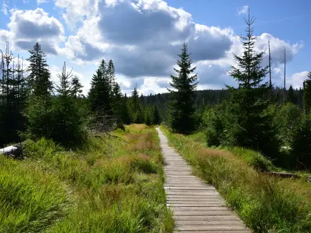
Lauwersmeer National Park Trail
How would you rate Lauwersmeer National Park Trail?
Tap a star to share your experience and help other hikers.
Lauwersmeer National Park Trail: Flat Day Walks, Birds and Dark Skies
HikeList Score
Lauwersmeer National Park Trail scored 70/100 on HikeList's trail-quality metrics.
See score breakdownHide breakdown
- Ideal length 55
- Balanced challenge 50
- Scenery & wildness 69
- Varied terrain 100
- Accommodation 75
- Food & support 75
- Path quality 98
- Season flexibility 63
Computed from length, challenge, scenery & wildness, terrain variety, accommodation, food & support, path quality and season flexibility.
The Lauwersmeer National Park Trail is best understood as a network of short, signed circular walks in the far north of the Netherlands, on the Groningen–Friesland border beside the Wadden Sea. A typical full-day combination is about 16 km, takes 1 day and is easy: flat, generally firm paths over reclaimed seabed, reed beds, grassland, woodland and dykes. It suits birdwatchers, relaxed day hikers and anyone wanting wide-open Dutch landscapes without serious ascent.
Route Overview
There is no single official 16 km named trail. Most walkers start from Activity Centre Lauwersnest at De Rug 1, Lauwersoog, or from Strandweg near Lauwersoog, Oostmahorn or Zoutkamp. Pick one or combine several circular routes: the white-marked Marneroute through Lauwersoogbos, Marnewaard and Marnebos; the Observatietorenroute with a dyke, forest and observation tower; or shorter options such as the Vogelroute, Konijnenroute, Orchideeenroute and Planetenpad. The wider Rondje Lauwersmeer is about 43 km and starts or finishes commonly at Zoutkamp. For other Dutch wetland and lowland walking, compare the Biesbosch National Park Trail, the Friese Woudenpad in neighbouring Friesland, the Drenthepad across the adjoining Drenthe heaths, and the Dutch Coastal Path (Hollands Kustpad).
From Lauwerszee to Lauwersmeer
Until 1969 this landscape was the Lauwerszee, a salt inlet of the Wadden Sea. On 25 May 1969 a dam closed it off from the sea, creating the freshwater Lauwersmeer. The exposed former seabed gradually developed into reed beds, grassland and young woodland, which now shape the walking routes. Lauwersmeer became a national park on 12 November 2003 and was certified as an International Dark Sky Park in 2016.
Notable highlights
- Dark Sky Park: Lauwersmeer is an International Dark Sky Park, certified in October 2016. On clear nights it is one of the better Dutch places for stargazing, with possible views of the Milky Way.
- Birdlife and hides: The park is known for breeding birds and migratory waterfowl, including geese, ducks, swans, spoonbill, bluethroat, bearded reedling and harriers. Observation towers and bird hides make it especially rewarding for slow walkers with binoculars.
- Lauwersmeer lake and reed beds: The freshwater lake was created when the old Lauwerszee was dammed off. Its reed beds, grasslands and open water give the routes their spacious, exposed character.
- Wild grazers: Konik horses and Scottish Highland cattle graze parts of the park, helping keep the grassland and marsh open. Give them space and stay on signed paths.
- Zoutkamp: This former fishing village on the southern edge of the park was once on the open sea and is now inland since the dam. It is a common start or finish for the longer Rondje Lauwersmeer.
- Marnewaard and woodlands: The Marneroute crosses young Lauwersoogbos and Marnebos woodland and part of the Marnewaard, showing how forest has grown on former seabed. This area closes during military exercises.
Challenges to expect
The walking is easy and effectively flat, but the exposure matters: long open stretches have little shade and few facilities, so carry water, sun protection and windproof layers. Some grass and marsh sections can be wet or muddy, especially in winter; boots are advised on routes such as the Vogelroute. Check local signs because the Marnewaard military training area closes during exercises, and some routes restrict dogs to protect wildlife.
HikeList Score
Lauwersmeer National Park Trail scored 70/100 on HikeList's trail-quality metrics.
See score breakdownHide breakdown
- Ideal length 55
- Balanced challenge 50
- Scenery & wildness 69
- Varied terrain 100
- Accommodation 75
- Food & support 75
- Path quality 98
- Season flexibility 63
Computed from length, challenge, scenery & wildness, terrain variety, accommodation, food & support, path quality and season flexibility.
 Netherlands
Show more data Show less
- Reclaimed Seabed
- Lake
- Reed Beds
- Grassland
- Salt Marsh
- Forest
- Dykes
- Firm Sand
- Gravel
- Grass Tracks
- Dyke Paths
- Marshy Sections
- Hotels
- Holiday Parks
- Campsites
- Family Friendly
- Pet Friendly
- Restrooms
- Campsites
- Picnic Areas
Photos from hikers
Taken on the trail by people who've reviewed Lauwersmeer National Park Trail.
Reviews
How would you rate Lauwersmeer National Park Trail?
Tap a star to start your review — you could be the first.