GR107 (Route des Bonshommes)
How would you rate GR107 (Route des Bonshommes)?
Tap a star to share your experience and help other hikers.
GR107 (Route des Bonshommes): Foix to Berga across the Cathar Pyrenees
HikeList Score
GR107 (Route des Bonshommes) scored 90/100 on HikeList's trail-quality metrics.
See score breakdownHide breakdown
- Ideal length 91
- Balanced challenge 80
- Scenery & wildness 98
- Varied terrain 71
- Accommodation 100
- Food & support 88
- Path quality 98
- Season flexibility 89
Computed from length, challenge, scenery & wildness, terrain variety, accommodation, food & support, path quality and season flexibility.
The GR107 (Route des Bonshommes) is a 225 km point-to-point GR trail from Foix in Ariège, France, across the eastern Pyrenees to Berga in Catalonia, Spain. Allow 10–13 days. It is a hard mountain thru-hike for fit walkers: expect long stages, sustained climbs, rocky passes and a high border crossing at the Portella Blanca d'Andorra. The draw is clear waymarking, Cathar history and a full north–south traverse from French forests and castles into the Catalan Pyrenees.
Route Overview
Most walkers hike north to south, starting in Foix beneath the Château de Foix and finishing at the Santuari de Queralt above Berga. The route passes Roquefixade, Montségur, Comus, Col du Chioula, Orgeix/Orlu, Mérens-les-Vals, Porta, the Portella Blanca d'Andorra, Bellver de Cerdanya, Bagà, Gósol and Rasos de Peguera. Bagà is a stage town, not the terminus. This is a waymarked red-and-white GR trail, though marking can be sparse on remote sections. If you are comparing French routes, see the Cirque de Gavarnie Trails, Chartreuse Trail (GR9 Segment) or Canal du Midi Towpath.
Cathars, bons homes and the Pyrenean escape route
The GR107 is named for the 'bons homes' — Cathar ascetic preachers considered heretical by the Catholic Church. During and after the Albigensian Crusade, Cathars in Languedoc were hunted by the Inquisition. Montségur, their stronghold and church seat from 1232, fell in March 1244; around 210 who refused to recant were burned. Survivors and later refugees used these Pyrenean passes to escape from Ariège into Catalonia. The same corridor also served for centuries as a trade and droving route.
Notable highlights
Château de Montségur: The symbolic heart of the GR107: a ruined Cathar mountain stronghold on a rocky pog. It fell in 1244 after a long siege, and its history gives the route much of its meaning.
Château de Roquefixade: A ruined Cathar-era castle on a high cliff facing Montségur. It is one of the first major landmarks after leaving Foix.
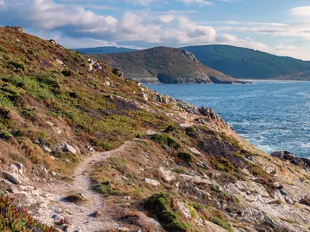
Gorges de la Frau: A narrow limestone gorge on the descent from Montségur towards Comus. The shaded passage and cliff walls make it one of the most distinctive natural sections of the French side.
Portella Blanca d'Andorra (~2,517 m): The highest point of the GR107 and the France–Spain–Andorra tripoint. It is a remote watershed crossing with no road access.
Gósol and Pedraforca: Gósol is a Pyrenean village beneath the Pedraforca massif, where Pablo Picasso spent the summer of 1906. The mountain dominates the skyline on this part of the Catalan section.
Santuari de Queralt: The cliff-perched sanctuary above Berga marks the Catalan trailhead and finish. It gives a clear end point after the final approach through the Berguedà.
Challenges to expect
The full GR107 is hard rather than beginner-friendly. Expect long days, sustained climbs, more than 11,000 m of total ascent, rocky high-mountain sections and a remote crossing at the Portella Blanca d'Andorra. Snow can linger early or late in the season, and late-summer thunderstorms are common. Accommodation exists, but some high refuges open only at weekends off-season, so book ahead in July–August when the trail is busiest.
HikeList Score
GR107 (Route des Bonshommes) scored 90/100 on HikeList's trail-quality metrics.
See score breakdownHide breakdown
- Ideal length 91
- Balanced challenge 80
- Scenery & wildness 98
- Varied terrain 71
- Accommodation 100
- Food & support 88
- Path quality 98
- Season flexibility 89
Computed from length, challenge, scenery & wildness, terrain variety, accommodation, food & support, path quality and season flexibility.
Show more data Show less
- Mountainous
- Forest
- Dirt
- Rocky
- Gravel
- Hotels
- Lodges
- Huts
- Campsites
- Hostels
- Family Friendly
- Pet Friendly
- Restrooms
- Water Sources
- Campsites
- Shelters
Download Our Full Guide to GR107 (Route des Bonshommes) FREE!
Get our comprehensive guide to this hike for free. Save it for later reading or print out at home.
In these collections
Photos from hikers
Taken on the trail by people who've reviewed GR107 (Route des Bonshommes).
GR107 (Route des Bonshommes): The Complete Guide
The GR107 — Route des Bonshommes is a serious cross-border Pyrenean traverse, linking Foix in the Ariège with Berga and the Santuari de Queralt in Catalonia. It follows a historic Cathar line south through castles, gorges, beech forest, high pasture and mountain villages before crossing the main range into Spain.
The route has a strong sense of progression: Château de Foix, Roquefixade and Montségur give the early days their Cathar-country character, while the Gorges de la Frau and Col du Chioula move the walk steadily into higher terrain. Beyond Mérens-les-Vals and Porta, the Portella Blanca d'Andorra is the decisive crossing — a remote, road-less col at about 2,517 m on the France–Andorra–Spain tripoint.
South of the watershed, the walk changes character again through the Catalan Cerdanya, Cadí-Moixeró Natural Park, Bagà, Gósol and the Pedraforca country. The finish at the Santuari de Queralt above Berga is not just a ceremonial endpoint: it is a final climb to a cliff-perched sanctuary at about 1,200 m.
This is a route for fit, experienced walkers rather than a first long-distance hike. Expect long days, roughly 11,000–11,600 m of total ascent, rocky high-mountain sections, changeable weather, possible snow at the season’s edges and accommodation spacing that demands advance planning.
This guide covers stages, daily planning, accommodation, food, transport, terrain, seasonality and the common mistakes that can make the GR107 harder than it needs to be.
Stage-by-Stage Guide
The stage notes below follow the north-to-south Foix to Berga direction used by most walkers. Distances are approximate and should not be treated as a substitute for the official map, guidebook or GPX track, especially where variants affect the line.
Accommodation, meals and refuge opening periods must be checked before committing to each day. Several endpoints are small mountain villages or refuges rather than full-service towns, and the high stages leave little room for improvising if a bed or evening meal is unavailable.
Stage 1: Foix to Roquefixade — approx. 20 km
The route starts at the foot of the Château de Foix, with GR red-and-white waymarks leading out of town into the Ariège countryside. This first day is not yet high Pyrenees, but it is already a proper walking stage, moving from the town into forest, field paths and higher ground towards the limestone ridges of Cathar country.
The key landmark is the transition from Foix’s castle setting to the approach to Roquefixade, whose ruined Cathar-era castle sits on a cliff edge facing towards Montségur. Expect a mix of dirt paths, rural tracks and some lane sections rather than a continuous mountain path.
Foix is the best place to buy food before starting, as it is the only confirmed full-service town at this end of the route and has its own SNCF station. Do not assume reliable intermediate resupply on the day; carry lunch and enough water from the start.
Roquefixade is a small end point, so accommodation and evening food should be booked ahead. Road access exists to the village area, but public transport options for joining or leaving here are not specified; this should be checked before travelling.
Navigation should be straightforward in normal conditions if following the GR waymarks, but the first day is where walkers often need to settle into the signage style. Keep the map or GPX accessible leaving Foix and again around paths, lanes and village approaches, where waymarks can be easier to miss than on open mountain ground.
Stage 2: Roquefixade to Montségur — approx. 17 km
This stage continues through the Cathar-country landscape towards one of the defining places on the GR107: Montségur. The walking remains a mixture of wooded paths, ridges, tracks and village approaches, with the ruined castles of Roquefixade and Montségur giving the day its main historic focus.
The approach to Montségur is dominated by the rocky “pog” of the Château de Montségur. The castle is the symbolic heart of the route, associated with the siege that ended in March 1244 and the execution of around 220 Cathars below the walls.
Food and water planning should remain conservative. Roquefixade and Montségur are not described as major resupply towns in the route information, so walkers should carry a full day’s food unless accommodation arrangements include packed lunch or meals. This should be checked before travelling.
Montségur is a common focal point for walkers, including those starting the shorter credential version of the Camí dels Bons Homes from the château area rather than Foix. Accommodation should still be reserved, particularly in the main summer walking window.
Navigation is generally on the GR, but the terrain around ridges, castle approaches and village paths can include short, steeper or rockier sections. In poor visibility, do not rely only on sighting the next landmark; use the map and GPS track to stay on the GR107 line.
Stage 3: Montségur to Comus — approx. 16 km
This is one of the most distinctive French-side stages because it threads the Gorges de la Frau on the way towards Comus. The gorge is a limestone canyon cut by the Hers river, with cliffs rising roughly 300–400 m, and it gives the stage a much more enclosed, dramatic feel than the open castle-country walking before it.
Underfoot, expect rocky path through the gorge environment, plus forest and mountain tracks as the route leaves the Montségur plateau and works towards Comus. The day is not especially long on paper, but the terrain is more serious than a simple valley walk.
Carry food from Montségur unless a packed lunch has been arranged. Water availability in the gorge and on the approach should not be assumed without current local information, so start with enough for the day.
Comus is a small mountain village, so accommodation and dinner should be arranged in advance. Road access exists to the village, but public transport connections are not a planning certainty; this should be checked before travelling.
The gorge section deserves particular attention in wet weather, when rocky or shaded ground may be slippery. It is also a place where concentrating on the path matters more than rushing the stage, as the canyon terrain is less forgiving than the gentler lanes and fields of the opening days.
Stage 4: Comus to Refuge du Chioula — approx. 14 km
From Comus the route climbs into a more upland Ariège setting, moving through beech forest and high pasture towards the Col du Chioula area. Although this is one of the shorter listed stages, it gains height and begins to feel more like the approach to the high Pyrenees.
The Col du Chioula is the main landmark of the day. It is a wooded pass with a gîte/refuge and forms a natural staging point before the route drops towards the Ax-les-Thermes valley system.
Food and water depend heavily on what is available at the start and at Refuge du Chioula. Do not count on shops or cafés en route unless current information specifically confirms them; carry lunch and confirm whether the refuge provides evening meals, breakfast and packed lunches.
Accommodation is at or around Refuge du Chioula. Refuge opening periods can vary, and some high refuges on this route may open only at weekends outside the main season, so this stage should not be attempted on the assumption that a bed will be available on arrival.
Navigation is generally by GR waymarks through forest, pasture and pass country. In mist, wooded tracks and open grazing areas can make it harder to judge direction, so map and GPX checks are sensible before leaving Comus and again before the final approach to the refuge.
Seasonal conditions begin to matter more from here. Early or late in the season, lingering snow and cold weather can affect higher ground, while late-summer thunderstorms can build quickly over the passes.
Stage 5: Refuge du Chioula to Orgeix / Orlu — approx. 11 km
This is a shorter transitional stage from the Col du Chioula area down towards the Orgeix / Orlu valley area. The walking shifts from pass and upland terrain into lower approaches, with forest, tracks and some rural access likely to feature more than exposed high mountain ground.
The main purpose of the day is logistical as much as scenic: it positions walkers for the next stage towards Mérens-les-Vals and the main Pyrenean watershed beyond. Ax-les-Thermes is near this section as a variant access point and is important because it has a railway station on the Toulouse–Latour-de-Carol line.
Food and water should still be planned before leaving the refuge. Confirm breakfast, packed lunch and water at Refuge du Chioula, and check what services are available at the chosen end point, whether Orgeix, Orlu or nearby access via Ax-les-Thermes.
Accommodation is possible in the wider Orgeix / Orlu area, but the precise choice affects the next day’s walking and any transfer needs. Book ahead and be clear whether the accommodation is directly on the walking line or requires a short diversion.
For public transport, Ax-les-Thermes is the known useful rail access near this part of the route. Local road connections between Orgeix, Orlu and Ax-les-Thermes should be checked before travelling.
Navigation is likely to be less complex than the highest stages, but valley approaches can involve tracks, lanes and settlement edges where it is easy to leave the GR accidentally. This is a good stage to make sure the next two days are fully prepared, because the route soon becomes more remote.
Stage 6: Orgeix / Orlu to Mérens-les-Vals — approx. 18 km
This stage links the Orgeix / Orlu area with Mérens-les-Vals, one of the key French-side transport points on the route. The terrain becomes more mountainous again as the GR works south towards the upper Ariège and the approach to the high border crossing.
Expect a full mountain walking day with forest, tracks and rougher path sections rather than a simple valley transfer. The stage is also important for resupply and access, because Mérens-les-Vals has a railway station on the Toulouse–Latour-de-Carol line.
Food planning depends on the services available at the previous night’s accommodation and in Mérens-les-Vals. Carry a full day’s supplies unless packed lunch has been arranged, and use Mérens-les-Vals as a practical point to reset food, fuel and weather plans before the route continues to Porta and the Portella Blanca d’Andorra.
Accommodation at Mérens-les-Vals should be booked ahead. Its rail access makes it one of the more useful places for joining, leaving or taking a rest day on the French side.
Navigation should be managed carefully where the route passes through valley settlements or track networks. The red-and-white GR waymarks remain the main guide, but this is not terrain where a phone-only plan should be the sole backup.
From this point south, weather and snow conditions become increasingly important. Check the forecast and high-pass conditions before continuing, especially outside the settled mid-summer window.
Stage 7: Mérens-les-Vals to Porta — approx. 22 km
This is a longer French-side mountain stage leading towards Porta, the last listed settlement before the route crosses the main watershed. It is a serious walking day in its own right and should not be treated merely as an approach to the border crossing.
The terrain is high and mountainous, with sustained climbs, rocky paths and more remote ground than on the early Ariège stages. It forms part of the build-up to the Portella Blanca d’Andorra, so the weather, snowline and the walker’s condition should all be assessed before leaving Mérens-les-Vals.
Mérens-les-Vals is the key confirmed service and railway point before this section. Carry enough food and water for the full stage, and do not rely on significant intermediate resupply unless current local information confirms it.
Porta is the end point and the practical base before the border stage. Accommodation and meals here should be reserved in advance; arriving without a booking is a poor strategy given the remoteness of the next day.
Public transport information for Porta is not specified in the route facts, even though the broader valley has rail access at Mérens-les-Vals and Ax-les-Thermes. Any plan to start, stop or divert at Porta should be checked before travelling.
Navigation needs to be disciplined. If cloud drops or storms threaten, this is not a place to continue casually; use the GR waymarks in combination with map and GPX, and be prepared to stop short or change plans if conditions deteriorate.
Stage 8: Porta to Bellver de Cerdanya over the Portella Blanca d’Andorra — approx. 23 km
This is the crux stage of the GR107. The route crosses the Portella Blanca d’Andorra, the high point of the trail at about 2,517 m and the road-less Andorra–Spain–France tripoint, before descending into the Catalan Cerdanya towards Bellver de Cerdanya.
The crossing is remote, high and exposed, with no road access and no facilities at the col. Treat it as a self-sufficient mountain day: start early, carry sufficient food and water, have warm and waterproof layers accessible, and do not commit to the crossing in poor visibility, thunderstorms or unsafe snow conditions.
Terrain is rocky high-Pyrenean path and watershed country on the ascent and crossing, followed by the descent into Catalonia. Snow can linger here at the edges of the season, and winter conditions make this part of the route unsuitable for normal hiking.
Porta is the last practical overnight point before the col, so confirm breakfast, packed lunch and water before leaving. Bellver de Cerdanya is the first listed Catalan town after the crossing and should be treated as the next proper recovery and logistics point.
Accommodation in Bellver de Cerdanya should be booked ahead, particularly in July and August. The Catalan side of the trail is signed as GR-107 / Camí dels Bons Homes, so expect the naming on signs and local information to shift after the border.
Navigation is critical on this stage. The GR is waymarked, but high cols, snow patches, cloud and broad open ground can make waymark-to-waymark travel unreliable; carry the official map or guidebook and the GPX track, and know how to use them.
Stage 9: Bellver de Cerdanya to Bagà — approx. 22 km
From Bellver de Cerdanya the route enters the Catalan mountain half of the GR107, moving towards Bagà and the Cadí-Moixeró Natural Park. This is a substantial stage through protected mountain country rather than an easy lowland day.
The terrain is likely to mix mountain paths, forest tracks, rural lanes and rougher upland sections. The main transition is from the open Cerdanya side into the Cadí-Moixeró landscape that shapes the southern half of the route.
Bellver de Cerdanya is the best place to organise food before leaving. Carry lunch and water for the full day unless current services on the route are known, as reliable intermediate resupply is not specified.
Bagà is an important overnight stop and the location of the Cadí-Moixeró Natural Park regulatory council’s seat and visitor centre. It is a useful place to check park information, weather and onward trail conditions before the next stage towards Gósol.
Accommodation in Bagà should be reserved in advance. Road access exists to the town, but specific public transport links for walkers are not given here; this should be checked before travelling.
Navigation remains on the GR-107 / Camí dels Bons Homes. In forested and track-heavy terrain, pay attention at junctions, as the challenge is often choosing the correct track rather than following an obvious single footpath.
Stage 10: Bagà to Gósol — approx. 25 km
This is one of the longer Catalan stages and crosses demanding mountain country between Bagà and Gósol. It passes through the wider Cadí-Moixeró and Pedraforca region, so expect a serious day with significant ascent and descent rather than a simple village-to-village walk.
The highlight is the approach to Gósol beneath the distinctive twin-pronged Pedraforca massif, which rises to 2,497 m. Gósol is also notable for its Picasso connection: he spent the summer of 1906 there, and the village’s Centre Picasso commemorates that period.
Because of the length, leave Bagà with a full day’s food and enough water. Do not rely on finding shops or cafés en route unless this has been checked locally; the mountain setting and distance make self-sufficiency important.
Gósol is the overnight objective and a key rest and resupply point before the final two stages towards Rasos de Peguera and Berga. Accommodation should be booked, especially in the busy summer period.
Public transport or road access for Gósol is not specified in the route facts. Any plan to join, leave or send baggage from here should be checked before travelling.
Navigation can be demanding in poor weather because the stage is long and mountainous. Start early, keep the map and GPX available, and treat thunderstorms seriously; late-summer storms are a known concern on the high Pyrenean sections of the route.
Stage 11: Gósol to Rasos de Peguera / Peguera — approx. 18 km
This stage continues south-west through the Pedraforca and Berguedà mountain country towards Rasos de Peguera / Peguera. It is shorter than the Bagà to Gósol day but still sits in sustained mountain terrain, so it requires the same level of preparation.
Expect a mix of mountain paths, forest tracks, high pasture and rural access routes. The walking is less about a single landmark and more about linking the Gósol area with the final approach to Berga.
Food and water should be arranged before leaving Gósol. Rasos de Peguera / Peguera is not described as a full-service town, so confirm accommodation, meals and water at the end point before starting the stage.
Accommodation choices in this area can be more limited and more seasonal than in larger towns. Book ahead and check exactly where the accommodation lies in relation to the GR-107, as a small location difference can matter at the end of a mountain day.
Public transport details are not specified for Rasos de Peguera / Peguera. This should be checked before travelling, particularly if using this stage as a section-hike start or finish.
Navigation should be treated carefully through forest, pasture and track junctions. In mist or stormy weather, do not rely on distant views towards the next settlement; follow the waymarks and check the route at every unclear junction.
Stage 12: Rasos de Peguera / Peguera to Berga and the Santuari de Queralt — approx. 12 km
The final stage descends towards Berga and then finishes at the Santuari de Queralt, the cliff-perched sanctuary above the town. Although the listed distance is shorter, the finish is not simply a town-centre arrival: the sanctuary sits at about 1,200 m and is around 4 km above Berga by the BV-4141 road or marked paths.
The terrain combines the last mountain paths and access routes into Berga with the final climb to the Santuari de la Mare de Déu de Queralt. The sanctuary, built between 1725 and 1741 and known as the “Balcony of Catalonia”, provides the formal Catalan trailhead and a clear end point for the GR107.
Carry food and water from Rasos de Peguera / Peguera unless breakfast and supplies are certain. Berga is the first listed town at the end of the route, but the climb to Queralt should still be treated as part of the walking day rather than an optional afterthought if completing the full route.
Accommodation is available in or around Berga rather than necessarily at the sanctuary itself. Book ahead if arriving in high season or late in the day, and allow time either to descend from Queralt or arrange onward logistics.
Berga has no railway station. The main onward public transport option is by ALSA coach to Barcelona from Estació d’Autobusos Barcelona Nord, with a typical journey time of roughly 1.5–2 hours; current timetables should be checked before travelling.
Navigation is normally easier near a major town, but the final section can still involve a choice between road access and marked paths to Queralt. Follow the GR-107 / Camí dels Bons Homes signs to the sanctuary if completing the official finish, and avoid ending in Berga town prematurely unless that is the planned stopping point.
Recommended Itinerary
The most practical north-to-south schedule for most fit walkers is a 12-day itinerary from Foix to the Santuari de Queralt above Berga. It follows the stage pattern closely, keeps the high Portella Blanca d'Andorra crossing as its own major day, and avoids compressing the remote Pyrenean section too aggressively.
Distances are approximate. Accommodation, refuge opening dates, meals and transfer options should be checked before travelling, especially outside July-August and on the high stages.
Standard 12-day itinerary
| Day | From | To | Approx. distance | Why this stage makes sense | Services/accommodation notes |
|---|---|---|---|---|---|
| 1 | Foix | Roquefixade | 20 km | A full but manageable first day leaving the railway town of Foix and moving into the Cathar foothills. Roquefixade makes a logical first overnight before the Montségur stage. | Foix has an SNCF station and is the easiest place to organise arrival supplies. Roquefixade accommodation should be booked ahead rather than assumed on arrival. |
| 2 | Roquefixade | Montségur | 17 km | A shorter day with major historic interest, finishing at the key Cathar landmark of Montségur. The distance helps after the opening day and before the more enclosed terrain towards Comus. | Montségur is an important overnight stop on the route and is also where some shorter credential itineraries begin. Book ahead in the walking season. |
| 3 | Montségur | Comus | 16 km | A deliberately moderate stage, useful because the route passes through the Gorges de la Frau, one of the more distinctive natural sections on the French side. | Services are limited in this part of the Ariège. Carry what is needed for the day and check evening meal arrangements when booking accommodation. |
| 4 | Comus | Refuge du Chioula | 14 km | Short on paper, but it gains height towards the Col du Chioula area and is better treated as a mountain approach day rather than an easy half-day. | Refuge du Chioula is the key overnight point here. Opening dates and meal availability should be checked before travelling, particularly off-season. |
| 5 | Refuge du Chioula | Orgeix / Orlu | 11 km | A shorter linking stage dropping towards the Ax-les-Thermes valley area, giving useful recovery before the longer approach to Mérens-les-Vals. | Orgeix and Orlu are the overnight options given for this stage. Ax-les-Thermes is a nearby variant access point with rail connections, but route and transfer details should be checked before relying on it. |
| 6 | Orgeix / Orlu | Mérens-les-Vals | 18 km | This sets up the high-Pyrenean section without making the previous day too long. Mérens-les-Vals is a sensible staging point before the push towards Porta. | Mérens-les-Vals is on the Toulouse–Latour-de-Carol railway line, making it a useful access or exit point. Accommodation and food should still be booked or checked ahead. |
| 7 | Mérens-les-Vals | Porta | 22 km | A serious mountain approach day, positioning the next stage for the Portella Blanca d'Andorra crossing. Do not underestimate this section just because the border col comes the following day. | Porta is the key overnight before the watershed crossing. Confirm lodging, meals and next-day weather before leaving Mérens-les-Vals or Porta. |
| 8 | Porta | Bellver de Cerdanya, over the Portella Blanca d'Andorra | 23 km | This is the crux stage of the standard itinerary: the route crosses the remote, road-less Portella Blanca d'Andorra at about 2,517 m and enters the Catalan Cerdanya. It needs a clear weather window and an early start. | There are no facilities at the border col. Carry food, water, warm layers and navigation, and check snow and thunderstorm risk before committing. Bellver de Cerdanya is the first major Catalan overnight in this schedule. |
| 9 | Bellver de Cerdanya | Bagà | 22 km | A substantial Catalan mountain day through the Cadí-Moixeró area, linking the Cerdanya with Bagà. The distance is long enough to be tiring after the border crossing, so avoid a late start. | Bagà is an important service point on the southern half and has the Cadí-Moixeró Natural Park visitor centre. Book accommodation ahead in peak season. |
| 10 | Bagà | Gósol | 25 km | One of the longer standard stages, crossing into the Pedraforca country and finishing in Gósol. It suits fit walkers but should not be treated as a casual village-to-village day. | Gósol is the logical overnight beneath the Pedraforca area. Secure accommodation in advance and check whether meals are available where staying. |
| 11 | Gósol | Rasos de Peguera / Peguera | 18 km | A shorter but still mountainous penultimate stage, keeping the final approach to Berga and Queralt manageable. | Services and accommodation around Rasos de Peguera / Peguera are less straightforward than in the larger towns. This night should be fixed before starting the route. |
| 12 | Rasos de Peguera / Peguera | Berga and Santuari de Queralt | 12 km | A short final walking day, allowing time to finish properly at the Santuari de Queralt above Berga rather than stopping in the town. | The Santuari de Queralt is about 4 km above Berga by road or marked paths, with roughly a 30-45 minute climb from town. Berga has no railway; onward travel is by coach, including ALSA services to Barcelona. |
Slower variant: 13 days
A 13-day plan suits walkers who want more margin for weather, recovery and logistics rather than simply shorter daily distances. The most useful extra day is a buffer before or after the high crossing: Mérens-les-Vals, Porta, Bellver de Cerdanya or Bagà are the most practical places in the stage sequence to build in that margin.
This is especially sensible in early summer or autumn, when snow on the Portella Blanca d'Andorra or thunderstorms can make the border stage unsafe on a fixed day. If following an official 13-stage split rather than adding a rest or weather day, check official mapping and accommodation before booking, as stage distances and stopping places vary by source.
Faster variant: 10 days
A 10-day schedule is for very fit, mountain-experienced walkers who are comfortable with repeated long days and little recovery time. It normally means combining some of the shorter northern or final stages, while keeping the Porta to Bellver de Cerdanya crossing over the Portella Blanca d'Andorra as a standalone mountain day.
Do not compress the itinerary by turning the border crossing into part of an even longer stage unless conditions, daylight and fitness are excellent. The route has around 11,000 m or more of ascent overall, and a fast schedule leaves little margin for storms, snow patches, accommodation issues or fatigue.
Choosing the right pace
Most independent walkers should start planning around the 12-day itinerary, then add a buffer if travelling outside the most settled summer window. Faster schedules work best for hikers carrying light packs, with all accommodation booked and escape options understood.
The high and remote stages dictate the itinerary more than the village distances do. Prioritise secure overnight stops at Refuge du Chioula, Porta, Bellver de Cerdanya and the Rasos de Peguera / Peguera area, then adjust the easier-access sections around those bookings.
Planning the Route
How many days to allow
Most walkers should plan the GR107 as a 12- or 13-day traverse, not as a fast 10-day push. The route has long climbs, uneven mountain ground and several stages where accommodation spacing is dictated by valleys, passes and refuges rather than by ideal daily mileage.
A 10-day itinerary is realistic only for very fit walkers who are comfortable joining stages, starting early and carrying enough food and bad-weather kit for long mountain days. For most independent hikers, the safer plan is to keep the standard stage pattern, add a little margin around the high Pyrenean crossing, and avoid arriving at remote accommodation late.
The critical planning point is the Porta to Bellver de Cerdanya stage over the Portella Blanca d'Andorra. This is the high, road-less watershed crossing and should not be treated as an ordinary transfer between villages: it needs a stable weather forecast, an early start and enough food, water and clothing to be self-sufficient.
Stage planning and accommodation spacing
Daily stages are shaped mainly by where it is practical to sleep. The chain of gîtes d'étape, refuges/refugis, small hotels, hostels, guesthouses and campsites/bivouac spots makes the route walkable, but the high and remote sections do not give unlimited flexibility.
Book accommodation ahead, especially in July and August. Outside the main summer season, some high refuges may open only at weekends or have limited availability, so opening dates and meal arrangements should be checked before travelling.
A practical planning pattern is:
| Route section | Planning implication |
|---|---|
| Foix to Montségur | Easier to organise around villages, but still with meaningful climbs from the start. |
| Montségur to Comus via the Gorges de la Frau | Keep the day realistic; the canyon and limestone terrain make this more than a simple lowland stage. |
| Comus to Col du Chioula / Refuge du Chioula | Accommodation and refuge availability matter; do not assume off-season services. |
| Col du Chioula to Orgeix / Orlu and Mérens-les-Vals | Useful middle section before the high crossing; Ax-les-Thermes and Mérens-les-Vals give railway access on or near the route. |
| Mérens-les-Vals to Porta | Set up carefully for the following day over the Portella Blanca d'Andorra. |
| Porta to Bellver de Cerdanya | The main high-mountain commitment of the route: no road access at the col and no facilities at the top. |
| Bellver de Cerdanya to Bagà, Gósol and Berga | Still strenuous, with mountain terrain through the Cadí-Moixeró and Pedraforca country; do not underestimate the southern stages. |
Fast, steady or slower itineraries
A steady 12-day itinerary matches the natural rhythm of the route well and avoids forcing too many long days back to back. A 13-day plan is better if accommodation availability, weather or personal pace make the high stages awkward.
Walking more slowly can be worthwhile where it reduces pressure around the border crossing or avoids arriving at refuges late. It also gives more room to deal with afternoon thunderstorms, which are a real consideration in late summer.
A fast itinerary should only be planned if every long day still leaves enough time for weather delays and navigation. Compressing the route can turn manageable mountain stages into days with little margin for mistakes.
Shortening, extending and variants
The main thru-hike is normally planned north to south from Foix to Berga, finishing at the Santuari de Queralt above Berga. The shorter pilgrim credential version of the Camí dels Bons Homes is often counted from Château de Montségur rather than Foix, which explains why some itineraries quote a shorter route.
There are also recognised variants around Mérens-les-Vals, Ax-les-Thermes and Guils de Cerdanya, with GPX files available from the official GR107 site. Use these deliberately rather than improvising: variants can affect stage length, transport access and accommodation bookings.
Extending the route is not usually the main issue; the GR107 already has enough ascent and remote terrain for a serious multi-day crossing. If adding extra days, it is usually more useful to build in weather or rest margin than to add distance.
Section hiking
Section hiking is practical on the French side because Foix, Ax-les-Thermes and Mérens-les-Vals are on the Toulouse–Latour-de-Carol railway line. This makes it easier to start, pause or leave the route in the Ariège section.
The Spanish end is less rail-connected. Berga has no railway, so access is by coach from Barcelona, and the final climb to the Santuari de Queralt sits above the town. Current train and ALSA coach times should be checked before travelling.
For a shorter high-level section, the area between Mérens-les-Vals, Porta and Bellver de Cerdanya is the most serious part logistically because it includes the Portella Blanca d'Andorra. It should not be planned as a casual weekend link unless accommodation, weather and return transport are all in place.
Food, water and daily self-sufficiency
Food planning should be done stage by stage. The route passes through villages and mountain accommodation, but services are not evenly spaced, and the remote high stages leave little room for relying on last-minute purchases.
When booking gîtes and refuges, check whether dinner, breakfast and packed lunches are available. If meals are not included, carry enough food for the next stage before leaving the previous settlement.
Water should be treated conservatively. Do not rely on unplanned water points on high ground, especially on exposed passes and long forest or pasture sections. Carry enough for the full day unless a reliable source has been identified in advance.
Navigation and route information
The GR107 is waymarked with red-and-white GR balisage, signed as GR107 in France and GR-107 / Camí dels Bons Homes in Catalonia. Waymarking reduces but does not remove the need for navigation, particularly in poor visibility, forest junctions, snow patches or storm conditions.
Carry offline mapping and the official GPX tracks, plus either the IGN topo-guide or the Cicerone guidebook. The official GR107 site provides GPX downloads for the Foix–Porta and Porta–Berga sections and the recognised variants.
The Portella Blanca d'Andorra deserves particular care. It is a remote border col at around 2,517 m, with no road access and no facilities at the top, so a phone map alone is not an adequate navigation plan.
Weather, snow and timing
Plan the route for the snow-free mountain season, broadly June to September/October, with the most reliable conditions in summer. The high passes can hold snow at the shoulders of the season, and winter makes the high stages impassable for normal hiking.
Late-summer thunderstorms are a practical scheduling issue. Start early on exposed mountain days, avoid committing to high cols in unstable weather, and keep enough flexibility in the itinerary to wait if the forecast is poor.
Before setting out, check current snow conditions, refuge opening dates, transport times and the local mountain forecast. On this route, those details matter more than squeezing the itinerary into the fewest possible days.
Towns, Villages and Overnight Stops
Accommodation on the GR107 is a mix of gîtes d’étape, mountain refuges/refugis, small hotels, hostels, guesthouses and occasional campsites or bivouac spots in the valley villages. The chain is workable for an independent thru-hike, but spacing is controlled by the terrain rather than by convenient towns, so the high and remote stages need advance planning.
Book ahead in July and August, and check opening dates outside the main summer season. Some high refuges may open only at weekends off-season, and the Porta to Cerdanya crossing over the Portella Blanca d’Andorra has no services at the pass.
Foix
Foix is the standard northern trailhead, with the GR red-and-white waymarks leading out from the foot of the Château de Foix. It is the easiest place on the French side to organise the start of the walk, sort last-minute food and stay the night before setting off.
The town has its own SNCF railway station on the Toulouse–Latour-de-Carol line, with Toulouse-Matabiau around an hour away by train. This makes Foix the most straightforward public-transport access point for a north-to-south itinerary.
Accommodation and food options are better here than in the smaller villages ahead, so it is sensible to arrive with reservations for the first few nights already made. Do not rely on being able to solve accommodation problems casually once beyond Foix, especially in peak season.
Roquefixade
Roquefixade is the first normal overnight stop south of Foix, after a stage of around 20 km. It sits beneath the ruined Château de Roquefixade, one of the early landmark sites on the route.
This is a village stop rather than a large service centre. Expect limited accommodation and food options compared with Foix, and arrange the night’s lodging and meals before arriving.
There is no specific transport link supplied for Roquefixade, so it should be treated primarily as an on-foot stage stop. Any taxi, bus or local transfer options should be checked before travelling.
Montségur
Montségur is a key overnight stop and one of the most important places on the whole GR107. It sits around the symbolic Cathar stronghold of the Château de Montségur, and it is also where some versions of the shorter pilgrim credential route are counted from rather than from Foix.
For walkers starting in Foix, Montségur usually comes at the end of the second stage. Accommodation should be booked ahead, as it is an obvious stopping point and a focal place on the route.
Food and shop availability should not be assumed without checking current opening times. If staying here before the stage towards Comus and the Gorges de la Frau, make sure the next day’s provisions are sorted in advance.
Comus
Comus is the practical stop after the Montségur plateau and the passage through or around the Gorges de la Frau area. It is a small mountain village, useful because of its position rather than because of a wide range of services.
Accommodation availability is likely to be limited and should be reserved in advance. Meal arrangements matter here: check whether the accommodation provides dinner and breakfast, and carry food if onward services are uncertain.
Comus is also a point where the route starts to feel more mountain-based. Weather, footwear and pack weight become increasingly important from here towards the Col du Chioula and the higher Ariège stages.
Col du Chioula / Refuge du Chioula
The Col du Chioula is a high early-stage stop on the French side, with the Refuge du Chioula acting as the natural overnight point. It is reached after the stage from Comus and comes before the descent towards the Ax-les-Thermes valley area.
This is not a town stop. Treat it as a refuge night: book ahead, check whether it is staffed, confirm meals and opening dates, and do not assume there will be shops or alternative accommodation nearby.
Off-season availability is especially important to verify, as high refuges on this route may have restricted opening. This should be checked before travelling.
Ax-les-Thermes
Ax-les-Thermes is near the route and is noted as a variant access point rather than the main line for every itinerary. It is useful because it has an SNCF railway station on the Toulouse–Latour-de-Carol line.
For section-hikers, bail-outs or rest logistics, Ax-les-Thermes can be one of the most practical transport points on the French side. It can help break or rejoin the route around the Chioula, Orgeix and Orlu section, depending on the chosen variant.
Any local transfer between the GR107 line and Ax-les-Thermes should be checked before relying on it. Do not assume a convenient same-day bus or taxi without arranging it in advance.
Orgeix
Orgeix is one of the route’s practical valley stops after the Col du Chioula section. The stage information groups this area as Orgeix / Orlu, so walkers may need to choose accommodation according to availability and the exact line being followed.
This is a useful overnight area because it keeps the itinerary on schedule before the next stage towards Mérens-les-Vals. Accommodation and meals should be confirmed before arrival, particularly if staying outside the main summer window.
There is no specific rail link supplied for Orgeix. If using it as an access or exit point rather than simply walking through, onward transport should be checked before travelling.
Orlu
Orlu is the paired alternative to Orgeix for the overnight after Refuge du Chioula. It works as a stage stop before continuing towards Mérens-les-Vals.
As with Orgeix, plan this as a small mountain-village stop. Book accommodation ahead, check whether dinner is available, and carry enough food if shop opening is uncertain.
The exact choice between Orgeix and Orlu will depend on the itinerary, accommodation availability and any variant being followed. This should be settled before the day begins rather than left to chance late in the stage.
Mérens-les-Vals
Mérens-les-Vals is a major practical point on the French half of the GR107 because it lies on the route and has an SNCF railway station on the Toulouse–Latour-de-Carol line. It is the best-supported transport point between the Foix/Ax area and the high border approach.
It is a sensible overnight stop before the stage to Porta. For section-hikers, it is also a logical place to leave or rejoin the walk.
Because the route south of here moves towards the remote Portella Blanca d’Andorra crossing, use Mérens-les-Vals to reset logistics: check the weather, confirm the next accommodation, and ensure food and mountain kit are adequate. Train times should be checked before travelling.
Porta
Porta is the last French-side settlement before the high crossing to the Catalan Cerdanya over the Portella Blanca d’Andorra. It is therefore a critical overnight and preparation stop, even if services are limited.
The next stage is one of the most serious on the route: a road-less border crossing with no facilities at the col. Accommodation, meals and onward plans from Porta should be arranged in advance.
Do not leave Porta without a settled weather forecast, enough food and water for the day, and confidence in snow conditions. Early or late in the season, the high pass can still be hazardous or blocked.
Portella Blanca d’Andorra
The Portella Blanca d’Andorra is not an overnight stop and has no facilities. It is the high, road-less border col where France, Spain and Andorra meet, and it marks the crossing from the French side into the Catalan Cerdanya.
There is no accommodation, food, road access or shelter to rely on at the pass. The practical overnight planning is therefore done either side of it, typically using Porta on the French side and a Cerdanya stop beyond the crossing.
This stage must be treated as self-sufficient mountain travel. Check snow and thunderstorm risk before committing, and do not plan the day around buying food, finding transport or arranging help at the col.
Guils de Cerdanya
Guils de Cerdanya is listed as a variant on the Catalan side rather than the core stop for every itinerary. It may be relevant depending on the exact GPX track, guidebook stage split or local variant being followed.
Because it is a variant, do not build an itinerary around services here without checking current accommodation, food and transport options. This should be checked before travelling.
For most walkers, the key practical aim after the Portella Blanca crossing is to reach a confirmed overnight stop in the Cerdanya. Make sure the chosen line and booked accommodation match the same route variant.
Bellver de Cerdanya
Bellver de Cerdanya is the main Catalan Cerdanya overnight stop after the crossing from Porta over the Portella Blanca d’Andorra. It is a significant planning point because it comes immediately after one of the route’s most remote stages.
Use Bellver de Cerdanya as a recovery and reorganisation stop before entering the Cadí-Moixeró stages towards Bagà. Accommodation should still be booked ahead, but this is one of the more important service points on the southern half.
Food, meals and any onward local transport should be checked locally or before arrival. If the high crossing has been delayed by weather, Bellver is a logical place to adjust the onward schedule.
Bagà
Bagà is a key Catalan-side stop between Bellver de Cerdanya and Gósol. It is also the location of the Cadí-Moixeró Natural Park regulatory council’s seat and visitor centre, making it useful for information on the protected massif the route crosses.
It is a good overnight stop before the long stage towards Gósol. Accommodation should be reserved in advance, particularly in the main walking season.
Bagà is the place to take local conditions seriously before continuing into the Pedraforca country. Check weather, route conditions and any practical park information before leaving town.
Gósol
Gósol is the main stop beneath the Pedraforca area and one of the strongest overnight points on the southern stages. The village is associated with Pablo Picasso’s 1906 stay and has the Centre Picasso, but for walkers its main value is its position before the final Berguedà stages.
The stage from Bagà to Gósol is long, so arriving with accommodation already booked is sensible. Confirm meals and breakfast, especially if starting early the next day towards Rasos de Peguera or Peguera.
Gósol is also a useful place to reassess fatigue. The route is nearing the finish, but the final stages still involve mountain terrain and should not be treated as a simple lowland walk.
Rasos de Peguera / Peguera
Rasos de Peguera / Peguera is the final overnight area before Berga and the Santuari de Queralt. It is a strategic stop that keeps the last day short enough to include the finish above Berga.
Services here should be treated as limited unless specifically confirmed. Book accommodation ahead, check meal availability, and do not assume shops or cafés will be open when needed.
Because this is the penultimate stop, it can be tempting to relax planning too early. Keep enough food for the final stage into Berga and the climb to the sanctuary if services are closed or timing is awkward.
Berga
Berga is the main town at the southern end of the route and the practical finishing base for most walkers. The GR107 finish is above the town at the Santuari de Queralt, so Berga is where accommodation, food and onward transport planning should be centred.
Berga has no railway station. Public transport access is by ALSA coach from Barcelona, using Estació d’Autobusos Barcelona Nord, with the journey typically around 1.5–2 hours; current times should be checked before travelling.
For southbound walkers, Berga is the sensible place to stay after completing the route or before travelling back to Barcelona. If finishing late in the day, remember that the sanctuary is still above the town rather than in the centre.
Santuari de Queralt
The Santuari de Queralt, also known as the Santuari de la Mare de Déu de Queralt, is the official southern endpoint above Berga. It sits at about 1,200 m and is reached from Berga by the BV-4141 road or by marked paths.
The climb from Berga to the sanctuary is about 4 km and normally takes around 30–45 minutes. Build this into the final day rather than assuming the walk ends on first reaching Berga.
The sanctuary is the finish marker rather than the main logistics base. Plan accommodation, food and onward transport around Berga unless current sanctuary facilities have been checked in advance.
Getting to the Start
The standard north-to-south start is Foix, in the Ariège, with the French trailhead at the foot of the Château de Foix. The GR red-and-white waymarks lead out of town from there, so Foix is the practical place to arrive the day before starting.
By train
Foix has its own SNCF railway station on the Toulouse–Latour-de-Carol line. From Toulouse-Matabiau, the journey to Foix is about 1 hour, making rail the simplest way to reach the start.
This same railway corridor also serves useful access points farther along or near the route, including Ax-les-Thermes and Mérens-les-Vals, which can help with section-hiking or contingency plans. Current SNCF times, engineering works and strike disruption should be checked before travelling.
By bus
For the full Foix start, bus travel is usually secondary to the train. If using buses for a local connection, or if starting from the shorter pilgrim-credential version at the Château de Montségur, do not assume frequent services: rural Ariège transport can be limited and seasonal.
A taxi or pre-arranged local transfer may be needed for Montségur or other village starts. This should be checked before travelling.
By car
Driving to Foix is possible, but it creates the main logistical problem of this route: the GR107 is a point-to-point cross-border walk finishing in Berga, Catalonia, not back in Foix. The Spanish finish has no railway, so recovering a car from Foix after the hike can involve a long multi-stage return by coach and train.
Do not rely on informal long-stay parking near the trailhead. Ask accommodation in Foix, the local tourist office or the relevant car park operator about secure long-stay options and current rules before leaving a vehicle for 10–13 days. This should be checked before travelling.
From the nearest airport
For most international arrivals, Toulouse is the practical gateway because Foix is directly linked by rail from Toulouse-Matabiau. Allow enough time to transfer across Toulouse to the main railway station and to catch a train with margin for delays.
If flying in and starting the same day, remember that the first stage out of Foix is a real walking day, not a gentle town-to-town transfer. Arriving the evening before is the safer plan, especially if carrying food, fuel or other supplies that need buying locally.
Where to stay before starting
Foix is the best pre-start overnight base. Staying in town puts you close to the railway station, the Château de Foix trailhead and the first GR waymarks out of the town.
Book ahead in the main walking season, especially in July and August. If starting the shorter credential route from Montségur instead of Foix, arrange accommodation and onward access there before committing to that plan, as transport is less straightforward than at Foix.
Getting Home from the Finish
The GR107 finishes at the Santuari de Queralt above Berga, not at a rail or coach hub. Allow time at the end of the final stage to descend from the sanctuary to Berga before making any onward connection.
The sanctuary is about 4 km above the town, with a 30-45 minute descent on foot depending on route choice and fatigue. The BV-4141 road also links the sanctuary and Berga, so a pre-arranged taxi or lift is the practical option if you do not want to walk down after finishing.
By train
Berga has no railway station. For rail travel, first reach Barcelona by coach, then connect into the wider Spanish and international rail network from there.
Do not plan a same-evening long-distance train unless the coach timetable and the descent from Santuari de Queralt to Berga leave a realistic margin. Train and coach times should be checked before travelling.
By bus
The main public-transport exit from Berga is by ALSA coach to Barcelona, arriving at Estació d'Autobusos Barcelona Nord. The journey is roughly 1.5-2 hours, subject to the current timetable and traffic.
This is the key onward link for most walkers finishing the GR107. Services, departure times and ticketing should be checked before committing to a final-day schedule, especially if finishing on a weekend, public holiday or late in the afternoon.
| From | To | Practical note |
|---|---|---|
| Santuari de Queralt | Berga | About 4 km downhill on foot, or arrange road transport via the BV-4141 |
| Berga | Barcelona Nord | ALSA coach, roughly 1.5-2 hours |
| Barcelona | onward travel | Rail, coach and flight connections should be planned separately |
By car/taxi
If being collected by car, arrange the meeting point in advance: either at Santuari de Queralt itself via the BV-4141 road, or down in Berga after walking off the hill. Mobile reception, local access and parking arrangements should be checked before relying on a last-minute pick-up.
For taxis, pre-booking is strongly recommended. The finish is above the town and a tired walker arriving late in the day should not assume that a taxi will be immediately available at the sanctuary.
From the nearest airport
Barcelona is the practical onward hub from Berga because of the direct ALSA coach link to Barcelona Nord. Airport transfers from Barcelona Nord, flight timings and late-evening connections should be checked before booking a same-day flight.
For most walkers, an overnight in Berga or Barcelona is safer than trying to combine the final mountain stage, the descent from Queralt, a coach journey and a flight on the same day.
Where to stay at the finish
Berga is the sensible place to stay at the end of the walk. Staying in town avoids pressure on the final stage and gives more flexibility for the coach to Barcelona the following day.
Accommodation should be booked ahead in the busier summer period. If finishing late, plan on staying overnight rather than relying on an uncertain evening connection out of Berga.
Which Direction Should You Walk?
Standard direction: Foix to Berga
Most walkers take the GR107 north to south, starting at Foix in the Ariège and finishing above Berga at the Santuari de Queralt. This is the best default direction for the full route.
It gives the walk a logical progression: Foix, Roquefixade, Montségur and the Gorges de la Frau come first, then the route builds into higher Pyrenean terrain around the Col du Chioula, Mérens-les-Vals, Porta and the Portella Blanca d'Andorra. After the watershed crossing, the trail continues through the Catalan Cerdanya, Cadí-Moixeró country, Gósol and Pedraforca before the final approach to Queralt.
This direction also gives a strong psychological finish. The Santuari de Queralt, perched above Berga, feels like a clear end point rather than simply a town stop, although you still need to plan the descent or onward travel from Berga afterwards.
Reverse direction: Berga to Foix
The route can also be walked south to north, and the Catalan official trail material often presents the stages in this direction. It can make sense if your travel plans work better through Barcelona and Berga at the start, or if you prefer to finish at Foix with its SNCF railway station.
The reverse is not an easier version of the route. The same high passes, long stages and remote sections remain, including the road-less Portella Blanca d'Andorra crossing. It simply changes which slopes are climbed and descended.
Reverse walkers should pay particular attention to accommodation sequencing and stage lengths through the Catalan side, especially around Berga, Rasos de Peguera / Peguera, Gósol, Bagà and Bellver de Cerdanya. As in the standard direction, high refuges and remote overnight stops should be booked and checked ahead, particularly in July and August or outside the main summer season.
Transport considerations
Foix is the easier trailhead by rail, with its own SNCF station on the Toulouse–Latour-de-Carol line. For many walkers coming from France, this makes a Foix start straightforward.
Berga has no railway. Access is by ALSA coach from Barcelona, and the Santuari de Queralt itself sits above the town, about 4 km / 30–45 minutes on foot from Berga by road or marked paths. In the standard direction, this means the less direct transport leg comes at the end; in the reverse direction, it must be handled before the walk begins.
If a fixed international connection is involved, finishing in Foix may be more convenient because of the railway. Otherwise, the transport difference is manageable in either direction as long as current train and coach times are checked before travelling.
Weather and mountain conditions
There is no strong direction-based weather advantage to rely on for this route. The important issue is season and conditions, not whether you walk north or south.
The Portella Blanca d'Andorra is the key constraint. It is a remote, road-less high col at about 2,517 m, with no facilities at the top, and it can hold snow at the edges of the season. Late-summer thunderstorms are also a serious planning factor on the high stages, whichever direction you choose.
Recommendation
Walk Foix to Berga unless there is a clear transport or scheduling reason to reverse it. North to south is the most common direction, gives the route the best scenic and historical progression, builds naturally from the Ariège into the high Pyrenees, and ends with the memorable finish at the Santuari de Queralt above Berga.
Accommodation Along the Route
Accommodation on the GR107 is possible without camping for most walkers, but it is not a route where you can improvise every evening. The chain of overnight stops is generally workable, with a mix of gîtes d’étape, refuges/refugis, small hotels, hostels, guesthouses and some campsites or bivouac options in valley villages.
The main constraint is spacing. Several stages are dictated by the terrain rather than by a dense choice of villages, and the high Pyrenean section around Mérens-les-Vals, Porta and the Portella Blanca d’Andorra needs particular care. Book ahead in July and August, and check opening dates outside the main summer season, as some high refuges may open only at weekends off-season.
Best overnight stops
Most north-to-south itineraries use the established sequence of Foix, Roquefixade, Montségur, Comus, Refuge du Chioula, Orgeix or Orlu, Mérens-les-Vals, Porta, Bellver de Cerdanya, Bagà, Gósol, Rasos de Peguera or Peguera, and Berga. This gives sensible daily stages while keeping the high border crossing as a single, self-sufficient mountain day.
Foix and Berga are the strongest anchors at the start and finish. Bellver de Cerdanya, Bagà and Gósol are also important Catalan-side stops because they sit in the run of long mountain stages between the Cerdanya, Cadí-Moixeró and Pedraforca country.
The more limited stops are the smaller Ariège villages, Refuge du Chioula, Porta and the Rasos de Peguera / Peguera area. These should be treated as fixed bookings rather than places where you arrive and look around.
| Place | Accommodation level | Best for | Notes |
|---|---|---|---|
| Foix | Good | Start night, late arrival by train, final supplies before the trail | Foix is the practical French trailhead and has its own SNCF station. It is the best place to arrive the day before walking. |
| Roquefixade | Limited | First overnight out of Foix | A small stage-end village. Book before starting rather than relying on availability after the first day. |
| Montségur | Limited | Cathar-history stop and common overnight before Comus | Important route village below the Château de Montségur. Accommodation should be reserved, especially in the main walking season. |
| Comus | Limited | Overnight before the climb towards Col du Chioula | A small mountain village after the Gorges de la Frau section. Treat it as a necessary planned stop. |
| Col du Chioula / Refuge du Chioula | Limited | High-route overnight between Comus and the Ax-les-Thermes valley | A key refuge/gîte-style stop on the early high section. Check opening dates and book ahead, particularly outside peak season. |
| Ax-les-Thermes | Good | Variant access, rest, resupply or escape route near the route | Ax-les-Thermes is near the GR107 corridor and has rail access. It can help if using a variant, taking a rest day or adjusting an itinerary. |
| Orgeix / Orlu | Limited | Overnight between Refuge du Chioula and Mérens-les-Vals | These are useful valley stops before the route continues towards Mérens-les-Vals. Availability is more limited than in larger towns. |
| Mérens-les-Vals | Limited | Staging point before Porta and the high border approach | Mérens-les-Vals has rail access, making it useful for section hikers. It is still a mountain village stop, so book ahead. |
| Porta | Limited | Essential overnight before the Portella Blanca d’Andorra crossing | This is the key northern staging point for the remote border day. Do not leave accommodation here to chance. |
| Portella Blanca d’Andorra | None | No overnight stop; high crossing only | The col is remote, roadless and has no facilities. The Porta to Cerdanya stage must be planned as a full mountain day with food, water strategy and weather checked in advance. |
| Guils de Cerdanya | Limited | Variant planning on the Catalan side | Mentioned as a variant access point rather than a standard overnight for every itinerary. This should be checked before travelling. |
| Bellver de Cerdanya | Good | First major Catalan-side overnight after the border crossing | One of the stronger accommodation anchors after the Portella Blanca crossing and a logical place to recover after the high watershed stage. |
| Bagà | Good | Overnight in the Cadí-Moixeró section | A major planning point on the Catalan side and the location of the Cadí-Moixeró Natural Park visitor infrastructure. Useful for regrouping before the Gósol stage. |
| Gósol | Good | Overnight below Pedraforca | A key village stop before the final southern stages. Book ahead in summer and at weekends. |
| Rasos de Peguera / Peguera | Limited | Penultimate overnight before Berga | Accommodation is more constrained here than in the larger towns. This is one of the stops most likely to require early booking or itinerary adjustment. |
| Berga | Good | Finish night, onward travel by coach | Berga is the practical finish town below the Santuari de Queralt and the place to plan onward travel. It has no railway, so onward transport needs separate planning. |
| Santuari de Queralt | Limited | Route finish above Berga | The sanctuary is the symbolic finish rather than the main accommodation base. Most walkers should plan accommodation in Berga unless an overnight at or near the sanctuary has been arranged directly. This should be checked before travelling. |
Booking strategy
For a continuous thru-hike, reserve the smaller and higher stops first: Comus, Refuge du Chioula, Orgeix or Orlu, Mérens-les-Vals, Porta and Rasos de Peguera / Peguera. Once those are secured, build the rest of the itinerary around them.
July and August bring the most pressure on beds, especially in refuges, gîtes and popular mountain villages. Weekends can also be tighter outside peak season, while some high accommodation may have reduced opening patterns. Always check current opening dates before committing to a stage plan.
The Porta to Bellver de Cerdanya stage is the most important accommodation link. There is no overnight facility at the Portella Blanca d’Andorra, so a missed booking or poor weather forecast can affect the whole crossing. If conditions are doubtful, delay before committing to the high col rather than being forced over by a reservation on the far side.
Inn-to-inn walking and baggage
The GR107 can work as an inn-to-inn or gîte-to-gîte walk, provided the itinerary is booked in advance and the walker is comfortable with long mountain days. It is less suited to a flexible “turn up and find a room” style than lower-level European trails with frequent villages.
Luggage transfer should not be assumed across the whole route. It may be possible to arrange help on road-accessible valley sections or through local accommodation providers, but the high border crossing at the Portella Blanca d’Andorra has no road access and must be walked with everything needed for the day. Any baggage or taxi arrangement should be checked before travelling.
Taxi transfers can sometimes solve awkward gaps on lower or road-accessible sections, especially around valley towns and variant access points such as Ax-les-Thermes, Mérens-les-Vals and Berga. They are not a substitute for planning the remote mountain stages, and they cannot remove the need to cross the Portella Blanca on foot if completing the full route.
Camping and Wild Camping
Camping can work on the GR107, but it needs careful planning. This is not a low-level campsite-to-campsite trail: the route crosses long mountain stages, high pasture, private land, protected areas and a remote border col at the Portella Blanca d'Andorra, where there are no facilities and no road access.
Most walkers use gîtes, refuges, hostels and small hotels for at least part of the route. A tent gives flexibility, but it also adds weight on a hard 225 km traverse with around 11,000 m of ascent, so it suits fit, experienced hikers who are comfortable carrying a full mountain camping load.
Campsites and organised camping
There are campsites and bivouac-style options in some valley villages and around the larger settlements, but they should not be assumed at every stage end. The practical approach is to plan each night individually, checking current campsite opening dates, booking requirements and whether a site accepts one-night hikers.
Camping is most realistic where the GR107 drops into or near inhabited valleys, especially around the larger route settlements such as Foix, Ax-les-Thermes / Orgeix / Orlu, Mérens-les-Vals, Porta, Bellver de Cerdanya, Bagà, Gósol and Berga. This should be checked before travelling, particularly outside July and August.
Do not rely on finding a formal campsite at the end of every published stage. Some stages finish at refuges, small villages or mountain areas where indoor accommodation may be the more reliable option.
| Section | Camping practicality | Planning note |
|---|---|---|
| Foix to Montségur | Moderate | Lower, more inhabited country, but still check village options before setting out. |
| Montségur to Comus and Col du Chioula | Limited to moderate | More rural and mountain-influenced; do not assume a campsite at each stop. |
| Orgeix / Orlu to Mérens-les-Vals and Porta | Moderate in the valleys | Better planned around valley settlements; confirm openings and services. |
| Porta to Bellver de Cerdanya via Portella Blanca d'Andorra | Poor for casual camping | Long, high, exposed and road-less at the border crossing; carry what is needed and have accommodation planned. |
| Bellver de Cerdanya to Bagà, Gósol and Berga | Variable | The route enters Catalan mountain and protected landscapes; use recognised sites or accommodation and check local rules. |
Wild camping and bivouac rules
Wild camping rules vary between France, Catalonia, communes, protected areas and private land. The GR107 crosses high mountain pasture, village land, forest, the Andorran frontier area and the Cadí-Moixeró Natural Park, so local restrictions matter.
Do not assume that pitching a tent is legal just because an area is remote. Before relying on a wild-camp plan, check locally with the mairie or tourist office on the French side, with accommodation hosts or refuges, and with the relevant Catalan park or municipal information on the Spanish side.
A low-impact one-night bivouac may be tolerated in some mountain areas, but that does not make it universally permitted. Where rules are unclear, use an official campsite, refuge, gîte or other booked accommodation instead.
Where camping is least suitable
The Portella Blanca d'Andorra stage is the key section to avoid treating casually. The col is around 2,517 m, has no facilities, no road access and can be affected by snow outside the main summer window; storms are also a serious summer risk.
Camping high on or near this crossing increases exposure to wind, cold, lightning and water uncertainty. Most hikers should plan this as a self-sufficient crossing between known overnight points rather than as an improvised high camp.
The Cadí-Moixeró Natural Park also requires particular care. Use recognised accommodation or authorised camping/bivouac arrangements and check the current park rules before planning to sleep outside.
Water and fuel considerations
Water is available in villages and at some accommodation, but high sections should be treated as self-sufficient. Do not leave Porta, Mérens-les-Vals, Bellver de Cerdanya, Bagà or Gósol assuming reliable water will appear exactly when needed on the next climb.
Streams and natural sources should be treated or filtered. In late summer, smaller sources can be unreliable, while after storms they may be cloudy or contaminated by livestock activity.
Open fires should not be used. Summer heat, dry vegetation, forested slopes and protected landscapes make fire risk a serious issue; use a stove only where permitted and with care, and follow any local restrictions in force at the time.
Leave No Trace on the GR107
If camping or bivouacking where it is permitted, keep it discreet and short: arrive late, leave early, and avoid pitching on cultivated ground, near buildings, on livestock routes or beside water sources. Ask permission on private land.
Pack out all rubbish, including food waste and toilet paper. Human waste should be dealt with well away from water, paths and grazing areas, following local rules and good mountain practice.
The GR107 passes through working rural landscapes as well as protected mountain country. Close gates, avoid disturbing livestock, keep noise down near villages and refuges, and leave no visible trace of the camp.
Food, Water and Resupply
Food planning on the GR107 is straightforward in the main towns but much tighter on the mountain stages. The route passes through a chain of villages and refuges, yet several days cross high pasture, forest and remote cols where there may be no shop, café or staffed facility during the walking day.
The most reliable approach is to start each stage with breakfast arranged, a packed lunch already in the rucksack, and emergency food for at least one missed meal. Do not assume that every named village has a shop or that a café will be open when you arrive.
Where food is easiest
Foix is the best place to begin fully stocked, with the widest range of town services at the French trailhead. On the French side, Ax-les-Thermes is a useful service town near the route, and Mérens-les-Vals is an important railway-linked stop before the higher border country.
On the Catalan side, the larger settlements of Bellver de Cerdanya, Bagà, Gósol and Berga are the key resupply points. These are the places to think about restocking properly rather than relying on small intermediate hamlets.
Accommodation is an important part of the food system on this route. Gîtes d’étape, refuges/refugis, small hotels and guesthouses may provide evening meals, breakfast and sometimes packed lunches, but this must be arranged when booking. Some high refuges have seasonal or weekend-only opening outside the main summer period, so meal availability should not be assumed.
Where food is limited
The most important food gap is the high crossing between Porta and Bellver de Cerdanya over the Portella Blanca d’Andorra. The col is remote, road-less and has no facilities at the top, so this stage must be treated as fully self-sufficient.
Other limited sections include the quieter Ariège stages through Roquefixade, Montségur, Comus, Col du Chioula, Orgeix/Orlu and onwards towards Mérens-les-Vals, plus the higher Catalan stages around Cadí-Moixeró, Pedraforca, Gósol and Rasos de Peguera / Peguera. There may be accommodation, but daytime food options can be sparse or seasonal.
Carry at least lunch, snacks and a backup meal on any stage that ends at a refuge, small village or remote accommodation. On long 22–25 km days, especially Mérens-les-Vals to Porta, Porta to Bellver de Cerdanya, Bellver de Cerdanya to Bagà, and Bagà to Gósol, carry enough calories for a full mountain day without relying on en-route purchases.
Water
The safest water plan is to refill at accommodation, cafés, refuges and village facilities before leaving each settlement. In hot weather, start early and leave with enough water for the whole stage if the next reliable refill is uncertain.
Natural water is present in the Pyrenees, but it should not be treated as automatically safe. Streams and springs in pasture or near villages may be affected by livestock or settlement runoff, so filtering or chemical/UV treatment is sensible whenever using untreated sources.
For normal summer conditions, most walkers should start each day with at least 2 litres. Carry more on hot, exposed or long stages; 3 litres is a prudent starting point for the Porta–Portella Blanca d’Andorra–Bellver de Cerdanya crossing unless current conditions and refill points are known.
Closures and seasonal opening
Rural opening hours can be restrictive on both sides of the border. Small shops, bakeries, cafés and restaurants may close on Sundays, public holidays, outside peak season, or for part of the day.
This matters most if arriving late after a long stage or leaving early before breakfast service. Confirm meal times, packed lunches, refuge opening dates and village shop hours before travelling, especially outside July and August.
| Section | Food availability | Water availability | Notes |
|---|---|---|---|
| Foix to Roquefixade | Stock up in Foix before leaving. Food options after the town are limited and should not be relied on without checking. | Fill up in Foix before departure; refill opportunities depend on village services and accommodation. | Start the route with lunch and snacks already packed. |
| Roquefixade to Montségur | Limited village-based options. Accommodation meals may be more reliable than shops if booked. | Refill at accommodation where possible; natural sources should be treated if used. | Do not assume daytime cafés or shops will be open. |
| Montségur to Comus | Limited. Carry a full day’s food, especially if walking through the Gorges de la Frau without stopping services. | Start full; use treated natural water only if needed. | A short stage on paper can still be slow and committing in poor weather. |
| Comus to Refuge du Chioula | Refuge-based food may be available if arranged, but check opening and meal provision. | Refill before leaving Comus and at the refuge if open. | High accommodation planning is important here, particularly off-season. |
| Refuge du Chioula to Orgeix / Orlu | Food availability depends on where you stay and what is open locally. | Fill before leaving the refuge; refill at accommodation at day’s end. | Ax-les-Thermes is the main nearby service town if using that access/variant. |
| Orgeix / Orlu to Mérens-les-Vals | Limited during the walking day; Mérens-les-Vals is an important stop before the border approach. | Carry enough from the start; treat stream water if used. | Restock here before continuing towards Porta and the high crossing. |
| Mérens-les-Vals to Porta | Carry lunch and extra snacks. Do not depend on en-route food. | Start with ample water; natural sources may exist but should be filtered or treated. | This is a longer mountain stage and a key build-up to the Portella Blanca crossing. |
| Porta to Bellver de Cerdanya | Fully self-sufficient for food. No facilities at the Portella Blanca d’Andorra. | Carry enough for the whole crossing unless current reliable refill points are known; treat any natural water. | The most critical resupply and water-planning day on the route. Check weather before committing. |
| Bellver de Cerdanya to Bagà | Good place to restock at Bellver before leaving; Bagà is another key Catalan resupply stop. | Refill before departure and again at day’s end; intermediate water should not be assumed safe untreated. | Long day through mountain terrain; carry a full lunch. |
| Bagà to Gósol | Stock up in Bagà. Food during the day may be limited. | Start full; filter or treat natural sources if used. | A demanding 25 km stage, so carry more food than a normal valley walk. |
| Gósol to Rasos de Peguera / Peguera | Stock up before leaving Gósol. End-of-day food depends heavily on accommodation and seasonal opening. | Refill in Gósol and at booked accommodation if available. | Arrange dinner and breakfast in advance if staying in a remote refuge or guesthouse. |
| Rasos de Peguera / Peguera to Berga / Santuari de Queralt | Carry food from the start; Berga has the best end-of-route services. | Start with enough water for the final climb/finish at Santuari de Queralt. | Do not arrive at the sanctuary expecting full resupply without checking current facilities. |
Terrain, Conditions and Difficulty in Practice
The GR107 is hard because of sustained mountain effort rather than technical climbing. It is a waymarked GR with red-and-white balisage, but it still crosses high, remote Pyrenean ground, builds to roughly 11,000–11,600 m of ascent overall, and includes a road-less border crossing at the Portella Blanca d'Andorra at about 2,517 m.
Underfoot, expect a varied mountain mix: dirt paths, forest and field tracks, rocky mountain path, gravel forest track and some rural lanes. The walking is not uniformly rough, especially in the lower Ariège and village-to-village sections, but the cumulative ascent, long stages and exposed high ground make it unsuitable as a first long-distance hike.
Surfaces and terrain by section
| Section | Terrain in practice | Main difficulty |
|---|---|---|
| Foix to Montségur | Forest and field paths, rural tracks and limestone ridges through the Cathar country around Roquefixade and Montségur. | Early stages are not the highest, but they are still hilly and give little time to ease into the route if carrying a full pack. |
| Montségur to Comus | The route threads the Gorges de la Frau, a limestone canyon cut by the Hers river, before moving towards higher ground. | Narrower, more enclosed terrain and rocky surfaces can slow progress, especially in poor weather. |
| Comus to Col du Chioula and towards Orgeix / Orlu | Beech forest, high pasture and the climb to the Col du Chioula, followed by descent towards the Ax-les-Thermes valley area. | Repeated climb-and-drop days begin to accumulate; fatigue matters more than any single obstacle. |
| Orgeix / Orlu to Mérens-les-Vals and Porta | Mountain paths and valley-to-valley walking on the approach to the main watershed. | Stages lengthen again, and the route becomes increasingly serious as it approaches the high border crossing. |
| Porta to Bellver de Cerdanya via Portella Blanca d'Andorra | The highest and most remote section of the GR107, crossing the road-less France–Andorra–Spain tripoint. | This is the key mountain day: no road access at the col, no facilities at the top, high exposure, and snow or storms can make it hazardous. |
| Bellver de Cerdanya to Bagà, Gósol and Rasos de Peguera / Peguera | Catalan mountain terrain through the Cerdanya, Cadí-Moixeró Natural Park and the Pedraforca country. | Long days continue after the border; the southern half should not be treated as an easy walk-out. |
| Rasos de Peguera / Peguera to Berga and Santuari de Queralt | Descent towards Berga followed by the final climb to the sanctuary above town. | The finish is not flat: the Santuari de Queralt sits above Berga at about 1,200 m, reached by road or marked paths. |
What makes it hard in real life
The route’s difficulty is cumulative. Individual days may look moderate on paper, but the full traverse links long walking days with repeated ascent and descent over nearly two weeks. Even the shorter stage pattern includes several days around 20–25 km, and fitter walkers compressing the route into about 10 days should expect much longer days.
The Portella Blanca d'Andorra is the main objective hazard. It is a high, remote watershed col with no road access and no facilities at the top, so the Porta to Cerdanya crossing must be planned as a self-sufficient mountain stage. Weather, visibility and snow conditions should be checked before committing to that day.
Waymarking reduces route-finding pressure but does not remove it. In forest, pasture, rocky terrain or poor visibility, red-and-white GR marks can be missed, and a map, compass skills and/or a downloaded GPX track are sensible. The official GR107 GPX files include the main route and variants, but electronics should not be the only navigation method on the high stages.
Rocky ground, exposure and road sections
The GR107 is not described as a via ferrata or scrambling route, but it does include rocky high-Pyrenean paths and exposed mountain sections. The harder walking is concentrated around the higher passes and the main watershed crossing, where loose or uneven ground, wind, cloud and snow patches can all slow the pace.
Road walking is not the defining feature of the GR107, but the route does use rural lanes in places and the final approach to the Santuari de Queralt can be made by the BV-4141 road or by marked paths. Treat lane sections as part of the logistics rather than as rest days: they often sit between climbs and still add distance to a long stage.
Mud and bog are not the main character of this trail. After rain, dirt paths, forest tracks and shaded sections can be slower and slicker, but the more important planning issue is rocky mountain terrain and the condition of the high passes.
Fields, pasture and barriers
The route passes through field paths, forest edges and high pasture, particularly on the French side before the watershed. Expect normal mountain and rural path etiquette: close gates where present, keep to the marked line, and give grazing animals space.
Specific stile, gate and fence arrangements vary locally and should not be used as a planning assumption. They are a minor issue compared with stage length, ascent, weather and accommodation spacing.
Seasonal conditions
The practical walking season is summer, with late spring and early autumn possible only when the high ground is in condition. The Portella Blanca d'Andorra and other high sections can hold snow at the season’s edges, and winter makes the high stages impassable for normal hiking.
June to September/October is the broad planning window, but this does not guarantee snow-free or storm-free conditions. Late-summer thunderstorms are a known issue in the Pyrenees, so high passes should be crossed early in the day where possible and never entered in deteriorating weather.
Shoulder-season plans need extra caution. Some high refuges open only at weekends off-season, and snow on the passes can change a normal waymarked walking stage into a mountaineering problem. Refuge opening dates, weather forecasts and current snow conditions should be checked before travelling.
Weather and Best Time to Walk
The GR107 is primarily a summer high-mountain route. The safest planning window is roughly June to September, with early October sometimes possible if conditions remain settled and accommodation is still open. The decisive section is the high crossing at the Portella Blanca d'Andorra, around 2,517 m, which can hold snow at the season’s edges and has no road access or facilities at the col.
Winter is not a realistic season for a normal thru-hike. Snow, ice, short daylight and closed or limited accommodation make the high Pyrenean stages hazardous, especially between Mérens-les-Vals, Porta and the Catalan Cerdanya.
Month-by-month planning
| Period | Practical implications |
|---|---|
| May and earlier | Too early for most walkers. High passes may still be snow-covered or unsafe, and some refuges may not yet be operating normally. Only suitable for properly equipped mountaineers assessing conditions locally. |
| June | Often the first sensible month to consider, but lingering snow can still affect the highest ground. Check the Portella Blanca conditions before committing to the Porta–Bellver de Cerdanya crossing. |
| July–August | The main walking season, with the best chance of snow-free high passes and the widest accommodation availability. It is also the busiest period, so gîtes, refuges and small village accommodation should be booked ahead. Late-summer thunderstorms are a serious planning factor. |
| September | Often a strong choice for experienced walkers: generally still within the summer mountain window, but with increasing risk of colder mornings, shorter days and less reliable high-level weather. Accommodation opening dates should be checked carefully. |
| October | Possible only in settled conditions and with flexible plans. Snow or hard weather can arrive on the high passes, daylight is shorter, and some high refuges may be weekend-only or closed. This should be checked before travelling. |
| November–April | Not suitable for a standard GR107 thru-hike. Treat the high route as winter mountain terrain. |
Snow and the Portella Blanca d'Andorra
The Portella Blanca d'Andorra is the key weather bottleneck of the route. It is a remote, road-less watershed col where France, Spain and Andorra meet, and it should not be approached in poor visibility, storm conditions or uncertain snow cover unless equipped and competent for those conditions.
The stage between Porta and Bellver de Cerdanya needs a particularly careful forecast check. There is no easy bail-out from the col itself, so start early, carry enough food and water for the full day, and avoid committing to the crossing if thunderstorms, heavy snow patches, strong winds or clouded-in navigation are likely.
Thunderstorms, heat and afternoon timing
Late-summer thunderstorms are common enough to affect day planning on the GR107. The exposed high sections, including the Portella Blanca and the Catalan mountain stages through the Cadí-Moixeró and Pedraforca country, are poor places to be in electrical storms.
In July and August, plan long climbs and high cols for the morning where possible. Lower sections and south-facing approaches can feel hot, while the high ground can still turn cold and windy quickly, so carry both sun protection and a proper insulating/waterproof layer rather than packing for valley weather only.
Rain, fog and trail surface
Expect the surface to change quickly after bad weather. The route uses a mix of dirt path, rocky mountain trail, forest track and rural lanes; rocky sections can become slippery, and forested or shaded sections can stay wet after rain.
Fog and low cloud are a navigation issue on open high ground, even though the route is waymarked as a GR. Carry offline mapping or GPX, know how to use it, and do not rely solely on paint marks in poor visibility.
Daylight and stage length
The GR107 has several long stages with major ascent, including the high crossing from Porta to Bellver de Cerdanya and the later Catalan stages towards Bagà, Gósol and Rasos de Peguera. Shorter daylight in September and October makes these days less forgiving.
An early start is sensible throughout the season, especially when afternoon storms are possible or when accommodation spacing leaves little room to shorten the day. In shoulder months, build in more margin rather than planning the route at the fast end of the 10-day schedule.
Accommodation seasonality
Accommodation availability is part of the weather plan on this route. The chain of gîtes, refuges, refugis, small hotels and campsites makes the traverse feasible, but high and remote stages depend on places being open.
Some high refuges may open only at weekends outside the main season, while July and August can book up. Opening dates, meal availability and booking conditions should be checked before travelling, especially around the Col du Chioula, the Mérens-les-Vals / Porta area and the Catalan mountain stages.
Safety Notes
The GR107 is a hard high-mountain route, not just a long waymarked walk. The red-and-white GR markings are useful, but safe completion still depends on daily weather checks, competent navigation, realistic stage planning and being prepared to turn back from high ground.
Emergency help and communications
Use 112 for emergency assistance in France, Spain and the Andorran border area. Carry a charged phone, but do not plan around having mobile signal everywhere, especially on the remote high sections around the Portella Blanca d'Andorra.
A paper map, guidebook or downloaded offline mapping is strongly recommended. The official GR107 GPX tracks are useful, but batteries, weather and poor visibility can all make phone-only navigation unreliable.
The Portella Blanca d'Andorra
The crossing from Porta over the Portella Blanca d'Andorra to the Catalan Cerdanya is the key safety stage of the route. It reaches about 2,517 m, has no road access at the col, and crosses a remote watershed at the France–Andorra–Spain tripoint.
Start early, carry enough food and water for the full day, and only commit to the crossing in settled conditions. If cloud, thunderstorm risk, strong wind or snow cover is forecast, delay the stage or use a safer alternative plan. This should be checked before travelling and again locally before setting off.
Weather, snow and thunderstorms
The safest season is the snow-free summer window, roughly June to September/October, but the high passes can still hold snow at the edges of the season. Outside summer, the Portella Blanca and other high sections can become hazardous or impassable.
Late-summer thunderstorms are a serious consideration on open Pyrenean ground. Avoid being on exposed cols, ridges or open pasture during an approaching storm; set off early on long mountain days and be ready to shorten or stop a stage if the forecast deteriorates.
Conditions can change sharply with height. Low valley sections may be hot in summer, while the high cols can be cold, windy and wet even on otherwise warm days, so carry layers and waterproofs rather than relying on the weather at the stage start.
Remote stages and accommodation dependency
Several stages are dictated by the spacing of gîtes, refuges and valley villages. Some high refuges are staffed seasonally or open only at weekends off-season, so do not assume that shelter, food or a bed will be available without checking ahead.
Before each day, confirm the next night’s accommodation, opening status and food arrangements. This matters most on the higher and more remote stages, where simply continuing to the next settlement may mean a much longer day than planned.
Navigation and visibility
The route is waymarked as GR107 in France and GR-107 / Camí dels Bons Homes in Catalonia, but poor visibility can still make junctions, cols and open pasture confusing. Carry offline GPX, a map and enough power to navigate after a long day.
Take particular care where the route passes through forest, high pasture and rocky mountain terrain. Do not rely on following footprints or other walkers; the route is long enough that stages can feel quiet, even in the main season.
Road sections and the finish at Queralt
Most of the route is on paths, tracks and rural lanes, but there are road sections and lane crossings. Walk facing traffic where there is no pavement, stay visible in poor light, and take extra care on bends and narrow roads.
The final approach to the Santuari de Queralt above Berga can be made by road or marked paths. If using the BV-4141 road, treat it as a live mountain road rather than a footpath.
Livestock, dogs and mountain pasture
The route crosses high pasture as well as forest and village land. Give livestock plenty of space, avoid walking between animals and young, and close gates where required.
If dogs are present, pass calmly and do not run. Keep food packed away and avoid approaching farm buildings or herds unnecessarily.
Water and rivers
Do not assume regular drinking water on the higher stages. Carry enough for the full day, especially on the Porta–Portella Blanca–Cerdanya crossing and other long mountain stages.
Natural water should be treated unless it is clearly designated as potable. After rain, rocky paths and gorges such as the Gorges de la Frau can be slippery, so keep to the marked path and avoid unnecessary scrambling near wet rock or steep drops.
Solo hiking
Solo walkers should be conservative with timings and weather decisions. Leave the day’s intended stage and accommodation plan with someone reliable, and check in when reaching the next village or refuge.
On the remote high stages, avoid starting late or pushing on into deteriorating weather simply to keep to an itinerary. A delayed crossing is safer than being committed to a roadless col in cloud, snow or thunder.
Daily safety checklist
Before setting off each morning, check:
- the latest mountain weather forecast, including thunderstorm risk;
- whether snow or lingering ice affects the next high pass;
- the distance, ascent and likely time for the stage;
- the opening status and booking for the next gîte, refugi or hotel;
- food and water for the whole day;
- offline maps, GPX, paper backup and phone battery;
- realistic escape options, noting that some sections have no quick road access;
- daylight available for the full stage.
The GR107 is safe for experienced, well-prepared mountain walkers in suitable conditions. The main risks come from underestimating the high Pyrenean stages, starting too late, relying on facilities that are closed, or treating the Portella Blanca d'Andorra as a routine pass rather than a serious remote mountain crossing.
Gear Recommendations
The GR107 needs mountain walking kit rather than lightweight town-to-town luggage. Even if using gîtes and refuges, the high stages, long climbs and the road-less crossing of the Portella Blanca d'Andorra mean every walker should be equipped to stay warm, dry, fed and navigationally independent for a full day in poor conditions.
Footwear
Choose footwear for rocky Pyrenean paths, long descents and mixed surfaces: dirt trail, gravel track, rural lanes and rough mountain ground. Lightweight trail shoes can work for experienced fast walkers in settled summer weather, but most hikers will be better served by supportive walking shoes or boots with a grippy sole.
Waterproof footwear is useful in wet grass, thunderstorms and snow patches, but breathability matters in hot Catalan stages. Whatever the choice, it should already be proven over back-to-back mountain days before starting from Foix.
Waterproofs and insulation
Carry proper waterproofs, not just a shower shell. A waterproof jacket and overtrousers are sensible for exposed cols, high pasture and thunderstorm-prone late-summer afternoons.
Warm layers are still needed in summer. The route reaches about 2,517 m at the Portella Blanca d'Andorra, and wind, cloud or an early start can make the high border crossing feel far colder than the valley villages. Pack at least a warm mid-layer, hat and gloves, even in July or August.
Navigation
The GR107 is waymarked with red-and-white GR balisage, signed as GR107 in France and GR-107 / Camí dels Bons Homes in Catalonia. Waymarks reduce the navigational burden, but they are not a substitute for mountain navigation, especially in poor visibility, forested sections, high pasture and around the remote border col.
Carry offline mapping, a downloaded GPX track and enough battery to use them all day. Free GPX files are available from the official GR107 site, including the main Foix–Porta and Porta–Berga sections and variants. A paper map or guidebook remains worthwhile backup for a route of this length.
A compass is light and useful if cloud drops onto the high ground. Do not rely on mobile signal for navigation, weather updates or emergency calls.
Water and food carry
Plan water around full mountain days, not short village walks. The Porta to Bellver de Cerdanya stage over the Portella Blanca d'Andorra is the key self-sufficiency day: there is no road access and no facility at the col, so leave with enough water, food and spare calories to finish the stage even if delayed.
Food carry can usually be lighter than on a wilderness route because the GR107 uses villages, gîtes, refuges, small hotels and campsites. However, spacing is dictated by the terrain, and opening dates or meal availability at higher accommodation should be checked before travelling. Carry lunch and high-energy snacks every day rather than assuming supplies can be bought en route.
Trekking poles
Trekking poles are strongly recommended. The route has around 11,000–11,600 m of ascent in total, plus long descents from high cols and passes. Poles help with rhythm on the climbs, reduce knee strain on descents and add stability on loose or snow-affected ground.
They are particularly useful for the higher Pyrenean stages around Mérens-les-Vals, Porta and the Portella Blanca d'Andorra, and again through the Catalan mountain stages towards Bagà, Gósol and Rasos de Peguera.
Sun, heat and insects
Expect strong sun at altitude and on open Catalan stages. Sunglasses, high-factor sunscreen, a cap or brimmed hat and lip protection are essential summer kit.
Insect protection is worth carrying for forest, pasture and evening stops, but it does not need to dominate the packing list. A small repellent and long sleeves are usually the practical choice.
Power and electronics
Carry a power bank if navigating by phone or using digital GPX files. Several stages are long enough that heavy GPS use, photos and poor signal searching can drain a battery before the end of the day.
Keep the phone dry and accessible, and store the GPX, maps, booking details and transport information offline. A simple head torch is useful for early starts, refuge dorms and any delayed arrival.
Seasonal extras
In the main summer window, standard mountain walking kit is normally the baseline: waterproofs, insulation, sun protection and reliable navigation. Late spring and early autumn require more caution because high sections, especially the Portella Blanca d'Andorra, can hold lingering snow or become hazardous in poor weather.
If attempting the route near the edges of the season, check snow conditions before committing to the high crossing. Snow equipment is only useful if the walker has the skills to use it; otherwise the safe choice is to wait, reroute or postpone. Winter makes the high stages impassable for normal walkers.
Inn-to-inn hikers
Walkers using gîtes, refuges, hotels and guesthouses can keep pack weight moderate, but should not strip the kit down to a day-walk setup. Essentials still include waterproofs, warm layer, hat and gloves, first-aid basics, head torch, navigation backup, power bank, water and food for the day.
A sleeping liner is commonly useful for gîte and refuge-style accommodation. Earplugs and a small towel are practical additions. Refuge opening dates, meal arrangements and bedding expectations should be checked before travelling, especially outside the July–August peak.
Campers
Camping adds weight on a route with sustained ascent, so keep the shelter, sleep system and stove setup compact and suitable for mountain weather. Nights can be cool at altitude even when the valleys are hot.
Campsites and bivouac spots exist in the valley-village pattern, but camping rules and permitted bivouac locations should be checked before travelling, particularly in protected mountain areas such as the Cadí-Moixeró Natural Park. Do not assume that pitching anywhere near the trail is acceptable.
Campers should carry enough food for the planned overnight stops and the following day’s stage where resupply is uncertain. Water treatment can be useful, but do not depend on untreated natural water being available or safe.
Fast and section hikers
Fast hikers and section walkers can travel lighter, but the route still crosses serious mountain terrain. A small pack should still contain waterproofs, an insulating layer, emergency shelter or survival bag, navigation, power bank, head torch, food and adequate water.
For short sections, kit should match the hardest terrain on that section rather than the distance alone. A day over the Portella Blanca d'Andorra needs high-mountain self-sufficiency; a lower approach stage from a village still needs rain and storm protection.
Budget and Costs
The GR107 uses the euro (€) throughout: both the French Ariège side and the Catalan side of Spain are in the eurozone. There is no currency change at the Portella Blanca d'Andorra, but there are long stretches where spending opportunities are limited, so carry enough cash or card flexibility for remote accommodation and food stops.
Reliable prices for this route vary too much by season, accommodation type, board basis and booking method to quote fixed tariffs. Treat any budget as a planning framework, then check current prices before booking each gîte, refuge, hotel, campsite, train or coach.
Main cost items
| Cost item | What to budget for | Planning notes |
|---|---|---|
| Accommodation | Gîtes d'étape, refuges/refugis, hostels, small hotels, guesthouses, campsites or bivouac spots | The biggest day-to-day cost. Remote stages have fewer alternatives, so price choice is often dictated by what is open and available. |
| Food | Breakfasts, packed lunches, evening meals, snacks and resupply | Half-board in gîtes/refuges can simplify remote stages. Shops and cafés should not be assumed between villages. |
| Transport to the start | Train to Foix | Foix has an SNCF station on the Toulouse–Latour-de-Carol line, with Toulouse-Matabiau the main access point. Check current SNCF fares and times. |
| Transport from the finish | Coach from Berga to Barcelona | Berga has no railway. ALSA coaches run to Barcelona Nord; check current timetables and fares before booking onward travel. |
| Local transfers | Occasional taxi or bus links, especially if leaving or rejoining the route | Ax-les-Thermes and Mérens-les-Vals are useful rail-access points on or near the French side. Taxis in mountain areas can be costly and should be arranged in advance. |
| Guidebook / maps / GPX | Route planning and navigation | Official GPX files are available free from gr107.org. Many walkers still carry a guidebook and suitable mapping for the high stages. |
| Contingency | Weather delays, closed refuges, extra food, taxi escape, replacement kit | Important on this route because the Portella Blanca d'Andorra is a remote, road-less crossing and high-stage weather can force changes. |
Budget approaches
Lower-budget walkers should prioritise dormitory accommodation in gîtes, refuges/refugis and hostels, use campsites where practical, self-cater when supplies are available, and avoid taxis except for genuine exits. This approach needs the most planning because cheaper beds and open campsites may be limited in the smaller villages and high-stage areas.
Mid-range walkers generally use a mix of dormitory accommodation, simple private rooms, half-board in refuges or gîtes, and occasional restaurant meals in larger stops such as Foix, Bellver de Cerdanya, Bagà, Gósol or Berga. This is usually the most practical balance for a 10–13 day traverse, especially where accommodation spacing is fixed by the terrain.
Comfortable-budget walkers can choose private rooms where available, hotels or guesthouses in the larger settlements, half-board or full meal packages, and taxi transfers if a stage needs to be shortened or rejoined. This does not remove the need to book early: on the remote sections there may be no comfortable alternative to the available refuge or gîte.
Accommodation and meal budgeting
Book the high and remote nights first, then build the rest of the budget around them. The stages around Col du Chioula, Mérens-les-Vals, Porta, the Portella Blanca d'Andorra crossing, Bellver de Cerdanya and the Cadí-Moixeró section are not places to rely on last-minute choice.
When comparing accommodation prices, check whether the tariff is bed-only, breakfast included, half-board, or includes a packed lunch. A bed that looks more expensive can be better value if it includes dinner and breakfast on a stage with little or no resupply.
In July and August, book ahead and expect less flexibility. Off-season, the issue is not only price but opening dates: some high refuges may open only at weekends outside the main season. This should be checked before travelling.
Camping and bivouac costs
The route has campsites and bivouac possibilities in valley areas, but this is not a trail where camping automatically solves every budget problem. The high-mountain sections, village spacing and refuge opening patterns still need careful planning.
Campsite prices and local bivouac rules vary by place and season. Check current rules before relying on camping, particularly in protected or managed areas such as the Cadí-Moixeró Natural Park.
Transport costs
The simplest access is usually by train to Foix, then by coach from Berga to Barcelona after finishing at the Santuari de Queralt above town. Train and coach fares can change with date, time and booking conditions, so check current prices before booking.
The finish also has a small extra planning cost: the Santuari de Queralt is above Berga, reached by road or marked paths. If finishing late, in poor weather, or with onward travel booked tightly, allow for the possibility of a local taxi between Berga and the sanctuary area. This should be checked before travelling.
Luggage transfer and guided packages
Do not assume luggage transfer is available for every stage of the GR107, especially across the more remote high-mountain sections and the Portella Blanca d'Andorra crossing. If walking with baggage support, confirm exactly which overnight stops are covered before committing to the itinerary.
Guided or self-guided packages may simplify accommodation booking and transfers, but the value depends on what is included: nights, meals, maps/GPX, emergency support, baggage movement and any taxi links. Compare inclusions carefully and confirm current prices before booking.
Practical budgeting tips
- Carry a contingency fund for one extra night, a weather delay or a taxi exit.
- Keep some cash available for smaller accommodations, refuges, snacks and local services, even if cards are accepted in larger towns.
- Do not plan the budget around daily resupply; some stages are remote and require food to be carried.
- Book accommodation before booking non-refundable onward transport from Berga or Barcelona.
- If walking faster than the standard 10–13 day schedule, remember that longer days may reduce accommodation nights but increase the risk of needing taxis, extra meals or a recovery stop.
Luggage Transfer, Guided Tours and Support Services
Support on the GR107 is possible, but it is not a Camino-style route with guaranteed daily services in every village. The route crosses a high, remote section at the Portella Blanca d'Andorra and links small mountain settlements on both sides of the France–Spain border, so any assistance needs to be arranged before starting rather than assumed on arrival.
Luggage transfer
Daily luggage transfer is not something to rely on independently unless it has been booked directly with accommodation providers, a local taxi, or as part of a self-guided package. Some road-accessible stops such as Foix, Montségur, Ax-les-Thermes / Mérens-les-Vals, Porta, Bellver de Cerdanya, Bagà, Gósol and Berga are more realistic transfer points than high refuges or remote cols.
The key constraint is the Porta to Bellver de Cerdanya stage over the Portella Blanca d'Andorra. There is no road access, no service point at the col and no practical way for support to meet walkers on the watershed crossing. Any bag movement for this section must be arranged between road-accessible accommodation before and after the mountain stage.
If using baggage transfer, check the following before booking:
| Question | Why it matters on the GR107 |
|---|---|
| Does the service cover both France and Catalonia? | The route is cross-border, and some local operators may only cover one side. |
| Can bags be delivered to gîtes/refuges as well as hotels? | Accommodation is mixed, and not every stop has hotel-style reception. |
| What is the latest bag drop-off time each morning? | Several stages are long, and early starts are often needed in hot weather or before thunderstorms. |
| What happens if weather blocks the high crossing? | The Portella Blanca stage needs a contingency plan in poor weather or lingering snow. |
| Are there weight or bag-size limits? | Mountain transfers often have stricter practical limits than urban hotel-to-hotel services. |
For many walkers, the simplest approach is to carry a lightweight full kit and use accommodation meals where available rather than building the trip around baggage movement. Luggage transfer is most useful for walkers with a pre-booked itinerary, fixed accommodation and no intention of camping or bivouacking.
Self-guided walking packages
A self-guided package can make sense on the GR107 because the logistics are more complicated than the waymarking. A typical arrangement would include booked accommodation, route notes or GPX, some meals, and possibly luggage transfer between road-accessible stops. Exact inclusions, prices and transfer coverage vary, so current details should be checked before booking.
This option suits walkers who are fit enough for the terrain but do not want to spend time coordinating gîtes, refugis, taxis and cross-border baggage arrangements. It is also useful in July and August, when accommodation on the more constrained mountain stages should be booked ahead.
Even on a self-guided trip, the route still requires independent mountain judgement. The operator may arrange beds and bags, but the walker still needs to assess weather, snow conditions, thunderstorms and the viability of the Portella Blanca crossing on the day.
Guided trips
Guided options are best suited to walkers who want a supported high-Pyrenean traverse without managing navigation, weather decisions and daily logistics alone. A guide is particularly valuable for less confident mountain walkers on the higher stages around Mérens-les-Vals, Porta and the Portella Blanca d'Andorra.
A guided trip does not remove the physical difficulty. The GR107 remains a hard route with long stages, sustained ascent and exposed high-ground sections, so group itineraries should be checked carefully against personal fitness and preferred walking pace.
Before committing to a guided departure, ask whether the itinerary covers the full Foix to Berga route or a shorter Montségur to Queralt version, whether luggage transfer is included, and how the operator handles poor weather on the border crossing.
Taxis and local transfers
Taxis are most useful for joining or leaving the route at road-accessible points, shortening a stage, or dealing with a missed accommodation booking. They may also help with luggage movement where no dedicated courier exists. This should be arranged in advance, especially outside larger towns and during busy holiday periods.
Do not plan on taxi support for the Portella Blanca d'Andorra itself. The crossing is a road-less high col, so vehicle support can only operate from settlements and roads on either side.
Foix is the easiest supported start because it has an SNCF railway station. Ax-les-Thermes and Mérens-les-Vals are also on the railway corridor and can be useful access, exit or rest-point options on the French side. Berga has no railway, so onward travel from the finish normally needs to be planned by coach or pre-arranged road transfer.
What to book ahead
Book accommodation first, then arrange any luggage or taxi support around those fixed stops. This is especially important for the high and remote stages, where accommodation spacing dictates the day rather than personal preference.
Ahead of departure, confirm:
- accommodation opening dates, especially refuges and off-season stays;
- whether evening meals and packed lunches are available;
- any luggage-transfer acceptance arrangements at gîtes or refugis;
- taxi availability for planned transfers or emergency shortening;
- current weather and snow conditions for the Portella Blanca d'Andorra;
- current transport times for reaching Foix and leaving Berga.
Walkers carrying all their own kit will have the most flexibility, but they still need firm overnight plans on the constrained mountain sections. Walkers relying on luggage transfer or taxis should treat the GR107 as a pre-booked mountain itinerary, not a route to improvise day by day.
Shorter Hikes and Best Sections
The GR107 can be split into useful shorter trips, but logistics are uneven. Foix, Ax-les-Thermes and Mérens-les-Vals are the strongest rail-linked anchors on the French side; Berga is reached by ALSA coach from Barcelona Nord and has no railway. For most intermediate villages, onward buses, taxis or accommodation transfers should be checked before travelling.
Best Short Day: Berga to the Santuari de Queralt
| Start | End | Approx. distance | Best for | Transport notes |
|---|---|---|---|---|
| Berga | Santuari de Queralt | About 4 km; 30–45 minutes uphill | A short, accessible taste of the finish | ALSA coaches link Barcelona Nord with Berga; Berga has no railway |
This is the easiest way to sample the southern end of the route without committing to a high-mountain stage. The sanctuary sits above Berga at about 1,200 m and is reached by the BV-4141 road or marked paths.
It is not a substitute for the main GR107 experience, but it is the most practical short walk for anyone based in Berga or travelling from Barcelona. Allow for the uphill climb and the return to town unless onward transport has been arranged.
Best Full-Stage Day: Montségur to Comus via the Gorges de la Frau
| Start | End | Approx. distance | Best for | Transport notes |
|---|---|---|---|---|
| Montségur | Comus | About 16 km | Cathar history and the Gorges de la Frau | Access and return transport should be checked before travelling |
This is one of the best single walking days on the French side. It links the Montségur plateau with the 3 km limestone passage of the Gorges de la Frau, where the Hers river has cut a canyon between cliffs rising roughly 300–400 m.
The walking is shorter than many later stages, but it is still mountain terrain rather than a casual stroll. The main drawback is transport: neither end is one of the route’s supplied rail anchors, so a lift, taxi or overnight plan is usually needed.
Best Weekend Section: Foix to Montségur
| Start | End | Approx. distance | Typical split | Transport notes |
|---|---|---|---|---|
| Foix | Montségur | About 37 km | Foix–Roquefixade–Montségur | Foix has an SNCF station; onward transport from Montségur should be checked before travelling |
This is the strongest two-day introduction to the historical character of the GR107. It starts below the Château de Foix, passes Roquefixade and finishes at Montségur, the symbolic Cathar stronghold of the route.
It is a good choice for walkers who want a short but meaningful section without entering the higher Pyrenean watershed. Accommodation and food options along the split should be booked ahead, especially in the main summer walking period.
Best 3–5 Day Section: Foix to Refuge du Chioula
| Start | End | Approx. distance | Typical split | Transport notes |
|---|---|---|---|---|
| Foix | Refuge du Chioula | About 67 km | Foix–Roquefixade–Montségur–Comus–Refuge du Chioula | Foix is rail-served; exit arrangements from the Chioula/Ax-les-Thermes area should be checked before travelling |
This four-day section gives the most complete short version of the French side: Foix, Roquefixade, Montségur, the Gorges de la Frau, beech forest, high pasture and the Col du Chioula area. It feels like a real journey rather than a disconnected sample.
The finish is less straightforward than the start. Ax-les-Thermes has an SNCF station and there is variant access near the route, but the exact exit from Refuge du Chioula to the valley needs planning before booking onward travel.
Best High-Mountain Scenery: Porta to Bellver de Cerdanya
| Start | End | Approx. distance | Best for | Transport notes |
|---|---|---|---|---|
| Porta | Bellver de Cerdanya | About 23 km | The Portella Blanca d’Andorra and the main watershed crossing | Access at both ends should be checked before travelling |
This is the dramatic border-crossing stage over the Portella Blanca d’Andorra, the GR107’s high point at about 2,517 m and the road-less Andorra–Spain–France tripoint. It is the single most important section for walkers who want the high-Pyrenean character of the route.
It is also one of the least forgiving choices as a standalone day. There is no road access or facility at the col, snow can linger at the season edges, and weather must be checked before committing. This section suits fit, mountain-competent walkers only.
Best Public-Transport-Supported Section: Foix to Mérens-les-Vals
| Start | End | Approx. distance | Typical duration | Transport notes |
|---|---|---|---|---|
| Foix | Mérens-les-Vals | About 96 km | Around 6 days | Both Foix and Mérens-les-Vals are on the Toulouse–Latour-de-Carol rail line |
For a longer partial traverse, this is the most practical rail-to-rail option from the transport anchors. It covers the Cathar-country stages, the Gorges de la Frau, Col du Chioula, the Ax-les-Thermes valley area and the approach to the higher Pyrenees, while avoiding the remote Portella Blanca crossing.
Ax-les-Thermes can also be used as a variant access or exit point near the route. Exact timings and station connections should be checked before booking accommodation.
Best Catalan Village and Accommodation Section: Bellver de Cerdanya to Berga and the Santuari de Queralt
| Start | End | Approx. distance | Typical split | Transport notes |
|---|---|---|---|---|
| Bellver de Cerdanya | Berga / Santuari de Queralt | About 77 km | Bellver–Bagà–Gósol–Rasos de Peguera/Peguera–Berga | Berga has ALSA coach links to Barcelona; access to Bellver should be checked before travelling |
This is the best southern multi-day section for walkers interested in Catalan villages, the Cadí-Moixeró Natural Park and the Pedraforca country around Gósol. It finishes strongly with the descent to Berga and the climb to the Santuari de Queralt.
The daily distances are still substantial, including the 25 km Bagà to Gósol stage, so it should not be treated as an easy village walk. Book accommodation ahead, as spacing is dictated by the mountain terrain rather than by convenience.
Best Option for Beginners
The GR107 is not a beginner’s first long-distance mountain route. Newer walkers should avoid the Portella Blanca d’Andorra stage and any plan that depends on navigating remote high ground in poor weather.
The safest introduction is the Berga to Santuari de Queralt walk, or a single lower stage arranged with fixed accommodation and confirmed transport. Foix to Roquefixade is a possible first full stage at about 20 km, with the advantage of starting from Foix railway station, but return logistics from Roquefixade should be checked before travelling.
Camping and Bivouac-Friendly Short Sections
Camping is possible only as part of careful route planning, using campsites or bivouac spots in valley villages where available. No named camping places are supplied for this route section, so availability, local rules and opening dates should be checked before travelling.
For a camping-based sample, choose lower village-to-village sections such as Foix to Montségur or Bellver de Cerdanya to Bagà rather than the remote high crossing over the Portella Blanca d’Andorra. Do not rely on finding facilities at high cols or on the watershed itself.
Highlights and Points of Interest
The GR107 is unusually rich in both mountain scenery and Cathar history. The places below are the most worthwhile points to build extra time around, especially if you want a slower cultural day early on or a short recovery stop before the high Pyrenean crossing.
Foix and the Château de Foix
Foix gives the route a strong start, with the medieval comtal castle rising on its rock above the town. The French trailhead is at the foot of the Château de Foix, so it is easy to include before setting off rather than treating it as a separate detour.
Foix is also the most convenient place to arrive by rail, with its SNCF station on the Toulouse–Latour-de-Carol line. If travelling in the afternoon or evening, it is worth allowing a night here rather than rushing straight onto the first stage to Roquefixade.
Château de Roquefixade
Roquefixade is the first major historic landmark after Foix. The ruined Cathar-era castle stands on a high cliff edge facing towards Montségur, giving the early stages their clearest sense of moving through fortified Cathar country rather than simply crossing foothills.
For walkers interested in the historic side of the GR107, this is one of the places where the route’s theme becomes tangible. It is also a useful psychological marker: after Foix, the terrain is already becoming more rugged and the route begins to feel properly mountainous.
Montségur: the symbolic heart of the route
Château de Montségur is the most important historic site on the GR107. The ruined stronghold sits on its rocky “pog” and is closely tied to the Cathar story: it fell after an approximately 11-month siege in March 1244, after which around 220 Cathars who refused to recant were burned below the walls.
Many walkers give Montségur extra time rather than treating it as just another overnight stop. The shorter pilgrim credential version of the Catalan Camí dels Bons Homes is also sometimes started from the Château de Montségur, which underlines its importance to the route’s identity.
Gorges de la Frau
South of the Montségur plateau, the trail threads the Gorges de la Frau towards Comus. This is one of the most striking natural passages on the French side: a limestone canyon cut by the Hers river, about 3 km long, with cliffs rising roughly 300–400 m.
It is a memorable change of character after the castles and high ridges, and worth not rushing. In poor weather or after long rainfall, treat the canyon section with normal mountain caution: conditions underfoot can change quickly in enclosed limestone terrain.
Col du Chioula and the Ariège high country
The Col du Chioula is a key high point of the early Ariège stages, with a gîte/refuge and a more open mountain feel before the route drops towards the Ax-les-Thermes valley area. It is not the highest part of the GR107, but it marks a clear transition from Cathar foothills into more sustained Pyrenean walking.
This is also one of the places where accommodation planning matters. Refuge opening periods can vary, especially outside the main summer season, so bookings and current availability should be checked before travelling.
Mérens-les-Vals, Porta and the approach to the main watershed
The stages through Mérens-les-Vals and Porta lead into the most serious high-mountain part of the route. This section is less about a single monument and more about preparation for the Portella Blanca d’Andorra: long walking days, remote terrain and a higher level of weather exposure.
Both Mérens-les-Vals and Ax-les-Thermes are on the railway line, making this part of the French side useful for section-hiking or for leaving the route if conditions deteriorate. Anyone building in a rest or contingency day before the border crossing should consider doing so before committing to the remote Porta–Cerdanya stage.
Portella Blanca d’Andorra
The Portella Blanca d’Andorra is the high point of the GR107, at about 2,517 m, and the route’s defining mountain crossing. It is also the Andorra–Spain–France tripoint, where Encamp in Andorra meets Lles de Cerdanya in Spain and Porta in France.
This is not a roadside pass or a casual viewpoint: it is a remote, road-less watershed col reached only on foot. There are no facilities at the top, so the stage over the pass must be treated as a self-sufficient high-mountain day with food, water, navigation, warm layers and a firm weather check.
Snow can linger here at the edges of the season, and winter conditions make the high stages unsuitable for normal trekking. If the forecast is unstable, especially with late-summer thunderstorms, this is the wrong place to be committed to an exposed crossing.
Bellver de Cerdanya and the Catalan Cerdanya
After the Portella Blanca, the route descends into the Catalan Cerdanya, with Bellver de Cerdanya forming the first major Catalan-side settlement on the standard north-to-south itinerary. The change from the French Ariège to Catalonia is one of the strongest contrasts on the walk: different place names, different accommodation network and a new mountain setting south of the main watershed.
Bellver is a practical place to pause after the border crossing. It gives walkers a chance to reset before the route continues towards Bagà and the Cadí-Moixeró Natural Park.
Cadí-Moixeró Natural Park and Bagà
The southern stages cross the Cadí-Moixeró Natural Park between Bellver de Cerdanya, Bagà and Gósol. This protected Catalan massif is one of the main landscape highlights of the Spanish side, with the route moving through high mountain terrain rather than simply descending out of the Pyrenees.
Bagà is particularly useful for walkers who want to understand the area rather than just pass through it: the regulatory council’s seat and visitor centre for the park are here. Opening times should be checked before planning a visit around it.
Gósol and Pedraforca
Gósol is one of the most rewarding overnight stops on the Catalan side, set beneath Pedraforca, the distinctive twin-pronged massif rising to 2,497 m. The mountain is one of the clearest landmarks of the southern GR107 and gives the Bagà–Gósol section a strong visual focus.
The village also has major cultural interest. Pablo Picasso spent the summer of 1906 in Gósol and produced around 300 works during a period associated with his turn towards Cubism; this is commemorated at the village’s Centre Picasso. Check current opening times before relying on a visit.
Rasos de Peguera and Peguera
The Rasos de Peguera / Peguera stage keeps the route in upland country before the final descent towards Berga. It is a quieter, less monumental highlight than Montségur or the Portella Blanca, but it helps preserve the mountain character of the walk almost to the end.
This is a good section to keep some energy in reserve for, rather than assuming the final days are simply downhill. The GR107 remains a mountain route until it reaches the Berguedà and the climb to Queralt.
Berga and the Santuari de Queralt
The route finishes above Berga at the Santuari de Queralt, also known as the Santuari de la Mare de Déu de Queralt. The 18th-century sanctuary, built between 1725 and 1741, stands at about 1,200 m and is widely known as the “Balcony of Catalonia”.
It is a fitting finish because the route does not simply stop in town: the sanctuary is cliff-perched above Berga, reached by road or marked paths. Allow time and energy for this final climb rather than treating Berga itself as the endpoint.
Where to spend extra time
| Place | Why pause here | Practical note |
|---|---|---|
| Foix | Castle, rail access and a clean start to the French side | Sensible first-night base if arriving by train |
| Montségur | The main Cathar landmark and symbolic centre of the route | Worth building in extra time for the château area |
| Col du Chioula / Ax-les-Thermes valley area | Transition into higher Ariège mountain terrain | Refuge and access arrangements should be checked before travel |
| Mérens-les-Vals / Porta | Last French-side build-up before the high watershed crossing | Useful area for contingency before the Portella Blanca |
| Bellver de Cerdanya | First major Catalan-side stop after the border crossing | Good place to recover and reorganise after the high pass |
| Bagà | Access point for understanding Cadí-Moixeró Natural Park | Visitor centre opening times should be checked |
| Gósol | Pedraforca views and Picasso connection | Check Centre Picasso opening times before planning around it |
| Berga / Santuari de Queralt | Final climb and cliff-perched finish above town | Do not underestimate the climb from Berga to the sanctuary |
Common Mistakes and Planning Tips
Treating the GR107 as a low-level heritage walk
Mistake: Planning it like a gentle Cathar-country trail because it starts at Foix and passes Roquefixade, Montségur and the Gorges de la Frau.
Better plan: Treat the full Foix to Berga route as a hard Pyrenean traverse. It involves about 225 km, around 11,000–11,600 m of ascent, long days and a high crossing at the Portella Blanca d'Andorra at roughly 2,517 m. The historical theme is part of the appeal, but the logistics and safety planning are mountain-walking logistics.
Booking accommodation too late
Mistake: Assuming there will always be a bed in the next village or refuge.
Better plan: Book the key overnight stops before setting off, especially in July and August. Accommodation is a mix of gîtes d'étape, refuges/refugis, small hotels, hostels, guesthouses and campsites, but spacing is dictated by the terrain. Some high refuges have limited or seasonal opening, and a few may open only at weekends outside the main season. This should be checked before travelling.
Underestimating the Porta to Bellver de Cerdanya stage
Mistake: Treating the Portella Blanca d'Andorra as just another col on the map.
Better plan: Plan the Porta to Bellver de Cerdanya crossing as one of the route’s most serious days. The Portella Blanca is a remote, road-less watershed col at the France–Spain–Andorra tripoint, with no facilities at the top and no simple road escape. Carry enough food, water and foul-weather kit for a full mountain day, and check the forecast before committing to the crossing.
Starting too early or too late in the season
Mistake: Assuming the route is walkable whenever valley accommodation is open.
Better plan: Aim for the snow-free summer window, broadly June to September or early October. The high passes, especially the Portella Blanca d'Andorra, can hold snow at the edges of the season and winter makes the high stages impassable for normal hiking. Current snow and weather conditions should be checked before travelling.
Building an over-ambitious schedule
Mistake: Compressing the route into a 10-day plan without allowing for fitness, ascent, weather delays or accommodation spacing.
Better plan: Use 10 days only if long mountain stages are realistic. Many walkers are better served by a 12- or 13-day schedule, which gives more room for the sustained climbing, rocky ground and remote sections. The southern stages through Bellver de Cerdanya, Bagà, Gósol, Rasos de Peguera and Berga are still demanding; do not assume the route becomes easy after crossing into Catalonia.
Confusing the different route lengths and start points
Mistake: Comparing itineraries without noticing whether they start at Foix or Montségur, or whether they use a Catalan variant.
Better plan: For the full thru-hike, plan around Foix to Berga/Santuari de Queralt at about 225 km. The shorter pilgrim credential version is sometimes counted from the Château de Montségur, while some Catalan material presents the route in the opposite direction or with different variant totals. When booking accommodation, work from actual stage villages rather than headline distance figures.
Assuming the finish has the same transport as the start
Mistake: Planning transport as if Foix and Berga are equivalent trailheads.
Better plan: Foix has an SNCF station on the Toulouse–Latour-de-Carol line, and Ax-les-Thermes and Mérens-les-Vals are also useful rail-access points on or near the route. Berga has no railway. Travel to or from Berga is by coach, including ALSA services to Barcelona, and the Santuari de Queralt finish is above the town, about 4 km or a 30–45 minute climb from Berga. Current train and coach times should be checked before booking.
Relying only on red-and-white waymarks
Mistake: Assuming GR waymarking removes the need for navigation.
Better plan: Carry proper navigation: current maps, a guidebook or topo-guide, and an offline GPX track. The GR107 is waymarked in France and Catalonia, but weather, snow patches, forestry work, poor visibility or missed junctions can still cause problems. Official GPX traces are available from gr107.org, including the Foix–Porta and Porta–Berga sections and variants.
Ignoring variants and access points
Mistake: Booking nights or transport without checking whether the chosen itinerary uses the main line or a variant.
Better plan: Pay close attention around Ax-les-Thermes, Mérens-les-Vals and Guils de Cerdanya, where variant access or routing can affect logistics. Stage plans should match the GPX and accommodation bookings being used. If following a guidebook, official GPX file or local signage, make sure all three are aligned before leaving each overnight stop.
Assuming every village solves food and water
Mistake: Leaving resupply to chance because the route passes named villages most days.
Better plan: Treat food and water as part of each day’s route plan. Services are more reliable in larger settlements such as Foix, Ax-les-Thermes, Mérens-les-Vals, Bellver de Cerdanya, Bagà, Gósol and Berga, but high sections and smaller overnight stops may have limited facilities. Carry enough for the next stage, especially before the remote Portella Blanca crossing and other high Pyrenean sections.
Not planning around thunderstorms
Mistake: Starting exposed mountain stages late and assuming summer weather is stable.
Better plan: In late summer, thunderstorms are a real planning factor in the Pyrenees. Start long high stages early, check the local forecast before leaving, and avoid being on exposed cols or ridges in deteriorating weather. If a stormy day coincides with the Portella Blanca crossing, delaying or reworking the stage is often the safer choice.
Forgetting that the route is cross-border
Mistake: Treating the walk as a single-country route with identical signage, language and local naming throughout.
Better plan: Expect French place names and GR107 signage on the Ariège side, then Catalan names and GR-107 / Camí dels Bons Homes signage south of the border. Use local names when booking accommodation or transport: Foix, Montségur, Mérens-les-Vals and Porta in France; Bellver de Cerdanya, Bagà, Gósol, Berga and Santuari de Queralt in Catalonia.
Saving the Santuari de Queralt climb as an afterthought
Mistake: Thinking the route ends conveniently in Berga town centre.
Better plan: The recognised finish is the Santuari de Queralt, the sanctuary above Berga at about 1,200 m. Allow time and energy for the final climb from Berga, whether using the marked paths or the BV-4141 road approach. If onward transport is booked the same day, leave a realistic buffer for descending back to Berga and reaching the coach stop.
Final Advice
The GR107 is best for fit, mountain-competent walkers who are comfortable linking long days, large climbs and remote high-Pyrenean terrain. It is not a first long-distance trail: the waymarking helps, but the route still demands sound navigation, weather judgement and the ability to manage exposed stages without nearby road access.
The single most important planning point is the crossing of the Portella Blanca d'Andorra. Treat the Porta to Catalan Cerdanya stage as a full mountain day: check snow and thunderstorm risk, carry enough food and water, and do not assume any shelter, road access or services at the col itself.
Accommodation also needs more care than on a lower-level village-to-village route. Gîtes, refuges, small hotels and campsites exist along the line, but spacing is dictated by the terrain, and some high refuges may have limited opening outside the main season. Book ahead in July and August, and check opening dates before committing to a stage plan.
For most walkers, the most rewarding version is the full north-to-south traverse from Foix to Berga, because it gives the route its proper shape: Cathar country, the Ariège mountains, the high watershed crossing, then the Catalan descent through the Cerdanya, Cadí-Moixeró and Pedraforca country to the Santuari de Queralt. Stronger walkers can compress the itinerary towards 10 days, but 12–13 days gives more margin for weather, logistics and recovery.
Section-hiking is a sensible alternative if time, fitness or season limits a full traverse. The French railway access at Foix, Ax-les-Thermes and Mérens-les-Vals makes the northern side easier to break up, while the Catalan end requires more bus-based planning through Berga. This should be checked before travelling.
The best recommendation is to keep the plan flexible enough for mountain conditions. In settled summer weather the GR107 is a memorable cross-border hike with strong historical character and serious Pyrenean scenery; in poor weather, snow or storms, the high stages quickly become committing. Start with a realistic itinerary, carry proper mountain kit, and be prepared to wait, shorten or reroute rather than force the watershed crossing in unsafe conditions.
Useful Links
Hand-picked external resources for planning and researching the GR107 (Route des Bonshommes) — official trail sites, maps and GPX downloads, baggage transfer and local information. Each link opens in a new tab.
Official & reference
-
 GR107 – Le chemin des Bonshommes (FFRandonnée Ariège) gr107.org
Official site run by the FFRandonnée Ariège committee covering the full 227 km Foix-to-Berga route, with stage-by-stage descriptions, an interactive IGN map, and French- and Spanish-side accommodation, refuge and bivouac listings.
-
 Camí dels Bons Homes – Official Trail Site (Consell Regulador / Turisme del Berguedà) camidelsbonshomes.com
The official Catalan-side site for the GR107, managed by the trail's Regulatory Council and Berguedà tourist office. Multilingual (EN/FR/ES/CA) with detailed stages, the trail credential, and a directory of accommodation, taxis, baggage transfer and guides.
-
 GR-107 – Wikipedia es.wikipedia.org
Spanish Wikipedia article on the GR-107 (Camí dels Bons Homes / Camino de los Buenos Hombres), covering the route, Cathar history, the regulatory council and practical hiking notes. Good neutral background before you plan.
Maps & GPX
- GR107 GPX Traces (free downloads) gr107.org
Free downloadable GPX tracks for the entire GR107 from the official FFRandonnée Ariège site, split into the Foix-to-Porta and Porta-to-Berga sections plus the Mérens, Guils and Ax-les-Thermes variants.
Local area & national parks
-
 Cadí-Moixeró Natural Park (Generalitat de Catalunya) parcsnaturals.gencat.cat
Official site for the Cadí-Moixeró Natural Park, the protected massif the Catalan section of the GR107 crosses near Bagà and Gósol, with itineraries, the Bagà visitor centre, weather and access information.
- Camí dels Bons Homes – Turisme del Berguedà elbergueda.cat
Berguedà tourist-board page for the Catalan end of the trail (Berga, Queralt, Pedraforca), with route notes, a downloadable KMZ track and links to local services for planning the Spanish stages.
External links are provided for convenience and are not affiliated with HikeList. Always check official sources for the latest trail conditions before you set out.
Reviews
How would you rate GR107 (Route des Bonshommes)?
Tap a star to start your review — you could be the first.