Gornergrat Ridge Trail
How would you rate Gornergrat Ridge Trail?
Tap a star to share your experience and help other hikers.
Gornergrat Ridge Trail: Zermatt’s High-Altitude Panorama Walk
HikeList Score
Gornergrat Ridge Trail scored 76/100 on HikeList's trail-quality metrics.
See score breakdownHide breakdown
- Ideal length 55
- Balanced challenge 94
- Scenery & wildness 98
- Varied terrain 52
- Accommodation 57
- Food & support 74
- Path quality 98
- Season flexibility 76
Computed from length, challenge, scenery & wildness, terrain variety, accommodation, food & support, path quality and season flexibility.
The Gornergrat Ridge Trail is a short high-altitude day hike above Zermatt in the Valais, Switzerland. It runs about 6 km, taking roughly 1.5–2.5 hours to Riffelberg or about 3 hours if you continue to Riffelalp. The route is moderate, graded Swiss T2: mostly downhill and non-technical, but rocky, exposed and high. It suits hikers who want big Matterhorn and glacier views without committing to a multi-day trek.
Route Overview
Start at Gornergrat summit station, reached by the Gornergrat rack railway from Zermatt, and descend point-to-point along the signposted panorama route. The usual line runs from Gornergrat past Rotenboden station to Riffelsee, then continues to Riffelberg and Brother Klaus Chapel. Strong walkers can carry on lower to Riffelalp. Riffelberg and Riffelalp are both Gornergrat Bahn stops, so the logistics are simple: ride up, walk down, then take the train back to Zermatt. For longer Swiss glacier-focused hikes, compare the Aletsch Glacier Panorama Trail or the Diavolezza Glacier Trail; for a multi-day Swiss route, see the Alpine Pass Route (Route 6).
Gornergrat, Railway and Observatory History
Gornergrat became one of the Alps’ major viewpoints after the Gornergrat Bahn opened in 1898 as Switzerland’s first electric rack railway and Europe’s highest open-air railway. It brought scientists, alpinists and sightseers up to the ridge above Zermatt. The summit Kulmhotel later gained astronomical observatory domes, now associated with the Stellarium Gornergrat. Today the descent is a signposted panorama walk within the Zermatt mountain railway network.
Notable highlights
- Matterhorn views (4,478 m): The trail faces the Matterhorn for almost the entire descent. At Riffelsee, calm mornings can produce the classic reflected view in the lake.
- Gorner Glacier (Gornergletscher): From the Gornergrat ridge you look directly onto the Gorner Glacier, about 12.4 km long and part of the second-largest glacier system in the Alps by area after the Aletsch.
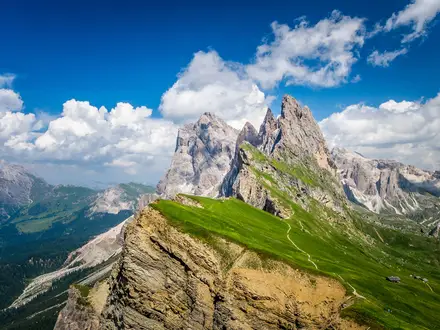
- 29 four-thousanders: The viewpoint takes in 29 peaks above 4,000 m, including Dufourspitze on the Monte Rosa massif, Liskamm, the Dom and the Weisshorn.
- Gornergrat Bahn and Kulmhotel: The rack railway gives easy access to the 3,000 m-plus ridge. At the summit, the Kulmhotel’s two observatory domes are used for the Stellarium Gornergrat.
- Riffelsee lake: This small alpine tarn below Rotenboden is the route’s main photo stop, especially when the Matterhorn reflection is visible.
- Brother Klaus Chapel: The small Bruder-Klaus chapel at Riffelberg is shaped to echo the outline of the nearby Weisshorn.
Challenges to expect
The distance is short, but this is still a high-alpine walk. Expect thin air around 3,000 m, no shade, strong sun exposure and fast-changing mountain weather. The path is well signposted but rocky, stony and uneven in places, so sturdy footwear helps. Snow can linger outside the summer walking season; July to September is the most reliable window.
HikeList Score
Gornergrat Ridge Trail scored 76/100 on HikeList's trail-quality metrics.
See score breakdownHide breakdown
- Ideal length 55
- Balanced challenge 94
- Scenery & wildness 98
- Varied terrain 52
- Accommodation 57
- Food & support 74
- Path quality 98
- Season flexibility 76
Computed from length, challenge, scenery & wildness, terrain variety, accommodation, food & support, path quality and season flexibility.
 Switzerland
Show more data Show less
- Mountainous
- Rocky
- Dirt
- Hotels
- Family Friendly
- Restrooms
- Water Sources
Photos from hikers
Taken on the trail by people who've reviewed Gornergrat Ridge Trail.
Reviews
How would you rate Gornergrat Ridge Trail?
Tap a star to start your review — you could be the first.