Dartmoor Way
How would you rate Dartmoor Way?
Tap a star to share your experience and help other hikers.
Dartmoor Way: Complete Hiking Guide
HikeList Score
Dartmoor Way scored 92/100 on HikeList's trail-quality metrics.
See score breakdownHide breakdown
- Ideal length 97
- Balanced challenge 100
- Scenery & wildness 85
- Varied terrain 89
- Accommodation 100
- Food & support 88
- Path quality 84
- Season flexibility 89
Computed from length, challenge, scenery & wildness, terrain variety, accommodation, food & support, path quality and season flexibility.
The Dartmoor Way is a 174 km waymarked loop around the edge of Dartmoor National Park in Devon, England. Most walkers take 7-10 days, following the official 10-stage anticlockwise circuit from Ivybridge through moorland-edge towns, wooded river valleys, farmland and quiet lanes. It is a moderate long-distance walk: not alpine, but long, often wet underfoot, and with short steep climbs plus some open-moor navigation. Compare it with other UK multi-day routes such as Beacons Way, Anglesey Coastal Path and Arran Coastal Way.
Route Overview
The recommended start and finish is Ivybridge, which has mainline rail and bus access, though walkers can join the loop anywhere. Official route descriptions run anticlockwise, linking Shipley Bridge, Buckfastleigh, Ashburton, Bovey Tracey, Moretonhampstead, Chagford, Okehampton, Lydford, Tavistock and Shaugh Bridge before returning to Ivybridge. The main walking route is a full circuit of Dartmoor’s edge; an optional High Moor Link runs between Buckfast, Hexworthy and Tavistock, crossing the interior near Princetown. The Way is waymarked with Dartmoor Way discs, but open-moor sections and poor weather still require proper map-and-compass navigation.
How the Dartmoor Way developed
The Dartmoor Way began around 1999-2000 as a partnership between Dartmoor towns aiming to create cycling and walking routes for visitors. The early walking route was mainly a northern-moor circuit with map-based directions. From 2010, the steering group revived and extended the idea into a full circuit. As a DNPA and Ramblers project, managed by Dartmoor Way CIC, the 108-mile walking route was waymarked from scratch in 2019 and relaunched around 2020.
Notable highlights
High Willhays (621 m): Dartmoor’s highest point and the highest ground in England south of the Peak District. The Way passes beneath or near this granite-tor summit on the open northern moor.
Castle Drogo: A National Trust property above the Teign Gorge near Drewsteignton. Designed by Edwin Lutyens for Julius Drewe, it is known as the last castle built in England.
Teign Gorge: A deep wooded gorge cut by the River Teign. The Hunter’s Path and Fisherman’s Path give some of the route’s best river-and-woodland walking.
Lydford Gorge: The deepest river gorge in South West England (National Trust), on the western side of Dartmoor, known for the 30 m White Lady Waterfall and the swirling Devil’s Cauldron pothole.
Buckfast Abbey: A working Benedictine monastery near Buckfastleigh, rebuilt on medieval foundations and closely associated with Buckfast Tonic Wine.
Haytor Granite Tramway: An early horse-drawn tramway with granite rails, built to move stone from Haytor Down. Haytor Rocks rises above the eastern moor nearby.
Challenges to expect
Expect wet ground, boggy sections after rain, stony moorland paths, woodland tracks, field paths and a noticeable amount of quiet lane walking. Dartmoor weather changes quickly: mist, wind and heavy rain are common, especially on open ground. Although the route is waymarked, some open-moor sections are unwaymarked and need map-and-compass competence. Resupply is helped by regular towns and villages, but daily distances are still committing.
HikeList Score
Dartmoor Way scored 92/100 on HikeList's trail-quality metrics.
See score breakdownHide breakdown
- Ideal length 97
- Balanced challenge 100
- Scenery & wildness 85
- Varied terrain 89
- Accommodation 100
- Food & support 88
- Path quality 84
- Season flexibility 89
Computed from length, challenge, scenery & wildness, terrain variety, accommodation, food & support, path quality and season flexibility.
 United Kingdom
 England
Show more data Show less
- Mountainous
- Forest
- Rural
- Dirt
- Rocky
- Gravel
- Paved
- Hotels
- Guesthouses
- Hostels
- Campsites
- Wild Camping Spots
- Family Friendly
- Pet Friendly
- Restrooms
- Water Sources
- Campsites
- Picnic Areas
Download Our Full Guide to Dartmoor Way FREE!
Get our comprehensive guide to this hike for free. Save it for later reading or print out at home.
In these collections
Photos from hikers
Taken on the trail by people who've reviewed Dartmoor Way.
Dartmoor Way: The Complete Guide
 i
Image by veneratio
i
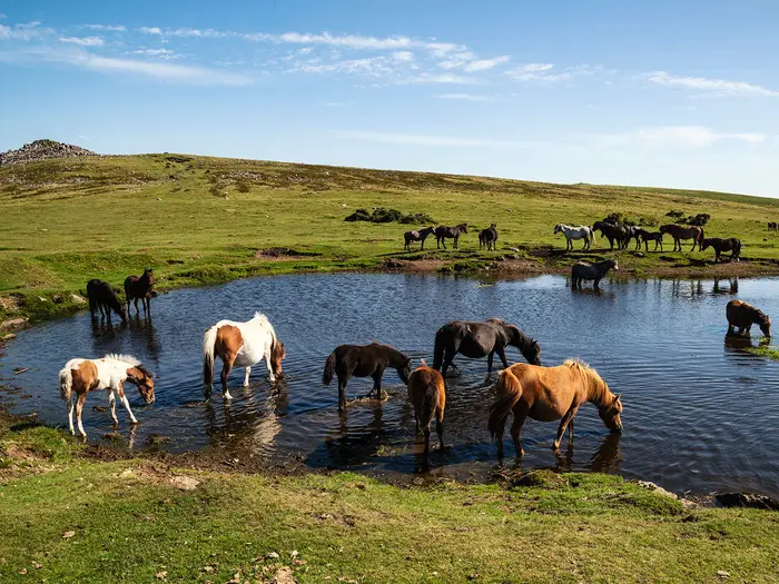
Image by veneratio The Dartmoor Way is a 108-mile circular walk around the edge of Dartmoor National Park, starting and finishing at Ivybridge. It suits walkers who want a sustained Devon long-distance route with regular towns, pubs and accommodation, rather than a remote high-moor traverse.
Its character is moor-edge walking: wooded river valleys, stone-walled fields, bridleways, old railway lines, quiet lanes and stretches of open ground beneath the granite uplands. The route links places such as Buckfastleigh, Ashburton, Bovey Tracey, Moretonhampstead, Chagford, Okehampton, Lydford and Tavistock, keeping resupply and overnight stops relatively practical.
The main waymarked route does not summit Dartmoor’s highest tops, but the moor is never far away. Highlights include the Teign Gorge, Castle Drogo, Buckfast Abbey, Haytor’s Granite Tramway, Lydford Gorge, Okehampton Castle and the northern moor below High Willhays.
This is a moderate walk, not a soft one. Daily stages are long enough to matter, the total ascent is substantial, and Dartmoor weather can bring mist, wind, rain, boggy ground and open-moor navigation where waymarks are absent.
This guide covers stages, itineraries, accommodation, food and water, transport, terrain, navigation, seasons, luggage transfer and common planning mistakes.
Stage-by-Stage Guide
The stages below follow the official anti-clockwise circuit from Ivybridge. Distances are approximate, and the route should still be planned with the official GPX files and a proper Dartmoor map, especially where the Way crosses open moorland or poorly waymarked ground.
Stage 1: Ivybridge to Shipley Bridge — 16 km
This opening stage leaves Ivybridge from the historic Ivy Bridge on Harford Road and quickly mixes town-edge paths with lanes, farmland and open moorland. The day has around 620 m of ascent, so it is a stronger start than the distance alone suggests.
The route uses sections of the old Redlake Tramway trackbed, field paths with stone stiles and kissing gates, and open ground around Western Beacon. Landmarks include Stowford Mill, the Cantrell clay works chimney, Bittaford Viaduct, Pennaton clay settling tanks and Corringdon Ball, the only chambered long barrow on Dartmoor.
Western Beacon gives wide views south over the South Hams and towards the English Channel, with Ugborough Beacon and Brent Hill also prominent. The Horse and Groom at Bittaford is the main food-and-drink option near the route; after that, services are limited.
Shipley Bridge is a car park and moorland access point, not a village stop. There are toilets, but no food or accommodation at the stage end, so accommodation walkers normally arrange a pickup or taxi, use South Brent off-route, or combine this with the next stage towards Buckfastleigh or Ashburton.
Navigation is mostly straightforward on waymarked paths, but the open moorland near Western Beacon needs care in poor visibility. Watch for golfers when crossing Wrangaton Golf Course, and expect wet ground and awkward stream crossings after heavy rain.
Stage 2: Shipley Bridge to Ashburton — 16.8 km
From Shipley Bridge the route begins on the tarmac access road towards Avon Dam before moving onto bridleways, moorland tracks and field paths. With around 448 m of ascent, it is a moderate day, but underfoot conditions can slow progress after wet weather.
The Avon Dam and Reservoir are the early focus, followed by higher moorland around Hunters Stone and sections associated with the Abbot’s Way. The approach towards Buckfastleigh brings the route into more settled country, with Buckfast Abbey a worthwhile short detour near Buckfast.
Buckfastleigh is the key resupply point, with shops, pubs and cafés. Buckfast Abbey also has visitor facilities when open, and Ashburton is a well-served market town with several pubs, cafés and accommodation options.
Ashburton has buses but no railway. Timetables should be checked before travelling, especially if using public transport to split the route here.
Navigation is generally good, but the overgrown Ashburton Footpath 13 section can be unpleasant in wet conditions, and there are stile-heavy field sections between Button and Billberryhill. A deeply rutted farm lane near Gages and Summerhill can also be awkward when muddy.
Stage 3: Ashburton to Bovey Tracey — 19.6 km
This is one of the tougher days on the circuit, with around 702 m of ascent — the largest ascent total of any official stage. The walking combines field paths, bridleways, lanes, open moorland, woodland and a notable section on or near the Haytor Granite Tramway.
Haytor Rocks are the headline landmark, reached after the main climb towards the eastern moor. The granite rails of the Haytor Granite Tramway remain visible in places, making this one of the route’s strongest industrial-history sections. The route also passes near Haytor Iron Mine, Pinchaford Ball Tor, Yarner Wood and the Parke Estate.
The Rock Inn at Haytor Vale is the main mid-stage food stop on or very close to the route. Bovey Tracey is a useful overnight and resupply town, with cafés, pubs, shops and a reasonable choice of B&Bs, inns and guesthouses.
Bovey Tracey has bus links to Newton Abbot and Exeter. This should be checked before travelling if ending or starting a section here.
Navigation is mostly waymarked, but mist around Haytor can make the open moorland feel much more serious. The section beside the B3387 is straightforward but affected by road noise, and the wooden plank bridge over Bovey Pottery Leat can be slippery when wet.
Stage 4: Bovey Tracey to Moretonhampstead — 16.9 km
This stage starts gently on old railway alignment through the Parke Estate and the Wray Valley Trail before moving into woodland, ancient lanes, bridleways and field crossings. The day has around 598 m of ascent, with the steepest work through Houndtor Wood from Becka Brook towards Water.
Key features include Mill Marsh Park, Hisley Bridge, Becka Brook packhorse bridge, North Bovey, Water hamlet and views towards Hunters Tor. Trendlebere Down, Lustleigh Cleave, Haytor Rocks and Meldon Hill provide much of the day’s visual interest.
The Kestor Inn at Water is a useful lunch stop with a slight detour. Moretonhampstead is a proper Dartmoor market town and one of the better overnight bases, with pubs, cafés, B&Bs, pubs with rooms and backpacker-style accommodation.
Moretonhampstead has limited bus services, so public-transport plans should be checked before travelling. It is a practical section stop, but not a major transport hub.
The route is mostly well signed, though the final approach to Moretonhampstead uses the B3212 where there is no footpath. Walk facing traffic and take particular care in poor visibility or at busy times. Cattle with calves may be encountered in fields near the end of the stage.
Stage 5: Moretonhampstead to Chagford — 12.7 km
This is the shortest official stage, but it should not be dismissed as an easy stroll. It uses field footpaths, woodland, moorland tracks, bridleways and riverside paths through some of the finest scenery on the route, with around 463 m of ascent.
The stage shares ground with the Two Moors Way and passes Butterdon Hill standing stone, with an optional detour to Cranbrook Castle. The main highlight is the River Teign and the Teign Gorge, where the Hunter’s Path and Fisherman’s Path give superb woodland and gorge walking.
Fingle Bridge is the obvious mid-stage stop, with the Fingle Bridge Inn directly on the route. Drewsteignton is worth a detour for village services and access to Castle Drogo, the National Trust castle above the gorge; admission charges and seasonal opening apply, so this should be checked before travelling.
Chagford is one of the best-served overnight stops on the circuit, with multiple cafés, pubs, inns, B&Bs and holiday lets. Limited bus services operate in this part of Dartmoor, and current timetables should be checked before relying on them.
Navigation is generally good, with fingerposts and shared Two Moors Way sections, but the climb through Drewston Wood from Fingle Bridge is steep and can be slippery after rain. The Hunter’s Path is not technical, but exposed sections above the gorge require good footwear and attention in wet conditions.
Stage 6: Chagford to Okehampton — 19.4 km
This is a long and varied northern-moor stage, with around 639 m of ascent and a mix of woodland, lanes, village paths, river-valley walking and open moorland. It is one of the days where weather and navigation matter most.
The route passes through or near Throwleigh, South Zeal, Sticklepath, Belstone and Belstone Cleave before descending towards the East Okement River and Okehampton. Notable landmarks include the Ramsley Hill copper mining chimney, Finch Foundry at Sticklepath, Belstone village, Fatherford Viaduct and Okehampton Town Mill.
Food and drink options include South Zeal, Sticklepath when Finch Foundry facilities are open, Belstone and Okehampton. National Trust opening times and admission at Finch Foundry should be checked before planning a visit.
Okehampton is the largest town on the route and a strong resupply and overnight stop, with hotels, B&Bs, a YHA hostel, supermarkets and outdoor shops. It has bus services to Exeter and rail services on the Dartmoor Line; current timetables should be checked before travelling.
The open moorland around Belstone Common is not always waymarked, and map-and-compass skills are needed in mist. Belstone Cleave is a demanding climb, stepping stones at War Cleave Woods weir need care, and High Willhays is nearby and visible from the northern moor but is not climbed by the main Dartmoor Way.
Stage 7: Okehampton to Lydford — 15.5 km
This is the easiest official stage in terms of ascent, with around 312 m of climbing, and it makes a useful recovery day after the harder northern-moor walking. Much of the stage follows the Granite Way on the former London & South Western Railway alignment.
The Meldon Viaduct is the main landmark, standing high above the valley with views towards Meldon Reservoir, Yes Tor and the High Willhays massif. The route continues through or near Sourton, Lake and Bridestowe before reaching Lydford.
Okehampton should be used for a full resupply before leaving. There are public toilets at Meldon Reservoir and pub or refreshment options at settlements such as Sourton, Lake and Bridestowe, with further services in Lydford.
Lydford is a small village with accommodation including the Castle Inn and B&Bs. It is road-accessible, but onward public transport options should be planned in advance rather than assumed.
Navigation is among the most straightforward on the route because the railway alignment is clear and easy to follow. The Granite Way is shared with cyclists, Meldon Viaduct is exposed in high winds, and the reservoir is a working water supply where restrictions must be respected.
Stage 8: Lydford to Tavistock — 20.4 km
This is the longest official stage, so an early start is sensible. It has around 486 m of ascent and combines road walking out of Lydford, open moorland around Black Down, bridleways, woodland, farm roads and moorland-edge paths towards Tavistock.
Lydford Castle and St Petroc’s Church are close to the start. Lydford Gorge is a major National Trust attraction, with the White Lady Waterfall and Devil’s Cauldron, but it is best treated as a separate visit before setting off or the previous evening because it can take a substantial part of the day.
The route passes Mary Tavy and Peter Tavy, with the Peter Tavy Inn making the key mid-stage food stop. Later landmarks include Great Coombe Tor, Cox Tor, Whitchurch Down, Pixies Cross and the long approach into Tavistock.
Tavistock is one of the best service towns on the route, with supermarkets, shops, cafés, pubs and a wide range of accommodation. It has bus services to Plymouth but no railway.
Navigation is generally good through the villages, but the moorland crossing via Mary Tavy Footpath 32 is not always well waymarked and needs map work. The descent from Great Coombe Tor is steep, and the distance from Peter Tavy to Tavistock is still significant, so do not treat the pub as the end of the day.
Stage 9: Tavistock to Shaugh Bridge — 18.6 km
This stage leaves Tavistock on urban paths and the Tavistock Canal before moving onto bridleways, riverside single track, disused railway alignment, field crossings and leat-side paths. It is a varied day with around 427 m of ascent and some of the best easy valley walking of the southern half.
Key features include St John’s Well, Tavistock Canal, Gem Bridge, the Walkham Valley, Magpie Viaduct and Plymouth Leat. The route also passes through a strong mining and transport landscape before finishing near the Shaugh China Clay Works ruins.
There are very limited services between Tavistock and Shaugh Bridge. The Rock Inn at Yelverton is the main food option, with a slight detour, so carry food and water from Tavistock.
Shaugh Bridge is another genuine service gap. The stage ends at the old clay works car park area, with no accommodation at the endpoint and very limited food nearby; most walkers arrange a taxi, pickup or accommodation off-route in advance.
Navigation is generally good, especially where the route follows Drake’s Trail and Plymouth Leat. The Tavy, Walkham and Meavy crossings are bridged, but river levels can be high after heavy rain, and riverside paths may be muddy or slippery.
Stage 10: Shaugh Bridge to Ivybridge — 19.2 km
The final stage returns to Ivybridge through woodland, open moorland, lanes, field crossings and the china-clay heritage landscape of the southern moor. It has around 514 m of ascent, with several short climbs and descents rather than one sustained mountain section.
The stage starts near Shaugh Bridge, where the Plym and Meavy rivers meet, and passes the Dewerstone, Cadover Bridge and Trowlesworthy Tors. The prehistoric double stone row at Trowlesworthy is one of the best archaeological features on the final day.
There are wide views across the Meavy, Plym, Yealm and Erme catchments, with Plymouth Sound visible in clear weather. China clay workings are a constant reminder of the industrial landscape on this side of Dartmoor.
Food and water options are limited. The community-run Cornwood Inn is a useful final-day stop with a minor detour, but there are no other reliable facilities directly on the route between Shaugh Bridge and Ivybridge.
Ivybridge has accommodation, bus links and a mainline railway station, making it the most practical place to finish the circuit. Trains and local transport should still be checked before travelling.
Navigation is helped by clear Dartmoor Way markers and well-defined woodland and moorland tracks, but care is still needed at river crossings and on wet ground near the water. The descents through North Wood can be steep, and the exposed moorland edges are vulnerable to wind, rain and poor visibility.
Recommended Itinerary
Standard 10-day itinerary
The most straightforward schedule is the official 10-stage, anti-clockwise circuit from Ivybridge. Daily distances stay between 12.7 km and 20.4 km, which keeps the walk manageable while still requiring steady full-day pacing.
| Day | From | To | Approx. distance | Why this stage makes sense | Services/accommodation notes |
|---|---|---|---|---|---|
| 1 | Ivybridge | Shipley Bridge | 16 km / 10 miles | A moderate first day out of Ivybridge, giving time for travel to the start if arriving the day before. | Shipley Bridge is remote and has very limited services. It works best for campers, self-catering arrangements or walkers with a pre-arranged transfer; it is not the easiest inn-to-inn overnight. |
| 2 | Shipley Bridge | Ashburton | 16.8 km / 10.5 miles | A practical second stage into a proper market town, with Buckfastleigh / Buckfast on this southern side of the route. | Ashburton has pubs, B&Bs, shops and a Co-op, making it a far better serviced overnight than Shipley Bridge. |
| 3 | Ashburton | Bovey Tracey | 19.6 km / 12.3 miles | One of the longer standard days, but it ends in a well-served town and keeps the eastern side of the circuit neatly paced. | Bovey Tracey has a good spread of accommodation, cafés and pubs. Book ahead in busy periods. |
| 4 | Bovey Tracey | Moretonhampstead | 16.9 km / 10.6 miles | A balanced day between two useful moor-edge towns, with enough distance to make progress without forcing a long finish. | Moretonhampstead is small but serviceable, with a Co-op, pubs and B&Bs. |
| 5 | Moretonhampstead | Chagford | 12.7 km / 8 miles | The shortest official stage, well placed as a lighter day after four steady days. It is also useful for laundry, resupply and a slower afternoon. | Chagford is a good overnight stop, with pubs, B&Bs and independent shops. Pub-with-rooms options include The Chagford Inn. |
| 6 | Chagford | Okehampton | 19.4 km / 12.2 miles | A more serious day onto the northern side of Dartmoor, where open-moor weather and navigation matter more. | Okehampton is the best resupply stop on the northern arc, with a Co-op, pubs, hotels, a Youth Hostel and rail connections towards Exeter. |
| 7 | Okehampton | Lydford | 15.5 km / 9.7 miles | A shorter but wilder-feeling stage after Okehampton, with remote terrain and more need for confident navigation. | Lydford is small and has limited shopping. Stock up in Okehampton; accommodation includes pub-with-rooms options such as The Castle Inn and The Dartmoor Inn. |
| 8 | Lydford | Tavistock | 20.4 km / 12.8 miles | The longest official stage, but it finishes in one of the best-served towns on the route. Start promptly and avoid treating it as an easy day. | Tavistock has extensive services, supermarkets, pubs, hotels and bus links, making it an excellent overnight and resupply point. |
| 9 | Tavistock | Shaugh Bridge | 18.6 km / 11.6 miles | A solid penultimate day into the Plym valley area, setting up the final return to Ivybridge. | Shaugh Bridge is awkward for overnight planning, with very limited services. Campers may find it workable; others should arrange accommodation nearby or a taxi transfer to Ivybridge or Plymouth. |
| 10 | Shaugh Bridge | Ivybridge | 19.2 km / 12 miles | A final full-length day back to the railway town where the circuit began. | Ivybridge has town facilities, accommodation and a mainline railway station for onward travel. |
Slower 11–12 day itinerary
A slower plan suits walkers who want more time for places such as Castle Drogo, the Teign Gorge, Lydford Gorge or the Haytor area, or anyone who prefers not to walk repeated 19–20 km days. It is also the better choice if carrying full camping kit.
The most useful stages to split are:
| Section to split | Why split it | Practical approach |
|---|---|---|
| Ashburton to Bovey Tracey | At 19.6 km / 12.3 miles, this is one of the longer early days. | Consider an overnight around Haytor or Widecombe-in-the-Moor, where suitable accommodation must be checked before booking. |
| Chagford to Okehampton | At 19.4 km / 12.2 miles, this stage crosses more serious northern moorland terrain. | A split near Drewsteignton / Castle Drogo gives more time for the Teign Gorge area. Accommodation and exact mileage should be checked against official mapping before booking. |
| Lydford to Tavistock | At 20.4 km / 12.8 miles, this is the longest official day. | Splitting can make sense if accommodation or transfer logistics allow; this should be checked before travelling. |
The slower option is often the most enjoyable inn-to-inn version if sightseeing matters as much as completion. Self-guided operators also offer longer versions with accommodation and luggage transfer, commonly from Ivybridge.
Faster 7–8 day itinerary
A faster schedule is realistic only for fit walkers who are happy with longer days, less margin for bad weather and fewer relaxed afternoons in the towns. It is not the best plan for a first long-distance walk on Dartmoor, particularly because some open-moor sections are unwaymarked and poor visibility can slow progress sharply.
Common ways to shorten the itinerary include combining the shorter middle stages and using transfers where overnight places are awkward:
| Faster option | What it changes | Who it suits |
|---|---|---|
| Combine Bovey Tracey → Moretonhampstead → Chagford | This joins Stage 4 and Stage 5 into a 29.6 km day using the official stage distances. | Strong walkers who want to use Chagford as the next major overnight and are comfortable with a long day. |
| Push through or transfer around Shipley Bridge | Shipley Bridge is a difficult overnight for non-campers, so some walkers continue beyond it or arrange a transfer. | Inn-to-inn walkers who do not want a remote first-night stop. Exact mileage and accommodation should be checked against official mapping before booking. |
| Avoid an overnight at Shaugh Bridge | Shaugh Bridge has very limited services, so a taxi transfer or a longer final push can simplify logistics. | Walkers prioritising accommodation certainty over strict stage-end purity. This should be arranged before travelling. |
Seven-day self-guided versions are available from operators such as Contours, usually with luggage transfer and a demanding rating. Current package prices and inclusions should be confirmed before booking.
Planning the Route
How many days to allow
The official Dartmoor Way walking route is divided into 10 stages, and that is the most straightforward schedule for independent walkers. It keeps most days in a manageable range and uses the natural ring of moor-edge towns and villages for overnight stops.
Most walkers should allow 7–10 days. A 10-day itinerary is the most comfortable way to follow the official stages without repeatedly combining long days; a 7-day itinerary is realistic for fitter walkers but means longer daily mileage and less margin for bad weather, navigation delays or accommodation constraints.
Self-guided operators commonly offer 7, 9 or 11 walking-day versions. Fit backpackers can compress the route into 5–6 days, but that suits experienced walkers who are happy with long days on mixed surfaces, including lanes, field paths and open moor. Beginners or walkers wanting shorter days may need 12–14 days, especially if using public transport to reach accommodation off-route.
| Itinerary pace | Best suited to | Planning implications |
|---|---|---|
| 5–6 days | Strong, experienced backpackers | Long days; little slack for poor visibility or wet ground |
| 7 days | Fit walkers travelling light | Several official stages need combining; accommodation must be planned carefully |
| 9–10 days | Most independent walkers | Best balance of distance, logistics and weather allowance |
| 11–14 days | Gentler pace, beginners, section-style walkers | More overnights to book; may require short transfers or off-route accommodation |
Choosing where to start
Ivybridge is the conventional and recommended start because it has a mainline railway station and good bus links. It also makes sense for baggage-transfer holidays, which normally start and finish there.
Because the Dartmoor Way is a loop, there is no obligation to start at Ivybridge. Okehampton, Tavistock and Bovey Tracey are all practical alternatives for walkers joining the route from other parts of Devon or splitting it into sections.
The key is to choose a start point that works with both transport and accommodation. A circular route looks simple on paper, but some stage ends are much harder to reach without a car or pre-booked taxi.
How fixed are the stages?
The official stages are useful because they normally finish in places with services such as accommodation, a shop or a pub. This makes the Dartmoor Way easier to plan than a remote upland route where camps or bothies dictate the schedule.
The stages are still not completely flexible. Accommodation is limited in several smaller places, and single-night stays may not always be available, particularly at busy times or outside the main walking season.
The most awkward overnight points are Shipley Bridge and Shaugh Bridge. Both are remote valley locations with very limited accommodation and little or no convenient public transport, so they need special attention before the itinerary is finalised.
If beds are not available at those points, options include walking on to a larger settlement, using nearby campsites or self-catering where available, or arranging a taxi transfer. Do not plan to arrive there and solve the problem on the day.
Accommodation strategy
Book accommodation before starting the route. The Dartmoor Way has a good ring of towns and villages, but it is not a trail where every overnight stop has abundant spare beds.
Advance booking matters most during bank holidays, school holidays and summer weekends. Some B&Bs and inns may also close between late autumn and Easter, and some places do not accept single-night bookings.
Independent walkers should book every night before committing to travel dates. Self-guided companies such as Contours and Encounter Walking Holidays arrange accommodation and luggage transfer, which removes much of the logistical pressure but reduces flexibility once dates are set.
Food, water and resupply
The town-to-town structure makes resupply relatively straightforward compared with a high-moor traverse. Most official stage ends have basic services, and larger places such as Ivybridge, Ashburton, Bovey Tracey, Moretonhampstead, Chagford, Okehampton, Lydford and Tavistock are the natural points for food planning.
Do not assume that shops, cafés or pubs will be open when needed, especially on Sundays, bank holidays or late in the day. Carry enough food for the full walking day, plus a reserve snack layer for delays.
Water should be treated as a daily carry rather than something to improvise from moorland streams. The route includes villages and pubs, but open sections, quiet lanes and remote valleys can leave long gaps between reliable refill points.
Navigation planning
Navigation is a genuine planning issue on this route. The Dartmoor Way is waymarked with small circular purple discs, but several open-moor sections have no waymarking and require map-and-compass competence.
The official website provides GPX files for the full route, individual stages, the High Moor Link and six poor-weather alternatives. Download these before travelling and check how they display on the device or app being used.
The recommended map is OS Explorer OL28 Dartmoor at 1:25,000. A small section on the western side of the moor falls outside OL28’s coverage, so map coverage should be checked before buying, printing or relying on a single sheet.
In mist or fog, Dartmoor can be disorientating even on modest ground. The main route does not climb Dartmoor’s highest tops, but open moorland, boggy ground and indistinct paths still make visibility a serious factor.
Using the poor-weather alternatives
The official poor-weather alternatives are there for a reason. They detour around the more exposed or navigation-sensitive open sections and should be studied before the walk, not discovered during a storm.
Build enough flexibility into the itinerary to use them without feeling that the whole schedule will collapse. A faster 7-day plan leaves less room for sensible weather decisions than a 9- or 10-day plan.
The High Moor Link
The High Moor Link is an optional interior crossing of about 37 km / 23 miles between Buckfastleigh/Buckfast and Tavistock, via the higher moor near Princetown and Hexworthy. It can turn the Dartmoor Way into a figure-of-eight route or split it into shorter northern and southern loops.
This is useful for walkers with less time, or for anyone wanting to complete the route over two separate trips. It also gives a more direct high-moor experience than the main outer circuit.
It is not a bad-weather shortcut. The High Moor Link crosses higher, more exposed ground, has no poor-weather alternative routes, and should not be walked in poor visibility unless the walker is fully confident with map and compass.
Section hiking
The Dartmoor Way is well suited to section hiking because it is circular and many stages start or finish in accessible towns. Weekend walkers can complete individual stages or link two together, then return by public transport or taxi.
The easiest access points for section walkers are Ivybridge, Okehampton, Tavistock, Ashburton/Buckfastleigh and Bovey Tracey. These have stronger transport links than the smaller valley endpoints.
Public transport is much weaker at Shipley Bridge and Shaugh Bridge. These sections need more careful planning, especially on Sundays or if finishing late.
Transport planning
Ivybridge has mainline rail access and is the simplest public-transport start. Okehampton has rail access from Exeter on the Dartmoor Line, but timetables should be checked before travelling.
Newton Abbot is a useful mainline railhead for onward buses towards places such as Bovey Tracey, Ashburton and Buckfastleigh. Tavistock is generally reached by bus, including services from Plymouth.
Useful bus links include:
| Service | Useful for | Notes |
|---|---|---|
| 178 | Bovey Tracey – Moretonhampstead – Okehampton | Monday–Saturday |
| 118 | Okehampton – Lydford – Tavistock | Monday–Saturday |
| X38 | Ashburton / Buckfastleigh – Ivybridge | Runs on Sundays too |
| 1 | Tavistock – Yelverton | Runs on Sundays too |
| 98 | Princetown – Tavistock | Monday–Saturday; useful for High Moor Link access |
Bus timetables and operating days change, and Sunday services are limited around much of Dartmoor. This should be checked before travelling, particularly if planning to start, finish or bail out on a Sunday.
For remote endpoints, book taxis in advance rather than assuming one can be called at short notice. Mobile signal and taxi availability should not be relied on in quiet valleys.
Permits, camping and access
No permit is required to walk the main Dartmoor Way. Standard public rights of way and access land rules apply.
Wild camping in Dartmoor’s designated open-access camping areas does not require a permit, but it is only allowed in specific areas. Consult the Dartmoor National Park camping map before planning to camp, and do not assume that every moorland section is available for overnight camping.
MOD firing ranges affect open country on the northern moor near Okehampton. The main waymarked route does not enter live firing areas, but the firing programme should be checked if planning any cross-country detours.
Main planning priorities
Before fixing dates, decide whether the walk will follow the 10-stage official structure, a faster combined-stage plan, or a split route using the High Moor Link. Accommodation availability may decide the final itinerary more than fitness does.
Download the official GPX files, poor-weather alternatives and any High Moor Link files before setting off. Carry a paper map and compass, and know how to use them on open ground.
Check public transport carefully, especially for Sundays and for the remote endpoints at Shipley Bridge and Shaugh Bridge. Where buses do not line up with the itinerary, arrange taxis before starting the walk.
Towns, Villages and Overnight Stops
The Dartmoor Way is much easier to organise than a remote upland traverse because it repeatedly drops into moor-edge towns. The main planning traps are the two non-village stage points: Shipley Bridge and Shaugh Bridge. Neither has services at the bridge itself, so accommodation must be planned deliberately.
| Place | Overnight practicality | Food and resupply | Transport usefulness |
|---|---|---|---|
| Ivybridge | Good choice | Full town resupply | Mainline rail; bus X38 |
| Shipley Bridge | Very limited / plan carefully | None at the bridge | No practical service hub |
| Buckfastleigh / Buckfast | Adequate to good | Shops, pubs, cafes, Abbey facilities | Bus X38 |
| Ashburton | Good choice | Strong food options; Co-op | Bus X38; rail via Newton Abbot |
| Bovey Tracey | Good choice | Independent shops, cafes, pubs | Buses towards Newton Abbot; route 178 |
| Moretonhampstead | Adequate | Small supermarket, butcher/deli, pubs, cafes | Buses to Exeter/Newton Abbot |
| Chagford | Good choice | Spar, butcher, baker, pubs, cafes | Limited bus; taxi often practical |
| Okehampton | Good choice | Full resupply; major supermarkets | Dartmoor Line rail; buses 118/178 |
| Lydford | Limited | No general shop; pub food | Bus 118, timetable-dependent |
| Tavistock | Very good choice | Best market/resupply on western side | Buses to Plymouth and Okehampton |
| Shaugh Bridge | Very limited / plan carefully | None at the bridge | No practical service hub |
Ivybridge
Ivybridge is the recommended start and finish for the loop and the easiest place to arrange travel, supplies and a first or final night. The railway station is on the trail itself, which makes it unusually convenient for a long-distance walk start.
Accommodation is reasonable for a town of this size, with B&Bs, self-catering cottages and inns. It is a sensible place to stay the night before walking, especially if arriving by train.
The town centre has a Co-op, independent shops around Fore Street and Glanvilles Mill, and enough choice for a full first resupply. Pub options include The Sportsman's Inn, Trehill Arms, Exchange, Old Smithy, Duke of Cornwall and Imperial.
Ivybridge has mainline Great Western Railway services on the Plymouth–Exeter–London Paddington line; current GWR timetables should be checked before booking. Bus X38 also links Ivybridge with South Brent, Buckfastleigh and Ashburton.
Shipley Bridge
Shipley Bridge is not a village. It is a remote stream crossing and car park above the Avon valley, used as the end of Stage 1 and the start of Stage 2 on the 10-stage itinerary.
There is no pub, no shop and no accommodation at the bridge itself. Treat it as a route point, not a service stop.
Walkers using the official stage split need a plan here: either continue beyond Shipley Bridge towards Buckfastleigh, arrange accommodation in the wider farm/B&B network, or use a camping plan that is legal and appropriate for Dartmoor. This should be checked before travelling.
The lack of services makes Shipley Bridge one of the key booking hazards on the route. Do not assume there will be food, shelter, taxis or last-minute rooms available nearby.
Buckfastleigh / Buckfast
Buckfastleigh and nearby Buckfast sit on the southern edge of Dartmoor and are practical places to break the early part of the route. They are especially useful if Shipley Bridge does not suit as an overnight stop.
Buckfastleigh has a Co-op on or close to the route, independent high-street shops, cafes and local pubs. Food stops include No. 44 tea rooms, the Abbey Inn by the River Dart, and Buckfast Abbey's Grange Restaurant during opening hours.
Accommodation is better than the size of the town might suggest. Options include pub rooms, inns, hotels, farm B&Bs and Northgate House at Buckfast Abbey; availability should be checked early in busy periods.
Buckfast Abbey is about 1 km from Buckfastleigh town centre and is worth allowing 30–60 minutes if the day allows. Entry is free, with shops and restaurant facilities on site.
Bus X38 links Buckfastleigh with Ivybridge and Ashburton and also operates on Sundays, though current timetables should still be checked. The South Devon Railway runs heritage steam services between Buckfastleigh and Totnes in season, but it should be treated as a visitor attraction rather than core transport planning.
Ashburton
Ashburton is the Stage 2 finish and Stage 3 start, and one of the stronger overnight stops on the south-eastern side of Dartmoor. It is a compact historic town with enough accommodation, food and resupply options to make logistics straightforward.
There is a Co-op on the route and a good range of independent shops, including bakeries, delis, bookshops, antiques and galleries. For walkers, the practical benefit is simple: Ashburton is a reliable place to buy food for the next stage.
Accommodation includes B&Bs, guesthouses, boutique inns and nearby camping options such as River Dart Country Park and Summerhill Farm Campsite in the area. Book ahead in holiday periods, as the town is popular beyond the walking market.
Bus X38 links Ashburton with Ivybridge and Buckfastleigh. The nearest rail access is at Newton Abbot, about 10 km east by bus or taxi.
Stage 3 from Ashburton to Bovey Tracey is around 19.6 km, making this a good place to start with breakfast, packed food and a full water plan.
Bovey Tracey
Bovey Tracey is a good overnight stop on the eastern edge of Dartmoor and is commonly described as a gateway to the moor. It has enough services for walkers without feeling like a large town.
There is no large supermarket in the immediate town centre, but independent provision is good: delis, butchers, farm produce and general local shops cover most walking needs. Cafes, tearooms, artisan bakeries and pubs provide plenty of meal options; the Cromwell Arms is one named pub option.
Accommodation is varied, with hotels, B&Bs, self-catering cottages and camping options in the wider area. Parke Estate camping availability should be checked before relying on it.
The Devon Guild of Craftsmen, set in a riverside historic watermill, is a worthwhile stop if timings fit, and Parke Estate offers woodland and riverside walking close to town. Haytor is accessible from Bovey Tracey, but it should be treated as an additional outing rather than an automatic part of the main walking day.
Transport links run towards Newton Abbot, which has the nearest mainline railway station. Bus route 178 also runs towards Okehampton; current timetables should be checked before building a stage plan around it.
Moretonhampstead
Moretonhampstead is a small Dartmoor market town and a practical, compact overnight stop between Bovey Tracey and Chagford. It is not as large as Okehampton or Tavistock, but it has enough for most walkers.
Resupply is manageable, with a small supermarket on or near the route, a butcher/deli and a newsagent. The town also has four pubs and three cafes, giving better food options than many settlements of similar size.
Accommodation includes hotels, B&Bs, self-catering and the Sports and Community Centre campsite. The town is popular with walkers and cyclists, so booking ahead is sensible in good-weather periods and school holidays.
Bus services link Moretonhampstead with Exeter and Newton Abbot. Dartmoor bus routes can be limited or seasonal, so current services should be checked before relying on them.
The next stage to Chagford is around 12.7 km, the shortest official stage. Strong walkers sometimes combine this with the previous day, but Moretonhampstead is still a useful stop if keeping to a 10-day schedule.
Chagford
Chagford is one of the best overnight stops on the Dartmoor Way, with a strong mix of accommodation, food and resupply. It sits on the north-eastern side of the moor before the route turns towards Okehampton.
The town has a Spar convenience store, butcher, baker and a range of independent shops, so resupply is straightforward. Food and drink options are good, including The Three Crowns, The Globe Inn, The Chagford Inn, Folklore Kitchen and Social, and The Beehive Farm Shop and Cafe.
Accommodation is excellent for a small town. The Three Crowns, The Globe Inn and The Chagford Inn all provide rooms, with additional B&Bs and self-catering nearby; premium accommodation such as Gidleigh Park lies outside the town.
Chagford is also a good place to slow the schedule if the weather is poor. Nearby walking interest includes the River Teign, Teign Gorge, Scorhill stone circle and Castle Drogo, although detours need to be fitted carefully around the next walking day.
Public transport is more limited here than at Ivybridge, Okehampton or Tavistock. Without a car, a taxi to or from Okehampton or Moretonhampstead is often the realistic option; current bus schedules should be checked before travelling.
Okehampton
Okehampton is the main service and transport hub on the northern side of the route. It is also the only stage town with a railway station apart from Ivybridge, making it the most useful bail-out or join-in point on the loop.
Resupply is easy. The town has Lidl, Co-op and Tesco Express, plus independent shops in the Victorian Arcade and a broad choice of cafes, pubs and restaurants.
Accommodation is varied, including country inns, B&Bs, self-catering cottages and YHA Okehampton, which is a practical budget option for walkers. This is a good place to reset kit, dry out, buy food and adjust plans before the western arc of the route.
The Dartmoor Line provides daily rail services to Exeter, with an approximate 40-minute journey time. Buses include the 118 towards Tavistock via Mary Tavy and Lydford, and the 178 towards Bovey Tracey and Newton Abbot; current timetables should be checked, especially for Sundays.
Useful nearby points include Okehampton Castle above the West Okement, Meldon Viaduct on the Granite Way, and Belstone Cleave. The route accesses the station via Fatherford Lane south of the station.
Lydford
Lydford is a small historic village and a useful stopping point between Okehampton and Tavistock, but it is not a full service hub. It needs earlier booking than the larger towns.
There is no general shop in the village, so food for the next day should be bought in Okehampton or carried in. The main pub option is the Castle Inn, a 16th-century pub with en-suite rooms, food, local ales and Devon cider.
Accommodation is limited compared with the main towns. The Castle Inn is the primary in-village option, with some B&Bs and farm stays in the wider area; book well ahead rather than relying on same-day availability.
Lydford Gorge is the key reason to pause here if time allows. The National Trust gorge includes the White Lady Waterfall and Devil's Cauldron, but opening is seasonal and current hours should be checked; a visit can add 2–3 hours.
Bus 118 between Tavistock and Okehampton passes through Lydford, but it is timetable-dependent. This should be checked before travelling, especially if using Lydford as a join, exit or rest point.
Tavistock
Tavistock is the best-serviced stop on the western arc of the Dartmoor Way and one of the most useful places on the whole route for food, accommodation and onward transport. It is a sizeable market town with far more choice than the smaller moor villages.
For resupply, Tavistock is excellent. There is a large Co-op at the end of the main street, a wide range of independent shops and the long-running pannier market, which is the best market on the route for fresh food.
Food options are broad, from historic pubs and cafes to restaurants and modern gastropubs. There is also a Costa with charging sockets, useful if electronics need attention before the final stages.
Accommodation choice is strong: B&Bs, inns, self-catering, country hotels and central budget rooms at the Queen's Head Hotel. Tavistock is the safest western-side choice if flexibility, drying space or a rest night is needed.
There is no railway station in Tavistock itself. Regular buses connect with Plymouth, the nearest mainline rail hub, and bus 118 runs towards Okehampton via Lydford; current times should be checked before booking onward travel.
Shaugh Bridge
Shaugh Bridge is not a village. It is a National Trust car park and river confluence point where the Rivers Plym and Meavy meet, used as the Stage 9 finish and Stage 10 start on the official stage pattern.
There are no services at Shaugh Bridge itself. The National Trust car park is not an accommodation or overnight parking solution.
Nearby Shaugh Prior is about 1 km away and has limited options, including the White Thorn Inn and The Old Vicarage B&B. Opening hours, room availability and whether the pub currently offers accommodation should be checked before travelling.
This is the second major logistics gap on the route after Shipley Bridge. Walkers wanting to stop here need to book ahead; otherwise, it is often simpler to treat Shaugh Bridge as an intermediate point and continue with a different stage split.
The final stage from Shaugh Bridge to Ivybridge is around 19.2 km. Strong walkers with an early start may combine Tavistock to Shaugh Bridge and Shaugh Bridge to Ivybridge differently, but that creates a long day and should only be planned with fitness, daylight and weather in mind.
Transport notes for overnight planning
Direct rail access is available at Ivybridge and Okehampton only. Tavistock is a major bus hub but has no railway station, so rail connections usually run via Plymouth.
Sunday services are sparse on many Dartmoor bus routes. If a stage depends on bus 118, bus 178, X38 or a connection to Newton Abbot, Exeter or Plymouth, check the current timetable before committing to accommodation.
The multi-operator Devon Day Ticket can be useful for public-transport section walking; with the £3 single-fare cap also in force on many Devon services, confirm the current ticket prices and which option works out cheapest before travelling.
Getting to the Start
Ivybridge is the recommended start and finish for the Dartmoor Way, and it is one of the easiest Dartmoor trailheads to reach without a car. Because the route is a loop, the same transport arrangements normally work for both arrival and departure.
By train
Ivybridge station (IVY) is on the Great Western Main Line between Plymouth and Exeter. Great Western Railway and CrossCountry services stop here, giving direct or simple rail access from much of southern and western England.
| From | Typical journey to Ivybridge | Notes |
|---|---|---|
| London Paddington | around 3 hours 20 minutes on average; fastest about 2 hours 58 minutes | Direct GWR trains run to Ivybridge; advance fares are usually cheaper. |
| Bristol Temple Meads | around 2 hours 26 minutes on average; fastest about 2 hours 8 minutes | CrossCountry is the main operator on this approach. |
| Exeter St Davids | about 46–53 minutes | Useful if connecting from Exeter Airport or other Devon services. |
| Plymouth | about 13 minutes | The nearest major rail hub and a practical overnight base. |
The station has step-free access to both platforms via ramps, a sheltered waiting area, customer help points and staff on site. It does not have toilets, a café or a full waiting room, so arrive prepared if starting straight from the train.
For most walkers, arriving in Ivybridge by train the evening before the first stage is the simplest option. If staying in Plymouth, the short rail journey to Ivybridge makes an early start straightforward, but check the first trains if beginning on a Sunday or bank holiday.
By bus
Ivybridge and several stage towns around the loop are served by Devon bus routes, but timetables change and Sunday services can be limited. This should be checked before travelling, especially if planning to join or leave the route away from Ivybridge.
| Route | Main places served | Use for Dartmoor Way walkers |
|---|---|---|
| 38 / former X38, Stagecoach South West | Plymouth – Ivybridge – South Brent – Buckfastleigh – Ashburton – Exeter | Useful for reaching Ivybridge from Plymouth, or joining/leaving around Buckfastleigh and Ashburton. Daily service, including Sundays. |
| 80, Stagecoach South West | Paignton – Totnes – South Brent – Ivybridge – Plymouth | Useful for Ivybridge approaches from Totnes, South Brent or Plymouth. Daily service, including Sundays. |
| 20 / 20A, Plymouth Citybus | Plymouth city centre – Plympton – Ivybridge | Useful from Plymouth on weekdays and Saturdays; no Sunday service on the 20A. |
| 178, Country Bus | Newton Abbot – Bovey Tracey – Lustleigh – Moretonhampstead – Chagford – Whiddon Down – Okehampton | Useful for joining or leaving stages on the eastern and northern side of the loop. |
| 118, Stagecoach South West | Tavistock – Mary Tavy – Lydford – Okehampton | Useful for the western stages between Okehampton, Lydford and Tavistock; Sunday service is much thinner. |
| 1 | Tavistock – Yelverton | Useful for western-side connections on Sundays. Operator and timetable should be checked. |
| 98 | Princetown – Tavistock | Relevant if using the High Moor Link variant. |
The Devon Day Ticket can be good value when combining multiple buses across Devon. Most Devon bus services have also been subject to a £3 single fare cap, which may be cheaper than a day ticket for shorter hops. Current fares, ticket validity and participating operators should be checked before travelling.
By car
Ivybridge sits just off the A38 Devon Expressway, about 12 miles east of Plymouth and 25 miles south of Exeter. It is well signposted and is straightforward to reach by road from the South West and the M5/A38 corridor.
The most practical parking option is the station car park, which has around 200 spaces, is open 24 hours and has been free to use. It is managed as a Devon County Council Park and Ride site and includes accessible spaces. Parking conditions can change, so this should be checked before travelling if leaving a car for several days.
There is also town-centre pay-and-display parking by the leisure centre. There is no dedicated long-stay hiker car park for the Dartmoor Way, so walkers leaving a vehicle for the full route should check current parking rules with the relevant car park operator or Ivybridge Town Council before committing.
A useful car-and-rail option is to drive to Ivybridge, leave the car at the station if current rules allow, walk the loop, and return to the same place at the end. Since the route finishes back in Ivybridge, no end-to-end vehicle shuttle is normally needed.
Local taxis can help with short transfers from the station to accommodation or with section-walking logistics. Ivybridge Taxis can be contacted on 01752 690180 and Ivy Cabs on 01752 895555; pre-booking is sensible outside normal daytime hours.
From the nearest airport
Exeter Airport is the nearest airport to Ivybridge. The practical public-transport route is to travel from the airport into Exeter, continue to Exeter St Davids, then take the train to Ivybridge; allow roughly two hours overall, depending on connections.
A taxi from Exeter Airport to Ivybridge is quicker but significantly more expensive. Apple Taxis is the authorised taxi firm at Exeter Airport and can be pre-booked on 01392 666 666; fares have been around £55–60, but current prices should be confirmed before booking.
Bristol Airport is another workable option: transfer to Bristol Temple Meads, then take a CrossCountry train towards Ivybridge. From London Heathrow, use the Heathrow Express or Elizabeth Line to London Paddington, then take a direct GWR train to Ivybridge.
Plymouth Airport closed in 2011 and has no commercial flights. For most UK-based walkers, train travel to Ivybridge is usually more practical than flying.
Where to stay before starting
Ivybridge has a modest but useful range of pre-walk accommodation, including B&Bs, inns and nearby country house hotels. Booking ahead is strongly recommended in spring and autumn, and also if starting at a weekend.
Cadleigh Manor B&B is often used by walkers, while the Sportsmans Inn offers en-suite rooms, a bar/restaurant, garden and free parking. Current availability, prices and check-in times should be checked before booking.
For a wider choice of hotels and late-arrival options, Plymouth is a practical alternative. The train from Plymouth to Ivybridge takes about 13 minutes, making it easy to stay in the city and travel to the start on the first morning, provided the day’s first train fits the planned start time.
Getting Home from the Finish
The Dartmoor Way finishes back in Ivybridge, so onward travel is much simpler than on a linear trail. If you started by public transport, you return to the same railhead; if you drove, the route brings you back to the same town.
Finish-day timing still matters. A wet final stage from Shaugh Bridge to Ivybridge can take longer than expected, and Sunday bus provision around Dartmoor is limited, so build in enough margin before any fixed train, coach or flight connection.
By train
Ivybridge railway station is the most useful way to leave the finish. It sits on the Exeter–Plymouth mainline and is served by Great Western Railway.
The station has two platforms and step-free access via ramps, although the ramps are steeper than current guidelines. There is also a 100-space station car park, useful if Ivybridge is being used as both start and finish for a car-based trip.
| Destination | Typical journey / notes |
|---|---|
| Plymouth | About 13–15 minutes by train. This is much faster than the bus. |
| Exeter | About 50 minutes on the Exeter–Plymouth line. |
| London Paddington | Direct GWR services are available, with the fastest journeys about 3 hours 07 minutes and average journeys around 3 hours 30 minutes. |
| Bristol Temple Meads | Usually around 2 hours 15 minutes to 2 hours 30 minutes, depending on service and connection pattern. |
| Cardiff Central | Accessible via services running through Bristol. |
| Cornwall / Penzance | Westbound services run towards Plymouth and onward into Cornwall. |
For London, advance tickets are strongly recommended because walk-up fares can be much more expensive. Sunday services are reduced, though the train is still normally the most practical public-transport option if finishing on a Sunday.
Check live times and engineering works on National Rail or GWR before committing to the final day’s schedule. This is especially important after bad weather, during bank holidays and on winter weekends.
By bus
The main bus option from Ivybridge is Stagecoach South West route 38 / X38, running between Plymouth, Ivybridge, South Brent, Buckfastleigh, Ashburton, Bovey Tracey and Exeter. For walkers, the key Ivybridge stop is Ivybridge Town Hall.
This route is useful if you are heading to Plymouth, Exeter or one of the moor-edge towns on the eastern side of the circuit. It also links several Dartmoor Way stage towns: Ivybridge, Buckfastleigh, Ashburton and Bovey Tracey.
| Bus option | Use for | Practical notes |
|---|---|---|
| 38 / X38 | Ivybridge to Plymouth, South Brent, Buckfastleigh, Ashburton, Bovey Tracey and Exeter | Regular Monday–Saturday service. Very limited on Sundays. |
| 118 Dartmoor Transmoor Link | Tavistock, Lydford and Okehampton | Useful if ending a section away from Ivybridge. |
| Route 1 | Tavistock, Yelverton and Plymouth | Sunday service included. |
| Route 98 | Princetown to Tavistock | Relevant mainly for High Moor Link or section-hike logistics. |
| Route 178 | Bovey Tracey, Moretonhampstead and Okehampton | Useful for section-hiking around the northern/eastern side of the moor. |
The 38 / X38 takes about 45 minutes from Ivybridge to Plymouth and about 2 hours from Ivybridge to Exeter. For Plymouth, the train is usually the better option unless the bus stop is more convenient for your accommodation.
Most Dartmoor bus services are stronger Monday to Saturday and much weaker on Sundays and bank holidays. The 38 / X38 has very limited Sunday provision, with only a small number of departures, so a Sunday finish should be planned around the train unless the current bus timetable fits exactly.
Check Traveline South West, the Dartmoor National Park transport pages or the Dartmoor Way access and transport map before travelling. Bus timetables around Dartmoor can change seasonally, and old printed timetables should not be relied on.
By car/taxi
If you parked in Ivybridge at the start, the circular route removes the usual end-of-walk car-shuttle problem. The A38 Devon Expressway passes Ivybridge and is the main road link for driving away from the finish.
Ivybridge station has a 100-space car park, and there is long-stay parking near the station. Current parking rules and charges should be checked before leaving a vehicle for several days.
Taxis are useful if you finish late, miss the last convenient bus, need to reach Plymouth station quickly, or have an early airport connection. Local options include:
| Taxi firm | Contact |
|---|---|
| Ivybridge Taxis | 01752 690180 |
| Ivy Cabs | 01752 895555 |
| A38 Devon Taxis | 07423 336457 |
| Alfa Cars Plymouth | Useful for airport transfers and longer Devon/Cornwall journeys |
Book ahead rather than relying on finding a taxi at the end of the walk, especially on Sunday evenings, bank holidays or during school-holiday periods.
From the nearest airport
Exeter Airport is the nearest practical working airport for Ivybridge. It is about 38 miles away by road, with typical driving times of roughly 36–40 minutes when traffic is flowing well.
By public transport, take the train from Ivybridge to Exeter St Davids, then use a taxi or onward bus to the airport. Exeter Airport is around 4 miles from the city centre, and there is no direct bus from Ivybridge to the airport.
Bristol Airport gives a wider range of flights but is much farther away. Travel is typically by train from Ivybridge to Bristol Temple Meads, then the airport bus or a taxi to the terminal.
London Heathrow and Gatwick are long-distance onward options rather than local airports. The practical route is by train from Ivybridge to London Paddington, then onward airport rail links or cross-London connections as required.
Plymouth City Airport is closed and has no commercial flights, so it should not be used for travel planning.
Where to stay at the finish
Staying in Ivybridge after the final stage is sensible if you expect a late arrival, want a buffer before a long train journey, or need an early start the next morning. It also avoids turning the last walking day into a race for a specific departure.
Ivybridge has a modest but adequate range of finish-night accommodation, including B&Bs, guesthouses and local hotels. Options include Cadleigh Manor B&B and the White Hart Hotel, alongside other local accommodation listed through visitor and hotel booking sites.
Typical B&B and hotel prices are approximately £50–£120+ per night, depending on season, room type and availability. Confirm current prices, cancellation terms and check-in times before booking.
Which Direction Should You Walk?
Walk the Dartmoor Way anticlockwise from Ivybridge unless there is a specific reason not to. It is a circular route, so either direction is possible, but the route directions, waymarking, accommodation rhythm and most self-guided packages are built around the anticlockwise circuit.
From Ivybridge, the anticlockwise order is: Shipley Bridge → Buckfastleigh/Buckfast → Ashburton → Bovey Tracey → Moretonhampstead → Chagford → Okehampton → Lydford → Tavistock → Shaugh Bridge → Ivybridge.
Anticlockwise: the standard direction
Anticlockwise is the natural choice for most full-route walkers. The official stage sequence is presented this way, and the Dartmoor Way discs are installed for anticlockwise travel, so junctions and turns are easier to read as you approach them.
It also gives the route a sensible build. The first stages ease into the walk along the southern and eastern fringes, before the route reaches the Teign Gorge, Castle Drogo area, Chagford, the northern open moor near Okehampton and Belstone Common, then the western side through Lydford and Tavistock.
The final return from Tavistock via Shaugh Bridge to Ivybridge gives a stronger finish than simply ending in an arbitrary town. The wooded valleys and south-western moor edge make the last two days feel like a proper closing section, with Ivybridge providing an easy rail finish.
Clockwise: when it makes sense
Clockwise is still a legitimate way to walk the route. Section hikers joining at places such as Okehampton, Tavistock or Bovey Tracey may find that a clockwise section fits their transport or accommodation better.
For a full circuit, however, clockwise has fewer advantages. You meet the more dramatic northern moor earlier, the southern wooded fringe becomes the ending, and the waymarks need more active checking because the arrow discs are being read from the reverse side.
Clockwise also sits less neatly with organised walking holidays. Companies such as Contours Walking Holidays and Encounter Walking Holidays run Dartmoor Way packages anticlockwise from Ivybridge, with accommodation and luggage transfer arranged around that sequence. A clockwise package would usually need a bespoke arrangement; this should be checked before travelling.
Transport and accommodation flow
Ivybridge is the best full-route start and finish because it has a mainline railway station and good bus links. Starting and finishing in the same town avoids the need to connect two different trailheads, which is one of the main practical benefits of the Dartmoor Way being a loop.
The anticlockwise accommodation pattern also works well because each stage finishes at, or near, a moor-edge settlement. Some stops have a much smaller choice than others, so booking ahead is still important, especially at Shipley Bridge, Lydford and Shaugh Bridge.
| Direction | Practical effect |
|---|---|
| Anticlockwise from Ivybridge | Best-aligned with waymarking, official stage order, self-guided packages and the usual accommodation sequence. |
| Clockwise from Ivybridge | Walkable, but requires more careful navigation at junctions and may be less convenient for luggage-transfer packages. |
| Joining mid-route | Direction can be chosen to suit buses, trains and bed availability for that section. |
Climbs, weather and exposure
The anticlockwise direction is generally regarded as giving a more manageable ascent profile. The Dartmoor Way is not alpine, but the repeated short climbs, lane walking, field paths and moorland sections can add up over a week or more, so a slightly more forgiving rhythm matters.
Prevailing winds over Dartmoor are commonly from the south-west, though conditions change quickly. On the exposed northern moor around Okehampton and Belstone Common, the anticlockwise line tends to avoid making the prevailing south-westerly a simple headwind for the whole stretch. This is only a marginal factor, not a guarantee; day-to-day Dartmoor weather matters more than the general wind pattern.
Mist, wind and rain are more important than direction on the open sections. Some open-moor parts are not as continuously waymarked as the lower-level lanes and field paths, so a map, compass and the current GPX should be carried whichever way the route is walked.
Recommendation
For the full Dartmoor Way, walk anticlockwise from Ivybridge. It is the standard direction, the easiest to follow, the best supported by accommodation and luggage-transfer planning, and it gives the most satisfying progression from the southern fringe to the gorges, northern moorland, western side and wooded return to Ivybridge.
Clockwise is perfectly possible, especially for section walkers, but it offers no clear practical advantage for most full-route walkers.
Accommodation Along the Route
The Dartmoor Way works well as an inn-to-inn walk. Unlike a high-moor traverse, the route links a ring of moor-edge towns and larger villages, so most nights can be spent in B&Bs, guesthouses, inns, small hotels or hostels rather than under canvas.
The weak points are the official stage ends at Shipley Bridge and Shaugh Bridge. Both are hamlets with little or no accommodation infrastructure, so these nights need deliberate planning: use a taxi transfer, stay in a nearby village or book through an operator that arranges the transfer for you.
Book ahead for the whole route, and book well ahead for Moretonhampstead, Chagford, Lydford and the Shaugh Bridge area. August, bank holiday weekends and school holidays put real pressure on the smaller stops, and some places close between late autumn and Easter. This should be checked before travelling.
Accommodation by stop
| Place | Accommodation level | Best for | Notes |
|---|---|---|---|
| Ivybridge | Good | Start/finish, rail arrival, first and last night | Several B&Bs and inns, with more options in nearby villages. Arrive the evening before starting rather than trying to travel in and walk Stage 1 the same afternoon. |
| Shipley Bridge | None/very limited | Not ideal as an overnight base | Hamlet on the moor edge, effectively a route waypoint rather than a service village. Arrange a taxi to Buckfastleigh, South Brent or back to Ivybridge, or use an itinerary that avoids overnighting here. |
| Buckfastleigh / Buckfast | Limited–moderate | Practical alternative to Shipley Bridge | Pubs, B&Bs and a campsite, with Buckfast Abbey nearby. Buckfastleigh has more options than Buckfast itself. |
| Ashburton | Good | Standard B&B/inn walkers, resupply | Proper market town with B&Bs, guesthouses, pubs and independent shops. Popular in summer, so book ahead for July and August. |
| Bovey Tracey | Good | Mid-range hotels and B&Bs | Good small-town stop with shops, pubs and cafés. The Edgemoor Hotel is a notable country-house option near the eastern edge of Dartmoor, and there are multiple B&Bs in and around town. |
| Moretonhampstead | Limited | B&B walkers, quieter overnight | Accommodation exists but is not abundant. Options include small guesthouses and B&Bs such as Moorcote Country Guest House, Riverside B&B, The LongHouse B&B and Yarningale B&B. Book early. |
| Chagford | Excellent | Comfortable inns, food, treat night | One of the strongest overnight stops. The Three Crowns Hotel and Mill End Hotel are notable higher-comfort options, with other guesthouses and B&Bs in and around the town. Weekends fill quickly. |
| Okehampton | Excellent | Budget walkers, resupply, flexible itineraries | Largest town on the route and the best budget stop. YHA Okehampton and YHA Okehampton Bracken Tor offer hostel accommodation, with B&Bs, guesthouses, small hotels, shops, pubs and cafés also available. |
| Lydford | Limited but good quality | Character inns, quiet village stop | Small village with a limited number of beds. Options include the Castle Inn, the Dartmoor Inn and Lydford House. Book several weeks ahead in summer; Okehampton or Tavistock may be fallback bases. |
| Tavistock | Excellent | All budgets, rest night, western-side facilities | Strongest town on the western arc. Options include the Bedford Hotel, several B&Bs and guesthouses, Tavistock Bunkhouse and camping/glamping or self-catering options near town. |
| Shaugh Bridge | None/very limited | Not ideal as an overnight base | Hamlet in the Plym Valley with no real village infrastructure. Arrange a transfer to Ivybridge or a nearby village, or combine the final two stages only if the longer day suits your fitness and daylight. |
Best places to build an itinerary around
Ivybridge is the most sensible pre-walk base because it has a mainline railway station and enough local accommodation for a planned start. It is also worth booking the final night there unless onward travel from the finish is straightforward.
Ashburton, Bovey Tracey, Chagford, Okehampton and Tavistock are the easiest overnight stops for independent walkers. They offer the best mix of beds, evening meals and resupply, and they reduce the risk of being stranded if one guesthouse is full.
Moretonhampstead and Lydford are perfectly workable but need earlier booking. Both are attractive stops, but neither has the depth of accommodation found in Okehampton, Tavistock or Chagford.
Shipley Bridge and Shaugh Bridge are the awkward points. Treat them as transfer points unless a specific nearby booking has already been arranged.
Inns, B&Bs, hostels and camping
Most walkers will use B&Bs, guesthouses and inns with rooms. Traditional pub accommodation is particularly useful on this route because it solves the evening-meal problem as well as the bed.
Okehampton is the key hostel stop. YHA Okehampton, in the former railway goods shed, has dorms and private rooms, a drying room, shared kitchen, WiFi and breakfast options. YHA Okehampton Bracken Tor is another budget-friendly option on the edge of town and also offers camping.
Campsites and glamping sites exist near several towns, including around Buckfastleigh and Tavistock, but this is not a route where every official stage end has an obvious campsite. There are no camping barns on the route itself. If camping, check each night individually rather than assuming there will be a pitch at the stage end.
Self-catering cottages can work for short sections or rest days, but they are often less convenient for a continuous walk because many require longer stays, particularly in peak season.
Booking pressure and seasonality
For summer weekends, school holidays and bank holidays, book the whole route in advance. The tightest accommodation pinch points are Moretonhampstead, Lydford and the transfer-based nights around Shipley Bridge and Shaugh Bridge.
Some properties do not take single-night bookings, especially at weekends. If a stop is difficult, try shifting the itinerary to start mid-week, splitting a long day differently, or using a taxi transfer from a larger nearby town.
Late autumn to Easter is more uncertain. Some accommodation closes for part of the winter, and food options may also be reduced. This should be checked before travelling.
Dogs are accepted by many places on Dartmoor, but never assume. Dog-friendly rooms are limited and should be booked directly with the accommodation.
Luggage transfer and packaged accommodation
The Dartmoor Way is very well suited to self-guided accommodation packages. Companies such as Contours and Encounter Walking Holidays arrange overnight accommodation and daily luggage transfer, usually starting and finishing at Ivybridge.
This is especially useful for Shipley Bridge and Shaugh Bridge, where independent walkers must otherwise organise taxis or off-route accommodation. Package operators also help when small places such as Lydford or Moretonhampstead are close to full.
Prices change by season, room type and single occupancy. Contours lists circular Dartmoor Way packages from around £1,041 per person for the shortest (8-night) version, while Encounter Walking Holidays gives per-day shared and single-occupancy pricing; current prices should be confirmed before booking.
Camping and Wild Camping
Camping can work well on the Dartmoor Way, but it needs more planning than on a trail that stays continuously on open access land. The route is mostly a moor-edge circuit through towns, farmland, river valleys, woodland and quiet lanes, while Dartmoor’s permitted wild-camping areas are mainly on the open commons of the high moor.
For most walkers, the most practical approach is a mixed plan: use formal campsites around places such as Ashburton, Bovey Tracey, Lydford and Tavistock, and only wild camp where the route comes close to permitted open moorland. Do not assume that because the trail is in Dartmoor National Park, wild camping is allowed beside the path.
Wild camping rules on Dartmoor
Dartmoor is the only place in England with a legally protected right to wild camp on common land. That right applies only within the designated camping areas on the Dartmoor National Park Authority camping map, not across the whole National Park.
Wild camping here means backpack camping: all equipment must be carried in a rucksack. Vehicle camping, camper vans, large tents and family-style camping are not covered by the wild-camping right.
Key rules for Dartmoor wild camping include:
- Camp only in the designated permitted zones on the Dartmoor National Park Authority camping map.
- Use a small backpacking tent, normally for a maximum of 2–3 people.
- Keep groups to a maximum of 6 people.
- Do not stay more than 2 consecutive nights in the same place.
- Camp at least 100 metres from any road or building, and out of sight of roads and dwellings.
- Pitch late and leave early.
- No open fires anywhere in Dartmoor National Park.
- No disposable BBQs.
- Use a camping stove if cooking.
- Bury human waste 15 cm deep and at least 50 metres from any water source.
- Pack out all rubbish, including food scraps, used toilet paper and wet wipes.
- Avoid disturbing ground-nesting birds, especially from 1 March to 31 July.
The permitted camping zones were amended around 2023, and the legal position was upheld by the UK Supreme Court in May 2025 under the Dartmoor Commons Act 1985. The current Dartmoor National Park Authority camping map should always be checked before planning a wild camp.
Where wild camping fits the Dartmoor Way
The best wild-camping opportunities are on or near the northern moor section, around the Chagford – Okehampton – Lydford part of the circuit. Here the Dartmoor Way comes closest to the open commons where backpack camping is permitted.
Useful areas to consider, subject to the current camping map, include:
| Area | Practical use for Dartmoor Way walkers |
|---|---|
| Okehampton Common | Near Okehampton and below Yes Tor; useful for the Stage 6–7 area. The West Okement River valley has good water access, but water should be treated. |
| Belstone / Cosdon Hill | Northern commons near Belstone village, within a permitted camping zone and reachable from the route near Okehampton. |
| Steeperton Tor | Around 3 miles south of Belstone; a more popular open-moor wild-camping area with river water nearby. |
| Great Links Tor | A remote outcrop about 5 miles south-west of Okehampton, accessible from near Lydford and relevant to the Lydford – Tavistock side of the route. |
The northern moor includes Ministry of Defence firing range land. The Dartmoor Way main route skirts this area rather than crossing the range, but anyone leaving the route for the open moor near Okehampton must check firing times at dartmoor-ranges.co.uk before setting out. Red flags mean live firing is taking place.
The southern moor has possible wild-camping areas around places such as Ryder’s Hill and Holne Moor near the River Dart, but these are more remote from the main Dartmoor Way line. Reaching them from the Buckfastleigh, Shipley Bridge or southern fringe sections means a deliberate off-route detour onto higher moorland and requires confident navigation.
Most of the eastern and southern circuit — including the Bovey Tracey, Moretonhampstead, Chagford and Teign valley sections — passes through enclosed farmland, woodland and settled valleys. In these areas, camping outside a formal campsite requires landowner permission.
Formal campsites near the route
Formal campsites are the simplest legal camping option for much of the Dartmoor Way. Availability, opening dates and prices change, and popular sites can fill quickly in summer, so bookings should be checked before travelling.
| Route section | Campsites and notes |
|---|---|
| Ivybridge – Shipley Bridge – Ashburton | Summerhill Farm Campsite near Ashburton is a basic working-farm site in the River Dart valley and is close to the route. River Dart Country Park near Ashburton is a larger, well-equipped site in 90 acres of parkland, more family/touring in character but usable by walkers. Parkers Farm Holiday Park is another Ashburton-area option. |
| Ashburton – Bovey Tracey – Moretonhampstead | Wray Valley Camping is one of the most useful walker options on this side of the route: a small, tent-only, almost-wild campsite between Lustleigh and Moretonhampstead, with direct access to the Wray Valley Trail used by the Dartmoor Way. Oakmoor Touring Park near Bovey Tracey is an adult-only, dog-friendly site. Hennock Hideaways offers basic camping above the Teign Valley near Bovey Tracey. |
| Moretonhampstead – Chagford – Okehampton | Woodland Springs Touring Park at Drewsteignton is an adult-only touring/glamping site close to the Castle Drogo and Teign Gorge area. Three Hares Campsite is near the River Teign section. These are useful for walkers linking the Teign Gorge and Chagford/Okehampton side, but exact access from the walking route should be checked before booking. |
| Okehampton – Lydford – Tavistock | Lydford Caravan and Camping Park is directly in Lydford village, making it one of the most convenient campsites on the whole route. It has 57 pitches and is near Lydford Gorge; guide prices start from £31 per night for 2026. Harford Bridge Park at Peter Tavy is about 2 miles from Tavistock, beside the River Tavy, with pitches, shop, laundry and wet rooms; guide prices start from £24 per night for 2026. Langstone Manor Holiday Park and Woodovis Park are further Tavistock-area options. |
| Tavistock – Shaugh Bridge – Ivybridge | Cannamore Camping near Avonwick/South Brent has meadow pitches, bell tents and a shepherd’s hut, and is relevant to the southern Dartmoor Way corridor. Campsite options are thinner on this final side of the loop, so plan this stage carefully if camping throughout. |
Some stage ends do not have a convenient campsite exactly where the day’s walk finishes. In those places, walkers either need to book accommodation in town, arrange a short detour to a campsite, or seek landowner permission for private-land camping. Camping without permission outside Dartmoor’s designated wild-camping zones is not permitted.
Water for camping
The route crosses or follows several river and stream valleys, including the Dart, Teign, Tavy and Plym catchments. Water is generally available somewhere along the circuit, but it should not be treated as automatically safe to drink.
Carry a filter or purification tablets if taking water from moorland streams or rivers. This is especially important when wild camping, and also in farmland sectors where agricultural run-off may affect water quality.
The moor-edge towns and villages on the route are the most reliable places to refill with tap water. Do not plan a wild camp solely around an unverified stream on the map; in dry spells, smaller channels may be poor or unreliable, and in wet weather they may be discoloured or fast-flowing.
Leave No Trace on Dartmoor
Dartmoor’s open moor is fragile, wet and exposed, and damage is slow to recover. Keep camps small, discreet and short-lived.
Use muted tent colours such as green, brown or grey, avoid skyline pitches, and do not camp where the tent will be visible from roads or houses. Never cut vegetation, move stones to build shelters, or leave food waste behind.
Open fires are banned throughout Dartmoor National Park because peat is extremely flammable. Disposable BBQs are also banned. A small stove is the correct cooking option.
During the ground-nesting bird season from 1 March to 31 July, be especially careful on open moorland. If birds show signs of distress or repeatedly circle and call nearby, move on and find another place to camp.
Seasonal camping advice
Most formal Dartmoor campsites open between April and October, with only a smaller number open year-round. Early spring and autumn often work well for camping because temperatures are cooler and the busiest summer pressure is lower.
Summer gives the widest choice of campsites, but popular sites such as River Dart Country Park and Harford Bridge Park can book up. Reserve pitches ahead on weekends, school holidays and bank holidays.
Wild camping is possible year-round where permitted, but winter on Dartmoor is a serious undertaking. Long nights, high winds, mist, driving rain and saturated ground make open-moor camping much harder than the route’s modest altitude might suggest.
Is camping a good way to walk the Dartmoor Way?
Camping gives flexibility and can reduce dependence on B&B availability in the moor-edge towns. It also suits walkers who are comfortable carrying a heavier pack over hilly ground and long sections of lane, field path and rougher moorland.
It is not the easiest way to walk every stage. Because the main route does not naturally pass through wild-camping zones for much of its length, a pure wild-camping itinerary is awkward and may involve off-route detours.
A realistic camping plan uses formal campsites for most nights, with one or two carefully planned wild camps on the northern or south-western moor where the designated zones, weather and navigation conditions line up. Always keep a town-based fallback in poor weather; Dartmoor rain, mist and wind can quickly turn a planned wild camp into a poor decision.
Food, Water and Resupply
The Dartmoor Way is relatively straightforward to resupply because most stages start or finish in moor-edge towns. The main planning issue is not end-of-day food, but the long gaps between settlements, especially on open-moor and trailhead sections where there may be no shop, café or pub for much of the day.
Carry lunch every day unless a pub or café stop has been deliberately planned and its opening hours checked. Rural Devon opening times can be short, seasonal and inconsistent, particularly on Sundays, Mondays and in winter.
Best resupply towns
The most useful places for a proper food shop are Ivybridge, Buckfastleigh, Ashburton, Bovey Tracey, Moretonhampstead, Chagford, Okehampton and Tavistock.
- Ivybridge has a Co-op close to the trail start, plus pubs, cafés and independent shops. It is the obvious place to stock up before Stage 1.
- Buckfastleigh / Buckfast has a Co-op in Buckfastleigh, several pubs and cafés, and visitor facilities at Buckfast Abbey during abbey opening hours.
- Ashburton is an excellent resupply stop, with Co-op stores, a SPAR on North Street, pubs, cafés and independent shops.
- Bovey Tracey has a Co-op, cafés and independent food shops; the Devon Guild of Craftsmen at Parke has a riverside café on a slight detour.
- Moretonhampstead has a Co-op on the route, public toilets, tourist information, pubs and cafés.
- Chagford is one of the strongest northern resupply stops, with a Spar/post office, pubs, tearooms, cafés, delis and local food shops around the town square area.
- Okehampton is the best full-resupply point on the northern and western arc, with Waitrose, Co-op, independent shops and several pubs.
- Tavistock is the best western-side resupply town, with Co-op stores, Tesco Superstore, Morrisons, M&S Foodhall, bakeries, cafés, delis and pubs.
Weak points and long gaps
Shipley Bridge and Shaugh Bridge are trailheads rather than proper resupply villages. Do not plan on buying food at either. Shipley Bridge may have a mobile tea van in good weather or busy periods, but it should be treated as a bonus, not a food plan.
The most important carry sections are:
- Stage 1: Ivybridge to Shipley Bridge — carry food and water for the whole 16 km stage.
- Stage 6: Chagford to Okehampton — open moorland and long gaps; South Zeal and Belstone can provide pub/café options if timed correctly, but carry a full lunch and enough water.
- Stage 7: Okehampton to Lydford — stock up in Okehampton, as Lydford is mainly a pub-based stop rather than a grocery resupply point.
- Stage 10: Shaugh Bridge to Ivybridge — no reliable shop or tap at Shaugh Bridge; carry food, and do not rely on the Cornwood Inn detour unless opening times suit the day.
Stage-by-stage food and water planning
| Section | Food availability | Water availability | Notes |
|---|---|---|---|
| Ivybridge to Shipley Bridge | Good at Ivybridge; very limited at Shipley Bridge | Fill in Ivybridge before leaving; no reliable tap at Shipley Bridge | Carry food and water for the full stage. The mobile tea van at Shipley Bridge is not dependable. |
| Shipley Bridge to Ashburton | Buckfastleigh and Buckfast provide useful food stops; Ashburton has strong resupply | Cafés, shops and public toilets in Ashburton; Buckfastleigh/Buckfast services during opening hours | Buckfast Abbey has visitor facilities during opening hours. Ashburton is a good place to restock for the next day. |
| Ashburton to Bovey Tracey | Good at Ashburton and Bovey Tracey; limited mid-stage options unless detouring | Public toilets with water in Ashburton and Bovey Tracey | Start with lunch unless deliberately stopping at a known pub or café. |
| Bovey Tracey to Moretonhampstead | Good at both ends; Lustleigh and Haytor Vale may work as food stops with a detour or timing | Public toilets with water at Bovey Tracey and Moretonhampstead | The Rock Inn at Haytor Vale and village facilities around Lustleigh can be useful, but opening times should be checked before travelling. |
| Moretonhampstead to Chagford | Good at both towns, especially Chagford | Fill in Moretonhampstead; Chagford has shops, cafés and pubs | Shorter stage, but still carry snacks and a drink rather than relying on mid-stage services. |
| Chagford to Okehampton | Chagford and Okehampton are strong resupply points; South Zeal and Belstone offer pub/café possibilities | Fill in Chagford; natural water may be available on moorland but must be treated | One of the key carry sections. Between Chagford and South Zeal there are no reliable services on the open-moor stretch. |
| Okehampton to Lydford | Excellent in Okehampton; Lydford has pubs rather than a dependable grocery shop | Fill in Okehampton; pub refills may be possible in Lydford | Carry lunch and next-morning basics if staying somewhere without shop access. |
| Lydford to Tavistock | Limited at Lydford; excellent in Tavistock | Fill at accommodation or pubs in Lydford; full town services in Tavistock | The Castle Inn and the Dartmoor Inn provide meals in Lydford, but this is not a supermarket stop. |
| Tavistock to Shaugh Bridge | Excellent in Tavistock; Yelverton has a Co-op; Peter Tavy Inn is a useful pub option | Fill in Tavistock; Yelverton is a good practical refill point if stopping | Better mid-stage options than some sections, but Shaugh Bridge itself has no shops or cafés. |
| Shaugh Bridge to Ivybridge | No food at Shaugh Bridge; possible pub detour via Cornwood; good resupply on return to Ivybridge | No reliable tap water en route; carry enough from the previous evening or morning | Treat this as a self-sufficient final day unless the Cornwood Inn detour has been planned around current opening hours. |
Water: taps, cafés and natural sources
Tap water is easiest in the towns. Public toilets with water access are available at Bovey Tracey, Moretonhampstead and Ashburton, and shops, pubs and cafés in the main overnight stops are generally the most practical places to fill bottles.
Ask for bottle refills when buying food or drink. Dartmoor’s walker-friendly pubs and cafés are often willing to help, but this should not replace carrying enough water for the day’s exposed sections.
Natural water is common on Dartmoor, with streams, rivers and leats crossing or near parts of the route. Useful river systems include the River Teign around Chagford, the River Bovey, River Dart tributaries, the West Okement near Okehampton, the River Tavy and the River Plym.
Do not drink untreated water from streams, rivers, ponds or leats. Dartmoor has livestock across much of the moor, including sheep, cattle and ponies, so faecal contamination is a real risk. Use a reliable filter suitable for bacteria and protozoa, boil water, or use treatment tablets.
Avoid standing water, ponds and slow channels. If natural water must be used, choose fast-flowing water as high above grazing pressure as practical, and treat it before drinking. Raw leat water should also be treated; leats are man-made water channels and are not safe to drink from untreated.
How much to carry
For most stages, 1.5 litres is a sensible minimum starting carry in normal conditions, with more in warm weather or if walking quickly past services. On Stage 6 and Stage 10, carry at least 2 litres in warm or dry conditions because dependable refill points are limited.
Carry at least one proper lunch or substantial snack every day. Even where pubs and cafés exist, opening hours can be affected by season, weekday, weather, staff shortages and private events.
Sunday and bank-holiday planning needs extra care. Larger Co-op stores are often useful because they may open when smaller shops are shut, but hours can be shorter; current opening times should be checked before travelling.
In winter, smaller tearooms, visitor cafés and seasonal facilities may close or reduce hours. Plan as if the village shop or pub may not be available unless it has been checked for the exact day of travel.
Terrain, Conditions and Difficulty in Practice
The Dartmoor Way is moderate rather than mountainous, but it is not a gentle lowland stroll. The main circuit stays mostly around the moor edge and reaches about 426 m, yet the total ascent is around 4,568 m, built up through repeated short climbs and descents into valleys, gorges and rolling Devon farmland.
The difficulty comes from accumulation: long days, wet ground, tarmac underfoot, field furniture, and several open-moor sections where navigation matters. Fit walkers should find the route manageable, but it is more demanding than its modest maximum height suggests.
Path surfaces and road walking
Expect a very mixed route. Surfaces change regularly between quiet country lanes, hedged byways, bridleways, field paths, old railway lines, woodland tracks and open moorland paths.
A noticeable amount of the Dartmoor Way is on tarmac. The lanes are generally quiet, but repeated road walking can be tiring on feet and joints over a 7-10 day itinerary. Cushioned footwear, careful pacing and dry socks matter more here than on a short day walk.
Field and farm sections use grass paths, gates, stiles and enclosed lanes between hedgebanks. These are usually straightforward in dry weather, but can become muddy, churned and slippery after rain.
Old railway line sections give some of the easiest walking, with firmer, flatter going on compacted gravel or earth. By contrast, moorland and gorge sections can be stony, rooty, peaty or uneven, requiring more concentration.
Mud, bog and wet ground
Dartmoor is one of the wetter parts of England, and wet ground is a genuine planning factor. Even though the main route largely skirts the high interior moor, boggy and saturated sections still occur, especially on open moorland and in farmland after prolonged rain.
The worst going is likely on grassy, tussocky or peaty moorland where the surface can be soft underfoot. Around the northern moor near Okehampton and Belstone, walkers should be prepared for slower progress in wet conditions.
Lower field paths can also be awkward after rain. Muddy gateways, slippery grass and wet vegetation can make otherwise easy sections feel much longer.
Water-resistant walking boots are strongly recommended. Trail shoes may suit some dry summer itineraries, but the route’s mix of mud, wet grass, lanes, roots and stony moorland makes supportive waterproof footwear the safer default for most walkers.
Rocky, rooty and gorge terrain
The route is not technically difficult in a scrambling sense, but several river valleys and gorge sections require sure footedness. Tree roots, mossy stones, damp rock and steep-sided woodland paths are a recurring feature.
The Teign Gorge is one of the most physically engaging sections, with steep ascent and descent, rooty woodland paths and a higher path above the River Teign. Lydford Gorge is particularly slippery when wet because of the riverside moisture and steep wooded terrain.
Belstone Cleave brings more rugged walking, with boulder-strewn ground, a narrow ravine character and a steep climb out towards Belstone. Near Tavistock, the Grenofen valley-floor path has many tree roots, while the Shaugh Bridge and Dewerstone area includes rocky ground above the Plym valley.
Climbs, descents and daily effort
There are no long alpine-style climbs on the main circuit. The challenge is the repeated up-and-down: out of river valleys, through wooded gorges, over ridges and across undulating farmland.
This makes daily effort uneven. A stage of 16 km on lanes and farm tracks may feel far easier than a similar distance with wet moorland, roots, rocks and steep gorge paths.
The official stage distances range roughly from 12.7 km to 20.4 km, but distance alone is not the best measure of difficulty. The ground underfoot and the weather are often more important than the map mileage.
Open moorland and navigation
Most of the Dartmoor Way is waymarked with Dartmoor Way discs, but some open-moor sections are not waymarked. The official route information states that there are no waymarks across relevant open moorland sections, where installing them was considered inappropriate.
These unmarked sections are relatively short, but they need real map-and-compass ability in poor visibility. Dartmoor mist can arrive quickly and reduce visibility dramatically on open ground.
The northern moor section between Chagford and Okehampton is the part where walkers are most likely to need genuine navigation skills. The route passes near, not over, High Willhays; the main waymarked route does not climb to 621 m.
The Teign Gorge can also be confusing because there are multiple paths in the wooded valley. A GPX track is useful, but it should not replace the ability to follow the map, especially where paths split or visibility drops.
Official poor-weather alternatives are available for exposed sections. These should be considered when mist, strong wind or heavy rain makes open moorland travel a poor choice.
Terrain by stage
| Stage | Terrain and difficulty notes |
|---|---|
| Ivybridge to Shipley Bridge | Southern moor-edge walking with mixed farmland paths, lanes and upland tracks. Includes ascent towards the south moor plateau area. |
| Shipley Bridge to Ashburton | River valleys and farmland, with some lane walking. Expect working farmland, gates and stiles. |
| Ashburton to Bovey Tracey | Eastern moor-edge terrain, including the Haytor area. Open walking near Haytor Rocks, rocky granite ground and the Haytor Granite Tramway, plus farmland and lanes. |
| Bovey Tracey to Moretonhampstead | Wooded River Bovey valley walking, then lanes and farmland. River woodland can be rooty, rocky and damp underfoot. |
| Moretonhampstead to Chagford | Teign Gorge terrain: steep-sided woodland, rooty and rocky paths, and climbing above the River Teign near Castle Drogo. One of the more dramatic and demanding underfoot sections. |
| Chagford to Okehampton | Farmland followed by northern open moorland. Belstone Cleave and the moorland approaches make this one of the more serious stages for navigation and underfoot conditions. |
| Okehampton to Lydford | Northern and western moor-edge walking, with open sections, the Meldon Viaduct area and farmland towards Lydford. Lydford Gorge is steep-sided and slippery when wet. |
| Lydford to Tavistock | Western moor terrain with farmland, lanes and woodland. The Grenofen area has rooty valley-floor paths. |
| Tavistock to Shaugh Bridge | Old railway line sections near Yelverton, then moor-edge paths and the pipeline path above the Plym valley near Dewerstone. Some rocky, exposed-feeling ground. |
| Shaugh Bridge to Ivybridge | Southern moor walking with river valley and upland farmland paths returning to Ivybridge. Conditions depend strongly on recent rain. |
Stiles, gates and livestock
The route crosses extensive working farmland. Expect numerous gates and stiles, especially through the southern and eastern sections where field paths and enclosed lanes are common.
The official Dartmoor Way information includes stile details and alternative walking options for those who have difficulty with stiles. Anyone with mobility concerns, large packs or dogs should check the current route information before travelling.
Livestock is common. Cattle and sheep are encountered in farmland, and Dartmoor ponies are common on open moorland. Dogs need close control, particularly around livestock and where paths pass through enclosed fields.
Seasonal conditions
Spring, especially April to early June, is one of the best periods for the route. Temperatures are usually more comfortable for long days, but moorland and farm paths may still be wet from winter and spring rain.
Summer usually gives firmer ground on lower farmland and easier moorland walking in dry spells. However, Dartmoor can still be wet and windy in summer, and high bracken or gorse can make some paths feel more enclosed or overgrown.
Autumn is another good walking season, particularly before the days become too short. After September rain, mud and wet grass can return quickly, and woodland and gorge paths become more slippery.
Winter is much more serious. Short daylight, saturated ground, strong winds, driving rain and possible snow on higher northern moor sections make the route unsuitable for inexperienced walkers unless conditions are carefully assessed.
What makes the Dartmoor Way harder than expected
- Tarmac fatigue: the quiet lanes are useful for linking the route, but repeated hard-surface walking can be wearing over several days.
- Cumulative ascent: 4,568 m of total ascent is significant, even without high summits.
- Wet ground: rain can turn field paths, gateways and moorland grass into slow, slippery going.
- Open-moor navigation: some sections are unwaymarked and need map-and-compass competence in mist.
- Rooty and rocky valleys: Teign Gorge, Lydford Gorge, Belstone Cleave and the Shaugh Bridge area all demand careful foot placement.
- Fast-changing weather: mist, wind and rain can affect open sections at any time of year.
What makes it easier in practice
- No high mountain terrain: the main circuit stays relatively low, with a maximum height of about 426 m.
- Regular settlements: the loop links moor-edge towns and villages, so most walkers can keep pack weight moderate.
- Waymarking on most non-moorland sections: the Dartmoor Way discs make much of the route straightforward to follow in normal conditions.
- Manageable stage lengths: the standard stages are generally in the 12-20 km range, allowing steady walkers to complete the route without very long daily distances.
- Poor-weather alternatives: official alternatives exist for exposed sections and should be used when conditions make open moorland navigation unsafe.
Weather and Best Time to Walk
The best times to walk the Dartmoor Way are April to early June and September to early October. These periods give the best balance of daylight, manageable temperatures, accommodation availability and lower pressure at popular places such as Haytor and Lydford Gorge.
Dartmoor has no truly dry season. Even though the route mostly circles the moor edge rather than crossing the high plateau, weather can still change quickly, especially on the northern and western stages around Okehampton, Lydford and Tavistock.
Best months
| Period | What to expect | Practical verdict |
|---|---|---|
| April to early June | Mild conditions, longer days, improving ground, spring flowers and generally fewer visitors outside Easter | Often the best overall window. Paths can still be boggy after wet spells, particularly on open moor sections. |
| June to July | The driest part of the year, long daylight and comfortable walking temperatures | Excellent for a 7–10 day itinerary. Accommodation should still be booked ahead. |
| August | Heather at its peak, warmest conditions, but rain increases slightly and tourist demand is highest | Good walking, but book accommodation well in advance, especially around school holidays and bank holidays. |
| September to early October | Cooler, quieter and often settled, with autumn colour in wooded valleys | A strong choice, but morning mist and shorter days become more important planning factors. |
| November to March | Wettest, darkest and most saturated period, with occasional snow or ice | Possible for experienced walkers, but not the best time for a first attempt at the full route. |
Rain, wind and mist
Rain is the main weather issue on the Dartmoor Way. Dartmoor is much wetter and windier than surrounding lowland Devon, and the difference between sheltered valleys and exposed moorland can be dramatic.
The highest parts of Dartmoor receive more than 2,000 mm of rain a year, while lower moor-edge areas can be far drier. On this route, the northern and western stages around Okehampton and Lydford are generally more exposed than the eastern side around Ashburton and Bovey Tracey.
Approximate Dartmoor rainfall patterns are:
| Month/period | Typical pattern |
|---|---|
| January | Wettest month, around 20 wet days and very high rainfall |
| February | Still very wet, though usually slightly less severe than January |
| March–April | Improving, but ground may remain soft after winter |
| May–July | Driest spell of the year; July is usually the driest month |
| August | Still walkable, but rainfall begins to pick up again |
| September–November | Wetter and mistier, especially on open ground |
| December | Wet, dark and with limited sunshine |
Mist is a serious navigation factor. Low cloud can drop onto the moor quickly, and visibility on the open northern sections near Okehampton and beneath High Willhays can fall to a few metres.
The official Dartmoor Way GPX downloads include poor-weather alternative routes for stages where open-ground navigation can become problematic. These are worth loading before departure rather than trying to make decisions in wind, rain and low visibility.
Temperature, daylight and exposure
Typical daytime temperatures range from roughly 5–8°C in January and February to around 18–19°C in July and August. The route is not usually a heat-management problem, but exposed ground can feel much colder in wind and rain than the forecast temperature suggests.
June and July give the most forgiving daylight window, with long evenings and sunset after 9pm. In December and January there may be only around 8 hours of daylight, with sunset around 4:15pm in December, which makes the longer stages much less forgiving.
High winds are common on exposed moorland, especially in autumn and winter. The prevailing south-westerlies mean the western side of Dartmoor often catches more wind and rain, so the Okehampton, Lydford and Tavistock side of the loop should not be treated like a sheltered lowland walk.
Ground conditions by season
Underfoot conditions change substantially through the year. The Dartmoor Way includes moorland edge paths, field paths, wooded valleys, bridleways, old railway lines and quiet lanes, so the surface can vary several times in a day.
| Season | Ground conditions |
|---|---|
| Spring | Improving but often still boggy, especially on open northern sections and the optional High Moor Link. Field paths may remain soft. |
| Summer | Generally the firmest underfoot. Grassy paths dry out, rocky sections are easier, and river levels are usually lower. |
| Autumn | Ground starts to soften again. Wet leaf litter can make wooded sections slippery, especially in valley paths and gorges. |
| Winter | Saturated ground, boggy stretches at their worst, icy stone steps or stiles, and occasional snow on higher moorland. |
After heavy rain, Dartmoor rivers including the Dart, Teign, Erme and Tavy can rise rapidly. Any unbridged crossings or low-lying riverside paths should be treated cautiously in spate conditions.
Snow, storms and winter walking
Snow is occasional rather than constant, and it is most likely from November to March, especially on higher moorland near Okehampton and High Willhays. It may not lie long at moor-edge elevations, but even short-lived snow, ice or frozen ground can make rocky paths and stone stiles treacherous.
Winter attempts are realistic only for walkers with strong navigation, short-day planning and the flexibility to alter stages in bad weather. Long stages, saturated bogs, high winds and mist make the route significantly harder than in spring or summer.
Accommodation can also be less straightforward in winter. Most moor-edge B&Bs and inns operate year-round, but some smaller guesthouses and self-catering places may have reduced availability, particularly mid-week in January and February. This should be checked before travelling.
Ticks, midges and adders
Ticks are a real consideration on Dartmoor from April to July, and can remain active into autumn. They are found in heathland, bracken and long grass, all of which occur on or near the Dartmoor Way. Long trousers tucked into socks and a tick check at the end of each day are sensible.
Midges are not comparable with the worst Scottish areas, but they can be irritating in summer, especially in calm, humid conditions in sheltered woodland and valley sections such as the Teign Gorge and Lydford Gorge. Light repellent is useful for summer evenings and campsites.
Adders are present in warm weather, mainly from May to September, in gorse, heather and long dry grass. They are rarely seen, but care is sensible when sitting down, stepping through vegetation or placing hands on warm stones and banks.
Forecasts to check before setting off
Use a Dartmoor-specific forecast rather than relying only on a town forecast for the nearest stage stop. Conditions on open moorland can be much worse than in Ivybridge, Ashburton, Chagford or Tavistock.
The Met Office is the standard forecast source recommended for Dartmoor, and WeatherCall provides mountain-specific forecasts for Dartmoor including wind at altitude. Before walking exposed stages, check wind speed, cloud base, rainfall timing and visibility, not just temperature.
Safety Notes
The Dartmoor Way is a moderate long-distance route rather than a technical mountain trail, but it crosses exposed moorland, wet valleys, narrow Devon lanes and areas where navigation can become serious in poor visibility. Treat each stage as a full hill-walking day, even where the route also uses villages, lanes and field paths.
Emergency help
In any emergency in the UK, call 999 or 112 and ask for Police, then Mountain Rescue. Dartmoor is covered by local volunteer mountain rescue teams, including teams based around Tavistock, Ashburton, North Dartmoor and Plymouth.
When calling for help, give:
- your location: OS grid reference, GPS coordinates or what3words
- the nature of the emergency
- the number of people in the party
- your mobile number
- current weather and visibility
If emergency services tell you to stay where you are, stay put. Do not move off to search for a better phone signal unless instructed to do so.
Text 999 can work where a voice call will not, but it requires pre-registration with emergencySMS before the trip. This is worth doing before walking the Dartmoor Way, especially for solo walkers.
Mobile signal is unreliable
Mobile coverage across Dartmoor is patchy, particularly on the open northern moor and in wooded river valleys. Do not rely on a phone as your only navigation tool or your only way of calling for help.
Fully charge your phone before each day and carry a charged power bank. Keep the phone warm and dry, and avoid draining the battery by navigating continuously on-screen unless necessary.
A paper map and compass should be accessible, not buried at the bottom of the pack. A GPS device or PLB can add reassurance on the more remote stages, but it does not replace basic navigation judgement.
Navigation on open moorland
The Dartmoor Way is mostly waymarked with Dartmoor Way discs, but some sections are deliberately unwaymarked on open moorland. These sections are relatively short, but they require confident map-and-compass navigation, especially in mist.
The key point is not height but exposure and visibility. Thick Dartmoor mist can reduce visibility to a few metres very quickly, and open moorland has few obvious handrails once waymarks disappear.
The Chagford to Okehampton stage is the most important stage to treat with hill-walking caution, as it passes close to the high northern moor near High Willhays. The optional High Moor Link is more serious again and should only be tackled in good conditions.
If visibility is poor, use the official poor-weather alternative low-level routes where available. The High Moor Link does not have poor-weather alternatives, so it should be avoided in poor conditions.
Weather exposure, cold and heat
Check the forecast every morning before setting off, not just the night before. Use a Dartmoor-specific forecast where possible rather than relying only on a general Devon forecast.
Open sections are exposed to wind, rain, fog and sudden thunderstorms. Waterproofs and warm layers should be carried every day, even if the morning looks settled.
Hypothermia is a real risk in wet and windy conditions, particularly late in the day when energy levels are low. Carry an emergency foil blanket and enough spare clothing to stay warm if progress slows or someone is injured.
In warm weather, the combination of long days, tarmac lanes and exposed moorland can still be tiring. Carry enough water for the full stage and do not assume frequent safe refills between towns and villages.
Boggy ground and wet paths
After heavy rain, paths can become waterlogged and boggy across the route. Open moorland and some wooded valley floors are particularly wet underfoot.
On Dartmoor, greener patches can indicate wet, unstable ground rather than easier walking. It is possible to sink knee-deep in boggy areas.
Avoid shortcuts across open moorland. Staying on the established route reduces the chance of entering the worst bogs and also makes navigation safer in poor visibility.
Rivers and water safety
The route uses bridges at the main river crossings, but Dartmoor rivers such as the Teign, Dart, Avon, Tavy and Plym can rise rapidly after heavy rain. Conditions should be treated with caution after prolonged or overnight rainfall.
Never attempt to cross a river in spate. Retreat and use a bridge, even if that means a significant detour or a delayed arrival.
Military training areas near Okehampton
The Dartmoor Way passes close to the northern military training areas near Okehampton, including the Okehampton, Willsworthy and Merrivale ranges. Live firing is indicated by red flags by day and red lamps at night; do not enter any range area when these are displayed.
Range boundaries are marked by red-and-white posts. Check firing times before walking near these areas at www.dartmoor-ranges.co.uk or by Freephone 0800 458 4868.
If you find an unusual or metal object on the moor, do not touch it. Note the location, leave it in place and report it to Okehampton Camp on 01837 650010 or to the police.
Road walking
The Dartmoor Way includes a noticeable amount of quiet road and country-lane walking. Devon lanes can be narrow, with no pavement, blind bends and fast-moving farm or local traffic.
On roads without a pavement, walk on the right facing oncoming traffic. Use single file on narrow sections, take extra care on bends and crests, and make yourself visible in poor light.
A head torch, hi-vis vest or bright outer layer is useful in overcast weather, late finishes or early starts. This matters on the Dartmoor Way because several stages are long enough for delays to push walkers towards dusk.
Livestock and dogs
Free-roaming ponies, cattle and sheep are common on Dartmoor and may also be encountered in fields. Give livestock space and never try to feed or touch animals.
Give cattle a wide berth, especially cows with calves. If cattle approach, stay calm, do not run, and move steadily towards the edge of the field or open ground.
Dogs must be kept under close control around livestock. From 1 March to 31 July, dogs should be on leads at all times because of lambing and ground-nesting birds.
Dogs worrying livestock is a criminal offence, and a farmer may legally shoot a dog that is worrying animals. Livestock in distress or uncontrolled dogs can be reported to the Dartmoor Livestock Protection Society on 07873 587561 or to the police on 101.
Ticks and adders
Ticks are active across Dartmoor’s heathland, moorland, bracken and wooded areas, especially from spring to autumn. Check carefully after each day, including behind knees, underarms, groin, neck and scalp.
Remove ticks promptly with fine-tipped tweezers, gripping close to the skin and pulling steadily upwards without twisting. Seek medical advice if symptoms such as a circular rash, fever, fatigue or joint pain appear after a bite.
Adders are present on Dartmoor, particularly on sunny heathland from March to October. Bites are rare, but dogs should be kept on leads through heather and bracken in warm weather.
If bitten by an adder, keep calm, keep the affected limb still and seek urgent medical help.
Solo walking and communication
Solo walkers should leave a clear plan with someone before setting off each day, including the intended route, expected stage end and estimated arrival time. Update that person if plans change.
Carry a whistle; the international mountain distress signal is six blasts repeated at one-minute intervals. A head torch should be carried even for daytime walking, as delays on long stages can lead to an unexpectedly late finish.
Solo walkers should be especially cautious about starting open-moor sections in poor visibility. If navigation feels uncertain, turn back or use an official poor-weather alternative where one exists.
What to check each morning
| Check | Why it matters on the Dartmoor Way |
|---|---|
| Weather forecast | Mist, wind, rain and thunderstorms can change conditions quickly on open moorland. |
| Military firing times | Needed near the Okehampton, Willsworthy and Merrivale range areas. |
| River conditions after rain | Dartmoor rivers can rise rapidly after heavy or prolonged rainfall. |
| Phone and power bank | Signal is patchy, but a charged phone is still essential for emergency contact. |
| Map and compass | Some open-moor sections are unwaymarked and require real navigation. |
| Daylight and stage timing | Several stages are long, and late finishes increase road-walking and navigation risk. |
Gear Recommendations
The Dartmoor Way is not a high-mountain route, but kit choices matter because the walking is long, wet and changeable. Expect a mix of tarmac lanes, muddy field paths, wooded river valleys, rocky moorland, gravel tracks and boggy open ground after rain. The core priorities are dry feet, reliable waterproofs, real navigation equipment and enough spare warmth for exposed moorland.
Footwear and gaiters
Waterproof walking boots are the safest default for the Dartmoor Way. The route includes wet grass, muddy fields, boggy moorland and stony sections, so ankle support and a grippy sole are more useful here than ultralight minimalism.
Do not start the route in new boots. A 7–10 day circuit gives little margin for blisters, especially with repeated wet days and a noticeable amount of quiet-lane walking on hard surfaces.
Trail shoes can work for experienced fast-packers and section hikers, but they are a marginal choice for most walkers doing the full circuit. If using them, choose a grippy waterproof or fast-drying model and accept that wet feet are likely on boggy sections.
Gaiters are strongly recommended rather than a luxury item. Knee-length or mid-height waterproof gaiters help keep bog water, wet grass, mud, gorse and bramble away from boots and lower legs, particularly on the open moor and in autumn or winter.
Good walking socks matter as much as the footwear. Cushioned merino or synthetic socks are preferable to cotton, and carrying a spare dry pair in the day pack is sensible on long wet stages.
Waterproofs and clothing layers
Pack full waterproofs every day: jacket and overtrousers. Dartmoor weather can shift quickly, with mist, rain and wind arriving even when a stage starts in clear conditions.
A breathable waterproof hardshell is the best outer layer. Lightweight shower jackets are not enough for a full day in Dartmoor rain, especially on exposed sections near Okehampton, Lydford, Tavistock and the optional High Moor Link.
Use a simple three-layer system:
| Layer | Best choice for this route |
|---|---|
| Base layer | Merino or synthetic; avoid cotton |
| Mid-layer | Fleece or lightweight insulated layer |
| Outer layer | Waterproof jacket and overtrousers |
A warm hat and gloves should be carried even in spring and summer. Wind chill on the northern moor can be significant, and a short stop in wet clothing can become cold quickly.
For inn-to-inn walkers, a lightweight padded gilet or spare fleece is useful for evenings and cold starts. For October to March, take a warmer mid-layer and insulated gloves rather than relying on summer hillwalking kit.
Navigation kit
Navigation is one of the most important gear decisions on the Dartmoor Way. The route is waymarked for much of the circuit, but markers can be missing, hard to spot or absent on open moorland sections.
Carry paper maps and a compass, and know how to use them. This is particularly important around the open northern moor near Okehampton, parts of the Okehampton–Lydford section, and the optional High Moor Link.
The most useful mapping is OS Explorer 1:25,000. OL28 Dartmoor covers most of the route, while OL108 Lower Tamar Valley & Plymouth covers the south-western sections around Tavistock and Ivybridge.
A GPS device, GPS watch or phone app is useful for checking position, but it should not be the only navigation method. Phone signal can be patchy on northern and western moorland sections, and batteries drain quickly when using GPS in poor weather.
Download offline maps and the official GPX files before starting. GPX files are available for the full route, individual stages, the High Moor Link and poor-weather alternatives from the Dartmoor Way website.
The Cicerone guidebook Walking the Dartmoor Way is also useful for route-finding, with maps, elevation profiles and bad-weather detours. It should supplement, not replace, proper OS mapping.
Rucksack and carrying system
For inn-to-inn walkers with luggage transfer, a 20–30 litre day pack is normally enough. It must still hold waterproofs, spare layers, map and compass, food, water, first aid kit, headtorch and emergency equipment.
For walkers carrying everything, a 45–65 litre rucksack is more realistic. The extra capacity is needed for tent, sleeping bag, mat, stove, food and warmer evening clothing.
Use dry bags inside the pack rather than trusting a pack cover alone. Dartmoor rain can be prolonged, and a wet spare layer or sleeping bag can become a safety issue rather than an inconvenience.
A pack cover is still worth carrying for heavy rain and lane spray, but critical items should be waterproofed inside the rucksack.
Water and food carry
Most stages pass through or near settlements, so the Dartmoor Way does not require remote-expedition food planning. Even so, some open sections between resupply points have no facilities for several kilometres.
Carry at least 1.5–2 litres of water between reliable resupply points. Take more in hot weather or when tackling longer exposed moorland stretches.
Water from Dartmoor streams and rivers should not be treated as automatically safe. A small filter or purification tablets are prudent, particularly near livestock-grazed areas or when camping away from villages.
For food, carry a day’s walking supply rather than assuming every café or pub will be open exactly when needed. A packed lunch, high-energy snacks and an emergency spare item are sensible for all walkers, including those staying in inns.
Campers should plan for heavier food carries on sections where evening facilities are limited or where the campsite is away from a town or village. This should be checked before travelling.
Trekking poles
Trekking poles are useful but not essential for the whole route. They earn their place on boggy ground, rough moorland, rocky sections around places such as Haytor, and steeper descents after rain.
They are less useful on the regular quiet-lane sections, where some walkers may find them awkward. Collapsible poles are the best compromise if the route is being walked inn-to-inn.
For campers carrying a heavier pack, poles are more valuable. They reduce strain on knees and ankles over repeated long days and help with balance on uneven wet ground.
Camping-specific kit
Inn-to-inn walkers do not need a tent, sleeping bag, stove or full camping kitchen. Campers should keep the shelter system light, because the full circuit already involves long walking days and over 4,500 metres of ascent.
A lightweight one-person tent, sleeping mat and three-season sleeping bag are appropriate for most spring-to-autumn trips. From October to March, a warmer sleeping system is needed, and a four-season sleeping bag may be appropriate for camping.
A small stove and reliable way to carry water are useful for camps away from village facilities. Food weight should be planned carefully, as carrying too much will make boggy and lane sections harder on feet and joints.
No fires should be lit on open moor. If camping near military training areas, do not touch unusual metallic objects or suspected ordnance.
Electronics and power
A power bank is worthwhile on a 7–10 day route, particularly if using a phone for GPX checking, photography or emergency calls. Keep the phone in a waterproof case or dry bag.
A headtorch is essential, even for inn-to-inn walkers. It is especially important in autumn and winter, when short daylight can turn a delayed stage finish into a walk after dark.
Solo walkers may want to consider a personal locator beacon or satellite communicator. This is most relevant for the more remote northern and western moorland sections, where phone signal can be unreliable.
Before entering any military firing range area on the northern moor, check current firing times. This should be checked before travelling and again before the relevant stage if conditions or plans change.
Safety, sun and insect protection
Carry a compact first aid kit, blister treatment and a tick remover. Ticks are a real consideration on Dartmoor from spring through autumn, especially in moorland grass, bracken and woodland.
A foil survival bag, whistle and spare warm layer should be in the pack regardless of accommodation style. Exposure can become serious quickly in rain, mist and wind on open ground.
In an emergency in the UK, call 999 and ask for Police, then Dartmoor Search and Rescue for mountain or moorland incidents.
Sun cream and sunglasses are still relevant on clear spring and summer days, particularly on open ground near Okehampton and Haytor Down. Wind is often the bigger factor than heat, so sun protection should sit alongside warm layers rather than replace them.
Kit by walking style
| Walking style | Recommended approach |
|---|---|
| Inn-to-inn with luggage transfer | 20–30 litre day pack, waterproof boots, gaiters, full waterproofs, warm layer, paper maps, compass, GPX backup, headtorch, food and 1.5–2 litres of water |
| Self-supported camping | 45–65 litre pack, lightweight tent, mat, warm sleeping bag, stove, food carry, water treatment, full hillwalking waterproofs, stronger warm layers and robust navigation kit |
| Fast or section hiking | Same core safety kit as inn-to-inn walkers; trail shoes only if experienced and conditions suit; keep waterproofs, gaiters, map, compass and emergency gear even on shorter sections |
Seasonal adjustments
| Season | Gear emphasis |
|---|---|
| Spring | Waterproof boots, gaiters, tick remover, warm gloves, full waterproofs and offline navigation |
| Summer | Lighter base layers, sun cream and sunglasses, but still carry waterproof jacket, overtrousers, hat and gloves |
| Autumn | Extra insulation, gaiters, reliable headtorch and more conservative navigation planning for mist and shorter daylight |
| Winter | Warm hat, insulated gloves, extra food, headtorch, full waterproofs and a much warmer camping sleep system if staying out overnight |
Budget and Costs
The Dartmoor Way can be walked cheaply with camping and self-catering, or as a comfortable inn-to-inn holiday with luggage transfer. Costs vary sharply by season, room availability and whether you are travelling solo; check current prices before booking, especially for accommodation, trains and luggage transfer.
There is no entry fee to walk the Dartmoor Way or to enter Dartmoor National Park, and no permit is required. The main extra costs are accommodation, food, transport to Ivybridge, occasional taxis, maps and — if wanted — baggage transfer.
Typical total costs for the full circuit
These estimates use a 10-day full circuit as the planning baseline. They exclude unusual extras such as rest days, taxi-heavy itineraries, attraction entry fees and pre- or post-walk hotel nights.
| Style | Likely total | What it usually means |
|---|---|---|
| Budget / camping | £460–£600 | Mix of wild camping where permitted, cheap campsites or hostel beds, self-catering and early-booked trains |
| Mid-range B&B | £910–£1,340 per person | B&Bs or guesthouses, packed lunches, one pub meal most days, carrying your own bag |
| Comfortable inn-to-inn | £1,420–£1,900 per person | Better B&Bs/inns, eating out more often, independent luggage transfer and more flexible transport |
| Self-guided package | from £1,288 per person for a 10-night / 9-walking-day Contours option | Accommodation and daily luggage transfer included; meals, drinks and travel to Ivybridge normally extra |
Solo walkers should budget more than the headline per-person figures. Single supplements can be a significant cost on self-guided packages and in smaller inns or B&Bs.
Accommodation costs
Accommodation is the biggest variable. The regular ring of moor-edge towns makes booking ahead practical, but prices rise when the cheaper rooms are gone, and some small places have limited capacity.
| Accommodation type | Typical cost |
|---|---|
| Basic B&B / guesthouse | £50–£90 per person per night |
| Cheaper rooms where available | around £40–£50 per person |
| Mid-range room in towns such as Tavistock | £70–£100 per room per night |
| Higher-end inns and hotels in places such as Tavistock, Chagford and Moretonhampstead | £100–£160+ per room |
| Hostel dorm bed | typically £20–£35 per person; private rooms cost more |
| Campsite pitch for two | about £18–£30 per night |
Okehampton has hostel options, and YHA Okehampton also has a camping ground from about £24 per night. YHA Dartmoor at Bellever is also in the wider route area, though exact suitability depends on the itinerary.
Campsites near the route can reduce costs substantially. Examples include Langstone Manor Holiday Park in the Tavistock area from about £18 per night for two adults, and Harford Bunkhouse and Camping near Ivybridge from about £25 per night for two adults. Check current prices and whether the site accepts one-night backpacking stays before relying on it.
Shipley Bridge has very limited services. Walkers ending the first stage there may need a taxi, or may choose to continue or transfer to Buckfastleigh or Buckfast where there are more services and accommodation options.
Wild camping costs
Backpack camping on designated open access land on Dartmoor is free, provided the National Park’s rules are followed: small-scale, no-trace camping for 1–2 nights in permitted open-moor areas only.
This is not a blanket right across the Dartmoor Way. The main circuit largely skirts the edge of the moor, so wild camping is not available on farmland, enclosed land, river valleys or near settlements. Opportunities are most relevant on open moorland sections, particularly around the northern moor near Okehampton and Belstone.
Food and drink costs
A realistic food budget depends on how often pub meals replace packed food. Breakfast may be included in B&B rates, but this should be checked when booking.
| Food style | Typical cost |
|---|---|
| Packed lunch from a shop | £5–£10 |
| Café breakfast | £8–£14 |
| Coffee and snack | £3–£5 |
| Pub lunch | £12–£18 |
| Pub dinner main course | £14–£22 |
| Three-course country-inn dinner | £25–£40 per person |
For daily budgeting, allow £15–£25 per day for a self-catering approach, £25–£45 per day for packed lunches plus one pub meal, or £45–£65+ per day if eating out for two meals.
Good resupply points include Ivybridge, Ashburton, Bovey Tracey, Moretonhampstead, Chagford, Okehampton and Tavistock. Okehampton has Waitrose and Co-op, Ashburton has a Co-op, and Tavistock is a well-served market town with independent shops and supermarkets. Smaller places can have shorter opening hours, so carry enough food to cover the next stage.
Transport to and from Ivybridge
Ivybridge is both the recommended start and the finish, so the Dartmoor Way avoids the extra cost and complexity of a point-to-point return journey. Train prices vary heavily by booking time.
| Journey | Typical fare guidance |
|---|---|
| London Paddington to Ivybridge | Advance tickets from about £37; closer to travel often £60–£120+ |
| Exeter to Ivybridge | Usually under £15 advance |
| Plymouth to Ivybridge | Usually under £10 |
| Return from Ivybridge | Same fare pattern applies as the outward journey |
The London–Ivybridge journey takes about 3 hours, with some trains requiring a change at Plymouth or Totnes. Check current timetables before booking accommodation around a same-day start.
Local buses and taxis
Buses are useful for section walkers and for adjusting an itinerary, especially around towns such as Okehampton, Tavistock, Bovey Tracey and Ashburton. Local Stagecoach Devon bus fares are commonly around £2–£6, with day rover tickets available; Tavistock–Plymouth is typically about £3–£5. Timetables should be checked before travelling.
Taxis are worth budgeting for on awkward stage ends, poor-weather changes or accommodation slightly off-route. A short local taxi is typically £8–£20, but rural availability can be limited, so pre-book where possible.
Luggage transfer
Independent luggage transfer is available on the full circular Dartmoor Way through Luggage Transfers Ltd. The service runs seasonally from 1 March to 31 October and is not available from November to February.
Specific per-transfer prices should be requested before booking. As a planning guide, UK luggage transfer often costs about £8–£15 per bag per transfer, so a 10-transfer itinerary may add roughly £80–£150 per bag. Advance booking is required, and bags are delivered to B&Bs, guesthouses, inns, pubs and some private addresses.
Self-guided holiday packages normally include daily luggage transfer in the package price.
Self-guided package costs
Self-guided packages suit walkers who want accommodation and baggage logistics arranged in advance. They cost more than a carefully planned independent trip, but reduce the time spent matching stage ends, room availability and luggage transfer.
Contours offers circular Dartmoor Way packages from Ivybridge with daily luggage transfer included:
| Package | Price from |
|---|---|
| 8 nights / 7 walking days | £1,041 per person |
| 10 nights / 9 walking days | £1,288 per person |
| 12 nights / 11 walking days | £1,535 per person |
Prices are typically per person based on two sharing, with a single supplement for solo walkers. Encounter Walking Holidays and Let’s Go Walking also offer Dartmoor Way walking holidays; contact the operator for current prices and inclusions.
Maps, guidebook and navigation costs
Budget for proper navigation. Some open-moor sections are unwaymarked and need map-and-compass skills in poor visibility.
The Cicerone guidebook Walking the Dartmoor Way costs about £15–£18. OS Explorer OL28 Dartmoor is the primary map sheet, with an additional western sheet such as OS Explorer 108 Lower Tamar Valley, Plymouth useful where the route runs off OL28 near the western edge; OS Explorer sheets are typically about £9–£15 each. GPX downloads are available from the Dartmoor Way website, with a donation suggested.
Luggage Transfer, Guided Tours and Support Services
The Dartmoor Way is well suited to supported, self-guided walking: it is a circular route with regular moor-edge towns, but some stage ends are small and accommodation can be limited. The main support model is a self-guided holiday package that bundles accommodation, daily baggage transfer and route information.
There is no single official Dartmoor Way baggage courier for independent walkers. If you book your own accommodation, luggage movement is usually arranged either through local taxi firms or by choosing a walking-holiday operator that includes transfers as part of the package.
Self-guided packages with luggage transfer
Companies such as Contours, Let’s Go Walking and Encounter Walking Holidays offer self-guided Dartmoor Way holidays. These are aimed at walkers who want to carry only a daypack while accommodation and bag movements are arranged in advance.
Typical inclusions are B&B accommodation, daily luggage transfer, route notes and a day-by-day itinerary. Maps, guidebooks and telephone support vary by operator, so check exactly what is included before booking.
| Operator | Best suited to | Start / finish | Typical inclusions | Notes |
|---|---|---|---|---|
| Contours Walking Holidays | Walkers wanting a packaged Ivybridge-to-Ivybridge circuit with several pacing options | Ivybridge | B&B accommodation, daily luggage transfer, route notes and itinerary; maps and guidebook are usually part of Contours walking-holiday packages | Offers 7, 9 and 11 walking-day versions. Published prices start from about £1,041 per person for the shortest version, rising with longer itineraries. Check current prices before booking. |
| Let’s Go Walking | Confident map-readers wanting a shorter supported itinerary | Okehampton | En-suite B&B accommodation, luggage transfer, route notes and itinerary, plus a daytime helpline (roughly 9am–9pm) during the walking season | Starts and finishes at Okehampton rather than Ivybridge. The 8-day version has 6 walking days and daily distances of around 12–15 miles. Per-person prices vary by occupancy and date and should be confirmed before booking; single and solo prices are higher. |
| Encounter Walking Holidays | Walkers wanting a tailor-made self-guided plan with luggage transfer | Ivybridge | B&B accommodation, secure daily luggage transfers, detailed route notes and itineraries | Quote-based rather than fixed online pricing. Allow time for a bespoke itinerary and accommodation checks. |
Contours lists three versions: 7 walking days / 8 nights, 9 walking days / 10 nights, and 11 walking days / 12 nights. The shorter option is graded more demanding because it compresses the 174 km circuit into longer days.
Let’s Go Walking’s Dartmoor Way itinerary uses Okehampton as the start and finish, so it does not follow the official recommended Ivybridge start. That is not a problem for a circular route, but it matters for train planning, first-night accommodation and any comparison with the official 10-stage breakdown.
Luggage-only transfer for independent walkers
Independent walkers who book their own B&Bs, inns or campsites should not assume there is a dedicated Dartmoor Way baggage-transfer service operating like those on some National Trails. The practical approach is to ask accommodation providers whether they can help, then use local taxi firms for specific bag or passenger movements where needed.
This works best if the itinerary sticks to the main stage towns such as Ivybridge, Ashburton, Bovey Tracey, Moretonhampstead, Chagford, Okehampton, Lydford and Tavistock. More isolated stage ends and small villages need earlier planning, especially if arrival times are late or public transport is limited.
When arranging ad hoc luggage movement, agree the following in writing:
- collection point and time;
- delivery address and contact number;
- number of bags and approximate weight;
- payment method;
- what happens if the accommodation is unmanned on arrival.
Taxi transfers and local support
Taxis are useful for missed buses, bad-weather changes, station transfers, skipping a stage, or moving between a stage end and accommodation off the route. They are especially useful on the western and northern side of the loop, where Okehampton, Lydford and Tavistock often act as practical transport hubs.
Useful local operators include:
| Operator | Area covered | Useful for |
|---|---|---|
| Lydford Taxis | Lydford, Tavistock, Okehampton and the surrounding Dartmoor area | Western-section transfers, Lydford–Tavistock–Okehampton logistics, emergency stage changes |
| Swift Taxis Devon | Okehampton and Tavistock, including village transfers and station runs | Northern and western moor-edge transfers |
| Tarka Taxis Newton Abbot | Ashburton, Buckfastleigh, Ivybridge, Chagford, Bovey Tracey, Moretonhampstead, Tavistock and the wider Dartmoor National Park area | Broad coverage across many Dartmoor Way stage towns |
| Devon and Dartmoor travel services | Okehampton-based travel services | Rail, coach and airport connections by prior arrangement |
| Airport Travel South West | Exeter, Plymouth, Okehampton, Tavistock and Ivybridge area | Start/end travel to Plymouth or Exeter airports and stations |
Book taxi transfers ahead where possible. Dartmoor villages do not always have immediate taxi availability, and mobile reception can be unreliable in places.
Guided walking options
Fully guided, accompanied Dartmoor Way thru-walks are not the normal offering on this route. The available guided holidays around Dartmoor are generally hotel-based walking weeks rather than a day-by-day circuit of the Dartmoor Way.
Adventureline offers a guided Dartmoor National Park walking week based at the Two Bridges Hotel, with leaders, accommodation, cooked breakfasts, evening meals and transport included. This is a good fit for walkers who want guided moorland walking and local leadership without managing daily route logistics, but it is not a Dartmoor Way end-to-end circuit.
HF Holidays also offers group guided walking on Dartmoor with HF Holidays Leaders. Again, this is best treated as a Dartmoor walking holiday rather than a supported completion of the Dartmoor Way.
Who should use support services?
A self-guided package is worth considering if accommodation availability, daily baggage transfer and route admin are the main concerns. It is also useful for walkers travelling from outside Devon who want a fixed itinerary and a single booking point.
Independent walkers do not need a package if they are happy booking accommodation directly, carrying their own gear and arranging transport as required. The route’s ring of towns makes this realistic, but it does require earlier accommodation planning during school holidays, bank holiday weekends and the main spring-to-autumn walking season.
A guided Dartmoor holiday suits walkers who want leader support and group walking more than route completion. For the Dartmoor Way itself, self-guided walking remains the standard supported format.
Booking timing
Accommodation is the main constraint, not permits. The Dartmoor Way does not require a walking permit, but small towns and villages can fill quickly in July, August and bank holiday periods.
Spring and autumn are often easier for availability than the peak school-holiday weeks, though Dartmoor weather remains a serious planning factor at any time. Mist, wind, rain and boggy ground can all affect timings, so avoid over-tight taxi or train connections at the end of exposed stages.
Package operators may take deposits with the balance due closer to departure; Let’s Go Walking lists an £85 per person deposit and final balance six weeks before departure. Current prices, dates, payment terms and luggage limits should be checked before booking.
Shorter Hikes and Best Sections
The Dartmoor Way works well as a section hike because the official stages are natural day walks between moor-edge towns and villages. The loop can be joined in either direction, but transport is uneven: Okehampton, Ivybridge, Tavistock and Bovey Tracey are the easiest access points, while some of the smaller stage ends need a bus, taxi or car drop.
Best single-day walk: Moretonhampstead to Chagford
| Start | End | Distance | Best for |
|---|---|---|---|
| Moretonhampstead | Chagford | 12.7 km / 7.9 miles | Teign Gorge, Castle Drogo, a shorter but rewarding day |
This is the strongest choice if only one stage of the Dartmoor Way is possible. It is the shortest official stage, but still has a proper Dartmoor feel: Cranbrook Castle, the descent to Fingle Bridge, the Hunter’s Path above the Teign Gorge, and Castle Drogo before the finish in Chagford.
The main effort is the climb from Fingle Bridge through Drewston Wood to the Hunter’s Path. It is sustained rather than technical, with roughly 463 m of ascent across the day, so it suits fit beginners as well as experienced walkers wanting a scenic half-to-full day.
Both Moretonhampstead and Chagford have pubs, cafés and accommodation, which makes the walking logistics straightforward. Public transport is less simple: both towns are reached from Exeter by the 173 (Exeter–Chagford–Moretonhampstead), with the 359 also serving Moretonhampstead, while the 178 links them with Newton Abbot and Okehampton. Services are limited and timetables change, so check current times before relying on them; for a day walk, a car drop or taxi is often easiest.
Best weekend section: Moretonhampstead to Okehampton via Chagford
| Day | Route | Distance | Character |
|---|---|---|---|
| 1 | Moretonhampstead to Chagford | 12.7 km | Teign Gorge, Fingle Bridge, Hunter’s Path, Castle Drogo |
| 2 | Chagford to Okehampton | 19.4 km | Woods, Belstone, open northern moor, approach to Okehampton |
| Total | Moretonhampstead to Okehampton | 32.1 km / about 20 miles | The best two-day taste of the route |
This is the best compact version of the Dartmoor Way. The first day gives the route’s classic wooded-gorge walking; the second moves into the more open northern edge of Dartmoor, with Skaigh Woods, Belstone village, Belstone Cleave and moorland views before Okehampton.
Chagford is the obvious overnight stop, with pubs, B&Bs, small shops and a small Co-op. The Ring o’ Bells and Three Crowns Hotel are well-known options in the town, but availability should be checked before travelling, especially at weekends.
Okehampton is one of the best-connected places on the circuit. The Dartmoor Line runs to Exeter, with journeys to Exeter St Davids taking about 40 minutes, making it a practical finish for a weekend section.
Best 3–5 day sections
| Section | Distance | Days | Why choose it | Transport notes |
|---|---|---|---|---|
| Ashburton to Chagford | about 49 km / 30 miles | 3 | Eastern and southern highlights: Haytor, the Haytor Granite Tramway, Hound Tor, Lustleigh and the Wray Valley | Bovey Tracey has bus access from Newton Abbot; onward logistics from Chagford need planning |
| Moretonhampstead to Tavistock | about 68 km / 42 miles | 4 | The most dramatic and varied slice: Teign Gorge, Castle Drogo, Belstone Cleave, Okehampton, Meldon Viaduct and Lydford Gorge | Moretonhampstead is accessible from Exeter; Tavistock has buses to Plymouth and links towards Okehampton |
| Okehampton to Shaugh Bridge | about 54.5 km / 34 miles | 3 | Western arc with Okehampton, Lydford Gorge, Tavistock, Mary Tavy, Peter Tavy and the Plym valley | Okehampton has rail to Exeter; Shaugh Bridge onward transport should be checked before travelling |
Ashburton to Chagford is the best 3-day option for villages, eastern moor scenery and easier accommodation planning. It links Ashburton, Bovey Tracey, Moretonhampstead and Chagford, with shops, pubs and B&Bs at the main stops. The Ashburton to Bovey Tracey stage includes the biggest climb on this section, over Pinchaford Ball near Haytor.
Moretonhampstead to Tavistock is the strongest 4-day section for walkers who want the Dartmoor Way’s most varied character. It includes the Teign Gorge and Castle Drogo, the northern moor around Belstone and Okehampton, then Lydford and the approach to Tavistock. Lydford Gorge is National Trust land; entry prices for White Lady Waterfall and the Devil’s Cauldron should be checked before travelling.
Okehampton to Shaugh Bridge is the best western section, with a good mix of moorland, villages and historic towns. Stage 8 from Lydford to Tavistock is one of the most varied days, crossing open moor and passing Mary Tavy and Peter Tavy before reaching Tavistock. It is 20.4 km, so it is better started early rather than treated as a short village stroll.
Best section for scenery
For scenery alone, choose Moretonhampstead to Okehampton. It combines the Teign Gorge, Castle Drogo, wooded river walking, Belstone Cleave and the open northern edge of the moor in only two days.
The main route passes near the high northern moor but does not summit High Willhays. Do not treat this as a bagging route for Dartmoor’s highest point unless adding a separate, properly planned detour.
Best section for beginners
The best beginner-friendly section is Moretonhampstead to Chagford. It is short by Dartmoor Way standards, has clear facilities at both ends, avoids the more serious open-moor navigation, and gives an excellent scenery payoff without requiring a long-distance schedule.
A gentle weekend version is Bovey Tracey to Chagford via Moretonhampstead, using stages 4 and 5. This keeps daily distances manageable while still including woodland, village and gorge walking.
Best section for public transport
| Hub | Why it works |
|---|---|
| Ivybridge | Mainline railway station and the recommended start/finish for the full loop |
| Okehampton | Dartmoor Line rail service to Exeter and bus links including the 118 towards Tavistock and Plymouth |
| Tavistock | Stagecoach 1 bus to Plymouth, where fast mainline rail connections are available |
| Bovey Tracey | Stagecoach Gold bus access from Newton Abbot, which has a mainline rail station |
For a short trip without a car, Okehampton is usually the most useful mid-route base because it has rail access as well as onward bus links. Ivybridge is best for starting or finishing the whole circuit, while Tavistock and Bovey Tracey work well for joining the western or eastern sides of the loop.
Bus timetables on the moor edge can change seasonally and may be limited on Sundays or public holidays. This should be checked before travelling.
Best section for villages and accommodation
The most convenient village-and-overnight section is Ashburton to Chagford over three days. It uses established stage towns — Ashburton, Bovey Tracey, Moretonhampstead and Chagford — with a better spread of pubs, B&Bs, small hotels and shops than the more open parts of the route.
It also includes some of the route’s most attractive settlements and smaller places, including Lustleigh on the Bovey Tracey to Moretonhampstead stage. Accommodation should still be booked ahead, particularly in spring, summer and holiday periods.
Best section for camping and wild camping
The most suitable part for camping-minded walkers is the western arc from Okehampton to Shaugh Bridge, especially where the route reaches more open moor between Okehampton, Lydford and Tavistock. This is the part of the circuit where legal wild-camping opportunities are most accessible.
Dartmoor wild camping is not a free-for-all, and the permitted areas and rules should be checked with Dartmoor National Park before travelling. Carry a map and compass as well as digital navigation: open-moor sections, especially around the northern side of the route and the optional High Moor Link, can be difficult in mist, wind and rain.
Highlights and Points of Interest
The Dartmoor Way is strongest when it links moor-edge towns with river valleys, old industrial routes, ruined castles and short stretches of open high ground. The best places to allow extra time are the Teign Gorge and Castle Drogo, Lydford Gorge, Haytor and its granite tramway, Buckfast Abbey, and the northern moorland around Okehampton.
Best places to build in extra time
| Area | Where on the route | Why pause here |
|---|---|---|
| Buckfast Abbey | Near Buckfastleigh / Buckfast, Stage 1–2 | Free-to-enter working Benedictine abbey, rebuilt by the monks on medieval foundations. |
| Haytor and Haytor Granite Tramway | Between Ashburton and Bovey Tracey, Stage 3 | One of the eastern moor’s landmark tors, with a rare surviving horse-drawn granite tramway. |
| Teign Gorge and Castle Drogo | Between Moretonhampstead, Chagford and Drewsteignton, Stage 5–6 area | The route’s best mix of wooded gorge walking, river paths and major architecture. |
| Okehampton area | Stage 6–7 | Open northern moorland near High Willhays, Okehampton Castle, Meldon Viaduct and Belstone Cleave. |
| Lydford Gorge | Near Lydford, Stage 7–8 | Deep river gorge with White Lady Waterfall and the Devil’s Cauldron. |
| Brentor | Between Lydford and Tavistock, Stage 8 | St Michael de Rupe church on a volcanic cone, with broad views in clear weather. |
| Shaugh Bridge and the Dewerstone | Stage 9–10 | Wooded Plym valley walking below a dramatic granite outcrop and hillfort site. |
Buckfast Abbey and the Buckfastleigh area
Buckfast Abbey is one of the easiest major sights to fit into a Dartmoor Way itinerary, sitting near Buckfastleigh and Buckfast in the early stages of the route. It is a working Benedictine monastery in a wooded valley on the edge of Dartmoor, with medieval origins and a present abbey rebuilt by the monks themselves from 1882 and completed in 1938.
The Abbey Church is free to visit, and the gardens and visitor facilities make this a practical rest stop rather than just a quick photo stop. Opening times vary by area of the site, and the Monastic Way Exhibition has a small admission charge, so check current times before planning a long detour or a late arrival.
Buckfast is also associated with the historic Abbot’s Way, a trans-moor route between Buckfast and Tavistock. That link helps explain why this part of the walk feels like a gateway from the gentler south-eastern edge of Dartmoor towards the older cross-moor routes beyond.
Haytor Rocks and the Haytor Granite Tramway
The Ashburton to Bovey Tracey section brings the Dartmoor Way close to Haytor, one of the most recognisable tors on the eastern moor. Haytor Rocks rise to 457 metres, but the main Dartmoor Way does not summit them; the waymarked route’s own high point is lower, at about 426 metres.
The interest here is not only the granite outcrop but the Haytor Granite Tramway. Built in 1820 under George Templer’s supervision, it used cut granite rails rather than iron rails to carry quarried stone down towards the Stover Canal. Substantial sections survive, including stretches near Haytor and through Yarner Wood.
Yarner Wood, part of the East Dartmoor National Nature Reserve, adds a different character to this stage. The combination of moorland edge, woodland and industrial archaeology makes this one of the best sections for walkers who enjoy old routeways and visible landscape history.
Teign Gorge, Castle Drogo and Drewsteignton
The Teign Gorge is one of the finest natural sections of the Dartmoor Way. The River Teign has cut a deep wooded gorge here, and the Hunter’s Path and Fisherman’s Path provide some of the route’s best river-and-woodland walking.
The Hunter’s Path runs high above the river, with views down into the gorge and out towards Dartmoor. The Fisherman’s Path follows the north bank past features including Salmon Leaps, Castle Drogo Weir and Drewe’s Pool, giving a lower and more enclosed perspective on the valley.
Castle Drogo sits on a spur above the gorge near Drewsteignton. Commissioned by tea merchant Julius Drewe and designed by Sir Edwin Lutyens, it was begun in 1911 and is known as the last castle built in England. The property is now managed by the National Trust; adult admission is typically around £18–£19.80 with Gift Aid, while National Trust members enter free. Current prices and opening times should be checked before travelling.
For walkers with spare time, Cranbrook hillfort adds another layer to the area. This Iron Age site overlooks the gorge and can be reached by steep paths from the Fingle Bridge side or from the Castle Drogo end of the gorge.
High Willhays and the open northern moor
The Dartmoor Way’s northern section near Okehampton gives the strongest sense of open moorland on the main circuit. This is the area where the route passes near and beneath High Willhays, Dartmoor’s highest point at 621 metres and the highest ground in England south of the Peak District.
The main waymarked Dartmoor Way does not climb High Willhays. Walkers wanting the summit need to treat it as an optional detour, with navigation and weather conditions taken seriously. Mist, wind, rain and boggy ground can make this section feel much more committing than its modest altitude suggests.
This is also where map-and-compass skills matter most. Some open-moor sections are not as straightforwardly waymarked as the lanes and field paths elsewhere on the loop, so a map, compass and/or reliable offline navigation should be carried and used confidently.
Okehampton Castle, Meldon Viaduct and Belstone Cleave
Okehampton is one of the strongest bases for an extra half-day because several points of interest sit close to the route. Okehampton Castle is the largest castle ruin in Devon, founded soon after the Norman Conquest and later developed into a residence for the Earls of Devon.
The ruins stand on a wooded ridge above the West Okement River. The site is managed by English Heritage; there is normally an admission charge for non-members (English Heritage members enter free), and opening is volunteer-dependent and seasonal, so current prices and access should be checked before relying on a visit.
South-west of Okehampton, Meldon Viaduct is another major landmark. Built between 1871 and 1874 for the London and South Western Railway, it is a rare wrought-iron railway viaduct, roughly 163 metres long and about 46 metres above the West Okement valley floor. It now carries the Granite Way cycle and foot path.
Belstone Cleave adds a quieter natural highlight on the northern edge of the moor. The infant River Taw runs through an ancient oak woodland valley here, with Skaigh Wood noted for old trees and wildlife including fritillary butterflies, dormice, grass snakes and buzzards.
Lydford Gorge
Lydford Gorge is one of the most worthwhile paid-entry stops on the western side of the Dartmoor Way. It is described as the deepest river gorge in South West England, cut by the River Lyd through narrow rock passages.
The two headline features are White Lady Waterfall, a roughly 30-metre cascade, and the Devil’s Cauldron, where the river churns through a pothole below a suspended viewing platform. This is a National Trust property with seasonal opening; adult admission is typically around £13–£14.30 with Gift Aid, and current opening times should be checked before planning the walking day around it.
Because the gorge paths add time and involve enclosed, sometimes damp woodland terrain, it is best treated as more than a quick roadside diversion. If the day into or out of Lydford is already long, plan the visit deliberately rather than squeezing it in at the end.
Brentor and St Michael de Rupe
Between Lydford and Tavistock, Brentor is a memorable landmark because of the church of St Michael de Rupe standing on an extinct volcanic cone. The summit is 338 metres above sea level, and the church is the highest working church in southern England.
The building is small but striking, founded in 1130 and surrounded by the earthworks of an Iron Age hillfort. In clear weather the views extend across Dartmoor, towards Plymouth Sound and Whitsand Bay, across the Tamar Valley and towards Bodmin Moor, with Exmoor sometimes visible to the north.
Even when not visiting the church directly, it remains a useful visual marker as the route rounds Gibbet Hill. In poor weather, avoid relying on distant landmarks for navigation.
Shaugh Bridge, the Plym valley and the Dewerstone
The later southern section around Shaugh Bridge follows the wooded Plym valley below the Dewerstone. This granite outcrop rises about 160 metres above the River Plym near its confluence with the Meavy and is one of the most dramatic rock features on this part of the loop.
The Dewerstone is also an Iron Age hillfort site and a well-known rock-climbing crag, with views down the Plym valley towards Plymouth Sound. For walkers, the main value is the contrast: after days of moor-edge lanes, villages and high open ground, this section gives enclosed woodland, river walking and steep-sided valley scenery.
Navigation can be less obvious around the wooded Plym valley and Shaugh Bridge area than on simpler lane sections. Carry the route line offline and watch carefully for Dartmoor Way waymarks at path junctions.
Wildlife and moorland character
Semi-wild Dartmoor ponies are one of the most distinctive sights on the open moor. Around 1,500 roam Dartmoor, and sightings are most likely on the more open northern sections near Okehampton and on the optional High Moor Link.
The route also passes through habitats where red deer, feral goats, buzzards, red kites, curlew and river wildlife may be encountered. In wooded valleys such as Belstone Cleave, butterflies including Small Pearl-bordered Fritillary, Pearl-bordered Fritillary and Brown Hairstreak are part of the local interest.
Ponies and other livestock should be given space and not fed. Dogs need close control, especially around grazing animals and ground-nesting birds.
Historic routeways, crosses and the High Moor Link
A quieter pleasure of the Dartmoor Way is the way it uses old drove roads, bridleways and historic transport lines. These are not single headline attractions, but they give the route much of its character between the better-known sights.
Ancient moorland crosses appear along and near the route, including Blackaton Cross, and the southern section near Ivybridge passes the Redlake Tramway, associated with former china clay workings. These features are good reasons to carry a proper map rather than relying only on waymarks, as many are easier to understand in their wider landscape context.
The optional High Moor Link is a major variation rather than a short detour. It runs for about 37 kilometres between Buckfast, Hexworthy and Tavistock, passing near Princetown and crossing higher interior moorland than the main circuit. It can be used to split the Dartmoor Way into northern and southern loops, but it requires the same serious approach to weather, navigation and underfoot conditions as any open-moor crossing.
Common Mistakes and Planning Tips
Using an old route, old mileage or outdated GPX
The biggest planning error on the Dartmoor Way is using pre-2020 information. The older route was about 86 miles and commonly started at Buckfastleigh; the current walking route is a 108-mile / 174 km circuit, with Ivybridge as the recommended start and finish.
Use the current official Dartmoor Way GPX files, which include the full route, all 10 stages, the High Moor Link and poor-weather alternatives. Be cautious with older guidebooks, old web pages and third-party GPX downloads, as they may send you onto a different version of the route.
Treating the waymarks as enough
The Dartmoor Way is waymarked with small circular discs showing a footprint inside an arrow, but they are not always obvious. They can sit below eye level, be hidden by hedgerow growth, or be missing at junctions where signs have rotted or been replaced.
More importantly, some open-moor sections are deliberately not waymarked. This particularly matters north of Belstone, around Ramsley Hill and on parts of the High Moor Link, where mist can make the ground feel featureless very quickly.
Carry paper mapping as well as a phone or GPS, and know how to use a compass. A sensible preparation method is to study the 1:50,000 map for overall route sense, then mark the detailed 1:25,000 OS map before setting off. Check map coverage carefully, as OS OL28 does not fully cover every western section of the circuit.
Not downloading the poor-weather alternatives before the walk
The official route has six poor-weather alternative GPX files for exposed or higher moor sections. These are most useful if visibility drops, wind rises or the ground becomes awkward after heavy rain.
Download them before leaving home rather than assuming mobile signal will be available on the moor. The High Moor Link has no poor-weather alternatives, so it needs a higher level of confidence and a conservative weather decision.
Underestimating Stage 6 and the open northern moor
Stage 6, from Chagford to Okehampton, is one of the days most likely to catch walkers out. It includes Belstone Cleave, extended open moorland and about 639 m of ascent, while passing near High Willhays without summiting it.
In mist, the northern moor can become difficult to read even for competent walkers. If visibility is poor or navigation confidence is low, use the relevant poor-weather alternative rather than pressing onto the exposed ground.
Planning seven days without allowing for Dartmoor pace
A seven-day itinerary is realistic for experienced walkers, but it compresses the route into long days. The western and southern legs in particular can feel slower than their distances suggest, especially Stage 8 from Lydford to Tavistock, Stage 9 from Tavistock to Shaugh Bridge and Stage 10 from Shaugh Bridge to Ivybridge.
Dartmoor walking is rarely as quick as a flat-road calculation. Boggy moorland, wet field paths, stiles, overgrown sections, lanes, and frequent junctions all add time. Use Naismith’s rule as a baseline, then add time for breaks, wet ground and navigation checks.
Assuming every stage end has easy accommodation
The ring of moor-edge towns makes booking ahead practical, but accommodation is not evenly spread. Shipley Bridge, the end of Stage 1, is a car park rather than a town, so walkers finishing there may need a taxi, lift or carefully chosen nearby overnight plan.
Some smaller B&Bs and inns may not accept one-night stays, and some places close between late autumn and Easter. During school holidays and bank holiday weekends, cheaper rooms can fill quickly; many properties open bookings for the season the previous summer.
Budget options are limited. B&Bs and inn rooms are often around £100–£160 per person per night sharing, with single occupancy commonly higher, and some campsites charge around £25 for a solo tent pitch. Confirm current prices before booking.
Relying on pubs, cafés and shops without checking hours
Water is usually less of a problem than food on this route. Dartmoor has many rivers and streams, including the Teign, Taw, Okement, Tavy and Dart, but shops and food stops are not guaranteed at every stage end or village.
Shipley Bridge has no guaranteed shop or café, and a mobile tea or coffee van should be treated as a bonus rather than a plan. Rural pub kitchens may close on Sunday evenings, small shops may close all day Sunday, and winter opening hours can be much shorter.
Carry enough food for the day before leaving each town, especially on Sundays and out of season. Check pub and shop hours directly before relying on them for dinner or next-day supplies.
Leaving rural transport as a last-minute decision
Ivybridge is the simplest start and finish because it has a mainline GWR railway station with services to London, Bristol, Plymouth and Exeter. Mid-route transport is useful for section-walking or shortening the walk, but it is less flexible.
Okehampton is served by the Dartmoor Line to Exeter, and buses link some moor-edge towns. The 118 bus links Tavistock, Lydford and Okehampton, including some Sunday journeys timed with trains at Okehampton, but frequency is limited and late-afternoon services tail off.
Chagford has no railway station and bus services can be infrequent, with no late-evening safety net. Check rural Devon bus timetables before travelling, and pre-book taxis where needed; do not assume a taxi will be available in small villages at short notice.
Treating “moderate” as meaning dry and easy underfoot
The Dartmoor Way is not a technical mountain route, but it can be wet, rough and slow. Moorland paths become boggy after rain, clay-rich ground can hold water, and some field paths become overgrown in summer.
Waterproof walking boots are the right default footwear. Gaiters are useful after rain, especially on moorland and farm-path sections where wet grass, mud and ruts can soak lower legs quickly.
Adding the High Moor Link without separate planning
The High Moor Link is not just a shortcut across the middle of the loop. It is a higher inland crossing of about 37 km, running via the Princetown / Hexworthy area, and it adds more open-moor exposure than the main circuit.
It has no poor-weather alternatives and should only be added if navigation, weather judgement and accommodation planning are all solid. If using it to split the Dartmoor Way into northern and southern loops, plan overnight stops around Princetown or Hexworthy carefully, as these are small settlements.
Planning National Trust visits as guaranteed add-ons
Lydford Gorge and Castle Drogo can be excellent additions, but they should not be treated as fixed daily services. Lydford Gorge has seasonal access, reduced winter opening, an entrance fee for non-members and possible route closures after bad weather or flooding.
Castle Drogo also has seasonal opening arrangements. Check current National Trust hours and prices before building either visit into a walking day, especially in winter or when the itinerary is already tight.
Final Advice
The Dartmoor Way is best for walkers who want a varied, practical long-distance route rather than a remote wilderness traverse. It suits reasonably fit hikers who are comfortable with wet ground, changeable Dartmoor weather, quiet lanes and occasional open-moor navigation.
Committed beginners can take it on if they allow the full 10-stage pace, book accommodation early and carry proper navigation equipment. More experienced walkers can compress the route into 7–8 days, but the longer stages become tiring when the ground is boggy or visibility is poor.
It is not the right choice for anyone expecting continuous narrow trail or high-level summits. The route’s reward is the mix: moorland edge, wooded river valleys, old railway lines, farmland, historic towns and short sections of open Dartmoor.
Plan these things carefully
Accommodation is the main booking pressure. The towns and villages around the loop make a continuous walk practical, but B&Bs, inns and pubs can have limited availability, especially in summer, at weekends and around bank holidays. Some places may not take one-night bookings, so arrange the overnight stops before committing to daily distances.
Navigation is the main safety issue. Waymarking is useful on enclosed paths and lanes, but do not rely on Dartmoor Way discs on open moorland. Carry OS 1:25,000 mapping for Dartmoor, a compass, and the current GPX files; western sections may require an additional map sheet.
Weather can change the character of the walk quickly. Mist, fog, wind and rain are possible in any season, and open sections near Okehampton or on the optional High Moor Link should not be treated casually. Check the forecast before each moorland day and use official poor-weather alternatives where appropriate.
Full loop or section hike?
The full loop is the most satisfying way to walk the Dartmoor Way if time allows. Starting and finishing at Ivybridge keeps transport simple, and the route builds a strong sense of circling the moor rather than just visiting isolated highlights.
Section hiking also works well. The official stage pattern, regular towns and public transport links at places such as Ivybridge, Okehampton, Tavistock and Ashburton make it realistic to walk the route over weekends or shorter breaks.
Self-guided packages are a sensible option for walkers who want accommodation and luggage transfer arranged in advance. Companies such as Contours and Encounter Walking Holidays offer Dartmoor Way holidays starting and finishing at Ivybridge; current prices and inclusions should be checked before booking.
The most rewarding stretch
The northern and north-western arc is the strongest part of the route for many walkers. Around the Teign Gorge, Chagford, Okehampton and Lydford, the walk links wooded river scenery, Castle Drogo, open moorland below High Willhays, Okehampton Castle, Meldon Viaduct and Lydford Gorge.
The eastern side should not be rushed either. The Bovey Tracey, Haytor and Moretonhampstead area gives a good mix of moorland edge walking, historic tracks and the Haytor Granite Tramway.
Final checks before setting off
- Use up-to-date route information: older sources may still describe the pre-2020, shorter version of the Dartmoor Way.
- Check Dartmoor firing-range information before walking northern sections near Okehampton; red flags mean live firing and no access.
- Stock up in larger places such as Tavistock, Ashburton, Okehampton and Bovey Tracey, as village shops and pubs can keep seasonal or irregular hours.
- Avoid camping in gullies or close to watercourses after heavy rain, and be alert to rising rivers and damaged footbridges.
- Treat the High Moor Link as a more serious navigation undertaking than the main circuit; it crosses higher interior moorland and is only suitable for confident navigators in poor visibility.
Walked with realistic expectations, the Dartmoor Way is a very rewarding circuit: not technically hard, but demanding enough to require proper planning, reliable navigation and respect for Dartmoor’s weather.
The official anticlockwise start from Ivybridge, beginning the southern edge of the Dartmoor Way and heading towards Shipley Bridge.
Continues around the south-eastern moor edge, linking Shipley Bridge with Ashburton via the Buckfast and Buckfastleigh area.
A longer official stage across the eastern side of the loop, using a mix of moor-edge paths, tracks, farmland and lanes.
Links Bovey Tracey and Moretonhampstead, continuing the eastern Dartmoor circuit through rural and wooded country.
The shortest official stage, moving from Moretonhampstead to Chagford on the north-eastern side of the moor.
A northern-stage crossing from Chagford to Okehampton, with the Teign Gorge and Castle Drogo area among the key nearby highlights.
Follows the northern and western side of the loop from Okehampton towards Lydford, with Okehampton Castle, Meldon Viaduct and Belstone Cleave in this part of the route.
One of the longest official stages, continuing south from Lydford towards Tavistock on the western edge of Dartmoor.
Runs from Tavistock towards Shaugh Bridge, bringing the circuit towards the south-western moor and the Dewerstone area.
Completes the official circuit, returning from Shaugh Bridge to Ivybridge to close the Dartmoor Way loop.
Useful Links
Hand-picked external resources for planning and researching the Dartmoor Way — official trail sites, maps and GPX downloads, baggage transfer and local information. Each link opens in a new tab.
Official & reference
- The Dartmoor Way (official website) dartmoorway.co.uk
The official site for the 108-mile (173 km) waymarked Dartmoor Way walking route, run by the Dartmoor Way steering group. Has full route descriptions, an overview map PDF, the High Moor Link and details of the Cicerone guidebook.
-
 Dartmoor Way - Wikipedia en.wikipedia.org
Encyclopaedic overview of the Dartmoor Way, covering the circular route around Dartmoor National Park, the towns it links (Okehampton, Chagford, Moretonhampstead, Buckfastleigh, Tavistock) and connections to other Devon trails.
-
 Dartmoor National Park Authority (GOV.UK) gov.uk
Official government page for the Dartmoor National Park Authority, the body that manages and protects the national park the Dartmoor Way loops around.
Maps & GPX
- Dartmoor Way GPX downloads dartmoorway.co.uk
Free official GPX files for the Dartmoor Way: the whole 108-mile route, each of the 10 walking stages, the High Moor Link and six poor-weather alternatives - ideal for loading onto a GPS device or phone app.
-
 Dartmoor Way - Walking Englishman walkingenglishman.com
Independent guide to the Dartmoor Way with a route description, interactive and Google maps, downloadable GPX and Google Earth (KMZ) files plus distance and ascent statistics for planning the loop.
Planning & logistics
-
 Dartmoor Way self-guided walking holiday - Contours contours.co.uk
Self-guided Dartmoor Way packages starting and finishing at Ivybridge, with pre-booked accommodation and daily luggage transfer so you only carry a daypack - useful for sorting logistics on the circuit.
External links are provided for convenience and are not affiliated with HikeList. Always check official sources for the latest trail conditions before you set out.
How long is the Dartmoor Way?
The Dartmoor Way is a 174 km (108-mile) waymarked circuit around the edge of Dartmoor National Park in Devon, divided into 10 official stages. Most walkers take 7–10 days to complete the loop. An optional High Moor Link of about 37 km crosses the moor's interior between the Buckfast area and Tavistock, allowing shorter loops or a figure-of-eight.
Where does the Dartmoor Way start and finish?
The official start and finish is Ivybridge, on the southern edge of the moor, with the route described anticlockwise from there. Ivybridge sits on the London–Penzance main line, making it one of the easiest trailheads in the South West to reach by train. Because the Way is a loop, it can equally be joined at any of the towns on the circuit, such as Tavistock, Okehampton or Bovey Tracey.
How hard is the Dartmoor Way?
It is a moderate long-distance walk: about 4,570 m of ascent builds up over the circuit through short, steep climbs rather than any single big mountain day. The ground is often wet and boggy after rain, with stony moorland paths, woodland tracks, field paths and a fair amount of quiet lane walking. Daily distances of 13–20 km make it committing, but the regular town stops keep resupply simple.
Is the Dartmoor Way waymarked?
Yes — the route was waymarked from scratch in 2019 with Dartmoor Way discs and relaunched in 2020, and free official GPX files cover the full route, each of the 10 stages and the High Moor Link. Some open-moor sections remain unwaymarked, and Dartmoor's mist and fast-changing weather mean map-and-compass skills are still needed. A Cicerone guidebook describes the whole circuit and the link route.
What is the High Moor Link on the Dartmoor Way?
The High Moor Link is an optional 37 km (23-mile) variant that cuts across Dartmoor's wild interior between the Buckfast area and Tavistock, passing Hexworthy and the Princetown area. Walked in two stages, it splits the main circuit into two shorter loops, or combines with it for a figure-of-eight around the whole moor. It offers the most remote walking on the Way, so treat it as a serious moorland crossing.
Can you wild camp on the Dartmoor Way?
Yes, in places — Dartmoor is the only part of England with a legal right to backpack camp on open land, confirmed by the Supreme Court in May 2025 after a long-running legal challenge. The right applies only to designated areas of the Dartmoor commons, shown on the national park authority's camping map, with rules including small tents carried on foot, no fires and no more than two nights in one spot. The circuit also passes plenty of campsites, hostels, guesthouses and hotels for those preferring a bed.
When is the best time to walk the Dartmoor Way?
Late spring to early autumn gives the driest ground and longest days, with wildflowers on the moor edges in early summer and heather colour from late July. Dartmoor's weather changes fast in any month — mist, wind and heavy rain are common, and rainfall is high year-round — while winter brings short days and saturated paths. Whatever the season, pack full waterproofs.
Can you walk the Dartmoor Way in sections using public transport?
Yes. Ivybridge is on the Plymouth–Exeter main line, the revived Dartmoor Line runs trains from Exeter to Okehampton on the northern side of the loop, and buses serve towns such as Tavistock, Ashburton and Moretonhampstead. A seasonal Dartmoor Explorer bus adds summer connections across the moor. Two-town day stages are therefore practical for section walkers, though rural timetables need checking in advance.
Reviews
How would you rate Dartmoor Way?
Tap a star to start your review — you could be the first.