Brussels Green Walk
How would you rate Brussels Green Walk?
Tap a star to share your experience and help other hikers.
Brussels Green Walk: Brussels’ 63 km Green Ring
HikeList Score
Brussels Green Walk scored 83/100 on HikeList's trail-quality metrics.
See score breakdownHide breakdown
- Ideal length 66
- Balanced challenge 100
- Scenery & wildness 69
- Varied terrain 100
- Accommodation 91
- Food & support 81
- Path quality 89
- Season flexibility 100
Computed from length, challenge, scenery & wildness, terrain variety, accommodation, food & support, path quality and season flexibility.
The Brussels Green Walk — Promenade Verte / Groene Wandeling — is a 63 km waymarked loop around the Brussels-Capital Region in Belgium. It links parks, woodland, wetlands, river valleys, allotments and farmland in the city’s outer “second green crown”. Allow 2–3 days for the full walk, or use Brussels public transport to tackle the seven sections as day or half-day outings. It is moderate rather than technical: long, varied, urban-edge walking with some muddy paths and a few short steep climbs.
Route Overview
This is a circular route with no fixed start or finish, so walkers can join almost anywhere and rejoin via public transport. The official sequence has seven sections: Forêt de Soignes & south Uccle; Woluwe valley; Between Senne and Woluwe; Heysel plateau & royal parks; Molenbeek valley; Pajottenland; and Between Vogelzangbeek and Geleytsbeek. The loop passes outer communes including Uccle, Auderghem, Woluwe-Saint-Pierre, Schaerbeek, Evere, Laeken, Jette, Anderlecht and Forest. Key places include the Sonian Forest, Woluwe valley parks, Heysel/Atomium, Royal Domain of Laeken, Scheutbos, Neerpede and the Marais de Jette-Ganshoren. For longer Belgian trails, compare the GR 129 Great Belgium Traverse or the international GR 12 Amsterdam to Paris Trail.
How the Brussels Green Walk was created
Brussels Environment developed the route from the mid-1990s as part of the region’s maillage vert et bleu — a green and blue infrastructure programme linking parks, waterways and natural corridors. It was supported by an EU Life-Nature project from 1998 to 2001 and reuses older corridors, including part of the disused Brussels–Tervuren railway line. A weathering-steel cycle bridge over the Dikke Linde / A12 roundabout was added in 2025.
Notable highlights
- Sonian Forest (Forêt de Soignes): A 4,400-hectare ancient beech forest on Brussels’ south-east edge, partly included in a UNESCO World Heritage listing of European beech woods. The loop reaches its highest point here, around 128 m.
- Woluwe valley park chain: A linked corridor of parks — Malou, Woluwe, Seny and Ten Reuken — with ponds, lawns and an 18th-century windmill along the Woluwe valley.
- Royal Domain of Laeken & Royal Greenhouses: The route skirts the royal estate at Laeken, passing the Chinese Pavilion, Japanese Tower and the glasshouses, which open to the public only for a few weeks each spring.
- Atomium & Heysel plateau: Section 4 passes the Brussels Expo / Heysel area beneath the Atomium, the 102 m molecule-shaped landmark built for Expo 58.
- Neerpede & Lake Pede: A rural-feeling stretch of ponds and farmland on the Anderlecht edge of the Pajottenland, with Galloway cattle and the restored Luizenmolen windmill nearby.
- Marais de Jette-Ganshoren: A protected marsh and meadow wetland in the Molenbeek valley, with boardwalks close to the E19 motorway.
Challenges to expect
The main challenge is distance: 63 km is a long urban loop even without technical terrain. Expect mixed surfaces, road crossings, cobbles, suburban streets and occasional industrial edges. Forest and wetland paths can be muddy after rain, and the Plateau van Engeland / Plateau de l’Engeland climb near Kinsendael is noticeably steep. Some cyclist variants include steps requiring dismounting, so walkers should follow the pedestrian signs where offered.
HikeList Score
Brussels Green Walk scored 83/100 on HikeList's trail-quality metrics.
See score breakdownHide breakdown
- Ideal length 66
- Balanced challenge 100
- Scenery & wildness 69
- Varied terrain 100
- Accommodation 91
- Food & support 81
- Path quality 89
- Season flexibility 100
Computed from length, challenge, scenery & wildness, terrain variety, accommodation, food & support, path quality and season flexibility.
 Belgium
Show more data Show less
- Urban Green Belt
- Forest
- Parks
- Wetlands
- River Valleys
- Farmland
- Suburban Streets
- Forest Paths
- Dirt
- Gravel
- Surfaced Park Tracks
- Cobbles
- Paved
- Hotels
- Hostels
- Guesthouses
- Family Friendly
- Pet Friendly
- Restrooms
- Water Sources
- Picnic Areas
Photos from hikers
Taken on the trail by people who've reviewed Brussels Green Walk.
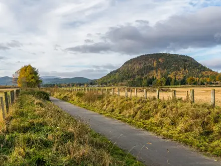
The official opening section crosses the Sonian Forest and south Uccle, including forest paths and a stretch following the old Brussels-Tervuren railway line.
A green corridor through the Woluwe valley park chain, linking landscaped parks, ponds and surfaced paths through the eastern side of Brussels.
This section links the Senne and Woluwe side of the loop, passing places such as Moeraske nature reserve, Schaerbeek railway station and Brussels Cemetery.
The route crosses the Heysel plateau near the Atomium and Brussels Expo, then skirts the Royal Domain of Laeken, Royal Greenhouses and nearby royal parkland.
A western section through the Molenbeek valley, including the Marais de Jette-Ganshoren wetland and King Baudouin Park.
The most rural-feeling part of the loop, passing the Pajottenland fringe around Neerpede, Lake Pede, farmland and the Luizenmolen windmill.
The final official section links the south-western green corridors between the Vogelzangbeek and Geleytsbeek, closing the loop back towards Uccle and the Sonian Forest side.
Reviews
How would you rate Brussels Green Walk?
Tap a star to start your review — you could be the first.