Berwickshire Coastal Path
How would you rate Berwickshire Coastal Path?
Tap a star to share your experience and help other hikers.
Berwickshire Coastal Path: Clifftop Walking on the Border Coast
HikeList Score
Berwickshire Coastal Path scored 79/100 on HikeList's trail-quality metrics.
See score breakdownHide breakdown
- Ideal length 66
- Balanced challenge 100
- Scenery & wildness 68
- Varied terrain 100
- Accommodation 75
- Food & support 74
- Path quality 84
- Season flexibility 89
Computed from length, challenge, scenery & wildness, terrain variety, accommodation, food & support, path quality and season flexibility.
The Berwickshire Coastal Path is a 48 km point-to-point walk from Cockburnspath in the Scottish Borders to Berwick-upon-Tweed in England. Usually walked north to south over 2-3 days, it is a moderate coastal trail with grassy clifftops, beaches, farmland edges and short paved village sections. It suits fit walkers who want dramatic sea cliffs without technical terrain. For more routes in Scotland, compare it with the Ayrshire Coastal Path or the island-based Arran Coastal Way.
Route Overview
Most walkers start in Cockburnspath and head south to Berwick-upon-Tweed, using the easier finish-town amenities and keeping the sun more often behind them. The official route is waymarked throughout with a white tilde (~) on a blue background. A typical 3-day split is Cockburnspath to Dowlaw via Cove, Pease Bay and Fast Castle; Dowlaw to Eyemouth via St Abb's Head, St Abbs and Coldingham Sands; then Eyemouth to Berwick-upon-Tweed via Burnmouth and the England/Scotland border. It is a point-to-point trail, so plan end-to-end logistics rather than expecting a loop. For another remote-feeling Scottish coastal option, see the Assynt Coastal Path.
Fishing Harbours, Fortresses and the Eyemouth Disaster
The route follows a coast shaped by fishing, smuggling and clifftop strongholds. Fast Castle was a medieval Home family fortress on a rocky promontory, while Cove and Eyemouth grew around fishing and contraband harbours. The path also passes communities marked by the Eyemouth disaster of 14 October 1881, when 189 local fishermen drowned in a sudden gale. Memorial statues at Eyemouth, Burnmouth, St Abbs and Cove commemorate the dead. Today, St Abb's Head and the wider coast are protected for seabirds and marine life.
Notable highlights
- St Abb's Head (National Nature Reserve): The standout headland on the route, with sheer cliffs and busy early-summer seabird colonies including guillemots, razorbills and kittiwakes.
- Fast Castle (clifftop ruins): Atmospheric remains of a fortress on a rocky promontory near Dowlaw, long associated with the Home family and linked to Scott's The Bride of Lammermoor.
- Eyemouth (fishing harbour town): A practical overnight stop and a place with strong maritime history, including memorials to the 1881 Eyemouth disaster.
- Coldingham Sands (Blue Flag beach): A sheltered sandy beach beside St Abbs, popular for swimming and surfing, and a gentler contrast to the cliff sections.
- St Abbs village (working harbour): A small fishing village with a working harbour, a voluntary marine reserve connection, and good chances of seeing coastal wildlife.
- Berwick-upon-Tweed (historic border town): The southern finish, known for its Elizabethan ramparts and three bridges over the River Tweed.
Challenges to expect
Expect moderate, exposed clifftop walking rather than technical hiking. The total ascent is 1,060 m, built up through repeated coastal rises and dips, with the highest point around 102 m at Blaikie Heugh. Some edges are exposed, and winter storms can make the cliffs wild and slippery. Surfaces vary from grass and dirt to rocky sections, beaches, field edges and short road or pavement stretches through villages.
HikeList Score
Berwickshire Coastal Path scored 79/100 on HikeList's trail-quality metrics.
See score breakdownHide breakdown
- Ideal length 66
- Balanced challenge 100
- Scenery & wildness 68
- Varied terrain 100
- Accommodation 75
- Food & support 74
- Path quality 84
- Season flexibility 89
Computed from length, challenge, scenery & wildness, terrain variety, accommodation, food & support, path quality and season flexibility.
Show more data Show less
- Coastal
- Clifftop
- Farmland
- Beaches
- Dirt
- Grass
- Rocky
- Paved
- Hotels
- Campsites
- Wild Camping Spots
- Family Friendly
- Dog Friendly On Leash
- Restrooms
- Public Transport Access Points
In these collections
Photos from hikers
Taken on the trail by people who've reviewed Berwickshire Coastal Path.
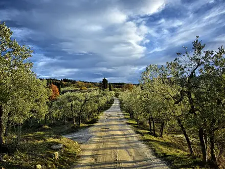
Start at Cockburnspath and follow the coast via Cove and Pease Bay, continuing past Fast Castle towards Dowlaw. This first stage introduces the mix of clifftop paths, field edges and coastal views.
The most dramatic section of the walk, crossing the St Abb's Head area before passing St Abbs and Coldingham Sands on the way to Eyemouth.
Leave Eyemouth and continue south via Burnmouth, crossing the England/Scotland border before finishing in Berwick-upon-Tweed.
Reviews
How would you rate Berwickshire Coastal Path?
Tap a star to start your review — you could be the first.