Wye Valley Walk
How would you rate Wye Valley Walk?
Tap a star to share your experience and help other hikers.
Wye Valley Walk: A Complete Hiking Guide
HikeList Score
Wye Valley Walk scored 93/100 on HikeList's trail-quality metrics.
See score breakdownHide breakdown
- Ideal length 92
- Balanced challenge 100
- Scenery & wildness 82
- Varied terrain 100
- Accommodation 100
- Food & support 94
- Path quality 92
- Season flexibility 89
Computed from length, challenge, scenery & wildness, terrain variety, accommodation, food & support, path quality and season flexibility.
The Wye Valley Walk is a 219 km (136-mile) waymarked point-to-point trail following the River Wye from its upland source near Plynlimon in Mid Wales to Chepstow on the Severn estuary. Most walkers take 10–12 days, though fast or leisurely schedules vary. It is a moderate long-distance walk: no scrambling or exposed ridges, but expect muddy paths, open moorland, steep rocky sections and climbs above the lower Wye limestone gorges. It suits hikers who want a borderlands river route across Wales and England.
Route Overview
Most walkers go north to south, starting at Rhyd-y-benwch / Coed Hafren in the Hafren Forest near Plynlimon and finishing at Chepstow Castle, where the Wye meets the Severn estuary. The route is waymarked both ways with yellow arrows and the leaping salmon logo, but the official guidebook runs Plynlimon to Chepstow. Key places include Llangurig, Rhayader, Builth Wells, Hay-on-Wye, Hereford, Ross-on-Wye, Symonds Yat, Monmouth, Tintern and Chepstow. It repeatedly crosses the Welsh-English border through Powys, Herefordshire, Monmouthshire and the Forest of Dean / Wye Valley area. As a point-to-point walk, plan transport to the remote northern start or onward from Chepstow. For comparison, see Beacons Way or the Anglesey Coastal Path.
History of the Wye Valley Walk
The Wye Valley Walk opened in 1975 with an initial 14-mile (23 km) section. It was extended through the 1980s to around 112 miles, then reached its full length when the route was pushed north to Plynlimon in September 2002. Today it is managed by the Wye Valley Walk Partnership, and Cicerone publishes the official guidebook. The route’s history explains its mix of established riverside walking, border towns and later upland stages near the river’s source.
Notable highlights
- Plynlimon source: The northern end begins near the remote upland source of the River Wye on Plynlimon (Pumlumon) in the Cambrian Mountains. The trail does not summit Plynlimon itself.
- Hay-on-Wye: A small border town on the river, known worldwide as the “town of books” and for its literary festival. It makes a useful and memorable mid-route stop.
- Hereford Cathedral and Mappa Mundi: Hereford lies on the route and its cathedral houses the Mappa Mundi, a rare medieval world map dating from around 1300.
- Symonds Yat Rock: A limestone viewpoint above a horseshoe bend of the Wye, known for wide valley views and peregrine falcons watched from the rock.
- Tintern Abbey: The roofless ruins of a 12th-century Cistercian abbey stand beside the river near Tintern, one of Britain’s best-known monastic ruins.
- Chepstow Castle: The walk finishes by this clifftop Norman stronghold above the Wye, begun in 1067 and one of Britain’s oldest surviving stone castles.
Challenges to expect
The Wye Valley Walk is moderate rather than technical, but the cumulative ascent is substantial at about 4,800 m. Expect a varied surface: riverside paths, field paths, woodland trails, quiet lanes and muddy hillsides after rain. Welsh stages include open upland moorland, while the lower valley adds steep climbs above limestone gorges. Winter can bring mud and flooding in valley sections. Waymarking is continuous, but carry maps or GPS for poor weather and rural junctions. If you prefer shorter day-walk planning, compare the Aber Falls Walk.
HikeList Score
Wye Valley Walk scored 93/100 on HikeList's trail-quality metrics.
See score breakdownHide breakdown
- Ideal length 92
- Balanced challenge 100
- Scenery & wildness 82
- Varied terrain 100
- Accommodation 100
- Food & support 94
- Path quality 92
- Season flexibility 89
Computed from length, challenge, scenery & wildness, terrain variety, accommodation, food & support, path quality and season flexibility.
 United Kingdom
 England
Show more data Show less
- Riverside
- Moorland
- Farmland
- Forest
- Limestone Gorges
- Footpaths
- Riverside Tracks
- Field Paths
- Woodland Trails
- Quiet Lanes
- Muddy After Rain
- B&Bs
- Small Hotels
- Inns
- Hostels
- Shepherd'S Huts
- Campsites
- Family Friendly
- Dog Friendly On Leash
- Restrooms
- Potable Water Sources
- Established Campsites
- Picnic Areas
- Public Transport Access Points
Download Our Full Guide to Wye Valley Walk FREE!
Get our comprehensive guide to this hike for free. Save it for later reading or print out at home.
In these collections
Photos from hikers
Taken on the trail by people who've reviewed Wye Valley Walk.
Wye Valley Walk: The Complete Guide
 i
Image by naturemalc
i
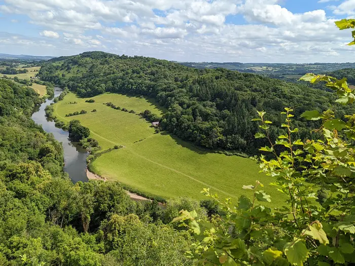
Image by naturemalc The Wye Valley Walk is a long, waymarked source-to-sea journey following the River Wye for 219 km (136 miles), from its source area near Rhyd-y-benwch in Hafren Forest to Chepstow Castle above the Severn estuary. It suits fit walkers who want a varied borderlands route rather than a technical mountain trail.
The character changes steadily as the river grows. The northern stages cross open Mid Wales moorland and rougher, wetter ground near Plynlimon/Pumlumon, before the route settles into pastoral valleys, riverside meadows and serviceable market-town stops through places such as Builth Wells, Hay-on-Wye, Hereford and Ross-on-Wye.
The lower Wye is the dramatic finale: limestone gorges, steep wooded valley sides, Symonds Yat Rock, Tintern Abbey and the final approach into Chepstow. The trail crosses between Wales and England repeatedly, linking Powys, Herefordshire, the Forest of Dean and Monmouthshire without ever feeling like a single-type walk.
This is a moderate long-distance hike, not a scramble, but it still asks for stamina, sensible planning and weather-aware navigation. Expect around 4,800–5,600 m of total ascent, possible boggy upland going in the north, muddy valley paths after rain and some steep climbs above the lower gorges.
This guide covers stages, days, accommodation, food, transport, terrain and common mistakes across the full route.
Stage-by-Stage Guide
The outline below uses the 7-stage structure most suitable for a strong end-to-end walker. The official Wye Valley Walk is divided into shorter sections, so these stages can be split where accommodation, public transport and fitness make that sensible.
Stage 1: Rhyd-y-benwch / Plynlimon to Rhayader — approx. 30 km
This is the wildest and most committing day of the route. It starts at Rhyd-y-benwch in Hafren Forest, near the source area of the River Wye, then crosses forest, moorland and upper-valley farmland before reaching Rhayader. The route does not climb the summit of Plynlimon/Pumlumon.
The first part to Llangurig is remote and can be slow underfoot. Expect boardwalk through mossy woodland, pine forest, open moorland, boggy ground, bracken in summer and rougher tracks around the watershed. Orange-stained streams, caused by copper-bearing rock, add interest early on, and the route also passes near the old lead and copper workings of Nant-yr-Eira Mine and Nant Iago Lead Mine.
Stay on the main path around the old mine workings. Shafts and spoil areas are hazardous, and this is not a place for off-route exploring.
After Llangurig the walking gradually becomes less wild, but this section still includes the high point of the whole trail, near Nantyhendy Hill at about 480 m. This is also one of the most sustained climbs on the walk, before the route drops towards Rhayader along the upper Wye.
There are no reliable food or water stops before Llangurig, and Llangurig itself has very limited services. Carry a full day’s food and enough water from the start. Do not assume a pub meal or shop will be available in Llangurig without checking opening times before travelling.
Rhayader is the first substantial service town on the route. It has shops, pubs, restaurants, takeaways, B&Bs, hotels, campsites and cash facilities, making it the first straightforward resupply point after the remote start.
Transport at the start needs planning. Rhyd-y-benwch has no nearby railway station; the usual approach is via Caersws, then bus connections towards Llanidloes and onward road access, or a taxi for the final leg. Rhayader has bus links towards Llanidloes and Builth Wells; check Traveline Cymru before relying on same-day connections.
Navigation is most awkward on this stage, especially in cleared forest areas and across moorland where waymarking can be sparse or hard to spot. A GPX track and OS mapping are strongly recommended. After heavy rain, boggy sections and forest paths can be slower than the distance suggests.
Stage 2: Rhayader to Builth Wells — approx. 22 km
This stage follows the upper Wye south through a mixture of riverside meadows, woodland, hillside paths and farmland. It is less remote than Stage 1, but the first half still has meaningful ascent and should not be treated as an easy recovery day.
From Rhayader to Newbridge-on-Wye the route uses woodland and hillside paths above the river, with around 510 m of ascent on the official section. This is the part of the stage with meaningful climbing rather than easy riverside walking.
The second half from Newbridge-on-Wye to Builth Wells is gentler, with easier gradients, open fields, woodland and several kilometres close to the Wye. Features on this part include the Estyn Wood boardwalks, the Hirnant brook footbridge, Goytre Wood, Plum Tree Pool and the rapids and pools at Penddol Rocks above the river.
Newbridge-on-Wye is the main mid-stage settlement, but services are limited. There is a pub, the New Inn, but walkers should still carry lunch and enough water unless opening times have been checked.
The route ends in Builth Wells at The Groe park, marked by the bronze Welsh Black bull sculpture. Builth Wells is a useful overnight stop with shops, a supermarket, pubs, cafés, B&Bs and hotels.
Public transport is better here than in the upper stages, though still rural. The X47 bus links Newbridge-on-Wye and Builth Wells, but it does not run on Sundays. Builth Road railway station is about 5 km north of town on the Heart of Wales line, and Cilmeri station is about 4 km west.
Watch for a tricky footbridge near Plum Tree Pool, which can be obscured by undergrowth, and take care on the brief B4358 road section. Mud is common after rain on woodland and field paths.
Stage 3: Builth Wells to Hay-on-Wye — approx. 29 km
This is a long rural stage through the middle Wye valley, linking Builth Wells, Erwood, Glasbury and Hay-on-Wye. The walking is quieter than the town-to-town endpoints suggest, with field paths, common land, bracken-covered commons and occasional road sections.
Leaving Builth Wells, the route crosses common land and small fields while the Wye widens through the valley. The high ground around Graig Allt-y-bont reaches about 380 m, and views begin to open towards the Black Mountains near Erwood.
Erwood and Glasbury are the main intermediate settlements, but both have limited services. Food and water should be planned in advance, and village opening hours should not be assumed.
The Erwood to Glasbury part is one of the easiest sections of the Wye Valley Walk, descending gently beside the widening river with only modest ascent. After Glasbury, the route leaves the river for the final miles into Hay-on-Wye, crossing common land before entering town.
Hay-on-Wye is a strong overnight stop with cafés, pubs, restaurants, shops and a good range of accommodation. It is also a natural mid-route rest or resupply point for many walkers.
Accommodation in Hay-on-Wye can be extremely tight during the Hay Festival in late May and early June. Book months ahead if walking around this period, or adjust the itinerary to avoid arriving during the busiest dates.
Navigation is generally less severe than on the Plynlimon stage, but field paths and common-land crossings still require attention. Bracken, mud and indistinct trods can make progress slower in summer growth or after rain.
Stage 4: Hay-on-Wye to Hereford — approx. 34 km
This is the longest of the 7-stage itinerary and is a prime candidate for splitting. It combines the official sections through Bredwardine and Byford before reaching Hereford, and includes a major climb over Merbach Hill.
The terrain is varied: field walking, country lanes, quiet hamlets, riverside sections and some road walking. The climb over Merbach Hill, at around 305 m, is steep enough to be a real effort on a long day, followed by a steep descent to Bredwardine on the Wye.
Merbach Hill is the main scenic high point of the stage, with wide views towards the Welsh hills and the Malverns in clear conditions. The bridleway over the hill may follow an old drovers’ route.
Bredwardine is the most useful intermediate stop and has the Red Lion Hotel for food and accommodation. Byford is a tiny hamlet with few services, so do not rely on it for supplies.
After Bredwardine, the walking becomes flatter through riverside farmland towards Byford and then on to Hereford. The final approach becomes increasingly suburban and urban as the route enters the city.
Hereford is the best resupply and recovery point on the route. It has supermarkets, restaurants, pubs, hotels, hostels, medical and gear services, laundry options and a mainline railway station on the Welsh Marches line.
Hereford Cathedral, home of the Mappa Mundi, is the main cultural landmark at the end of the stage. The city also has a bus station with local and wider connections.
Because of the distance, this stage should be planned around daylight, weather and accommodation availability. Carry enough food and water for the full day unless stopping in Bredwardine, and allow extra time for mud on field paths after rain.
Stage 5: Hereford to Ross-on-Wye — approx. 29 km
This stage moves through the gentler Herefordshire Plain before the valley becomes more wooded and enclosed towards Ross-on-Wye. It is generally less severe than the upper Welsh stages, but it is still a full day with a mix of riverside paths, farmland, meadows, woodland and lanes.
The first section from Hereford to Fownhope follows riverside and field paths. Fownhope is the main mid-stage settlement and has The Green Man Inn, a long-standing pub on the route, but other services are limited.
Beyond Fownhope, the route passes through woodland and farmland, including Lea and Pagets Wood SSSI, one of the notable broadleaved woodland areas in the Wye Valley. The route then returns towards the Wye around How Caple.
Capler Camp, an Iron Age hillfort at about 180 m, gives a short climb and good countryside views. The later part of the stage includes a narrow tarmac lane section towards Hole in the Wall, the area around Foy suspension bridge, and a mostly level final approach towards Ross-on-Wye, including a short section of old railway track.
Food and water planning is straightforward leaving Hereford, but there are limited options during the day. Carry lunch unless stopping in Fownhope, and check pub opening hours if depending on a meal.
Ross-on-Wye is a good overnight stop, with B&Bs, hotels, pubs, restaurants, tea shops and other town services. The Market House and views over the Wye are useful orientation points in town.
Ross-on-Wye has bus links towards Hereford and Monmouth, but no mainline railway station. The nearest mainline rail access is at Hereford, about 25 km to the north.
Navigation is usually less complex than on the upland sections, but woodland junctions, field exits and the lane section need care. Mud can be persistent after rain, especially through woods and farmland.
Stage 6: Ross-on-Wye to Monmouth — approx. 24 km
This is one of the most scenic stages of the walk, entering the classic lower Wye Valley landscape of wooded slopes, riverside meadows, limestone viewpoints and enclosed valley paths. It is shorter than several earlier days, but the terrain is more intricate than the distance suggests.
The route leaves Ross-on-Wye with an early climb towards Chase Hill, an Iron Age hillfort with views over the Wye Valley. It then uses a mix of paths and lanes around Leys Hill before descending towards Kerne Bridge.
At Kerne Bridge the route crosses the Wye. Goodrich Castle is visible nearby, and the medieval ruins can be visited by a short diversion of about 1 km.
After Kerne Bridge, the route follows the west bank of the Wye through riverside meadows towards Welsh Bicknor Church and the YHA hostel. Welsh Bicknor YHA is the key budget accommodation option on this section, in a riverside church conversion.
The route continues through the Lydbrook area, where services are limited, and passes below Coldwell Rocks. Peregrine falcons nest on these cliffs and are often seen soaring in spring and summer.
Symonds Yat Rock is the major viewpoint of the day, a limestone outcrop standing roughly 150 m (about 500 ft) above a horseshoe bend of the Wye. Reaching the viewpoint involves a short steep climb off the main trail, but it is one of the signature views of the entire walk. The RSPB runs a peregrine viewpoint here in season.
A hand-pulled ferry operates across the Wye at the foot of Symonds Yat Rock on a seasonal basis. This should be checked before travelling if it is being used for access, accommodation or a side trip.
Monmouth is a strong overnight stop with shops, pubs, restaurants, B&Bs and hotels. Monnow Bridge, the 13th-century fortified river bridge, is the town’s key landmark.
Public transport from Monmouth is by bus, with services towards Hereford and Chepstow. There is no mainline railway station in Monmouth; Chepstow is the nearest mainline rail option.
Navigation can be fiddly around wooded paths, lanes and riverside meadows, particularly where paths split near settlements and visitor areas. Expect mud after rain, and allow time if detouring to Goodrich Castle or Symonds Yat Rock.
Stage 7: Monmouth to Chepstow — approx. 27 km
The final stage follows the lower Wye gorge through some of the most dramatic woodland and limestone scenery on the route. It links Monmouth, Tintern and Chepstow, with sustained wooded walking and several climbs high above the river.
From Monmouth, the route climbs out of the valley onto wooded higher ground before descending to Tintern. Some terrain in this area is shared with, or close to, the Offa’s Dyke Path corridor.
Tintern is the main mid-stage stop and the most important landmark of the day. Tintern Abbey, a ruined 12th-century Cistercian abbey beside the river, is visible from outside, with entry applying for the interior. The village has pubs, cafés and accommodation.
The Tintern to Chepstow section is only about 9.6 km, but it has around 470 m of ascent and feels more demanding than the mileage suggests. After Tintern the route climbs through woodland past historic limekilns, Black Cliff and Wyndcliff Woods.
The Wyndcliff is the high point of this final section. The Eagle’s Nest viewpoint, at about 235 m (around 771 ft) above sea level, is the highest point on the Monmouthshire bank of the Wye and one of the best final-stage panoramas, before the route descends by the historic 365 steps to Lower Wyndcliff.
The route then passes through Piercefield Park, an 18th-century landscaped estate with historic viewpoints including The Lover’s Leap, The Giant’s Cave, The Grotto and The Alcove. The final approach drops through Castle Dell and urban roads into Chepstow.
There are no refreshments on the Tintern to Chepstow path itself. The Piercefield pub at St Arvans is off-route, while Chepstow has pubs, cafés and full town services on arrival. Carry enough water from Tintern, especially in warm weather.
Chepstow is the most convenient finish point for onward travel, with a mainline railway station on the Gloucester–Newport line. The walk finishes by Chepstow Castle, the Norman stronghold above the Wye near its meeting with the Severn estuary.
OS Explorer OL14 covers this lower Wye Valley section. Navigation is generally helped by defined woodland paths, but the climbs, steps, junctions and visitor-path networks around Wyndcliff and Piercefield require attention. In winter or after heavy rain, expect slippery woodland paths and possible flooding on lower riverside sections.
Recommended Itinerary
The most practical direction for an end-to-end Wye Valley Walk is source to sea, from Rhyd-y-benwch / Hafren Forest to Chepstow. This starts with the most remote logistics and finishes at Chepstow, where onward transport is much easier.
Distances below are approximate and should be checked against official mapping before booking accommodation, especially where the day is split around smaller villages with limited beds.
Standard itinerary: 11 days source to sea
This is the best balanced itinerary for most fit walkers. It avoids the very long 30 km-plus days in the condensed 7-stage version, keeps the remote northern section manageable, and gives sensible overnight stops in the main service towns where possible.
| Day | From | To | Approx. distance | Why this stage makes sense | Services/accommodation notes |
|---|---|---|---|---|---|
| 1 | Rhyd-y-benwch / Hafren Forest | Llangurig | ~19 km / 12 miles | A remote upland opening stage from the Wye source area, with open Welsh moorland and potentially boggy ground. Starting here keeps the first day demanding but not excessive. | Very limited services between the trailhead and Llangurig. Llangurig has a pub but limited accommodation, so book ahead and arrange transport to the start carefully. |
| 2 | Llangurig | Rhayader | ~19 km / 12 miles | Continues through the upper Wye country before reaching a proper service town. This is a more sensible split than trying to push from the source area to Rhayader in one day. | Rhayader is one of the best early stops, with accommodation, shops, pubs, restaurants and outdoor supplies. |
| 3 | Rhayader | Builth Wells | ~22 km / 14 miles | A moderate valley stage with easier riverside walking after the tougher upland start. Newbridge-on-Wye gives a useful mid-stage landmark. | Newbridge-on-Wye has limited services. Builth Wells has shops, pubs, a supermarket and accommodation; Builth Road station is about 2 miles away. |
| 4 | Builth Wells | Erwood or Glasbury | ~16–20 km / 10–12 miles | A shorter rural day through river and farmland country, useful after three continuous walking days. The exact stop depends on where accommodation is available. | Erwood is very limited. Boughrood has a village shop and pub over the bridge; Glasbury has a café, service station, pub and limited accommodation. Book early. |
| 5 | Erwood or Glasbury | Hay-on-Wye | ~10–15 km / 6–9 miles | A deliberately short day into Hay-on-Wye, allowing time for resupply, rest and a more relaxed town stop. | Hay-on-Wye has a good range of accommodation, restaurants, bookshops and campsites. During Hay Festival and busy spring/summer weekends, accommodation should be booked months ahead. |
| 6 | Hay-on-Wye | Bredwardine or Monnington-on-Wye | ~16–22 km / 10–14 miles | This breaks the long Hay-on-Wye to Hereford section into a manageable rural stage across quieter border farmland. | Services are sparse between Hay and Bredwardine. Bredwardine and Monnington-on-Wye have very limited accommodation, so availability may decide the exact stopping point. |
| 7 | Bredwardine or Monnington-on-Wye | Hereford | ~12–22 km / 8–14 miles | A flexible approach into the only city on the route, passing through a quieter stretch before reaching full services. | Byford has limited services. Hereford has extensive accommodation, restaurants, shops, outdoor supplies and strong rail connections. |
| 8 | Hereford | Fownhope or Ross-on-Wye | ~18–29 km / 11–18 miles | A flexible day through meadows, orchards, riverside paths and some valley-side climbs. Strong walkers can continue to Ross-on-Wye; others can stop at Fownhope. | Fownhope has limited accommodation, including a pub with rooms. Ross-on-Wye has a better range of places to stay, shops and food options. |
| 9 | Ross-on-Wye | Symonds Yat | ~16–20 km / 10–13 miles | This stage brings the route into the lower Wye gorge landscape, via Kerne Bridge and towards Symonds Yat. It is one of the most scenic sections of the walk. | Kerne Bridge and Symonds Yat have limited accommodation, so booking ahead is important. Symonds Yat is a popular stop, particularly in good weather and at weekends. |
| 10 | Symonds Yat | Monmouth | ~14 km / 8–9 miles | A shorter day after the gorge section, giving time for the viewpoint area around Symonds Yat Rock before continuing to Monmouth. | Monmouth has good services, several accommodation options and a campsite near Monnow Bridge. It is a useful final major resupply point before Chepstow. |
| 11 | Monmouth | Chepstow via Tintern | ~27 km / 17 miles | A strong final day through the lower Wye Valley, including Tintern and the approach to Chepstow Castle. Do not underestimate the Monmouth to Tintern section: it includes around 400 m of ascent. | Tintern has limited accommodation if this day needs splitting. Chepstow has good accommodation and rail connections for onward travel. |
Slower variant: 12–14 days
A slower schedule suits walkers who prefer shorter days, want more time in Hay-on-Wye, Hereford or Monmouth, or are carrying full camping kit. It also reduces pressure on the tougher final stages through the Wye gorge.
The simplest approach is to follow more of the official short-stage structure, which divides the route into 17 sections of roughly 5–12 miles. Useful extra overnight stops include Newbridge-on-Wye, Glasbury, Fownhope, Kerne Bridge, Symonds Yat and Tintern, subject to accommodation availability.
A practical slower adjustment is:
- Break Rhayader to Builth Wells with an overnight around Newbridge-on-Wye.
- Keep the Builth Wells to Hay-on-Wye section split around Erwood or Glasbury.
- Stop at Fownhope between Hereford and Ross-on-Wye instead of walking the full stage in one day.
- Split the final section with a night in Tintern, then walk the remaining ~10 km to Chepstow the next day.
This version is more forgiving, but it depends heavily on small-place accommodation. Village services can be very limited, and shops or pubs should not be assumed without checking before travelling.
Faster variant: 7–8 days
A 7–8 day itinerary is only sensible for experienced long-distance walkers who are comfortable with repeated days of around 27–30 km, occasional longer pushes and fewer recovery opportunities. It follows the condensed stage pattern more closely.
| Day | From | To | Approx. distance | Why this stage makes sense | Services/accommodation notes |
|---|---|---|---|---|---|
| 1 | Rhyd-y-benwch / Hafren Forest | Rhayader | ~30 km / 19 miles | A long, remote opening day across upland terrain. This is demanding and should not be treated as an easy first stage. | Very limited services until Rhayader. Transport to the start must be arranged in advance. |
| 2 | Rhayader | Builth Wells | ~22 km / 14 miles | A more moderate day after the hard opener, following the Wye valley towards a full-service town. | Builth Wells has accommodation, shops, pubs and access to Builth Road station. |
| 3 | Builth Wells | Hay-on-Wye | ~29 km / 18 miles | Combines the rural Erwood/Glasbury section into one longer day, avoiding a small-place overnight. | Hay-on-Wye has strong services, but festival periods and weekends require early booking. |
| 4 | Hay-on-Wye | Hereford | ~34 km / 21 miles | The longest day in the condensed schedule, crossing quieter border farmland before reaching the city. | Services are limited between Hay and Hereford. Hereford has the best mid-route transport and accommodation choice. |
| 5 | Hereford | Ross-on-Wye | ~29 km / 18 miles | A long but straightforward stage through meadows, orchards and woodland, with the option to stop at Fownhope if needed. | Ross-on-Wye has good accommodation and food options. Fownhope is the main fallback but has limited beds. |
| 6 | Ross-on-Wye | Monmouth | ~24 km / 15 miles | Takes in the lower Wye scenery around Kerne Bridge and Symonds Yat before continuing to Monmouth. | Symonds Yat and Kerne Bridge have limited accommodation if the day needs shortening. Monmouth has better services. |
| 7 | Monmouth | Chepstow | ~27 km / 17 miles | A tough final day via Tintern, with notable ascent before the finish at Chepstow. | Tintern is the natural split point if the final day proves too hard. Chepstow has rail connections and a good choice of accommodation. |
For an 8-day version, the best place to add a day is usually the first stage or the final stage: split Rhyd-y-benwch to Rhayader at Llangurig, or split Monmouth to Chepstow with a night in Tintern. Both options make the walk substantially more comfortable without changing the overall source-to-sea line.
Planning the Route
How many days to allow
Most walkers should plan the Wye Valley Walk as a 10–12 day hike. That gives enough time for the long northern stages, the towns along the middle Wye and the steeper woodland and gorge walking in the south without turning every day into a forced march.
The official guide suggests roughly 10 days end to end, while the official route is also split into 17 shorter stages of about 4–12 miles each. Most independent thru-hikers combine two or three of those short official stages into a walking day, using towns and accommodation rather than the official stage breaks as the main planning structure.
| Pace | Typical plan | Best for |
|---|---|---|
| Fast | 7–8 days | Very fit walkers happy with long days and limited spare time |
| Standard | 10–12 days | Most experienced long-distance walkers |
| Comfortable | 13–16 nights | Easier pacing, more time in towns, less pressure on the upland days |
| Slow / sectional | Up to 18 stages | Walkers using the official short-stage structure or adding rest days |
A recognised Prologue from Llanidloes to Rhyd-y-benwch adds about 13 km for walkers arriving by public transport and wanting to walk into the official start. With this included, the route can be treated as an 18-stage journey of about 146 miles / 235 km.
Let accommodation shape the itinerary
Daily stages are strongly dictated by where beds are available, especially between Rhyd-y-benwch, Llangurig, Rhayader and Builth Wells. The northern part has longer gaps, fewer services and more exposed ground, so it is the section where loose planning causes the most problems.
The bigger planning anchors are Rhayader, Builth Wells, Hay-on-Wye, Hereford, Ross-on-Wye, Monmouth, Tintern and Chepstow. These are the places to build an itinerary around first, then adjust the in-between days with B&B pick-ups, taxi shuttles or shorter/longer walking days.
Hay-on-Wye is a natural mid-route pivot with accommodation, shops and transport options. Hereford is the strongest resupply and rail-access point on the route, and the most useful place for splitting the walk.
Book accommodation early. The Hay Festival in late May or early June can fill the Hay-on-Wye area completely, while the Royal Welsh Show at Builth Wells in July places heavy pressure on accommodation across the surrounding area.
Many B&Bs and small places to stay will collect walkers from the route and drop them back the next morning. This is worth asking about when booking, particularly in the sparse northern stages and around awkward stage ends.
Camping is possible, but campsites do not fall neatly at every sensible walking-day finish. A camping itinerary needs the same advance checking as a B&B itinerary rather than assuming there will be a convenient site at the end of each day.
Fast or slow?
The route can be walked quickly, but it is not at its best as a race. The easier riverside and field sections can make high-mileage days tempting, but the cumulative ascent, mud after rain and occasional steep climbs above the lower Wye can make repeated long days tiring.
A 10-day schedule is realistic for fit walkers carrying light kit or using baggage transfer. An 11–13 day plan is more forgiving and gives better margins for poor weather, slow going on the uplands and time in places such as Hay-on-Wye, Hereford, Symonds Yat, Tintern and Chepstow.
The main place not to underestimate is the opening section from Rhyd-y-benwch to Llangurig, which is remote and has no services until Llangurig. The following stretch over Nantyhendy Hill, the trail’s high point at about 480 m, is also one of the more demanding parts of the walk.
Direction of travel
The standard direction is source to sea, from Rhyd-y-benwch / Hafren Forest to Chepstow. This matches the usual presentation of the route and gives a satisfying finish at Chepstow Castle above the lower Wye.
The walk is waymarked in both directions, so a south-to-north itinerary is possible. The trade-off is that the remote Hafren Forest end then becomes the final transport problem rather than the first one.
For most walkers, source-to-sea is the cleaner choice: deal with the awkward northern access at the start, then finish with easier rail and coach options from Chepstow.
Food, water and resupply
Do not rely on every village having an open shop or pub. Village services and pub hours can change, and closures have become more common; check each planned stop before travelling.
The most reliable service towns are Rhayader, Builth Wells, Hay-on-Wye, Hereford, Ross-on-Wye, Monmouth, Tintern and Chepstow. Hereford is the best full resupply point, with the broadest range of shops and strong rail links.
Villages such as Llangurig, Newbridge-on-Wye, Glasbury, Fownhope, Kerne Bridge and Symonds Yat may offer a pub, café or small shop, but they should not be treated as guaranteed resupply points without checking current opening.
The critical food-and-water gap is the opening moorland section from Rhyd-y-benwch to Llangurig, where there are no services. Carry enough food and water for the full stage.
Between Hay-on-Wye and Hereford, refreshment opportunities can also be sparse. In warm weather, start that section with enough water rather than planning around uncertain stops.
Transport and baggage planning
The northern start needs deliberate planning. The usual public-transport approach is via Caersws station on the Cambrian Main Line, then bus to Llanidloes and taxi onwards to Rhyd-y-benwch. Some walkers avoid the final taxi by adding the Llanidloes–Rhyd-y-benwch Prologue as a Day 0.
The southern finish is much easier. Chepstow station is on the Gloucester–Newport line, with onward connections towards Bristol, Cardiff and London, and National Express coaches also serve Chepstow.
For section hikers, the most useful rail points are Hereford, Builth Road and Cilmeri. Builth Road and Cilmeri are on the Heart of Wales line and are several kilometres from Builth Wells, with limited frequency, so timetables and onward arrangements should be checked before travelling.
Baggage transfer can make the route more manageable, but coverage varies by area. WALKlite covers the southern Wye Valley Walk between Chepstow and Hay-on-Wye, Eco Carriers operates around Kington, Kenny’s Taxis covers the River Wye corridor, and Hay Taxibus is useful around Builth, Hay-on-Wye, Bredwardine and Hereford. Book ahead and confirm current coverage, prices and pick-up rules before relying on any operator.
Section hiking options
Section hiking is practical, especially because Hereford provides the best mid-route rail access and a natural dividing point.
| Section | Character | Planning notes |
|---|---|---|
| Rhyd-y-benwch to Hereford | Wilder northern and middle Wye, about 90 miles / 145 km | More remote, more accommodation planning, harder start access |
| Hereford to Chepstow | Lower Wye, gorges, Tintern and Chepstow, about 46 miles / 74 km | Easier logistics, suitable for 3–5 days depending on pace |
| Hay-on-Wye to Hereford | Middle Wye section | Works well as a 2–3 day short break |
| Tintern to Chepstow | Popular short southern section | Good for a weekend or final 1–2 day sample of the route |
The southern half is easier to sample because towns and transport are closer together. The northern section is more committing and benefits from the same preparation as a full thru-hike.
Navigation and route-finding
The Wye Valley Walk is waymarked with the leaping-salmon logo and yellow arrows, but the waymarking should not be treated as the only navigation tool. Posts can be missed, and field paths, woodland turns and riverside alternatives are easier to follow with a map or GPS backup.
Carry proper mapping for the whole route. OS Explorer mapping at 1:25,000 is the best scale for field paths and access details, while the Cicerone guide includes 1:50,000 OS mapping and a facilities planner.
A GPS app with offline OS mapping is useful, particularly in the upper stages and in poor visibility. The official GPX route is available from the Wye Valley Walk website.
Weather and seasonal timing
The best windows are usually late April to May and September to October. Spring brings flowers and longer daylight, while early autumn is often quieter and less pressured for accommodation.
Summer is straightforward underfoot in good weather but busier for beds, especially around Hay-on-Wye and Builth Wells during major events. Book much earlier if walking in late May, June or July.
Winter is possible on some valley sections but is not the best time for the full route. The upper moorland can be boggy and exposed, and river flooding can affect low-lying paths along the Wye.
After prolonged rain, expect mud on field paths and slippery woodland climbs, particularly in the lower gorge sections around Symonds Yat and Tintern. Check river conditions before departure in winter and spring; riverlevels.uk is a useful planning check.
Permits and access
No permits are required for the Wye Valley Walk, and there are no toll crossings to plan around. Some sections cross private farmland on public rights of way, so keep to the signed line, close gates and take extra care around livestock.
The essential planning tasks are therefore practical rather than bureaucratic: secure beds early, check village services, carry enough food and water for the sparse northern stages, arrange start and finish transport, and take reliable backup navigation.
Towns, Villages and Overnight Stops
Accommodation and food are unevenly spaced on the Wye Valley Walk. The main overnight hubs are Rhayader, Builth Wells, Hay-on-Wye, Hereford, Ross-on-Wye, Monmouth, Tintern and Chepstow; the smaller river villages are useful for lunch stops or breaking long days, but cannot always be relied on for supplies.
Book early for Hay-on-Wye during the Hay Festival in late May, Builth Wells during the Royal Welsh Show in late July, and Tintern or Symonds Yat in busy summer periods. Village pubs and shops can change hands or close, so opening days and food service should be checked before travelling.
Rhyd-y-benwch / Hafren Forest
Rhyd-y-benwch car park in Hafren Forest is the remote northern start, near the source area of the River Wye on Plynlimon / Pumlumon. It is a trailhead rather than a settlement, with no café, shop, pub or accommodation at the start.
Arrive with food, water and bad-weather kit already sorted, as walkers need to be self-sufficient until Llangurig. The nearest services are at Llangurig, roughly 7–8 km away by road, or Llanidloes, roughly 16 km away.
There is no public transport to the start. Most walkers use a car, taxi or pre-arranged transfer; Caersws on the Cambrian line is the usual rail approach, with onward travel by bus or taxi to Llanidloes and then to the forest.
Llangurig
Llangurig is the first village with services after leaving Hafren Forest, sitting on the A470/A44 early in the route. It is the natural first-night stop for walkers splitting the long opening stage to Rhayader into two shorter days.
Facilities are limited but useful: the Blue Bell Inn offers B&B accommodation, the village has a shop and Post Office, and there is a café and at least one pub. Treat it as the first dependable resupply point rather than assuming anything at the trailhead.
Buses serve Llangurig on routes connecting Llanidloes and Rhayader; current times should be checked with Traveline Cymru. It is also a sensible pick-up or drop-off point for walkers arranging a shorter first day.
Rhayader
Rhayader is the first market town on the walk and one of the key early overnight stops. It has a strong choice of hotels, B&Bs, campsites and self-catering accommodation, making it much more reliable than the smaller settlements north of here.
Food options are good, with traditional pubs, cafés and restaurants. The Triangle Inn and The Crown are among the town’s pub options, and the independent shops make Rhayader a practical place to restock before continuing down the valley.
Rhayader is also the gateway to the Elan Valley reservoirs and dams, so it works well for a rest afternoon or a short detour if time allows. Buses connect north towards Llanidloes and Llangurig and south towards Builth Wells; check Traveline Cymru for current services.
Newbridge-on-Wye
Newbridge-on-Wye is a small village between Rhayader and Builth Wells, useful mainly as a mid-stage stop. The New Inn provides a pub option, but accommodation and other services are limited.
Most end-to-end walkers continue to Builth Wells, around 8–10 km further south. Newbridge is best treated as a lunch or refreshment possibility rather than a full overnight hub.
Builth Wells
Builth Wells is the second major overnight stop and a practical base after the Rhayader stage. The route passes through town, and accommodation includes B&Bs, hotels and guesthouses; The Owls B&B specifically caters for Wye Valley Walk walkers.
The town has pubs, independent shops, food options and the Wyeside Arts Centre with a café. It is a good place to resupply before the stretch towards Hay-on-Wye, where facilities become more intermittent.
Builth Road station on the Heart of Wales line is about 4–5 km from town, with Cilmeri station also nearby. Bus services run on the Rhayader–Brecon corridor, and Hay Taxibus covers the Builth-to-Hereford corridor.
Accommodation should be booked well ahead if walking during the Royal Welsh Show, usually in late July. The town fills quickly during show week.
Erwood
Erwood is a small hamlet south of Builth Wells. It has very limited facilities, with Erwood Station Craft Centre & Gallery operating seasonally and few other services for walkers.
It is not a realistic overnight stop for most itineraries unless specific accommodation has been arranged in advance. Carry food and do not plan the day around finding a full range of services here.
Glasbury
Glasbury sits on the Wye just north of Hay-on-Wye. It has some accommodation nearby and the River Café is a well-known stop for walkers and canoeists.
For most end-to-end schedules, Glasbury is a useful pause rather than the day’s endpoint. Hay-on-Wye offers a much broader choice of beds, food and shops a short distance further on.
Hay-on-Wye
Hay-on-Wye is one of the best overnight stops on the entire route and a major resupply point. It sits on the Wales–England boundary and is known for its second-hand and antiquarian bookshops, but for walkers its main value is the combination of accommodation, food and transport options.
Accommodation ranges from hotels, B&Bs and guesthouses to camping and glamping-style options such as Outdoors@Hay. The town books up quickly during the Hay Festival in late May and during other literary events, so reservations are essential in those periods.
Food and drink options are strong, with pubs, restaurants, bistros, cafés and a Thursday market. The Old Black Lion is one pub-with-rooms option, and the town’s independent shops make it a good place to restock before the long stage towards Hereford.
Hay has no rail station. Buses connect with Hereford, Brecon and Builth Wells, and Hay Taxibus covers the Builth-to-Hereford corridor; current services should be checked before travelling. The Offa’s Dyke Path also intersects the route here, and Hay Bluff is accessible for a rest-day walk.
Bredwardine
Bredwardine is a small village on the Hay-on-Wye to Hereford section. It is not a major stop, but the Red Lion hotel/pub makes it a useful lunch stop or possible emergency overnight option.
Facilities beyond the pub are limited, so do not rely on Bredwardine for a full resupply. The village church, St Andrew’s, is known for its connection with Victorian diarist Rev Francis Kilvert, who is buried there.
Byford
Byford is a very small village passed on the way to Hereford. It has no significant walker facilities and should not be planned as a food, drink or accommodation stop.
This part of the route is better planned around confirmed stops such as Bredwardine and Hereford. Carry enough food and water for the day, especially if walking outside pub opening hours.
Hereford
Hereford is the only city on the Wye Valley Walk and the strongest service point on the route. It is an excellent overnight or rest-day stop, with hotels, B&Bs, hostels and high street accommodation options.
For resupply, Hereford is the best place on the walk. Supermarkets include Tesco, Waitrose, Asda, Sainsbury’s, Aldi, Morrisons and Lidl, and the city also has pharmacies, outdoor or general retail options, cafés, pubs and restaurants.
Hereford Cathedral, the Mappa Mundi and the Chained Library are the main cultural stops, with the Museum of Cider another option if taking time off the trail. Church Street has independent shops including Mousetrap Cheese Shop.
Hereford railway station is on the Welsh Marches line, with direct trains to Cardiff, Newport, Shrewsbury, Crewe and Birmingham, and good onward connections. It is the best place for joining, leaving or pausing the walk midway.
Fownhope
Fownhope is a village south of Hereford and the main practical stop on the Hereford to Ross-on-Wye stage. The Green Man pub welcomes walkers and has rooms, making it useful for breaking this stage into two easier days.
Other services in the village are limited. Between Hereford and Ross-on-Wye, many river-level settlements offer little or nothing for walkers, so plan food and water accordingly.
Ross-on-Wye
Ross-on-Wye is a key overnight stop and a good resupply town before the lower Wye gorge sections. Accommodation includes B&Bs, country house hotels and inns, with central options close to shops and pubs.
The town has a useful range of food and drink, including pubs such as The Man of Ross and The King’s Head, restaurants, cafés and nearby gastropubs. Markets run on Thursdays and Saturdays, and the town centre has independent shops, antiques, vintage stores and local arts and crafts at the Market House.
Ross has no railway station; the nearest rail access is Hereford, roughly 16 km north. Bus connections include the Number 34 bus towards Kerne Bridge, and National Express coach connections also serve the town.
It is a sensible rest-day base if the schedule allows, particularly for walkers wanting time off before the Monmouth stage. The Forest of Dean is accessible for side trips.
Kerne Bridge
Kerne Bridge is a small crossing point on the Wye south of Ross-on-Wye. It is not a full-service village, but it has useful accommodation options for walkers who want to break the Ross-to-Monmouth stage.
The Inn on the Wye is a hotel/pub at Kerne Bridge, and YHA Welsh Bicknor lies between Kerne Bridge and Symonds Yat as a budget option. Other facilities are limited, so food and onward logistics should be planned in advance.
Symonds Yat
Symonds Yat is one of the main scenic stops in the lower Wye Valley, set around a horseshoe bend of the river. Symonds Yat Rock is the key viewpoint, known for views over the gorge and for peregrine falcons in spring and summer.
Facilities include pubs, cafés and some seasonal accommodation, but it is not a large overnight hub. It can be busy with day visitors, especially in good weather and holiday periods.
Symonds Yat East and West are separated by the river, with a hand-pulled chain ferry operating seasonally. Do not base essential logistics on the ferry without checking current operation first.
Monmouth
Monmouth is a historic market town at the confluence of the Wye and Monnow rivers and one of the main overnight stops in the southern half of the walk. It has a good range of hotels, B&Bs and guesthouses for a town of its size.
The high street has pubs, independent shops and places to eat, making Monmouth a useful resupply point before the more secluded stage towards Tintern. The Savoy Theatre, Monnow Bridge, Monmouth Castle, Castle House museum and The Kymin are the main local points of interest.
There is no railway station in Monmouth. Buses connect with Hereford, Abergavenny, Chepstow and Newport; the nearest rail stations are Abergavenny, about 16 km away, and Chepstow, about 27 km away.
Tintern
Tintern is a village in the Wye gorge and one of the most popular overnight or final-stage stops. The ruins of Tintern Abbey dominate the village; it is a Cadw site with an admission charge, so opening times and dates should be checked before visiting.
Accommodation includes inns, B&Bs and guesthouses. The Wye Valley Hotel is a family-run inn with eight en-suite rooms, meals and breakfasts, and welcomes walkers, cyclists and dogs.
There are pubs and cafés in Tintern, with Old Station Tintern tearoom operating seasonally. Village shops are limited, so major resupply is better done in Monmouth or Chepstow.
Tintern has no railway station; Chepstow, about 11 km south, is the nearest rail access. Buses connect Tintern with Chepstow and Monmouth, but current services should be checked with Traveline before relying on them.
Chepstow
Chepstow is the finish of the Wye Valley Walk, with the route ending beside Chepstow Castle above the river. It is a good place to stay after completing the trail, particularly if finishing late in the day.
Accommodation includes B&Bs, hotels and pubs with rooms; The Three Tuns is a 16th-century inn next to Chepstow Castle. The town has pubs, cafés, restaurants and enough shops for last-day or onward-travel needs.
Chepstow has the best end-of-route transport links. Chepstow railway station is around a five-minute walk from the town centre on the Gloucester–Newport line, with direct services to Newport, Cardiff Central and Gloucester, and connections at Newport for London Paddington, Bristol, Swansea and wider Wales.
National Express coaches and local buses also serve Chepstow. Train services to Newport and Cardiff are frequent enough that many walkers can finish and travel the same evening, but staying overnight makes the end of the walk less rushed.
Getting to the Start
The official source-to-sea start is Rhyd-y-benwch car park in Hafren Forest, near the source area of the River Wye on Plynlimon / Pumlumon. It is a remote trailhead about 6–7 miles west of Llanidloes, with no refreshments and no reliable phone signal, so transport needs arranging before arrival.
Useful navigation details for the trailhead are OS grid reference SN 857 869 and What3Words trace.mostly.senders. The postcode SY18 6PT covers a wide area and should not be relied on for precise navigation to the car park.
By train
The nearest practical rail station for the northern start is Caersws, on the Cambrian Line between Shrewsbury, Machynlleth, Aberystwyth and Pwllheli. Llanidloes itself has no railway station.
Most rail approaches work through Shrewsbury, with onward Transport for Wales services to Caersws. Trains between Shrewsbury and Caersws are roughly every two hours and take about 44 minutes, but this should be checked before travelling.
From Caersws, take the X75 bus towards Llanidloes, or arrange a taxi onwards. Caersws is about 9–10 miles north-east of Llanidloes, so walking from the station to the start is not a realistic first-day approach for most end-to-end walkers.
| Rail approach | Practical onward plan |
|---|---|
| Birmingham / West Midlands | Train to Shrewsbury, then Cambrian Line to Caersws |
| London / South-east England | Usually via Birmingham or another mainline connection to Shrewsbury, then Caersws |
| North-west England | Train to Shrewsbury, then Cambrian Line to Caersws |
| South Wales / Bristol area | More awkward for the northern start; often easier for Chepstow or southern section starts |
For section hikers, Builth Road and Hereford are useful rail gateways farther down the route, but they are not convenient for reaching Rhyd-y-benwch. Chepstow has good rail access for the finish and is usually the simplest place to travel home from after completing the walk.
By bus
The key bus service for the start area is the X75, operated by Celtic Travel, linking Shrewsbury, Welshpool, Newtown, Caersws, Llanidloes and Llangurig, with some journeys continuing towards Aberystwyth. It runs Monday to Saturday with multiple journeys per day, but timetables should be checked before travelling.
Important stops for Wye Valley Walk logistics include Caersws Buck Inn, Llanidloes Gro and Llangurig Black Lion. Llangurig is on the early part of the route and can be useful for section hikers, but no public bus goes into Hafren Forest to Rhyd-y-benwch.
From Llanidloes to Rhyd-y-benwch, the normal options are:
- pre-booked taxi or lift;
- walking the Severn Way prologue from Llanidloes;
- starting from Llangurig only if deliberately modifying the route.
The official Wye Valley Walk website describes a Severn Way prologue from Llanidloes to Rhyd-y-benwch: about 8 miles / 12.9 km, taking roughly 2 hours 45 minutes, with around 570 ft of ascent. This is a practical way to avoid taxi dependency, but there are no refreshments en route and water should be carried.
Taxi planning matters here. There is no phone signal at Rhyd-y-benwch, so taxis must be arranged in advance from Llanidloes or through accommodation. The official Wye Valley Walk transport page lists Kenny's Taxis for River Wye areas on 07828 882432; local Llanidloes taxi operators can also be arranged through accommodation.
Traveline Cymru and Traveline England are useful for current public transport planning. Bus times and stopping patterns should be checked before travelling.
By car
Drivers should aim for Hafren Forest / Rhyd-y-benwch car park, approaching from Llanidloes on narrow country roads towards the Staylittle / Dylife direction. Natural Resources Wales advises using the grid reference or What3Words rather than relying on the broad SY18 6PT postcode.
There is free parking at Rhyd-y-benwch, but overnight parking is not permitted. That makes it unsuitable as a place to leave a vehicle for the full Wye Valley Walk.
Common car-based strategies are:
| Strategy | Why it works | Main caution |
|---|---|---|
| Park at Chepstow, travel to the start, then walk back to the car | Simplest at the finish, with rail access and town facilities | Long-stay parking rules and charges must be checked before travelling |
| Park in Llanidloes, take a taxi or walk the prologue to Rhyd-y-benwch | Keeps the car near the start and avoids leaving it in the forest | Return from Chepstow to Mid Wales is more involved |
| Get dropped at Rhyd-y-benwch | Best for avoiding parking complications | Must be arranged in advance because there is no phone signal at the trailhead |
In Chepstow, Monmouthshire Council operates town car parks, including Nelson Street, which is nearest the route, and Welsh Street, the largest. Current long-stay rules and tariffs should be checked before booking a multi-day or multi-week stay.
From the nearest airport
Birmingham Airport is usually the most practical airport for the northern start. Rail connections run via Birmingham New Street or directly onward towards Shrewsbury, then by Cambrian Line train to Caersws; Birmingham to Caersws is typically around 2–2.5 hours by rail, but this should be checked before travelling.
Manchester Airport is also workable, with rail connections to Shrewsbury, direct or with one change, then onward to Caersws. The total rail journey is roughly 3 hours in favourable connections.
Cardiff Airport and Bristol Airport are less convenient for Rhyd-y-benwch because they sit much closer to the southern end of the walk. They are more useful for walkers starting from Chepstow or tackling southern sections.
There are no commercial scheduled airports in Mid Wales close to Plynlimon / Pumlumon.
Where to stay before starting
Llanidloes is the natural pre-walk base. It has accommodation, pubs, cafés and shops, and it is close enough to Rhyd-y-benwch for a short pre-booked taxi transfer or for walking the Severn Way prologue.
Accommodation in Llanidloes includes B&Bs, small hotels and pubs with rooms, such as the Red Lion Hotel and Unicorn Hotel. Booking ahead is sensible, especially if also asking the accommodation to help arrange a morning taxi to the trailhead.
Use Llanidloes to buy food and any last supplies. Rhyd-y-benwch has no refreshments, and the first stage begins in a remote upland forest setting where missed logistics are hard to fix.
Llangurig is another possible stop for walkers adapting the first stage. The Bluebell Inn is a walker-friendly B&B option, and the village is served by the X75 bus, but it is not the official start; Rhyd-y-benwch remains more than 4 miles away.
Getting Home from the Finish
The Wye Valley Walk finishes at the stone marker in Castle Dell beside Chepstow Castle, above the River Wye near the Severn estuary. This is a very practical end point: the town centre, station, bus station, taxis, pubs and accommodation are all close to the finish.
If travelling home the same day, check onward services before committing to a late finish, especially on Sundays. Many walkers are better off staying in Chepstow and travelling the following morning, particularly after the longer Monmouth–Chepstow final stage or if arriving tired in the late afternoon.
By train
Chepstow station is on Station Road and is an easy walk from the town centre. It sits on the Gloucester–Newport line and has a taxi rank directly outside, making it the simplest public-transport exit from the route.
The ticket office keeps limited hours on weekdays and Saturday mornings and is closed on Sundays; exact times change, so this should be checked before travelling. Ticket machines are available outside those hours, but Sunday and late-evening travel should be checked before travelling.
| Destination | Typical route from Chepstow | Notes |
|---|---|---|
| Newport | Direct train | Around 23 minutes; useful for GWR high-speed services towards London and other connections. |
| Cardiff Central | Direct train | Usually around 31–45 minutes, with Transport for Wales and CrossCountry services. |
| London Paddington | Change at Newport | Fastest journeys are about 2 hours 8 minutes; many services take longer depending on the connection. |
| Bristol Temple Meads | Change required | There are no direct trains to Bristol; connections are usually via Newport or Gloucester. |
| Gloucester | Direct train | Useful for onward travel north or into the Midlands and south-west. |
Train frequencies and last services vary by day, so use National Rail or the train operator’s live timetable before booking accommodation, onward tickets or a taxi pickup.
By bus
Chepstow bus station is on the Tesco access road, a short walk from the town centre and station. Local and regional buses are useful if returning to a nearby stage end, reaching Bristol without a train change, or connecting to Newport.
Key services include:
- T7 — Chepstow to Cribbs Causeway and Bristol city centre, via Magor. This can be useful for Bristol when a direct train is not available.
- 65 — Chepstow to Monmouth via Trellech, Penallt, The Narth, Devauden and Itton. Useful if a car has been left at Monmouth or if section-walking the lower Wye.
- 69 — Chepstow–Monmouth area service.
- 73 / X74 — Chepstow to Newport.
- National Express — coaches also call at Chepstow.
Bus timetables are more vulnerable to evening, Sunday and public-holiday reductions than the main rail links. Check Traveline Cymru, Traveline or bustimes.org before relying on a bus for the final connection home.
By car/taxi
Chepstow is close to the M48 at Junction 2 and the A48, with straightforward road access towards Bristol, Cardiff, the M4 corridor, south Wales and south-west England. Bristol and Cardiff are both roughly 20 miles away by road, depending on the route and traffic.
Town car parks include Welsh Street, Nelson Street and Castle Dell. Castle Dell is close to the finish point, while Welsh Street is the largest town car park and is near public toilets. Chepstow station has only a small number of free parking spaces and should not be treated as a long-stay walking car park.
There is a taxi rank outside Chepstow station. Kenny’s Taxis operates in the Wye Valley walking area and covers Chepstow, Monmouth, Ross-on-Wye, Hay-on-Wye, Glasbury, the Forest of Dean and surrounding areas; it can also handle walker shuttles and luggage. Current availability and prices should be confirmed before booking.
If a vehicle has been left at the remote northern start near Rhyd-y-benwch and Hafren Forest, plan the retrieval before starting the walk. Practical options are a private taxi shuttle from Chepstow, a rail return towards Mid Wales with onward taxi from the nearest suitable station, or avoiding a start-point car altogether and using Chepstow as the main homeward travel hub.
From the nearest airport
Bristol Airport and Cardiff Airport are the two most practical airport options after finishing in Chepstow. Neither should be treated as a simple walk-up connection without checking current public transport timings.
For Bristol Airport, allow for either a pre-booked taxi from Chepstow or a train connection via Newport or Bristol Temple Meads followed by the Bristol Airport Flyer bus. A pre-booked taxi is typically the simplest option with heavy walking luggage, but fares should be checked before travelling.
For Cardiff Airport, travel is usually via train to Cardiff Central and then an airport transfer bus or onward local connection. A taxi from Chepstow to Cardiff Airport is also possible and normally takes under an hour in good traffic, but this is traffic-dependent.
For international departures, staying in Chepstow after the walk and travelling to the airport the next morning is usually safer than aiming for an evening flight on the same day as finishing.
Where to stay at the finish
Chepstow is one of the most convenient overnight stops on the whole route, with hotels, pubs, restaurants and B&Bs close to the finish. Staying here is a sensible choice if the final day runs late, if train connections are reduced, or if a relaxed journey home matters more than squeezing onto the last service.
Options in or near the centre include The Three Tuns, a historic pub with accommodation overlooking Chepstow Castle; The Beaufort Hotel, a central hotel with restaurant and bar; and Castle View Hotel, a B&B with castle views. Other B&Bs in Chepstow include Chateau Terrace Georgian House, Portland House and Parkfield.
If splitting the final approach at Tintern, the last section into Chepstow is a manageable final morning for most walkers. That makes it easier to finish at the castle, collect bags if using a transfer service, have food in town and still reach an afternoon train or bus.
Which Direction Should You Walk?
The standard direction for the Wye Valley Walk is north to south: Rhyd-y-benwch / Plynlimon to Chepstow. This is the official “source to sea” line, and the Cicerone guidebook is structured this way.
The route is, however, waymarked in both directions with the leaping-salmon discs and yellow arrows. Walking south to north is perfectly feasible; it just changes the transport, scenery progression and the feel of the finish.
Direction comparison
| Direction | Best for | Main drawback |
|---|---|---|
| North to south: Rhyd-y-benwch → Chepstow | Most walkers; best logistics at the end; natural source-to-sea journey; strongest scenic build-up | Awkward transport to the remote start; exposed upland walking comes early |
| South to north: Chepstow → Rhyd-y-benwch | Walkers who want an easy rail start at Chepstow or prefer to begin with the gorge scenery | Remote finish near Plynlimon with onward transport needing pre-arrangement |
North to south: the standard and best all-round choice
Walking from Rhyd-y-benwch / Hafren Forest to Chepstow gets the most awkward logistics out of the way first. The northern start near Plynlimon has no nearby railway station, so walkers usually need to approach via Caersws, Llanidloes and onward road transport. Once that is dealt with, the route becomes a straightforward point-to-point walk downriver.
The finish is much easier. Chepstow has a railway station with connections on the Gloucester–Newport line, making the final-day exit far simpler than ending at a remote forestry car park in Mid Wales.
This direction also gives the walk its strongest shape. The route begins in the remote Cambrian uplands near the young River Wye, passes through Rhayader, Builth Wells, Hay-on-Wye and Hereford, then builds towards the lower Wye’s limestone gorge scenery.
The final stages through Symonds Yat, Monmouth, Tintern and Chepstow provide the most dramatic finish. Ending above the river by Chepstow Castle, after passing Tintern Abbey and the Wye Gorge, feels more satisfying than finishing in the uplands with onward transport still to solve.
South to north: workable, but less convenient
Walking from Chepstow to Rhyd-y-benwch starts easily. Chepstow is the most convenient trailhead by rail, especially for walkers coming via Bristol, Cardiff, Gloucester or Newport.
The trade-off comes at the end. Finishing near Plynlimon means arranging transport away from Rhyd-y-benwch / Hafren Forest to Llanidloes, Caersws or another onward connection. This should be booked or planned before travelling, especially if finishing late in the day or outside the main season.
South to north also front-loads some of the route’s biggest sights. Tintern, Symonds Yat and the Wye Gorge arrive early, followed by gentler pastoral walking through Herefordshire and a remote upland finale in Mid Wales. Some walkers like that wild ending, but for many it feels less climactic than reaching Chepstow Castle and the estuary.
Terrain, climbs and weather by direction
There is no decisive “easy way” to walk the Wye Valley Walk. The total ascent is substantial either way, and the route includes a mix of riverside paths, farmland, woodland, lanes, open upland and steep climbs above the lower Wye.
North to south puts the most remote and exposed ground near the start, around the Plynlimon and Hafren Forest end of the route. That can be an advantage: navigation, boggy ground and upland weather are handled while legs are fresh and motivation is high.
The middle stages through the broader Wye valley and Herefordshire tend to feel gentler, while the southern gorge stages bring steeper wooded climbs and descents. These are physical, but they are also among the most rewarding sections of the walk.
Prevailing UK winds are often from the south-west, so a south-to-north walker may more often have wind behind them on exposed ground. This is only a minor factor on a route that spends much of its time in valleys, woodland and settled farmland, but it can matter on the open northern stages in poor weather.
Accommodation and baggage flow
The main overnight stops work well in the standard north-to-south direction: Rhayader, Builth Wells, Hay-on-Wye, Hereford, Ross-on-Wye, Monmouth, Tintern and Chepstow all fit naturally into common itineraries. The official route can also be broken into shorter sections for more flexible planning.
Accommodation is generally more concentrated in the larger towns and in the southern part of the route. The northern Welsh stages around the Plynlimon end are more limited, so beds should be booked well ahead in either direction.
Baggage transfer is possible on parts of the route, with services including WALKlite on the southern Wye Valley Walk between Chepstow and Hay-on-Wye. Coverage, direction and current availability should be checked before booking, particularly for the more remote northern stages.
Recommendation
For most walkers, walk north to south: Rhyd-y-benwch / Plynlimon to Chepstow. It is the traditional source-to-sea direction, gives the strongest scenic progression, and solves the hardest transport problem at the beginning rather than the end.
Choose south to north only if starting easily by train at Chepstow is more important, or if a remote upland finish has particular appeal. It is a valid direction, but it needs firmer onward transport planning from Rhyd-y-benwch.
Accommodation Along the Route
Accommodation on the Wye Valley Walk is very workable for inn-to-inn walkers, but it is unevenly distributed. The main towns have a good spread of B&Bs, inns, small hotels and guesthouses, while several rural stages have only one or two realistic places to stay.
The most important planning rule is to book every night before setting out. This is especially true north of Hay-on-Wye, where the trail passes through small villages and rural river sections, and in the popular lower Wye Valley around Symonds Yat, Tintern and Chepstow.
Where accommodation is easiest
The strongest overnight bases are Hay-on-Wye, Hereford, Monmouth and Chepstow. These are the best places to build a flexible itinerary around, with the highest chance of finding food, services and multiple accommodation types in the same place.
Hay-on-Wye has the widest choice on the route, including hotels, inns, guesthouses, B&Bs and campsites. It is also the most difficult place to book during the Hay Festival in late May or early June, when beds in and around the town can disappear many months ahead.
Hereford is the easiest place for last-minute availability because it is a city rather than a small trail town. Monmouth and Chepstow also have a good range, including hotels, inns and B&Bs, with Monmouth adding a campsite at Monnow Bridge Caravan & Camping.
Rhayader, Builth Wells and Ross-on-Wye are useful medium-sized stops. They have enough choice for most walkers, but still need booking ahead in busy periods, especially if the day’s walking distance leaves little room for changing plans.
Where accommodation is limited
The most awkward accommodation section is the northern end of the walk. There is no accommodation at Rhyd-y-benwch or Hafren Forest, so most walkers stay in Llanidloes the night before and take a taxi to the trailhead. Rhayader is another possible base, but it lies further south of the start.
Llangurig has very little accommodation. Some self-guided operators use Llanidloes for two nights and arrange transfers so walkers can complete the early stage without needing to stay in Llangurig itself.
Small villages such as Newbridge-on-Wye, Erwood, Glasbury-on-Wye, Bredwardine, Monnington-on-Wye, Fownhope, How Caple and Llandogo need particular care. In several of these places there may be only one inn or B&B, and some properties enforce minimum stays.
Bredwardine can be awkward because the Red Lion Hotel has a two-night minimum stay. Stay in Hay Vermont also has a minimum two-night stay, which may affect walkers trying to follow a strict one-night-per-stop schedule.
Key accommodation stops, north to south
| Place | Accommodation level | Best for | Notes |
|---|---|---|---|
| Rhyd-y-benwch / Hafren Forest | None | Trail start only | No accommodation at the start. Stay in Llanidloes the night before and take a taxi to the trailhead; Rhayader is another wider-area option. |
| Llangurig | Limited | Splitting the first long section | Very little accommodation. Some itineraries use two nights in Llanidloes with taxi transfers. |
| Rhayader | Good | First major overnight base from the north | Small market town with B&Bs, inns and hotels, including options such as The Elan Valley Hotel, The Crown Inn, Riverside Lodge and The Lamb and Flag Inn. |
| Newbridge-on-Wye | Limited | Shorter-stage planning | Small village with few options; book early if using it as a stopping point. |
| Builth Wells | Good | Practical mid-Wales town stop | Market town with a reasonable choice of B&Bs and guesthouses. A useful staging point between Rhayader and Hay-on-Wye. |
| Erwood | Limited | Rural overnight stop | Small village with only a handful of B&Bs. Needs early booking. |
| Glasbury-on-Wye | Limited | Alternative stop before or after Hay | Options include The Black Mountain Lodge and The Harp Inn. |
| Hay-on-Wye | Good | Best accommodation choice on the route | Hotels, inns, guesthouses, B&Bs and campsites, including Racquety Farm and Radnors End Apartment and Campsite. Book extremely early during Hay Festival. |
| Bredwardine | Limited | Shorter stage into or out of Hereford | Very limited choice. The Red Lion Hotel has a two-night minimum stay, which can complicate one-night itineraries. |
| Monnington-on-Wye | Limited | Rural stop | Very limited accommodation, with Dairy House Farm as the key named B&B. |
| Hereford | Good | Easiest city stop | Full range of hotels and guesthouses, including Premier Inn as a budget chain option. Best place for flexibility or a rest night. |
| Fownhope | Limited | Breaking the Hereford to Ross-on-Wye section | Very limited choice; The Greenman is the key inn. |
| How Caple | Limited | Rural stop near the lower-middle section | The Falcon House is the key B&B. |
| Ross-on-Wye | Good | Strong lower Wye Valley base | Hotels and inns include Castle Lodge Hotel, Kings Head Hotel and Hope and Anchor, with more accommodation in town. |
| Kerne Bridge | Limited | Access to the Symonds Yat area | Limited accommodation; Inn on the Wye is the key named option. |
| Symonds Yat | Limited | Scenic stop in the gorge section | Options near Symonds Yat include Garth Cottage B&B, Saracens Head Inn and The Royal Lodge. Popular in summer, so book early. |
| Monmouth | Good | Major southern trail town | Hotels, inns, B&Bs and Monnow Bridge Caravan & Camping. Options include Premier Inn, The King’s Head, Punch House and The Riverside Hotel. |
| Llandogo | Limited | Shorter stop between Monmouth and Tintern | Very limited accommodation; Sloop Inn is the key named option. |
| St Briavels | Limited | Budget hostel option | YHA St Briavels Castle is the main hostel-style budget accommodation in the southern section, with dorms, private rooms and meals available. It is just off the main route. |
| Tintern | Limited | Classic final-section stop | Options include Parva Farmhouse, The Royal George, The Wye Valley Hotel and Hill Farm Tintern for yurts, camping and van pitches. Very popular in summer. |
| Chepstow | Good | Finish-night accommodation and onward travel | Good range of hotels, inns and B&Bs, including Beaufort Hotel, Castle View Hotel, The Coach and Horses, Three Tuns Inn, Two Rivers Inn, No. 8 Chepstow, Stonerock Lodge and Ty’r Castell B&B. |
Booking strategy
For a summer end-to-end walk, aim to book accommodation 3–6 months in advance. For bank holiday weekends, the Hay Festival period and the most popular lower Wye Valley stops, earlier is safer.
Hay-on-Wye is the main date-sensitive stop. During the Hay Festival, usually in late May or early June, accommodation in the town and nearby villages can be booked out for the full festival period. Either avoid those dates or book 6–12 months ahead.
Tintern and Symonds Yat also fill quickly because they attract general visitors as well as walkers. Do not assume that a weekday room will be available in peak summer, especially in July and August.
Shoulder-season walking in April, September and October usually gives better availability and less pressure. Some campsites may be closed by late October, and some smaller B&Bs reduce opening in winter, so opening dates should be checked before travelling.
Using taxis and luggage transfer to solve gaps
Taxi transfers are often the simplest way to handle the sparse accommodation in the northern stages. They are particularly useful for the start at Rhyd-y-benwch, for Llangurig, and for rural villages where the only available bed is off the line of the walk.
Luggage transfer can also make the route easier to stage. WALKlite covers the Chepstow to Hay-on-Wye section, while Hay taxibus Luggage Transfers covers the Builth–Hay–Bredwardine–Hereford corridor. Eco Carriers operates within 20 miles of Kington, and Kenny’s Taxis covers the full Wye Valley corridor.
Coverage, prices and pick-up arrangements can change, so this should be checked before travelling. Accommodation should be booked first, then luggage and taxi arrangements matched to the confirmed overnight stops.
Inn-to-inn and supported trips
The Wye Valley Walk suits an inn-to-inn style well, provided the itinerary is planned around real accommodation rather than idealised stage lengths. The best approach is to anchor the route on Rhayader, Builth Wells, Hay-on-Wye, Hereford, Ross-on-Wye, Monmouth, Tintern and Chepstow, then use taxis or shorter rural stops where needed.
Self-guided holiday companies such as Celtic Trails Walking Holidays, Contours Walking Holidays, Great British Walks and Let’s Go Walking offer supported Wye Valley Walk packages. These normally combine pre-booked guesthouses, farmhouses, B&Bs, inns or small hotels with route notes, maps and luggage transfer.
A package is especially useful for first-time long-distance walkers or anyone walking during peak season. It removes much of the difficulty caused by limited rooms in villages such as Llangurig, Erwood, Bredwardine, Fownhope and Llandogo.
Camping and Wild Camping
The Wye Valley Walk can be camped, but it is not a campsite-every-night trail in the style of the West Highland Way. Most end-to-end walkers use B&Bs, inns and small hotels, especially through Hereford, Tintern and Chepstow.
A tent-based walk is most practical where campsites sit on or close to the route: Rhayader, Builth Wells, Hay-on-Wye, the Hereford–Ross-on-Wye stretch and the Symonds Yat gorge. Plan each night before setting off, as gaps and urban sections make casual day-by-day camping awkward.
Campsites on or near the route
| Area | Camping options | Practical notes |
|---|---|---|
| Rhayader | Wyeside Camping & Caravanning Club Site | Riverside site just outside Rhayader, close to town shops and pubs. Tent pitches, showers, toilets and laundry. Camping & Caravanning Club terms and non-member rates should be checked before booking. |
| Builth Wells / Newbridge-on-Wye | Cwm Wye Camping; Wye Valley Wild Camping; Irfon River Caravan and Camping Park | Cwm Wye Camping is a small eco site on the banks of the Wye, with the Wye Valley Walk running directly at the bottom of the site. It has composting toilets, a shower, no electricity and Greener Camping Club membership requirements. Wye Valley Wild Camping is a basic pop-up option near Builth Wells. Irfon River is close to Builth Wells but slightly off the route. |
| Glasbury / Hay-on-Wye | Racquety Farm; River Wye Campsite at Glasbury; Locksters Pool Camping & Glamping near Clifford | Racquety Farm is the key Hay-on-Wye option: the Wye Valley Walk runs through the farm and the town centre is a short walk away. River Wye Campsite at Glasbury sits on the Wye between Builth Wells and Hay, with tent pitches, café facilities and raised firepit hire. Locksters Pool gives access to the Wye Valley Walk and Hereford Trail. |
| Hereford | No major central campsite directly on the route | Hereford is best treated as an urban overnight stop. Most walkers use B&Bs, hotels or other town accommodation here rather than trying to force a camping night. |
| Between Hereford and Ross-on-Wye | Lucksall Caravan & Camping Park, Mordiford | A strong mid-route camping option on the banks of the Wye, with tent pitches, electric hook-ups, shop, café/takeaway and direct river access. The Wye Valley Walk runs alongside the site. |
| Symonds Yat / Wye gorge | Doward Park Campsite; River Wye Camping and Caravan Park, Symonds Yat | Doward Park is particularly useful for walkers, with hiking pitches, near-wild camping options, showers, toilets, shop and café. Symonds Yat also has riverside camping options for the gorge section. |
| Tintern / lower Wye to Chepstow | Limited small-site provision | The southern gorge is popular but has no large dedicated campsite directly on the route in the supplied planning information. Many walkers overnight in Tintern accommodation or continue to Chepstow. This should be checked before travelling. |
Book ahead in July and August, and also at smaller sites such as Racquety Farm, Cwm Wye and Doward Park. Some sites have membership rules, no-dog policies, limited pitch numbers or seasonal opening periods, so current terms should be checked before booking.
Does the route suit a camping itinerary?
Camping works best on the Welsh upper and middle sections: Rhayader to Builth Wells to Hay-on-Wye has several useful sites close to the river and trail. This is also where a camping plan can help with the sparser accommodation pattern away from the larger towns.
The Hereford stage is the awkward point for campers, because the route passes through a city and there is no major central campsite directly on the trail. Either book urban accommodation for that night or adjust the itinerary around a site before or after the city.
South of Ross-on-Wye, camping becomes possible again around Symonds Yat, particularly with Doward Park. The Tintern to Chepstow finish is less straightforward for camping, so arrange a legal overnight in advance or use fixed accommodation.
Carrying a tent adds meaningful weight on a route with long days, mud after rain and repeated climbs above the valley. Most baggage-transfer services are aimed at inn-to-inn walkers; large camping loads should not be assumed to be covered unless the operator agrees it directly.
Wild camping: legal position
Wild camping is not a public right in England or Wales. The Wye Valley Walk crosses both countries, but neither gives walkers a general legal right to pitch a tent without landowner permission.
The Wye Valley AONB section between the lower gorge, Tintern and Chepstow does not create any special right to wild camp. Much of the route also passes through farmland, riverside meadows, woodland edges and managed land, where an unpermitted tent can quickly cause problems with livestock, crops, access and landowners.
In practice, discreet lightweight camping is sometimes tolerated in remote upland areas when walkers pitch late, leave early, stay one night only and leave absolutely no trace. That is not a right, and a landowner can ask campers to leave. The safest and most responsible approach is to use formal campsites or obtain permission in advance.
Water for campers
The walk follows the River Wye for much of its length, but river water should not be drunk untreated. Agricultural run-off, livestock and settlement along the valley make filtering or treating water essential.
A lightweight filter is sensible for self-supported campers. The upper Plynlimon and Hafren Forest approach has streams, but this is sheep-farming country, so natural water should still be treated.
Towns, villages and formal campsites are the most reliable places to refill with tap water. Do not assume every riverside stretch has safe or convenient access to drinking water.
Fires, stoves and Leave No Trace
Use a stove rather than making a fire. Ground fires should not be made unless a campsite or landowner explicitly permits them.
Some campsites allow raised firepits or hire them on site, such as the River Wye Campsite at Glasbury. Follow the site rules, do not take wood from woodland and pack out all fire waste.
Leave No Trace matters particularly on this route because much of it follows riverbanks, fields and popular valley paths. Camp on durable ground, avoid fragile riverside vegetation, close gates and do not disturb livestock.
Pack out all litter. If there are no toilets, human waste should be buried in a cat hole about 15 cm deep and at least 60 m from water, paths and campsites; toilet paper should be packed out where possible.
Seasonal camping considerations
May to September is the most practical camping window. April and October can work with a warmer sleep system, but nights are colder and wet ground becomes more likely.
Winter camping is possible for experienced walkers, but it is rarely the easiest way to walk this route. Valley sections can be muddy or flood-prone, and the wooded gorge can feel cold and damp for long periods.
Summer brings the best camping conditions but also the highest demand for pitches. Book formal sites in advance, especially near Hay-on-Wye, Builth Wells and Symonds Yat.
Food, Water and Resupply
Food logistics on the Wye Valley Walk are uneven. The northern stages from Rhyd-y-benwch to Hay-on-Wye need proper planning, with long rural gaps, limited shops and pubs that may not keep daily food-serving hours. From Hay-on-Wye south to Chepstow, resupply becomes much easier, with regular market towns, supermarkets, cafés and pubs.
Do not start the walk expecting to buy food at Rhyd-y-benwch or in Hafren Forest. There are no services at the trailhead, so food and water must be carried in from the previous night’s base, commonly the Llanidloes area or the Caersws approach.
| Section | Food availability | Water availability | Notes |
|---|---|---|---|
| Rhyd-y-benwch / Hafren Forest → Llangurig → Rhayader | No services at the start. Llangurig has a Post Office with walker supplies and at least one pub. Rhayader has independent shops, cafés, pubs and food options. | Carry water from the start. Natural upland water must be treated. Refill in Llangurig if available and again in Rhayader. | This is one of the most important food-planning days. Carry lunch, snacks and spare food from the start. |
| Rhayader → Newbridge-on-Wye → Builth Wells | Stock up in Rhayader. Newbridge-on-Wye has limited services and should not be relied on for food shopping. Builth Wells has small-town food options, pubs, cafés and local shops. | Fill bottles before leaving Rhayader. Refill from accommodation, pubs or cafés where possible. | Builth Wells is a useful full resupply point before the more awkward Builth–Hay stage. |
| Builth Wells → Erwood → Glasbury → Hay-on-Wye | Stock up in Builth Wells. Erwood no longer has its village shop or post office; the Erwood Inn is now private. The Wheelwrights Arms remains the surviving pub, and Erwood Station Gallery & Tea Rooms is a useful café stop when open. Hay-on-Wye has excellent food options, including Co-op Food on Newport Street. | Carry enough water from Builth Wells and refill at food stops only if open. Natural water should be treated. | Do not rely on Erwood for a full resupply. Erwood Station Tea Rooms can be seasonal, so this should be checked before travelling, especially October–March. |
| Hay-on-Wye → Bredwardine → Byford → Hereford | Hay-on-Wye is the last major resupply before a long, sparse stage. Bredwardine and Byford should not be treated as food stops. Hereford has full city options, including supermarkets, restaurants, pubs and cafés. | Start full from Hay-on-Wye. Refill opportunities are limited until Hereford unless a pub or accommodation stop is arranged. | This is the longest standard stage and needs a packed lunch plus snacks. |
| Hereford → Fownhope → Ross-on-Wye | Hereford has supermarkets and cafés. Fownhope has The Greenman pub with food. Ross-on-Wye has full market-town food options, including Morrisons, cafés, delis, pubs and restaurants. | Tap-water refills are realistic in Hereford, Fownhope and Ross-on-Wye. | This is a more straightforward resupply day, but pub food hours should still be checked. |
| Ross-on-Wye → Kerne Bridge → Symonds Yat → Monmouth | Ross-on-Wye is a full resupply point. Kerne Bridge has limited services. Symonds Yat has several pubs and cafés in season, including The Saracens Head Inn and Ye Olde Ferrie Inn. Monmouth has Waitrose, Lidl, M&S food, pubs and cafés. | Refill in Ross-on-Wye, Symonds Yat and Monmouth where businesses are open. | Symonds Yat is busy in summer; allow time for queues at peak periods. |
| Monmouth → Tintern → Chepstow | Monmouth is the final major resupply before the finish. Tintern has the Abbey visitor centre café/shop in season, The Filling Station Café, and nearby The Brockweir Inn. Chepstow has town-centre food, pubs, cafés and restaurants. | Fill up in Monmouth. Refill in Tintern if cafés or pubs are open, then in Chepstow. | Tintern is a good mid-stage food stop, but seasonal and off-day closures matter. |
Main resupply points
For full food shopping, the most useful places are Llanidloes before the start, Rhayader, Builth Wells, Hay-on-Wye, Hereford, Ross-on-Wye, Monmouth and Chepstow.
Hay-on-Wye is particularly useful because it has a well-stocked Co-op Food on Newport Street, late opening, and plenty of cafés, pubs and restaurants. It is the best place to prepare for the long Hay-on-Wye to Hereford stage.
Hereford is the strongest resupply point on the route, with major supermarkets including Morrisons and Sainsbury’s, plus the full range of city food options. Ross-on-Wye has Morrisons and other town services, while Monmouth has Waitrose, Lidl and M&S food.
Water and natural sources
The River Wye should not be drunk untreated at any point on the route. Agricultural runoff, phosphate pollution, slurry and urban wastewater affect the catchment, and water quality failures have occurred at monitoring sites along the river.
Upland streams in the Plynlimon and Hafren Forest stages may look cleaner, but they should still be filtered or treated because of upland grazing and general contamination risk. A lightweight filter such as a Sawyer, LifeStraw or BeFree-style system is sensible, with purification tablets as a backup.
The safest routine is to fill bottles at accommodation each morning, then top up at pubs, cafés and B&Bs when available. Public toilets sometimes have drinking water, but this is not reliable enough to plan around.
How much food and water to carry
On the northern stages from Rhyd-y-benwch to Hay-on-Wye, carry a full day’s food plus emergency snacks. This is especially important on the first three stages, where village shops are scarce and pub opening hours can be limited.
Carry at least 1.5–2 litres of water out of Rhyd-y-benwch, Llangurig, Rhayader and Builth Wells. In warm weather, or if walking the longer stage options, extra capacity is prudent.
From Hay-on-Wye southwards, services are more frequent, but a packed lunch or half-day emergency food should still be carried. A minimum of 1 litre of water is usually workable between towns if refills are planned, but hot weather, long stages and missed café stops can quickly increase requirements.
Good trail food for this route is simple and shop-friendly: sandwiches, oat bars, nuts, dried fruit, chocolate, crisps and instant meals if camping. Do not rely on finding an open café in the smaller rural settlements.
Sunday, Monday and seasonal closures
Rural pubs in Wales and the border counties may close on Sunday evenings, Monday lunchtimes or all day Monday. Village post offices and small shops may also close on Sundays and Bank Holidays.
Erwood Station Gallery & Tea Rooms is a valuable stop, but it can close in winter. Tintern Abbey café and shop are also seasonal, with more reliable operation in spring and summer than in the quieter months.
Before committing to a long day that depends on one pub or café, check current opening hours directly. This is particularly important on the Rhyd-y-benwch–Rhayader, Builth Wells–Hay-on-Wye and Monmouth–Chepstow stages.
Terrain, Conditions and Difficulty in Practice
The Wye Valley Walk is moderate in the practical hillwalking sense: there is no scrambling, no exposed ridge walking and no high-mountain summit, but the accumulated climbing is significant over the full route. Treat the total ascent as approximate — about 4,800–5,579 m depending on the source used — and expect regular climbs away from the river rather than a flat riverbank walk.
The route is most demanding when poor weather turns field paths, woodland tracks and moorland into slow going. The hardest sections are usually the remote northern uplands near Plynlimon/Pumlumon and the steeper wooded limestone gorge sections in the lower Wye Valley.
Main terrain zones
| Section | What to expect | Practical difficulty |
|---|---|---|
| Rhyd-y-benwch / Hafren Forest to Rhayader | Open Welsh upland, moorland, boggy ground, rocky riverbanks, short lane and track sections | Most remote part of the walk; limited shelter, harder navigation in poor weather and wet ground underfoot |
| Rhayader to Hereford and Ross-on-Wye | Riverside paths, farmland, fields, woods, orchards, quiet lanes and valley-side climbs | Generally easier underfoot, but long days, mud, stiles and livestock fields slow progress |
| Ross-on-Wye, Symonds Yat, Monmouth, Tintern to Chepstow | Woodland paths, limestone gorge, rocky sections, narrow and sometimes steep paths above the river | More up-and-down than many walkers expect; slippery after rain, especially on stones, roots and leaf-covered paths |
Path surfaces and road walking
Underfoot, the walk uses a mix of footpaths, bridleways, field paths, riverside tracks, woodland trails and quiet lanes. Some sections are firm and straightforward, including surfaced riverside tracks and minor roads, while others are grassy, muddy or uneven.
There is some tarmac road walking, particularly in the upper sections around linking villages and lanes near Llangurig. These road sections are not the defining character of the route, but they can be a useful break from boggy upland ground or churned-up field paths.
Woodland paths become greasy after rain, especially where stones, roots and fallen leaves sit on steep ground. Grassy hillside paths can also be slippery when wet, so lightweight footwear with poor grip is a false economy outside settled summer conditions.
The northern uplands: remote, wet and more exposed
The source end near Rhyd-y-benwch and Hafren Forest is the most serious part of the walk. The trail reaches the Wye’s source area but does not climb the 752 m summit of Plynlimon/Pumlumon; the high point of the trail is around 480 m near Nantyhendy Hill.
This northern section includes open moorland, rough grass, boggy ground and limited shelter. In wet weather it can be slow, and in winter snow-covered moorland is possible.
Navigation matters more here than on the pastoral and town-to-town sections farther south. The route is waymarked, but map-and-compass competence and a reliable GPS/GPX file are sensible, particularly for solo walkers or anyone starting in poor visibility.
Wind exposure is also more noticeable on the upland ground. The route is not technically difficult, but a long day across wet, exposed moorland feels very different from a riverside stroll in Herefordshire.
Climbs and descents
The Wye Valley Walk repeatedly leaves the river to cross higher ground, woodland slopes and valley sides. The gradients are often steady rather than extreme, but the repetition is what adds up over a multi-day itinerary.
Notable tougher climbs include the upland rises in the northern stages, the ascent around Merbach Hill between Hay-on-Wye and Hereford, and the steeper wooded climbs in the lower Wye gorge. Around Tintern and Wyndcliffe the path is defined but steep, with the reward of viewpoints above the valley.
The Ross-on-Wye to Monmouth and Monmouth to Chepstow sections can surprise walkers who expect the lower river to be flat. Around Symonds Yat, the river runs through steep limestone scenery, and the paths can be rocky, narrow and more tiring than their modest altitude suggests.
Mud, bog and flooding
Mud is a normal part of this route after rain. The worst ground is usually on upland moorland in the north, field paths through farmland, and lower woodland sections where wet leaves and clay-like soil can make descents slippery.
The Wye also floods after extended rain, most often in late autumn, winter and early spring. Low-lying riverside sections can become impassable, especially on the Herefordshire floodplain and in lower valley areas.
The official route information provides high-water alternatives for flood-prone sections. In wet periods, check conditions before committing to a long riverside stage and allow time for detours.
Rocky or technical ground
There is no scrambling and no technical climbing on the Wye Valley Walk. The route is suitable for reasonably fit walkers with normal hillwalking confidence.
The more awkward ground is rocky rather than technical: riverbank sections in the upper valley, rocky woodland paths around the lower gorge, and steep, narrow paths near limestone viewpoints. Walking poles can be useful on wet descents, especially in the gorge sections and on muddy field slopes.
Livestock, stiles and field walking
Much of the middle route crosses working farmland. Expect sheep, cattle and horses in fields, along with farmyard crossings and repeated gates or stiles.
Dogs should be kept on leads through livestock fields. It is an offence to let a dog worry livestock, and some stiles are not dog-friendly, so small dogs may need lifting.
There has been an ongoing programme to replace stiles with kissing gates, and many sections are easier than older route descriptions suggest. Some stiles remain, particularly on older field-path sections, and they can slow progress on long days or with a heavy pack.
Waymarkers are usually attached to posts, gates and stiles, using yellow arrows and the leaping salmon discs. Waymarking can still be variable in places, so do not rely on signs alone.
Seasonal conditions
| Season | Conditions in practice | Planning note |
|---|---|---|
| Spring | Good walking season, with wildflowers and improving underfoot conditions; mud can persist in woods, fields and uplands | Carry footwear suitable for wet ground, not just dry paths |
| Summer | Usually the easiest season underfoot; paths are generally clearer and the moorland is drier | Woodland and field paths may be overgrown in places |
| Autumn | Often excellent for the wooded gorge sections, but mud increases with rain and leaf fall | Take extra care on steep woodland paths and greasy stones |
| Winter | The most difficult season: boggy moorland, possible snow in the north, frosty or icy paths and flood risk in valley sections | Short daylight and high-water alternatives make daily planning more important |
What makes the route harder than it looks
The Wye Valley Walk follows a river, but it is not a consistently level riverbank route. The trail regularly climbs onto valley sides, crosses fields and woods, and uses upland ground near the source.
The practical challenge comes from the combination of distance, cumulative ascent, wet ground and navigation rather than from technical terrain. Fit walkers who are comfortable with British footpaths, livestock fields, muddy woodland and occasional exposed moorland should find it manageable; those expecting a flat, surfaced riverside trail will find it significantly tougher.
Weather and Best Time to Walk
The Wye Valley Walk is at its best from late April to September, with June to September giving the most reliable mix of daylight, drier ground and settled weather. September is often the best compromise for an end-to-end walk: fewer summer booking pressures, comfortable temperatures and a lower chance of prolonged heat.
The main weather challenge is not altitude in a technical sense, but contrast. The northern start near Plynlimon / Pumlumon is wet, cool and exposed, while the lower Wye Valley through Herefordshire, Monmouthshire and the Forest of Dean is milder and more sheltered but vulnerable to mud and river flooding after heavy rain.
Seasonal guide
| Season | Trail conditions | Practical verdict |
|---|---|---|
| Spring: April–May | Woodland flowers, fresh growth and lengthening days. Upland sections can still be boggy after winter, and the Wye may remain high after wet spells. Early April can feel cold, especially near Plynlimon. | Good, especially late April and May. Carry gaiters and allow for slow going on muddy field paths. |
| Summer: June–August | Generally the driest and most settled period, with long days and the warmest conditions. June has over 16 hours of daylight around the solstice. Heat can build on open riverside and field sections, particularly through Herefordshire. | Best overall for weather. Book accommodation early, especially in popular places such as Hay-on-Wye and Tintern. |
| Autumn: September–October | September can still be settled, with cooler walking temperatures. October brings stronger autumn colour, especially in the lower Wye Valley woodlands around Symonds Yat and Tintern, but rainfall increases and paths become muddier. | Excellent in September; beautiful but wetter in October. Late October days are much shorter, so stage lengths need care. |
| Winter: November–March | Short daylight, persistent mud, flood risk and possible snow or ice on the upland Welsh stages. Riverside paths can be underwater after prolonged rain. | Not recommended for most thru-hikers. Better suited to shorter day walks on lower sections in suitable weather. |
Upland weather near Plynlimon
The first northern stages are the most weather-sensitive. The Plynlimon area is one of the wetter parts of Wales, with around 1,800 mm of annual rainfall, and the trail reaches roughly 480 m near Nantyhendy Hill rather than climbing the main Plynlimon summit.
Expect the upper route to feel significantly cooler than the valleys. Temperature typically drops by about 0.5°C per 100 m of ascent, and even summer days can be breezy, cool or misty on the exposed ground around the source area.
In winter and early spring, the upland sections can be boggy, icy in hollows and difficult to navigate in low cloud. Snow or sleet is possible in the mid-Wales uplands, so these stages should not be treated like lowland riverside walking outside the main season.
Lower Wye Valley weather and flooding
From Builth Wells southwards the route becomes lower, milder and generally more sheltered, but the river itself becomes the main planning issue. The Wye can flood after extended rainfall, most often from late autumn through early spring.
The riverside sections between Hay-on-Wye and Hereford, and between Hereford and Ross-on-Wye, are known flood-prone parts of the walk. After significant rain, paths beside the river can remain underwater for days, so alternatives may be needed.
Natural Resources Wales and the Environment Agency operate flood-warning systems for the Wye. Check these before walking riverside stages in wet periods, and consult the current guidebook or mapping for high-water alternatives.
Mud, footwear and underfoot conditions
Mud is a serious practical factor on this route. Riverside field paths, farm tracks, woodland trails and upland ground can all become slow and slippery after rain, and conditions may remain wet long after the weather has improved.
In March, April and after any wet winter, gaiters are strongly recommended. Waterproof boots are more useful than lightweight shoes if walking the whole route in spring, autumn or winter.
Summer is usually drier, but shaded woodland, riverside meadows and cattle-trampled field edges can still be wet. Trekking poles are useful for balance on steep muddy climbs above the lower limestone gorges and on churned field paths.
Daylight and stage planning
Daylight makes a big difference on this walk because several standard stages are long. Around the summer solstice there are about 16.5 hours of daylight, giving useful margin for navigation errors, café stops and slower muddy sections.
Near the winter solstice there are only about 7.75 hours of daylight. That makes long stages impractical for many walkers, especially where flooding or mud forces slower progress or detours.
In October and March, start early and avoid planning the longest stages on days with poor forecasts. The more remote northern approach and the longer valley stages are less forgiving if visibility, ground conditions or pace deteriorate.
Heat, wind and storms
Ross-on-Wye is a useful indicator for the middle and lower route: typical highs range from about 7–8°C in January and February to about 22°C in July and August. Summer heatwaves can make exposed riverside fields and quiet lanes tiring, with limited shade in places.
Prevailing westerly winds are normal year-round, with stronger conditions more likely in winter. Wind matters most on the open Welsh upland stages, where low cloud, rain and wind can combine to make navigation and morale much harder.
Thunderstorms are most relevant in warm summer weather. If storms are forecast, avoid being on exposed upland ground near the start of the route during the worst of the weather.
Accommodation and busy periods
Summer gives the best walking conditions but also the strongest accommodation demand. Book well ahead for town stops such as Hay-on-Wye, Hereford, Ross-on-Wye, Monmouth, Tintern and Chepstow, particularly at weekends.
The Hay Festival runs in late May or early June and can fill accommodation in and around Hay-on-Wye. If an itinerary overnights in Hay during that period, book many months ahead or adjust the stage plan.
Spring and autumn usually give more flexibility, though small inns, B&Bs and campsites may have limited capacity or seasonal opening patterns. This should be checked before travelling.
Ticks and insects
Ticks are active mainly from April to October in grassy meadows, farm fields and woodland sections of the lower valley. Check skin and clothing each evening, especially after walking through long grass, and carry a tick removal tool.
Midges can appear in still, damp woodland or riverside conditions in summer evenings, but they are not usually a major planning issue on this route compared with the Highlands of Scotland.
Forecasts to check before setting off
Use the Met Office for daily weather forecasts along the route, and a mountain-specific forecast for the Plynlimon / upland start if walking outside settled summer weather. Before riverside stages in wet periods, check Natural Resources Wales and Environment Agency flood information for the Wye.
For an end-to-end walk, the safest planning approach is to treat the first two days as upland Wales and the later stages as flood-prone river walking. The best conditions are when both are favourable: dry ground underfoot, no active flood warnings and enough daylight to absorb delays.
Safety Notes
The Wye Valley Walk is not a technical mountain route, but it does include remote upland walking, flood-prone riverside paths, livestock fields, steep woodland sections and some road walking. The main safety issues are practical rather than dramatic: navigation, weather, river levels, traffic, and giving yourself enough margin on long days.
Emergency help and location sharing
In an emergency in the UK, call 999 or 112. For Mountain Rescue on the upper Welsh stages, call 999 and ask for the police, then Mountain Rescue.
Parts of the route have poor mobile reception, especially around Plynlimon / Pumlumon and Hafren Forest, and in deeper woodland sections such as the Wye Gorge between Symonds Yat and Monmouth. Download offline maps before setting out and do not rely on live phone signal for navigation.
The official Wye Valley Walk guidance recommends using what3words to give an accurate location to emergency services. It is also sensible to tell someone your planned route and expected finish time each day, particularly on the remote northern stages.
Remote upper stages: Plynlimon and Hafren Forest
The first stage from Rhyd-y-benwch / Hafren Forest towards Rhayader is the most remote part of the walk. There are long stretches with no villages, no services and limited or no phone signal.
The route reaches the source area of the Wye but does not summit Plynlimon / Pumlumon. Even so, the open moorland is exposed, boggy and navigation can be difficult in poor visibility, with few landmarks on the high ground.
Do not treat this section as a simple riverside walk. Carry a paper OS map and compass, have a downloaded GPX or offline map, and avoid attempting high moorland sections in mist, darkness or severe weather unless you are confident navigating in those conditions.
Trekking poles are useful on boggy ground for balance and for testing the ground ahead. Waterproof footwear and a realistic pace are important, as wet moorland can be much slower than the distance suggests.
Flooding and river levels
Flooding is one of the main route-specific hazards. The Wye can flood after extended rain, especially in late autumn, winter and early spring, and riverside paths can become submerged, very muddy or impassable.
Sections where this matters include the riverside and floodplain walking around Builth Wells to Hay-on-Wye, the Hereford area, and the lower Wye Valley. The official guidebook includes high-water alternatives for some flood-prone sections.
Before riverside stages, check current conditions rather than assuming the path will be passable. Useful checks include riverlevels.uk for River Wye levels, Natural Resources Wales flood alerts at flood-warning.naturalresources.wales, and the Met Office forecast.
Terrain hazards
Expect a mix of field paths, riverside tracks, woodland trails, quiet lanes, muddy hillsides and some steep rocky sections. After rain, woodland paths and stones can become greasy underfoot.
Take particular care in the Wye Gorge, including the steep riverside and woodland paths between Symonds Yat and Monmouth. Stay on the marked path and keep well back from cliff edges and steep drops around limestone features such as Seven Sisters Rocks.
Biblins Bridge is a pedestrian suspension bridge and can feel unsettling because it moves underfoot. Cross steadily and allow space for others; also check it is open before relying on it.
The Symonds Yat hand ferry can be affected by season, weather and high water. If a route plan depends on it, confirm it is operating before setting out; if it is unavailable, the practical alternative may involve continuing to Biblins pedestrian bridge. Current diversions and closures should be checked at wyevalleywalk.org/news-path-updates.
Road walking
The walk uses quiet lanes and minor roads in several places, usually with low traffic. Standard road-walking discipline still matters: walk facing oncoming traffic where there is no pavement, keep single file on bends, and use bright clothing in poor visibility.
The section between Lydbrook and Kerne Bridge includes walking on parts of the B4234, a busy road with no pavement. This is one of the more serious traffic hazards on the route, so treat it with care and avoid distractions.
Livestock and dogs
The Wye Valley Walk crosses extensive farmland with sheep, cattle and horses. Keep dogs on a short lead near livestock; official guidance specifies no more than 2 metres near animals.
Do not walk between a cow and her calf. Move quietly, give herds as much space as possible, and walk around cattle rather than through the middle where that is practical.
If cattle charge and you have a dog, let the dog go. A dog can usually get away from cattle; a person cannot outrun them. It is also a criminal offence to allow a dog to attack, worry or chase livestock.
Cattle incidents on this route are a real risk, not just a theoretical warning. In April 2024, a dog walker on the Wye Valley Walk was charged by a Hereford cow and suffered serious injuries including broken ribs and a punctured lung.
Weather, exposure, heat and cold
The upper Welsh stages around Plynlimon and exposed ridge sections can be windy, wet and cold with little shelter. Weather can deteriorate quickly, and hypothermia is possible in wet, windy conditions even outside winter.
Carry waterproofs and an insulating layer even on mild days in the upland sections. In poor visibility, slow down and keep checking the line of the route rather than relying on waymarks alone.
In summer, the more open valley sections in Herefordshire and Monmouthshire can be hot in the middle of the day. Carry enough water between services and avoid underestimating long stages simply because they follow lower-level terrain.
Water safety and drinking water
Do not drink directly from the River Wye. Water quality has been seriously affected by agricultural run-off and sewage pollution in recent years.
Natural water sources on the Plynlimon moorland may look cleaner, but they should still be treated or filtered if used. On long stages with few services, especially the upper route, start with sufficient water rather than depending on finding safe water en route.
Waymarking and navigation
The route is waymarked with the Wye Valley Walk salmon logo and yellow arrows, but waymarks can be missing, faded or hard to spot, especially at junctions. Carrying a backup navigation method is important.
For the upper stages, use paper OS mapping and a compass as well as offline digital mapping. Relevant OS Explorer maps include OL14 Wye Valley for southern sections, 188 Builth Wells, 200 Llandrindod Wells and Elan Valley, and 213 Aberystwyth for the northern stages.
A GPX from the LDWA or Walking Englishman is useful for the whole route, but it should not replace basic map-reading ability on the remote moorland sections.
Solo walking
Solo walking is generally straightforward on the busier lower stages around Hereford, Ross-on-Wye, Monmouth, Tintern and Chepstow, where services and settlements are more frequent. The northern upland stages and deep woodland sections deserve more caution.
If walking alone, leave a daily plan with an emergency contact, including the intended finish point and expected arrival time. Carry a power bank, offline maps, a whistle and suitable waterproof and warm layers.
Before setting off each day
| Check | Why it matters on this route |
|---|---|
| Met Office forecast | Weather can change quickly on the upper Welsh stages and exposed sections. |
| River Wye levels and flood alerts | Riverside paths can be flooded or impassable after sustained rain. |
| Wye Valley Walk path updates | Closures and diversions can affect bridges, riverside paths and the lower Wye Valley. |
| Offline maps and phone battery | Mobile reception is poor in parts of the route. |
| Paper map and compass for upland stages | Waymarking may be inconsistent and phone navigation may fail. |
| Daily plan shared with a contact | Important for remote sections with no services or signal. |
| Water and food for the stage | Some sections have long gaps between services. |
| Dog lead and livestock awareness | Farmland and cattle are frequent along the route. |
| Bright clothing for road sections | Especially important on the B4234 near Lydbrook and other lanes without pavements. |
Gear Recommendations
The Wye Valley Walk is not a technical route, but it is hard on footwear and waterproofing. Expect a mix of boggy moorland near Plynlimon / Pumlumon, muddy field paths, riverside tracks, quiet lanes, woodland, and steep limestone gorge paths around Symonds Yat, Tintern and Chepstow.
Pack for wet ground even outside winter. The most common gear mistake on this route is treating it as a gentle riverside walk from start to finish; the upland northern stages and the lower gorge sections both need proper hillwalking kit.
Footwear
Stout waterproof walking shoes or walking boots are the safest choice for the full route. Boots are particularly useful on the boggy Plynlimon / Hafren Forest start, muddy farmland sections, wet grass slopes, and the rocky woodland paths above Tintern.
Trail shoes can work for dry summer day sections in the lower valley, especially if walking with a light pack. They are a poor choice for the full source-to-sea route in wet weather, and not recommended for the upland start or winter conditions.
Gaiters are strongly worth packing. They help keep mud, wet grass and field debris out of boots, and are useful well beyond the moorland stages because many lower field paths become muddy after rain.
Waterproofs and layers
A reliable waterproof jacket is essential. The route crosses exposed Welsh upland as well as sheltered valley and gorge sections, so choose a breathable shell that can be worn while climbing rather than a heavy coat that stays in the pack.
Waterproof over-trousers are strongly advised, especially for the Plynlimon to Builth Wells and Builth Wells to Hay-on-Wye stages, or for autumn and winter walking. They are also useful on long wet-grass sections where boots alone will not keep legs dry.
For warmth, carry a moisture-wicking base layer and a fleece or light insulated mid-layer. Even in summer, the upper Wye stages can feel cold in wind or rain, and long days can finish cool if delays or navigation issues slow progress.
Navigation
The trail is waymarked in both directions with the leaping-salmon logo and yellow arrows, but the waymarking should not be treated as the only navigation tool. Occasional gaps and confusing field crossings are most likely on the upland northern stages and through farmland.
The most practical navigation setup is:
- the Cicerone guidebook, which includes OS map extracts and GPX support;
- offline digital mapping on a phone, such as OS Maps, Komoot or a similar app;
- a power bank for long days and GPS use;
- a compass and basic map-reading ability, especially for Stage 1 in poor visibility.
Walkers using full OS Explorer mapping will need multiple 1:25,000 sheets for the whole route, including OS Explorer 214, 200, 188, OL13, 201, 202, 189, OL14 and potentially 167. For most end-to-end walkers, a guidebook plus downloaded offline mapping is a more manageable system than carrying every paper sheet.
Water and food carry
Water needs vary sharply along the route. In the better-serviced lower valley, around Hereford, Ross-on-Wye, Monmouth, Tintern and Chepstow, 1 litre capacity is usually adequate if stopping at pubs, cafés or accommodation.
For the more remote upper stages around Plynlimon, Rhayader, Builth Wells and the longer sections towards Hay-on-Wye, carry at least 2 litres of capacity. There can be several hours between reliable places to refill, and hot weather or a slow boggy day will increase demand.
Natural water is common in the upper catchment, but it should be filtered or treated before drinking. Farmland streams are not a good option without purification because of agricultural runoff risk.
Carry lunch and high-energy snacks on the longer and more rural days rather than relying on finding food exactly when needed. This is particularly important at the northern end and on longer stages between the main towns.
Trekking poles
Trekking poles are not compulsory, but they are unusually useful on this walk. They help on boggy ground near the source, muddy field paths, wet grass slopes, and the steep limestone woodland sections around Symonds Yat, Wyndcliff and Tintern.
They are especially useful on descents with a pack. The 365 Steps and other rocky woodland paths above Tintern can be slippery after rain or in autumn leaf fall, and poles give welcome extra balance.
Power, phone and safety extras
A power bank is strongly recommended if using a phone for navigation. Mobile signal can be patchy in the upper/upland sections and in some gorge woodland, so download maps and route files before setting off each day.
A head torch is useful for early starts, late finishes and long stages. This matters most on compressed itineraries, where days can run long if mud, weather or navigation slows progress.
Carry a small first-aid kit, blister treatment and any personal medication. The route is not remote throughout, but some days still put several hours between towns or easy assistance.
Sun, ticks and insects
In warm months, pack sun cream, sunglasses and a brimmed cap or hat. Moorland and ridge sections can be exposed, even when much of the lower route feels sheltered.
Ticks are a real consideration in woodland, bracken and long grass, especially from May to October. Long trousers, insect repellent and a tick check after each day are sensible precautions.
If walking inn-to-inn
With accommodation booked each night, a 35–45 litre pack is enough for most walkers. If using baggage transfer, a 20–30 litre day pack is usually sufficient for waterproofs, warm layer, food, water, navigation, first aid and spare socks.
Do not use luggage transfer as a reason to under-pack for the day. The upper stages can still be wet, exposed and slow, and the lower gorge paths can be slippery after rain.
Prioritise boots, waterproofs, gaiters and poles over spare clothing. Dry evening clothes can travel in transferred luggage, but the kit carried during the day needs to cope with a full wet stage.
If camping
Campers should expect to carry a 55–65 litre pack with tent, sleeping bag, sleeping mat, stove, food and extra water capacity. A 3-season sleeping bag is the practical default for spring to autumn, particularly if camping in the cooler upper sections.
A footprint or groundsheet is useful because the northern end of the route can be boggy and wet underfoot. Keep total weight under control: steep muddy climbs and limestone descents are much harder and less secure with a heavy pack.
Carry at least 2 litres of water capacity and consider a small filter or purification tablets. Natural water is more available in the upper catchment than in some lower farmland sections, but it still needs treating before drinking.
If fast-packing or section-hiking
A lighter setup works best on the lower, better-serviced sections, especially in dry summer conditions. Trail shoes, a small running-style pack and minimal spare clothing can be appropriate for short valley stages when the forecast is settled.
This approach is less suitable for the remote Welsh start, prolonged wet weather, or any itinerary that includes long days over muddy ground. Even fast hikers should carry waterproofs, offline navigation, water, food, a warm layer and a head torch.
Gear not needed
No technical climbing equipment is required. The route has no scrambling, exposed ridges or via ferrata-style terrain.
Crampons, microspikes and an ice axe are not normal Wye Valley Walk kit. They would only be relevant in unusual snow or ice conditions, and winter valley flooding and mud are generally more realistic concerns than mountaineering hazards.
Budget and Costs
The Wye Valley Walk can be done relatively cheaply if camping and self-catering, but a B&B-based end-to-end walk is a noticeably more expensive UK long-distance route because several stages finish in popular small towns. Prices vary by season, day of week and availability, so check current prices before booking.
Typical daily budgets
These figures are per person and exclude travel to the start and home from Chepstow.
| Style | Accommodation | Food and drink | Extras | Likely daily total |
|---|---|---|---|---|
| Budget | Campsite: £10–£18 | £20–£28 | £5 contingency / local links | £35–£50 |
| Mid-range | B&B / pub room: £65–£90 | £25–£40 | Occasional taxis or extras | £90–£130 |
| Comfortable | Inn / guesthouse: £90–£130+ | £40–£60 | Baggage transfer around £25/day where available | £155–£215 |
For a 10-day independent walk, a realistic total is roughly:
| Style | Approximate 10-day total |
|---|---|
| Budget, camping and self-catering | £500–£700 including UK access travel |
| Mid-range, B&Bs and mixed meals | £1,100–£1,600 including UK access travel |
| Comfortable, better rooms, meals out and some baggage transfer | £1,800–£2,500+ including UK access travel |
Accommodation costs
B&Bs, small hotels and inns are the main paid-accommodation option on most of the route. Expect roughly £50–£120 per person per night, with simpler rural B&Bs and pubs often around £50–£70, and comfortable guesthouses or inns more commonly £75–£100.
Hay-on-Wye, Hereford, Ross-on-Wye and Monmouth are broadly mid-range stops for B&B and inn accommodation. Chepstow, Hereford and the more touristed southern end, including Tintern, can be more expensive, with comfortable hotels or country-house accommodation reaching £100–£150+ per person per night.
Rhayader and Builth Wells are often better value than the lower Wye Valley tourist stops. The remote northern stages near Plynlimon / Pumlumon have fewer choices, so booking early matters more than chasing the lowest price.
Hay-on-Wye has the main budget hostel option on the route, with dorm beds usually around £25–£35 and private rooms typically cheaper than most B&Bs. There are no YHA hostels directly on the route.
Hay Festival in late May and early June can push Hay-on-Wye prices sharply upwards. Either book very early for that period or plan the itinerary so the overnight stop falls elsewhere.
Camping costs
Camping can reduce the cost substantially, but it needs more planning than simply walking from town to town. Campsites are available in parts of the Wye Valley, but they are not guaranteed at every convenient stage end.
Basic farm or riverside sites are typically around £10–£20 per pitch per night. Some farm sites charge per person, often around £10–£12, and the Symonds Yat area has camping from around £15 per night.
A camping itinerary should still budget for occasional paid indoor accommodation if the stage spacing does not work, the weather is poor, or a suitable site is not available. Wild camping rules and land access should be checked locally before relying on it.
Food and resupply
A practical food budget is £20–£35 per day if using supermarkets for breakfasts, lunches and snacks, with some café or pub stops. Eating most meals in pubs and cafés is more likely to cost £30–£50 per day.
Typical prices along the route are:
| Item | Typical cost |
|---|---|
| Pub main meal | £12–£18 |
| Pint of ale or cider | £4–£5.50 |
| Café lunch with hot drink | £8–£12 |
Reliable resupply is easiest in Rhayader, Builth Wells, Hay-on-Wye, Hereford, Ross-on-Wye, Monmouth and Chepstow. Hereford has the widest supermarket choice, while Hay-on-Wye has a small Co-op.
Do not assume food will be available in the smaller places between these towns. Llangurig, Erwood, Bredwardine, Byford, Fownhope and Kerne Bridge have limited or no food services for walkers, so carry lunch, snacks and emergency food across those stages.
Transport to the start and from Chepstow
The northern start at Rhyd-y-benwch / Hafren Forest is the biggest transport cost to plan carefully. There is no direct train to the start; Caersws on the Cambrian line is the usual rail approach, with Llanidloes also relevant if arriving by bus.
From Caersws to Rhyd-y-benwch, budget around £30–£50 for a taxi or private transfer. There is no public bus covering the final stretch to the start, and this should be booked in advance where possible.
Typical rail costs to the northern approach are around £35–£60 one way from London via Shrewsbury to Caersws if booked in advance, with off-peak or same-day fares often £70–£100+. From Cardiff to Caersws, allow roughly £25–£45 depending on booking time.
Chepstow is much easier for onward travel. Trains run from Chepstow on the Gloucester–Newport line; Chepstow to Cardiff Central is around 40 minutes and usually about £12 advance or £16–£22 walk-up, while Chepstow to Newport is around 25 minutes and about £3–£8.
For London, many walkers connect via Newport to London Paddington. Newport to London Paddington can be around £25–£50 advance, or more for off-peak and anytime fares; allow roughly £35–£80 depending on booking time. A taxi from Chepstow to Newport is approximately £20–£30 if needed.
Mid-route exits and section-hiking costs
Hereford is the simplest mid-route exit because it has a well-connected station on the Welsh Marches line, with links towards Shrewsbury, Newport, Cardiff and London Paddington. This makes Hereford a sensible split point for a two-part walk.
Builth Road station is about 5 km north of Builth Wells on the Heart of Wales line. Services are limited, around four trains per day, so the timetable should be checked before committing to a section plan.
Hay-on-Wye has no railway station. Buses link it with Hereford or Brecon, but current times should be checked before travelling.
Baggage transfer
Baggage transfer is more straightforward on the southern half of the route than on the remote northern stages. There is no single operator covering the full Wye Valley Walk, so full-route walkers may need to combine providers or carry their own pack for some sections.
WALKlite covers the southern Wye Valley Walk between Chepstow and Hay-on-Wye. Its 2026 standard rate is £25 per day for 1–2 bags, with additional bags at £10 each; bag-weight limits and exact collection and delivery times should be confirmed with the operator before booking.
Other local options include Eco Carriers within a 20-mile radius of Kington, Kenny's Taxis in the River Wye area, and Hay Taxibus for the Builth–Hay–Bredwardine–Hereford corridor. Availability, coverage and prices should be checked before booking, especially outside the main walking season.
Self-guided package costs
Self-guided packages cost more than a DIY trip but remove much of the accommodation, luggage and route-planning work. They are most useful if accommodation availability is tight, if walking with a group, or if baggage transfer is essential.
Contours Walking Holidays offers full-trail packages of about 9–15 nights, typically around £1,142–£1,865 per person. Celtic Trails offers full-trail options of about 13–16 nights at roughly £1,655–£2,025 per person, plus southern sections and short breaks from around £390.
Drover Holidays, based in Hay-on-Wye, offers sections and short breaks, and Let's Go Walking also operates the route. Package inclusions commonly cover accommodation, breakfast, luggage transfers, maps or route notes, but check the exact inclusions and current prices before booking.
Maps, guidebooks and paid attractions
There is no entry fee for the Wye Valley Walk itself and no permit is required.
Budget around £16–£20 for the Cicerone guidebook. If using paper OS Explorer maps, allow roughly £9–£10 per sheet and expect to need several sheets for the full route; an OS app subscription is an alternative at about £30 per year.
Optional paid visits can add to the budget. Tintern Abbey usually costs around £7–£9 for adults, the Mappa Mundi at Hereford Cathedral is around £7, and Chepstow Castle is typically around £6–£8. Current Cadw and cathedral prices should be checked before travelling.
Luggage Transfer, Guided Tours and Support Services
Support on the Wye Valley Walk is useful but not essential. Fit, experienced walkers can complete the route independently, especially if happy carrying a full pack and arranging accommodation town by town.
The main planning issue is uneven coverage. The southern half of the route, particularly Hay-on-Wye to Chepstow, has far better luggage-transfer and walking-holiday infrastructure than the remote upper stages from Rhyd-y-benwch / Plynlimon towards Rhayader and Builth Wells.
Luggage transfer on the Wye Valley Walk
Dedicated baggage transfer is easiest to arrange on the central and southern sections. For the northern start, plan more carefully: there is no strong regular luggage-transfer network for the Rhyd-y-benwch / Plynlimon to Rhayader stage, so walkers usually carry their own kit, use a full-service holiday company, or arrange private taxi support.
| Provider | Best for | Coverage and notes |
|---|---|---|
| WALKlite Baggage Transfer | Southern Wye Valley | Covers the southern sections between Chepstow and Hay-on-Wye. Also covers southern Offa’s Dyke Path sections. 2026 pricing is listed as £25/day for 1–2 bags, then £10 per extra bag; charity-walk rates are lower. Operating season for 2026 is 28 March to 10 October. Check current dates and prices before booking. Tel: 07852 282319 / [email protected]. |
| Eco Carriers Luggage Transfer | Mid-route sections | Operates within a 20-mile radius of Kington, making it useful for parts of the Wye Valley Walk around Builth Wells, Erwood and Hay-on-Wye. Handles solo walkers and groups up to 16. Tel: 01544 327 758 / [email protected]. |
| Hay Taxibus / Hay Taxi Bus | Central Wye Valley and groups | Offers luggage transfers and shuttles around Builth Wells, Hay-on-Wye, Bredwardine and Hereford. Minibuses are available for groups up to 16+. Advance booking is strongly advised. Tel: 01497 820444 / 07974 106656. |
| Kenny’s Taxis | Flexible taxi support | Provides taxi support along the River Wye, including finish-to-start shuttles for day walkers and car-based hikers. Can arrange luggage transfers between overnight stops and also transports canoes, kayaks and bikes. Tel: 07828 882432. |
When booking luggage transfer, make sure every overnight stop will accept bags during the day. Give the operator the full accommodation list, booking names, dates and mobile number, and label each bag clearly.
Do not assume a courier can cover the whole 219 km route without checking the exact itinerary. This matters most on the upper stages around Rhyd-y-benwch, Hafren Forest, Llangurig, Rhayader and Builth Wells, where settlements are more spread out and services are thinner.
Where support is easiest — and where it is not
Rhyd-y-benwch / Plynlimon to Rhayader: this is the hardest section for luggage logistics. Most independent walkers should expect to carry their own overnight kit or use a package provider that arranges transfers as part of the holiday.
Rhayader to Builth Wells and Hay-on-Wye: support becomes more realistic, particularly from the Builth Wells / Erwood / Hay-on-Wye area. Eco Carriers and Hay Taxibus are the most relevant options for this central part of the route.
Hay-on-Wye to Hereford: this is a practical section for baggage transfer and taxi support, with Hay Taxibus covering the corridor through Bredwardine towards Hereford.
Hereford to Chepstow: this is the best-supported part of the trail. WALKlite, Kenny’s Taxis and several walking-holiday companies operate in the lower Wye Valley, including the stages through Ross-on-Wye, Symonds Yat, Monmouth, Tintern and Chepstow.
Self-guided walking-holiday packages
Self-guided packages suit walkers who want the independence of walking alone or in their own group, but do not want to arrange every B&B, taxi and bag movement separately. They are especially useful for first-time long-distance walkers, groups, and anyone tackling the full route including the less-supported northern stages.
Typical packages include accommodation, daily luggage transfer, route notes, maps or guidebooks, and a support contact. Some also include transfers to and from the walking path, which can be valuable on the upper Wye where accommodation may not sit directly on the trail.
| Company | Wye Valley Walk options | Typical inclusions and notes |
|---|---|---|
| Celtic Trails | Full route from Rhyd-y-benwch to Chepstow over 13–16 nights; upper, middle/lower and lower-section itineraries; short breaks of 3–6 nights. | Family-owned and based in Tintern. Packages typically include B&B accommodation, daily breakfast, luggage transfers, personal transfers to/from the walking path, and a walk pack with guide, maps, itinerary, accommodation directions and route notes. 2026 listings range from around £390 per person for a 3-night short break to around £2,025 for a 16-night full walk. Dog-friendly options are available. |
| Contours Walking Holidays | Full trail packages of 9–15 nights, plus 3–6 night short breaks and sectional itineraries. | Includes accommodation, luggage transfers, maps, guidebooks and holiday pack. Full-trail 2026 prices are listed around £1,142–£1,865 per person, depending on duration; short breaks from around £384 per person. Dog-friendly routes are available. |
| Drover Holidays | Full Wye Valley Walk itinerary of about 15 days, with shorter sections by arrangement. | Based in Hay-on-Wye. Offers self-guided, escorted and dog-friendly options. Packages can include transfers to/from Chepstow and Newtown railway station, 15 nights in B&Bs/guesthouses, daily luggage transfer, emergency vehicle support, custom maps, route guide and first aid kit. Prices are arranged by enquiry. |
| Embark Walking Holidays | Self-guided Wye Valley Walk and surrounding-area holidays. | Based on the Welsh border. Packages typically include hand-picked accommodation, luggage transfers, guidebooks, maps, route notes and an emergency support line. |
| Macs Adventure | Self-guided Wye Valley Walk holidays. | International walking-holiday operator offering route support and accommodation-based packages. Useful for walkers who prefer a ready-made booking structure. |
| Wales Walking Holidays | Bespoke self-guided itineraries. | Tailored packages for solo walkers, couples and groups, typically including hand-picked accommodation, luggage/walker transfers, route notes and personal support. |
Prices, inclusions and single supplements change by season and accommodation availability. Always check current details before booking, particularly if travelling during school holidays or around major events in Hay-on-Wye.
Guided walking options
Guided trips are less about solving the route logistics and more about walking with a leader, a group and commentary on the landscape, history and wildlife. They suit walkers who want company, structured days and less route-finding responsibility.
Ramble Worldwide offers small-group guided walking holidays in the Wye Valley, including sections of the Wye Valley Walk and Offa’s Dyke Path, with highlights such as Symonds Yat Rock and Tintern Abbey.
HF Holidays runs guided walking holidays in the Forest of Dean and Wye Valley. These are typically centre-based holidays with daily guided walks rather than a linear end-to-end thru-hike.
Great British Walks, based in Monmouth, offers long-distance walking holidays on both the Wye Valley Walk and Offa’s Dyke Path.
For the most current operator list, use the Wye Valley Walk Partnership’s holiday-operator page when planning. Operators, dates and coverage can change from season to season.
Taxi transfers and shuttles
Taxi support is particularly useful at the start and finish of sections, where public transport does not line up neatly with the trail. It can also solve one-way day walks: leave a car at the end, take a taxi to the start, and walk back to the vehicle.
Kenny’s Taxis is the broadest option for flexible River Wye support, including finish-to-start shuttles and luggage movement between stops. Hay Taxibus is especially relevant for central stages around Builth Wells, Hay-on-Wye, Bredwardine and Hereford, and is practical for groups because of its minibus capacity.
Agree pick-up points carefully. Some trailheads and rural lanes are not obvious to drivers, so use clear place names, accommodation names and phone numbers rather than relying on vague descriptions.
Who should book support?
Baggage transfer alone is best for experienced walkers who are comfortable navigating and arranging accommodation but prefer not to carry a heavy pack. It is most straightforward on the lower half of the route.
A self-guided package is the better option if walking the full trail, travelling as a group, or wanting the remote northern stages handled without piecing together taxis and overnight stops. It also reduces the risk of accommodation gaps in smaller places.
A guided holiday is best for walkers who value company, leader support and interpretation over full end-to-end independence. It may not follow the entire source-to-sea route in a continuous linear format, so check the itinerary carefully.
Booking timing and seasonal cautions
Book well ahead for summer, and especially for Hay-on-Wye around the Hay Festival in late May and early June, when accommodation comes under heavy pressure. Even if using a luggage-transfer company only, accommodation should be secured before relying on a daily bag movement plan.
Most package operators run mainly from spring to autumn, roughly April to October. WALKlite’s listed 2026 season runs from late March to mid-October.
Winter walking is possible, but logistics become harder. Fewer support services operate, daylight is shorter, and the route is more likely to be muddy, boggy or affected by flooding in valley sections.
Shorter Hikes and Best Sections
The Wye Valley Walk works well as a section hike because it is waymarked in both directions and passes through several useful towns. The southern half is much easier to break into short trips than the remote northern stages around Rhyd-y-benwch, Hafren Forest and Plynlimon, where transport and accommodation are thinner.
For detailed day-by-day section planning, the official route is also divided into shorter sections of roughly 4–12 miles. Use those for precise booking and timing, especially if splitting the longer stages below.
Best Single Day Walk: Tintern Abbey to Chepstow
| Start | End | Distance | Typical time | Why choose it |
|---|---|---|---|---|
| Tintern Abbey | Chepstow Castle | 6 miles / 9.6 km | About 3 hrs 45 mins | The most rewarding short sample of the lower Wye gorge |
This is the strongest one-day introduction to the route. It links Tintern Abbey with Chepstow Castle via steep woodland paths, field crossings, Piercefield Park and viewpoints above the Wye and Severn estuary.
Key features include Eagle’s Nest, old limekilns, the 18th-century Piercefield estate, Lover’s Leap, Giant’s Cave, The Grotto, The Alcove and the stepped descent towards Chepstow. Although short, it is not flat: allow for roughly 470 m of ascent and descent.
There are no refreshments directly on the route, so carry food and water. The Piercefield pub is around 0.5 miles off-route, and Chepstow has pubs, cafés and shops.
Transport: Chepstow has a railway station on the Gloucester–Newport line. Bus 69 links Chepstow and Tintern on weekdays, and buses also run along the A466 between Monmouth and Chepstow with on-request stops; current timetables should be checked before travelling.
Best Weekend Section: Chepstow to Monmouth
| Start | End | Distance | Suggested split | Why choose it |
|---|---|---|---|---|
| Chepstow | Monmouth | 16–17 miles / 25–27 km | 2 days via Tintern | The classic lower Wye gorge weekend |
This is the best two-day section for walkers who want the most concentrated scenery without committing to a longer holiday. It covers Chepstow Castle, Piercefield Park, Eagle’s Nest, Tintern Abbey and the wooded gorge above the lower Wye.
A sensible split is:
| Day | Section | Approx. distance | Notes |
|---|---|---|---|
| 1 | Chepstow to Tintern | 6 miles / 9.6 km | Short but hilly, with Piercefield Park and Tintern Abbey |
| 2 | Tintern to Monmouth | About 11.5 miles / 18.7 km | Woodland, viewpoints, Cleddon Falls, Whitestone and the approach to Monmouth |
Accommodation is available in Tintern and Monmouth, including B&Bs, pubs with rooms and camping options around Tintern. Book early in busy periods, as the lower Wye Valley is popular for weekend breaks.
Transport: Start at Chepstow by train. From Monmouth, use bus services such as the Stagecoach X4 or local connections; alternatively, Abergavenny station is around 10 miles away by taxi. Timetables and taxi availability should be checked before booking accommodation.
Best 3–4 Day Section: Chepstow to Ross-on-Wye
| Start | End | Distance | Typical duration | Why choose it |
|---|---|---|---|---|
| Chepstow | Ross-on-Wye | About 33–35 miles / 53–56 km | 3–4 days | The finest compact version of the Wye Valley Walk |
This is the best shorter version for most walkers. It gives a complete lower Wye experience: Chepstow Castle, Piercefield Park, Tintern Abbey, the wooded gorge, Monmouth, Symonds Yat, limestone cliffs and Ross-on-Wye.
A practical 4-day split is:
| Day | Section | Approx. distance | Notes |
|---|---|---|---|
| 1 | Chepstow to Tintern | 6 miles / 9.6 km | Short first day with steep woodland walking |
| 2 | Tintern to Monmouth | About 11.5 miles / 18.7 km | Gorge woodland and viewpoints |
| 3 | Monmouth to Symonds Yat area | About 8–10 miles | Riverside walking and access to the Symonds Yat area |
| 4 | Symonds Yat area to Ross-on-Wye | About 8–9 miles | Limestone cliffs, wooded hills and the approach to Ross |
The Monmouth to Ross-on-Wye section is the part to choose for Symonds Yat, the Biblins suspension bridge, Seven Sisters cliffs, Coldwell Rocks, Symonds Yat Rock and the dramatic limestone gorge scenery. Goodrich Castle lies about 1 mile east of the route.
Transport: Chepstow is the best rail start. Ross-on-Wye is served by bus, including the X4 on the Hereford–Gloucester corridor; check current timetables before fixing travel times. Luggage-transfer operators cover parts of this southern section, including services between Chepstow and Hay-on-Wye.
Best 5–10 Day Shorter Trip: Hay-on-Wye to Chepstow
| Start | End | Distance | Typical duration | Why choose it |
|---|---|---|---|---|
| Hay-on-Wye | Chepstow | About 76.5 miles | 7–10 days, or faster for strong walkers | A substantial Wye Valley Walk without the remote upland start |
Hay-on-Wye to Chepstow is a popular long section because it keeps the border-town, Herefordshire and lower gorge highlights while avoiding the more remote Welsh upland stages near Plynlimon. It includes Hay-on-Wye, Hereford, Ross-on-Wye, Symonds Yat, Monmouth, Tintern and Chepstow.
This section has better accommodation spacing than the northern end, with more B&Bs, pubs, hotels and services in the larger towns. It is also a good choice for baggage-supported walking, as operators cover the southern half of the route.
Transport: Hay-on-Wye has no railway station; it is normally reached by bus from Hereford, including services 39/39A, with a journey of about 50 minutes. Chepstow has rail access on the Gloucester–Newport line.
Best Compact Section with Strong Transport: Hereford to Chepstow
| Start | End | Distance | Typical duration | Why choose it |
|---|---|---|---|---|
| Hereford | Chepstow | About 52 miles | 5–6 days | Best rail-and-bus logistics at both ends of a shorter trip |
Hereford to Chepstow is the most practical shorter multi-day option for walkers who want manageable logistics. It starts from a city with mainline rail access and finishes at Chepstow station, while still including Ross-on-Wye, Symonds Yat, Monmouth, Tintern Abbey and Chepstow Castle.
The walking is varied rather than remote: riverside sections, villages, orchards, woodland, limestone gorge paths and some steeper climbs in the lower Wye Valley. It is a good compromise for walkers who want the scenic southern half but have less than a week.
Transport: Hereford has rail services on the Welsh Marches line, including links towards Shrewsbury, Newport and Cardiff. Chepstow has rail access on the Gloucester–Newport line.
Best Section for Scenery
| Best choice | Distance | Why it stands out |
|---|---|---|
| Chepstow to Ross-on-Wye | About 33–35 miles / 53–56 km | The lower Wye gorge, Tintern, Monmouth, Symonds Yat and limestone cliffs |
For the strongest scenery in one continuous section, choose Chepstow to Ross-on-Wye rather than only Chepstow to Monmouth. The Chepstow–Monmouth stretch gives the classic Tintern and Piercefield gorge scenery, while Monmouth–Ross adds Symonds Yat, cliffs, riverside meanders and wooded hills.
Walkers with only two days should choose Chepstow to Monmouth. Walkers with three or four days should continue to Ross-on-Wye.
Best Section for Beginners
| Start | End | Distance | Why choose it |
|---|---|---|---|
| Hereford | Ross-on-Wye | 17–18 miles / 27–29 km | Lower elevation, villages, orchards and gentler riverside walking |
Hereford to Ross-on-Wye is the best beginner-friendly overnight or long day section. It is less remote than the Welsh upland stages and less consistently steep than the lower gorge around Tintern and Chepstow.
The section passes through pastoral Herefordshire countryside, with villages, orchards and easier riverside stretches. It still needs normal long-distance walking fitness, but the highest point is around 180 m, making it one of the more forgiving parts of the route.
Transport: Hereford is the strongest mid-route rail hub. Ross-on-Wye has bus connections, including services on the Hereford–Gloucester corridor; check current timetables before travelling.
Best Day Walk from a Rail Hub: Hereford to Hay-on-Wye
| Start | End | Distance | Why choose it |
|---|---|---|---|
| Hereford | Hay-on-Wye | About 23 miles / 36.8 km | A long pastoral stage with straightforward access at Hereford |
This is a long day rather than an easy stroll, but it suits strong walkers who want a quieter Herefordshire stage with a clear rail start. The route is pastoral in character, with a notable climb over Merbach Hill and a high point of around 318 m.
It is best treated as a full-day effort or split with local accommodation where available. Hay-on-Wye has no railway station, so onward travel normally relies on bus services towards Hereford.
Transport: Start at Hereford railway station. Return or onward travel from Hay-on-Wye is by bus, including the 39/39A towards Hereford; check current timetables before relying on a same-day return.
Best Section for Public Transport
The southern half is the easiest part of the Wye Valley Walk to section-hike without a car.
| Place | Transport value for section hikers |
|---|---|
| Chepstow | Railway station on the Gloucester–Newport line |
| Hereford | Main rail hub on the Welsh Marches line |
| Ross-on-Wye | Bus access, including the X4 on the Hereford–Gloucester corridor |
| Monmouth | Bus access, including Stagecoach X4 and local services |
| Tintern | Bus 69 between Chepstow and Tintern on weekdays |
| Builth Wells / Builth Road | Heart of Wales line nearby, but services are infrequent |
The northern start at Rhyd-y-benwch / Hafren Forest is the least convenient section-hiking access point. The usual approach is via Caersws and Llanidloes with onward bus or taxi, but this should be checked before travelling.
Best Section for Villages and Accommodation
| Start | End | Distance | Why choose it |
|---|---|---|---|
| Hay-on-Wye | Ross-on-Wye | About 52–53 miles | Better spacing of towns, villages, pubs and B&Bs |
Hay-on-Wye to Ross-on-Wye is a good choice for walkers who want more frequent services than the upland Welsh stages provide. It links Hay-on-Wye, Bredwardine, Hereford, Fownhope and Ross-on-Wye, with more opportunities for pubs, cafés, B&Bs and hotels.
This section is also practical for walkers who prefer shorter days and booked beds rather than camping. Accommodation still needs reserving ahead, particularly in Hay-on-Wye and Ross-on-Wye during busy periods.
Best Section for Camping
| Best area | Why it works |
|---|---|
| Tintern to Monmouth | Useful camping options around Tintern and the lower Wye, with a scenic two-day split |
| Symonds Yat area | Riverside camping options and a good position between Monmouth and Ross-on-Wye |
Tintern to Monmouth is the most useful camping-friendly section for a short trip. Old Station Tintern has camping, and the Symonds Yat area has riverside camping options including Woodlands NatureBase and other sites.
Do not rely on wild camping. It is not legal by right in England or Wales, and landowner permission is required. Campsites can be seasonal, so opening dates, booking rules and current facilities should be checked before travelling.
Quick Picks
| Goal | Best section | Distance |
|---|---|---|
| Best single day | Tintern Abbey to Chepstow | 6 miles / 9.6 km |
| Best weekend | Chepstow to Monmouth | 16–17 miles / 25–27 km |
| Best 3–4 days | Chepstow to Ross-on-Wye | About 33–35 miles / 53–56 km |
| Best 5–6 days with transport | Hereford to Chepstow | About 52 miles |
| Best 7–10 day shorter route | Hay-on-Wye to Chepstow | About 76.5 miles |
| Best for Symonds Yat | Monmouth to Ross-on-Wye | 17–18 miles / 27–29 km |
| Best for beginners | Hereford to Ross-on-Wye | 17–18 miles / 27–29 km |
Highlights and Points of Interest
The Wye Valley Walk changes character repeatedly: remote Cambrian source country, mid-Wales market towns, the bookshops of Hay, Hereford’s cathedral quarter, wooded limestone gorges, and the castle-and-abbey country of the lower Wye. The places below are listed north to south, so they can be matched easily to an end-to-end itinerary.
Wye source area, Rhyd-y-benwch and Hafren Forest
The opening highlight is the source area of the River Wye near Rhyd-y-benwch in the Hafren Forest. This is the wildest part of the route, with open Cambrian moorland, blanket bog and a genuine sense of remoteness before the trail drops towards its first towns and services.
The walk does not climb Plynlimon / Pumlumon summit. The route reaches the Wye’s source area, while the trail’s own high point is around 480–481 m near Nantyhendy Hill.
There are no villages or services immediately at the start, so this section is best treated as a practical wilderness day rather than a place for lingering unless transport has been arranged. It is, however, one of the most memorable starts of any UK river walk.
Rhayader and the Elan Valley
Rhayader is the first substantial services stop after the upland start and makes a good place to recover after the long first stage. It has pubs, cafés, a small supermarket, B&Bs and hotels.
The Elan Valley lies about 5–6 km from Rhayader and is the main reason to consider building in extra time here. Its Victorian dams and reservoirs were built to supply Birmingham with water, and the valley offers a strong contrast to the open moorland at the source.
Wildlife watchers should also note Gigrin Farm Red Kite Feeding Centre, about half a mile from Rhayader town centre. Feeding is daily, normally at 2pm in winter and 3pm in summer BST, but timings should be checked before planning a day around it.
Hay-on-Wye
Hay-on-Wye is the standout cultural stop in the middle of the walk. It sits where the Wye Valley meets the northern edge of the Black Mountains, with good walker services and an obvious reason to slow down.
The town is famous for its second-hand and antiquarian bookshops, including Richard Booth’s Bookshop and Hay Cinema Bookstore. Some outdoor book shelves operate on an honesty-box system, making the town a good place for a relaxed afternoon rather than just an overnight halt.
The Hay Festival, founded in 1988, usually runs in late May and early June and brings very heavy demand for accommodation. Anyone walking during festival dates should book well ahead or plan stages around the town carefully.
Hay is also a junction with Offa’s Dyke Path, which may be useful for walkers considering a longer linked route.
Hereford Cathedral and the Mappa Mundi
Hereford is the largest city on the route and one of the easiest places to resupply, eat well, use banking services and break the walk. It also has a railway station on the Welsh Marches line, making it a practical join, leave or rest point.
The main sight is Hereford Cathedral, home to the Mappa Mundi, a rare medieval world map dating from around 1300 and drawn on a single sheet of vellum. The cathedral also houses the largest surviving chained library in the world, with around 1,500 books ranging from about the year 800 to the early 19th century.
The Mappa Mundi and Chained Library Museum is normally open Monday to Saturday, with admission charged. Opening hours and prices should be checked before travelling, especially if timing a visit around a walking day.
Capler Camp
Between Hereford and Ross-on-Wye, Capler Camp gives a worthwhile short climb away from the riverbank. It is an Iron Age hillfort, reputedly the burial place of a British chieftain.
The reward is a viewpoint over the River Wye far below. It is a good example of the route’s rhythm in the middle stages: mostly valley walking, punctuated by short climbs to higher ground.
Ross-on-Wye
Ross-on-Wye is one of the most attractive overnight towns on the trail, with independent shops, cafés, restaurants and accommodation. The 17th-century sandstone Market House stands in the town centre and is a useful landmark.
The best reason to allow extra time is The Prospect, formal viewpoint gardens associated with John Kyrle, the Man of Ross. From here there are broad views over a horseshoe bend of the Wye, with longer views towards the Black Mountains, the Brecon Beacons and the Malvern Hills in clear conditions.
Ross is also closely linked with the 18th-century Wye Tour, the fashionable picturesque journey down the river popularised by the Reverend William Gilpin. For walkers, that history adds useful context to the lower Wye’s viewpoints, ruins and wooded gorge scenery.
Goodrich Castle and Kerne Bridge
Goodrich Castle is visible as the route crosses Kerne Bridge and follows the west bank of the Wye. The castle was founded in the 11th century to defend the Welsh borders and remains a substantial ruin.
It sits slightly off the main trail line, so it is best treated as a short detour for walkers with time and an interest in medieval fortifications. It is in the care of English Heritage; opening times and admission details should be checked before building it into a stage.
Symonds Yat Rock
Symonds Yat Rock is one of the finest viewpoints on the whole walk. The limestone lookout stands roughly 150 m (about 500 ft) above the River Wye, with a dramatic view over a horseshoe bend in the gorge below and across Herefordshire, Gloucestershire and Monmouthshire.
It is also one of the best wildlife stops on the route. Peregrine falcons have nested here since 1982, and RSPB staff and volunteers are usually present with telescopes from April to August. Buzzards, goshawks and hobbies are also associated with the surrounding Forest of Dean.
The site is managed by Forestry England and has a car park, picnic areas and a small café. For walkers, it is a natural place to pause between Kerne Bridge and Monmouth rather than push straight through the gorge section.
Monmouth
Monmouth is a strong overnight stop where the River Monnow meets the River Wye. It has pubs, cafés, shops and accommodation, making it one of the more convenient towns in the southern half of the walk.
The town is famous as the birthplace of King Henry V, and Monmouth Castle includes the ruins of a 12th-century Great Tower and 13th-century hall. Monnow Bridge, with its fortified gateway, is the town’s most distinctive landmark and one of the most photographed places on the route.
Tintern Abbey
Tintern Abbey is the walk’s most iconic historic site. The roofless Cistercian abbey was founded on 9 May 1131 by Walter de Clare, Lord of Chepstow, and was the first Cistercian foundation in Wales.
The great church, begun in 1269, remains impressive even in ruin, especially the west front and the tall nave arches. The abbey stands beside the Wye in Tintern, directly on the route, so it is easy to include without a detour.
The site is managed by Cadw and admission is charged. Tintern also has pubs, a café, B&B accommodation and the Old Station visitor attraction with tearoom, making it a sensible place to slow down before the final stage to Chepstow.
Wyndcliffe and the Eagle’s Nest viewpoint
Between Tintern and Chepstow, the Wye Valley Walk passes close to Wyndcliff and the Eagle’s Nest, one of the most dramatic viewpoints in the lower Wye Valley. The Eagle’s Nest viewing platform sits at about 235 m (around 771 ft) above sea level on the cliff edge above the wooded gorge, the highest point on the Monmouthshire bank of the Wye.
This is part of the Valentine Morris Piercefield Walk, an 18th-century designed landscape near Chepstow. On a clear day the panorama is notably wide, and it is a strong contender for extra time on the final approach to the finish.
Ancient woodland of the lower Wye Valley
From Ross-on-Wye to Chepstow, much of the route passes through the Wye Valley National Landscape and one of the most important ancient woodland corridors in the UK. The almost continuous chain of old deciduous woodland gives the southern stages a very different feel from the open uplands near Plynlimon.
Spring is especially good, with bluebells, wood anemones and wild garlic, particularly between Eagle’s Nest and Chepstow. Autumn is another excellent time for the lower Wye, when the gorge woodlands provide some of the best colour on the route.
Wildlife along the Wye corridor
The Wye corridor is consistently good for wildlife, though sightings depend on season, weather and time of day. Kingfishers, dippers, mute swans and grey herons are regular river species, while otters are most likely to be seen quietly at dawn or dusk.
Red kites are a major feature around Rhayader and the upper Wye, with Gigrin Farm the most reliable dedicated viewing point. Peregrines are the headline species at Symonds Yat Rock from April to August, with other raptors often seen over the Forest of Dean.
The leaping salmon is the trail’s logo for good reason: the Wye is one of Britain’s important salmon rivers, and the river itself remains the unifying feature of the entire walk.
Chepstow Castle
The walk finishes at Chepstow, by the castle above the Wye. Chepstow Castle was founded in 1067 by William FitzOsbern and is one of the earliest Norman stone castles built in Britain after 1066.
The castle’s position on the clifftop above the river gives the finish a strong sense of arrival after the wooded southern gorge. It is managed by Cadw, with admission charged, and current opening times should be checked if planning to visit at the end of the walk.
Chepstow also has a railway station on the Gloucester–Newport line, making it the most straightforward transport endpoint on the route.
Common Mistakes and Planning Tips
Leaving accommodation too late
Mistake: Treating the Wye Valley Walk like a route where beds can be found on arrival. Accommodation is concentrated in Rhayader, Builth Wells, Hay-on-Wye, Hereford, Ross-on-Wye, Monmouth, Tintern and Chepstow, with thinner provision on the northern half between Plynlimon and Builth Wells.
Fix: Book the full chain of overnight stops before committing to travel dates, especially if using fixed daily stages. Around Hay-on-Wye, avoid arriving during Hay Festival unless accommodation is secured well in advance; the festival usually falls in late May to early June and can remove most practical bed options in and around the town.
Also check minimum-stay rules before building stages around smaller stops. Red Lion Hotel, Bredwardine and Stay in Hay Vermont impose two-night minimum stays, so they may not work for a single walking night without adjusting the itinerary. If using baggage transfer, confirm each accommodation choice with the transfer operator before booking, particularly Airbnb-style properties.
Assuming the start car park can be used for long-stay parking
Mistake: Driving to Rhyd-y-benwch car park in Hafren Forest and expecting to leave a vehicle there for the whole walk. The car park is free, but overnight parking is not permitted.
Fix: Plan the route as a point-to-point walk from the outset. A common solution is to leave the car at Chepstow, where the walk finishes, then travel north to the start by public transport plus taxi or pre-arranged lift. A car shuttle is another option, but it needs arranging in advance.
Underestimating the journey to Rhyd-y-benwch
Mistake: Assuming the official start is straightforward to reach by public transport. Rhyd-y-benwch is about 7 miles / 11 km west of Llanidloes, has no bus service and has no nearby railway station.
Fix: Use Caersws or Newtown for rail access, then continue by bus to Llanidloes and arrange a taxi or lift to Rhyd-y-benwch. Do not rely on finding a taxi on the day; pre-book the Llanidloes–Rhyd-y-benwch transfer.
Walkers who prefer to start on foot can use the Severn Way approach from Llanidloes as a prologue of about 12.9 km / 8 miles. This adds distance before the official Wye Valley Walk begins, so it should be built into the itinerary rather than treated as a casual warm-up.
Expecting every village to have food and drink
Mistake: Planning meals around the assumption that each village will have a shop, café or pub. Smaller places such as Llangurig, Newbridge-on-Wye, Erwood, Byford and Fownhope have limited or no daily food provision, and rural pubs may open only in the evening midweek or close on Mondays.
Fix: Resupply properly in the main towns: Rhayader, Builth Wells, Hay-on-Wye, Hereford, Ross-on-Wye, Monmouth and Chepstow are the safer food-planning points. Carry at least a day’s emergency food out of each town, and check opening times the evening before the next stage.
Brockweir has a community-owned shop and café, normally open Monday to Saturday, 10am–5pm, but it is the exception rather than the rule. This should be checked before travelling.
Relying only on waymarks
Mistake: Following the salmon-logo waymarks without a proper navigation back-up. The Wye Valley Walk is waymarked in both directions, but signposting is variable and missing or hard-to-spot markers can matter at field edges, woodland junctions and lane transitions.
Fix: Carry a GPX track on a phone or GPS device and download maps for offline use. The official Wye Valley Walk website and the LDWA provide GPS downloads, and paper OS mapping remains useful as a back-up.
Mobile signal can be intermittent in the Welsh upland stages, especially early in the route, and in parts of the Wye gorge below Symonds Yat. Do not depend on live mapping or cloud-based route files loading on the hill.
Not checking path updates before setting off
Mistake: Assuming a printed guidebook or saved GPX file reflects the current line on the ground. Bridges, riverside paths and woodland sections can close, forcing diversions.
Fix: Check the official Wye Valley Walk path updates page in the week before the walk, then again before the relevant stage. Recent closures and diversions have affected places such as Lydbrook Bridge, the River Wye footbridge south of Welsh Bicknor and Llanstephan Bridge, so this is not a theoretical risk.
Printed guidebooks are still useful for planning, but infrastructure changes will not appear in older editions. Treat the latest official path updates as the deciding source for diversions.
Arriving at Symonds Yat without a ferry plan
Mistake: Reaching Symonds Yat East and assuming the hand ferry will definitely be running. The hand ferry operated by the Saracens Head Inn is dependent on river levels and weather, does not normally run in winter, and has limited daytime operating hours in the main season.
Fix: Check current ferry operation with the Saracens Head Inn before committing to the crossing; the published contact number is 01600 890435. As a rough guide, the ferry usually runs around 11am–6pm in the main season but not in high winter water, so this should be checked before travelling.
If the ferry is not running, the practical alternative is to continue on the west bank to Biblins pedestrian bridge on the Symonds Yat to Monmouth stage, then rejoin the route. Also check the latest status of Lydbrook Bridge before relying on any alternative crossing nearby.
Making the first and longest stages too ambitious
Mistake: Treating the 7-day schedule as suitable for every walker. Rhyd-y-benwch to Rhayader is about 30 km and starts straight into remote upland and forest terrain, while Hay-on-Wye to Hereford is about 34 km and is the longest day in many fast itineraries.
Fix: Build the itinerary around realistic walking days rather than the fewest possible nights. The official route is also broken into 17 shorter sections, and the guidebook itinerary options include slower 8, 11, 13 and 18-day schedules.
Consider splitting the Hay-on-Wye to Hereford section if the full distance is too much, using intermediate stops such as Bredwardine where accommodation rules allow. On the first day, avoid a late start from Rhyd-y-benwch; there is no easy café-and-taxi safety net at the source.
Ignoring flood and high-water risk
Mistake: Assuming a riverside walk will always be passable because the terrain is not technically difficult. The Wye regularly floods valley sections in winter and early spring, particularly around the middle Wye near Builth Wells and between Hay-on-Wye and Hereford.
Fix: Between October and April, check Natural Resources Wales flood alerts before walking lower valley stages. The 2024 second edition of the Cicerone guide includes high-water alternatives for known flood-prone sections; older route notes may not.
If flood warnings are active, do not push along submerged riverside paths. Use the advised alternative or delay the stage.
Assuming baggage transfer covers the whole route
Mistake: Booking luggage transfer for the southern Wye Valley and assuming the same service automatically covers the remote northern stages. Standard baggage provision is stronger from Hay-on-Wye southwards than around Rhyd-y-benwch, Rhayader and Builth Wells.
Fix: Match baggage arrangements to the exact stages. WALKlite covers Chepstow to Hay-on-Wye, Eco Carriers operates within a 20-mile radius of Kington, Hay Taxibus covers Builth Wells, Hay, Bredwardine and Hereford, and Kenny’s Taxis offers luggage transfers along the River Wye corridor.
For Rhyd-y-benwch to Rhayader and Rhayader to Builth Wells, expect to carry a full pack unless a separate local taxi arrangement is made. Confirm current coverage, prices and accommodation access before booking.
Final Advice
Who the Wye Valley Walk is best for
The Wye Valley Walk suits reasonably fit walkers who want a long-distance route with variety rather than technical difficulty. There is no scrambling or exposed ridge walking, but the full trail still asks for stamina, sensible navigation and the ability to handle long days on muddy paths, field edges, woodland tracks and open Welsh ground.
It is a strong choice for walkers who prefer quieter trails. Long sections, especially in the northern Welsh stages between Plynlimon, Rhayader, Builth Wells and Hay-on-Wye, can feel far more solitary than better-known national trails.
It also rewards walkers who like more than just mileage: wildlife, river scenery, border towns and historic stops are all part of the route. Red kites, otters, peregrine falcons at Symonds Yat Rock, Hay-on-Wye, Hereford Cathedral, Tintern Abbey and Chepstow Castle all give the walk a clear sense of progression from source to sea.
The main thing to plan carefully
Accommodation is the first priority. Book ahead in the main overnight towns and be especially cautious around Hay-on-Wye during the Hay Festival, typically in late May or early June, when accommodation can become extremely scarce. This should be checked before travelling.
The northern and mid-Wales stages have fewer easy fallback options than the lower valley sections. A long day can become awkward if the planned B&B, inn, campsite or hostel is unavailable, so do not leave the early-stage logistics vague.
Food and resupply are the other common weak point. Do not assume every village still has a pub, shop or reliable opening hours; plan each day around known food stops and carry enough for the gaps. This matters most on quieter stretches away from the larger towns such as Rhayader, Builth Wells, Hay-on-Wye, Hereford, Ross-on-Wye, Monmouth and Chepstow.
Baggage transfer is worth considering for the full walk, particularly if taking the standard 10–12 day approach. Walklite BT covers the southern Chepstow–Hay section, while operators such as Celtic Trails and Contours offer self-guided packages with accommodation and luggage transfer. Current coverage, prices and booking conditions should be checked before committing.
Thru-hike or section hike?
The complete source-to-sea walk is the most satisfying version of the route. Starting near the Wye’s source at Rhyd-y-benwch in Hafren Forest and finishing by Chepstow Castle gives the trail a natural narrative that shorter outings cannot fully match. The official passport stamp system also suits walkers completing the route end to end.
A 7-day schedule is possible for strong walkers, but it is a fast itinerary with several long stages. Most independent walkers will get more from 10–12 days, while 12–13 days gives useful breathing space for Hay-on-Wye, Hereford, Symonds Yat, Tintern and the slower woodland and gorge sections.
Section hiking is still very practical. There is no need to treat the walk as all-or-nothing, and the route works well as anything from a short day walk to a multi-stage project over several trips.
For a first taste, Monmouth to Chepstow via Tintern is an excellent 2–3 day sampler. For the strongest standalone section, look at the Wye Valley National Landscape between Ross-on-Wye and Chepstow, where the route has its most dramatic limestone scenery, ancient woodland and elevated river views.
The northern Welsh stages are best saved for walkers who specifically want the full river journey and are comfortable with quieter, more remote logistics. They are less convenient to dip in and out of, but they give the walk its source-to-sea meaning.
The most rewarding part
The final southern section through the Wye Valley National Landscape is the scenic peak of the walk. The river becomes more enclosed, the woodland and limestone gorge scenery intensifies, and the viewpoints feel more dramatic than much of the broader middle valley.
Symonds Yat Rock is one of the route’s standout moments, with a high view over a horseshoe bend of the Wye and the chance of seeing peregrine falcons. Tintern Abbey is the other essential stop: a roofless 12th-century Cistercian ruin directly beside the river, and one of the clearest reasons not to rush the last stages.
The finish at Chepstow Castle is also unusually satisfying for a British long-distance walk. Ending beside a Norman clifftop fortress where the Wye meets the Severn estuary gives the route a clear and memorable endpoint.
Final warnings and recommendations
The waymarking is generally helpful, using the leaping-salmon logo and yellow arrows, and the route is marked in both directions. Even so, do not rely on waymarks alone, especially in the northern Welsh stages where signs can be weathered. Carry the official guidebook or OS mapping, plus GPX files on a phone or GPS device.
Mobile signal can be unreliable in parts of mid-Wales and in some gorge sections. Share each day’s plan with someone before setting off, and carry enough battery capacity for navigation.
March to October is the best broad season. Winter is possible for experienced walkers, but mud, short daylight and flooding in lower valley sections can make the route slower and more awkward.
The standard Cicerone guidebook, the official Wye Valley Walk website and a downloaded GPX track make a sensible planning combination. Use them to refine stage lengths, accommodation spacing and any diversions before setting off.
Above all, do not treat the Wye Valley Walk as a route to rush. Kate Humble, patron of the walk, gives the right advice: don’t rush it; stop occasionally and take in the surroundings. The trail is manageable for fit walkers, but it is at its best when planned with enough time to enjoy the river, the towns and the quieter miles between them.
The route begins beneath the imposing ramparts of Chepstow Castle, hugging the lower Wye as it passes through sun-dappled woodland and under ancient railway arches. Traversing the Wye Valley Area of Outstanding Natural Beauty, you’ll climb to viewpoints offering grand vistas over the river and penetrate tranquil valleys before reaching the riverside town of Tintern. The trail then follows the river north, with detours past the abandoned Tintern Abbey, along wooded tracks and charming villages, before eventually arriving in Monmouth, a historic crossing point on the Welsh border.
From Monmouth, the trail leaves behind the urban bustle for quiet river meadows and orchards, winding through rolling countryside. Highlights include the hamlet of Symonds Yat, where a riverside walk and optional detour up to the famed rock viewpoint await. Continuing alongside the Wye's bends, the path leads past picturesque villages and through the edge of ancient woodland before arriving in Ross-on-Wye, renowned for its riverside charm and historic market town ambience.
Departing Ross-on-Wye, the walk follows tree-lined riverside paths, weaving in and out of woods and water meadows. The route climbs gently towards Fownhope and Mordiford, with frequent glimpses of canoeists on the wide, slow-moving river. Approaching Hereford, the path takes a more urban character, ultimately leading hikers to the city centre, famed for its grand cathedral and the celebrated Mappa Mundi.
North of Hereford, the trail travels through open fields and rolling farmland, traversing peaceful villages like Byford and Bredwardine. The scenery becomes increasingly rural and hilly, with dramatic views across the Welsh Marches. As you approach Hay-on-Wye, the world-famous 'town of books', the route brings you along pleasant riverside tracks, ending amid bustling second-hand bookshops near the border of Wales and England.
Beginning in Hay-on-Wye, this section is characterized by quieter, wilder stretches, as the path follows the narrowing valley upstream. It passes small hamlets like Glasbury, Llyswen, and Erwood, offering panoramic views and occasional riverside woodland. The terrain gradually transitions from low meadowland to gentle uplands as you approach the spa town of Builth Wells, famed for its Edwardian architecture and horticultural events.
Leaving Builth Wells, the route continues along quiet lanes and riverside tracks, heading deeper into the heart of rural Wales. The path meanders past the village of Newbridge-on-Wye and into wilder country, with more rugged terrain and expansive views over rolling hills. The day concludes at Rhayader, a gateway to the Cambrian Mountains and the renowned Elan Valley reservoirs.
The final stretch leads into the remote upper reaches of the Wye, ascending steadily through open moorland and wild valleys towards the river’s source. The route passes the peaceful settlement of Llangurig and climbs across the boggy uplands of the Cambrian Mountains. After traversing the wild terrain, the walk ends high on the flanks of Plynlimon (Pumlumon) at the symbolic source of the River Wye, near Rhyd-y-benwch in the Hafren Forest; the trail reaches the river's source rather than summiting Plynlimon itself.
Useful Links
Hand-picked external resources for planning and researching the Wye Valley Walk — official trail sites, maps and GPX downloads, baggage transfer and local information. Each link opens in a new tab.
Official & reference
-
 Wye Valley Walk - Official Website wyevalleywalk.org
The official site run by the Wye Valley Walk Partnership, with the full route broken into 17 sections, planning advice, accommodation, the digital 'Passport' stamp/certificate scheme and links to the Cicerone guidebook.
-
 Wye Valley Walk - Wikipedia en.wikipedia.org
Concise encyclopaedic overview of the 136-mile (219 km) trail from Chepstow to Plynlimon, covering its history, waymarking (the leaping-salmon logo), stage breakdown and rail access points.
Maps & GPX
-
 Wye Valley Walk - LDWA Long Distance Paths ldwa.org.uk
The Long Distance Walkers Association entry with distance/ascent stats, an elevation profile, OS map references, interactive web maps and downloadable GPX tracks, plus current path-condition alerts (e.g. footbridge diversions).
-
 Wye Valley Walk - Walking Englishman (maps & GPS files) walkingenglishman.com
A detailed route page with a free downloadable GPX track and Google Earth KMZ file, interactive maps, full statistics and the list of nine OS Explorer maps that cover the trail.
-
 Wye Valley Walk Route - GPS Routes gps-routes.co.uk
Trail page offering a downloadable GPX file plus interactive OS and OpenStreetMap views, an elevation profile and waymarking notes for planning the route on a GPS device or phone.
Planning & logistics
- Transport & Baggage Transfer - Wye Valley Walk wyevalleywalk.org
Official logistics page mapping which buses and trains connect to the route (with relevant stations and Traveline/Bustimes links) and listing baggage-transfer operators covering different sections of the walk.
-
 Walklite Baggage Transfer walklitebt.co.uk
Family-run luggage-transfer service that moves your bags between accommodation along the southern Wye Valley Walk (Chepstow to Hay-on-Wye), useful for walkers wanting to travel light each day.
Local area & national parks
-
 Wye Valley Walk - Visit Forest of Dean & Wye Valley visitdeanwye.co.uk
The regional tourism site for the lower Wye Valley and Forest of Dean, describing the trail's southern stages and the area's scenery, towns and attractions for trip-planning around the route.
External links are provided for convenience and are not affiliated with HikeList. Always check official sources for the latest trail conditions before you set out.
Reviews
How would you rate Wye Valley Walk?
Tap a star to start your review — you could be the first.