Tihany Peninsula Loop
How would you rate Tihany Peninsula Loop?
Tap a star to share your experience and help other hikers.
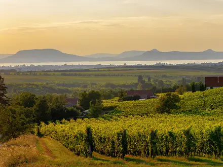
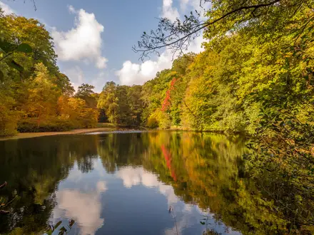
Tihany Peninsula Loop: Lake Balaton crater lakes and geyser cones
HikeList Score
Tihany Peninsula Loop scored 87/100 on HikeList's trail-quality metrics.
See score breakdownHide breakdown
- Ideal length 55
- Balanced challenge 100
- Scenery & wildness 98
- Varied terrain 94
- Accommodation 83
- Food & support 88
- Path quality 98
- Season flexibility 89
Computed from length, challenge, scenery & wildness, terrain variety, accommodation, food & support, path quality and season flexibility.
The Tihany Peninsula Loop is a moderate 16 km day hike on the northern shore of Lake Balaton in Veszprém County, Hungary. Starting and finishing in Tihany village, the circular route suits walkers who want a compact mix of volcanic geology, crater lakes, woodland, meadows and cultural landmarks without technical terrain. Allow a full day, roughly 4–6 hours with stops. Expect mostly easy paths and dirt tracks, with rockier, uneven ground around the geyser cones and Óvár cliffs.
Route Overview
Start in Tihany village, commonly near the Benedictine Abbey or Belső-tó, and follow the waymarked Hungarian colour-blaze paths around the peninsula before returning to the start. Either direction works; no single official direction is specified in the verified brief. A representative full circuit links the Abbey and Echo Hill, Belső-tó, the reedy Külső-tó nature reserve, the Aranyház geyser cone, Csúcs-hegy, the Óvár cliffs, Barátlakások hermit caves and the old lavender fields. Specific access transport is not verified here. For longer walking in the same protected landscape see the Balaton Uplands Trail, or compare another volcanic Lake Balaton hike on the Badacsony Volcano Trail.
Tihany’s abbey, charter and protected landscape
Tihany has been settled since prehistory, but its defining landmark is the Benedictine Abbey, founded in 1055 by King Andrew I. The abbey’s founding charter preserves the earliest written Hungarian words, making the site important well beyond the peninsula. In 1952, Tihany became Hungary’s first protected landscape area, recognising its post-volcanic landforms, crater lakes and distinctive flora. It is now part of the Balaton Uplands National Park.
Notable highlights
- Tihany Benedictine Abbey: Founded in 1055 by King Andrew I, the abbey dominates the village skyline. Its founding charter contains the oldest surviving written Hungarian words, and the crypt holds Andrew I’s tomb.
- Belső-tó (Inner Lake): A crater lake in the middle of the peninsula, sitting about 25 m higher than Lake Balaton. It is an easy scenic focus of the loop and is ringed by geyser cones to the south.
- Külső-tó (Outer Lake): A reedy crater lake and nature reserve on the peninsula. It adds a quieter wetland section to the walk.
- Geyser cones and Aranyház: Around 110 post-volcanic cone-shaped hills were formed by hot springs after volcanic activity ceased. Aranyház, the Golden House, is the best-known cone, named for yellow lichen on its rock.
- Barátlakások hermit caves: Cells, a chapel and a refectory were carved into the soft basalt tuff of Óvár hill by Greek Orthodox monks. The caves are one of the route’s most distinctive historic stops.
- Old lavender fields: Lavender was planted on Tihany’s sunny volcanic slopes in the 1920s by Gyula Bittera. From mid-June, the fields below Csúcs-hegy are a key seasonal draw.
Challenges to expect
The loop is moderate rather than strenuous, but do not expect a flat lakeside stroll. Forest paths, grassy tracks and meadows are mixed with rocky, uneven basalt-tuff sections around the geyser cones and Óvár cliffs, where sure footing helps. Navigation uses Hungarian colour-blaze waymarks rather than a single named 16 km official trail. In summer, the sunny near-Mediterranean microclimate can make exposed sections feel hot.
HikeList Score
Tihany Peninsula Loop scored 87/100 on HikeList's trail-quality metrics.
See score breakdownHide breakdown
- Ideal length 55
- Balanced challenge 100
- Scenery & wildness 98
- Varied terrain 94
- Accommodation 83
- Food & support 88
- Path quality 98
- Season flexibility 89
Computed from length, challenge, scenery & wildness, terrain variety, accommodation, food & support, path quality and season flexibility.
Show more data Show less
- Forest
- Meadows
- Volcanic
- Lakeside
- Dirt
- Grass
- Rocky
- Guesthouses
- Hotels
- Campsites
- Family Friendly
- Pet Friendly
- Restrooms
- Water Sources
- Campsites
- Picnic Areas
Download Our Full Guide to Tihany Peninsula Loop FREE!
Get our comprehensive guide to this hike for free. Save it for later reading or print out at home.
Photos from hikers
Taken on the trail by people who've reviewed Tihany Peninsula Loop.
Tihany Peninsula Loop: The Complete Guide
 i
Image by larairimeeva
i
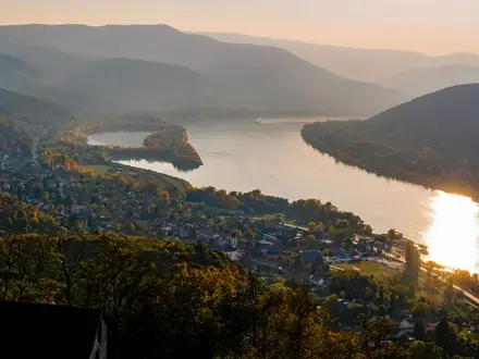
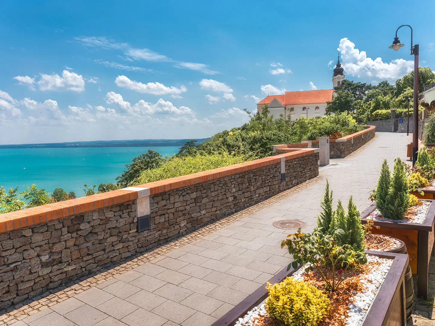
Image by larairimeeva The Tihany Peninsula Loop is a compact, rewarding day walk on Hungary’s Lake Balaton: a 15–16 km circuit from Tihany village through crater lakes, volcanic cone country, woodland and open viewpoints. It suits walkers who want a proper hike with culture and geology built in, without committing to a multi-day route.
The route can start near Tihanyi Bencés Apátság (Tihany Benedictine Abbey) or by Belső-tó (Inner Lake) at Levendula Ház (Lavender House). From there it works out across the inner peninsula towards Aranyház gejzírkúp and the Gejzír-mező, where post-volcanic hot-spring cones give the walk its most distinctive terrain.
The western half brings quieter paths through Szarkádi-erdő, the high point at Csúcs-hegy and the Őrtorony kilátó viewpoint. The return can take in Külső-tó, the Barátlakások hermit caves on Óvár and Visszhang-domb before dropping back into Tihany.
This is moderate rather than hard: expect around 270 m of ascent, short steeper pulls, uneven basalt-tuff underfoot and exposed sunny slopes. It is well covered by Hungarian colour-blaze waymarks, but there is no single official prescribed direction, so a map or reliable offline navigation is still sensible.
This guide covers route stages, timing, accommodation, food, transport, terrain and common mistakes.
Stage-by-Stage Guide
Stage 1: Tihany village to Tihany village via Belső-tó, Gejzír-mező, Csúcs-hegy, Külső-tó, Óvár and Visszhang-domb
This is a compact but varied full-day circuit of the Tihany peninsula, starting and finishing in Tihany village. Most walkers begin either near Tihanyi Bencés Apátság (Tihany Benedictine Abbey) in the old village or lower down by Belső-tó (Inner Lake), close to Levendula Ház (Lavender House).
Although the loop is only about 15–16 km, it is not a flat lakeside promenade. The route links village lanes, crater-lake paths, open meadows, woodland tracks and rougher basalt-tuff ground around the geyser cones and the Óvár cliffs, with short but noticeable climbs adding up to roughly 270 m of ascent.
Route character and landmarks
From Tihany village, the walk quickly reaches the abbey heights and the inner peninsula. Tihanyi Bencés Apátság is the main cultural landmark of the route: founded in 1055 by King Andrew I, it stands above Lake Balaton and contains the king’s tomb in the crypt.
The route then works around Belső-tó (Inner Lake), a crater lake sitting roughly 25 m higher than Lake Balaton. This is one of the easiest sections of the walk, with broad views across the water towards the volcanic slopes and cones to the south.
South and west of Belső-tó, the loop enters the Gejzír-mező (Geyser Meadow). The key feature here is Aranyház gejzírkúp (‘Golden House’ geyser cone), named for the yellow lichen on its rock. The surrounding meadow contains dozens of post-volcanic hot-spring cones, and this is one of the best sections for understanding why Tihany is much more than a lakeside resort.
The western half of the circuit rises towards Szarkádi-erdő (Szarkád woods), Csúcs-hegy and the Őrtorony kilátó (Watchtower lookout). Csúcs-hegy, at about 232 m, is the highest point of the peninsula rather than a major summit, but the views over Lake Balaton, the inner lakes and the geyser-cone country are among the best on the route.
The loop then turns back through the quieter wetland side of the peninsula around Külső-tó (Outer Lake), a reedy crater lake and nature reserve known for birdlife. From there, the route returns towards the village via Óvár, passing the Barátlakások (hermit caves), with the nearby Ciprián-forrás (Ciprián Spring), before reaching Visszhang-domb (Echo Hill) above Tihany.
Terrain and path conditions
Expect a mixture of firm dirt tracks, grassy paths, forest sections and rockier, uneven ground on the volcanic tuff. The roughest walking is around the geyser cones and the Óvár cliff area, where sure footing is useful, especially after rain.
The climbs are short rather than sustained, but several are steep enough to slow the pace. In dry weather the open slopes can feel hot and exposed, particularly in summer; in wet weather, the rocky and earthen sections can become slippery.
This is a moderate day walk, not a technical hike. Walking shoes or lightweight boots with good grip are more appropriate than smooth-soled trainers, especially if including the rockier cone and cliff sections.
Navigation notes
There is no single official dedicated “Tihany Peninsula Loop” trail with one fixed line. The circuit is assembled from the peninsula’s Hungarian colour-blaze paths, including blue, yellow and green stripe, cross and triangle markings, and the exact distance varies depending on which links are chosen.
The best-known named circuit, the Helka Kör, is about 15 km, while other waymarked variants are shorter. For the full HikeList-style loop including the abbey, Belső-tó, Aranyház, Csúcs-hegy, Őrtorony kilátó, Külső-tó, Barátlakások and Visszhang-domb, allow for about 16 km.
Carry an offline map or GPX track as well as following the blazes. Waymarking is generally the basis of navigation here, but the peninsula has many intersecting paths, and it is easy to shorten, extend or accidentally alter the circuit.
There is no required direction. Starting from the abbey gives an immediate cultural and viewpoint section; starting from Belső-tó / Levendula Ház puts the crater lake and geyser meadow closer to the beginning of the day.
Food, water and facilities
Tihany village is the practical place for food, drinks and facilities before and after the walk. Once away from the village, the route spends long stretches in woods, meadows and protected countryside, so carry enough water and snacks for the whole circuit.
Do not rely on Ciprián-forrás as a drinking-water source unless local signage clearly indicates that the water is suitable. In summer, carry more water than the distance alone suggests, as the sunny slopes around the peninsula can be hot.
Accommodation at the end
Because this is a circular day hike, accommodation is normally taken in Tihany village or in the wider northern-shore resort area around Balatonfüred. Options include guesthouses, hotels and campsites.
July and August are the busiest Balaton season, and accommodation in and around Tihany should be booked ahead. Prices and availability vary sharply by season, so current rates should be checked before booking.
Public transport and road access
Tihany has no railway station. The usual public-transport approach is by MÁV train to Balatonfüred, then a local Volánbusz/MÁV bus to Tihany, taking about 15 minutes for the bus leg.
In the warm season, the Tihany-rév car and passenger ferry links the peninsula with Szántód-rév on the south shore of Lake Balaton. BAHART passenger boats also connect Tihany with other Balaton ports seasonally.
Bus, ferry and boat times should be checked before travelling, especially outside the main summer period. Drivers can use parking in Tihany village or around Belső-tó / Levendula Ház, but local parking rules and charges should be checked on arrival.
Warnings and seasonal considerations
The main practical hazards are heat, exposure and slippery footing rather than remoteness or technical difficulty. Summer walkers should start early, carry sun protection and avoid underestimating the open volcanic slopes.
After rain, take care on the basalt-tuff and earthen paths around Aranyház gejzírkúp, Gejzír-mező and the Óvár cliffs. These sections are short, but a slip here is more likely than on the easier lake and meadow tracks.
Külső-tó is a nature reserve area, and parts of the geyser-cone and cliff landscape are sensitive protected terrain within Balaton Uplands National Park. Stay on marked paths, follow local signage and check for any temporary restrictions before relying on a specific path line.
Lavender usually flowers from about mid-June into early July, when the slopes below Csúcs-hegy are especially popular. This is also a busier period on the peninsula, so allow extra time for travel, parking and post-walk services.
Recommended Itinerary
Standard itinerary: full Tihany peninsula circuit
This is the best fit for most walkers: one complete day loop from Tihany village, taking in the crater lakes, geyser-cone country, Csúcs-hegy, the Őrtorony kilátó (Watchtower lookout), the Barátlakások (hermit caves) and Visszhang-domb (Echo Hill) before returning to the village.
| Day | From | To | Approx. distance | Why this stage makes sense | Services/accommodation notes |
|---|---|---|---|---|---|
| 1 | Tihany village, usually near Tihanyi Bencés Apátság (Tihany Benedictine Abbey) or Belső-tó (Inner Lake) / Levendula Ház (Lavender House) | Tihany village, via Belső-tó, Aranyház gejzírkúp, Gejzír-mező, Szarkádi-erdő, Csúcs-hegy, Őrtorony kilátó, Külső-tó, Barátlakások, Visszhang-domb | About 15–16 km | A single-day loop suits the peninsula well: the total ascent is moderate, the high point at Csúcs-hegy is only about 232 m, and the route naturally returns to the main village services. It gives enough time for the rocky geyser-cone sections, viewpoints and historic stops without needing a mid-route overnight. | Stay in Tihany or nearby Balatonfüred before/after the walk. Tihany has guesthouses, hotels and campsites in and around the village; Balatonfüred gives a wider northern-shore base. Book ahead in July–August. Do not rely on regular services away from Tihany village unless checked locally; carry water and food for the circuit. |
Slower variant: relaxed sightseeing day or shorter marked circuit
This suits families, hot summer days, walkers using public transport, or anyone wanting time at the abbey, the crater lakes and the viewpoints rather than treating the walk as a continuous hike.
| Day | From | To | Approx. distance | Why this stage makes sense | Services/accommodation notes |
|---|---|---|---|---|---|
| 1 | Tihany village / Belső-tó | Tihany village, using a shorter waymarked peninsula circuit or a shortened version of the main loop | About 10–13 km for shorter marked circuits; check official mapping before booking | Tihany’s path network allows shorter loops than the full 15–16 km circuit. This is the better choice in strong heat, with children, or if the aim is to linger at Belső-tó, Gejzír-mező, the abbey area and Visszhang-domb rather than cover the full western peninsula. | Base in Tihany for the easiest start and finish. If staying in Balatonfüred, check current bus times to and from Tihany before travelling, especially outside the main visitor season. |
Faster variant: brisk Helka Kör-style day loop
This suits fitter walkers who are comfortable navigating Hungarian colour-blaze waymarks and moving efficiently over uneven basalt-tuff and woodland sections.
| Day | From | To | Approx. distance | Why this stage makes sense | Services/accommodation notes |
|---|---|---|---|---|---|
| 1 | Tihany village / Belső-tó | Tihany village, following the well-known Helka Kör-style peninsula loop | About 15 km | The Helka Kör is the best-known named circuit on the peninsula and is signed at roughly 6 hours at a comfortable pace. Strong walkers can treat it as a brisk day walk, but the rocky cone and Óvár cliff sections still require care, especially when wet. | A faster round is easiest with an early start from Tihany itself. If arriving from Balatonfüred, allow for the local bus connection; seasonal ferry and BAHART boat options should be checked before travelling. |
Planning the Route
How much time to allow
Plan the Tihany Peninsula Loop as a single-day walk. Most walkers should allow a full half-day to a relaxed day rather than treating it as a quick lakeside stroll, because the route is at its best with time for the abbey area, Belső-tó (Inner Lake), the geyser cones, viewpoints and Barátlakások (hermit caves).
A steady walker can complete the loop in one outing, but the better plan is to start early enough to avoid rushing the rockier and more exposed sections. In summer, an early start also helps with heat on the sunny slopes and open ground.
There is no need to split the route into overnight stages. The loop starts and finishes in Tihany village, and accommodation planning is about choosing a base before and after the walk, not arranging a hut-to-hut itinerary.
Choosing a start point and direction
Walkers commonly start either near Tihanyi Bencés Apátság (Tihany Benedictine Abbey) in Tihany Ófalu, or by Belső-tó near Levendula Ház (Lavender House). Both work well for a circular walk, so the best choice usually depends on where you are staying, arriving by bus, or parking.
There is no single official prescribed direction. A practical circuit links Tihany village with Belső-tó, Aranyház gejzírkúp (the ‘Golden House’ geyser cone), Gejzír-mező (Geyser Meadow), Csúcs-hegy, Őrtorony kilátó (Watchtower lookout), Külső-tó (Outer Lake), Barátlakások on Óvár, Visszhang-domb (Echo Hill), then back to the village.
Because the route is assembled from Hungarian colour-blaze paths rather than one dedicated trail, pay attention at junctions. Expect kék (blue), sárga (yellow) and zöld (green) stripe, cross and triangle blazes rather than one continuous branded waymark.
Shortening, extending and route variants
The full HikeList circuit is about 16 km, while the well-known Helka Kör is around 15 km. Shorter waymarked circuits on the peninsula run roughly 10–13 km, so it is easy to choose a smaller loop if heat, time or group pace becomes an issue.
The simplest way to shorten the day is to plan a circuit that focuses on Belső-tó, the geyser-cone area and nearby viewpoints, rather than trying to include every outer feature. Exact cut-offs depend on the waymarked junctions used on the day, so carry a current map or GPX rather than relying only on a written description.
Extensions are usually small additions around the village, abbey area, Visszhang-domb or lakeside approaches rather than a separate long-distance continuation. Adding the abbey and Echo Hill makes sense for walkers starting near Belső-tó, but it also adds time for sightseeing and village streets.
Section hiking practicality
This is not a route that needs section hiking in the long-distance sense. It is compact, circular and designed for a single outing.
For families, casual walkers or anyone wanting a shorter day, the peninsula is better treated as a set of smaller local walks from Tihany rather than as staged sections. Staying in Tihany or nearby Balatonfüred makes it practical to walk one part of the peninsula on one day and another on a separate day.
What matters most when planning
| Planning item | Practical guidance |
|---|---|
| Accommodation | Book a base in Tihany or the wider Balatonfüred / northern-shore area. July and August are peak Balaton season, so accommodation in Tihany is best booked ahead. |
| Transport | There is no railway or long-distance bus directly onto the peninsula. The usual public-transport approach is MÁV train to Balatonfüred, then a local Volánbusz/MÁV bus to Tihany. Seasonal ferry and BAHART boat options can be useful, but timetables should be checked before travelling. |
| Navigation | Do not expect one continuous official “Tihany Peninsula Loop” trail. Use the colour-blaze network, a map or GPX, and check junctions carefully around the geyser cones, woods and return towards the village. |
| Food and water | Carry enough water and snacks for the full loop once away from Tihany village. The route crosses woodland, meadows, crater-lake margins and rocky sections where mid-walk services should not be assumed. |
| Weather | Spring and autumn are the easiest seasons for comfortable walking. In summer, exposed slopes can be hot; after rain, basalt-tuff and rocky cliff sections can be slippery. |
| Access restrictions | The peninsula lies within Balaton Uplands National Park, with sensitive areas around Külső-tó, the geyser cones and Óvár cliffs. Stay on marked paths and check any current reserve or path restrictions before relying on a particular variant. |
| Money | Hungary uses the forint, HUF/Ft. Any parking, ferry, boat, food or admission costs should be budgeted in HUF and current prices checked before booking or travelling. |
Permits and protected areas
No special hiking permit is part of the standard planning for this day walk. The more important issue is responsible route choice within the Balaton Uplands National Park.
Keep to marked paths, especially around Külső-tó, Gejzír-mező and the Óvár cliff and cave area. Local path closures or reserve restrictions can change, so this should be checked before travelling if a particular viewpoint, nature-reserve path or geyser-cone section is essential to the day.
Towns, Villages and Overnight Stops
The Tihany Peninsula Loop is a day walk, not a multi-day trail, so there are no logical overnight stops between the start and finish. Most walkers either stay in Tihany itself or use Balatonfüred as the larger nearby base, then travel to Tihany for the walk.
Accommodation and transport are seasonal around Lake Balaton, especially in July and August. Book ahead in the summer peak, and check current bus, ferry and boat timetables before travelling.
Tihany Ófalu / Tihany village
Tihany village is the main start and finish point for the loop. Walkers commonly begin near Tihanyi Bencés Apátság (Tihany Benedictine Abbey) or from the Belső-tó (Inner Lake) side by Levendula Ház (Lavender House).
This is the best overnight stop for the route. Accommodation in and around Tihany includes guesthouses, hotels and campsites, with the widest pressure on beds during the July–August Balaton peak season and around the lavender-flowering period from about mid-June into early July.
Tihany is also the sensible place to sort food, water and any last-minute supplies before starting. Opening hours can be seasonal, so do not assume every café, shop or visitor facility will be open early, late or outside the main holiday months; this should be checked before travelling.
For transport, there is no railway station on the peninsula. The usual public-transport approach is by train to Balatonfüred, then a local Volánbusz/MÁV bus to Tihany, taking about 15 minutes. Buses also serve Tihany along the northern shore, and in the warm season boats and the Tihany-rév ferry can be useful depending on where you are staying around Lake Balaton.
By car, parking is available in Tihany village and by Belső-tó / Levendula Ház. Parking arrangements, charges and busy-period availability should be checked locally, and payment should be expected in Hungarian forint (HUF / Ft), not euros.
Tihany is worth allowing time for either before or after the walk. The abbey is one of the peninsula’s key historic sites, and Visszhang-domb (Echo Hill) sits close enough to the village to make it a natural final or early stop on the loop.
Belső-tó and Levendula Ház
Belső-tó (Inner Lake) is not a separate village, but it is one of the most practical starting points on the route. It sits close to the centre of the peninsula and near Levendula Ház, with parking noted in the route information for this area.
This area works well if the priority is an easy start onto the loop rather than beginning in the tighter old-village streets by the abbey. It also places walkers quickly onto the crater-lake and geyser-cone side of the circuit.
There is no reason to treat Belső-tó as an overnight stop separate from Tihany. Stay in Tihany village or the wider Balatonfüred / northern-shore area, then walk or travel to the chosen start point.
Food and water should be organised before committing to the full circuit. Facilities around visitor centres and tourist areas can be seasonal, so current opening hours should be checked before relying on them.
Gejzír-mező, Szarkádi-erdő and Csúcs-hegy
The middle and western part of the loop passes through Gejzír-mező (Geyser Meadow), Szarkádi-erdő (Szarkád woods) and up towards Csúcs-hegy, the high point of the peninsula at about 232 m. These are walking sections, not service stops.
There is no accommodation, transport hub or dependable resupply point to plan around here. Carry enough water, food and sun protection from Tihany, particularly in summer when the open volcanic slopes can feel hot.
This part of the route is the main reason to avoid treating the walk as a casual village stroll. The ground includes uneven basalt-tuff sections around the geyser cones, dirt tracks, woodland paths and short steeper climbs, so footwear and water matter even though the overall circuit is compact.
Őrtorony kilátó and Külső-tó
Őrtorony kilátó (Watchtower lookout) and Külső-tó (Outer Lake) are important route points on the quieter inland side of the peninsula. They are scenic and navigationally useful, but they are not overnight bases.
Külső-tó is a reedy crater lake and nature-reserve area, so walkers should stay on permitted paths and avoid treating the lakeside as a picnic-or-wandering zone without checking local restrictions. Any current reserve or path restrictions should be checked before travelling.
Do not plan on food, shops or public transport at these points. They are places to pause during the walk, not places to solve logistics.
Barátlakások, Óvár and Visszhang-domb
The Barátlakások (hermit caves) on Óvár and Visszhang-domb (Echo Hill) sit on the return side of the loop towards Tihany village. They are close enough to the settlement to be combined with either the start or finish, depending on the direction chosen.
These are historic and viewpoint stops rather than overnight locations. Accommodation and food planning still belongs in Tihany village or a nearby Balaton base.
The Óvár cliff and cave area includes uneven ground, and the path can be slippery when wet. If any access restrictions are in place around the caves, cliffs or nearby Ciprián-forrás (Ciprián Spring), follow the local signage.
Balatonfüred
Balatonfüred is the most useful nearby base if Tihany accommodation is full, expensive or inconvenient. It sits off the loop, but it is the main rail gateway for many walkers approaching the peninsula by public transport.
The standard public-transport plan is to take a MÁV train to Balatonfüred, then continue by local Volánbusz/MÁV bus to Tihany. The bus journey is about 15 minutes, but current timetables should be checked before travelling, especially for early starts, late returns and out-of-season trips.
As a larger northern-shore resort area, Balatonfüred generally offers a broader accommodation base than the peninsula itself. It is a practical choice for walkers who want more flexibility, though staying there adds a short transfer at the start and end of the hiking day.
Tihany-rév and Szántód-rév
Tihany-rév is relevant for access rather than for the walking route itself. In the warm season, the car and passenger ferry crosses Lake Balaton between Tihany-rév and Szántód-rév, which can be useful if approaching from the southern shore.
This should not be treated as a guaranteed year-round link without checking the seasonal timetable. BAHART passenger boats also link Tihany with other Balaton ports in season, but sailing dates and times vary.
Ferry, boat, parking and local transport payments should be planned in Hungarian forint (HUF / Ft). Hungary has not adopted the euro as legal tender.
Getting to the Start
The Tihany Peninsula Loop starts and finishes in Tihany village, usually near Tihanyi Bencés Apátság (Tihany Benedictine Abbey) or by Belső-tó (Inner Lake) at Levendula Ház (Lavender House). Because it is a circular day walk, the simplest plan is to arrive in Tihany, walk the loop, and return to the same transport stop or car park.
By train
There is no railway station on the Tihany peninsula. The usual rail approach is by MÁV train to Balatonfüred, then by local bus on to Tihany.
The Balatonfüred–Tihany bus leg is short, about 15 minutes, but the exact service pattern varies by day and season. Train and bus connections should be checked together before travelling, especially if planning to complete the loop as a day trip rather than staying locally.
From the bus stop in Tihany, allow time to reach the chosen starting point near the Abbey or Belső-tó. Do not assume the first stop in the village is the most convenient for the route variant being walked; this should be checked before travelling.
By bus
Local Volánbusz/MÁV buses run from Balatonfüred to Tihany, and buses also serve Tihany along the northern shore of Lake Balaton. No railway or long-distance bus reaches the peninsula directly, so most public-transport journeys involve a change at Balatonfüred or elsewhere on the northern shore.
For the most straightforward start, aim for a Tihany village stop convenient for Tihanyi Bencés Apátság or Levendula Ház by Belső-tó. Current bus times, stop locations and return services should be checked before travelling, particularly outside the main summer season or late in the day.
In the warm season, additional access is possible via the Tihany-rév car/passenger ferry from Szántód-rév and by BAHART passenger boats linking Tihany with other Balaton ports. Ferry and boat services are seasonal, so timetables should be checked before relying on them.
By car
Driving is the most flexible option for an early start or for walking outside the busiest public-transport hours. Parking is available in Tihany village and around Belső-tó / Levendula Ház, both of which work well because the route is a loop.
Tihany is a popular Balaton destination, and parking can be busy in the July–August peak season and during lavender flowering around mid-June to early July. Arrive early if starting from the Abbey area or Belső-tó, and check current parking rules and HUF charges before leaving the car.
From the nearest airport
Airport access is not the key final-stage issue for this hike; the practical trailhead connection is getting to Balatonfüred and then on to Tihany by local bus, taxi or seasonal boat/ferry options where suitable. The best airport, onward rail route and late-arrival feasibility depend on current flight and public-transport timetables. This should be checked before travelling.
If arriving late, staying in Balatonfüred or Tihany the night before is usually simpler than trying to combine a same-day flight, transfer and 15–16 km walk.
Where to stay before starting
Most walkers stay in Tihany village or nearby Balatonfüred before the walk. Tihany is the most convenient base for an early start from the Abbey or Belső-tó, while Balatonfüred gives more onward transport flexibility and an easy bus connection to the peninsula.
Accommodation around Tihany and the northern shore includes guesthouses (panziók), hotels and campsites. July and August are the busiest months around Lake Balaton, so accommodation should be booked ahead in peak season, and all prices should be checked in HUF before booking.
Getting Home from the Finish
The route finishes back in Tihany village, normally near the Tihanyi Bencés Apátság (Tihany Benedictine Abbey) or the Belső-tó (Inner Lake) / Levendula Ház (Lavender House) area. That makes exit logistics straightforward: you return to the same transport options used for arrival, with no separate end-point transfer needed.
By train
Tihany has no railway station. The practical railhead is Balatonfüred, reached from Tihany by local Volánbusz / MÁV bus in around 15 minutes, then onward by MÁV train.
If relying on a train connection after the walk, check the final bus from Tihany to Balatonfüred before setting out. The loop is only a day walk, but stops at the abbey, Belső-tó, the geyser cones, Őrtorony kilátó and Barátlakások can easily stretch the day, especially in summer heat.
For late finishes, do not assume there will be a convenient bus-to-train connection from Tihany. Either finish with a generous time margin, pre-arrange a taxi to Balatonfüred, or stay in Tihany overnight.
By bus
Local buses link Tihany with Balatonfüred, and buses also serve Tihany along the northern shore of Lake Balaton. There is no direct railway or long-distance bus on the peninsula itself, so Balatonfüred is the key public-transport connection for most onward journeys.
Timetables are seasonal and should be checked before travelling, particularly outside the main Balaton holiday period and for evening departures. Allow extra time to walk from the route finish to the correct village stop, especially if ending near Belső-tó rather than directly in the old village.
In the warm season, there are also lake transport options: the Tihany-rév car/passenger ferry crosses to Szántód-rév, and BAHART passenger boats link Tihany with other Balaton ports. These are useful for continuing around Lake Balaton, but their operating seasons and daily timetables vary, so they should be checked before relying on them.
By car/taxi
Because this is a loop, drivers finish where they started. Parking is available in Tihany village and around the Belső-tó / Levendula Ház area, making a car-based day walk simple provided a suitable legal space is available.
Parking demand can be high in the July-August Balaton peak season and during the lavender period from about mid-June into early July. Arriving early is the safer plan, and any parking charges should be paid in Hungarian forint (HUF); current parking rules and prices should be checked locally.
Taxis are the sensible fallback if the final bus to Balatonfüred has gone. Do not rely on finding an immediate taxi at the trail finish late in the day; pre-book from Tihany or Balatonfüred if a train connection, hotel check-in or onward journey depends on it.
If leaving by car towards the southern shore, the seasonal Tihany-rév to Szántód-rév ferry can be convenient. Ferry times and fares change by season and should be checked before travelling.
From the nearest airport
There is no airport on the Tihany peninsula, and airport access is not part of the local trail transport network. If flying, plan the journey in two steps: reach Balatonfüred by national transport or transfer, then use the local bus or taxi connection to Tihany.
Airport-to-Balaton connections are timetable-dependent and should be checked before booking fixed onward travel. For a same-day flight after the hike, build in a large buffer or stay overnight in Tihany or Balatonfüred and travel the next day.
Where to stay at the finish
Staying at the finish is often the simplest option because the loop ends in Tihany village. There are guesthouses, hotels and campsites in and around Tihany, with further accommodation in Balatonfüred and the wider northern-shore resort area.
Book ahead in July and August, and also around the lavender flowering period from mid-June into early July. If public transport connections look thin or the walk is being combined with abbey visits, viewpoints and longer breaks, an overnight stay in Tihany removes the pressure of catching the last bus off the peninsula.
Which Direction Should You Walk?
There is no single official prescribed direction for the Tihany Peninsula Loop. The route is a circular walk assembled from Hungarian colour-blaze paths, so either direction works and transport logistics are identical: you start and finish in Tihany village, usually near Tihanyi Bencés Apátság (Tihany Benedictine Abbey) or Belső-tó (Inner Lake) by Levendula Ház (Lavender House).
Recommended direction: Belső-tó, geyser cones, Csúcs-hegy, Külső-tó, Óvár, Tihany
The most practical direction is to leave Tihany village for Belső-tó, continue towards Aranyház gejzírkúp and Gejzír-mező, then cross the western half of the peninsula via Csúcs-hegy and Őrtorony kilátó before returning by Külső-tó, Barátlakások on Óvár and Visszhang-domb.
This gives the walk a good scenic progression. The first part gets you quickly onto open volcanic ground and the geyser-cone country, then the middle of the day reaches the higher viewpoints around Csúcs-hegy and Őrtorony kilátó. The return through Külső-tó, the hermit caves and Echo Hill brings in the quieter wetland and historic sections before dropping back into Tihany.
It is also a good choice in warm weather. The sunnier, more exposed slopes around the geyser cones and western hills are best tackled before the heat builds too much, especially in June, July and August. An early start matters more than direction, but this order puts several open sections earlier in the walk.
Walking it in reverse
The reverse direction is perfectly workable. Starting with Visszhang-domb, Óvár and Barátlakások gives an immediate historic focus, then the route moves on towards Külső-tó and the western viewpoints before returning through the geyser-cone country and Belső-tó.
The main drawback is timing on hot days. In reverse, the exposed volcanic slopes around Gejzír-mező and Aranyház gejzírkúp may come later, when the sun is stronger. If walking in spring or autumn this is much less important.
The climbs are not different enough to make one direction clearly easier. The loop has short, moderately steep rises and uneven basalt-tuff sections whichever way it is walked, with the high point at Csúcs-hegy around 232 m. Sure footing matters more than direction, particularly after rain when rocky or polished sections can be slippery.
Transport, accommodation and finish
Because this is a one-day loop, direction has no real effect on transport or accommodation planning. Buses, parking and seasonal boat or ferry connections all bring walkers back to the same Tihany start area, and most overnight stays are in Tihany, Balatonfüred or elsewhere along the northern shore.
The recommended direction has the better psychological finish. Returning via Barátlakások, Visszhang-domb and the abbey side of Tihany gives a strong final hour, with historic stops and village facilities close together at the end of the walk.
Recommendation: walk the loop from Tihany via Belső-tó, Aranyház gejzírkúp, Gejzír-mező, Csúcs-hegy, Őrtorony kilátó, Külső-tó, Barátlakások and Visszhang-domb back to Tihany. Reverse it only if weather, waymarking on the day or a shorter local variation makes that more convenient.
Accommodation Along the Route
The Tihany Peninsula Loop is a day walk, so accommodation planning is about choosing a good base rather than finding overnight stops between stages. There is no practical need to sleep mid-route: the circuit starts and finishes in Tihany village, and the interior of the peninsula is largely woodland, meadow, crater-lake and protected landscape rather than a chain of villages.
Most walkers stay either in Tihany itself or in the wider Balatonfüred / northern-shore resort area. Tihany is the most convenient base for an early start from the Tihanyi Bencés Apátság (Tihany Benedictine Abbey) or Belső-tó (Inner Lake), while Balatonfüred usually gives a broader resort-town base with onward transport to the peninsula.
| Place | Accommodation level | Best for | Notes |
|---|---|---|---|
| Tihany village / Ófalu | Good | Easiest overnight base for the loop | Guesthouses, hotels and campsites are available in and around Tihany. Best choice if starting near the Abbey, Belső-tó or Levendula Ház (Lavender House). Book well ahead in the July–August Balaton peak season. |
| Belső-tó / Levendula Ház area | Limited | Starting close to the trailhead | Useful as a start/finish area, but treat it as part of the wider Tihany accommodation search rather than a separate overnight stop. Parking and visitor facilities make it a practical meeting point. |
| Interior of the loop: Aranyház gejzírkúp, Gejzír-mező, Szarkádi-erdő, Csúcs-hegy, Külső-tó and Óvár | None | Day-walking only | Do not plan on overnight accommodation on the route itself. Carry what is needed for the day and return to Tihany. |
| Balatonfüred / northern shore of Lake Balaton | Good | More choice and a resort-town base | A practical alternative if Tihany is full or expensive. Access is normally by train to Balatonfüred, then local bus to Tihany; current bus times should be checked before travelling. |
Booking strategy
For the simplest logistics, stay in Tihany the night before the walk. This avoids depending on the morning bus from Balatonfüred and makes it easier to start early before the hottest part of a summer day.
Accommodation pressure is highest in July and August, when Lake Balaton is at its busiest. Weekends can also be tight, and the lavender flowering period from about mid-June into early July brings extra demand around Tihany. Advance booking is strongly recommended for these periods.
Spring and autumn are usually easier for accommodation planning, though weekend demand can still be noticeable in good weather. Opening periods for some seasonal campsites and tourist accommodation can vary, so availability should be checked before relying on a particular type of stay.
Guesthouses, hotels and campsites
Tihany and the surrounding Balaton resort area offer a mix of panziók, hotels and campsites. A guesthouse in Tihany is usually the most practical choice for walkers who want to step straight onto the loop without extra transport.
Campsites can work well in warm weather, especially for budget-conscious walkers, but they should not be assumed to sit directly on the walking line. Check location carefully against the intended start point at the Abbey or Belső-tó, and confirm opening dates before booking.
Accommodation prices are paid in Hungarian forint (HUF / Ft). Rates vary sharply by season and location around Lake Balaton, so current prices should be confirmed before booking.
Transfers, taxis and luggage
Luggage transfer is not a meaningful requirement on this route. The walk is a single-day circuit returning to the same village, so bags can be left at accommodation where permitted.
Taxi or local transfer arrangements may help if staying outside Tihany, especially for an early start or after an evening meal in the village, but this is a convenience rather than a route necessity. If relying on a taxi, arrange it in advance or check local availability before travelling.
For most walkers based in Balatonfüred, the usual approach is public transport to Tihany and back. Current bus timetables should be checked seasonally, particularly if planning a late finish.
Camping and Wild Camping
Does this route suit camping?
The Tihany Peninsula Loop is a day walk of about 15–16 km, starting and finishing in Tihany village. It does not need a camping itinerary, and most walkers are better off using a guesthouse, hotel or campsite in Tihany or nearby Balatonfüred, then walking the loop with a light day pack.
Camping only makes practical sense if Tihany is part of a longer Balaton trip. For this loop alone, carrying overnight gear adds little benefit: there is no stage break, no remote overnight objective, and the route repeatedly passes protected, popular or sensitive areas.
Campsites near the route
There are campsites in and around Tihany village and in the wider Balatonfüred / northern-shore resort area. These are the sensible camping bases for the walk, rather than trying to sleep somewhere on the peninsula circuit itself.
| Base | Practical use for the loop |
|---|---|
| Tihany village / peninsula area | Best for starting early near the Tihanyi Bencés Apátság (Tihany Benedictine Abbey) or Belső-tó (Inner Lake). Useful if walking without a car. |
| Balatonfüred / northern shore | A broader accommodation base with onward bus access to Tihany. Bus times should be checked before travelling. |
July and August are the busiest Balaton months, so campsites and other accommodation should be booked ahead where possible. Current opening dates, pitch availability and prices in HUF should be confirmed before booking.
Wild camping and protected areas
The peninsula lies within the Balaton Uplands National Park, and Tihany was Hungary’s first protected landscape area. The route also passes sensitive places such as Külső-tó (Outer Lake), the Gejzír-mező (Geyser Meadow), the geyser cones, Óvár and the Barátlakások (hermit caves).
Wild camping should not be planned anywhere along the loop unless local permission and current national park rules clearly allow it. This should be checked before travelling. In practice, the route is compact, well visited and environmentally sensitive, so a formal campsite is the responsible option.
Avoid camping or bivvying around Belső-tó, Külső-tó, the Aranyház gejzírkúp (‘Golden House’ geyser cone), the Óvár cliff paths, viewpoints such as Őrtorony kilátó (Watchtower lookout), and historic sites such as the Barátlakások. These are places to pass through carefully, not overnight stops.
Water and cooking
Do not rely on natural water along the loop. Belső-tó and Külső-tó are lakes rather than practical drinking-water sources, and Külső-tó is a reedy nature reserve area. Ciprián-forrás (Ciprián Spring) is marked near the Barátlakások area, but potability should not be assumed.
Carry enough water from Tihany or from your campsite/accommodation, especially in summer when the exposed volcanic slopes can feel hot. If camping at an official site, cook there rather than on the trail.
Open fires should not be used on the route unless a place is clearly designated for that purpose and current fire rules allow it. Seasonal fire restrictions can change in dry weather; this should be checked before travelling.
Low-impact practice
Keep to waymarked paths through the protected sections, especially around the geyser cones, Óvár cliffs and Külső-tó. Do not cut across lavender slopes, meadows or closed reserve areas to look for a camping spot.
Pack out all litter, food waste and toilet paper. If using an official campsite, use its toilets and washing facilities before starting the loop. Noise and lights should be kept low around the lakes, woodland edges and birdlife areas, particularly near Külső-tó.
Food, Water and Resupply
This is a short day walk, not a resupply-based trail. The practical approach is simple: start with a full day’s food and water from Tihany village or from your accommodation, then treat anything available on the way as a bonus rather than a plan.
Food and drink are easiest before and after the walk in Tihany village, especially around the old village, the Tihanyi Bencés Apátság (Tihany Benedictine Abbey) and the Belső-tó (Inner Lake) area. Once the route leaves the village for the Gejzír-mező (Geyser Meadow), Csúcs-hegy, Őrtorony kilátó (Watchtower lookout), Külső-tó (Outer Lake) and Óvár, there should be no assumption of shops, cafés, supermarkets or petrol-station resupply on the trail itself.
Seasonal opening hours matter around Lake Balaton. Summer brings the widest choice, while outside the main visitor season some cafés, kiosks and food stops may have reduced hours or close entirely; Sunday and public-holiday opening can also be limited. This should be checked before travelling, especially if starting early or walking outside July and August.
How much to carry
For the full 15–16 km loop, carry lunch or substantial snacks even if planning to eat in Tihany afterwards. The walk is only 4–6 hours for most walkers, but the middle of the circuit crosses woodland, open slopes and nature-reserve terrain where resupply should not be expected.
Water needs are higher than the distance suggests in summer. The peninsula has sunny, exposed slopes, and the basalt-tuff sections around the geyser cones and Óvár can feel hot in still weather. As a practical minimum, most walkers should leave Tihany with enough water for the full circuit; in hot weather, carry more than would normally be needed for a half-day walk.
Water sources on the route
Fill bottles before leaving Tihany village, at your accommodation or at a food stop where drinking-water refills are available. Do not rely on Belső-tó, Külső-tó or Lake Balaton as drinking-water sources.
Ciprián-forrás (Ciprián Spring) is near the Barátlakások (hermit caves) area on Óvár, but any spring or natural source should only be used if it is clearly signed as drinkable, or after suitable treatment. Filtering or purifying is sensible if using natural water in an emergency, and wetland or lake water is best avoided altogether.
| Section | Food availability | Water availability | Notes |
|---|---|---|---|
| Tihany village / Abbey / Belső-tó start | Best place to eat or buy food before setting off. Exact cafés, shops and opening times vary by season. | Best place to fill bottles before the walk. | Start with the day’s food and water here rather than depending on the outer loop. Use HUF for purchases. |
| Belső-tó to Aranyház gejzírkúp and Gejzír-mező | No dependable on-trail food resupply. | No dependable drinking-water refill. | Carry snacks and water from Tihany; exposed sections can be hot in summer. |
| Gejzír-mező / Szarkádi-erdő / Csúcs-hegy / Őrtorony kilátó | No dependable food resupply. | No dependable drinking-water refill. | This is the section where self-sufficiency matters most, despite the short overall distance. |
| Külső-tó nature-reserve area | No dependable food resupply. | Do not treat the reedy lake or wetland water as a drinking source. | Keep to permitted paths and avoid disturbing reserve areas. Any current restrictions should be checked before travelling. |
| Óvár / Barátlakások / Visszhang-domb back to Tihany | No guaranteed food until returning to the village. | Ciprián-forrás is near the Barátlakások area, but drink only if clearly potable or after treatment. | The route is close to Tihany again, but carry enough to finish without needing a refill. |
| Tihany village finish | Best place for a meal or drink after the walk. | Refill or buy drinks after the walk. | Peak-season choice is better; off-season and Sunday hours should be checked in advance. |
Terrain, Conditions and Difficulty in Practice
The Tihany Peninsula Loop is moderate because of its varied surfaces rather than its altitude. The standard full circuit is about 15–16 km with roughly 270 m of ascent, so the effort is manageable for most regular walkers, but it is not a flat promenade around Lake Balaton.
Most of the route uses woodland paths, grassy tracks, dirt tracks and open meadow paths across the volcanic peninsula. The rougher parts come around the Aranyház gejzírkúp (‘Golden House’ geyser cone), the wider Gejzír-mező (Geyser Meadow), the slopes around Csúcs-hegy, and the Óvár cliff area near the Barátlakások (hermit caves), where basalt-tuff rock makes the going more uneven underfoot.
Surfaces underfoot
| Part of the loop | Typical terrain | What to watch for |
|---|---|---|
| Tihany village, Tihanyi Bencés Apátság and Belső-tó | Easy village access, lakeside and track-style walking | Straightforward, but often busier around the main sights |
| Belső-tó to Aranyház gejzírkúp and Gejzír-mező | Grassy paths, dirt tracks and volcanic cone terrain | Uneven basalt-tuff sections; rock can be slippery when wet |
| Szarkádi-erdő, Csúcs-hegy and Őrtorony kilátó | Woodland paths, slopes and viewpoint approaches | Shorter climbs and descents; exposed sections can feel hot |
| Külső-tó area | Quieter crater-lake and nature-reserve terrain | Stay to marked paths and check any current reserve restrictions before travelling |
| Óvár, Barátlakások and Visszhang-domb | Cliffside / hillside paths with historic rock-cut features | Sure footing is useful on rougher, worn or rocky sections |
There is no technical scrambling on the normal loop, and hands should not be needed for progress in ordinary conditions. The practical difficulty is more about foot placement, heat management and following the correct colour-blaze junctions than about steep mountain terrain.
Climbs, descents and exposure
The route’s highest point is Csúcs-hegy at about 232 m, so the height gain is modest. However, the peninsula rises and falls repeatedly between crater lakes, ridges, woods, geyser-cone country and viewpoints, creating several short climbs rather than one major ascent.
The steeper sections are usually brief, but they can feel sharper in hot weather, especially on sunny open slopes above Lake Balaton and around the western geyser-cone area. In summer, start early if possible, carry enough water from Tihany, and do not underestimate the heat just because the route is low-level.
Mud, wet rock and slippery ground
This is not known as a boggy route, and the standard circuit is not defined by wetland trudging. After rain, however, the dirt tracks, grassy slopes and rockier basalt-tuff sections can become slippery, particularly around the geyser cones and the Óvár cliffs.
Good-grip walking shoes are normally adequate in dry conditions. Lightweight boots or more supportive footwear are sensible if wet weather is forecast or if ankle support is preferred on uneven rock and worn paths.
Road walking, gates and field obstacles
The loop is primarily a path-and-track walk across the peninsula rather than a road-walking route. Expect the start and finish around Tihany village to feel more built-up and busier than the interior sections, especially near the Abbey, Belső-tó and Visszhang-domb.
Livestock fields, stiles and awkward fence crossings are not a defining feature of the standard route. The more important practical issue is staying on the marked path network through the Balaton Uplands National Park, particularly around Külső-tó, the geyser cones and the Óvár cliff area; any current path or reserve restrictions should be checked before travelling.
Navigation difficulty
The route is waymarked with Hungarian colour-blaze signs, including blue, yellow and green stripe, cross and triangle markings. There is no single official prescribed direction for a “Tihany Peninsula Loop”, so navigation difficulty comes from choosing the right combination of waymarked paths rather than from wilderness route-finding.
At junctions, check the blaze carefully against the intended circuit, especially if following the Helka Kör or a shorter 10–13 km variant. A downloaded map or offline route file is useful, because many paths cross the peninsula and it is easy to shorten, lengthen or divert the walk unintentionally.
Seasonal conditions
Spring and autumn are usually the most comfortable seasons for walking, with cooler temperatures than high summer. They are also better suited to walkers who want the full loop to feel like a hike rather than a hot sightseeing circuit.
Summer brings long daylight and the lavender season from about mid-June into early July, but the exposed slopes can become hot. Shade is available in the oak and mixed woodland sections, yet several of the most scenic parts are open, so sun protection and water matter.
In wet weather, treat the volcanic rock and compacted dirt with care. The loop remains moderate, but the rougher ground around Aranyház gejzírkúp, Gejzír-mező and Óvár becomes noticeably less forgiving than the easy paths near Tihany village and Belső-tó.
Weather and Best Time to Walk
The Tihany Peninsula Loop is best planned for spring or autumn, when the walking is cooler and the air is often clearer over Lake Balaton. The route is low by mountain standards, but it is not a flat promenade: rocky basalt-tuff sections around the geyser cones and the Óvár cliffs can become slippery when wet, and the open slopes can feel very hot in summer.
Best months
| Season | What to expect | Planning advice |
|---|---|---|
| Spring | Cooler walking, greener meadows and comfortable conditions for the short climbs. | One of the best times for the full loop. Carry a light waterproof and expect some muddy or slippery patches after rain. |
| Mid-June to early July | Lavender flowering below the heights is a major seasonal draw. | A scenic time to walk, but check the current lavender bloom timing before travelling. Start early if the forecast is hot. |
| July-August | Peak Balaton holiday season; sunny, exposed slopes can be hot. Accommodation in and around Tihany and Balatonfüred is busiest. | Book accommodation ahead. Avoid the hottest part of the day, carry enough water, and use sun protection. |
| Autumn | Cooler temperatures and often clearer views across Lake Balaton. | Another strong choice for the full circuit. Start early enough as daylight shortens. |
| Winter | The loop is short enough for a winter day, but it is not the main season for this walk. Cold, wet or icy ground can make the rocky and cliff-side sections less pleasant. | Realistic only with suitable footwear, a conservative route choice and enough daylight. Seasonal transport and visitor services should be checked before travelling. |
Heat, sun and exposure
Summer heat is the main weather issue on this route. The circuit includes open, sunny slopes around the volcanic cone country, Csúcs-hegy and the viewpoints, so the walking can feel much harder than the modest height gain suggests.
In hot weather, start in the morning, carry more water than for a shaded woodland walk, and avoid lingering on exposed ground in the middle of the day. A hat, sunglasses and sun cream are more useful here than heavy mountain clothing in high summer.
Rain, mud and slippery rock
The trail uses woodland paths, grassy tracks, meadows and rockier basalt-tuff ground. After rain, the rougher sections around Aranyház gejzírkúp (the “Golden House” geyser cone), Gejzír-mező (Geyser Meadow) and Óvár can be slippery underfoot.
Walking shoes or lightweight boots with a reliable sole are preferable to smooth trainers, especially if rain is forecast. The route has no technical scrambling, but sure footing matters on uneven rock and dirt paths.
Wind, storms and visibility
The peninsula has several open viewpoints, including Csúcs-hegy and Őrtorony kilátó (Watchtower lookout), where wind and fast-changing weather feel more exposed than in the woods. Carry a light layer outside high summer, even though the route is low and close to the village.
Do not commit to the cliff and open ridge sections if thunderstorms are forecast. In poor visibility, the route is still waymarked, but junctions on the colour-blaze network require more attention than a single, dedicated long-distance trail.
Daylight and timing
The full loop is a one-day walk of about 4-6 hours with stops, so it fits comfortably into a spring, summer or early autumn day. In late autumn and winter, start early and leave a margin for navigation pauses, café or visitor-centre opening times, and any transport connection back from Tihany.
There is no single official prescribed direction, so poor weather can be managed by shortening the circuit or staying closer to Belső-tó (Inner Lake) and Tihany village. If planning to include the outer sections towards Külső-tó (Outer Lake), Csúcs-hegy and Óvár, check the forecast before leaving the village.
Seasonal services and crowds
July and August are the busiest months around Lake Balaton, and accommodation in Tihany, Balatonfüred and the northern-shore resort area is best booked ahead. Spring and autumn are usually easier for quieter walking and more flexible accommodation planning.
Warm-season ferry and boat services around Tihany and Lake Balaton are seasonal, and bus times can vary. Current bus, ferry and boat timetables should be checked before travelling.
Safety Notes
The Tihany Peninsula Loop is a moderate day walk rather than a remote mountain route, but it still needs normal hiking judgement. The main risks are heat on exposed slopes, slippery volcanic rock after rain, navigation mistakes on the colour-blaze path network, and care around cliff, lake and wetland edges.
For emergencies in Hungary, call 112. Save the number before setting off and carry enough phone battery for navigation and an emergency call.
Navigation and remoteness
There is no single official dedicated “Tihany Peninsula Loop” trail. The walk links Hungarian colour-blaze paths around Tihany, Belső-tó (Inner Lake), the Gejzír-mező (Geyser Meadow), Csúcs-hegy, Külső-tó (Outer Lake), Óvár and Visszhang-domb (Echo Hill).
Do not rely only on spotting the next blaze. Carry an offline map or downloaded route, especially where several paths and shorter circuits split off around the geyser cones, Szarkádi-erdő and the lakes.
The peninsula is compact and close to Tihany village, but sections through woodland, meadows and the western hills can feel quiet. Solo walkers should tell someone the planned route and expected return time.
Weather, heat and exposure
Sunny, open slopes on the peninsula can feel hot in summer, particularly around the geyser-cone country and exposed viewpoints. Start early in warm weather, carry more water than seems necessary for a short 15–16 km walk, and use sun protection.
Spring and autumn are generally more comfortable for walking, but wind, rain and cooler temperatures can still make the exposed sections feel different from the sheltered village streets. Check the local forecast before setting off and carry a light waterproof layer if conditions are uncertain.
Underfoot conditions
Most of the route is on woodland paths, grassy tracks and dirt paths, but the basalt-tuff sections around the Aranyház gejzírkúp, Gejzír-mező and Óvár can be uneven. Sure-footed shoes are useful even though the route is not technical.
Rock, clay and steeper dirt paths can become slippery when wet. Take extra care on descents, around viewpoints, and near the Barátlakások (hermit caves) and Óvár cliff sections.
Cliffs, caves and viewpoints
The Óvár cliffs, Barátlakások and lookout points are among the route’s most interesting sections, but they are also places to slow down. Keep away from exposed edges, supervise children closely, and avoid climbing on fragile rock or historic cave features.
Any current path closures or reserve restrictions around the geyser cones, Óvár cliffs and Külső-tó nature reserve should be checked before travelling.
Lakes, wetlands and water
The route passes Belső-tó and Külső-tó, and has frequent views over Lake Balaton, but it is not a waterside scrambling route and does not require fords or tidal planning. The main safety point is to stay on marked paths around reedbeds and wet ground, particularly near the quieter Külső-tó nature reserve.
Do not assume lake or spring water is safe to drink untreated. Carry drinking water from Tihany, especially in summer.
Roads, village sections and traffic
The loop starts and finishes in Tihany village, so expect some paved streets, visitor traffic and busy parking areas near the abbey, Belső-tó and Levendula Ház. Take care where paths meet roads or car parks, particularly in the July–August Balaton peak season.
If using buses, boats or the Tihany-rév ferry before or after the walk, check the current timetable before setting off. Seasonal services can affect how much daylight and flexibility remain at the end of the day.
Livestock and wildlife
Livestock is not a major defining hazard on this route. If animals are present in meadows or near tracks, give them space, keep dogs under close control, and close any gates behind you.
Külső-tó is a sensitive wetland area with birdlife. Keep to the path and avoid entering reedbeds or disturbing wildlife.
Before setting off
Check the following on the morning of the walk:
- Local weather, including heat, storms and wind.
- Enough water for a full 4–6 hour walk, with extra in summer.
- Offline map or route file, plus a charged phone or power bank.
- Current waymarking, path closures or reserve restrictions around Gejzír-mező, Óvár and Külső-tó.
- Bus, ferry or boat times if relying on public transport.
- Daylight remaining, especially outside summer.
Gear Recommendations
The Tihany Peninsula Loop is a compact day walk, but it is not a paved lakeside promenade. Pack for 4–6 hours on mixed woodland paths, grassy tracks, exposed sunny slopes and rockier basalt-tuff sections around the Gejzír-mező (Geyser Meadow), Aranyház gejzírkúp and Óvár cliffs.
Footwear
Wear grippy walking shoes or lightweight hiking boots. Trail shoes are sufficient in dry conditions for most walkers, but the uneven rock and dirt sections can be slippery when wet, and boots may suit anyone who prefers ankle support.
Avoid smooth-soled trainers or sandals for the full circuit. They are fine for short village viewpoints, but less suitable for the rockier cone and cliff paths.
Clothing and weather protection
Carry a light waterproof jacket even in settled weather. The route stays low, with Csúcs-hegy at about 232 m, but exposed sections above Lake Balaton can feel windy, and woodland paths can stay damp after rain.
In spring and autumn, add a warm layer for stops at viewpoints such as Őrtorony kilátó (Watchtower lookout) and the open slopes near Csúcs-hegy. In summer, prioritise heat management: breathable clothing, a sun hat, sunglasses and high-SPF sunscreen are more important than heavy hillwalking layers.
Navigation
The loop follows a network of Hungarian colour-blaze waymarks rather than one single dedicated trail. Expect blue, yellow and green stripe, cross and triangle markings, with possible route choices depending on whether the walk follows the full peninsula circuit, the Helka Kör variant or shorter local loops.
Carry offline mapping on a phone and know the Hungarian place names on the route: Belső-tó, Aranyház gejzírkúp, Gejzír-mező, Csúcs-hegy, Külső-tó, Barátlakások and Visszhang-domb. A paper map or printed route notes are useful if relying on phone navigation, especially because there is no single official prescribed direction.
A small power bank is sensible if using a phone for navigation, photos and transport checks back to Balatonfüred, Tihany-rév or other Balaton connections.
Water and food
Carry enough water for the full 4–6 hour walk. Summer heat on the open volcanic slopes can make the route feel much harder than the modest distance and ascent suggest.
Do not rely on finding water on the trail unless this has been checked locally before setting off. The loop starts and finishes in Tihany village, but mid-route services are not part of the standard walking plan.
Pack lunch or substantial snacks if walking the full 15–16 km circuit. Families and slower walkers should plan food for longer stops at Belső-tó, the geyser cones or the viewpoints rather than assuming a quick half-day outing.
Trekking poles
Trekking poles are optional, not essential. They are useful for anyone who wants extra balance on the uneven basalt-tuff sections, short steeper climbs and wet descents around the geyser cones and Óvár.
Fast walkers may prefer to leave them behind in dry conditions, as the route is short and non-technical.
Sun, insects and seasonal extras
Sun protection is important from late spring through early autumn. The peninsula has open meadows, exposed ridges and reflective light from Lake Balaton, so heat and glare can be more significant than the altitude suggests.
Insect repellent is useful for pauses near woodland and the reedy Külső-tó (Outer Lake) nature reserve, especially in warm weather. After rain, expect some muddy patches on dirt tracks and take footwear that can cope with slippery ground.
Lavender flowering usually falls from about mid-June into early July, which also overlaps with hotter walking conditions and busier Balaton travel. Start with extra water and sun protection during this period.
Camping, base-based and fast-hiker kit
| Hiker type | Route-specific kit advice |
|---|---|
| Base-based walkers using Tihany or Balatonfüred accommodation | Treat this as a day walk: small daypack, waterproof, warm or sun layer, water, food, offline map and power bank. Leave overnight luggage at accommodation. |
| Campers | Campsites exist in and around Tihany and the wider Balatonfüred / northern-shore resort area, but the walking loop itself does not require camping gear. Carry only day-walking kit on the trail. Any rules on camping within protected areas should be checked before travelling. |
| Fast or section hikers | A light running vest or small pack can work in dry, stable weather, but still carry water, sun protection, a waterproof shell and offline navigation. The colour-blaze network and route variants make navigation worth taking seriously even on a short fast circuit. |
Budget and Costs
Costs for the Tihany Peninsula Loop are usually modest because it is a single-day circular walk with no hut bookings, baggage moves or multi-day logistics. The main variables are where you sleep, whether you travel by public transport or car, and whether you visit in the July–August Balaton peak season.
Hungary uses the Hungarian forint — HUF / Ft. Do not budget in euros, even though some tourist businesses around Lake Balaton may display foreign-language information. Check current prices before booking accommodation, transport or seasonal boat services.
Typical cost approaches
| Approach | What it looks like | Cost pressure points |
|---|---|---|
| Budget | Stay in a campsite or lower-cost guesthouse outside the busiest dates; reach Tihany by train to Balatonfüred and local bus; carry snacks or a packed lunch. | Accommodation availability in high summer; bus times to and from Tihany. |
| Mid-range | Stay in a panzió or guesthouse in Tihany or Balatonfüred; use cafés or restaurants before/after the walk; use public transport or paid parking. | Tihany village is a popular Balaton destination, so prices rise in July–August. |
| Comfortable | Stay in a hotel in Tihany or Balatonfüred; use taxis if bus timings are inconvenient; add paid attractions, boat trips or the seasonal Tihany-rév ferry. | Hotels, taxis, parking and seasonal lake transport can add more than the walk itself. |
Accommodation
There is no need for accommodation on the route itself: the loop starts and finishes in Tihany village. Most walkers either stay in Tihany for maximum convenience or base themselves in Balatonfüred and travel in for the day.
The lowest-cost overnight options are campsites and simpler guesthouses. Panziók, hotels and lake-resort accommodation are more expensive, especially in July and August when Balaton demand is highest. Book ahead for the peak season and check current cancellation terms before committing.
Food and drink
Food costs can be kept low by bringing a packed lunch and buying supplies before setting out. This is sensible in any case, as the loop passes through woodland, meadows, geyser-cone country and quieter nature-reserve sections rather than linking regular food stops throughout the day.
A mid-range budget allows for coffee, bakery items or a meal in Tihany before or after the walk. In hot weather, allow for extra drinks; the exposed volcanic slopes around the peninsula can feel much hotter than the distance suggests.
Transport costs
The standard public-transport approach is MÁV train to Balatonfüred, then a local Volánbusz/MÁV bus to Tihany, taking about 15 minutes for the bus leg. Train and bus fares change, so check current HUF prices and times before travelling.
If arriving from the southern shore, the seasonal Tihany-rév ferry from Szántód-rév can be useful. Passenger crossings are a small, few-hundred-forint cost, while vehicle fares are higher; current ferry seasons, timetables and fares should be checked before relying on the crossing. BAHART passenger boats also link Tihany with other Balaton ports in season, with fares and sailings varying by date.
Drivers can use parking in Tihany village or around Belső-tó / Levendula Ház. Assume parking may be paid in popular areas and check the local tariff on arrival.
Taxis, luggage transfer and guided options
A taxi is not normally needed for the walk because it is a loop. It may be useful if staying in Balatonfüred and buses are inconvenient, but agree the HUF fare or check the operator’s tariff before setting off.
Luggage transfer is not relevant for the standard Tihany Peninsula Loop, as there is no point-to-point stage and no overnight stop between trailheads. Guided or self-guided package support is also unnecessary for most walkers; the route is a moderate day hike on the local colour-blaze path network rather than a remote long-distance trek.
Luggage Transfer, Guided Tours and Support Services
Luggage transfer
Luggage transfer is usually unnecessary on the Tihany Peninsula Loop. This is a one-day circular walk of about 15–16 km, starting and finishing in Tihany village near the Tihanyi Bencés Apátság (Tihany Benedictine Abbey) or Belső-tó (Inner Lake), so there is no point-to-point baggage move to arrange.
Most walkers should leave overnight bags at their accommodation in Tihany, Balatonfüred or elsewhere on the northern shore of Lake Balaton and carry only a day pack. If arriving on the morning of the walk with luggage, arrange bag storage with accommodation before travelling; do not assume early check-in or storage will be available in the July–August Balaton peak season.
Self-guided walking packages
A full self-guided walking-holiday package is not normally needed for this route. The loop is compact, waymarked with Hungarian colour-blaze signs, and can be walked independently with a map, offline navigation and sensible day-walking equipment.
Self-guided support may still be useful if the Tihany loop is being added to a longer Lake Balaton or Balaton Uplands itinerary. In that case, package arrangements would typically be about accommodation and transport logistics rather than support on the loop itself. Check exactly what is included before booking, especially whether transfers to Tihany, route notes, GPX files and local emergency support are part of the service.
Guided options
A guide is not essential for navigation, but can add value for walkers mainly interested in the peninsula’s geology, nature and history. The route passes post-volcanic features such as Aranyház gejzírkúp (the “Golden House” geyser cone), the Gejzír-mező (Geyser Meadow), the Külső-tó (Outer Lake) nature reserve area, Óvár and the Barátlakások (hermit caves), where local interpretation is useful.
For guided nature or educational walks linked to the Balaton Uplands National Park area, the current programme should be checked before travelling. Seasonal availability can vary, and any guided visit around sensitive reserve areas or cliff/geyser-cone paths should follow current local access guidance.
Taxi transfers and local support
Because the walk is circular, taxis are not needed between stages. They are mainly useful for getting between Balatonfüred and Tihany when bus times do not fit, when arriving late, or when travelling with children, luggage or a group.
If using a taxi, book ahead during summer weekends and the July–August peak season, and agree the fare in HUF before setting off. Current bus times from Balatonfüred to Tihany, the seasonal Tihany-rév ferry to Szántód-rév, and BAHART passenger boat services should be checked before travelling.
What to book ahead
- Accommodation: Tihany and nearby Balatonfüred get busy in the Balaton summer season, especially July and August.
- Guided walks: check the current programme and meeting point before relying on a guided option.
- Taxi transfers: arrange in advance for early starts, late finishes, weekends or peak-season travel.
- Seasonal transport: verify current bus, ferry and boat timetables before planning a same-day arrival and walk.
Shorter Hikes and Best Sections
The Tihany Peninsula Loop is already a compact day walk, so “sections” work differently here than on a long-distance trail. The most useful options are shorter circular walks from Tihany village or the Belső-tó (Inner Lake) / Levendula Ház (Lavender House) area, using the same Hungarian colour-blaze path network as the full loop.
Distances vary with the exact combination of blue, yellow and green blazes chosen. If a precise distance matters for children, limited daylight or transport connections, this should be checked before travelling.
| Best for | Start / end | Approx. distance | Why choose it | Transport notes |
|---|---|---|---|---|
| Best full-day version | Tihany village, near the Tihanyi Bencés Apátság (Tihany Benedictine Abbey), or Belső-tó / Levendula Ház; circular return | 15–16 km | The most complete version of the peninsula: Belső-tó, Aranyház gejzírkúp, Gejzír-mező, Csúcs-hegy, Őrtorony kilátó, Külső-tó, Barátlakások and Visszhang-domb. This is the best choice if there is only one walking day. | Train to Balatonfüred, then local bus to Tihany; buses also serve Tihany along the northern shore. Parking is available in Tihany village and by Belső-tó / Levendula Ház. Current bus and parking details should be checked before travelling. |
| Best shorter circular walk | Tihany village or Belső-tó / Levendula Ház; circular return | 10–13 km | A good compromise for walkers who want the crater lake, geyser-cone country and viewpoints without committing to every outlying section of the full circuit. Use waymarked shorter circuits rather than trying to follow a single named long-distance trail. | Same access as the full loop. Starting at Belső-tó / Levendula Ház avoids unnecessary village wandering if the focus is the natural landscape. |
| Best scenery and geology | Belső-tó / Levendula Ház; loop through Aranyház gejzírkúp, Gejzír-mező, Csúcs-hegy and Őrtorony kilátó, returning to Tihany or Belső-tó | Usually within the 10–13 km shorter-circuit range, depending on return route | This concentrates the volcanic side of Tihany: crater-lake views, basalt-tuff ground, the yellow-lichen Aranyház cone, open geyser meadow and the peninsula high point at Csúcs-hegy. It is the best choice in clear weather. | Bus users can start from Tihany village and walk down to Belső-tó. Drivers may prefer the Belső-tó / Levendula Ház parking area. |
| Best for beginners | Tihany village or Belső-tó / Levendula Ház; short circular route on waymarked paths around Belső-tó and the nearby geyser-cone area | Less than the full 15–16 km; exact distance depends on the chosen colour-blaze loop | Best for new hikers who want a manageable introduction to the peninsula without the full circuit’s rockier and more uneven sections around the geyser cones and Óvár cliffs. Keep the walk short in hot summer weather, as exposed slopes can feel demanding. | Public transport is straightforward because the walk starts and ends in Tihany. Check the last bus back to Balatonfüred before setting off. |
| Best for public transport | Tihany village circular walk, starting near the Abbey | 10–16 km depending on variant | The circular format removes the need to arrange a point-to-point transfer. A bus from Balatonfüred to Tihany makes the village the most practical starting point for walkers arriving by train. | Use MÁV trains to Balatonfüred, then a local Volánbusz/MÁV bus to Tihany, about 15 minutes. Seasonal BAHART boats and the Tihany-rév ferry may also help, but timetables change and should be checked before travelling. |
| Best for village facilities and accommodation | Tihany village circular walk | 10–16 km depending on variant | Tihany has the most convenient access to guesthouses, hotels, food and the Abbey area. Balatonfüred is also a practical base if accommodation in Tihany is full or expensive in peak season. | Book ahead in July and August. If staying in Balatonfüred, plan the bus connection to and from Tihany before choosing an early start or late finish. |
Weekend and multi-day options
The Tihany Peninsula Loop is not a true weekend or 3–5 day route. The full circuit is normally completed in one day, and even shorter variants remain day walks based from Tihany or nearby Balatonfüred.
For a relaxed weekend, split the peninsula into two short circular walks from the same accommodation: one day around Belső-tó, Aranyház gejzírkúp and Gejzír-mező; another day towards Külső-tó, Óvár, the Barátlakások and Visszhang-domb. The combined walking still sits within the same compact 15–16 km peninsula circuit, with exact daily distances depending on the colour-blaze links chosen.
A 3–5 day walking itinerary would need to extend beyond the Tihany Peninsula into the wider Balaton Uplands, which is outside this route. Do not plan the Tihany Peninsula Loop itself as a hut-to-hut or multi-stage trail.
Camping notes
Camping is not needed for completing the loop. There are campsites in and around Tihany and the wider Balatonfüred / northern-shore resort area, but the walk has no logical mid-route camping stage.
Use booked accommodation or an established campsite if staying overnight. Current campsite availability, local rules and any restrictions within Balaton Uplands National Park should be checked before travelling.
Highlights and Points of Interest
The Tihany Peninsula Loop is unusually varied for a one-day walk: abbey history, crater lakes, post-volcanic geology, lavender slopes, woodland, wetland and wide Lake Balaton viewpoints all sit close together. The places below are the main stops worth building extra time around.
Tihanyi Bencés Apátság (Tihany Benedictine Abbey)
The twin-spired Tihanyi Bencés Apátság is the strongest cultural landmark on the route and a natural place to start or finish if beginning in Tihany Ófalu. Founded in 1055 by King Andrew I (I. András), it is important well beyond its setting: the Tihany Abbey Charter preserves the oldest surviving written Hungarian words, and Andrew I is buried in the crypt.
Allow time here if historic sites matter to the day, especially before dropping towards Belső-tó or after completing the loop. The abbey also gives useful orientation, sitting high above Lake Balaton and the inner peninsula.
Belső-tó (Inner Lake)
Belső-tó is one of the easiest places on the loop to pause without leaving the route. This crater lake sits near the centre of the peninsula, roughly 25 m higher than Lake Balaton, with the geyser-cone country rising to the south.
It is a good early or late rest point, particularly for walkers starting near Levendula Ház (Lavender House). The open setting also helps make sense of the peninsula’s volcanic shape before the route moves into rougher cone and woodland terrain.
Aranyház gejzírkúp and Gejzír-mező
Aranyház gejzírkúp (the ‘Golden House’ geyser cone) is the key geological highlight of the walk. Its name comes from the yellow lichen on the rock, and it sits within the broader Gejzír-mező (Geyser Meadow), where dozens of post-volcanic hot-spring cones mark the landscape.
This is one of the sections where slower walking pays off. The ground can be rockier and more uneven than the lakeside and meadow paths, so it is better treated as a short geological exploration than a section to rush through.
Lavender slopes below Csúcs-hegy
Tihany’s lavender is a seasonal highlight rather than a year-round guarantee. Lavender was first planted on the peninsula’s sunny volcanic slopes in the 1920s by Gyula Bittera, and the main flowering period is usually from about mid-June into early July.
If timing the walk around the bloom, check the current season before travelling, as flowering can shift with weather. Outside the bloom, the slopes still add open views and contrast with the woodland and crater-lake sections.
Csúcs-hegy and the western high ground
Csúcs-hegy is the highest point of the Tihany peninsula at about 232 m. The height is modest, but on a low peninsula above a large lake it gives broad views across Lake Balaton and the western geyser-cone country.
This is the part of the loop where the route feels most like a short hill walk rather than a village stroll. Expect short climbs, exposed sunny ground in warm weather and uneven volcanic paths in places.
Őrtorony kilátó (Watchtower lookout)
Őrtorony kilátó is one of the best places on the route to stop specifically for views. From the lookout, the inner peninsula, the crater lakes and Lake Balaton can be taken in together, making it a useful visual summary of the ground already covered and the ground still to come.
It is worth allowing a short break here rather than treating it as a quick pass-through point. On clearer spring and autumn days the visibility is often a major part of the walk’s appeal.
Külső-tó (Outer Lake)
Külső-tó is the quieter, wilder counterpart to Belső-tó. It is a reedy crater lake and nature reserve, known as a haven for birdlife, and gives the loop an important wetland section.
This area is best approached with a low-impact mindset: stay on marked paths, keep noise down and avoid pushing into sensitive wetland edges. Any current reserve or path restrictions around Külső-tó should be checked before travelling.
Barátlakások, Óvár and Ciprián-forrás
The Barátlakások (hermit caves) on Óvár are among the most distinctive historic features on the peninsula. The cells, chapel and refectory were carved into soft basalt-tuff by monks associated with Greek Orthodox/Eastern hermits.
The cave setting gives a very different feel from the abbey: rougher, quieter and closely tied to the rock of the peninsula itself. Nearby Ciprián-forrás (Ciprián Spring) is another local point of interest on this side of the loop.
Visszhang-domb (Echo Hill)
Visszhang-domb, the famous Tihany echo above the village, is a short cultural stop to include near the end of the circuit if the route passes back through the village heights. The echo has been noted since the 18th century and is celebrated in Hungarian poetry.
It is not a long walking objective in itself, but it is worth a few minutes if returning via Tihany Ófalu. Combined with the abbey, it gives the finish a strong local-history focus rather than simply ending at the car park or bus stop.
Quick planning priorities
| If you have extra time | Spend it at | Why |
|---|---|---|
| History and culture | Tihanyi Bencés Apátság, Barátlakások, Visszhang-domb | The abbey, hermit caves and echo are the route’s main cultural stops. |
| Geology | Aranyház gejzírkúp and Gejzír-mező | The clearest section for seeing the peninsula’s post-volcanic cone landscape. |
| Views | Csúcs-hegy and Őrtorony kilátó | The strongest high-ground views over Lake Balaton, the crater lakes and the inner peninsula. |
| Wildlife and quiet | Külső-tó | A reedy nature-reserve lake and birdlife area, best treated gently and without detours into sensitive ground. |
| Seasonal colour | Lavender slopes below Csúcs-hegy | Most rewarding from about mid-June into early July, subject to annual flowering conditions. |
Common Mistakes and Planning Tips
| Common mistake | Why it causes problems here | Better plan |
|---|---|---|
| Treating the walk as a flat lakeside promenade | The loop is moderate rather than technical, but it uses forest paths, meadows, dirt tracks and rockier basalt-tuff sections around the Gejzír-mező (Geyser Meadow), Aranyház gejzírkúp and Óvár. Short climbs and uneven ground slow the pace. | Allow 4–6 hours for the full circuit, wear proper walking shoes, and keep extra time for the Barátlakások (hermit caves), Őrtorony kilátó and Visszhang-domb (Echo Hill). |
| Assuming there is one official “Tihany Peninsula Loop” to follow | The peninsula is crossed by Hungarian colour-blaze paths rather than a single dedicated long-distance trail. Distance varies depending on whether the route follows a shorter circuit, the Helka Kör-style loop, or adds the Abbey and Echo Hill section. | Decide before setting off whether the aim is the full 15–16 km circuit or a shorter 10–13 km variant. Carry an offline map or GPX and follow the relevant kék, sárga and zöld blazes carefully at junctions. |
| Relying only on waymarks at every decision point | The colour-blaze system is useful, but several routes share the peninsula, and a wrong turn can shorten the day or miss key sections such as Csúcs-hegy, Külső-tó or the Óvár caves. | Check each junction against the intended route, especially around Belső-tó, the geyser-cone area and the paths returning towards Tihany village. Download mapping before arrival rather than depending on mobile signal. |
| Starting too late in hot weather | The sunny slopes and open ridge sections can feel much hotter than the modest elevation suggests, particularly in summer. The route is short enough to tempt a casual late start, but exposed sections around the geyser cones and viewpoints can be uncomfortable in the afternoon. | In warm weather, start early from Tihany village or the Belső-tó / Levendula Ház area. Carry enough water for the full loop and plan longer pauses in shaded woodland sections rather than on exposed slopes. |
| Under-carrying food and water | The walk begins and ends in Tihany, but the middle of the circuit passes through woods, meadows, crater-lake and protected landscape areas rather than service stops. Opening hours near the start may also vary by season. | Buy food and fill bottles before leaving Tihany village or the Belső-tó area. Do not plan the day around finding reliable mid-route resupply unless this has been checked before travelling. |
| Expecting summer Balaton logistics to be easy without booking | Tihany and nearby Balatonfüred are busy in the July–August Balaton peak season, and lavender season from about mid-June into early July also draws visitors. Accommodation and parking can be under pressure. | Book guesthouses, hotels or campsites ahead if staying locally in peak periods. If driving, arrive early and check current parking arrangements for Tihany village and the Belső-tó / Levendula Ház area. |
| Not checking public transport and boat timings | There is no railway station on the peninsula itself. The usual rail approach is to Balatonfüred, then a local Volánbusz/MÁV bus to Tihany; the Tihany-rév ferry to Szántód-rév and BAHART passenger boats are seasonal. | Verify current bus, ferry and boat timetables before travelling, especially outside the main summer season or if relying on the last connection of the day. Build in a buffer after the walk rather than planning a tight departure. |
| Confusing a circular day hike with a point-to-point route | Because the route is a loop, there is no finish transport problem if it is walked as planned. Problems arise when walkers shorten the route or drift onto a different colour-blaze path and end up away from the intended return line. | Keep the start/finish point clear: Tihany village, commonly near Tihanyi Bencés Apátság or Belső-tó. If cutting the route short, check the return route to the village before leaving the marked circuit. |
| Ignoring wet-weather footing | The rocky basalt-tuff around the geyser cones and the path sections near Óvár can be slippery when wet. Grassy and dirt tracks may also become slick after rain. | Use footwear with good grip and avoid rushing descents or cliffside viewpoints. If the forecast is wet, allow extra time and treat the rocky sections as the slowest parts of the day. |
| Leaving protected-area rules to chance | Tihany is part of the Balaton Uplands National Park, with sensitive areas around Külső-tó, the geyser cones and the Óvár cliffs. Access arrangements or path restrictions can change. | Stay on waymarked paths, avoid trampling off-route around the cones and wetland areas, and check any current National Park restrictions before relying on a specific path through protected sections. |
| Planning the walk only around lavender bloom | Lavender is a major seasonal draw, but flowering is weather-dependent and generally falls from about mid-June into early July. Crowds can be heavier at the same time. | Treat lavender as a bonus rather than the only reason to walk the loop. For quieter and cooler hiking conditions, spring and autumn are often easier planning windows. |
| Forgetting local payment practicalities | Hungary uses the Hungarian forint, not the euro. Parking, local transport, food and visitor services should be planned in HUF. | Carry a suitable payment method and some HUF if needed for small local expenses. Current fares, parking charges and opening times should be checked before travelling. |
Final Advice
The Tihany Peninsula Loop is best suited to walkers who want a compact but varied day hike: cultural stops in Tihany, crater lakes, volcanic rock formations, woodland, open viewpoints and a few short climbs without committing to remote or technical terrain. It also works well for families and casual hikers, provided everyone is comfortable on uneven basalt-tuff paths around the geyser cones and Óvár cliffs.
The main thing to plan carefully is timing. Summer brings heat on the exposed slopes, peak-season pressure on accommodation and parking, and changing seasonal timetables for buses, the Tihany-rév ferry and BAHART boats. Spring and autumn are often easier walking seasons; mid-June to early July is the lavender period, but bloom timing should be checked before travelling.
The most rewarding way to walk it is as a full circular day from Tihany village, linking Belső-tó (Inner Lake), Aranyház gejzírkúp, Gejzír-mező, Csúcs-hegy, Őrtorony kilátó, Külső-tó, Barátlakások and Visszhang-domb into one continuous loop. Shorter circuits of about 10–13 km make sense if time, heat or group ability calls for an easier day, but the full 15–16 km circuit gives the best sense of the peninsula’s geology and shape.
Do not treat it as a flat lakeside stroll. Carry enough water, use sun protection in warm weather, wear shoes with reliable grip, and allow extra time for the rockier sections, viewpoints and historic stops. Current waymarking, any reserve or cliff-path restrictions around the geyser cones, Óvár and Külső-tó, and all onward transport times should be checked before travelling.
Reviews
How would you rate Tihany Peninsula Loop?
Tap a star to start your review — you could be the first.