The Eden Way
How would you rate The Eden Way?
Tap a star to share your experience and help other hikers.
The Eden Way: River Eden from Sea to Source
HikeList Score
The Eden Way scored 91/100 on HikeList's trail-quality metrics.
See score breakdownHide breakdown
- Ideal length 93
- Balanced challenge 100
- Scenery & wildness 78
- Varied terrain 100
- Accommodation 92
- Food & support 88
- Path quality 92
- Season flexibility 89
Computed from length, challenge, scenery & wildness, terrain variety, accommodation, food & support, path quality and season flexibility.
The Eden Way is an 80-mile / 129 km waymarked long-distance walk through Cumbria’s Eden Valley in England. It follows the River Eden from Rockcliffe on the Solway Firth to its upland source near Garsdale Head and Black Fell Moss. Most itineraries take 6 days. The walking is moderate: much is riverside, farmland and woodland, but some stages are long and the final approach to Mallerstang Edge is higher, wilder and more exposed.
Route Overview
This is a point-to-point route walked south and upstream, starting at Rockcliffe just north of Carlisle and finishing at Garsdale Head / Black Fell Moss below Hugh Seat. The usual sequence is Rockcliffe, Carlisle, Armathwaite, Langwathby or Culgaith, Appleby-in-Westmorland, Kirkby Stephen and Garsdale Head. The Settle-Carlisle railway is useful throughout, with access at or near Carlisle, Armathwaite, Lazonby, Langwathby, Appleby, Kirkby Stephen and Garsdale. For another border-country walk, compare the Annandale Way; for lower-level alternatives, see the Amber Valley Route or Ashby Canal Trail.
River Eden history and the Jew Stone
The Eden Valley has long been a frontier corridor, associated with Roman Britain, Norman castles and later landowners such as Lady Anne Clifford. The walk follows a journey first recorded by William Mounsey, a Carlisle solicitor who walked the river from mouth to source in 1850. He erected an inscribed pillar, known as the Jew Stone, at the source; the original was destroyed in 1870, and a limestone replica now stands at Outhgill.
Notable highlights
- River Eden source on Black Fell Moss / the Jew Stone: The route ends at the river’s peat-bog source below Hugh Seat on Mallerstang Edge. The Jew Stone story gives the finish a clear historical focus, even though the replica now stands at Outhgill.
- Pendragon Castle: A ruined Norman tower in the Mallerstang valley, legendarily linked to Uther Pendragon and later restored by Lady Anne Clifford. It is one of the key historic landmarks near the final stage.
- Appleby-in-Westmorland: A historic market town on a loop of the Eden, with a Norman castle and medieval streets. It is also known for the annual Appleby Horse Fair.
- Eden Gorge at Wetheral and Armathwaite: The river cuts through steep, wooded red-sandstone gorges here, giving some of the most enclosed and distinctive riverside walking on the route.
- Long Meg and Her Daughters / Lacy’s Caves: Near Little Salkeld, the trail passes a large prehistoric stone circle and five chambers cut into the red sandstone above the Eden.
- Carlisle: The historic border city near the start has a Norman castle and cathedral, and sits close to the western end of Hadrian’s Wall.
Challenges to expect
Navigation is generally straightforward on established rights of way, but the distance is not trivial: two stages can be around 24 km depending on where you stop. Expect riverside paths, field tracks, quiet lanes and woodland, with mud possible in wet weather. The final stage onto Mallerstang Edge is the main challenge, with exposed moorland and a high, open finish where warm and waterproof clothing is essential.
HikeList Score
The Eden Way scored 91/100 on HikeList's trail-quality metrics.
See score breakdownHide breakdown
- Ideal length 93
- Balanced challenge 100
- Scenery & wildness 78
- Varied terrain 100
- Accommodation 92
- Food & support 88
- Path quality 92
- Season flexibility 89
Computed from length, challenge, scenery & wildness, terrain variety, accommodation, food & support, path quality and season flexibility.
Show more data Show less
- River Valley
- Lowland Farmland
- Woodland
- Moorland
- Riverside Paths
- Field Tracks
- Quiet Lanes
- Bridleways
- Moorland Paths
- B&Bs
- Guest Houses
- Inns
- Small Hotels
- Family Friendly
- Pet Friendly
- Restrooms
- Water Sources
- Campsites
- Picnic Areas
Download Our Full Guide to The Eden Way FREE!
Get our comprehensive guide to this hike for free. Save it for later reading or print out at home.
In these collections
Photos from hikers
Taken on the trail by people who've reviewed The Eden Way.
The Eden Way: The Complete Guide
 i
Image by David
i
Image by David The Eden Way is a quiet 129 km river walk through Cumbria’s Eden Valley, traced upstream from Rockcliffe on the Solway Firth to the river’s source on Black Fell Moss below Hugh Seat. It suits walkers who want a multi-day route with real variety, but without technical mountain ground for most of the journey.
The early and middle stages follow riverside paths, field tracks, woodland, bridleways and quiet lanes through places such as Carlisle, Armathwaite, Langwathby, Appleby-in-Westmorland and Kirkby Stephen. Along the way the Eden cuts through red-sandstone gorges, passes historic market towns and runs close to landmarks including Long Meg and Her Daughters, Lacy’s Caves and Pendragon Castle.
The character changes sharply at the upper end of the valley. From Kirkby Stephen the route pushes into Mallerstang, climbing onto open, peaty and exposed ground towards the source, with Garsdale Head and the Settle–Carlisle railway providing the practical finish for most walkers.
This is a moderate walk rather than a waymarked leisure trail. The route is not signed on the ground or marked on OS maps, several stages are around 24 km, and the final moorland section needs proper navigation, waterproofs and judgement in poor weather.
This guide covers stages, daily planning, accommodation, food, transport, terrain and the common mistakes to avoid on the Eden Way.
Stage-by-Stage Guide
The distances below follow the standard six-day split. Stage boundaries vary slightly between guidebooks and walking-holiday operators, so accommodation, rail connections and any diversions should be checked before travelling. The Eden Way is not waymarked and is not marked as a named route on OS maps, so every stage needs a guidebook or GPX alongside normal map-and-compass navigation.
Stage 1: Rockcliffe to Carlisle — approx. 19 km
The walk starts beside Rockcliffe Marsh on the Solway Firth, just north-west of Carlisle, where the River Eden meets the sea. This first day is a low-level introduction to the Eden Valley rather than a hard upland stage, with mostly gentle walking as the route begins heading upstream towards the city.
Expect a mix of riverside walking, field paths, tracks and quiet lanes. Lower sections of the Eden Way can be muddy after rain, so waterproof footwear is useful from the outset even though the terrain is not technically difficult.
The main practical issue is reaching the start. Rockcliffe has no public transport, so most walkers need a taxi or lift from Carlisle, around 6 km away. Do not plan to arrive at Rockcliffe by rail or scheduled bus unless a separate local arrangement has been made.
Food and water should be organised before leaving Carlisle or before being dropped at Rockcliffe, as services at the start should not be assumed. Carlisle is the first major service point on the route, with the best choice of accommodation, shops and onward transport at the northern end of the walk.
Carlisle is also a useful place to overnight before starting if travelling by public transport. It sits on the West Coast Main Line and the Settle–Carlisle railway, making it the natural rail hub for the route.
Navigation is generally lowland, but the absence of waymarks matters from day one. Pay close attention where field paths, lanes and riverside rights of way meet, as there is no trail signage to confirm the Eden Way line.
Stage 2: Carlisle to Armathwaite — approx. 24 km
This is one of the longer days on the standard itinerary and should be treated as a full walking stage, not a short riverside stroll. Leaving Carlisle, the route continues upstream through the Eden corridor towards the sandstone gorge country around Wetheral and Armathwaite.
The walking remains non-technical, using established rights of way, field paths, tracks, lanes and woodland sections. The river scenery becomes more enclosed and distinctive where the Eden cuts through red sandstone, particularly around Wetheral and Armathwaite.
The red-sandstone Eden gorges are the key highlight of the day. This section gives some of the most enclosed riverside walking on the route, with wooded banks and sandstone features replacing the broader lowland character near Carlisle.
Carlisle is the main place to stock up before setting out. Wetheral is passed on the line of the route, but intermediate food and water availability should be checked before relying on it. Armathwaite has accommodation options and is a recognised stage end on the route.
Public transport is strongest at the ends of the day. Carlisle is a major rail hub, and Armathwaite is on the Settle–Carlisle line, which makes this stage practical for section-walkers or for anyone needing to shorten the route.
Navigation requires care around woodland, riverside paths and field exits. The route is not waymarked, and a long day can become slower if time is lost at unsigned junctions. After wet weather, expect muddy going on lower paths and in shaded woodland sections.
Stage 3: Armathwaite to Langwathby — approx. 18 km
This is a shorter and more varied middle stage, continuing upstream through the Eden Valley via the villages around Kirkoswald, Lazonby and Little Salkeld. It is a useful contrast to the longer days either side, with several points of interest close to the route corridor.
The terrain is still predominantly gentle: field paths, tracks, lanes, bridleways and riverside sections. Conditions underfoot can be soft after rain, particularly on field and riverbank paths.
The major highlight is the area near Little Salkeld. Long Meg and Her Daughters, one of England’s largest stone circles, lies near the village, with Long Meg herself a tall red-sandstone monolith. Lacy’s Caves, five chambers cut into the red-sandstone river cliff, are another notable feature in this part of the valley.
Food and water should be planned around the known settlements rather than assumed at every village. Armathwaite, Lazonby and Langwathby are useful places for walkers, but opening times and availability should be checked before travelling. Langwathby is a standard overnight stop with accommodation in the village area.
This is a particularly convenient stage for rail access. Armathwaite, Lazonby & Kirkoswald and Langwathby are all on or near the Settle–Carlisle railway corridor, giving good options for section-walking or bailing out.
The navigation is still not difficult in a technical sense, but it remains unsigned. Take care where the route leaves lanes for field paths, and around side paths near Little Salkeld if visiting nearby features. Do not rely on the Eden Way being identified on the ground.
Stage 4: Langwathby to Appleby-in-Westmorland — approx. 24 km
This is another long valley stage, linking Langwathby with Appleby-in-Westmorland through the central Eden settlements of Culgaith and Temple Sowerby. The day is mostly rural and low-level, but the distance makes pacing and supplies important.
The walking is typical Eden Valley terrain: farmland paths, quiet lanes, tracks and riverside sections. There is no technical ground, but mud can slow progress after wet weather, and long stretches of field walking require steady navigation rather than simply following a signed trail.
Culgaith and Temple Sowerby break up the stage, though services in smaller villages should be checked before relying on them. The main objective is Appleby-in-Westmorland, a historic market town set in a loop of the Eden, with a Norman castle and medieval streets.
Start with enough food and water for a long day unless intermediate stops have been checked in advance. Langwathby and Appleby-in-Westmorland are the dependable planning points at either end of the stage, and Appleby has the better range of accommodation and services.
Rail access is available at Langwathby and Appleby, both on the Settle–Carlisle line. This makes the stage straightforward to split or walk independently if the 24 km distance is too much for one day.
Navigation notes are mostly about concentration rather than difficulty. With no waymarks, the many field boundaries, lanes and village approaches can create small route-finding errors. Keep the guidebook or GPX to hand rather than buried in the pack.
Stage 5: Appleby-in-Westmorland to Kirkby Stephen — approx. 19 km
This stage moves from the central Eden Valley towards the upper Eden and the approach to Mallerstang. It is still a valley walk rather than a mountain day, but the route begins to feel more remote as it heads south from Appleby towards Kirkby Stephen, passing Warcop on the way.
The terrain remains moderate: field paths, tracks, bridleways, lanes and riverside walking. Underfoot conditions are generally straightforward, though wet fields and muddy paths can still be a factor in poor weather.
Appleby-in-Westmorland is the main historic highlight at the start of the day, while Kirkby Stephen is the key destination. Kirkby Stephen is the gateway market town to the upper Eden and Mallerstang, and it is the last main settlement before the wild moorland finish.
Food and water planning should be based around Appleby and Kirkby Stephen. Warcop is passed on the route, but any intermediate services should be checked before travelling. Kirkby Stephen has accommodation options and is the sensible place to prepare for the final, more exposed day.
Public transport is again helped by the Settle–Carlisle railway, with stations at or near Appleby and Kirkby Stephen. For walkers dividing the Eden Way into sections, this is one of the more manageable stages logistically.
Navigation remains unwaymarked and should not be underestimated. The stage is not technically hard, but a clean line through fields, lanes and rights of way saves time and energy before the tougher final day. Accommodation for Kirkby Stephen and the upper-valley end of the walk should be booked well ahead, especially in busy walking periods.
Stage 6: Kirkby Stephen to Garsdale Head via the River Eden source — approx. 21 km
The final stage is the most serious day on the Eden Way. The route leaves the relative shelter of the valley and climbs into the upper Eden and Mallerstang, finishing at the River Eden source on Black Fell Moss below Hugh Seat before most walkers continue out to Garsdale Head.
This day changes the character of the walk completely. Expect open, peaty and exposed moorland, with boggy ground and more demanding navigation than on the lower valley stages. Proper waterproofs, warm layers, food, water and a reliable navigation setup are essential.
The route passes through Mallerstang, with Outhgill and Pendragon Castle among the main landmarks in the valley. The Jew Stone at Outhgill is a notable Eden Way feature: a limestone replica placed in 1989 to commemorate William Mounsey, who first walked the Eden from mouth to source in 1850.
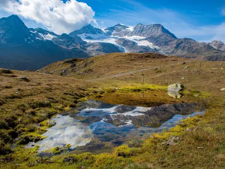
Pendragon Castle, a ruined Norman tower associated with the Mallerstang valley, is another key point on the stage. The emotional finish is the source itself, at Eden Springs on Black Fell Moss, where the river rises on boggy moorland below Hugh Seat.
The highest ground associated with the finish is the Hugh Seat watershed area, around 688–690 m, but the standard route finishes beneath the summit at the source rather than automatically topping out on Hugh Seat. The highest point crossed by the path itself is Johnstone Gill at around 460 m. Some walkers add Hugh Seat as a natural conclusion, but that should only be done if conditions, time and navigation are suitable.
Do not rely on intermediate food or water once beyond Kirkby Stephen unless specific arrangements have been made. Carry a full day’s supplies. Accommodation and services are sparse at the Mallerstang end, so final-night plans around Garsdale, Hawes or elsewhere need to be made well in advance.
Garsdale station is the key public-transport exit and lies on the Settle–Carlisle railway. From Garsdale, the Little White Bus runs to Hawes, but current times and operating days should be checked before travelling. The Moorcock Inn area at Garsdale Head is the usual practical end point after visiting the source.
Navigation is the main warning on this stage. The route is still not waymarked, and the moorland finish can be confusing in poor visibility, especially on wet, peaty ground. If cloud, wind or heavy rain make the source area unsafe or uncertain, the day should be adjusted rather than treated as a routine valley walk.
Recommended Itinerary
The Eden Way is most commonly planned as a 6-day walk, matching the natural rail-and-accommodation points through the Eden Valley. This keeps the route manageable without needing too many small-village overnight stops, which can be awkward to secure, especially towards Mallerstang.
Standard 6-day itinerary
| Day | From | To | Approx. distance | Why this stage makes sense | Services/accommodation notes |
|---|---|---|---|---|---|
| 1 | Rockcliffe | Carlisle | 19 km | A practical opening day from the Solway Firth into the main transport hub of the route. Starting at Rockcliffe also avoids trying to reach a small village at the end of the day. | Rockcliffe has no public transport, so arrange a taxi or lift from Carlisle to the start. Carlisle is the best-served place on the route for rail connections, accommodation and evening supplies. |
| 2 | Carlisle | Armathwaite | 24 km | One of the longer standard days, but it takes the route out of the city and into the quieter Eden Valley, with the red-sandstone river-gorge character beginning to show around Wetheral and Armathwaite. | Armathwaite is a logical overnight stop with rail access nearby on the Settle–Carlisle line. Book ahead rather than assuming same-day availability in a small village. |
| 3 | Armathwaite | Langwathby | 18 km | A shorter day after the long Carlisle–Armathwaite stage, passing the Lazonby, Little Salkeld and Long Meg area before reaching another useful valley stop. | Langwathby has rail access nearby and is one of the recognised overnight points on the standard route. This is a good day to keep some margin for visiting Long Meg and Her Daughters or Lacy’s Caves if time allows. |
| 4 | Langwathby | Appleby-in-Westmorland | 24 km | Another full valley day, continuing upstream through the middle Eden via the Culgaith and Temple Sowerby area to Appleby-in-Westmorland. | Appleby-in-Westmorland is one of the strongest overnight stops on the walk, with accommodation and rail access. This stage is long enough that an early start is sensible, especially if the ground is muddy after rain. |
| 5 | Appleby-in-Westmorland | Kirkby Stephen | 19 km | A moderate penultimate day that positions you at the gateway to the upper Eden and Mallerstang before the wildest section of the route. | Kirkby Stephen is the last main settlement before the moorland finish, so use it for food, onward-weather checks and any kit adjustments. Book accommodation here well ahead in busy periods. |
| 6 | Kirkby Stephen | Garsdale Head via the River Eden source | 21 km | The route changes character completely, leaving the lower valley for the exposed, boggy high ground of Mallerstang and the River Eden source on Black Fell Moss below Hugh Seat. | This is the day that most needs good navigation, weather judgement and proper hill kit. Most walkers finish at Garsdale Head, with Garsdale station on the Settle–Carlisle line; the Little White Bus links Garsdale with Hawes, but current times should be checked before travelling. |
Slower 8–9 day version
A slower itinerary suits walkers who prefer shorter days, want more time for the Eden Valley villages and historic sites, or are carrying heavier packs. It also gives more room for poor weather on the final Mallerstang stage.
The main challenge is not the walking distance but the overnight logistics. Smaller places such as Wetheral, Lazonby, Little Salkeld, Culgaith, Temple Sowerby and Warcop can help break the route, but accommodation is not as dependable as in Carlisle, Armathwaite, Langwathby, Appleby-in-Westmorland and Kirkby Stephen. Where beds do not line up, use the Settle–Carlisle railway or local taxis to return to an accommodation base.
| Day | From | To | Approx. distance | Why this stage makes sense | Services/accommodation notes |
|---|---|---|---|---|---|
| 1 | Rockcliffe | Carlisle | 19 km | The opening section is already a sensible length and ends at the best transport and accommodation hub. | Arrange transport to Rockcliffe from Carlisle. |
| 2 | Carlisle | Wetheral area | Check official mapping before booking | Breaks the long Carlisle–Armathwaite day and gives more time through the lower Eden. | Accommodation and practical access should be checked before committing to this split. |
| 3 | Wetheral area | Armathwaite | Check official mapping before booking | Keeps the red-sandstone gorge section to a relaxed pace. | Armathwaite is a recognised overnight point, but beds should still be booked ahead. |
| 4 | Armathwaite | Lazonby / Little Salkeld area | Check official mapping before booking | Allows time for the Long Meg and Lacy’s Caves area without rushing the day. | Use rail access at or near Lazonby & Kirkoswald if overnight availability is limited locally. |
| 5 | Lazonby / Little Salkeld area | Langwathby | Check official mapping before booking | Creates an easy middle-valley day before the longer approach to Appleby. | Langwathby is a useful rail-side stop. |
| 6 | Langwathby | Culgaith / Temple Sowerby area | Check official mapping before booking | Splits the 24 km Langwathby–Appleby stage into two shorter days. | Accommodation in smaller villages must be checked before booking the rest of the itinerary. |
| 7 | Culgaith / Temple Sowerby area | Appleby-in-Westmorland | Check official mapping before booking | Leaves a shorter approach into Appleby-in-Westmorland, giving more time in the town. | Appleby-in-Westmorland has rail access and is one of the better places to overnight. |
| 8 | Appleby-in-Westmorland | Kirkby Stephen | 19 km | Keeps the standard penultimate day intact and sets up the final high-ground stage. | Book Kirkby Stephen well ahead, especially if baggage transfer or a fixed package is being used. |
| 9 | Kirkby Stephen | Garsdale Head via the River Eden source | 21 km | The final stage is best kept as its own day because it is remote, boggy and exposed. | Check rail times from Garsdale and the Little White Bus to Hawes before travelling. |
Faster version
A faster itinerary only suits strong walkers who are comfortable with long days, self-navigation and limited recovery time. The Eden Way is moderate overall, but compressing it quickly removes the benefit of the valley’s natural overnight spacing and can create a very long day.
The least awkward 5-day version keeps the remote final stage separate and combines two middle stages instead:
| Day | From | To | Approx. distance | Why this stage makes sense | Services/accommodation notes |
|---|---|---|---|---|---|
| 1 | Rockcliffe | Carlisle | 19 km | Keeps the start simple and ends at the main rail hub. | Taxi or lift required to Rockcliffe; stay in Carlisle before or after if needed. |
| 2 | Carlisle | Armathwaite | 24 km | A full but logical day to the next recognised valley stop. | Armathwaite accommodation should be booked ahead. |
| 3 | Armathwaite | Appleby-in-Westmorland | About 42 km | Combines the standard Armathwaite–Langwathby and Langwathby–Appleby stages. This is a long lowland day and should only be considered by walkers already used to this distance. | Start early, carry food, and check mapping carefully. Appleby-in-Westmorland is a practical place to recover because it has accommodation and rail access. |
| 4 | Appleby-in-Westmorland | Kirkby Stephen | 19 km | Avoids arriving at Mallerstang tired late in the day by keeping Kirkby Stephen as the final overnight stop. | Kirkby Stephen is the last main settlement before the exposed finish. |
| 5 | Kirkby Stephen | Garsdale Head via the River Eden source | 21 km | Keeps the boggy, exposed source section as a dedicated day rather than adding it to a longer valley stage. | Do not treat this as an easy final stroll; poor visibility on Mallerstang can make navigation demanding. |
Trying to finish in fewer than 5 walking days is not a normal planning choice for this route. It would require very long stages or transport compromises and would make the unwaymarked final section unnecessarily pressured.
Planning the Route
How many days to allow
Most walkers should plan The Eden Way around the six-stage schedule used in Stuart Greig’s Pocket Routes guide. That gives a practical balance: long enough to follow the river upstream without rushing, but still using the natural overnight stops in the Eden Valley.
The six-day version includes several days around 19–24 km, so it suits walkers who are comfortable with full walking days on consecutive days. The terrain is rarely technical, but the unwaymarked navigation and the exposed final stage mean this is not a route to squeeze into a tight schedule unless fitness, weather and transport are all favourable.
An 8–9 day version is often a better choice for walkers wanting shorter days, more time around Appleby-in-Westmorland, Little Salkeld or the upper Eden, or a lower-risk plan in unsettled weather. Operators such as Brigantes offer self-guided packages with accommodation arranged along the route, including shorter itineraries.
Stage planning and overnight stops
The route is naturally shaped by towns, villages and the Settle–Carlisle railway. Carlisle, Armathwaite, Langwathby, Appleby-in-Westmorland and Kirkby Stephen are the main practical overnight anchors, with Garsdale Head used as the finish after visiting the River Eden source on Black Fell Moss.
The standard six-day split is:
| Day | Stage | Approx. distance | Planning notes |
|---|---|---|---|
| 1 | Rockcliffe to Carlisle | 19 km | Rockcliffe has no public transport, so arrange a taxi or lift from Carlisle to the start. |
| 2 | Carlisle to Armathwaite | 24 km | A longer day through the lower Eden Valley; plan food and daylight accordingly. |
| 3 | Armathwaite to Langwathby | 18 km | A more moderate stage, with the route passing the Little Salkeld area. |
| 4 | Langwathby to Appleby-in-Westmorland | 24 km | Another long valley stage; accommodation and services are more dependable in Appleby than in smaller villages. |
| 5 | Appleby-in-Westmorland to Kirkby Stephen | 19 km | Positions you for the wildest and most committing section the next day. |
| 6 | Kirkby Stephen to Garsdale Head via the Eden source | 21 km | The key mountain-moorland day: boggy, exposed and remote on Mallerstang Edge. |
Stage boundaries vary slightly between guidebooks and operators, particularly where Langwathby, Culgaith or other nearby villages are used as overnight points. Treat any itinerary as a framework, then check current accommodation, rail times and onward transport before booking.
Fast, standard or slower itineraries
A fast itinerary is possible for strong walkers, but it gives little margin for navigation errors, mud, rail timing issues or poor weather on the Mallerstang finish. The route is not waymarked and is not drawn as a named trail on OS maps, so speed should not depend on simply following signs on the ground.
The standard six-day plan works well for fit walkers who want a continuous end-to-end journey. It keeps the day lengths manageable while still requiring proper multi-day pacing.
A slower itinerary is the most forgiving option. It is especially sensible if booking accommodation in smaller villages, walking with a heavy pack, travelling outside the longest summer days, or wanting flexibility for the final climb to the River Eden source.
Section hiking and bail-out options
The Eden Way is unusually practical to section-hike because the Settle–Carlisle railway shadows much of the valley. Useful stations are at or near Carlisle, Armathwaite, Lazonby & Kirkoswald, Langwathby, Appleby, Kirkby Stephen and Garsdale.
This makes it realistic to walk the route over weekends or separate day walks, and it also gives sensible exit points if weather, injury or accommodation problems interrupt a through-hike. Rail times should be checked before travelling, particularly for end-of-day connections from smaller stations.
The start is the exception. Rockcliffe has no public transport, so the first day needs a taxi or lift from Carlisle, around 6 km away. At the far end, Garsdale station is on the route, and the Little White Bus runs between Garsdale and Hawes; current times should be checked before relying on it.
Accommodation and baggage
Accommodation planning matters more than mileage on this route. Carlisle, Appleby-in-Westmorland and Kirkby Stephen are the strongest bases, while smaller villages have fewer beds and less flexibility.
The upper end of the walk needs particular care. Accommodation thins out markedly around Mallerstang, Garsdale and Hawes, so the final nights should be booked well ahead, especially if walking in holiday periods or using a fixed six-day itinerary.
The route can be walked with a full pack, but baggage transfer is available through companies such as Brigantes. This can make the longer 24 km days and the final moorland stage more manageable, provided overnight stops match the operator’s route options.
Food, water and daily supplies
Plan food around the main towns and larger villages rather than assuming regular facilities between them. Carlisle, Armathwaite, Langwathby, Appleby-in-Westmorland and Kirkby Stephen are the logical places to organise meals, packed lunches and evening stops, but opening times and availability should be checked before travelling.
Do not start the final day from Kirkby Stephen under-supplied. The Mallerstang section is more remote, exposed and boggy than the earlier valley walking, and it is not the place to depend on finding food en route.
Carry enough water for each stage, with extra capacity in warm weather or if walking slowly. The route follows the River Eden in broad terms, but that does not mean safe drinking water is automatically available at convenient points.
Navigation planning
Navigation is a core part of planning The Eden Way. The route is not waymarked, and it is not marked on OS maps as a named line, so a guidebook or GPX should be treated as essential rather than optional.
Carry proper mapping as well as any digital file. The recommended OS Explorer sheets are OL5, OL19, OL31 and 315. A phone-only plan is a poor choice for the final stage, where weather, battery life and boggy ground can make decision-making harder.
Lower stages use riverside paths, field tracks, quiet lanes, bridleways and woodland paths, where missed turns can still cost time. The final approach to Black Fell Moss and the high ground below Hugh Seat demands more serious navigation, especially in low cloud.
Weather and the final stage
Most of the route is a spring-to-autumn valley walk, but the last day changes character. From Kirkby Stephen towards Mallerstang, the route climbs to open, peaty, exposed moorland around the Eden source on Black Fell Moss.
This section should be planned as a hill day, not simply the last few kilometres of a riverside walk. Waterproofs, warm layers, reliable navigation and enough food and water are essential, even if the previous days have felt gentle.
The official route finishes at the River Eden source below Hugh Seat rather than requiring a summit of Hugh Seat itself. Some walkers continue to the summit as a natural conclusion, but that adds extra exposed high ground and should depend on weather, daylight and navigation confidence.
Permits, access and checks before departure
No special route permit is a normal planning issue for The Eden Way, which uses established rights of way. The main pre-walk checks are practical ones: accommodation availability, train times, taxi arrangements to Rockcliffe, the Little White Bus from Garsdale to Hawes, and any temporary access changes or diversions.
Because the route is unwaymarked, the most important preparation is having the guidebook or GPX ready before setting off, with map coverage for the full line. Do not rely on finding signs labelled Eden Way on the ground.
Towns, Villages and Overnight Stops
Accommodation on the Eden Way is concentrated in Carlisle, Armathwaite, Langwathby, Appleby-in-Westmorland and Kirkby Stephen, with the Settle–Carlisle railway giving useful access to several stage ends. The smaller villages are useful for breaking up the walk, but should not be assumed to have food, beds or late-opening services without checking first.
For a standard 6-day itinerary, the most practical overnight pattern is Carlisle, Armathwaite, Langwathby, Appleby-in-Westmorland and Kirkby Stephen, then either Garsdale Head / Garsdale or onward to Hawes after the final stage. The upper Eden and Mallerstang end is the tightest part of the route for accommodation, so book the last two nights well ahead.
Rockcliffe
Rockcliffe is the start of the walk, beside Rockcliffe Marsh on the Solway Firth where the Eden reaches the sea. It is not usually an overnight stop unless arranging private accommodation nearby; most walkers base themselves in Carlisle the night before and travel out to the start.
There is no public transport to Rockcliffe. Arrange a taxi or lift from Carlisle, roughly 6 km away, and do not plan to arrive here by train or bus without a pre-booked onward transfer.
Carlisle
Carlisle is the first major overnight stop and the obvious logistical base for the start of the route. The first stage runs from Rockcliffe to Carlisle, so many walkers sleep here both before and after day one if using a standard itinerary.
It has the widest choice of accommodation on the route, including hotels, guesthouses and B&Bs. It is also the best place to sort food, fuel or last-minute kit before the quieter Eden Valley stages.
Transport links are excellent by Eden Way standards: Carlisle is on the West Coast Main Line and the Settle–Carlisle railway. It is the main rail hub for reaching the route and for returning to the start if section-walking.
Wetheral
Wetheral sits on the Carlisle to Armathwaite section, where the Eden begins to cut through red-sandstone gorge and woodland. It is more useful as a natural pause on the walking day than as a core overnight base.
Accommodation and food options should be checked before relying on the village for a stop. The practical issue on this stage is that Carlisle to Armathwaite is a long day, so carry enough food and water rather than assuming services will appear at the right time.
Armathwaite
Armathwaite is one of the key overnight villages on the Eden Way and a standard end point for day two. It sits in attractive Eden gorge country and works well as a compact halt between Carlisle and the middle valley.
Expect a smaller village choice of accommodation rather than the range found in Carlisle or Appleby. Book ahead, especially if walking in peak spring, summer or autumn periods, because the number of beds is limited.
Armathwaite has a station on the Settle–Carlisle railway, making it one of the easiest points for joining, leaving or splitting the walk. This is particularly useful if turning the route into shorter sections.
Kirkoswald
Kirkoswald lies in the middle Eden Valley between Armathwaite and Langwathby. It can be useful for walkers wanting to vary the standard stage pattern, but it is not one of the main listed overnight hubs for the route.
The nearest named railway access in the route information is Lazonby & Kirkoswald station. If planning to sleep here or use it as a start/end point for a section, check the walking distance from the route, current accommodation availability and food options before travelling.
Lazonby
Lazonby is another useful middle-valley settlement, close to the Lazonby & Kirkoswald station on the Settle–Carlisle line. It can help section-walkers shorten or reshape the Armathwaite to Langwathby part of the route.
Do not assume it will function like a full trail town. Check accommodation, evening meals and shop opening before committing to an overnight here, and carry enough food for the day if passing through.
Little Salkeld
Little Salkeld is a notable stopping point rather than a primary overnight base. It sits near two of the route’s important features: Long Meg and Her Daughters, and Lacy’s Caves on the red-sandstone river cliffs.
It is a good place to allow time in the day’s schedule, especially if visiting the stone circle rather than just passing through. Accommodation and food availability should be checked before travelling; walkers on the standard itinerary will usually continue to Langwathby.
Langwathby
Langwathby is a standard overnight stop on the 6-day itinerary, ending the Armathwaite to Langwathby stage and setting up the longer day to Appleby-in-Westmorland. It is one of the more practical middle-route bases because it has rail access.
Accommodation is available in the village/area, but the choice is still much smaller than in Carlisle or Appleby. Book ahead and check evening meal arrangements, particularly outside the busiest walking season.
Langwathby station is on the Settle–Carlisle railway. This makes it a strong option for section-walking or for shortening the route if weather, injury or timing becomes an issue.
Culgaith
Culgaith lies on or near the Langwathby to Appleby-in-Westmorland section. It is relevant mainly because some itinerary variants use slightly different stage boundaries in this part of the valley.
Treat Culgaith as a possible intermediate stop only after checking current accommodation, food and transport arrangements. For most walkers on the standard 6-day schedule, the practical overnight target is Appleby-in-Westmorland.
Temple Sowerby
Temple Sowerby is another village on the approach to Appleby-in-Westmorland. It can be useful as a pacing point on the long Langwathby to Appleby day, but should not be relied on for services without checking ahead.
If planning a shorter or 8–9 day version of the Eden Way, this part of the valley may offer ways to break the standard stage. Accommodation and meal availability should be checked before travelling.
Appleby-in-Westmorland
Appleby-in-Westmorland is one of the best overnight stops on the route. It is a historic market town in a loop of the Eden, with a wider range of accommodation and food options than the smaller villages on either side.
This is the natural place to restock, eat properly and reset before the route becomes progressively quieter towards Warcop, Kirkby Stephen and Mallerstang. It is also a sensible place to build in flexibility if walking shorter stages.
Appleby has a station on the Settle–Carlisle railway, so it works well for section-walking and for joining or leaving the trail. Be aware of the annual Appleby Horse Fair when planning dates, as accommodation and local movement can be heavily affected; this should be checked before travelling.
Warcop
Warcop lies between Appleby-in-Westmorland and Kirkby Stephen. It is mainly an intermediate village on the day’s walk rather than a major accommodation base.
Use it as a possible break point only after checking current services. The safer planning assumption is to carry lunch from Appleby and continue to Kirkby Stephen for the night.
Kirkby Stephen
Kirkby Stephen is the last main settlement before the wild upper Eden and Mallerstang finish. It is the key overnight stop before the final stage and should be treated as a critical booking point.
Accommodation includes the usual mix of small-town walking bases such as B&Bs, inns, guesthouses and small hotels. Book early, because it is the final reliable trail town before accommodation thins out markedly.
Kirkby Stephen has rail access on the Settle–Carlisle line, making it a useful start point for walkers tackling only the final, more upland section. It is also the last sensible place to make sure navigation, waterproofs, warm layers and food are sorted before the exposed moorland finish.
Mallerstang (Outhgill / Pendragon Castle)
Mallerstang is the upper valley section on the final day, between Kirkby Stephen and the River Eden source area. It is a very different proposition from the lower Eden: quieter, more remote and the gateway to the boggy, exposed ground below Hugh Seat.
Outhgill and Pendragon Castle are important landmarks on the final stage. The Jew Stone at Outhgill and the ruined tower of Pendragon Castle are worth allowing time for, but this is not a section where walkers should depend on frequent services.
Accommodation in and around the upper valley is limited. If trying to split the final day or stay near Mallerstang, book well ahead and check food arrangements carefully.
Garsdale Head
Garsdale Head is the practical end point for most walkers after visiting the River Eden source on Black Fell Moss. The Moorcock Inn area is commonly used as the finish point, with Garsdale station providing the crucial onward transport link.
This is not a large trail town, so do not arrive assuming multiple beds, meals or fallback options. Accommodation around Garsdale, Garsdale Head and onward towards Hawes should be booked well ahead, especially if walking at busy times.
Garsdale station is on the Settle–Carlisle railway and lies on the route’s finish logistics. From Garsdale, the Little White Bus runs to Hawes, but current times and operating days should be checked before travelling.
Getting to the Start
The Eden Way starts at Rockcliffe, beside Rockcliffe Marsh on the Solway Firth north-west of Carlisle, where the River Eden meets the sea. The practical gateway is Carlisle: it has the main rail connections, accommodation, services and taxi options needed to reach the actual trailhead.
Rockcliffe itself has no public transport, so the final approach to the start is normally by taxi or lift from Carlisle. The start is around 6 km from Carlisle, and the approximate grid reference is NY332619; give the driver the Rockcliffe Marsh / River Eden start point rather than just assuming they know the walking route.
By train
Carlisle is the nearest useful railway station for the start. It sits on the West Coast Main Line and also connects with the Settle–Carlisle line, which later becomes useful for section-walking and for returning from the finish at Garsdale.
From Carlisle station, take a taxi or pre-arranged lift to Rockcliffe. Do not plan on starting directly from the railway unless adding the extra road/approach distance deliberately; the recognised route begins at Rockcliffe, not Carlisle.
Train times, fares and any engineering works should be checked before travelling, especially if arriving late and relying on a same-day taxi transfer to the start.
By bus
Rockcliffe has no public transport for practical trail access. Bus travel is therefore not a dependable way to reach the start of the Eden Way.
If using buses to reach Carlisle from elsewhere, treat Carlisle as the public-transport endpoint and arrange a taxi or lift onwards to Rockcliffe. Local bus options and onward taxi availability should be checked before travelling.
By car
Driving to the start is possible, but it creates a point-to-point logistics problem: the route finishes at Garsdale Head / Garsdale on the Settle–Carlisle line, not back at Rockcliffe. Most drivers will find it simpler to leave the car in Carlisle, arrange a taxi to Rockcliffe for the start, then return by train from Garsdale to Carlisle after finishing.
Long-stay parking arrangements in Carlisle should be checked before travelling. Do not assume there is suitable long-stay parking at Rockcliffe itself; no dedicated trail parking is built into the route logistics.
If using two cars, Rockcliffe can be used as the northern drop-off point and Garsdale as the southern retrieval point, but the upper end is more remote and accommodation and transport are thinner. This needs planning rather than leaving the return journey to the final day.
From the nearest airport
No airport sits conveniently at the trailhead. For walkers flying in, the practical plan is to use an airport with onward rail access to Carlisle, then take a taxi or lift from Carlisle to Rockcliffe.
Because flight arrivals, rail connections and taxi availability can all affect the same-day start, allow a buffer or stay in Carlisle the night before walking. This should be checked before travelling.
Where to stay before starting
Carlisle is the most practical place to stay before starting the Eden Way. It has the rail station, services, food options and taxi access needed for an early transfer to Rockcliffe, and the first day’s stage returns to Carlisle after starting at the Solway Firth.
Staying in Carlisle also avoids beginning the walk after a long journey. A common arrangement is to arrive by train, stay overnight in Carlisle, take a pre-booked taxi to Rockcliffe in the morning, then walk the first stage back to Carlisle.
Accommodation at the start itself should not be relied on unless booked and checked in advance. Rockcliffe is a small start point rather than a transport hub, so Carlisle is the safer base for the night before the walk.
Getting Home from the Finish
The Eden Way finishes high on Black Fell Moss below Hugh Seat, at the River Eden source. In practical terms, most walkers complete the route by descending to Garsdale Head, with Garsdale station on the Settle–Carlisle line providing the key onward transport link.
Do not treat the source itself as a transport point. The final stage is remote, boggy and exposed, so build enough daylight into the day to reach Garsdale Head or Garsdale station safely before relying on any onward connection.
By train
Garsdale station is the nearest railway station and the most useful way out from the finish. It sits on the Settle–Carlisle railway, the same line that shadows much of the Eden Valley and links back towards the main rail network.
From Garsdale, walkers can use the Settle–Carlisle line to travel north back towards Carlisle, the main rail hub at the northern end of the route, with onward West Coast Main Line connections. The line also serves Eden Way places including Kirkby Stephen, Appleby, Langwathby, Lazonby & Kirkoswald, Armathwaite and Carlisle, which makes it useful for returning to earlier accommodation, a parked car, or a staged-walk base.
Train services on rural lines are timetable-dependent, and late-day options may be limited. Check current train times before committing to a finish-day connection, especially if walking the full final stage from Kirkby Stephen over Mallerstang in poor weather or short daylight.
By bus
From Garsdale, the Little White Bus runs to Hawes. This can be useful if accommodation has been booked in Hawes or if linking the Eden Way with onward walking in the Yorkshire Dales.
The service should be treated as limited and timetable-dependent rather than a turn-up-and-go option. Check the current Little White Bus timetable before travelling, and do not assume there will be an evening bus after a slow final day on the moor.
By car/taxi
If being collected by car, the practical pick-up point is Garsdale Head / Garsdale station, not the Eden source. Make sure the driver understands that the official end is on open moorland and that the walking finish normally continues out to the road and station area.
Taxis in the upper Eden and Mallerstang area should be pre-booked. Do not rely on finding an available taxi at Garsdale station at short notice, particularly on Sundays, public holidays or late in the day. If returning to Kirkby Stephen, Appleby-in-Westmorland or Carlisle, compare a pre-booked taxi with the Settle–Carlisle train before deciding.
For walkers leaving a car earlier on the route, the railway is usually the cleanest solution: finish at Garsdale, then take the train back to the relevant Eden Valley station. Current rail times and any parking arrangements should be checked before travelling.
From the nearest airport
There is no airport transport at the finish. The realistic strategy is to leave the trail by train from Garsdale, then connect through larger rail hubs such as Carlisle for onward long-distance travel.
Airport choice and rail connections depend on where the journey home is heading, so check current rail and airport-link timings before booking flights. Build in a buffer after the final stage; a tight same-day flight connection is risky after a remote, weather-exposed moorland finish.
Where to stay at the finish
Accommodation is sparse at the upper end of the route, so the final night should be planned early. Many walkers either stay around Kirkby Stephen before the last stage, or finish at Garsdale Head, where the Moorcock Inn is the landmark finish-point area noted for the route.
If there is any doubt about catching an onward train or bus, staying near the finish is the safer plan. This is especially sensible after bad weather, a late start from Kirkby Stephen, or if adding the optional continuation to Hugh Seat above the Eden source.
Availability around Mallerstang, Garsdale and Hawes can be limited, so book ahead and confirm current opening, accommodation and meal arrangements before relying on them.
Which Direction Should You Walk?
The Eden Way is best walked in its standard direction: south and upstream from Rockcliffe to the River Eden source on Black Fell Moss, finishing at Garsdale Head. This is the traditional line of the route and gives the walk its clear purpose — following the Eden from sea to source.
Walking in reverse is possible, but it is less natural for both navigation and the overall shape of the journey. The route is not waymarked or marked on OS maps, so whichever direction you choose, use the guidebook or GPX with the relevant OS Explorer maps.
| Direction | Main advantages | Main drawbacks |
|---|---|---|
| Rockcliffe to Garsdale Head | Traditional sea-to-source journey; scenery builds from Solway Firth and Eden Valley to Mallerstang; strong final-day finish at the source; transport works well at the end via Garsdale station | The start at Rockcliffe has no public transport, so a taxi or lift from Carlisle is needed; the hardest, wildest ground comes on the final stage |
| Garsdale Head to Rockcliffe | Starts from the Settle–Carlisle line; the high moorland is tackled early; later stages become lower and gentler | Finishes at Rockcliffe, which has no public transport; the route’s main climax comes at the beginning; less satisfying as a river-source walk |
Transport and accommodation flow
For most walkers, the standard direction is simpler overall. Rockcliffe has no public transport, but it is only a short taxi or lift from Carlisle, which is the main northern rail hub. Once that awkward first transfer is dealt with, the walk then finishes at Garsdale Head, with Garsdale station on the Settle–Carlisle line.
In reverse, the start is convenient if arriving by train at Garsdale, but the finish is less tidy. Ending at Rockcliffe means arranging a taxi or lift back to Carlisle after the final stage, rather than stepping onto the railway at the end of the walk.
Accommodation also favours the standard direction. The route moves through Carlisle, Armathwaite, Langwathby, Appleby-in-Westmorland and Kirkby Stephen before reaching the thinner accommodation at the upper Eden and Mallerstang end. Those final nights still need booking well ahead, but the build-up through larger settlements gives a more practical progression.
Scenery and sense of journey
The standard direction gives the best scenic progression. The route begins beside Rockcliffe Marsh on the Solway Firth, follows the Eden through Carlisle, sandstone gorges, farmland, woodland and market towns, then narrows into the upper valley before the final climb to the river’s source below Hugh Seat.
That finish matters. Reaching Black Fell Moss and Eden Springs gives the walk a clear end-point, with the option for some walkers to continue to Hugh Seat as a natural high-level conclusion.
In reverse, the most remote and dramatic section comes immediately. The remaining days then become progressively lower and gentler, which can suit some walkers physically, but it weakens the route’s sea-to-source logic.
Climbs, weather and difficulty by direction
The Eden Way is not a technically difficult route in either direction. Most of the walking is on riverside paths, field tracks, quiet lanes, bridleways and woodland paths.
The main directional difference is the final Mallerstang section. Walked southbound, the route saves the exposed, boggy moorland climb to the source for the last day. Walked northbound, that same high ground is encountered at the start, before the route settles into the lower Eden Valley.
There is no dependable wind advantage that should determine the direction. Weather matters most on the exposed Mallerstang moorland, where poor visibility, rain and wind make navigation more serious. This stage should be planned around the forecast in either direction.
Recommendation
Walk Rockcliffe to Garsdale Head unless there is a specific reason to reverse it. The standard southbound, upstream direction gives the Eden Way its strongest narrative, the best scenery progression, a more satisfying finish at the source and better end-of-walk transport from Garsdale station.
Accommodation Along the Route
The Eden Way is very workable as an inn-to-inn walk, but it needs more advance planning than busier, waymarked trails. The strongest accommodation bases are Carlisle, Appleby-in-Westmorland and Kirkby Stephen, with smaller-scale options in Armathwaite and Langwathby. Beds thin out sharply beyond Kirkby Stephen towards Mallerstang and Garsdale Head.
The standard 6-day itinerary uses logical overnight stops at Carlisle, Armathwaite, Langwathby, Appleby-in-Westmorland and Kirkby Stephen, then finishes at Garsdale Head after reaching the source area on Black Fell Moss. This pattern keeps each day manageable, but it leaves little margin if a preferred village is full, so book the whole route before committing to travel.
| Place | Accommodation level | Best for | Notes |
|---|---|---|---|
| Rockcliffe | Limited | Route start only | The walk starts at Rockcliffe, but it is not the practical base for most walkers. There is no public transport to the start, so most itineraries use Carlisle the night before and arrange a taxi or lift to Rockcliffe. |
| Carlisle | Good | Pre-walk night and Day 1 overnight | The main northern hub for the route, with the best transport links and the widest choice of places to stay. Also the obvious base for reaching Rockcliffe at the start. |
| Armathwaite | Limited | Day 2 overnight | A useful village stop after the long Carlisle–Armathwaite stage. Book ahead, as village accommodation is naturally more limited than in Carlisle or Appleby. |
| Langwathby | Limited | Day 3 overnight | A standard overnight point on the 6-day schedule. Availability should be checked early, especially if walking at weekends or in the main season. |
| Appleby-in-Westmorland | Good | Day 4 overnight and resupply/rest logistics | One of the best accommodation stops on the trail and a sensible place to build in flexibility. Check local dates before booking, as the Appleby Horse Fair can put exceptional pressure on beds in and around the town. |
| Kirkby Stephen | Good | Day 5 overnight; final main base before Mallerstang | The last main settlement before the wild upper Eden and Mallerstang finish. This is the key place to secure before attempting the final stage. |
| Mallerstang / Outhgill area | Limited | Breaking up or positioning for the final valley section | Accommodation becomes sparse in the upper valley. Do not rely on finding a bed here late in the planning process. |
| Garsdale Head | Limited | Finish logistics after the source | The route commonly ends the walking day at Garsdale Head after visiting the River Eden source. The Moorcock Inn area and Garsdale station make this a practical finish point, but beds and onward transport should be checked before travelling. |
| Hawes | Limited | Off-route fallback after finishing | Some walkers use the Garsdale–Hawes Little White Bus after finishing, but current service times and accommodation availability should be checked before relying on this option. |
Booking strategy
Book Carlisle, Appleby-in-Westmorland and Kirkby Stephen first, then fill the smaller overnight stops around them. The upper-valley section is the least forgiving: if Kirkby Stephen, Mallerstang or Garsdale-area accommodation is full, the final day becomes awkward without a taxi transfer or public-transport workaround.
For the standard 6-day schedule, the most important nights to secure early are Armathwaite, Langwathby, Kirkby Stephen and the finish-night arrangement at Garsdale Head or beyond. These are the points where limited local capacity can affect the whole itinerary.
Spring, summer and early autumn are the normal walking seasons, so weekends and holiday periods can fill quickly. Appleby-in-Westmorland needs particular attention around the Appleby Horse Fair, when accommodation pressure can extend beyond the town itself.
Using luggage transfer, taxis and rail to solve gaps
The Settle–Carlisle railway is unusually useful for this route, with stations at or near Carlisle, Armathwaite, Lazonby & Kirkoswald, Langwathby, Appleby, Kirkby Stephen and Garsdale. This makes it possible to stay in a stronger accommodation base and travel back to a stage start or end, provided train times work for the day. This should be checked before travelling.
Taxi transfers can also solve awkward accommodation gaps, particularly at Rockcliffe at the start and around the upper Eden/Mallerstang end. Do not assume a late-evening rural taxi will be available without booking it in advance.
Companies such as Brigantes offer self-guided Eden Way packages with accommodation arranged along the route, and baggage transfer can remove much of the logistical friction. This is a good option for walkers who want an inn-to-inn route but do not want to carry full multi-day kit or coordinate the smaller village stops independently.
Camping and budget options
The route has some camping possibilities, but the Eden Way should not be treated as a simple campsite-to-campsite trail unless each night has been planned in advance. The same issue applies as with indoor accommodation: options are easier around the main valley towns and thinner towards Mallerstang and Garsdale Head.
Wild, high ground near the source is exposed, boggy and remote, so the final stage should be planned as a walking day to a definite finish point rather than as an improvised overnight on the moor. Proper accommodation or transport away from Garsdale Head should be arranged before setting out from Kirkby Stephen.
Camping and Wild Camping
Camping is possible on the Eden Way, but it needs more planning than on a waymarked National Trail with regular trail-side campsites. The route passes through a working river valley of farms, villages, wooded gorges and market towns before finishing on exposed Mallerstang moorland, so pitches cannot simply be assumed at the end of each day.
For most walkers, the easiest camping strategy is to use booked campsites or established accommodation near the main settlements: Carlisle, Armathwaite, Lazonby / Langwathby, Appleby-in-Westmorland and Kirkby Stephen. The upper Eden and Mallerstang end is much thinner for places to stay, so the final night or any camping around Kirkby Stephen, Garsdale Head or Hawes should be arranged well ahead. This should be checked before travelling.
Does the Eden Way suit camping?
The Eden Way can be backpacked, but it is not the most convenient route for a first camping trip. Several standard stages are around 19–24 km, and carrying camping kit will make the long central days and the final climb to the source more demanding.
The lower and middle valley sections are the most practical for camping because they pass through or near larger settlements and the Settle–Carlisle railway provides useful escape points. The final Kirkby Stephen to Garsdale Head stage is much less forgiving: it climbs onto boggy, exposed moorland on Mallerstang Edge and should not be treated as a casual place to find a pitch at the end of the day.
Campsites and booking
No single campsite chain or official camping infrastructure defines this walk, so camping places should be identified and booked stage by stage. Do not rely on arriving in a village and finding a legal pitch, particularly in the upper valley.
When planning an itinerary, check camping options near the likely stage ends rather than only on the exact line of the route. Short diversions may be necessary, and the railway stations at Carlisle, Armathwaite, Lazonby & Kirkoswald, Langwathby, Appleby, Kirkby Stephen and Garsdale can help if a campsite is not available exactly where a walking day naturally ends.
Wild camping law and practical reality
Wild camping is not a general legal right in England. On the Eden Way, assume that camping on farmland, riverbanks, woodland, moorland or near buildings requires the landowner’s permission unless there is a clearly advertised legal camping arrangement.
This matters especially on the Eden Way because much of the route crosses enclosed agricultural land and riverside rights of way. A public footpath gives a right to pass and repass; it does not give a right to camp beside it.
The Mallerstang finish may feel remote, but that does not make it a free-camping area. The ground around Black Fell Moss and the source of the River Eden is boggy, exposed and sensitive, and weather can deteriorate quickly. It is better treated as a place to visit and move through, not as an assumed overnight stop.
Water and food for campers
The route follows the River Eden for much of its length, but river water should not be treated as a reliable drinking source. The lower and middle valley passes through farmland and settlements, so water should be refilled from accommodation, cafés, pubs, shops or other safe supplies where available.
On the final stage, carry enough water from Kirkby Stephen for a long, exposed day unless a safe refill has been planned. Moorland streams and springs should be treated if used, and their availability can vary with weather.
Food planning is also important. Carlisle, Appleby-in-Westmorland and Kirkby Stephen are the main places to resupply; smaller villages may not have everything a backpacker needs. This should be checked before travelling.
Leave No Trace and fire rules
If permission is granted for a discreet wild camp, keep it genuinely low-impact: arrive late, leave early, use a small tent, avoid livestock, gates, crops and buildings, and leave no trace of the pitch. Pack out all rubbish, including food waste and sanitary items.
Do not light open fires. Use a camping stove only where it is safe and permitted, and take particular care in dry spells, woodland, farmland and on open moorland.
Human waste should be dealt with responsibly and well away from watercourses, paths, walls, buildings and grazing animals. The River Eden and its tributaries are a core part of the route, so protecting water quality is particularly important.
Best camping approach for this route
For most independent walkers, the most reliable plan is a hybrid itinerary: use booked campsites where they fit the day, and use B&Bs, inns or guesthouses in the thinner sections. This is especially sensible for the final approach to Mallerstang and Garsdale Head, where accommodation and camping options are limited and the day is more exposed.
Anyone intending to camp throughout should build the itinerary around confirmed pitches first, then adjust walking distances around them. The Eden Way is unwaymarked and the final moorland section is navigationally serious, so camping should reduce logistical pressure, not create a late-day search for somewhere to sleep.
Food, Water and Resupply
The Eden Way is not a wilderness route for most of its length, but it is a rural valley walk with several long stages where food cannot be assumed between overnight stops. Plan each day as a self-sufficient walking day: breakfast before setting off, lunch carried, and enough snacks to cover delays, mud, navigation checks and slower going on field paths.
Carlisle is the easiest place to buy food near the start. Appleby-in-Westmorland and Kirkby Stephen are the other key resupply points, with Kirkby Stephen especially important before the final stage into Mallerstang and up to the River Eden source. Smaller places such as Wetheral, Armathwaite, Langwathby, Culgaith, Temple Sowerby, Warcop and Outhgill should be treated as possible refreshment stops rather than guaranteed resupply points; rural opening hours, pub food times and Sunday trading can make them unreliable without checking ahead.
Water strategy
Do not rely on the River Eden as a drinking-water source without treatment. The route spends much of its time beside or near the river, but the lower and middle valley is agricultural, and the final moorland section is peaty and boggy. If natural water is used, it should be filtered or treated.
The most reliable water is from accommodation, pubs, cafes and other staffed premises when open. Start each stage with a full day’s supply, especially on the longer 24 km days and on the final Kirkby Stephen to Garsdale Head stage, where services thin out and the route finishes on exposed moorland. In warm weather, carry extra rather than assuming a refill will appear at the next village.
Food and water by section
| Section | Food availability | Water availability | Notes |
|---|---|---|---|
| Rockcliffe to Carlisle | Limited at the start; Carlisle is the first major resupply point. | Carry water from the start or from your accommodation/transport base in Carlisle. | Rockcliffe has no public transport and should not be treated as a services hub. Start with food and water already sorted. |
| Carlisle to Armathwaite | Carlisle offers the best chance to buy breakfast, lunch supplies and snacks before leaving. Wetheral may offer refreshments, but this should be checked before travelling. | Refill before leaving Carlisle; possible refills only where premises are open. | This is one of the longer standard stages, so carry lunch rather than depending on finding food mid-stage. |
| Armathwaite to Langwathby | Rural village-to-village walking; food availability can be limited outside accommodation, pubs or cafes. | Fill up before departure; ask accommodation or open premises for refills where possible. | Lazonby, Kirkoswald and Little Salkeld are on or near this part of the valley, but do not assume shop-style resupply without checking current opening. |
| Langwathby to Appleby-in-Westmorland | Limited between the start and Appleby; possible refreshment stops depend on rural opening hours. | Carry enough from Langwathby for the full stage. | At around 24 km, this is a poor stage on which to gamble on lunch en route. Appleby-in-Westmorland is the main resupply target at the end of the day. |
| Appleby-in-Westmorland to Kirkby Stephen | Appleby is a key place to stock up before leaving; Kirkby Stephen is the next important resupply point. | Start full from Appleby; refill only where open premises are available. | Warcop lies on this section, but services should be checked before relying on them. Buy supplies in Appleby for the walking day and in Kirkby Stephen for the final stage. |
| Kirkby Stephen to Garsdale Head via the Eden source | Carry all food from Kirkby Stephen. Do not rely on buying food in Mallerstang before the finish. | Carry enough water from Kirkby Stephen for the day; natural water on the moor should be filtered or treated. | This is the most exposed and remote food-and-water section of the route. The walk passes through Mallerstang and the Outhgill / Pendragon Castle area before the high, boggy finish near Black Fell Moss. |
Practical resupply advice
Book accommodation with breakfast where possible, and ask in advance whether packed lunches are available. This is particularly useful on the longer rural stages, where a pub or cafe may be closed, may not serve food at walking hours, or may be off your exact line.
Carry an emergency meal or at least substantial spare food for the final two days. The upper Eden and Mallerstang end of the route has fewer services, and poor weather on the moorland finish can slow progress significantly.
Opening hours in the Eden Valley should be checked before travelling, especially on Sundays, bank holidays and outside peak summer. A place name on the map is not a guarantee of an open shop, pub kitchen or cafe at the time you pass through.
Terrain, Conditions and Difficulty in Practice
The Eden Way is moderate because of distance, navigation and the final moorland finish, not because of technical terrain. For most of its length it is a low-level valley walk on riverside paths, field tracks, bridleways, woodland paths and quiet country lanes through the Eden Valley. There is no scrambling and no sustained mountain ground until the route reaches the upper Mallerstang end.
The character changes sharply on the last stage from Kirkby Stephen towards Garsdale Head. The route leaves the gentler valley walking and climbs onto open, peaty moorland around Black Fell Moss and the Eden source below Hugh Seat. In poor visibility, strong wind or wet ground, this final section feels much more serious than the earlier days.
Surfaces underfoot
Expect a mix of grass field paths, earth tracks, woodland paths, bridleways and minor lanes. The easiest going is generally on tracks and lanes; the slower sections are the riverside and farmland stretches, where the line may be less obvious and ground can be wet after rain.
The red-sandstone gorges around Wetheral and Armathwaite give some of the most enclosed and distinctive walking on the route. These are still walking paths rather than technical ground, but wooded riverside paths can be muddy and slower when wet.
The upper route on Mallerstang Edge is the main underfoot challenge. The finish at the Eden source on Black Fell Moss is on boggy, exposed moorland, so waterproof boots and the ability to keep moving confidently across wet peat are important.
Road walking and lanes
The route uses quiet country lanes in places, which helps with pace and makes some stages less physically demanding than the mileage alone suggests. These lane sections are part of the practical character of the walk: useful for steady progress, but less forgiving on feet over long days than softer paths.
There is no indication that road walking is the dominant terrain, but it is enough to make cushioned footwear and good blister management worthwhile. On narrow rural lanes, walk facing oncoming traffic where safe and stay alert around bends.
Climbs, descents and exposure
Total ascent is about 2,080 m over the full 129 km, so the climbing is spread out rather than concentrated into repeated big hill days. Most stages are valley walking with modest undulations, which is why the route suits reasonably fit walkers rather than only experienced hillwalkers.
The final stage is the exception. The route climbs from the upper Eden around Kirkby Stephen and Mallerstang towards the source area on Black Fell Moss, with the highest point the path itself crosses given as Johnstone Gill at 460 m. The higher 688–690 m figure associated with the finish area refers to Hugh Seat and the watershed above the source; Hugh Seat is a natural optional continuation, not a summit the main route necessarily tops out on.
Exposure matters more than height here. Once on the upper moorland, there is less shelter, the ground is wetter, and navigation mistakes are more consequential than in the valley.
Mud, bog and seasonal conditions
Lower Eden Valley sections can be muddy after rain, especially on riverside paths, field paths and woodland stretches. Spring and autumn are often the seasons when footwear choice matters most, as soft ground can slow progress even on otherwise gentle stages.
Summer usually gives the best chance of drier underfoot conditions, but long grass, warm weather and limited shade on some open sections can still make the longer 24 km days tiring. Carrying enough water between settlements remains important, particularly on the longer central stages.
The Mallerstang finish should be treated as hill terrain in any season. Boggy peat around Black Fell Moss, low cloud, wind and rain can turn the last day from a straightforward finale into a demanding navigation exercise.
Navigation difficulty
The Eden Way is not waymarked and is not marked as a named route on OS maps. That is one of the biggest practical difficulties of the walk. A guidebook or GPX should be used alongside the relevant OS mapping, and walkers should be comfortable identifying field paths, river crossings, lanes and moorland lines without relying on signs.
Navigation is most important in two situations: across farmland where paths and field boundaries can make the line less obvious, and on the final open moorland section where visibility may drop quickly. The route is not technically hard, but poor navigation can easily make a long day longer.
Stage-by-stage difficulty in practice
| Stage | Practical terrain character | Main difficulty |
|---|---|---|
| Rockcliffe to Carlisle | Low-level walking from the Solway-side start near Rockcliffe Marsh towards Carlisle | Navigation and settling into the route; the start has no public transport, so logistics matter before the walking begins |
| Carlisle to Armathwaite | Long day with riverside, field, woodland and gorge walking around Wetheral and Armathwaite | Distance: at about 24 km, this is one of the longer stages |
| Armathwaite to Langwathby | Gentler Eden Valley walking through farmland, riverside and village country | Mud after rain and route-finding across rural rights of way |
| Langwathby to Appleby-in-Westmorland | Another long valley day, mixing tracks, field paths, lanes and riverside walking | Distance again: about 24 km, with accumulated fatigue more significant than terrain |
| Appleby-in-Westmorland to Kirkby Stephen | Upper Eden valley walking, still mostly non-technical | A transitional day before the wilder finish; accommodation and onward logistics become more important |
| Kirkby Stephen to Garsdale Head via the Eden source | The route changes to open, peaty, exposed moorland around Mallerstang and Black Fell Moss | The hardest terrain and navigation of the whole walk, especially in poor weather |
What makes it feel easier or harder
The Eden Way feels easier when split into shorter stages, when paths are dry, and when the guidebook or GPX line is followed carefully from the start. The Settle–Carlisle railway also reduces pressure, because several valley settlements have stations at or nearby.
It feels harder when walked in the standard six-day format, because several days are close to 24 km and the final stage is not simply a gentle walk to a village finish. After five days on softer valley ground, the climb onto wet, exposed moorland can be a real step up.
Overall, fit walkers with sound navigation should find the route manageable. Those expecting waymarks, consistently dry paths or a lowland finish may underestimate it.
Weather and Best Time to Walk
The Eden Way is best planned for spring, summer or early autumn, when daylight is long enough for the 18–24 km valley stages and the final crossing towards Black Fell Moss is less likely to be made difficult by winter conditions. The route is mostly low-level through the Eden Valley, but the last day from Kirkby Stephen to the River Eden source changes the character of the walk: it is open, peaty, exposed moorland and needs proper hill-walking weather judgement.
Best months
For most walkers, the most practical window is late spring to early autumn. This gives better daylight for the longer stages, more forgiving conditions on field paths and riverside tracks, and a better margin for navigating the unwaymarked route.
Summer is the easiest season for daylight, but it is also when accommodation pressure can be higher in the main valley towns and villages. The upper-valley and Mallerstang end has fewer beds at any time of year, so Kirkby Stephen, Garsdale Head and any onward accommodation around Hawes should be booked well ahead.
Autumn can be a good time for the lowland sections, but short days become a real planning factor. On the final stage, slower progress over boggy ground, poor visibility or a navigation error can quickly turn a 21 km day into a late finish.
Weather risks by season
| Season | What matters for hikers |
|---|---|
| Spring | Usually a sensible walking season, but expect wet ground after rain, especially on field paths and lower riverside sections. The Mallerstang finish can still feel cold and exposed in wind or hill fog. |
| Summer | Best daylight and generally the simplest season logistically. Carry enough water between services and protect against sun on open lanes, farmland and moorland, but still pack waterproofs: the final stage is exposed and has little shelter. |
| Autumn | Often still viable, but daylight shortens and wet ground becomes more likely. Plan early starts on the longer days, especially Langwathby to Appleby-in-Westmorland and Kirkby Stephen to Garsdale Head. |
| Winter | Not the recommended season for a standard end-to-end walk. Short daylight, cold rain, boggy moorland, wind, fog and possible snow or ice on the high ground around Mallerstang make the final day much more serious. Winter attempts should be treated as hill days, not valley walking. |
Rain, mud and underfoot conditions
Lower down, the route uses riverside paths, field tracks, bridleways, quiet lanes and woodland. After wet weather, expect mud on the lower Eden sections and slower going through farmland and wooded river corridors, including around the red-sandstone gorges at Wetheral and Armathwaite.
The final approach to the source on Black Fell Moss is the key weather-sensitive part of the walk. The ground is peaty and boggy, and the route climbs into exposed moorland below Hugh Seat. Waterproof boots, full waterproofs, warm layers, gloves and a reliable navigation set-up are sensible even in summer.
Wind, fog and navigation
The Eden Way is not waymarked and is not marked on OS maps, so poor visibility matters more than on a signed National Trail. In valley sections this mainly means slower map-and-GPX work through fields, lanes and riverside paths. On Mallerstang Edge, mist, low cloud or strong wind can make the finish at the River Eden source significantly harder to locate and less forgiving.
Do not leave the final stage to a day with a poor forecast unless equipped and confident for open moorland navigation. If conditions are deteriorating, the Settle–Carlisle railway access at Kirkby Stephen and Garsdale is useful for changing plans, but train and bus times should be checked before travelling.
Daylight and stage planning
The standard six-day itinerary includes several long days of around 24 km, so daylight is a practical issue outside high summer. In spring and autumn, start early and avoid overloading the day with long pub stops, sightseeing detours or late transport connections.
The final day from Kirkby Stephen to Garsdale Head should have the biggest weather margin. It includes the remote high finish at the River Eden source and is the stage least suited to being rushed late in the day.
Accommodation and seasonal pressure
There are no large resort-style accommodation clusters along much of the route. Beds are concentrated in places such as Carlisle, Armathwaite, Langwathby, Appleby-in-Westmorland and Kirkby Stephen, then thin out markedly towards Mallerstang and Garsdale Head.
In the main walking season, book ahead rather than relying on turning up, especially for the final nights. Accommodation in and around Appleby-in-Westmorland can also be affected by major local events such as the Appleby Horse Fair, so availability should be checked before fixing an itinerary.
Insects and ticks
The route crosses farmland, long grass, woodland edges and moorland, so standard UK tick precautions are sensible in the warmer months. Wear long trousers where practical, use repellent if needed, and check carefully after walking through grassy or bracken-like vegetation.
Seasonal closures and winter realism
There are no routine seasonal closures to build the plan around, but access changes, diversions and local path issues should be checked before travelling.
A winter Eden Way is possible only for walkers comfortable with short days, wet lowland paths and serious moorland weather on the final stage. For most independent hikers, the route is far more practical between spring and autumn, with the best balance of daylight, accommodation availability and underfoot conditions outside the depths of winter.
Safety Notes
Emergency help
In an emergency in the UK, call 999 or 112. On the open fell and moorland sections, ask for Police, then Mountain Rescue; for immediate medical emergencies in towns, villages or on roads, the operator will direct the appropriate service.
Mobile signal should not be relied on throughout the route, particularly on the upper Eden and Mallerstang finish. Carry a charged phone, a power bank, offline mapping and a paper map/guidebook, and make sure someone knows the day’s intended finish and any bail-out plan.
Navigation risk
The Eden Way is not waymarked and is not marked as a named route on OS maps. The main safety issue for most walkers is therefore not technical terrain, but staying on the correct rights of way through farmland, woodland, lanes and riverside paths.
Carry the guidebook or GPX as well as suitable OS mapping, and check the day’s route before leaving accommodation. In poor visibility on Mallerstang Edge, do not rely on a phone screen alone; the moorland around Black Fell Moss and the Eden source is boggy, exposed and easy to make slower than expected.
Weather and exposure
Most of the route through the Eden Valley is low-level, but it is still exposed to rain, wind and cold in places. The final stage from Kirkby Stephen towards the River Eden source changes character completely, climbing onto open, peaty moorland below Hugh Seat before finishing near Garsdale Head.
For that last day, carry full waterproofs, warm layers, hat and gloves outside high summer, and enough food and drink to cope with delays. If conditions are poor, the optional continuation to Hugh Seat should be treated as just that: optional.
Heat can also be a problem on the long central stages, especially the roughly 24 km days between Carlisle and Armathwaite, and between Langwathby and Appleby-in-Westmorland. Start early in warm weather, carry sufficient water, and avoid relying on finding services between villages unless planned in advance.
Rivers, gorges and wet ground
The route follows or approaches the River Eden for much of its length. After heavy rain, lower riverside paths can be muddy and slippery, and the red-sandstone gorge sections around Wetheral and Armathwaite need care underfoot.
Stay back from eroded or slippery riverbanks, especially where woodland paths run above the water. Do not enter the river to shorten the route or bypass an obstruction; turn back or use a safe legal alternative if a path is blocked. Any current path closures or diversions should be checked before setting off each day.
Near Rockcliffe Marsh at the start, keep to the intended route and rights of way rather than wandering onto marshy ground. The finish area on Black Fell Moss is also wet underfoot, so waterproof boots and careful foot placement are sensible even in a dry spell.
Roads, lanes and village sections
The Eden Way uses quiet country lanes as well as paths, tracks and bridleways. Treat these lanes seriously: traffic may be infrequent but can appear quickly on bends, over crests or between hedges.
Walk on the safest side for visibility, step in where necessary, and use a small light or reflective item if starting early, finishing late or walking in poor weather. Extra care is needed when tired at the end of longer stages, as concentration often drops on the easier-looking lane sections.
Livestock and farmland
Much of the Eden Valley walking is through working farmland. Leave gates as found, follow the right of way, and give cattle and sheep plenty of space.
If cattle are present, move calmly and avoid getting between cows and calves. Dogs should be kept under close control, and on a lead where livestock or ground-nesting birds may be present; if cattle threaten a dog walker, release the dog rather than trying to hold it.
Solo walking and bail-out planning
The route is suitable for competent independent walkers, but solo hikers should be conservative about day length, weather and navigation. This is especially true on the final Kirkby Stephen to Garsdale Head stage, where accommodation and easy escape options are fewer than in the main Eden Valley.
The Settle–Carlisle railway is useful for safety planning, with stations at or near Carlisle, Armathwaite, Lazonby & Kirkoswald, Langwathby, Appleby, Kirkby Stephen and Garsdale. Timetables should be checked before relying on a train as a bail-out, particularly late in the day.
Daily safety checks
Before setting off each morning, check:
- the day’s weather, including wind and hill conditions for the Mallerstang stage;
- the route line, key junctions and any known diversions;
- available daylight for the planned distance;
- food and water for the full stage, not just the next village;
- phone battery, offline maps and paper map/guidebook;
- accommodation check-in arrangements, especially in the upper valley;
- train times or taxi options if using a bail-out point;
- whether any member of the party is carrying an injury or showing signs of fatigue.
The safest approach is to treat the early valley stages as straightforward but still navigational, and the final moorland stage as a proper hill day requiring a higher margin for weather, daylight and route-finding.
Gear Recommendations
The Eden Way does not need technical mountain kit for most of its length, but it does need proper hillwalking equipment. The key gear issues are mud on the lower river sections, long days of around 24 km on some stages, no waymarking, and the exposed, boggy finish on Mallerstang Edge below Hugh Seat.
Footwear
Waterproof walking shoes or lightweight boots are suitable for much of the Eden Valley in dry conditions, where the route uses riverside paths, field tracks, lanes, bridleways and woodland paths. After rain, expect muddy field edges and wet riverside ground, so footwear with a reliable sole is more important than speed-oriented trainers.
For the final Kirkby Stephen to Garsdale Head stage, boots are the safer choice for most walkers. The route climbs onto open, peaty moorland around Black Fell Moss and Eden Springs, where wet ground, tussocks and poor weather can make the walking much slower than the valley stages suggest.
Gaiters are worth considering in spring and autumn, or after a wet spell. They are not essential in settled summer weather, but they can make the lower muddy sections and the Mallerstang finish far more comfortable.
Waterproofs and warm layers
Carry a proper waterproof jacket throughout the walk, not just on the final day. The route is low-level for long stretches, but it follows an exposed north–south valley and has several full-day stages where a wet forecast can become a serious comfort and hypothermia issue.
Waterproof trousers are strongly recommended for the final stage and sensible for the whole route in unsettled weather. The moorland around the source is exposed and boggy, and there is little benefit in saving weight by leaving them behind.
Pack a warm layer even in summer. The finish sits high on the Cumbria / Yorkshire Dales watershed below Hugh Seat, and conditions there can feel very different from Carlisle, Appleby-in-Westmorland or Kirkby Stephen earlier in the walk.
Navigation equipment
Navigation is non-negotiable on the Eden Way. The route is not waymarked and is not marked as a named trail on OS maps, so do not expect signs on the ground to lead the way.
Carry the Pocket Routes guidebook or a reliable GPX, plus paper mapping and the ability to use it. The recommended OS Explorer sheets for covering the route are:
| OS Explorer map | Coverage relevant to the Eden Way |
|---|---|
| 315 | Carlisle, Brampton, Longtown & Gretna Green |
| OL5 | English Lakes North-Eastern |
| OL19 | Howgill Fells & Upper Eden Valley |
| OL31 | North Pennines — Teesdale & Weardale |
A phone with offline mapping is useful, but it should not be the only navigation tool. Carry a power bank and keep the route downloaded for offline use, especially for the long rural sections and the final approach to the source.
Water and food carry
Carry enough water for a full day’s walking between planned stops. Although the route follows the River Eden, river water should not be treated as a dependable drinking source without proper treatment, especially through farmland and settled valley sections.
Food carry can be moderate on the lower stages because the route passes through or near places such as Carlisle, Armathwaite, Langwathby, Appleby-in-Westmorland and Kirkby Stephen. However, do not assume every village will have suitable supplies at the right time of day; check opening times before relying on them.
For the final stage from Kirkby Stephen to Garsdale Head, start with a full day’s food and enough water. Once committed to Mallerstang and the moorland finish, there are fewer easy options for resupply or shelter.
Trekking poles
Trekking poles are optional for the valley stages but useful if carrying a multi-day pack. They help with repeated muddy field crossings, slippery riverbank paths and long days on hard lanes and tracks.
They become more useful on the final stage, where boggy moorland and uneven peaty ground can make balance and rhythm harder. Poles also reduce fatigue if continuing beyond the source towards the high ground around Hugh Seat.
Inn-to-inn hikers
Inn-to-inn walkers can keep pack weight low, especially if using baggage transfer or a self-guided package. Even so, the daypack should still include waterproofs, a warm layer, food, water, navigation, first-aid basics, headtorch and a power bank.
Do not pack as if this is a fully serviced lowland towpath. The unmarked route and the exposed Mallerstang finish mean that essential safety kit belongs in the daypack, not in a transferred bag.
Campers
Camping kit should be chosen with wet ground in mind. A lightweight tent with a reliable flysheet, a warm sleeping system and dry bags for clothing are more useful than ultralight gear that performs poorly in persistent rain.
Accommodation and camping options thin out towards the upper Eden and Mallerstang end, so pitches or overnight stops should be planned before setting off. This should be checked before travelling.
A stove and evening food may be useful where overnight options are away from easy resupply, but do not assume access to shops or pub meals in every small settlement. Keep the final two days particularly self-sufficient unless bookings and meals are already arranged.
Fast and section hikers
Fast walkers and section hikers can travel lighter, helped by the Settle–Carlisle railway stations at or near Carlisle, Armathwaite, Lazonby & Kirkoswald, Langwathby, Appleby, Kirkby Stephen and Garsdale. That makes short sections and bail-outs practical, but it does not remove the need for navigation and waterproofs.
For single-day sections, carry the same navigation setup as a through-hiker: guidebook or GPX, offline mapping, and enough battery reserve. On the final section to Garsdale Head, carry hill kit even if the distance looks manageable on paper.
Seasonal extras
In spring and autumn, add gloves, hat and a warmer insulating layer, particularly for Mallerstang Edge and the source area. Shorter daylight also makes a headtorch important, even for walkers expecting to finish before dark.
In summer, carry sun protection for open farmland and moorland, plus insect repellent for still, damp sections near the river and in woodland. The route is not high for most of its length, but long valley days can still mean extended exposure in warm weather.
After prolonged rain, prioritise waterproof footwear, gaiters, dry bags and poles. Lower sections can be muddy, while the final moorland approach to Black Fell Moss is likely to be the wettest and slowest ground on the route.
Budget and Costs
The Eden Way is not an expensive high-mountain route, but it is not a walk to budget casually. The biggest costs are accommodation, rail travel, food, and the start/finish logistics. Current prices change by season and availability, so confirm accommodation, taxi, rail, bus and baggage-transfer costs before booking.
Main cost drivers
| Cost item | What to budget for |
|---|---|
| Accommodation | B&Bs, guesthouses, inns, pubs and small hotels in places such as Carlisle, Armathwaite, Langwathby, Appleby-in-Westmorland and Kirkby Stephen. Beds become scarcer towards the Mallerstang and Garsdale Head end, so late booking can increase costs or force extra transport. |
| Food | Breakfasts may be included with B&B stays, but lunches and evening meals need planning. Do not assume every small village has convenient food available when you arrive. |
| Transport to the start | Rockcliffe has no public transport. Most walkers should budget for a taxi or lift from Carlisle, around 6 km away. |
| Transport from the finish | Garsdale station is on the Settle–Carlisle line. The Little White Bus links Garsdale with Hawes, but times and fares should be checked before travelling. |
| Local rail | The Settle–Carlisle railway is very useful for access, bail-out days and section walking, with stations at or near Carlisle, Armathwaite, Lazonby & Kirkoswald, Langwathby, Appleby, Kirkby Stephen and Garsdale. Advance and flexible fares can differ significantly. |
| Navigation | The route is not waymarked and is not marked on OS maps, so allow for the Pocket Routes guidebook/GPX and mapping. The relevant OS Explorer sheets are OL5, OL19, OL31 and 315. |
| Baggage transfer | Brigantes offers baggage transfer and self-guided packages for the Eden Way. Prices should be checked directly before booking. |
Budget approach
The cheapest practical version is to use rail for main access, arrange the short taxi or lift from Carlisle to Rockcliffe, carry your own kit, and use camping where it fits the stages. This can keep accommodation costs down, but camping is only described as available in some places rather than as a continuous end-to-end campsite chain.
Budget walkers should still allow for at least some paid indoor accommodation, especially around the upper Eden and Mallerstang end where options thin out. Food costs can be reduced by carrying lunches and snacks, but the long rural stages make it unwise to rely on finding supplies at every village.
Mid-range approach
A typical mid-range Eden Way budget is based on B&Bs, guesthouses, inns or small hotels, with meals in pubs or local accommodation where available. This is the most straightforward style for the standard 6-day itinerary because it avoids the complication of matching campsites to each stage.
Book the final nights early, particularly around Kirkby Stephen, Garsdale Head and the Mallerstang end. If accommodation is not available exactly at a stage end, extra taxi or rail moves can add noticeably to the total cost.
Comfortable approach
A higher-comfort budget usually means pre-booked accommodation throughout, luggage transfer, possible single-room supplements, extra nights at the beginning or end, and taxis where public transport does not line up conveniently. Brigantes offers self-guided Eden Way packages with accommodation booked along the route, which can reduce planning time but will usually cost more than arranging everything independently.
This approach is most useful for walkers who want to avoid carrying a full pack, or who prefer not to manage daily accommodation logistics on a route where the upper-valley options are limited.
Transport costs to plan carefully
Carlisle is the main rail hub at the northern end, with West Coast Main Line and Settle–Carlisle connections. The route then finishes conveniently near Garsdale station, but Rockcliffe at the start has no public transport, so the Carlisle–Rockcliffe taxi or lift is the one local transfer most walkers need to arrange.
The Settle–Carlisle line also makes section walking financially practical, as several stages can be joined or left by train. Check current train times and fares before booking accommodation, especially if relying on rail to shorten a day, return to a base, or leave the route early.
Where costs can catch walkers out
The Eden Way looks like a low-level valley walk for much of its length, but the final stage is remote, exposed and ends high on Mallerstang before dropping to Garsdale Head. Saving money by cutting navigation, waterproofs or bad-weather kit is a false economy here.
The other common budget issue is late accommodation booking. Carlisle and the larger Eden Valley towns offer more choice, but the final section towards Mallerstang and Garsdale Head has fewer beds, so availability can dictate both price and itinerary.
Luggage Transfer, Guided Tours and Support Services
The Eden Way is quiet, unwaymarked and logistically uneven, so support services are useful mainly for accommodation booking, luggage movement and start/finish transfers rather than on-trail infrastructure. The Settle–Carlisle railway makes independent walking very workable, but the start at Rockcliffe has no public transport and the upper Eden / Mallerstang end has fewer beds, so those parts need particular planning.
Luggage transfer
Luggage transfer is practical on the Eden Way, especially if walking the standard 6-day itinerary with stages of around 24 km and a final day over exposed, boggy moorland towards the River Eden source. Most walkers using baggage support carry only a daypack with waterproofs, warm layers, food, water, navigation and emergency kit, while the main bag is moved between overnight stops.
Brigantes English Walks offers Eden Way arrangements that include baggage transfer and self-guided walking packages. Current prices, baggage limits, available dates and exact accommodation stops should be checked when booking.
Baggage transfer is least necessary if using the railway to section-walk from fixed bases such as Carlisle, Appleby-in-Westmorland or Kirkby Stephen. It is more useful for an end-to-end walk where changing accommodation nightly, particularly because the route is not a National Trail and services are thinner than on busier long-distance paths.
Check the final-day arrangements carefully. The route finishes at the source on Black Fell Moss below Hugh Seat, but luggage can only be delivered to an agreed accommodation or road-accessible pick-up point, commonly around Garsdale Head, Garsdale, Hawes or another booked overnight stop. This should be checked before travelling.
Self-guided walking holidays
Self-guided packages suit walkers who want the route logistics handled but are still happy navigating independently. On the Eden Way, a typical self-guided arrangement may include accommodation booking, luggage transfer and route notes or GPX support, leaving the walker to manage each day’s route-finding and timing.
Companies such as Brigantes English Walks offer self-guided Eden Way packages, including versions with shorter daily stages than the standard 6-day schedule. This can be a good option if the 24 km days between Carlisle and Armathwaite or Langwathby and Appleby-in-Westmorland feel too long, or if extra margin is wanted before the Kirkby Stephen to Garsdale Head finish.
A self-guided package does not remove the need for proper navigation. The Eden Way is not waymarked and is not marked as a named route on OS maps, so walkers should still carry the guidebook or GPX plus suitable mapping, and be confident following field paths, riverside tracks, lanes and moorland rights of way.
Guided options
The Eden Way is better suited to independent or self-guided walking than to regular scheduled guided departures. Dedicated guided trips may be available by arrangement through walking-holiday companies or private leaders, but this should be checked before travelling.
A guided option is most useful for walkers who are unsure about navigation on an unwaymarked route, or who want support on the final Mallerstang section in poor weather. Fit, map-confident walkers usually do not need a guide for the lower Eden Valley stages, which are moderate rather than technical.
Taxis and local transfers
Taxis are most important at the start. Rockcliffe has no public transport, so most walkers reach the start by taxi or lift from Carlisle, around 6 km away. Booking ahead is sensible, particularly for an early start.
At the finish, Garsdale station is on the Settle–Carlisle line and is the key onward transport point. The Little White Bus links Garsdale with Hawes, but current times should be checked before relying on it.
Taxis can also be useful for filling gaps where accommodation is not available exactly on the route, or for shortening a day after delays. This is particularly relevant around the upper valley and Mallerstang, where accommodation is more limited than in Carlisle, Appleby-in-Westmorland or Kirkby Stephen.
What to book ahead
Book upper-valley accommodation early, especially the nights around Kirkby Stephen, Garsdale Head, Garsdale or Hawes. Beds are more limited at the Mallerstang end, and leaving this late can force awkward transfers.
For a supported trip, agree the full chain of accommodation, luggage drops and any taxi transfers before starting. Pay particular attention to the Rockcliffe start transfer and the final day’s finish plan from the River Eden source back to Garsdale Head, Garsdale station or onward accommodation.
Shorter Hikes and Best Sections
The Eden Way is particularly easy to split because the Settle–Carlisle railway shadows much of the valley. Carlisle, Armathwaite, Lazonby & Kirkoswald, Langwathby, Appleby, Kirkby Stephen and Garsdale all give practical access points, although the route itself is not waymarked and still needs a guidebook, GPX and map even on a short section.
Best day walk: Armathwaite to Langwathby
| Start | Finish | Approx. distance | Why choose it | Transport notes |
|---|---|---|---|---|
| Armathwaite | Langwathby | 18 km | A strong one-day sample of the Eden Valley, with riverside and village walking, access to the Little Salkeld area, and the option to build in Long Meg and Her Daughters or Lacy’s Caves if your route line allows. It is shorter than the 24 km central stages but still feels like a proper day out. | Both Armathwaite and Langwathby are on or near the Settle–Carlisle railway, making this one of the simplest linear day sections. Train times should be checked before travelling. |
This is the most manageable “taste” of the route for walkers who want Eden Valley scenery without committing to the long final moorland stage. Navigation still matters: the Eden Way is not signed on the ground or marked as a named trail on OS maps.
Best weekend section: Carlisle to Langwathby
| Start | Finish | Approx. distance | Suggested split | Why choose it | Transport notes |
|---|---|---|---|---|---|
| Carlisle | Langwathby | 42 km | Carlisle to Armathwaite, then Armathwaite to Langwathby | This gives two very different Eden days: the historic border-city start from Carlisle, then the red-sandstone Eden gorge country around Wetheral and Armathwaite, followed by quieter valley walking towards Langwathby. | Carlisle is the main northern rail hub; Armathwaite and Langwathby are on or near the Settle–Carlisle railway. |
The first day is long at around 24 km, so this is best treated as a proper walking weekend rather than a casual short break. Armathwaite is the natural overnight stop on this split.
Best 3-day section: Langwathby to Garsdale Head
| Start | Finish | Approx. distance | Suggested split | Why choose it | Transport notes |
|---|---|---|---|---|---|
| Langwathby | Garsdale Head | 64 km | Langwathby to Appleby-in-Westmorland; Appleby-in-Westmorland to Kirkby Stephen; Kirkby Stephen to Garsdale Head | This is the strongest compact version of the upper Eden Way: Appleby-in-Westmorland, Warcop, Kirkby Stephen, Mallerstang, Pendragon Castle and the climb to the River Eden source on Black Fell Moss. | Langwathby, Appleby, Kirkby Stephen and Garsdale are all on or near the Settle–Carlisle railway. From Garsdale, onward options include the railway and the Little White Bus to Hawes; current services should be checked before travelling. |
This section is more committing than the lower valley. The final stage from Kirkby Stephen to Garsdale Head climbs onto open, peaty and exposed moorland, so it should not be treated as just another lowland valley day.
Best section for scenery: Kirkby Stephen to Garsdale Head
| Start | Finish | Approx. distance | Why choose it | Transport notes |
|---|---|---|---|---|
| Kirkby Stephen | Garsdale Head | 21 km | The route changes character completely here, leaving the gentler Eden Valley for Mallerstang, Outhgill, Pendragon Castle, the Jew Stone and the boggy source of the River Eden below Hugh Seat. It is the wildest and most distinctive stage of the walk. | Kirkby Stephen and Garsdale are on the Settle–Carlisle line. Garsdale is also linked with Hawes by the Little White Bus; check current times before relying on it. |
This is the best single section for walkers who want the high, remote finish rather than the gentler river-valley character. It is also the section most affected by poor weather, boggy ground and navigation errors.
Best section for beginners: Armathwaite to Langwathby
| Start | Finish | Approx. distance | Why choose it | Transport notes |
|---|---|---|---|---|
| Armathwaite | Langwathby | 18 km | A moderate-length valley stage with good access at both ends and no need to tackle the exposed Mallerstang finish. It gives a representative Eden Way day without the longest distances. | Use the Settle–Carlisle railway access at Armathwaite and Langwathby. |
“Beginner” does not mean waymarked. Anyone choosing this as a first linear day walk should be comfortable following a map, guidebook or GPX across rights of way rather than relying on trail signs.
Best section for public transport: station-to-station Eden Valley stages
| Section | Approx. distance | Why it works | Transport notes |
|---|---|---|---|
| Armathwaite to Langwathby | 18 km | The easiest full-stage option for a day walk, with a sensible distance and rail access at both ends. | Settle–Carlisle railway at or near both ends. |
| Appleby-in-Westmorland to Kirkby Stephen | 19 km | A practical upper-valley day linking two useful market towns on the route. | Settle–Carlisle railway access at Appleby and Kirkby Stephen. |
| Kirkby Stephen to Garsdale Head | 21 km | The best rail-accessed way to walk the Mallerstang source stage. | Settle–Carlisle railway at Kirkby Stephen and Garsdale; check the Little White Bus if continuing to Hawes. |
Rockcliffe is the awkward outlier: it has no public transport, so a short walk starting at the official beginning needs a taxi or lift from Carlisle. That makes the lower start less convenient for a simple day section than the railway-linked stages farther up the valley.
Best section for villages and accommodation: Langwathby to Kirkby Stephen
| Start | Finish | Approx. distance | Suggested split | Why choose it | Transport notes |
|---|---|---|---|---|---|
| Langwathby | Kirkby Stephen | 43 km | Langwathby to Appleby-in-Westmorland; Appleby-in-Westmorland to Kirkby Stephen | This keeps to the settled Eden Valley, linking Langwathby, Culgaith, Temple Sowerby, Appleby-in-Westmorland, Warcop and Kirkby Stephen. It is a good choice for walkers who want inns, guesthouses and town services rather than the sparse upper end of the route. | Langwathby, Appleby and Kirkby Stephen are on or near the Settle–Carlisle railway. |
Appleby-in-Westmorland and Kirkby Stephen are the key service towns on this part of the walk. Accommodation should still be booked ahead, especially if continuing into Mallerstang.
Camping and low-cost overnights
Camping is possible on some versions of an Eden Way itinerary, but the route is not as simple to camp as better-served National Trails. The practical approach is to plan around the towns and larger villages rather than assuming there will be regular campsites exactly at each stage end.
The upper Eden and Mallerstang end has fewer overnight options of every kind. If camping or mixing camping with B&Bs, the final nights around Kirkby Stephen, Garsdale Head or Hawes need particular care, and current availability should be checked before travelling.
Highlights and Points of Interest
The Eden Way is strongest as a river-and-valley walk: its interest builds from the Solway Firth and Carlisle’s border history, through wooded red-sandstone gorges and Eden Valley market towns, to a stark moorland finish at the river’s source below Hugh Seat. The places below are the main points worth allowing extra time for when planning stages, lunch stops or overnight stays.
Rockcliffe Marsh and the Solway Firth
The walk begins beside Rockcliffe Marsh, where the River Eden reaches the Solway Firth. It is an understated but important start: this is the “sea” end of the sea-to-source journey, and the contrast with the exposed high ground of Mallerstang at the finish is one of the route’s defining features.
There are no public transport links at Rockcliffe, so do not treat it as a place to linger unless transport from Carlisle has been arranged. Most walkers will spend their practical pre-walk time in Carlisle instead.
Carlisle
Carlisle is the main historic and logistical centre near the start of the route. The city has a Norman castle and cathedral, and sits close to the western end of Hadrian’s Wall, making it the best place on the walk for an extra half-day before or after the first stage.
It is also the main northern rail hub, with the West Coast Main Line and Settle–Carlisle railway connections. If building in spare time anywhere at the northern end, Carlisle is the most useful choice for accommodation, food, transport and bad-weather flexibility.
Wetheral, Armathwaite and the red-sandstone Eden gorges
The Eden’s red-sandstone gorges around Wetheral and Armathwaite provide some of the most distinctive walking on the lower route. Here the river cuts through steeper, more enclosed ground, with wooded banks and sandstone cliffs giving a stronger sense of place than the more open farmland sections.
This is also the area associated with the Eden Benchmarks sandstone sculptures and carved riverside faces. Walkers interested in the landscape rather than just covering mileage should avoid rushing this part of the route.
Little Salkeld: Long Meg and Her Daughters, and Lacy’s Caves
Little Salkeld is one of the best places on the Eden Way to slow down for historic and riverside interest. Long Meg and Her Daughters is a major Neolithic stone circle nearby: Long Meg is a red-sandstone monolith about 3.7 m high, and the circle is one of the largest in England, with 66 stones, 27 still upright.
Lacy’s Caves are another memorable stop in this section. These five chambers were carved into the red-sandstone river cliff in the 18th century for Lt-Col Samuel Lacy of Salkeld Hall.
Together, Long Meg and Lacy’s Caves make the Little Salkeld area one of the strongest short detour or extended-break candidates on the whole route. Allow extra time here if prehistoric sites, river geology or unusual local features are a priority.
Appleby-in-Westmorland
Appleby-in-Westmorland is the standout market town on the middle Eden Way. Set in a loop of the River Eden, it has a Norman castle, medieval streets and a long-established role as a regional centre.
It is also famous for the annual Appleby Horse Fair. Accommodation and local services can be under extra pressure around major events, so dates should be checked before booking if planning to stay in or near Appleby.
For many walkers, Appleby is the most appealing overnight stop for adding recovery time: it has more town interest than the smaller villages, and it sits before the route continues towards the upper Eden and Kirkby Stephen.
Kirkby Stephen
Kirkby Stephen is the gateway town to the upper Eden and Mallerstang. It is the last main settlement before the final, more remote stage towards the River Eden’s source and Garsdale Head.
From a planning point of view, this is a sensible place to pause, resupply and check the forecast before the moorland finish. The character of the route changes significantly after Kirkby Stephen, so an unhurried start from here is more useful than saving all spare time for the end of the walk.
Mallerstang, Outhgill and Pendragon Castle
The Mallerstang valley gives the final stage much of its drama. Pendragon Castle, a ruined Norman tower, is passed in this upper valley; it is legendarily linked to Uther Pendragon and was later restored by Lady Anne Clifford.
At Outhgill, the Jew Stone is a notable local landmark. The present limestone replica was placed in 1989 and commemorates the inscribed pillar erected by William Mounsey, the Carlisle solicitor who first walked the Eden from mouth to source in 1850. The original Dent-marble stone carried Hebrew, Greek and Latin inscriptions and a Star of David, and was destroyed in 1870.
These are not large visitor sites in the way Carlisle or Appleby are, but they are important to the story of the route. They are worth identifying in advance on the final stage, especially as navigation and weather tend to demand more attention in upper Mallerstang.
River Eden source, Black Fell Moss and Hugh Seat
The source of the River Eden at Eden Springs on Black Fell Moss is the symbolic finish of the walk. It is a boggy moorland spring below Hugh Seat on Mallerstang Edge, and the setting is deliberately wilder and more exposed than the valley sections that precede it.
This is the key natural highlight of the Eden Way, but it is also the point most dependent on good navigation, suitable footwear and poor-weather judgement. The route finishes beneath the high ground rather than requiring the summit of Hugh Seat, although some walkers continue to Hugh Seat as a natural extension.
Most walkers finish the day at Garsdale Head, with Garsdale station on the Settle–Carlisle line. If planning extra time at the finish, check onward transport and accommodation before travelling, as options are much thinner than in Carlisle, Appleby or Kirkby Stephen.
Common Mistakes and Planning Tips
| Common mistake | How to avoid it |
|---|---|
| Assuming the Eden Way is waymarked | It is not waymarked and it is not marked as a named trail on OS maps. Use the Stuart Greig/Pocket Routes guide, a reliable GPX and the relevant OS Explorer mapping, and be comfortable navigating across fields, lanes, riverside paths and open moorland. |
| Treating it like a simple riverside stroll from start to finish | Most of the route is gentle valley walking, but the last stage from Kirkby Stephen to the River Eden source changes character completely. Expect boggy, exposed moorland on Mallerstang Edge and carry proper waterproofs, warm layers and navigation kit even in settled seasons. |
| Leaving accommodation too late in the upper valley | Beds become much scarcer around the Mallerstang end than in Carlisle, Appleby-in-Westmorland or Kirkby Stephen. Book the final nights, especially Kirkby Stephen and any Garsdale/Hawes arrangements, well ahead rather than trying to improvise near the end of the walk. |
| Expecting public transport at Rockcliffe | Rockcliffe has no public transport. Arrange a taxi or lift from Carlisle before the first day, rather than planning to arrive by train or bus at the actual start beside Rockcliffe Marsh. |
| Not checking the finish logistics | The practical finish is usually Garsdale Head after visiting the River Eden source on Black Fell Moss. Garsdale station is on the Settle–Carlisle line and the Little White Bus links Garsdale with Hawes, but current train and bus times should be checked before travelling. |
| Overloading the six-day itinerary | The standard six-day split includes long days of about 24 km, notably Carlisle to Armathwaite and Langwathby to Appleby-in-Westmorland. If that is too much with a full pack, use an 8–9 day plan or build the walk around the Settle–Carlisle railway stations at Carlisle, Armathwaite, Lazonby & Kirkoswald, Langwathby, Appleby, Kirkby Stephen and Garsdale. |
| Assuming every village will solve food and drink problems | The Eden Valley has towns and villages along the way, but services vary and should not be assumed in smaller places. Plan each day’s food and water before setting off, especially on the longer central stages and the final stage beyond Kirkby Stephen. This should be checked before travelling. |
| Misreading the high point and finish | The route finishes at the River Eden source on Black Fell Moss below Hugh Seat, rather than automatically summiting Hugh Seat. Hugh Seat is a natural optional add-on for some walkers, but it adds extra high, exposed ground and should only be included if the weather, daylight and navigation are suitable. |
| Relying only on an old GPX file | Field paths, access points and diversions can change. Carry map-and-guidebook backup, download offline mapping before starting, and check for current access or route changes before relying on any GPX track. |
| Planning no escape or shortening options | The Settle–Carlisle railway is one of the route’s biggest practical advantages. Use the stations along the valley for section-walking, rest-day adjustments or bad-weather changes instead of forcing a long stage when conditions or fitness are not right. |
| Underestimating mud on the lower route | The Eden Way uses riverside paths, field tracks, bridleways and woodland as well as lanes. After rain, the lower sections can be muddy, so waterproof footwear and gaiters are more useful than lightweight road-walking assumptions. |
| Forgetting that stage endings vary | Some itineraries use slightly different stopping points, such as Langwathby or Culgaith. When booking accommodation, baggage transfer or taxis, check the exact overnight location rather than relying only on a stage name. |
Final Advice
The Eden Way is best suited to walkers who like quiet, practical long-distance routes rather than heavily signed trails. The walking is mostly moderate and non-technical, but it asks more of your planning than the terrain might suggest: there are no waymarks, the route is not marked as a named trail on OS maps, and several days are long enough to make casual navigation mistakes costly.
The single most important planning decision is how to handle the upper end of the route. Accommodation thins out towards Kirkby Stephen, Mallerstang and Garsdale Head, and the final stage onto Black Fell Moss is the wildest, boggiest and most exposed part of the walk. Book the last nights well ahead, carry proper hill kit, and do not treat the finish at the Eden source as just another riverside day.
For most walkers, the route works very well as a six-day thru-hike, especially because the Settle–Carlisle railway shadows the valley and makes the logistics unusually forgiving for a point-to-point walk. It is also an excellent section hike: stations at or near Carlisle, Armathwaite, Lazonby & Kirkoswald, Langwathby, Appleby, Kirkby Stephen and Garsdale make it straightforward to break the valley into day walks or shorter weekends.
The most rewarding aspect is the gradual change in character. The early and middle stages follow the Eden through farmland, villages, red-sandstone gorges, woodland and market towns; the final day then lifts the route into the open Mallerstang watershed, where the river is reduced to its source on Black Fell Moss below Hugh Seat. That sea-to-source progression is the reason to walk the route southwards and upstream.
Do not start without the definitive route guide or a reliable GPX, the relevant OS Explorer mapping, and enough confidence to navigate unsigned rights of way. Rockcliffe has no public transport, so arrange a taxi or lift from Carlisle, and check current rail, Little White Bus, accommodation and any access or diversion details before travelling. With those basics in place, the Eden Way is a rewarding, understated Cumbrian long-distance walk that suits independent hikers who value good logistics, quiet countryside and a properly memorable high finish.
Start at Rockcliffe on the Solway Firth coast and follow the Eden inland towards Carlisle, the historic border city near the western end of Hadrian’s Wall.
Continue upstream from Carlisle into the Eden Valley, with riverside and valley walking towards Armathwaite and the red-sandstone Eden Gorge.
A longer central stage through the Eden Valley, passing the Kirkoswald, Little Salkeld and Langwathby area, near the Long Meg stone circle and Lacy's Caves, depending on the exact overnight stop.
Follow the river south through lowland farmland and villages towards Appleby-in-Westmorland, a historic market town on a loop of the Eden.
Leave Appleby and continue upstream through the upper Eden Valley, passing Warcop before reaching Kirkby Stephen.
The final stage heads into Mallerstang, passing Pendragon Castle before climbing to Garsdale Head / Black Fell Moss near the River Eden’s source.
Useful Links
Hand-picked external resources for planning and researching the The Eden Way — official trail sites, maps and GPX downloads, baggage transfer and local information. Each link opens in a new tab.
Official & reference
-
 Pocket Routes – The Eden Way pocketroutes.co.uk
The website of Stuart Greig, author of the definitive Eden Way guidebook. Gives free day-by-day stage descriptions, photos and a downloadable GPX of the full route, making it the closest thing the trail has to an official home.
-
 LDWA – Eden Way ldwa.org.uk
The Long Distance Walkers Association register entry for the Eden Way, with verified distance (129 km / 80 miles), ascent, route summary from Rockcliffe to Garsdale, recommended OS maps and downloadable route files.
Maps & GPX
-
 Walking Englishman – Eden Way walkingenglishman.com
Detailed route guide with an interactive map, downloadable GPX and Google Earth KMZ files, full statistics and the four OS Explorer maps needed to walk the trail from the Solway Firth to Mallerstang.
Planning & logistics
-
 Brigantes – Eden Way baggage transfer & self-guided walks brigantesenglishwalks.com
A Cumbria-based operator offering daily baggage transfer for the Eden Way using its own local drivers, plus optional self-guided packages with accommodation booked along the route.
-
 Seat61 – The Settle & Carlisle Railway seat61.com
Clear, reliable guide to the Settle-Carlisle line that shadows the trail, with train frequency, fares and ticket advice for reaching Carlisle, Appleby, Kirkby Stephen and Garsdale and for skipping or splitting stages.
Local area & national parks
-
 Visit Eden – The Eden Way visiteden.co.uk
Official Eden Valley tourism page for the walk, covering the sea-to-source route through Carlisle, Appleby and Kirkby Stephen plus wider planning, accommodation and things to see in the area.
-
 Visit Cumbria – The River Eden visitcumbria.com
Background on the River Eden the walk follows, tracing its course and source above Mallerstang and noting the castles, pele towers and landmarks passed through Kirkby Stephen, Appleby and Carlisle.
External links are provided for convenience and are not affiliated with HikeList. Always check official sources for the latest trail conditions before you set out.
Reviews
How would you rate The Eden Way?
Tap a star to start your review — you could be the first.