Southern Upland Way
How would you rate Southern Upland Way?
Tap a star to share your experience and help other hikers.
Southern Upland Way: Scotland’s Remote Coast-to-Coast
HikeList Score
Southern Upland Way scored 87/100 on HikeList's trail-quality metrics.
See score breakdownHide breakdown
- Ideal length 87
- Balanced challenge 56
- Scenery & wildness 88
- Varied terrain 100
- Accommodation 100
- Food & support 94
- Path quality 92
- Season flexibility 89
Computed from length, challenge, scenery & wildness, terrain variety, accommodation, food & support, path quality and season flexibility.
The Southern Upland Way is a 344 km / 214 mile coast-to-coast trail across southern Scotland, from Portpatrick on the Irish Sea to Cockburnspath on the North Sea. Most walkers take 12–16 days, commonly around 14 stages. It is a strenuous route suited to experienced hikers: expect long remote days, exposed moorland, boggy ground after rain and sparse accommodation. If you want a quieter alternative to Scotland’s busier long-distance routes, this is a demanding but rewarding crossing of Galloway, the Lowther Hills and the Scottish Borders.
Route Overview
This is a point-to-point west-to-east route from Portpatrick, Dumfries and Galloway, to Cockburnspath in the Scottish Borders. Key places on or near the line include Castle Kennedy, New Luce, Bargrennan, St John’s Town of Dalry, Sanquhar, Wanlockhead, Beattock, St Mary’s Loch, Traquair, Galashiels/Melrose, Lauder, Abbey St Bathans and Longformacus. The trail uses waymarked paths, forest tracks, minor roads and open moorland, crossing the Galloway hills and the Lammermuir Hills before reaching the east coast. The verified brief does not give specific public-transport links, so confirm connections to Portpatrick and from Cockburnspath before fixing stages. For other Scottish options, compare the Annandale Way or coastal routes such as the Ayrshire Coastal Path.
History of the Southern Upland Way
Opened in 1984, the Southern Upland Way was the UK’s first officially recognised coast-to-coast long-distance route. It remains the longest of Scotland’s Great Trails and part of its length also forms a section of the European E2 long-distance path. That status is part of the route’s appeal: it is not just a scenic upland walk, but a full traverse linking the Irish Sea and the North Sea through some of southern Scotland’s quieter hill country.
Notable highlights
- Lowther Hill “golf ball” (725 m): The highest point on the Southern Upland Way, marked by a white National Air Traffic Services radar dome locally known as “the golf ball”. It is a clear landmark across the Lowther Hills.
- Wanlockhead: Scotland’s highest village and a former lead-mining settlement on the route. It has a lead-mining museum and the country’s highest pub.
- Sanquhar: A trail town known for the world’s oldest working post office, operating since 1712. It is passed directly on the Way.
- St Mary’s Loch: The largest natural loch in the Scottish Borders, with the historic Tibbie Shiels Inn nearby. The area has literary links to James Hogg and Sir Walter Scott.
- Melrose and the Borders abbeys: The Way passes through the Tweed valley near Melrose, site of the ruined 12th-century Melrose Abbey, associated with Robert the Bruce’s heart.
- The kists and Ultreia waymarks: Sculpted boxes, or “kists”, are hidden along the route, and some waymarks carry the pilgrim word “Ultreia”, adding a small treasure-hunt element to remote stages.
Challenges to expect
This is widely regarded as the most demanding of Scotland’s Great Trails. The main challenges are long remote stages, exposed open upland, boggy moorland after rain, navigation demands and widely spaced accommodation or resupply points. Forward booking is important if using B&Bs, inns, hostels or bothies. Wild camping is possible under Scottish access rights, but it must be responsible. For a shorter comparison, see the Arran Coastal Way.
HikeList Score
Southern Upland Way scored 87/100 on HikeList's trail-quality metrics.
See score breakdownHide breakdown
- Ideal length 87
- Balanced challenge 56
- Scenery & wildness 88
- Varied terrain 100
- Accommodation 100
- Food & support 94
- Path quality 92
- Season flexibility 89
Computed from length, challenge, scenery & wildness, terrain variety, accommodation, food & support, path quality and season flexibility.
 United Kingdom
 Scotland
Show more data Show less
- Coastal
- Forest
- Moorland
- Upland
- Paths
- Forest Tracks
- Minor Roads
- Rough Moorland
- B&Bs
- Inns
- Hostels
- Bothies
- Wild Camping Spots
- Family Friendly
- Dog Friendly On Leash
- Restrooms
- Potable Water Sources
- Established Campsites
- Shelters
- Picnic Areas
- Public Transport Access Points
Download Our Full Guide to Southern Upland Way FREE!
Get our comprehensive guide to this hike for free. Save it for later reading or print out at home.
In these collections
Photos from hikers
Taken on the trail by people who've reviewed Southern Upland Way.
Southern Upland Way: The Complete Guide
 i
Image by Orion Media Group
i
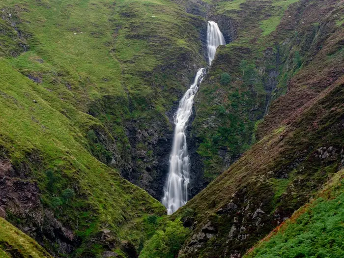
Image by Orion Media Group The Southern Upland Way is Scotland’s big southern crossing: 344 km from Portpatrick on the Irish Sea to Cockburnspath near the North Sea. It suits experienced walkers who want a quieter, rougher coast-to-coast than the better-known Highland routes.
The trail starts above Portpatrick’s old harbour, then turns inland through Dumfries & Galloway, Galloway Forest Park and the Lowther Hills. Further east it works through Ettrick country, the Tweed valley and the Lammermuir Hills before the final drop towards the coast.
This is a varied route of forest tracks, minor roads, open moorland, grassy hills, remote glens and wet, tussocky ground after rain. Its landmarks are practical as much as scenic: Sanquhar, Wanlockhead, Lowther Hill’s white radar dome, St Mary’s Loch, Melrose and the long, exposed eastern hills.
What makes the Southern Upland Way serious is not technical difficulty, but scale and spacing. Long upland days, sparse accommodation and limited resupply mean fitness, navigation, weather judgement and advance booking matter from the start.
This guide covers stages, days, accommodation, food, transport, terrain and common mistakes.
Stage-by-Stage Guide
The stages below follow a practical 12-stage west-to-east itinerary from Portpatrick to Cockburnspath. It is a demanding schedule: several days are over 30 km, and three early inland stages are around 40 km or more. Many walkers split these with wild camping, bothies or pre-arranged pick-ups, especially where accommodation and resupply are thin.
Distances are approximate. Current accommodation, bothy availability, forestry diversions and public transport should be checked before travelling.
Stage 1: Portpatrick to Castle Kennedy — 22 km
The Southern Upland Way begins at Portpatrick’s old harbour on the Irish Sea, then climbs out above the village on waymarked paths past the first short clifftop section. This opening day gives a quick change from coast to inland walking, leaving the sea behind and setting the tone for a route that soon becomes quieter and more rural.
Terrain is mixed rather than mountainous: coastal path at the start, then inland tracks, field edges, minor roads and softer ground depending on recent rain. Expect the waymarking to be useful, but do not treat the first day as a simple warm-up; the route is already moving through country where missed turns can cost time.
Castle Kennedy is the first practical stopping point on the standard itinerary. Food, water and accommodation should be planned before arrival rather than assumed on the day, as services on the route are widely spaced. If staying nearby, book ahead and check exactly how far the accommodation is from the trail.
Portpatrick has road access and is reached by bus from Stranraer, which is the nearest railway station to the start. Castle Kennedy has road access, but onward public transport options should be checked before travelling. Carry enough food and water from Portpatrick to complete the stage independently.
Navigation is generally straightforward where the thistle waymarks are present, but the change from coastal walking to inland lanes and tracks means map-and-compass or GPS backup is still important. In poor visibility or heavy rain, take extra care at junctions and field crossings.
Stage 2: Castle Kennedy to Bargrennan — 44 km
This is one of the major planning challenges of the whole route. At around 44 km, Castle Kennedy to Bargrennan is a very long day, passing through increasingly remote Dumfries & Galloway countryside with New Luce as the key named settlement between the two ends.
The walking is a mix of minor roads, tracks, open country and forestry approaches, with ground conditions becoming more committing as the route heads towards the Galloway hills. After rain, expect wet grass, mud and boggy sections, particularly away from firmer tracks.
New Luce is the main place to note for pacing and decision-making, but do not rely on finding full resupply without checking in advance. For most walkers, this stage needs either an early start, a very efficient pace, or a planned split using wild camping, bothies or transport support.
Bargrennan is a recognised trail stop, but beds are limited across this western and central part of the Way. Accommodation at or near Bargrennan should be booked well ahead. Carry enough food for the full day and have a water plan that does not depend on unverified services.
Public transport and road access are limited compared with larger trail towns. Any plan to leave or join the route here should be checked carefully before travelling. This is also the point where carrying emergency food and a flexible accommodation plan starts to matter.
Navigation can be more serious than the distance alone suggests. Forestry tracks, open sections and long gaps between settlements make it important to keep checking position, especially in poor visibility or if forestry work has affected waymarks. Diversion notices on the official trail site should be checked before setting out.
Stage 3: Bargrennan to St John’s Town of Dalry — 41 km
Bargrennan to St John’s Town of Dalry is another very long and remote stage, moving through the wild forested heart of the Galloway hills. This is some of the quietest country on the Southern Upland Way and forms part of the Galloway Forest Park area.
Expect extensive forestry, forest tracks, remote glens and stretches of rougher, wetter ground. The distance, combined with the limited places to stop, makes this a strenuous day even for fit walkers. In bad weather the stage can feel committing, with long periods away from settlements.
Galloway Forest Park is the main highlight, valued for its remoteness and dark-sky character, but that same remoteness creates the main practical difficulty. Food and water should be carried from the start unless a reliable alternative has been arranged. Natural water may be present in the wider landscape, but any plan to use it needs suitable treatment and should not replace carrying enough for the day.
St John’s Town of Dalry is the end-of-stage settlement and a key accommodation point before the route continues into another long upland leg. Accommodation should be booked in advance, and any evening food arrangements should be checked before arrival.
Road access exists at the settlement ends, but public transport options are not as convenient as the railway-served points farther east. If using luggage transfer, pick-ups or a support vehicle, confirm access arrangements directly before committing to the itinerary.
Navigation requires attention. The Southern Upland Way is waymarked, but forestry, long tracks and poor visibility can make it easy to drift onto the wrong line. Carry full mapping and do not rely on phone signal alone.
Stage 4: St John’s Town of Dalry to Sanquhar — 41 km
This is the third of the very long early-to-middle stages and should be treated as a serious hill day. The route leaves St John’s Town of Dalry and continues east through remote upland country towards Sanquhar, with long gaps between reliable services.
Terrain is typical of the Southern Uplands: rolling grassy hills, open moorland, tracks, minor roads and wet ground after rain. Although the trail is waymarked, the combination of distance, exposure and limited escape options makes this a stage for settled planning rather than improvisation.
Views open out across the Southern Uplands as the route gains higher ground, but there is also little shelter on exposed moorland sections. Wind, low cloud and prolonged rain can make progress slower than the map distance suggests.
Sanquhar is a major practical waypoint because the trail passes directly through the town and it has a railway station on the Glasgow–Kilmarnock–Dumfries–Carlisle line. It is also known for the world’s oldest working post office, operating since 1712. This is a sensible place for resupply, a rest, or a staged exit from the trail, but accommodation and services should still be booked or checked ahead.
Food and water planning should assume a long self-sufficient day from St John’s Town of Dalry to Sanquhar. If breaking the stage, wild camping or other arrangements must be planned carefully and in line with Scottish access rights.
Navigation is most important on the open moorland and in poor visibility. Keep a close watch on waymarks, bearings and position, particularly where tracks branch or the path becomes faint across wet ground.
Stage 5: Sanquhar to Wanlockhead — 13 km
This is one of the shortest stages on the 12-day itinerary, but it is not a rest-day stroll. The route climbs from Sanquhar into the Lowther Hills towards Wanlockhead, gaining height into a more exposed upland landscape.
The walking is shorter but steeper and more open than the previous day’s town finish might suggest. Ground can be wet, grassy and exposed, and weather can change quickly as the trail rises.
Wanlockhead is Scotland’s highest village, at around 467 m, and a former lead-mining settlement. Its lead-mining heritage and high-level setting make it one of the most distinctive stops on the route. The village is also associated with the country’s highest pub.
This shorter day can be useful for recovery after the long Galloway stages, or for building in time around Sanquhar’s rail access. Food, water and accommodation should still be checked in advance, as upland villages have limited capacity and services can be seasonal or reduced.
Public transport flexibility is better at the Sanquhar end because of the railway station. Wanlockhead has road access, but onward transport should be checked before relying on it.
Navigation is usually less complex than the longer remote stages, but cloud on the hills can reduce visibility quickly. Carry warm layers even in summer; the stage finishes high, and conditions in Wanlockhead can feel markedly different from Sanquhar.
Stage 6: Wanlockhead to Beattock — 32 km
This is a high, exposed and important stage, crossing the Lowther Hills and passing the highest point of the Southern Upland Way. The route reaches Lowther Hill at 725 m, marked by the white radar dome locally known as the golf ball.
Terrain is upland and weather-dependent. Expect open moorland, grassy hill tracks, exposed tops and wet sections after rain. The day is long enough to require an early start, especially if visibility is poor or wind slows progress over the higher ground.
Lowther Hill is the main landmark and one of the defining moments of the route. The radar dome is visible from far off in clear weather, but it should not replace proper navigation; cloud can remove the landmark completely.
Beattock is the end-of-stage stopping point, with Moffat nearby as an important service centre off or near the route corridor. Accommodation at Beattock or near Moffat should be arranged in advance, and any transfer between the trail and accommodation should be confirmed before walking the stage.
Food and water should be planned as for a full upland day. Do not rely on finding services between Wanlockhead and Beattock. Carry waterproofs, warm layers and spare food even if the forecast looks reasonable.
Navigation and exposure are the key warnings. The high ground around Lowther Hill is not technically difficult in normal conditions, but mist, wind and cold rain can make it serious. In winter this stage is for experienced hill walkers only.
Stage 7: Beattock to St Mary’s Loch — 34 km
Beattock to St Mary’s Loch is another long stage that moves back into quieter hill and glen country. The route heads towards the Ettrick and Yarrow landscape of the Scottish Borders, finishing beside the largest natural loch in the Borders.
Terrain is varied: upland tracks, open moorland, grassy hills, glens and some rougher ground. After wet weather, expect boggy sections and slower progress. The distance makes it a substantial day even without extreme height gain.
St Mary’s Loch is the major highlight, set in classic Borders scenery with literary links to James Hogg and Sir Walter Scott. The former Tibbie Shiel’s Inn is part of the area’s trail identity, but current services and accommodation should be checked before relying on anything at the loch.
This is a stage where end-of-day logistics need careful handling. St Mary’s Loch is not a large trail town, and accommodation can be limited. Book ahead, and confirm whether evening food is available or whether supplies need to be carried in.
Road access exists around St Mary’s Loch, but public transport should not be assumed. Any plan to join, leave or be collected here should be arranged before the walk.
Navigation remains important on the open sections before the loch. Low cloud can make broad moorland confusing, and wet ground can obscure the most obvious line. Keep checking the map rather than following every trod or track that appears to head the right way.
Stage 8: St Mary’s Loch to Traquair — 19 km
This shorter stage leaves St Mary’s Loch and continues towards Traquair, moving from loch and hill country towards the Tweed valley area. After the longer previous days, it offers a more manageable distance, though the route remains rural and upland in character.
The walking includes open hillside, tracks and valley approaches, with conditions depending heavily on recent weather. Wet ground and mud are still possible, particularly on grassy or less-used sections.
The main highlight is the transition from the remote loch setting into the Borders communities around Traquair. Traquair House, often cited as Scotland’s oldest continuously inhabited house, lies near the route area and gives this stage a strong historical focus.
Food and water should be planned before leaving St Mary’s Loch. Traquair is a small community rather than a large resupply hub, so accommodation, meals and any onward arrangements should be checked in advance. Innerleithen is nearby and may be relevant for accommodation or services, but any off-route distance and transport should be confirmed before booking.
Road access is better than on the most remote western stages, though public transport still needs checking. This can be a useful stage for adjusting the itinerary if accommodation availability around St Mary’s Loch or Traquair is tight.
Navigation is generally less severe than on the longest moorland days, but complacency is still a risk. The route crosses a mix of tracks and paths where waymarks should be followed carefully.
Stage 9: Traquair to Melrose — 29 km
This stage continues through the eastern Borders towards Melrose, with the Tweed valley becoming more central to the character of the walk. It is a moderate-to-long day by Southern Upland Way standards, but with better access to towns and services than the remote Galloway and Lowther sections.
Terrain is mixed: tracks, paths, rolling hills, minor roads and valley walking. Ground can still be muddy after rain, but the stage feels less isolated than the long western upland days.
Galashiels lies near this part of the route corridor, and Tweedbank railway station is close to the eastern half of the Southern Upland Way near Galashiels and Melrose. This makes the area one of the more useful public transport access points on the trail.
Melrose is a major overnight stop and one of the strongest cultural highlights of the route. Melrose Abbey, the ruined 12th-century Cistercian abbey traditionally associated with the heart of Robert the Bruce, is the key landmark. Accommodation demand can still be high, so booking ahead remains sensible.
Food and water are easier to plan here than on the remote middle stages, but do not leave it to chance if arriving late. Use Melrose as a practical resupply and recovery point before the Lammermuir stages begin to draw nearer.
Navigation is usually helped by more frequent settlement and track options, but that also means more junctions. Follow the waymarks carefully through the valley and town approaches rather than assuming the most obvious road or path is the trail.
Stage 10: Melrose to Lauder — 16 km
Melrose to Lauder is a shorter stage and a useful breather after the longer approach from Traquair. The route leaves the Tweed-side town and continues east through rolling Borders countryside.
The terrain is a mix of paths, tracks, field edges, minor roads and low hills. Conditions are generally less remote than the western half, but wet ground and muddy field sections can still slow progress after rain.
The main practical advantage of this stage is its manageable distance between two recognised trail towns. It can be used as a recovery day, a late-start day after resupplying in Melrose, or a way to align accommodation before the more remote Lammermuir Hills.
Lauder is the overnight stop and should be treated as a key booking point before the final eastern stages. Arrange accommodation and evening food in advance, especially in busy walking periods.
Public transport options should be checked before travelling. Melrose is near the Tweedbank rail access point, while Lauder has road access but should not be assumed to have convenient onward connections without checking current timetables.
Navigation is not the hardest on the route, but field and lane sections require attention to waymarks. Take care with any road walking or road crossings, particularly in poor visibility or at busier times of day.
Stage 11: Lauder to Longformacus — 23 km
This stage begins the final approach into the Lammermuir Hills, the last major upland block of the Southern Upland Way. It passes through quieter Borders country, with Abbey St Bathans appearing in the sequence of places before Longformacus.
Terrain becomes more open and remote again, with moorland, tracks, old farmed landscapes and valleys replacing the more settled feel around Melrose and Lauder. Underfoot conditions can be wet and tussocky, especially after rain.
The Lammermuirs are known for their windswept, lonely character, and this stage starts to feel like a return to the self-reliant walking of the western half. Views can be wide in clear weather, but shelter is limited on exposed ground.
Food and water availability should be treated cautiously. Do not assume full services at intermediate points, and check what is available at Longformacus before arrival. Accommodation is sparse, so this stage should be booked or otherwise planned well ahead.
Road access exists in the wider area, but public transport options are limited and should be checked before relying on them. If using a pick-up or off-route accommodation, confirm the meeting point carefully.
Navigation becomes more important again as the landscape opens out. Waymarks, map and GPS should be used together, particularly in mist or if forestry or land-management work has affected the signed line.
Stage 12: Longformacus to Cockburnspath — 30 km
The final stage crosses the remaining Lammermuir Hills before dropping towards Cockburnspath, where the Southern Upland Way finishes near the North Sea coast. At around 30 km, it is a full day rather than an easy finish.
Expect open moorland, remote valleys, tracks, rougher wet sections and some final coastal-edge character as the route reaches the eastern end. The Lammermuirs can be exposed to wind and poor weather, so start early and keep bad-weather alternatives realistic.
The main highlight is the completion of the coast-to-coast crossing at Cockburnspath. The change from lonely hill country to the village near the sea gives a clear sense of arrival, but the walking before that point remains serious enough to require normal hill discipline.
Food and water should be carried for the full day from Longformacus unless reliable arrangements have been made. Cockburnspath is the finish, but onward travel and any post-walk accommodation should be organised before setting off.
Cockburnspath is off the rail network. Buses run from Cockburnspath to Dunbar, on the East Coast Main Line for Edinburgh, and to Berwick-upon-Tweed for England, but current timetables should be checked before travelling. Returning from the finish to the start at Portpatrick is essentially a full day on public transport.
Navigation should not be relaxed just because it is the last day. The Lammermuir Hills are broad and exposed, and poor visibility can make the line difficult across open ground. Check the official trail site for any forestry or route diversions before the final stage.
Recommended Itinerary
The Southern Upland Way is often planned as a 12-stage walk, but that is a demanding schedule. Several days exceed 30 km, and three early stages are around 40 km or more, so most walkers should treat the table below as a booking framework rather than a fixed prescription.
Distances are approximate. Check official mapping before booking accommodation, especially if using off-route accommodation, vehicle pick-ups, bothies or wild-camping stops.
Standard 12-day itinerary
| Day | From | To | Approx. distance | Why this stage makes sense | Services/accommodation notes |
|---|---|---|---|---|---|
| 1 | Portpatrick | Castle Kennedy | 22 km | A sensible first day from the official harbour start, with an early coastal section before the route turns inland. It gives time to arrive in Portpatrick the previous day and begin without immediately committing to a huge mileage. | Portpatrick is off the rail network; most walkers arrive via Stranraer and local bus. Castle Kennedy is a practical first stopping point, but accommodation should be booked ahead. |
| 2 | Castle Kennedy | Bargrennan | 44 km | This is the first major test of the route: a very long west-to-east crossing through increasingly quiet country. It is a logical stage on a 12-day schedule, but it is too long for many walkers carrying full camping kit. | This is one of the key stages to split if walking a slower itinerary. New Luce lies between Castle Kennedy and Bargrennan, but any overnight plan here should be checked before travelling. |
| 3 | Bargrennan | St John's Town of Dalry | 41 km | A long, remote Galloway day through forest and upland country. It keeps the west section moving, but requires an early start, efficient navigation and a realistic view of pace on wet ground. | Beds are sparse on this part of the route. Bothies and wild camping may help break the distance, but availability and suitability should be checked before travelling. |
| 4 | St John's Town of Dalry | Sanquhar | 41 km | Another very long upland stage, linking two of the main trail settlements before the Lowther Hills. This is one of the toughest scheduling days on the whole Way. | Sanquhar is a useful trail town and has a railway station on the Glasgow–Kilmarnock–Dumfries–Carlisle line, making it a practical point for joining, leaving or taking a rest. Book accommodation well ahead. |
| 5 | Sanquhar | Wanlockhead | 13 km | A deliberately short day after three hard stages. It allows recovery before the higher Lowther Hills and gives time to deal with laundry, food and weather delays if services are available. | Wanlockhead is Scotland's highest village and a logical overnight before the high ground around Lowther Hill. Accommodation is limited; confirm current options before relying on them. |
| 6 | Wanlockhead | Beattock | 32 km | A serious upland day over the Lowther Hills, including the highest point of the trail on Lowther Hill. The shorter previous day helps make this stage more manageable. | Beattock is the practical stopping point on the route. Moffat is nearby, but any transfer or off-route accommodation arrangement should be organised in advance. |
| 7 | Beattock | St Mary's Loch | 34 km | A long transition into classic Ettrick and Yarrow country, finishing at one of the most recognisable natural landmarks on the route. It is a big day but avoids leaving an awkwardly isolated stop. | Accommodation around St Mary's Loch is limited and should be booked early. If relying on camping or pick-up, check the exact overnight plan before committing to the mileage. |
| 8 | St Mary's Loch | Traquair | 19 km | A shorter, more forgiving stage after the Beattock–St Mary's Loch crossing. It gives time to manage wet ground, slower going and any logistical detours around accommodation. | Traquair is a small Borders community; nearby accommodation options may require planning. Do not assume same-day availability. |
| 9 | Traquair | Melrose | 29 km | A substantial but normal-length day into the Tweed valley and one of the best service hubs on the eastern half of the route. It is a useful point to reset before the Lammermuir Hills. | Innerleithen and Galashiels are nearby to this section, and Tweedbank station is close to the eastern half of the trail. Melrose is the natural overnight hub here, but accommodation still needs booking. |
| 10 | Melrose | Lauder | 16 km | A short stage that works well after the longer approach to Melrose and before the more exposed final hills. It also gives time for resupply or a later start if needed. | Melrose and Lauder are among the more practical overnight stops in the Borders section. This is a useful place in the itinerary to absorb delays. |
| 11 | Lauder | Longformacus | 23 km | A moderate-distance day that leads towards the Lammermuir Hills without forcing the final 30 km finish too soon. | Accommodation is sparse again. Longformacus should be treated as a pre-booked stop, not a place to arrive and improvise. |
| 12 | Longformacus | Cockburnspath | 30 km | A fitting final stage across the lonely Lammermuir country before dropping to the eastern terminus at Cockburnspath. It is long enough to require a proper hill-day mindset even though it is the finish. | Cockburnspath is off the rail network. Buses run to Dunbar for the East Coast Main Line and to Berwick-upon-Tweed, but current timetables should be checked before travelling. |
Slower variant: 13–16 days
A 13–16 day schedule is more realistic for many independent walkers, especially those carrying camping kit or wanting a margin for poor weather. The best places to add time are the very long early and middle stages: Castle Kennedy–Bargrennan, Bargrennan–St John's Town of Dalry, St John's Town of Dalry–Sanquhar, Beattock–St Mary's Loch and Longformacus–Cockburnspath.
This slower version usually depends on one or more of the following:
- wild camping under Scottish access rights;
- using bothies as wet-weather shelters where appropriate;
- arranging vehicle pick-ups or off-route accommodation;
- taking a rest or half-day around Sanquhar, Wanlockhead, Melrose or another practical hub.
Do not split stages on the assumption that services exist at convenient intervals. The Southern Upland Way has long gaps between settlements, so any shorter itinerary needs accommodation, camping spots, transport links and current forestry diversions checked before booking.
Faster variant: 12 days or less
The 12-day itinerary above is already the fast end of a normal Southern Upland Way schedule. It suits fit, experienced hill walkers who are comfortable with repeated 30–40 km days, wet moorland, exposed uplands and limited facilities.
Compressing the route below 12 days is not recommended for most walkers. It would require combining already long stages, carrying enough food between sparse resupply points, and accepting very little margin for bad weather, slow boggy ground or transport delays. Exact distances and overnight options should be checked against official mapping before booking.
Planning the Route
The central planning problem on the Southern Upland Way is not finding the line of the path; it is making the distances, beds, food and transport work across a very empty part of Scotland. The waymarking is generally good, but several stages cross exposed upland, forestry and boggy moorland where bad weather can turn a long day into a serious navigation exercise.
Most walkers should allow 12–16 days. A 12-day schedule is possible, but it is a hard itinerary with several very long days, including consecutive 40 km-plus sections in the west and south-west. For most independent walkers, 14–16 days is the more forgiving plan, especially if carrying camping kit, waiting out weather, or relying on public transport at either end.
Choosing an itinerary
The route is usually planned west-to-east from Portpatrick to Cockburnspath, following the official direction from the Irish Sea to the North Sea. Daily stages are strongly shaped by the limited settlement pattern: there are obvious hubs such as Bargrennan, St John’s Town of Dalry, Sanquhar, Wanlockhead, Beattock, Melrose, Lauder and Longformacus, but the spaces between them can be large.
A common 12-stage schedule works on paper, but it should not be treated as a comfortable default. The most demanding planning pinch points are the western and central sections where accommodation, food and public transport are thin.
| Section | Planning issue |
|---|---|
| Castle Kennedy to Bargrennan | A very long stage at about 44 km; many walkers will want to break it by camping or arranging support. |
| Bargrennan to St John’s Town of Dalry | Another long upland/forest day at about 41 km, with limited options once committed. |
| St John’s Town of Dalry to Sanquhar | Around 41 km and remote in character; plan food, water and weather carefully. |
| Wanlockhead to Beattock | Crosses the Lowther Hills and the high point at Lowther Hill; exposure and navigation matter more than the distance alone. |
| Beattock to St Mary’s Loch | A long stage at about 34 km with limited facilities en route. |
| Lauder to Cockburnspath | The final Lammermuir stages are lonely and should not be underestimated, especially in poor visibility or strong wind. |
If walking the Way in 13–16 days, the extra time is best used to split the longest western and central days rather than simply adding rest days in larger towns. Wild camping under Scottish access rights and the route’s bothies can help fill the gaps, but bothy availability and current condition should be checked before travelling.
Fast, steady or slower?
A fast traverse suits very fit walkers who are comfortable with 30–40 km days, carrying enough food, and navigating in poor upland weather. It leaves little margin for boggy ground, forestry diversions, missed buses or a full day of rain.
A steadier schedule is usually more practical. The ground can be wet and tussocky after rain, and progress on open moorland is often slower than the map distance suggests. Adding two or three days gives more flexibility around accommodation and reduces the pressure to push on late in the day.
A deliberately slow itinerary is possible, but not always easy to book because the settlements are not evenly spaced. Shortening every day into neat half-stages may require camping, vehicle pick-ups, taxis or off-route accommodation. This should be checked before travelling.
Accommodation drives the schedule
Accommodation should be planned before travel, not improvised day by day. Beds are sparse on the long middle stages, and some places have only a small number of rooms. Booking well ahead is the safest approach if relying on B&Bs, guesthouses, inns or hostels.
Camping gives much more control over the route. It is especially useful for breaking the long 40 km-plus stages between Castle Kennedy, Bargrennan, St John’s Town of Dalry and Sanquhar. Even with camping kit, do not assume that every planned stopping point will be ideal in bad weather; arrive with enough daylight to choose a sensible pitch.
Bothies should be treated as useful shelters rather than guaranteed accommodation. They are basic, may already be occupied, and should not be the only plan for a critical night unless current access and condition have been checked.
Food, water and resupply
Food planning is as important as accommodation planning. Do not assume there will be shops, cafés or evening meals between the named settlements. On the long upland and forestry sections, carry enough food for the full day plus a reserve.
Resupply is easiest around the larger trail towns and transport-linked places such as Sanquhar, Melrose and nearby Galashiels, but exact shop opening hours and meal availability should be checked before travelling. This matters particularly if arriving late after a long stage.
Water should be planned for each day rather than left to chance. Carry enough to cover dry or exposed sections, and treat any water taken from natural sources. In warm weather, the long moorland stages can be more committing than their altitude suggests.
Navigation and route information
The Southern Upland Way is waymarked with the thistle symbol, but it is not a route to walk on waymarks alone. Open moorland, forestry tracks, boggy ground and poor visibility can make navigation demanding, particularly in the Galloway hills, the Lowther Hills and the Lammermuir Hills.
Carry proper mapping for the whole route, with OS Explorer maps or equivalent, plus a guidebook or reliable route notes. A GPS device or phone mapping is useful, but it should not be the only navigation method on exposed stages. Batteries, weather and forestry work can all affect how straightforward the day feels.
Forestry diversions can occur, especially on sections using forest tracks and plantations. The official Southern Upland Way site should be checked for current diversion notices before setting off.
Transport and section hiking
Transport needs planning at both ends because neither terminus is on the rail network. For the start, the practical approach is rail to Stranraer and then a local bus to Portpatrick. At the finish, Cockburnspath has buses towards Dunbar and Berwick-upon-Tweed for onward rail connections.
End-to-end travel back to the start is slow and can take most of a day. If driving, think carefully about where the vehicle will be left and how the return journey will work; public transport between the two ends is not a quick shuttle.
Section hiking is practical, but it works best when planned around the few useful transport breaks. Sanquhar is the key mid-route railway station, and Tweedbank near Galashiels and Melrose is useful for the eastern half. Other access points may require buses, taxis or lifts, and current timetables should be checked via Traveline Scotland before booking accommodation.
Weather and timing
The best planning window is roughly April to October, with late spring and early autumn often giving a good balance of daylight, ground conditions and fewer midges. Summer gives long days, which helps on the 30–40 km stages, but it does not remove the need for waterproofs, warm layers and proper navigation.
Winter is a very different undertaking and is suitable only for experienced hill walkers. The route crosses high, exposed ground, including the Lowther Hills and Lowther Hill at 725 m, where wind, cold, snow or poor visibility can make progress slow and serious.
Build flexibility into the plan wherever possible. On this route, the most useful buffer is not a sightseeing rest day; it is a spare margin for weather, a missed connection, a full accommodation problem, or a long moorland stage that takes longer than expected.
Towns, Villages and Overnight Stops
Accommodation and resupply are the main constraint on the Southern Upland Way. The named stops below follow the west-to-east order of the trail, but several gaps between them are long and exposed, especially across Galloway, the Lowther Hills and the Lammermuirs.
Book beds well ahead, particularly if walking without a tent. In the smaller villages, do not assume an evening meal, breakfast, packed lunch or shop will be available every day; opening hours and accommodation availability should be checked before travelling.
Portpatrick
Portpatrick is the western trailhead, with the official start at the old harbour on the Irish Sea coast. It is the natural place to stay the night before beginning, especially if arriving by public transport and wanting an early start.
The village is useful because the route climbs out from here immediately past the clifftops before turning inland. Accommodation and food options should be booked in advance, as onward accommodation gaps begin quickly once the walk leaves the coast.
Portpatrick is off the rail network. The usual public-transport approach is by train to Stranraer, then local bus for the short onward journey to Portpatrick; current bus times should be checked before travelling.
Stranraer
Stranraer is not on the Southern Upland Way itself, but it is the key access town for the start. It has the nearest railway station to Portpatrick, with services from Glasgow via Kilmarnock and Ayr.
For walkers travelling a long distance to the west coast, Stranraer can be a practical pre-walk overnight stop if Portpatrick accommodation is full or if train and bus connections do not line up cleanly. Allow time for the final bus transfer to Portpatrick before starting the trail.
Castle Kennedy
Castle Kennedy is the first common overnight stop on a 12-stage itinerary, about 22 km from Portpatrick. It is a useful first target because it breaks the opening west-coast approach before the route commits to longer inland stages.
Facilities are much more limited than in a larger town, so accommodation and meals should be arranged before arrival. If planning to continue beyond Castle Kennedy, carry enough food and water capacity for the long next leg towards Bargrennan.
There is no rail station on the trail here. Any local bus or taxi options should be checked before relying on them.
New Luce
New Luce sits in the early western part of the route between Castle Kennedy and Bargrennan. It can be useful for walkers looking to break up the very long Castle Kennedy–Bargrennan stage, which is around 44 km in the standard 12-stage schedule.
Treat New Luce as a potential planning point rather than a guaranteed full-service stop. Accommodation, food and transport options should be checked before travelling, and walkers using it to shorten the day should make firm arrangements in advance.
Bargrennan
Bargrennan is one of the key western overnight stops, reached after the long stage from Castle Kennedy in the common itinerary. It sits at the edge of the remote Galloway section, where the route begins to feel significantly more isolated.
This is a practical place to sleep, eat and reset before the long onward stage to St John's Town of Dalry. Beds are limited, so book early; if accommodation is unavailable, walkers often need to think in terms of camping, bothies or arranged pick-ups.
Do not leave Bargrennan assuming frequent services ahead. Carry sufficient food for the next remote section and check any accommodation, bothy and forestry diversion information before setting off.
St John's Town of Dalry
St John's Town of Dalry is a major planning stop in the western half of the Southern Upland Way. It is commonly used as the overnight after Bargrennan, following another long upland day of around 41 km in the 12-stage itinerary.
The village gives walkers a valuable chance to recover, dry kit and prepare for the next long leg to Sanquhar. Accommodation should be booked in advance, and meal arrangements should be checked rather than left to chance.
This is also a sensible point to reassess pace. The sequence from Castle Kennedy through Bargrennan and Dalry to Sanquhar is demanding, with several stages around 40 km or more if walked on the fastest common schedule.
Sanquhar
Sanquhar is one of the most important service points on the route. The Southern Upland Way passes directly through the town, and it also has a railway station on the Glasgow–Kilmarnock–Dumfries–Carlisle line.
It works well as an overnight stop, a resupply point and a place to join or leave the trail. For section-hikers, Sanquhar is one of the easiest mid-route access points on the whole walk.
Sanquhar is also known for having the world's oldest working post office, operating since 1712. Practicalities matter more than sightseeing here: use the town to restock, check onward weather and prepare for the climb into the Lowther Hills and Wanlockhead.
Wanlockhead
Wanlockhead is a short stage from Sanquhar in the 12-stage itinerary, around 13 km, but it is a significant overnight stop because of its height and position before the Lowther Hills. At around 467 m, it is Scotland's highest village.
Accommodation is limited and should be booked ahead. The village has a strong lead-mining history, a lead-mining museum and the country's highest pub, making it one of the more distinctive stops on the trail.
Do not underestimate the next section despite the shorter approach into Wanlockhead. The route crosses the highest ground of the Southern Upland Way near Lowther Hill, topped by the white radar dome known locally as “the golf ball”. Weather can be exposed, and leaving with food, water and full waterproofs is essential.
Beattock
Beattock is the next main overnight stop after Wanlockhead, reached after a long stage of around 32 km in the common itinerary. It marks a useful transition point after the Lowther Hills before the route continues east towards the Ettrick and Yarrow country.
Accommodation and food should be arranged before arrival. If using nearby services away from the trail corridor, onward transfers should be planned rather than improvised at the end of a long day.
Moffat
Moffat is near the route rather than a standard on-trail stage endpoint in the itinerary. It can be useful if Beattock-area accommodation is full, or if a walker wants a larger nearby base for a rest, resupply or rearranging transport.
Because it is off the main walking line, any detour, taxi or bus link should be planned in advance. This should be checked before travelling, especially if using Moffat as a substitute overnight stop during a tight itinerary.
St Mary's Loch
St Mary's Loch is a key overnight area in the middle-eastern section, reached after the long Beattock stage of around 34 km. It is the largest natural loch in the Scottish Borders and sits in classic Ettrick and Yarrow country.
This is a scenic but sparse stop, not a full-service town. Accommodation and meals need advance planning, and walkers should not rely on flexible late-evening options after a long day.
St Mary's Loch is also a useful place to pause before the shorter onward stage to Traquair. The former Tibbie Shiel's Inn is part of the loch's trail lore, but current facilities and opening arrangements should be checked before travelling.
Traquair
Traquair is a small Borders community used as the overnight stop after St Mary's Loch in the common itinerary. The stage into Traquair is around 19 km, making it a noticeably shorter day than many of the western and central sections.
Facilities are limited, so accommodation and food should be secured in advance. The area is close to Traquair House, often cited as Scotland's oldest continuously inhabited house, but walkers should prioritise practical arrangements over assuming visitor facilities will suit trail timings.
Traquair also positions walkers for the next longer stage towards Melrose, passing near Innerleithen and the Tweed valley.
Innerleithen
Innerleithen is near the route rather than the main overnight stop in the standard stage list. It can be useful for accommodation, food or transport flexibility when planning the Traquair to Melrose section.
Any use of Innerleithen as an overnight base should be planned carefully, as it may involve leaving or rejoining the waymarked trail. Local bus and taxi options should be checked before travelling.
Galashiels
Galashiels is another near-route service town in the eastern half rather than a standard overnight stage in the itinerary. Its main value for Southern Upland Way walkers is transport and access to services in the Tweed valley area.
The Borders Railway terminus at Tweedbank, near Galashiels and Melrose, is one of the most useful rail access points for the eastern half of the trail. It can be used for joining, leaving or splitting the route, but connections from the trail should be planned in advance.
Melrose
Melrose is one of the best and most useful overnight towns on the route. It sits on the Tweed-side section and is a common stop after Traquair, with a stage of around 29 km in the 12-stage schedule.
This is a good place for a proper reset: accommodation, meals and resupply are generally more realistic here than in the smaller upland settlements, though individual opening hours and availability still need checking. It is also close to the Tweedbank railhead, making it useful for section-hikers.
Melrose Abbey is the main local landmark, a ruined 12th-century Cistercian abbey traditionally associated with the heart of Robert the Bruce. For planning purposes, Melrose is also the last notably larger trail town before the route heads through smaller Borders settlements and the Lammermuir Hills.
Lauder
Lauder is the next main overnight stop after Melrose, reached after a shorter stage of around 16 km in the common itinerary. It is a practical place to stay before the final, more remote eastern stages begin to build.
Book accommodation ahead and check meal options, especially outside peak season or on quieter weekdays. The shorter distance from Melrose can make Lauder a useful half-recovery day before continuing to Longformacus.
Abbey St Bathans
Abbey St Bathans lies in the eastern section before Longformacus and Cockburnspath. It is not listed as a standard overnight endpoint in the 12-stage itinerary, but it is an important named place on the approach into the Lammermuirs.
Use it as a potential planning reference rather than assuming full services. Accommodation, food and onward transport should be checked before travelling if building a shorter or more flexible itinerary around this area.
Longformacus
Longformacus is the final main overnight stop before Cockburnspath in the standard itinerary, reached from Lauder after around 23 km. It is a crucial staging point because the final day to the east coast is around 30 km and crosses lonely Lammermuir country.
Facilities are limited, so beds and meals should be arranged well in advance. Walkers should leave Longformacus prepared for a full upland day, with food, water, waterproofs and navigation ready before setting out.
This is not a place to rely on last-minute logistics. If no accommodation is available, alternatives such as camping or pre-arranged pick-up need to be organised before the walk begins.
Cockburnspath
Cockburnspath is the eastern terminus of the Southern Upland Way, where the route finishes near the North Sea coast. It is the completion point after the final Longformacus stage across the Lammermuir Hills.
Some walkers stay locally after finishing, while others leave the same day by bus. Cockburnspath is off the rail network, but buses connect with Dunbar on the East Coast Main Line for Edinburgh and with Berwick-upon-Tweed for onward travel into England.
Do not assume a quick end-to-end return to the start. Travelling from Cockburnspath back to Portpatrick is effectively a full day on public transport, and current bus and rail times should be checked before travelling.
Getting to the Start
The Southern Upland Way starts at the old harbour in Portpatrick, on the Irish Sea coast. Portpatrick is not on the rail network, so most walkers reach it via Stranraer, then use a local bus or taxi for the final few miles.
By train
The nearest railway station for the start is Stranraer. There are direct train services from Glasgow via Kilmarnock and Ayr, making Glasgow the usual rail gateway for walkers coming from elsewhere in Scotland or from long-distance UK rail connections.
From Stranraer, continue to Portpatrick by local bus or taxi. Allow enough margin between the train and onward connection, especially if arriving late in the day; missing the final local link can be awkward before a long first walking day.
Current train times, engineering works and connections should be checked before travelling.
By bus
A local bus links Stranraer with Portpatrick and is described as running roughly hourly. This is the standard public-transport connection for the final approach to the trailhead.
Bus route numbers, evening services, Sunday services and seasonal timetable changes should be checked with Traveline Scotland before travelling. If the bus timing does not work with the train arrival, pre-booking a taxi from Stranraer is the sensible fallback.
By car
Driving to Portpatrick is straightforward in principle, but it creates the main problem of any coast-to-coast walk: the route finishes at Cockburnspath, far away on the east side of southern Scotland. Returning from Cockburnspath to Portpatrick by public transport is essentially a full-day journey, so leaving a car at the start is rarely the cleanest option unless a lift, car shuffle or taxi arrangement has been planned in advance.
Do not assume that convenient long-stay parking is available at or near the harbour. Long-stay parking arrangements in Portpatrick should be checked before travelling, ideally with accommodation providers or the relevant local authority.
From the nearest airport
There is no airport at the start, and Portpatrick still requires the same final approach via Stranraer. For most flight arrivals, the practical plan is to reach Glasgow, take the train towards Stranraer via Kilmarnock and Ayr, then continue by bus or taxi to Portpatrick.
Airport-to-rail transfers and same-day connections to Portpatrick should be checked carefully before booking flights. A late flight arrival may make an overnight stop in Glasgow, Stranraer or Portpatrick more realistic than trying to reach the harbour the same day.
Where to stay before starting
The most convenient pre-walk base is Portpatrick, as the official start is at the old harbour and the waymarks climb out of the village past the clifftops. Staying there avoids needing a morning transfer before the first stage.
Stranraer is the practical alternative if arriving by train late, or if Portpatrick accommodation is unavailable. From Stranraer, take the morning bus or a pre-booked taxi to Portpatrick before starting.
Accommodation should be booked ahead, especially if starting in the main walking season. The Southern Upland Way has sparse accommodation later on the route, so it is worth finalising the first few nights before setting off rather than treating the start as a flexible arrival point.
Getting Home from the Finish
Cockburnspath is not on the rail network, so the finish needs a final bus or pre-arranged road transfer before you can connect with mainline transport. Build slack into the last day: the final stage from Longformacus is long, exposed and remote, and arriving after the last useful bus can turn a successful finish into an awkward logistical problem.
By train
The nearest practical rail connections are reached by bus from Cockburnspath:
| Rail connection | How it fits the finish |
|---|---|
| Dunbar | On the East Coast Main Line, useful for Edinburgh and onward Scottish connections. |
| Berwick-upon-Tweed | Useful for onward travel into England. |
Both options require a bus or taxi from Cockburnspath first. Train times, bus connections and the best station for your onward journey should be checked before travelling, especially if finishing on a Sunday, public holiday or late in the day.
Returning from Cockburnspath to Portpatrick by public transport is a major cross-country journey rather than a quick transfer. Expect it to take most of a day, using a combination of bus, mainline rail and onward local transport at the western end.
By bus
Cockburnspath has bus links to Dunbar and to Berwick-upon-Tweed. These are the key onward routes for walkers finishing the Southern Upland Way.
Do not assume late-evening frequency. Check current bus times with Traveline Scotland before fixing the final walking day, and leave a buffer for slow going over the Lammermuir Hills, poor weather, tired legs or navigation delays.
If the last bus connection is missed, the practical fallback is a pre-booked taxi or an overnight stay. This should be planned in advance rather than left until arrival in Cockburnspath.
By car/taxi
If being collected, Cockburnspath is the obvious pick-up point, but agree the exact meeting place in advance and allow for variable finish times. Mobile signal and weather can make last-minute coordination unreliable on the final approach.
Taxis should be booked ahead, particularly for evening arrivals or if connecting to a train at Dunbar or Berwick-upon-Tweed. Availability, fares and pick-up arrangements should be checked before travelling.
Leaving a car at the finish can simplify the end of the walk, but it creates a separate start-line problem because Portpatrick is at the opposite side of southern Scotland. If a car is left at the start instead, the return from Cockburnspath to Portpatrick is effectively a full day on public transport.
From the nearest airport
For flights after the walk, first leave Cockburnspath by bus or taxi to a rail connection. Dunbar gives access towards Edinburgh, while Berwick-upon-Tweed is useful for onward routes into England.
Airport choice depends on the wider travel plan, so do not plan the flight around Cockburnspath alone. Allow generous transfer time from the finish, and check bus, train and airport-connection times before booking a same-day flight.
Where to stay at the finish
Cockburnspath is a small finish village, not a large transport hub. If the final stage is likely to finish late, or if onward buses do not line up cleanly with trains, staying overnight at or near the finish is often the safer plan.
Accommodation at the eastern end should be booked ahead, as beds on and near the Southern Upland Way can be sparse. If nothing suitable is available in Cockburnspath, plan a bus or taxi transfer towards Dunbar or Berwick-upon-Tweed and stay there before travelling on the next day. This should be checked before travelling.
Which Direction Should You Walk?
The Southern Upland Way is set up as a west-to-east route: Portpatrick on the Irish Sea to Cockburnspath near the North Sea. That is the standard direction and the one that matches the official start and finish, the usual town sequence and the common stage planning pattern.
Walking east-to-west is perfectly possible in principle, but it is the reverse of the normal flow. It does not remove the main challenges of the route: long upland stages, exposed moorland, wet ground after rain and sparse accommodation.
West to east: Portpatrick to Cockburnspath
This is the best default choice for most walkers. It gives a clean coast-to-coast progression from Portpatrick harbour, over the Galloway hills and Galloway Forest Park, through the Lowther Hills and the Borders, then across the Lammermuir Hills to the eastern finish at Cockburnspath.
Transport also works sensibly in this direction. Portpatrick is reached by train to Stranraer, then a local bus for the final few miles. At the finish, Cockburnspath has bus links to Dunbar on the East Coast Main Line for Edinburgh, and to Berwick-upon-Tweed for onward travel into England.
The scenery builds in a logical way. The route starts with a short coastal section above Portpatrick, turns into increasingly remote Galloway country, reaches its highest ground around Lowther Hill, then moves through St Mary’s Loch, Traquair, Melrose and the Lammermuirs before dropping towards the eastern coast.
Accommodation planning is also simplest west-to-east because the usual itineraries and stage order follow this direction: Portpatrick, Castle Kennedy, Bargrennan, St John’s Town of Dalry, Sanquhar, Wanlockhead, Beattock, St Mary’s Loch, Traquair, Melrose, Lauder, Longformacus and Cockburnspath. The hard parts remain the same — especially the long middle stages — but bookings and contingency planning are easier when following the standard sequence.
East to west: Cockburnspath to Portpatrick
The reverse direction can work for experienced walkers who have a specific reason to finish on the west coast, or whose transport and accommodation bookings line up better that way. It gives a strong final arrival into Portpatrick, with the old harbour making a more characterful endpoint than many inland trail finishes.
However, reverse walkers start almost immediately with the Lammermuir Hills and then work back through the Borders before reaching the Lowther and Galloway sections later in the walk. That means some of the most remote and logistically awkward country still comes after several hard days, rather than being dealt with in the first half of a standard west-to-east crossing.
Transport is workable but less neat for many itineraries. Starting at Cockburnspath means using buses from Dunbar or Berwick-upon-Tweed, while finishing at Portpatrick means leaving by local bus to Stranraer and then train onward. Current bus times should be checked before travelling, whichever direction is chosen.
Is one direction easier underfoot?
There is no decisive easy direction. The Southern Upland Way crosses a series of upland blocks rather than following one continuous ridge, so the total ascent, exposed ground and long distances are substantial either way.
The biggest difficulty is not a single climb but the spacing of services and the length of the remote stages. In either direction, the sections around Galloway, the Lowther Hills and the Lammermuirs need proper navigation, food planning and weather awareness.
Wind and weather should not be the main reason for choosing direction. The route is exposed across open moorland and hill country, and conditions can be demanding in either direction. Check the forecast carefully before committing to the longer upland days.
Recommendation
Walk west to east unless there is a clear reason not to. Portpatrick to Cockburnspath is the official and standard direction, fits the usual accommodation sequence, gives the most natural coast-to-coast progression, and leaves practical onward transport from the east coast via Dunbar or Berwick-upon-Tweed.
Choose east to west only if accommodation availability, personal travel plans or the appeal of finishing at Portpatrick outweigh the convenience of the normal direction.
Accommodation Along the Route
Accommodation is the main planning constraint on the Southern Upland Way. The route crosses long stretches of sparsely populated upland country, and several natural walking days are much longer than many hikers will want to cover between fixed beds.
A pure B&B/inn-to-inn itinerary is possible for strong walkers, but it is not as simple as on busier UK National Trails. Most hikers either book every bed well ahead, carry camping kit for the awkward gaps, or use pre-arranged lifts/taxi transfers from off-route accommodation on the longest middle stages.
How to plan overnights
The easiest overnight hubs are the larger trail settlements and nearby service towns: Portpatrick, Sanquhar, Melrose and nearby places such as Stranraer, Moffat and Galashiels. These are the places most likely to offer a practical choice of beds, food and transport links.
The hardest accommodation sections are in the western and central uplands, particularly around the long stages between Castle Kennedy, Bargrennan, St John's Town of Dalry and Sanquhar. The standard 12-stage itinerary includes several 40 km+ days, so many walkers break these with wild camping, bothies or pre-arranged pick-ups.
Beds should be booked before committing to travel dates. This is especially important if walking at weekends, during public holidays, or in the main April–October season, when one full B&B or closed inn can force a major itinerary change.
Accommodation by place
| Place | Accommodation level | Best for | Notes |
|---|---|---|---|
| Portpatrick | Good | Start night | Sensible place to stay before setting off from the official harbour start. Stranraer is nearby for rail access if Portpatrick beds are full. |
| Stranraer | Good | Transport access / overflow | Off-route but useful for arrivals by train before transferring to Portpatrick. Also a fallback if start-point accommodation is tight. |
| Castle Kennedy | Limited | First-stage stop | A practical stop on the common 12-stage schedule, but do not assume many bed options. Book before fixing the first two days. |
| New Luce | Limited | Breaking the west section | Useful only if it fits the chosen itinerary. Accommodation and services should be checked before travelling. |
| Bargrennan | Limited | Western upland stop | Important for breaking the long Castle Kennedy–Bargrennan and Bargrennan–St John's Town of Dalry stretch. Beds are thin, so have a backup plan. |
| St John's Town of Dalry | Limited | Galloway stop | A key overnight point before the long stage to Sanquhar. Book early or plan a camping/bothy alternative. |
| Sanquhar | Good | Mid-route reset / transport | One of the more useful trail towns, with a railway station on the Glasgow–Kilmarnock–Dumfries–Carlisle line. Good place to resupply, join, leave or take a shorter day onward to Wanlockhead. |
| Wanlockhead | Limited | High-level stop before the Lowther Hills | A strategically useful overnight before or after Lowther Hill. Accommodation is limited and exposed-weather contingencies matter here. |
| Beattock | Limited | Southern upland crossing stop | Works as a staging point between Wanlockhead and St Mary's Loch. Nearby Moffat may be useful for extra accommodation choice. |
| Moffat | Good | Off-route bed base / rest option | Near the route rather than on the line of the Way. Useful if arranging transfers or if Beattock options are full. |
| St Mary's Loch | Limited | Remote lochside stop | A valuable overnight location on a long and exposed part of the route. Availability should be checked early. |
| Traquair | Limited | Tweed valley approach | Useful for splitting St Mary's Loch to Melrose. Innerleithen is nearby if using off-route accommodation or transfers. |
| Innerleithen | Limited | Off-route/near-route option | Near the trail and may help with accommodation planning around Traquair and the Tweed valley. This should be checked before travelling. |
| Galashiels | Good | Transport / overflow | Near the eastern half and close to Tweedbank rail access. Useful for joining/leaving the trail or solving accommodation pressure around the Borders section. |
| Melrose | Good | Comfortable town stop / rest day | One of the strongest overnight hubs on the route and a good place to reset before the Lammermuir stages. |
| Lauder | Limited | Borders stage stop | A practical overnight between Melrose and Longformacus, but choice is not comparable with larger towns. Book ahead. |
| Abbey St Bathans | Limited | Alternative eastern stop | Can help shorten or reshape the Lauder–Longformacus–Cockburnspath end of the walk. Availability should be checked before relying on it. |
| Longformacus | Limited | Final upland stop | Important for the last stage to Cockburnspath. Beds are sparse, so confirm arrangements early. |
| Cockburnspath | Limited | Finish night / exit logistics | The official finish is in the village. Many walkers leave by bus towards Dunbar or Berwick-upon-Tweed rather than relying on a wide choice of local beds. |
Camping, bothies and long gaps
Wild camping is a practical and often necessary tool on the Southern Upland Way, particularly for walkers who do not want repeated 40 km days. Scottish access rights make lightweight camping a realistic way to manage the remote sections, provided it is done responsibly and away from buildings, livestock and enclosed ground.
There are around five bothies along the route, but they should be treated as basic shelters rather than guaranteed accommodation. They may be full, closed, unsuitable, or poorly positioned for the day’s plan. Bothy availability should be checked before travelling, and anyone relying on them should still carry a proper shelter.
Camping also gives useful flexibility if weather, boggy ground or navigation slows progress. This is particularly valuable through Galloway Forest Park, the Lowther Hills and the Lammermuir Hills, where exposed conditions can make a planned long day feel much harder than the map distance suggests.
Using taxis, transfers and off-route beds
Taxi or vehicle transfers can make the Southern Upland Way much easier for walkers who prefer beds every night. They are most useful where the trail passes near, but not directly through, larger service places such as Stranraer, Moffat, Galashiels and the Tweedbank/Melrose area.
Do not rely on last-minute lifts in the remote middle of the route. If using off-route accommodation, arrange pick-up points and times before setting out each morning, and make sure the provider understands that phone signal and arrival times may be unreliable on exposed upland stages.
Luggage transfer may be possible through specialist walking-holiday providers or local arrangements, but it should not be assumed for every overnight stop. Confirm current availability, baggage limits and exact collection points before booking a non-camping itinerary.
Is the route suitable for inn-to-inn walkers?
Yes, but only with careful planning and realistic daily distances. A strong walker can link the main accommodation hubs, but the result may involve several long days, limited fallback options and occasional off-route transfers.
For most independent hikers, the safest plan is a hybrid: book fixed accommodation in the stronger towns, carry enough kit to camp if a remote gap is too long, and treat bothies as useful shelter rather than the foundation of the itinerary.
Camping and Wild Camping
Camping is one of the most practical ways to complete the Southern Upland Way, especially on the long middle stages where accommodation and resupply are sparse. The route is well suited to experienced backpackers who can carry a tent, food and wet-weather hill kit, but it is not a casual campsite-to-campsite trail with services at predictable intervals.
Formal campsites
Formal campsite options exist in some parts of southern Scotland, but they are limited and unevenly spaced along this route. Do not assume there will be a campsite at the end of each stage, particularly across the Galloway hills, the Lowther Hills, the Ettrick country and the Lammermuir Hills.
Where a booked bed is not available, many walkers combine occasional hostels, B&Bs or inns with wild camping. Current campsite locations, opening dates and whether tents are accepted should be checked before travelling, as rural sites may be seasonal or require advance booking.
Wild camping in Scotland
Wild camping is a realistic and important planning tool on the Southern Upland Way. Scottish access rights allow responsible lightweight wild camping, provided it is done discreetly, in small numbers and with strict Leave No Trace standards.
Camp late, leave early and keep well away from houses, farms, gardens, enclosed fields with crops or livestock handling areas. If a pitch is close to a working farm, building or obvious private activity, move on or ask locally.
The route crosses open moorland, forestry, glens, minor-road sections and upland grazing country. Suitable pitches are usually found by reading the map and the ground ahead rather than relying on fixed camping spots.
Where camping is most useful
Camping is most useful where the standard accommodation-hub stages become very long. The following sections are the ones where a tent most clearly reduces pressure on mileage and booking logistics.
| Section | Why camping helps |
|---|---|
| Castle Kennedy to Bargrennan | A very long stage on the common itinerary, with limited intermediate services. |
| Bargrennan to St John's Town of Dalry | Remote country through the Galloway hills and forested terrain, often broken by backpackers. |
| St John's Town of Dalry to Sanquhar | Another long upland stage where accommodation spacing is a major planning issue. |
| Beattock to St Mary's Loch | A long exposed day where camping can create a more flexible crossing. |
| Lauder to Longformacus to Cockburnspath | The Lammermuir Hills are lonely and exposed; a tent gives options if weather or pace slows progress. |
Camping is less necessary on shorter stages such as Sanquhar to Wanlockhead or Melrose to Lauder, where the usual itinerary already gives a shorter day. Even there, accommodation should still be booked early if not carrying camping gear.
Bothies and shelters
There are around five bothies along the Southern Upland Way, but they should be treated as wet-weather shelters rather than guaranteed accommodation. They may be full, temporarily unavailable or affected by maintenance, access issues or forestry work.
Carry a tent or bivvy system if relying on non-booked overnight stops. Bothy availability and any route diversions should be checked before travelling.
Water planning
Water planning matters because the route includes long, exposed upland sections where services are widely spaced. Do not leave a village or known supply point assuming the next convenient water will be usable without checking the map.
Upland burns, forestry watercourses and loch-side areas may provide opportunities, but all untreated water should be filtered, treated or boiled. In dry spells, small sources can be unreliable; after heavy rain, water may be peaty, silty or difficult to collect safely.
Carry enough capacity for a dry camp where necessary. This is especially important if aiming to camp high or on open moorland away from mapped water.
Leave No Trace and fires
The Southern Upland Way crosses sensitive moorland, forest, farmland and remote hill ground. A good wild camp should be invisible after departure.
Follow these minimum standards:
- Use a small tent and camp on durable ground where possible.
- Keep groups small and avoid creating obvious “camping spots”.
- Pack out all rubbish, food waste and hygiene products.
- Toilet well away from paths and water, and bury human waste where appropriate.
- Never contaminate burns, lochs or watercourses with soap, food or washing water.
- Avoid open fires; use a stove instead.
Open fires are particularly inappropriate in forestry, dry moorland, peaty ground and windy conditions. Fire risk, forestry operations and local restrictions can change quickly, so local notices and official route updates should be followed.
Seasonal considerations
Late spring and early autumn are generally the most practical periods for camping, with a better balance of daylight, ground conditions and insect pressure. Summer gives long days but can bring midges and warmer, more humid camping conditions in sheltered glens and forestry.
Autumn can be excellent for backpacking, but nights are longer and temperatures drop quickly on exposed ground. Winter camping on this route is for experienced hill walkers only, with the added seriousness of short daylight, severe weather and remote upland navigation.
Whatever the season, expect wet ground after rain. A tent with a reliable pitch in wind, a proper sleeping system and the ability to navigate in poor visibility are essential for a camping-based crossing.
Food, Water and Resupply
Food planning is one of the main challenges on the Southern Upland Way. The route links small villages, remote glens and long upland crossings rather than frequent service towns, so do not treat it like a trail with shops every day.
The easiest places to arrive with supplies, buy before setting out, or reset food bags are the larger settlements on or near the route: Portpatrick at the start, Stranraer before reaching the start, Sanquhar, Melrose, and the nearby service centres of Moffat and Galashiels. Smaller places such as Bargrennan, St John's Town of Dalry, Wanlockhead, Beattock, St Mary's Loch, Traquair, Lauder, Abbey St Bathans, Longformacus and Cockburnspath should be treated as limited-service stops unless current opening times have been checked.
Food resupply strategy
Carry more food than the map distance alone suggests. Several stages are 30–44 km, and missing an evening meal or finding a village shop closed can become a serious problem when the next practical stop is another full day away.
For a typical inn-to-inn or B&B itinerary, start each day with lunch, high-energy snacks and an emergency meal. On the long western and central stages — especially Castle Kennedy to Bargrennan, Bargrennan to St John's Town of Dalry, St John's Town of Dalry to Sanquhar, Wanlockhead to Beattock and Beattock to St Mary's Loch — carry enough food to finish the stage without buying anything en route.
If camping or using bothies to break the longest days, carry dinner, breakfast and a spare meal. Bothies on the route should be treated as weather shelters only: do not expect food, fuel or guaranteed water at them.
When booking accommodation, ask specifically about evening meals, packed lunches and nearby food options. Rural opening hours can be short, seasonal and affected by Sundays or holidays, so anything essential should be checked before travelling.
Water planning
Reliable water refills are simplest at overnight accommodation, pubs, cafés and other staffed services when open. Between settlements, expect to use natural water from upland burns, forest streams and loch-side areas where available, but treat or filter it before drinking.
Do not assume every high section has convenient water at the right time. Moorland and forestry can still leave long dry stretches between usable sources, and water taken near farmland, forestry operations or grazing ground should be treated carefully.
A capacity of around 2 litres is a sensible minimum for most long stages, with more needed in hot weather or if camping away from a serviced stop. Leave each village or accommodation stop with enough water to reach the next dependable source, not merely the next line of blue on the map.
Section-by-section resupply notes
| Section | Food availability | Water availability | Notes |
|---|---|---|---|
| Portpatrick to Castle Kennedy | Buy before leaving Portpatrick or arrive already stocked. Castle Kennedy should be treated as limited unless current services have been checked. | Refill before leaving the start and at accommodation where available; natural water should be treated. | A moderate first stage, but do not use it as a reason to under-plan the much longer days that follow. |
| Castle Kennedy to Bargrennan via New Luce | Very limited for a 44 km day. Carry a full day of food and emergency reserves. | Start full. Use natural sources only after filtering or treatment. | One of the key resupply-risk stages; many walkers break long western days by camping or other pre-arranged logistics. |
| Bargrennan to St John's Town of Dalry | Limited. Carry the full day’s food from Bargrennan. | Natural water may be needed; treat all untreated sources. | Long, remote country through the Galloway section. Do not rely on finding food en route. |
| St John's Town of Dalry to Sanquhar | Limited until Sanquhar. Carry lunch, snacks and a reserve meal. | Fill before leaving Dalry; treat natural water between settlements. | Another 40 km-plus stage where tiredness and poor weather can make extra food important. |
| Sanquhar to Wanlockhead | Sanquhar is an important practical resupply point. Wanlockhead has a pub, but opening times should be checked before relying on it. | Refill in Sanquhar; carry enough for the climb into the Lowther Hills. | Shorter distance, but upland exposure matters. Stock up in Sanquhar before the higher ground. |
| Wanlockhead to Beattock | Limited between endpoints. Carry a full day’s food. | Leave Wanlockhead with enough water; treat any natural sources. | A long stage from Scotland’s highest village towards Beattock, with exposed hill country. |
| Beattock to St Mary's Loch | Limited. Carry all food needed for the day and onward plans if staying in a sparse location. | Start full; use treated natural water where needed. | Remote Ettrick/Yarrow country. Check any accommodation meal arrangements before arrival. |
| St Mary's Loch to Traquair | Limited. Carry food from the previous stop unless current services have been checked. | Loch and stream water should be treated; refill at accommodation or staffed services where possible. | Shorter than the biggest stages, but services remain sparse. |
| Traquair to Melrose | Better prospects once reaching the Tweed valley and Melrose, but carry the day’s food from the start. | Refill before leaving Traquair; natural sources should be treated. | Innerleithen and Galashiels are near the eastern half of the route, but any detour or service plan should be checked before travelling. |
| Melrose to Lauder | Melrose is a useful place to restock before leaving. Treat Lauder as a small-town stop with opening times to check. | Refill in Melrose and again at accommodation or staffed services. | A shorter day, but still leave with lunch and snacks rather than depending on mid-stage food. |
| Lauder to Longformacus | Limited. Carry a full day’s food and onward supplies if staying somewhere without meals. | Start full; treat natural water. | The eastern stages become quieter again before the Lammermuir Hills and the finish. |
| Longformacus to Cockburnspath | Limited until the finish. Carry food for the full final day. | Refill before leaving Longformacus; treat natural sources on the Lammermuir crossing. | Cockburnspath is the finish village, not a major resupply hub. Plan onward travel and food after finishing in advance. |
Practical checks before committing to a food plan
Check rural shop, pub and café opening times before relying on them, especially on Sundays, bank holidays and outside the main walking season. Also check whether accommodation can provide dinner or a packed lunch, as this can remove a major resupply problem on the sparsest stages.
For walkers using public transport to resupply off-route, Sanquhar is the most straightforward rail-connected trail town, while Tweedbank is useful near the Melrose/Galashiels area. Detours for food can cost time on already long days, so they should be planned rather than left as a fallback.
Terrain, Conditions and Difficulty in Practice
The Southern Upland Way is strenuous because it combines distance, exposure, wet ground and sparse escape points, not because it is a technically difficult mountain route. The walking is waymarked, but the route repeatedly commits you to long upland sections where poor visibility, tired legs or a slower-than-expected pace can become a real planning problem.
Underfoot, expect constant variation: short coastal clifftop paths at the western and eastern ends, high open moorland, rolling grassy hills, remote glens, forestry plantations, forest tracks, minor roads and rough boggy ground. The trail can feel straightforward in dry conditions on tracks and grass, then slow sharply once the ground becomes wet, tussocky or indistinct.
Surfaces underfoot
Much of the route is on non-technical walking terrain: grass, moorland paths, forestry tracks and minor roads. There is no need to treat it as a scrambling route, but that should not make it sound easy. Long days on soft ground are tiring in a different way from steep rocky mountain paths.
Forest tracks and minor roads can make progress faster, especially through plantation sections, but they are hard on feet during long stages. A day that looks manageable by distance can still become wearing if it mixes hard track, wet moor and road walking with a full pack.
The roughest sections are the boggy and tussocky moorland areas, particularly after rain. These slow progress, make foot placement tiring and increase the chance of finishing a stage later than planned. Waterproof footwear and a realistic pace allowance matter more here than on a compact, well-drained trail.
Wet ground and bog
Wet ground is one of the defining practical difficulties of the route. After prolonged rain, parts of the open moorland can become saturated, and the going can be much slower than the map distance suggests.
Do not plan every day using dry-weather walking speeds. On the 40 km-plus middle stages, even a small drop in pace has a large effect on arrival time, food stops and daylight margin.
The boggy sections are not just uncomfortable; they affect energy use. Repeatedly stepping round wet patches, crossing tussocks and searching for firmer lines can make a long stage feel significantly harder than its ascent figure alone implies.
Exposure and navigation
The Galloway hills, the Lowther Hills and the Lammermuir Hills are the main upland blocks, and all can feel remote in poor weather. The route is marked by Southern Upland Way thistle waymarks, but waymarking is not a substitute for proper navigation.
Low cloud, heavy rain or strong wind can make open moorland sections much more serious. On the tops there may be little shelter, and the line can feel less obvious where the path crosses broad grassy or boggy ground.
Carry mapping suitable for the route and know how to use it. OS Explorer mapping covers the Southern Upland Way, and a guidebook or GPS track can be useful, but batteries and apps should not be the only navigation plan on a remote upland trail.
Climbs, descents and cumulative effort
The total ascent is about 7,775 m, spread across the full 344 km rather than concentrated into one short mountain section. In practice, the effort comes from repeated climbs and descents over rolling hill country, often after several long days have already built up fatigue.
The highest point is Lowther Hill at 725 m, marked by the white radar dome known locally as the golf ball. This part of the route sits in serious upland country near Wanlockhead, Scotland’s highest village, and should be treated as a hill day rather than a short transfer between settlements.
Shorter stages are not automatically easy. Sanquhar to Wanlockhead is only about 13 km on the common 12-stage itinerary, but it leads into the Lowther Hills; by contrast, some flatter or track-based kilometres elsewhere may pass more quickly.
Long-stage difficulty
The route’s hardest practical feature is the spacing of accommodation and services. Several common stages are very long, and the terrain means they cannot be judged by distance alone.
| Common stage | Approx. distance | Why it matters in practice |
|---|---|---|
| Castle Kennedy to Bargrennan | 44 km | A very long day where wet ground or slow forestry going can seriously affect timing. |
| Bargrennan to St John’s Town of Dalry | 41 km | Remote Galloway country; fatigue and weather exposure become key considerations. |
| St John’s Town of Dalry to Sanquhar | 41 km | Another long upland stage where navigation and daylight margin matter. |
| Wanlockhead to Beattock | 32 km | Shorter than the 40 km stages but still a substantial hill-country day. |
| Beattock to St Mary’s Loch | 34 km | Long, exposed walking before reaching the loch-side stop. |
| Longformacus to Cockburnspath | 30 km | Final Lammermuir Hills stage before the finish, still long enough to demand a full-day effort. |
Many walkers break the longest middle stages with wild camping, bothies or arranged pick-ups. Without that, the route demands strong fitness and the ability to keep moving efficiently for a long day in poor conditions.
Forestry sections and diversions
The route passes through extensive forestry plantations as well as Galloway Forest Park. Forest tracks can be easy walking, but forestry areas can also be confusing where tracks intersect or where work affects the usual line.
Forestry diversions should be checked on the official trail site before travelling. This is especially important if relying on a long day with limited accommodation at the end, because an unexpected diversion can add time and navigation complexity.
Roads, settlements and escape options
There is some walking on minor roads, but the Southern Upland Way should not be planned as a route with frequent easy exits. Settlements and transport points are widely spaced, especially across the long middle sections.
Road and track sections can help with pace, yet they do not remove the seriousness of the route. A long approach on hard surface after a wet upland crossing can be just as punishing on feet as the moorland itself.
Sanquhar is the most useful rail point directly on the route, and Tweedbank is close to the eastern half near Galashiels and Melrose. Elsewhere, leaving the trail at short notice may involve slow or limited transport; current bus times should be checked before travelling.
Gates, stiles and field walking
No single gate, stile or fence issue defines this route. The main obstacles are distance, wet upland ground, exposure and the spacing of accommodation rather than lowland field furniture.
Where the Way passes through settled valleys or approaches villages, expect the usual interruptions of a long-distance path: junctions, boundaries, minor roads and changes of surface. These are minor compared with the demands of the open moorland and hill sections.
Seasonal conditions
The normal walking season is roughly April to October. Late spring and early autumn usually give the best balance of daylight, firmer ground and fewer midges, while still avoiding the more serious conditions of winter.
Summer gives longer daylight, which is valuable on the longest stages, but wet ground can still be a problem after rain. Midges can also affect camps and sheltered stops, particularly in still conditions.
Winter is for experienced hill walkers only. The route crosses exposed uplands, and the combination of short days, poor weather, wet or frozen ground and sparse accommodation makes winter completion a much more serious undertaking.
What makes the route feel harder than the map suggests
The Southern Upland Way often becomes difficult through accumulation: repeated long days, wet feet, slow moorland, hard forestry tracks, limited resupply and the need to stay alert with navigation. None of these is unusual on its own, but together they make this one of Scotland’s most demanding long-distance trails.
The route is most manageable when daily distances are kept realistic, accommodation or camping points are planned well ahead, and the itinerary allows for slower progress in bad weather. A fit walker with sound navigation, proper waterproofs and the ability to handle long remote days will find it a demanding but logical route; an underprepared walker is likely to find the gaps between services and the exposed upland ground the main challenge.
Weather and Best Time to Walk
The practical walking season for the Southern Upland Way is roughly April to October. The best windows are usually late spring and early autumn, when there is a useful balance of daylight, firmer ground and fewer midges.
This is an exposed coast-to-coast route across the Galloway hills, the Lowther Hills, Ettrick country and the Lammermuir Hills. Weather planning matters because several stages are long, remote and committing, with some 40 km-plus days between accommodation hubs on common itineraries.
Best months
| Period | What to expect | Planning notes |
|---|---|---|
| April to May | Often one of the better periods for long days on open moorland, with improving daylight and generally fewer midges than high summer. | A strong choice for fit walkers, but cold, wet and windy upland weather is still possible. Carry full waterproofs and warm layers. |
| June to August | Long daylight is useful for the biggest stages, especially Castle Kennedy to Bargrennan, Bargrennan to St John's Town of Dalry and St John's Town of Dalry to Sanquhar. | Midges can be a nuisance in still, damp conditions, particularly around forestry, lochs and sheltered camping spots. Accommodation should be booked well ahead. |
| September to October | Often a good late-season window, with fewer midges and quieter trails. Ground can still be reasonable early in the period. | Shortening daylight becomes a serious factor on long stages. Start early and avoid over-ambitious itineraries late in October. |
| November to March | Winter conditions make the route much more serious. Exposed moorland, high ground and long gaps between services leave little margin for error. | Realistic only for experienced, self-reliant hill walkers with winter navigation skills, suitable kit and flexible plans. |
Rain, bog and trail surface
Wet ground is one of the main seasonal issues on the Southern Upland Way. After sustained rain, the rough moorland sections can become boggy, tussocky and slow, especially away from forest tracks and minor roads.
This matters most on the long upland days where there are few easy escape options. A stage that looks manageable on paper can take much longer when the ground is saturated, visibility is poor or a strong headwind is blowing.
Waterproof boots or robust trail footwear with good grip are sensible, but footwear choice should be matched to the walker’s load and itinerary. Gaiters can be useful on wet moorland and through long grass or heather.
Wind, fog and exposed high ground
The route reaches its high point on Lowther Hill at 725 m, and much of the Way crosses open, treeless upland. Wind chill can be significant even outside winter, particularly on the Lowther Hills and Lammermuir Hills.
Low cloud and hill fog can make the waymarked route harder to follow. The Southern Upland Way is well waymarked, but it is not a route to tackle with waymarks alone: map, compass, GPS or a reliable offline mapping app should be carried and used confidently.
In poor visibility, allow extra time for navigation and avoid relying on reaching accommodation late in the day. The longest stages leave little spare daylight if progress drops below plan.
Daylight and stage planning
Daylight is a major planning constraint because the Way is often walked over 12 to 16 days, and several common stages are very long. In spring and summer, longer days give more margin for navigation stops, boggy ground and weather delays.
By autumn, shorter days can make the same itinerary significantly harder. If walking in September or October, consider a 14 to 16-day schedule rather than forcing the route into the fastest common stage plans.
Midges and camping
Midges are most relevant in the warmer months, especially in still, damp conditions around forestry, loch margins and sheltered camps. They are less of a problem on breezy open tops, but can make evenings unpleasant at camp or outside bothies.
A head net, repellent and the ability to cook and organise kit quickly are useful for summer backpackers. Late spring and early autumn are often chosen partly because midge pressure is usually lower.
Accommodation and seasonal availability
Accommodation is sparse and widely spaced throughout the route, with beds particularly thin on the long middle stages. In the main walking season, book ahead rather than assuming there will be space in trail towns and villages.
Outside the main season, some services may be reduced and bothies or other informal wet-weather options should never be treated as guaranteed accommodation. Current accommodation, bothy availability, bus timetables, weather conditions and any forestry diversions should be checked before travelling.
Is the Southern Upland Way realistic in winter?
For most walkers, no. The route is long, remote and exposed, with serious navigation demands and long distances between hubs.
A winter traverse is a different undertaking from a summer long-distance walk. It requires winter hill skills, the ability to navigate in poor visibility, a realistic bad-weather strategy and enough flexibility to stop or reroute when conditions are unsafe.
Safety Notes
Emergency help
In the UK, call 999 or 112 in an emergency. For a hill or moorland incident, ask for Police, then Mountain Rescue.
Mobile signal should not be relied on across the Southern Upland Way. Long sections cross open moorland, forestry and remote glens where help may be far away and a simple ankle injury can become serious. Carry offline mapping, a charged phone, a power bank and a non-phone navigation backup.
Remoteness and long days
This is one of the main safety issues on the route. Several stages are very long, with some 40 km-plus days between practical hubs, especially through Dumfries & Galloway and the central uplands.
Start early on long stages, particularly between Castle Kennedy, Bargrennan, St John's Town of Dalry and Sanquhar. In poor weather, short daylight or slow boggy conditions, a planned 40 km day can take much longer than expected.
Do not assume there will be a café, shop, shelter or easy transport escape between named stopping points. Carry enough food, water and warm clothing to cope with delays.
Navigation
The Southern Upland Way is waymarked, but it still has real navigation demands. Open moorland, forest tracks, bad visibility and wet ground can make the onward line less obvious than the waymarks suggest.
Carry the relevant OS Explorer maps or equivalent detailed mapping, plus a compass and the ability to use them. A GPS device or phone app is useful, but should not be the only navigation method.
Forestry work and diversions can affect the route. Check the official trail site for current diversion notices before setting off, especially before entering long forested sections.
Weather exposure
The Galloway hills, Lowther Hills, Ettrick country and Lammermuir Hills are exposed in bad weather. Wind, rain, low cloud and cold conditions can arrive quickly, even outside winter.
Pack waterproofs, insulating layers, hat and gloves even in summer. On open tops such as the Lowther Hills and around Lowther Hill, wind chill can be a bigger problem than the forecast temperature suggests.
In hot, settled weather, exposure is still an issue. There are long sections with limited shade, so carry enough water, use sun protection and avoid underestimating the effect of heat over a 30–40 km day.
Winter conditions are for experienced hill walkers only. Snow, ice, short daylight and severe wind can make the upland stages significantly more serious.
Wet, boggy and rough ground
After rain, parts of the route can be very wet, boggy and tussocky. This slows progress, increases fatigue and makes slips or twisted ankles more likely.
Waterproof boots or trail shoes with good grip are important, but so is realistic pacing. If a stage includes rough moorland after heavy rain, allow extra time rather than planning around dry-weather speeds.
Road walking and traffic
The route includes minor roads as well as paths, forest tracks and hill ground. Traffic may be light, but narrow rural roads can have limited verges and poor sightlines.
Walk facing oncoming traffic where there is no pavement, take extra care on bends and in poor visibility, and use a headtorch or reflective detail if walking early, late or in mist.
Livestock and rural land
The Way passes through working countryside. Give livestock plenty of space, avoid getting between cows and calves, and keep dogs under close control.
Follow gates, fences and waymarks carefully. Leave gates as found and avoid disturbing farm operations, particularly around remote steadings and enclosed fields.
Water and loch safety
Do not rely on untreated surface water unless properly filtered, purified or boiled. Water availability between settlements can vary, and this should be checked before travelling if planning to camp or carry minimal water.
Take care around lochs, burns and wet ground, especially in cold, windy weather. Cold water and soft banks can be hazardous even where the terrain appears gentle.
Solo hiking
Solo walkers should be particularly conservative with stage lengths and weather decisions. Leave a route plan with someone reliable, including intended overnight stops, and arrange check-in times.
If using bothies, wild camping or long accommodation gaps, make sure someone knows the intended location for the night. A satellite messenger or personal locator beacon is worth considering for walkers tackling the remoter stages alone.
Check before setting off each day
Before leaving each morning, check:
- The day’s distance and likely time on foot, not just the mileage.
- The weather forecast, including wind, rain, visibility and temperature on higher ground.
- Whether there are official diversions, especially in forestry areas.
- Accommodation, bothy or camping plans for the night.
- Food and water needed before the next reliable resupply point.
- Phone battery, offline maps and backup navigation.
- Any road sections or late-day walking that may require a headtorch or reflective kit.
If the forecast is poor or progress is slower than expected, shorten the day where possible rather than pushing into remote upland ground late, tired or under-equipped.
Gear Recommendations
The Southern Upland Way needs proper hillwalking kit, even for walkers staying indoors every night. The route is waymarked, but long exposed upland stages, boggy ground after rain and sparse services make this a self-reliant walk rather than a light luggage-transfer stroll.
Footwear
Choose footwear for wet, rough ground rather than for speed alone. The trail includes grassy hills, tussocky moorland, forestry tracks, minor roads and boggy sections, so good grip and all-day comfort matter more than minimal weight.
Waterproof boots are the safest choice for many walkers, especially on the Galloway hills, the Lowther Hills and the Lammermuir Hills. Experienced lightweight walkers may use robust trail shoes, but they should be proven over long wet days and paired with good socks.
Gaiters are useful after rain and on rough moorland. They help keep water, mud and vegetation out of footwear during the long middle stages where drying opportunities can be limited.
Waterproofs and Warm Layers
Carry a reliable waterproof jacket and waterproof trousers, not just a shower shell. The high, open sections offer little shelter, and conditions can change quickly on exposed moorland.
A warm mid-layer should be accessible during the day, with an additional insulating layer for stops, evenings and high ground. A warm hat and gloves are sensible outside high summer and still worth carrying in summer on long exposed days.
Pack spare dry clothing in a waterproof liner or dry bags. This is particularly important on the 40 km-plus middle stages, where finishing cold and wet can become a serious problem if accommodation or shelter is still hours away.
Navigation
Do not rely on waymarks alone. The Southern Upland Way is well waymarked with the thistle symbol, but the route still has real navigation demands across open moorland, forestry and remote upland country.
Carry OS Explorer mapping for the route, plus a compass and the ability to use both. A GPS device or phone mapping app is useful, but it should be treated as an aid rather than the only navigation method.
A power bank is strongly recommended, especially for walkers using a phone for maps, accommodation details and transport information. Keep at least one navigation method usable in heavy rain and poor visibility.
Check the official trail site for diversion notices before setting off, particularly where forestry work may affect the line of the route. This should be checked before travelling.
Water and Food Carry
Plan each day as if there may be no convenient shop, café or pub between overnight stops. Services are widely spaced, and several common stages run between small hubs over remote country.
Carry enough water for a full day on the hill. If planning to use natural water, carry a reliable treatment method and do not assume every stream or lochside source will be suitable or conveniently placed.
Food carry needs more attention than on many UK National Trails. The Castle Kennedy–Bargrennan, Bargrennan–St John’s Town of Dalry and St John’s Town of Dalry–Sanquhar sections are long in the standard 12-stage itinerary, so high-energy food should be packed before leaving the previous hub.
Campers should expect to carry more food between resupply points, especially through the quieter western and middle sections. Inn-to-inn walkers still need substantial hill food for the day, not just snacks.
Trekking Poles
Trekking poles are useful on this route. They help with balance on boggy and tussocky ground, reduce fatigue on long road and track sections, and take pressure off the knees during repeated climbs and descents.
They are particularly worthwhile for backpackers carrying camping kit. Campers using a trekking-pole shelter should ensure the poles are strong enough for exposed Scottish upland conditions.
Camping and Bothy Kit
Wild camping is a practical way to break up the longest sections, particularly where accommodation is sparse. A robust three-season tent or shelter is more appropriate than an ultralight fair-weather setup, as many potential stopping places are exposed and the ground can be wet.
Campers should carry a warm sleeping bag, an insulated mat, reliable stove, waterproof food storage and spare dry layers. The route crosses remote country where being able to stay warm after a wet day is essential.
Bothies along the route can be useful as wet-weather shelters, but they should not replace proper overnight kit unless the full plan is based on current availability. Bothy availability should be checked before travelling, and anyone depending on sleeping outside should carry a shelter.
Sun, Midges and Seasonal Extras
Much of the route is open, with long spells of exposure to wind, rain and sun. Sunglasses, sun cream and a brimmed cap are worthwhile in spring and summer, even when the forecast looks unsettled.
In summer, carry insect repellent; campers may also want a midge head net for still evenings. Late spring and early autumn often give a better balance of daylight, ground conditions and fewer midges.
Winter is only suitable for experienced hill walkers. If attempting any section in winter conditions, extra hill equipment, shorter daylight planning and winter navigation competence are essential.
Kit Priorities by Walking Style
| Walking style | Main kit priorities | Avoid |
|---|---|---|
| Inn-to-inn hikers | Full waterproofs, warm layers, map and compass, phone power bank, substantial day food and water, dry bags for spare clothing | Treating this as a village-to-village lowland walk; relying on cafés or shops during the day |
| Campers | All inn-to-inn hill kit plus a strong three-season shelter, warm sleep system, stove, food carry capacity and reliable water treatment | Depending on bothies without checking availability; carrying an untested ultralight shelter into exposed moorland |
| Fast or section hikers | Minimal but complete hill kit, accurate navigation, emergency insulation, waterproof trousers as well as jacket, power bank and enough food for delays | Cutting safety kit too far because the route is waymarked; underestimating long remote stages |
The key principle is simple: pack for a wet, remote Scottish hill route with long distances between support points. Saving weight is worthwhile, but not at the expense of waterproofing, warmth, navigation or food and water security.
Budget and Costs
The Southern Upland Way is not an expensive trail because of fees or permits; it becomes expensive because accommodation, food and transport are widely spaced. The cheapest walkers usually camp and carry food for long sections. Walkers relying on B&Bs, guesthouses and inns need to book early and budget for occasional taxi transfers where the next available bed is off-route.
All figures below are broad planning ranges in GBP for a 12–16 day crossing. Prices vary by season, room availability, group size and how far in advance bookings are made, so current prices should be checked before booking.
Typical budget ranges
| Style | Likely daily spend | Likely total for 12–16 days | What it usually means |
|---|---|---|---|
| Budget / camping | £30–£60 per day | £360–£960 | Wild camping where appropriate, occasional paid campsite or hostel, supermarket-style food where available, limited pub meals, public transport at each end |
| Mid-range independent | £90–£160 per day | £1,080–£2,560 | Mix of B&Bs, guesthouses, inns and occasional camping/hostel nights, pub meals in trail towns, some packed lunches, occasional taxi transfers |
| Comfortable / supported | £160–£250+ per day | £1,920–£4,000+ | Private rooms where available, regular meals out, luggage transfer or arranged vehicle support where possible, more taxi use to reach off-route accommodation |
These totals exclude major kit purchases. They also exclude long-distance travel from home to the route, which can vary substantially depending on where the journey starts.
Accommodation costs
Accommodation is the main budget variable. Portpatrick, Sanquhar, Melrose and the larger nearby hubs tend to offer more options than the remote middle sections, but beds are thin across much of the route. On long stages such as Castle Kennedy to Bargrennan, Bargrennan to St John's Town of Dalry and St John's Town of Dalry to Sanquhar, accommodation scarcity can dictate both itinerary and cost.
Wild camping under Scottish access rights can reduce costs sharply, but it requires carrying the right kit and being self-reliant on exposed, wet upland ground. Bothies on or near the route should be treated as basic shelters rather than guaranteed accommodation; availability and current access should be checked before relying on them.
Paid campsites and hostels, where available, usually sit at the lower end of the accommodation budget. B&Bs, guesthouses and inns usually move the trip into mid-range or comfortable territory, especially for solo walkers paying for a private room.
Food and resupply
Food costs depend on how much is bought in trail towns versus carried from the start or from larger stops. A low-cost camper preparing most meals can often keep food spending modest, but the Southern Upland Way’s sparse resupply means carrying extra meals and snacks is sensible.
A practical allowance is roughly £15–£30 per day for walkers mainly self-catering, rising to £35–£70+ per day if adding pub meals, cooked breakfasts, packed lunches from accommodation and drinks. On remote stages, budget should prioritise dependable food supplies over last-minute purchases that may not be available.
Transport to and from the route
Both ends of the trail are off the rail network. For the start, budget for a train to Stranraer and a local bus to Portpatrick. For the finish, budget for a bus from Cockburnspath to Dunbar or Berwick-upon-Tweed, then onward rail travel.
End-to-end public transport can be slow, and returning from Cockburnspath to Portpatrick is effectively a full day of travel. Rail fares vary heavily with booking time, route and ticket type; bus times and current fares should be checked before travelling.
Sanquhar is the most useful rail access point directly on the route, while Tweedbank near Galashiels and Melrose is useful for the eastern half. These can reduce costs for section hikers by avoiding the full coast-to-coast transport loop.
Taxis, luggage transfer and packages
Taxis can be useful on the Southern Upland Way, but they should be treated as a contingency or planned transfer cost rather than an afterthought. In the more remote sections, a short-looking transfer may involve a long road journey, and availability can be limited. Pre-booking is strongly advised.
Luggage transfer and self-guided package services, where available, are likely to push the trip into the comfortable budget range. Before paying, check exactly which stages are covered, whether remote accommodation transfers are included, and what happens on the long middle days where beds and road access are limited.
Guided or fully arranged trips will cost more than an independent crossing, but may be worthwhile for walkers who want accommodation, baggage and transport handled in advance. Get an itemised quote rather than comparing only headline package prices.
Luggage Transfer, Guided Tours and Support Services
The Southern Upland Way is not as simple to support as busier UK trails. Accommodation is sparse, several stages are very long, and the route crosses remote moorland and forestry where there may be no practical vehicle access close to the path. Any support plan should be arranged around confirmed overnight stops, not just the line on the map.
Luggage transfer
Baggage transfer can make the walk more manageable if staying in B&Bs, guesthouses, inns or hostels, but availability is limited by the spacing of settlements. Expect the service to be more dependent on local taxis, accommodation owners or walking-holiday organisers than on a frequent daily courier network.
The biggest planning issue is the long middle section. Stages such as Castle Kennedy to Bargrennan, Bargrennan to St John's Town of Dalry, and St John's Town of Dalry to Sanquhar are each around 40 km or more on the common 12-stage schedule. A luggage transfer does not shorten these days, so many walkers still need one of the following:
- a shorter custom itinerary using extra accommodation where available;
- a pre-arranged vehicle pick-up or drop-off;
- wild camping to split the distance;
- use of bothies as basic shelter, where appropriate and available.
Bothies should not be treated as baggage-drop locations. They are simple shelters, not serviced accommodation, and availability should be checked before relying on them.
When booking luggage transfer, confirm the following before paying:
| Check | Why it matters on this route |
|---|---|
| Exact overnight stops | Some places are off-route or have very limited beds, so the courier needs precise collection and delivery points. |
| Long-stage logistics | A 40 km day may still be too long even with a light pack. Ask whether the provider can support intermediate road access or taxi transfers. |
| Remote addresses | St Mary's Loch, Traquair, Longformacus and similar rural stops need clear delivery instructions. |
| Bag limits and timing | Weight limits, collection deadlines and delivery times vary. Confirm current details when booking. |
| Diversions | Forestry work and route changes can affect access. Check the official trail site before travelling. |
Self-guided walking holidays
Self-guided packages suit walkers who want the independence of walking alone or in a private group, but do not want to piece together every bed, transfer and luggage arrangement. A typical package may include accommodation booking, daily baggage movement where practical, route notes and basic support contact arrangements.
For this trail, the value of a self-guided package is highest for walkers using indoor accommodation throughout. Beds are thin in parts of Dumfries & Galloway, the Lowther Hills and the Lammermuir Hills, and a package operator may be able to build an itinerary around taxi links or nearby accommodation where the trail itself has no easy overnight option.
Check carefully what is included. Some itineraries may use off-route accommodation near places such as Moffat, Innerleithen, Galashiels or Tweedbank, which can work well if transfers are included but can be awkward if they are left for the walker to arrange independently. Prices, dates, single-room supplements and baggage rules vary, so confirm current prices before booking.
Guided options
Fully guided end-to-end walking is less central to the Southern Upland Way than self-guided or independent walking. The route is long, remote and logistically complex, so guided options are more likely to be bespoke, small-group or section-based rather than a frequent scheduled departure.
A guide is most useful for walkers who are not confident with upland navigation, poor-weather decision-making or remote-day planning. Even though the Southern Upland Way is waymarked, the open moorland sections still require map-and-compass competence, especially in mist, high wind or winter conditions.
For experienced hill walkers, a full guide may be unnecessary. Better value may come from using selective support: accommodation booking, baggage transfer on indoor nights, and taxi links to shorten the longest stages.
Taxi transfers and local support
Taxis are often the most flexible support option on this trail. They can help bridge gaps between the route and nearby accommodation, connect to transport hubs, or shorten a long day where there is suitable road access.
They are particularly useful around off-route or nearby service points such as Moffat, Innerleithen, Galashiels and Tweedbank. Sanquhar is valuable because the trail passes the town and it has a railway station, while Tweedbank is useful for access to the eastern half near Galashiels and Melrose.
Do not assume taxis will be available at short notice in the smaller villages. Book transfers ahead, especially for early starts, evening pick-ups, Sundays, public holidays and remote rural locations. Current availability and prices should be checked before travelling.
When support is worth it — and when it is not
Support services are worth considering if the route is being walked on a fixed schedule, with indoor accommodation, or by anyone who wants to reduce pack weight on repeated long days. They are also useful for section-hikers using Sanquhar, Tweedbank, Dunbar or Berwick-upon-Tweed as access points.
They are less useful for a self-reliant backpacking itinerary based around wild camping. In that case, the main advantage of independence is being able to split the long stages wherever conditions and access allow, but this means carrying camping kit, food and poor-weather equipment.
The key rule is to book the hard parts first: accommodation on the sparse middle stages, any baggage movement tied to those nights, and any taxi transfers needed to reach off-route beds. Transport timetables, bothy availability and official route diversions should all be checked before travelling.
Shorter Hikes and Best Sections
The Southern Upland Way is not an easy trail to sample casually: most good sections are linear, facilities are widely spaced, and several access points are not on the rail network. Shorter trips work best when planned around the few practical transport anchors — Stranraer for Portpatrick, Sanquhar station, Tweedbank near Melrose, and the buses from Cockburnspath to Dunbar or Berwick-upon-Tweed.
For any section walk, check current bus times, accommodation availability and any forestry diversions before committing. This is especially important in the Galloway, Lowther and Lammermuir sections, where a missed lift or closed bed can turn a short trip into a serious logistical problem.
| Best for | Section | Approx distance | Why choose it | Transport and logistics |
|---|---|---|---|---|
| Best single-day taster | Sanquhar to Wanlockhead | 13 km / 8 miles | The shortest standard stage and a strong introduction to the upland character of the route. It links Sanquhar, with the world’s oldest working post office, to Wanlockhead, Scotland’s highest village and a former lead-mining settlement. | Sanquhar is directly on the rail network. Onward or return transport from Wanlockhead should be arranged in advance; this should be checked before travelling. |
| Best coastal starter day | Portpatrick to Castle Kennedy | 22 km / 14 miles | Starts at the official harbour-side beginning of the Way and includes the short clifftop section before the route turns inland. A good choice for walkers who want the ceremonial start without committing to the long Galloway stages beyond. | Reach Portpatrick by train to Stranraer, then local bus. Transport from Castle Kennedy should be checked before travelling. |
| Best weekend section | St Mary’s Loch to Melrose, via Traquair | 48 km / 30 miles | A rewarding two-day Borders section: St Mary’s Loch, Traquair and the Tweed-side approach to Melrose give plenty of interest without the extreme length of the western middle stages. Typical split: St Mary’s Loch to Traquair, then Traquair to Melrose. | Access to St Mary’s Loch needs careful planning and should be checked before travelling. Melrose is close to Tweedbank station for onward rail travel. |
| Best 3-day section | Melrose to Cockburnspath | 69 km / 43 miles | A strong eastern finale over three standard stages: Melrose to Lauder, Lauder to Longformacus, then Longformacus to Cockburnspath. It gives a complete mini-crossing feel, with villages early on and the lonely Lammermuir Hills before the drop to the North Sea side. | Tweedbank station is close to Melrose. From Cockburnspath, buses run to Dunbar and Berwick-upon-Tweed, but current times should be checked before travelling. |
| Best section for scenery | Wanlockhead to Beattock | 32 km / 20 miles | The key Lowther Hills stage, including the highest point of the Southern Upland Way on Lowther Hill, marked by the white radar dome known as “the golf ball”. This is one of the most memorable upland days on the trail, but it is long and exposed. | Not a casual day walk unless fitness, weather and navigation are all in order. Transport at both ends should be checked before travelling, or arrange a pick-up. |
| Best for newer long-distance walkers | Melrose to Lauder | 16 km / 10 miles | One of the shorter standard stages and a sensible first taste of the route for walkers who already have hill-walking fitness. Melrose also adds easy interest with the abbey and Tweed-side setting. | Tweedbank station is close to Melrose. Onward transport from Lauder should be checked before travelling. This is the easiest recommendation here, but the full trail is still not beginner-friendly. |
| Best for public transport | Melrose to Cockburnspath | 69 km / 43 miles | Among the more practical multi-day sections to arrange without a car, because the western end is close to Tweedbank station and the eastern terminus has bus links onward to Dunbar and Berwick-upon-Tweed. | Still requires checking current bus times and booking accommodation ahead, especially around Lauder, Longformacus and the final Lammermuir stage. |
| Best for villages and accommodation | Traquair to Melrose to Lauder | 45 km / 28 miles | A useful Borders section for walkers who want more settlement and accommodation options than the remote western and central stages. Melrose is the main highlight, with nearby Innerleithen and Galashiels also useful when planning beds and transport. | Do not assume beds are available at short notice. Book ahead, and check access to Traquair and onward travel from Lauder before travelling. |
| Best for camping and remoteness | Bargrennan to St John’s Town of Dalry | 41 km / 25 miles | This is one of the long Galloway stages that many walkers break with wild camping or shelter planning rather than forcing it into a single huge day. It gives a strong taste of the remote forested and upland character that makes the Southern Upland Way demanding. | Wild camping is possible under Scottish access rights, but camp responsibly and plan water, food and weather exposure carefully. Bothies may help as wet-weather shelters on the wider route, but availability and status should be checked before relying on them. Transport at either end should be checked before travelling. |
For most section hikers, the eastern half is easier to organise than the long western and central upland stages. The Sanquhar, Melrose/Tweedbank and Cockburnspath access points are the most useful anchors; the more remote sections are better suited to walkers carrying camping kit or arranging vehicle support.
Highlights and Points of Interest
The Southern Upland Way is strongest as a remote upland crossing rather than a route of constant village-to-village sightseeing. Its most memorable places are spread unevenly, so walkers who want extra time off-trail should plan it around the few settlements with real points of interest rather than assuming there will be frequent cafés, museums or easy half-days.
Key highlights from west to east
| Place / area | Why it matters | Planning note |
|---|---|---|
| Portpatrick harbour and clifftops | The official start at the old Irish Sea harbour gives the route an immediate coastal setting before the waymarks climb out above the village. | Worth arriving the day before if transport timings allow, as the trail turns inland quickly after the opening coastal section. |
| Galloway Forest Park | One of the wildest and quietest parts of the route, with extensive forestry, remote hill country and Dark Sky Park status. | This is a landscape highlight rather than a service hub. Allow enough food, daylight and navigation margin through the Galloway stages. |
| Sanquhar | A useful trail town and home to the world’s oldest working post office, operating since 1712. | A natural place for a short stop, resupply and transport flexibility, as the route passes the railway station town directly. |
| Wanlockhead | Scotland’s highest village, around 467 m, with a lead-mining heritage, a lead-mining museum and the country’s highest pub. | One of the best places on the route to build in extra time, especially if visiting the museum. Opening times should be checked before travelling. |
| Lowther Hill | The highest point on the Southern Upland Way at 725 m, marked by the large white radar dome known locally as “the golf ball”. | A major upland landmark and exposed section. Treat it as a hill day in poor weather, not just a path between villages. |
| St Mary’s Loch | The largest natural loch in the Scottish Borders, set in Ettrick/Yarrow scenery with literary links to James Hogg and Sir Walter Scott. | A good psychological break after the long central upland stages. Accommodation and services remain limited, so book ahead. |
| Traquair | A small Borders community by Traquair House, often cited as Scotland’s oldest continuously inhabited house. | Good for walkers interested in history before the route moves towards the Tweed valley. Visitor arrangements should be checked before travelling. |
| Melrose and Melrose Abbey | One of the main cultural stops on the Way, with the ruined 12th-century Cistercian abbey traditionally said to hold the heart of Robert the Bruce. | The best place on the eastern half for a longer pause, restocking and a more substantial heritage stop. |
| The Lammermuir Hills | Remote, windswept moorland with old farmsteads and quiet valleys on the final approach to the east coast. | A final reminder that the route stays serious until near the end. Do not underestimate the exposed last stages. |
| Cockburnspath | The eastern terminus near the North Sea coast, where the coast-to-coast crossing is completed. | Buses onward to Dunbar or Berwick-upon-Tweed make it a practical finish rather than a place to linger for extensive services. Timetables should be checked before travelling. |
Best places to spend extra time
Wanlockhead is the most distinctive small settlement on the route. Its height, mining history, museum and pub make it more than just an overnight stop, and it comes after the long Galloway and Nithsdale sections where a shorter day can be useful.
Melrose is the strongest cultural stop. The abbey, Tweed-side setting and better access to nearby transport make it a sensible place for a rest day or half-day pause on a longer itinerary.
St Mary’s Loch is the best natural stopping point for a quieter pause. It is not a large service centre, but the loch setting gives the route one of its clearest changes of character after many miles of moorland and forest.
Portpatrick is worth extra time before starting rather than during the walk. The old harbour and opening clifftop section are among the most scenic coastal moments on the route, and beginning rested is useful before the much longer inland days.
Natural and landscape highlights
The route’s main natural interest is the scale and variety of the Southern Uplands: Galloway forest and hill country, the Lowther Hills, Ettrick and Yarrow landscapes around St Mary’s Loch, the Tweed valley, and the Lammermuir Hills. This is not a trail built around frequent named viewpoints or visitor sites; much of its appeal is the long-distance sense of crossing open, sparsely populated country.
Lowther Hill is the clearest summit landmark. The white radar dome is visible from far off and makes the high point easy to recognise, but weather on the tops can change the experience completely. In low cloud, wind or rain, navigation and exposure matter more than the view.
Galloway Forest Park is one of the route’s defining wild sections. Its Dark Sky Park status adds interest for walkers camping or staying nearby, but the same remoteness also means long carries and few easy escape options.
The Lammermuir Hills give the closing stages a bleak, open character before the drop towards Cockburnspath. They are less about a single attraction and more about sustained moorland walking, with old farmsteads and remote valleys marking the final approach to the North Sea side of the crossing.
Historic and cultural stops
Sanquhar’s working post office is a quick but memorable stop directly on the route. It is useful because it combines a genuine point of interest with practical trail logistics in a town setting.
Wanlockhead’s lead-mining heritage gives the high central section a strong local identity. If the museum is part of the plan, check current opening days before building a tight itinerary around it.
Traquair and Melrose provide the main Borders heritage interest. Traquair House sits near the route at Traquair, while Melrose Abbey is the major historic site passed by the Way on the eastern half.
The kists and “Ultreia” waymarks
The Southern Upland Way has an unusual treasure-hunt element through its sculpted boxes, known as kists, hidden along the route. Some waymarks also carry “Ultreia”, a traditional pilgrim word associated with encouragement onward.
These details add character to the remote stages, but they should be treated as an extra layer of interest rather than a navigation system. The thistle waymarks, map, compass and route planning remain the essentials.
Common Mistakes and Planning Tips
The Southern Upland Way is well waymarked, but it is not a forgiving trail to organise casually. Most problems come from treating it like a village-to-village lowland walk, when the real challenge is the combination of long upland stages, sparse beds, limited resupply and slow transport.
| Common mistake | Practical fix |
|---|---|
| Booking only the first few nights and hoping to find beds later | Book accommodation well ahead, especially across the long middle of the route. Beds are thin between the main hubs, and the 40 km-plus stages can become awkward if one village is full. |
| Following a 12-day itinerary without checking the daily distances | Treat 12 days as a tough schedule. The Castle Kennedy–Bargrennan, Bargrennan–St John's Town of Dalry and St John's Town of Dalry–Sanquhar legs are each around 40 km or more in the standard 12-stage plan. Many walkers are better served by 13–16 days, or by using wild camping, bothies or arranged pick-ups to break the longest days. |
| Assuming every named village has reliable food, evening meals or a shop | Plan food carries between confirmed services. The route passes small settlements and remote accommodation hubs, not a continuous chain of trail towns. Carry enough food to cover gaps and avoid relying on an unverified shop, pub meal or café stop. This should be checked before travelling. |
| Treating bothies as bookable accommodation | Use bothies as simple shelters, not guaranteed beds. Availability, condition and access can change, and they may already be occupied. Carry the kit needed to camp or continue if a bothy is not usable. This should be checked before travelling. |
| Relying only on thistle waymarks | Carry proper navigation. The waymarking is useful, but the route crosses exposed moorland, forestry and rough, wet ground where mist, diversions or tiredness can make navigation harder. OS Explorer maps, a compass and an offline route line are sensible, with the ability to navigate without a phone signal. |
| Using an old GPX file without checking diversions | Check the official route information before setting off, particularly for forestry diversions. Forest operations and path changes can make an old line misleading even when the main route remains well signed. |
| Underestimating the Lowther, Galloway and Lammermuir sections because the summits are not high by Highland standards | Plan them as serious upland days. Lowther Hill reaches 725 m, and the exposed moors can be slow in wind, rain, clag and boggy conditions. Build in time for poor ground and avoid planning marginal arrival times at accommodation. |
| Starting too late in the day on the long stages | Leave early on the big days and protect daylight. A 30–40 km upland stage is very different from the same distance on firm lowland paths, especially after rain. Late finishes also increase the risk of missing evening meals or transport links. |
| Assuming the start and finish are rail-connected | Build the end-to-end transport into the itinerary. Portpatrick is reached via train to Stranraer and a local bus onward; Cockburnspath has buses towards Dunbar and Berwick-upon-Tweed. Returning from Cockburnspath to Portpatrick is effectively a full day by public transport. Current bus times and route numbers should be checked with Traveline Scotland before travelling. |
| Ignoring escape and rest options | Use Sanquhar and the eastern Borders rail access sensibly. Sanquhar is directly on the trail and has a railway station; Tweedbank, near Galashiels and Melrose, is useful for the eastern half. These are practical points for joining, leaving, shortening or recovering from the route. |
| Planning winter as just a quieter version of summer | Winter is for experienced hill walkers only. The Way crosses long, exposed upland ground where short daylight, cold wind, poor visibility and wet or frozen ground materially change the seriousness of the walk. April to October is the normal planning window, with late spring and early autumn often giving the best balance of daylight, ground conditions and midges. |
| Carrying kit for a supported village walk rather than a remote coast-to-coast | Pack for self-reliance. Waterproofs, warm layers, navigation, headtorch, spare food and the ability to deal with a long wet day are core kit here, not emergency extras. If camping to solve accommodation gaps, make sure the shelter and sleep system are suitable for exposed Scottish upland conditions. |
| Leaving the final transport decision until Cockburnspath | Decide the exit plan before the last stage. Cockburnspath is not on the rail network, so the bus connection to Dunbar or Berwick-upon-Tweed matters. Missing a late service can turn a successful finish into an expensive or awkward departure. This should be checked before travelling. |
Final Advice
The Southern Upland Way is best suited to experienced, self-reliant hill walkers who are comfortable with long days, exposed moorland, wet ground and limited facilities. It is not a gentle first long-distance trail; its waymarking helps, but fitness, navigation, weather judgement and a realistic schedule matter more here than on many better-served National Trails.
The main planning task is accommodation and resupply. The long middle sections through Galloway, the Lowther Hills and the Borders can leave very large gaps between trail hubs, so beds should be booked well ahead or the itinerary must deliberately include wild camping, bothies or arranged pick-ups. Bothy availability, forestry diversions, weather conditions and current bus timetables should be checked before travelling.
The route is at its best when treated as a full coast-to-coast journey: Portpatrick harbour, Galloway Forest Park, Lowther Hill, St Mary's Loch, Melrose and the Lammermuir Hills all make more sense as part of one continuous crossing from the Irish Sea to the North Sea. That said, the railway at Sanquhar and the nearby access to Tweedbank make section-hiking a practical option, especially for walkers who want to avoid carrying camping kit across the longest gaps.
The most rewarding parts are also the most demanding: the empty upland miles, the quiet forest and moorland crossings, and the sense of distance between settlements. Go in expecting solitude, boggy sections after rain and slow end-to-end transport, not frequent cafés or easy escape options.
For a strong walker with the right kit and a carefully planned itinerary, the Southern Upland Way is one of Scotland’s great long-distance challenges. Underestimate the spacing of services or the exposure of the hills, and it can become a hard logistical slog; plan it properly, and it delivers a serious, memorable coast-to-coast crossing.
Beginning at the harbour in Portpatrick, the Southern Upland Way follows the rugged coastline before heading inland. The path offers sea views before moving through farmland, woods, and open fields. Highlights include the coastal cliffs and pastoral landscapes before reaching the village of Castle Kennedy, with its famous gardens and castle ruins.
From Castle Kennedy, the route heads east across undulating farmland and moor, passing through small woodlands and eventually entering more remote terrain. The path leads over open countryside, with sections crossing the Rhins of Galloway, and ends at the quiet village of New Luce.
Leaving New Luce, the trail delves deeper into remote country, skirting forestry plantations and boggy moorland. Hikers travel through Glenwhan Moor and gain their first taste of the Galloway uplands, with rolling hills and forest tracks leading towards Bargrennan, on the edge of Galloway Forest Park.
The path from Bargrennan passes through extensive forest and open hillsides, crossing the wild heart of Galloway Forest Park. Notable features include crossing the remote hills of the Minnigaff and traversing tranquil lochs and mosses before reaching the historic village of St. John's Town of Dalry.
Leaving Dalry, the trail climbs onto high moorlands, offering wide views across southern Scotland. Walkers pass through isolated farmland, forests, and the remote Carsphairn hills. The route then descends to the former mining town of Sanquhar, providing a change of scenery and amenities.
From Sanquhar, the route ascends into the Lowther Hills, taking hikers via the Mennock Pass to Britain’s highest village, Wanlockhead. This section is exposed and can be challenging in poor weather, with rewarding views and a remote, high-country atmosphere.
Descending from Wanlockhead, the path continues along open moorland before dropping through farmland and forests toward Beattock. This stretch is generally remote, with long moor crossings, and passes through several valleys before reaching the village beside the Moffat Water.
The trail ascends into the rolling Ettrick Hills, offering beautiful panoramas before winding down to follow the shoreline of St. Mary’s Loch. This scenic stage features grassy hilltops, forest plantations, and the tranquil waters of the loch, a classic Borders landscape.
Leaving the loch, the route follows the valley and climbs steadily into the Yarrow hills, passing through moor and along minor roads and farm tracks. The descent brings hikers to Traquair, a small community near the famous Traquair House.
This section passes through gentle farmland, patches of woodland, and low hills, with views of the Eildon Hills in the distance. The stage concludes in the historic town of Melrose, famed for its abbey and Borders heritage.
From Melrose, the route meanders through low-lying farmland, crossing rivers and wooded sections before reaching the market town of Lauder. Expect gently rolling hills and well-marked farm roads, with opportunities to spot local wildlife along the way.
After Lauder, the path heads into the Lammermuir Hills, traversing windswept moorland and remote valleys typical of the area. It is a relatively solitary stage, taking walkers past old farmsteads and into the village of Longformacus.
The final stretch leads from Longformacus across windswept moor, forests, and farming landscapes before emerging onto the clifftops above the North Sea. The route then descends into the coastal village of Cockburnspath, marking the conclusion of the Southern Upland Way at its eastern terminus.
Reviews
How would you rate Southern Upland Way?
Tap a star to start your review — you could be the first.