Romans and Reivers Route
How would you rate Romans and Reivers Route?
Tap a star to share your experience and help other hikers.
Romans and Reivers Route: Ae Forest to Hawick
HikeList Score
Romans and Reivers Route scored 88/100 on HikeList's trail-quality metrics.
See score breakdownHide breakdown
- Ideal length 85
- Balanced challenge 100
- Scenery & wildness 74
- Varied terrain 100
- Accommodation 84
- Food & support 94
- Path quality 92
- Season flexibility 89
Computed from length, challenge, scenery & wildness, terrain variety, accommodation, food & support, path quality and season flexibility.
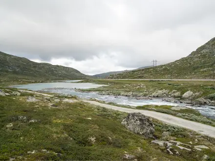
The Romans and Reivers Route is an 84 km point-to-point trail across southern Scotland, from the Forest of Ae in Dumfries & Galloway to Hawick in the Scottish Borders. Allow 4–6 days. It is a moderate walk for fit hikers, though the LDWA rates it challenging because of its remoteness and length. The route suits walkers who are comfortable with forest tracks, drove roads, old Roman road lines, short quiet lanes, sparse services and multi-use gates shared with cyclists and horse riders.
Route Overview
The usual direction is south-to-north / west-to-east, starting at the car park at the southern end of Ae Forest and finishing on Wiltonburn Hill just outside Hawick. Key places in order include Forest of Ae, Beattock Hill / Beattock, Moffat Water, Eskdalemuir Forest, Craik Forest, Roberton, Wiltonburn Hill and Hawick. This is a point-to-point route, so plan transport at both ends and do not rely on frequent resupply. It connects with other Scotland’s Great Trails at Beattock and Hawick, including the Annandale Way. For a very different Scottish trip, compare the Arran Coastal Way or Ayrshire Coastal Path.
Romans, Reivers and old Border ways
The trail’s name reflects two layers of Border history. Roman roads once carried legions and supplies across the Southern Uplands, and the route follows surviving track lines in places. Centuries later, this was Border Reivers country: raiding families on both sides of the Anglo-Scottish frontier whose feuds and cattle rustling shaped local towers, castles and language. The modern multi-use route was created in the 2000s, led by British Horse Society Scotland, to open these historic ways to walkers, cyclists and horse riders.
Notable highlights
Forest of Ae: The western start lies in Ae Forest, a large Forestry and Land Scotland plantation in Dumfries & Galloway. It gives the route an immediate forest-track character and is also known for its mountain-bike trail centre.
Border Reivers country: The trail crosses the lands associated with the Border Reivers, the cattle-raiding families of the Anglo-Scottish frontier. This history gives the route half its name and adds context to the remote drove roads and border landscapes.
Roman roads: Several sections follow the line of old Roman roads across the Southern Uplands. The Craik Cross / Craik Muir Roman road is a recognised heritage path and one of the clearest links to the route’s “Romans” theme.
Eskdalemuir and Samye Ling: Near Eskdalemuir is Kagyu Samye Ling, founded in 1967 as the first Tibetan Buddhist centre established in the West. For walkers, it is an unusual landmark with a temple, stupa, tea-room, shop and possible accommodation.
Craik Forest and Craik Cross Hill: The crossing of Craik Forest reaches the route’s high point at Craik Cross Hill, around 450 m, on the Dumfries & Galloway / Borders watershed. Expect a more open Southern Uplands feel here.
Hawick: The finish is at Hawick, a historic Borders mill town known for knitwear and Common Riding. The route meets the Borders Abbeys Way here.
Challenges to expect
The main challenges are distance, remoteness and logistics rather than technical terrain. Accommodation and resupply are sparse, with B&Bs noted at Beattock, Eskdalemuir and Roberton, plus wild or forest camping. Forest tracks can be straightforward, but moorland and upland sections may be wet, boggy or exposed after rain. Waymarking uses the Scotland’s Great Trails thistle-in-hexagon symbol, but carry OS mapping for backup.
HikeList Score
Romans and Reivers Route scored 88/100 on HikeList's trail-quality metrics.
See score breakdownHide breakdown
- Ideal length 85
- Balanced challenge 100
- Scenery & wildness 74
- Varied terrain 100
- Accommodation 84
- Food & support 94
- Path quality 92
- Season flexibility 89
Computed from length, challenge, scenery & wildness, terrain variety, accommodation, food & support, path quality and season flexibility.
Show more data Show less
- Forest
- Farmland
- Moorland
- River Valleys
- Upland
- Forest Tracks
- Drove Roads
- Roman Road
- Quiet Lanes
- B&Bs
- Wild Camping Spots
- Forest Camping
- Monastery Accommodation
- Family Friendly
- Dog Friendly On Leash
- Restrooms
- Potable Water Sources
- Established Campsites
- Picnic Areas
- Public Transport Access Points
Download Our Full Guide to Romans and Reivers Route FREE!
Get our comprehensive guide to this hike for free. Save it for later reading or print out at home.
Photos from hikers
Taken on the trail by people who've reviewed Romans and Reivers Route.
Romans and Reivers Route: The Complete Guide
 i
Image by tomopitman
i
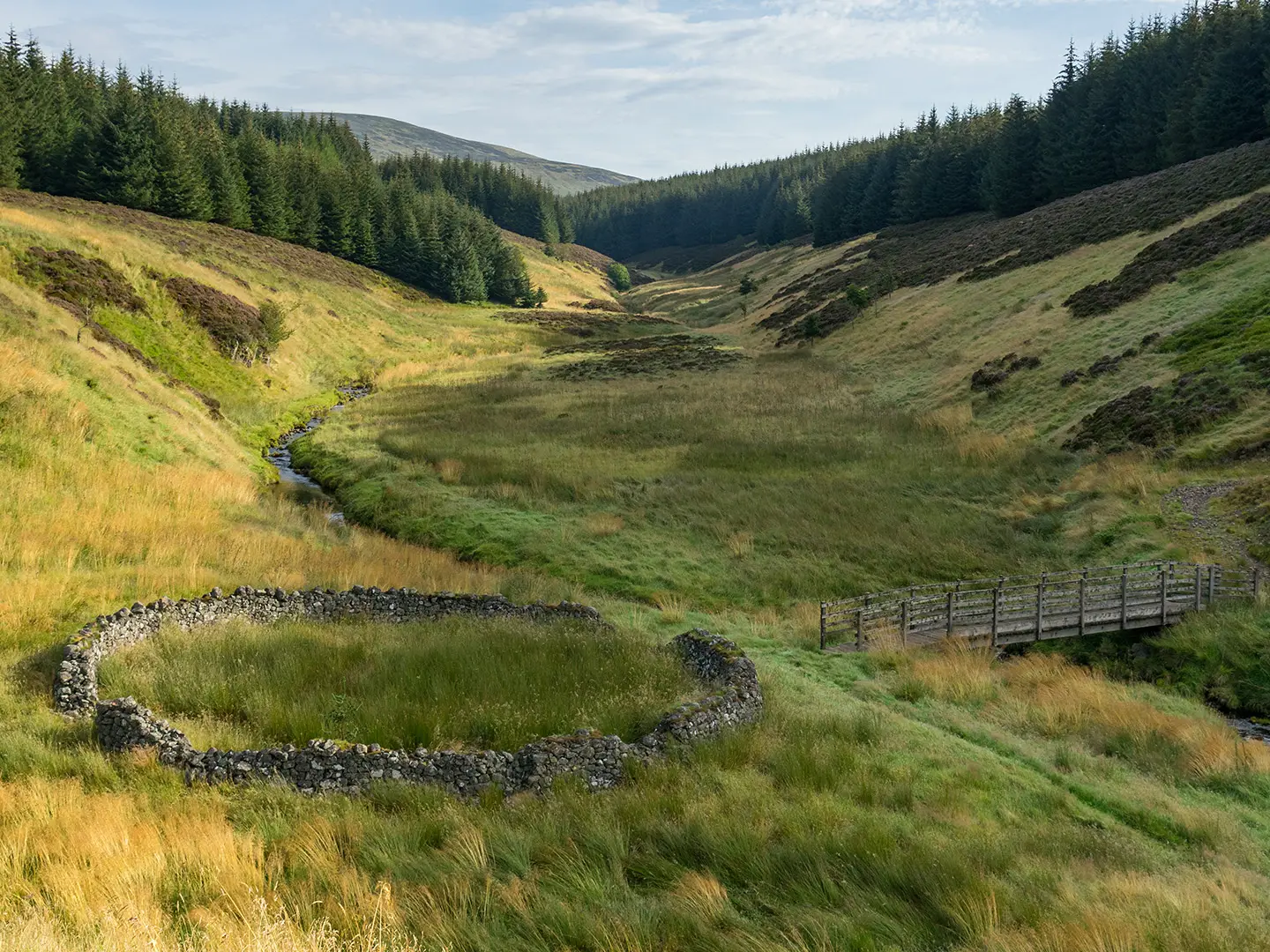
Image by tomopitman The Romans and Reivers Route is a quiet 84 km crossing of the Southern Uplands, running west to east from the Forest of Ae in Dumfries & Galloway to Hawick in the Scottish Borders. It suits experienced, self-reliant walkers who prefer forestry tracks, drove roads and empty upland country to busy honeypot trails.
The route’s character changes gradually: Ae Forest and the Eskdalemuir hills give long, sheltered sections of plantation and stone-surfaced track, while the watershed around Craik Cross Hill opens into broader, more exposed country. Here the trail follows the line of an old Roman road past the site of a Roman watchtower and signal station, the high point of the walk at about 450 m.
East of Craik, the route drops into Teviotdale on old drove-road lines through Border Reivers country, passing Roberton before the final descent from Wiltonburn Hill into Hawick. Settlements are few, but the stops that do exist — Beattock, Eskdalemuir, Craik, Roberton and Hawick — shape the practical rhythm of the walk.
This is not difficult because of technical terrain: gradients are usually steady, with one sharp climb east of Garrogill. The challenge is the combination of long days, sparse accommodation and resupply, remote forest sections, and navigation where felling, windblow or overgrowth can obscure waymarks in Ae and Craik Forests.
This guide covers stages, days, accommodation, food, transport, terrain and the common mistakes to avoid.
Stage-by-Stage Guide
Stage 1: Forest of Ae to Kinnelhead / Beattock
This opening stage sets the tone for the route: quiet, forestry-led and more remote than the modest distance suggests. The trail starts at the car park at the southern end of the Forest of Ae plantation, north of Ae and Parkgate off the A701, then works through Ae Forest towards Kinnelhead and the Beattock area.
Underfoot, expect mainly forest road and purpose-built stone-surfaced track, built for shared use by walkers, cyclists and horse riders. The going is not technically difficult, but forestry operations, windblow and felling can make the way less obvious than the map implies, particularly in Ae Forest.
Waymarking uses the Scotland’s Great Trails thistle-in-hexagon symbol, but this is not a route to follow on signs alone. Carry OS Landranger 78 and 79, plus a GPS or downloaded mapping, and allow extra time if trees or overgrowth obscure the line.
Food and water planning matters from the first day. There are no reliable services at the Forest of Ae trailhead itself, so arrive with the day’s food and enough water to reach the Beattock/Moffat area. Burns and streams are part of the landscape, but they should not be treated as guaranteed drinking-water points without appropriate treatment.
Beattock has B&B accommodation, and Moffat lies around 1 mile off route with a wider choice of shops, services and places to stay. This is one of the most practical overnight stops on the western half of the trail, so accommodation should be booked ahead rather than left to chance.
Public transport does not conveniently serve the actual Forest of Ae trailhead. Most walkers will need a taxi or lift to the start, while the broader western access is via Moffat and Lockerbie, with Lockerbie the nearest railway station. Current bus and taxi options should be checked before travelling.
Stage 2: Beattock to Eskdalemuir / Garwaldwaterfoot area
This is the longest of the suggested five stages and should be treated as a full hill-and-forest day. From Beattock the route briefly shares ground with the Southern Upland Way south and east of Moffat before turning towards Garrogill and the Eskdalemuir hills.
The terrain remains mostly on good tracks, old routes and stone-surfaced paths, but the day has a more committing feel because services are scarce and escape options are limited. The main physical sting is the sharp climb east of Garrogill, gaining about 200 m in roughly 750 m; cyclists may need to push, and horse riders may need to lead.
The shared section with the Southern Upland Way is a useful navigation handrail, but do not assume the whole day is equally straightforward. Once away from the Moffat/Beattock corridor, the route becomes quieter and more exposed to normal Southern Uplands weather: low cloud, wind and poor visibility can make simple tracks feel much less simple.
There are no dependable food stops on the stage itself. Leave Beattock or Moffat fully supplied, and carry enough water for a long day, particularly in warm weather. Any use of natural water should be treated.
Eskdalemuir has B&B accommodation, and Kagyu Samye Ling near Eskdalemuir offers accommodation as well as being one of the route’s notable cultural stops. It is just off the route on the banks of the Esk, with a temple, stupa, gardens and tea-room, but opening arrangements and accommodation availability should be checked before relying on them.
Transport access is limited but better than in the forest interiors. Buses run between Lockerbie and Eskdalemuir, making this a possible joining or leaving point for section walkers, but current timetables should be checked before travelling.
Stage 3: Eskdalemuir to Craik
This stage crosses the high, remote heart of the route, linking Eskdalemuir with Craik Forest and the watershed around Craik Cross Hill. It is not a long stage by distance, but it contains the trail’s most exposed and historically important ground.
The route crosses the White Esk and continues into Craik Forest, where forestry tracks, old lines and upland paths combine. This is one of the areas where overgrown Sitka spruce, stumps, felling and windblown trees can obscure or block the route, so navigation should be treated seriously even in clear weather.
The standout section is the Roman road over Craik Cross Hill. At about 449–450 m, this is the high point of the Romans and Reivers Route and the site of a Roman watchtower or signal station, now a Scheduled Monument and later marked by a cross stone.
In good visibility the watershed gives the broadest upland feel of the trail, with open Southern Uplands ground above the surrounding forest. In poor weather it can be cold, featureless and slow, so this stage is best tackled with a reliable forecast, spare warm layers and enough daylight.
Do not expect food shops or easy resupply between Eskdalemuir and Craik. Carry food for the full stage and enough water, with treatment if using burns. The remoteness also makes it sensible to carry a headtorch and an emergency buffer of food.
Accommodation planning is particularly important here. The Craikhope Outdoor Centre lies near Craik Cross Hill, but availability and access should be checked before booking a stage around it; beds in or around Craik itself should not be assumed. If no suitable accommodation is available, the stage plan may need adjusting.
Public transport options around Craik and Craik Forest are limited. Road access exists in the wider area, but any taxi pick-up or drop-off should be arranged in advance, with the exact meeting point agreed clearly.
Stage 4: Craik to Roberton
East of Craik the character begins to shift from forest and Roman-road upland towards the old drove-road country associated with the Border Reivers. This is a shorter stage, but it still crosses quiet, rural ground where facilities remain sparse.
The walking is generally on drove roads, tracks and short sections of quiet public lane, descending gradually towards the Borthwick Water and Teviotdale side of the route. The terrain is not technically difficult, but after wet weather some grassy or less-used sections may feel slower than the mileage suggests.
This stage is a good place to notice the “Reivers” half of the route: old movement corridors through the Borders landscape rather than dramatic summits. Views open and close with the rolling ground, with less continuous forestry than on the western and central stages.
Food and water availability is very limited. Leave Craik supplied for the day, and do not rely on finding shops or cafés before Roberton. Natural water should be treated if used.
Roberton is one of the few settlements on the eastern half of the route and has B&B accommodation. Because options are limited, booking ahead is essential, especially if walking during a busy period or needing horse-friendly arrangements.
Public transport from small Borders villages can be infrequent or absent for practical trail purposes. Any plan to start, finish or break the route at Roberton should be checked before travelling, and taxis should be arranged in advance.
Navigation is generally less complex than in the worst forestry sections, but the route still needs map attention where tracks, drove roads and lanes meet. Do not rely solely on waymarks at junctions.
Stage 5: Roberton to Hawick
The final stage is short but still feels like a proper upland finish rather than a roadside walk into town. From Roberton the route continues through the Borthwick Water and Teviotdale landscape before climbing towards Wiltonburn Hill and descending into Hawick.
Underfoot, expect a mix of tracks, old drove-road lines, open rural paths and quiet lanes. The gradients are generally manageable, and there is no technical ground, but weather can still matter on the higher, more open sections before the descent.
Wiltonburn Hill gives the last elevated approach before the route drops into Hawick, the historic Roxburghshire mill town on the River Teviot. Hawick is also where the Romans and Reivers Route meets other long-distance lines, including the Borders Abbeys Way and the Cross Borders Drove Road.
There should be no need to carry multiple days of food by this point, but still start from Roberton with enough for the stage. Hawick has a wide range of shops, services and accommodation, making it the most straightforward finish-point on the route.
Near the finish, Wiltonburn Farm and Meadshaw offer B&B plus horse-and-rider accommodation, while Hawick itself provides the main choice of beds. As elsewhere on this route, specialist or rural accommodation should be booked ahead.
Hawick has no railway station, but it is a strong regional bus hub with connections towards Edinburgh and Carlisle. The nearest railhead is the Borders Railway terminus at Tweedbank/Galashiels, reached by bus. Current bus times should be checked before travelling, especially for onward rail connections.
Navigation into Hawick is usually the least remote part of the walk, but care is still needed where rural tracks meet roads and the route descends from Wiltonburn Hill. Keep the map or GPS available until the route is fully finished in town.
Recommended Itinerary
The most practical schedule for most walkers is five days. It keeps the two longest and most remote sections manageable, uses the few settlement stops on the line of the route, and avoids making the final approach to Hawick unnecessarily rushed.
Distances are approximate. Where a variant changes the overnight split, check official mapping before booking.
Standard 5-day itinerary
| Day | From | To | Approx. distance | Why this stage makes sense | Services/accommodation notes |
|---|---|---|---|---|---|
| 1 | Forest of Ae | Kinnelhead / Beattock | 17 km | A sensible first day out of Ae Forest, ending near the Beattock/Moffat service area before the route becomes more remote. | B&B options at Beattock; Moffat is about 1 mile off route and has a wider range of shops, services and accommodation. The Forest of Ae trailhead usually needs a taxi or lift. |
| 2 | Beattock | Eskdalemuir / Garwaldwaterfoot area | 25 km | The longest standard day, but it links the main western service stop with the next realistic overnight area. Expect a remote day with limited opportunities to shorten it once committed. | B&Bs at Eskdalemuir; Kagyu Samye Ling also offers accommodation just off route. Carry food from Beattock/Moffat and do not rely on intermediate services. |
| 3 | Eskdalemuir | Craik | 17 km | A key upland stage crossing towards Craik Forest and the watershed around Craik Cross Hill, where navigation and weather deserve particular attention. | Accommodation is very limited. Craikhope Outdoor Centre near Craik Cross Hill may be useful if it fits the day’s plan; this should be checked before travelling. Wild and forest camping is possible under the Scottish Outdoor Access Code. |
| 4 | Craik | Roberton | 13 km | A shorter day after the forest and watershed section, following the eastern drove-road character towards Borthwick Water and Teviotdale. | B&B accommodation at Roberton. Book well ahead, as there are very few alternatives on this part of the route. |
| 5 | Roberton | Hawick | 12 km | A short final stage over Wiltonburn Hill into Hawick, leaving time for onward buses or an overnight stop in town. | B&B and horse-and-rider accommodation near the finish at Wiltonburn Farm and Meadshaw; Hawick has a wider range of shops, services and accommodation. |
Slower variant: 6 days, best for campers or cautious planners
A slower schedule is useful if carrying a heavy pack, if daylight is short, or if forestry diversions and difficult navigation are likely to slow progress. The challenge is that extra overnight stops are not evenly supplied, so this version usually needs camping, pre-arranged accommodation, or carefully planned transfers.
| Day | From | To | Approx. distance | Why this stage makes sense | Services/accommodation notes |
|---|---|---|---|---|---|
| 1 | Forest of Ae | Kinnelhead / Beattock | 17 km | Keeps the first day straightforward and reaches the Beattock/Moffat service area. | Use Beattock B&Bs or detour to Moffat for wider services. |
| 2 | Beattock | Intermediate overnight before Eskdalemuir | Split of the 25 km Beattock–Eskdalemuir stage; check official mapping before booking | Breaks the longest standard day into two shorter walking days. | This is not a services-led split. Plan to be self-sufficient, or arrange a specific overnight/transfer in advance. |
| 3 | Intermediate overnight before Eskdalemuir | Eskdalemuir / Garwaldwaterfoot area | Remainder of the 25 km Beattock–Eskdalemuir stage; check official mapping before booking | Allows a more conservative approach to the hills west of Eskdalemuir. | B&Bs at Eskdalemuir; Kagyu Samye Ling offers accommodation just off route. |
| 4 | Eskdalemuir | Craik | 17 km | Gives a full day for Craik Forest, Craik Cross Hill and any wayfinding delays. | Very limited accommodation; check Craikhope Outdoor Centre, camping options and any forestry diversions before travelling. |
| 5 | Craik | Roberton | 13 km | Keeps the eastern drove-road section short and unhurried. | B&B at Roberton should be booked well ahead. |
| 6 | Roberton | Hawick | 12 km | Leaves an easy final day into Hawick, useful for onward transport. | Hawick has the best range of finish-line services and accommodation. |
Faster variant: 4 days, best for fit walkers travelling light
A four-day crossing is realistic for strong walkers who are comfortable with long, quiet days and have accommodation fixed in advance. It reduces the number of overnight stops needed, but leaves less margin for forestry obstructions, poor visibility around Craik Cross Hill, or tiredness after the 25 km Beattock–Eskdalemuir day.
| Day | From | To | Approx. distance | Why this stage makes sense | Services/accommodation notes |
|---|---|---|---|---|---|
| 1 | Forest of Ae | Kinnelhead / Beattock | 17 km | A controlled first day to reach the Beattock/Moffat area. | Book Beattock or Moffat accommodation before committing to the start transfer. |
| 2 | Beattock | Eskdalemuir / Garwaldwaterfoot area | 25 km | The main long day of the western half, linking two realistic overnight areas. | Carry supplies; accommodation at Eskdalemuir or Kagyu Samye Ling should be arranged ahead. |
| 3 | Eskdalemuir | Craik | 17 km | Crosses the highest and most exposed part of the route without also pushing on into the eastern valleys. | Overnight options are sparse. Check Craikhope Outdoor Centre, camping plans and current forestry conditions before travelling. |
| 4 | Craik | Hawick | 25 km | Combines the Craik–Roberton and Roberton–Hawick stages into one longer finish, with Roberton as the natural halfway settlement. | Roberton offers a possible fallback overnight if the day needs to be split. Hawick has full town services at the finish. |
A three-day itinerary falls within the official 3–5 day range, but it is a demanding choice on this route. It suits only very fit, self-reliant parties with long-day pace, secure navigation and pre-planned overnight logistics; exact splits should be checked against official mapping before booking.
Planning the Route
The Romans and Reivers Route needs more advance planning than its mileage suggests. The walking is not technically difficult, but the route crosses long forest and upland sections with very few services, limited escape options and waymarking that can be obscured by forestry work, windblow or overgrowth.
Most walkers should plan on four or five walking days. A three-day itinerary is possible for strong, fast walkers, but it compresses the remoter sections and leaves little margin for navigation delays in Ae Forest, Eskdalemuir and Craik Forest.
How many days to allow
A five-day schedule fits the natural stopping points best, especially if using B&Bs or carrying camping kit. The practical stage pattern is:
| Day | Stage | Approx. distance | Planning notes |
|---|---|---|---|
| 1 | Forest of Ae to Kinnelhead / Beattock | 17 km | Reaching the actual Ae Forest trailhead usually needs a taxi or lift. Beattock is the useful overnight area, with Moffat around 1 mile off route for wider services. |
| 2 | Beattock to Eskdalemuir / Garwaldwaterfoot area | 25 km | A longer day with sparse services. Plan food, water and accommodation before setting off. |
| 3 | Eskdalemuir to Craik | 17 km | Remote forest and upland walking, including the approach towards the Craik Cross Hill watershed. Check weather and forestry conditions. |
| 4 | Craik to Roberton | 13 km | Shorter mileage, useful after the high, exposed central section. Accommodation is limited and should be booked well ahead. |
| 5 | Roberton to Hawick | 12 km | A shorter final day into Hawick, where there are shops, accommodation and onward bus connections. |
A four-day walk usually means combining the shorter eastern stages or making a longer push between Eskdalemuir, Craik, Roberton and Hawick. This can work well for fit walkers travelling light, but it reduces flexibility if wayfinding is slow in forestry sections.
A six-day schedule is only likely to make sense if transport, accommodation or camping logistics dictate it. The route has too few villages to create evenly spaced short days without using off-route accommodation, taxis or wild/forest camping.
Accommodation dictates the stages
Daily stages are shaped less by terrain than by where it is possible to sleep. The main accommodation points are Beattock, Eskdalemuir, Craikhope Outdoor Centre near Craik Cross Hill, Roberton, Wiltonburn Farm and Meadshaw near the Hawick end, plus Hawick itself.
Moffat is around 1 mile off route near Beattock and is the main service centre on the western half. It is often the most practical place to use for shops, meals and a wider choice of beds before committing to the quieter middle of the route.
Kagyu Samye Ling at Eskdalemuir also offers accommodation, with a temple, stupa, gardens and tea-room just off the route. Availability, access arrangements and current visitor facilities should be checked before travelling.
Because beds are sparse, accommodation should be booked before finalising daily distances. Do not assume there will be a fallback option in the next village, particularly between Beattock, Eskdalemuir, Craik and Roberton.
Food, water and resupply
Carry enough food for each day, and consider carrying emergency food for delays. Hawick and Moffat have the widest range of shops and services; elsewhere, options are limited and should not be relied on without checking opening times in advance.
Water planning is straightforward at overnight stops, but less predictable during the day. The route crosses burns and streams, yet any natural water used should be treated, and forestry work or livestock can affect water quality.
On long forest days, start with enough water to reach the next reliable stop. This is especially important on the Beattock to Eskdalemuir section and through the Eskdalemuir and Craik Forest areas, where services are sparse.
Navigation and route-finding
The route is waymarked with the Scotland’s Great Trails thistle-in-hexagon symbol, but it should not be treated as a waymark-only walk. Felling, windblown trees, overgrown Sitka spruce and stumps can obscure the line, particularly in Ae Forest and around Craik Forest.
Carry OS Landranger 78 and 79 and a GPS track or mapping app with offline coverage. A paper map and compass are still important, as phone signal and battery life should not be assumed in the forest and upland sections.
Allow extra time where forestry operations have changed the ground. If a waymark disappears, avoid forcing a line through blocked plantation; use the map, forest roads and the known route corridor to relocate the path safely.
Transport planning
The route is linear, and transport is one of the first things to solve. There is no railway on the route itself.
For the western end, Lockerbie is the nearest railhead, with bus or taxi onward travel towards Moffat. Reaching the actual Forest of Ae trailhead normally needs a taxi or lift, so this should be arranged before travel.
For the eastern end, Hawick has no station but is a strong regional bus hub, with onward links towards Edinburgh and Carlisle. The nearest railhead is at Tweedbank/Galashiels on the Borders Railway, reached by bus.
Regular buses serve Moffat and Hawick, and buses also run between Lockerbie and Eskdalemuir. Current timetables, Sunday services, luggage rules and taxi availability should be checked before travelling.
Shortening, extending and section hiking
This is not an easy route to shorten on the day. Once away from Beattock/Moffat, Eskdalemuir, Roberton and Hawick, exits are limited and may depend on pre-booked taxis or lifts.
Section hiking is possible, but it is logistically awkward compared with routes that shadow a railway. Beattock/Moffat, Eskdalemuir and Hawick are the most practical access points from the information available; transport from smaller places such as Craik or Roberton should be checked before travelling.
Extending the walk is most natural at Hawick, where the route meets the Borders Abbeys Way and the Cross Borders Drove Road. Any onward itinerary should be planned separately, with its own accommodation and transport checks.
Weather, season and permits
Spring, summer and autumn are the most practical seasons. The exposed watershed around Craik Cross Hill and the boggier upland sections are best avoided in winter storms, poor visibility and short daylight.
Weather matters most on the central section over Craik Cross Hill, the high point of the trail. In poor conditions, allow extra time for navigation and avoid starting the crossing late in the day.
There is no trail permit or fee for walking the route. Wild and forest camping is permitted under the Scottish Outdoor Access Code, but camping should still be planned responsibly, with lightweight kit, late arrival, early departure and no impact on forestry operations, livestock or access tracks.
Towns, Villages and Overnight Stops
The Romans and Reivers Route has very sparse settlements between the Forest of Ae and Hawick. Accommodation and food need planning before setting off, especially through Eskdalemuir and Craik Forests, where there are long sections with no shops, pubs or easy bail-out points.
Book beds well ahead and do not assume a same-day vacancy in the smaller places. If camping, wild and forest camping is permitted under the Scottish Outdoor Access Code, but you still need to carry enough food and fuel for the remote middle of the route.
Forest of Ae / Ae Forest
The route starts at the car park at the southern end of the Forest of Ae plantation, north of the village of Ae and Parkgate off the A701 near Dumfries. This is a practical trailhead rather than a full service stop, and most walkers will need a lift or taxi to reach it.
There is no railway at the start. The nearest rail option for the western end is Lockerbie on the West Coast Main Line, with onward travel towards Moffat by bus or taxi; reaching the actual Forest of Ae trailhead usually needs a taxi or lift. This should be checked before travelling.
Ae Forest is well known as a 7stanes mountain-bike trail centre, so expect shared-use tracks and other users near the start. Do not rely on the trailhead as a resupply point unless current facilities have been checked in advance.
Kinnelhead
Kinnelhead is the first logical stopping area after the Forest of Ae on the west-to-east route. It sits before the Beattock/Moffat area and can be used to shorten the first stage if accommodation or camping arrangements suit.
Services are very limited here, and it should not be treated as a reliable food stop. Accommodation availability should be checked before travelling, or the day should be planned to continue to Beattock or nearby Moffat.
Beattock
Beattock is one of the key practical overnight stops on the western half of the route. B&B accommodation is available here, making it a useful first-night or early-route base after the Forest of Ae and Kinnelhead section.
Beattock’s railway station closed in 1972, so it is not a rail access point. For rail, use Lockerbie and onward bus or taxi links, or use bus links serving the Moffat area; current times should be checked before travelling.
Food and supplies are more dependable by diverting to Moffat, around 1 mile off route. Beattock itself is best thought of as a bed stop rather than a guaranteed resupply hub unless specific services have been checked in advance.
Moffat
Moffat lies about 1 mile off route and is the main service centre for the western end of the walk. It has a wider range of shops, services and accommodation than the settlements actually on the trail, so it is often the most practical place to resupply, eat properly and reset before the longer, quieter Eskdalemuir and Craik Forest sections.
The route briefly shares ground with the Southern Upland Way near the Beattock/Moffat area, which makes Moffat a useful access and accommodation point for section walkers. Regular buses serve Moffat, and Lockerbie is the nearest railway station to this end of the route, around 16 miles south of Moffat.
Staying in Moffat adds a short off-route detour, but the extra distance is often justified by the better choice of beds and food. Book accommodation ahead in busy periods and check bus times before committing to a schedule.
Garrogill
Garrogill is passed on the way east from Beattock towards Eskdalemuir. It is mainly important as a route landmark before the sharp climb eastwards, rather than as a dependable overnight or resupply stop.
Do not plan on food, shops or transport here unless arrangements have been made in advance. This section is better approached with a full day’s food and enough time for the climb and onward navigation towards Eskdalemuir.
Eskdalemuir
Eskdalemuir is one of the most important overnight points on the route because there are few alternatives in the middle stages. B&B accommodation is available in the area, and it is a sensible stop before or after the more remote sections towards the White Esk, Craik Forest and Craik Cross Hill.
Regular buses run between Lockerbie and Eskdalemuir, making it one of the more useful mid-route access points for section walkers. Timetables should be checked before travelling, as rural services can be limited and may not suit late finishes.
Food options should be planned carefully. Do not assume that there will be a full resupply unless specific shops or meal arrangements have been checked in advance.
Kagyu Samye Ling, Eskdalemuir
Kagyu Samye Ling is just off the route on the banks of the Esk and is a distinctive practical stop as well as a major local landmark. It offers accommodation and has a tea-room, making it useful for walkers timing a stop in the Eskdalemuir area.
Accommodation should be booked in advance and any visitor requirements, meal arrangements and opening times should be checked before travelling. It is not a conventional village pub-and-shop stop, so plan respectfully and do not rely on casual availability.
White Esk crossing
The White Esk crossing is a route landmark rather than a settlement. It sits on the remote middle section between Eskdalemuir and Craik Forest, where walkers should already be carrying food, waterproofs, navigation tools and enough daylight for the onward ground.
There are no dependable services here. Treat it as part of a committing day through upland and forest terrain rather than a place to stop overnight unless camping responsibly under the Scottish Outdoor Access Code.
Craik Forest and Craik Cross Hill
Craik Forest and Craik Cross Hill form the most remote and exposed part of the route. Craik Cross Hill is the high point at about 450 m and the route follows the line of an old Roman road across the watershed.
This is not a service area. The practical overnight option in this part of the route is Craikhope Outdoor Centre near Craik Cross Hill, which should be arranged in advance.
Navigation can be more demanding here than the map suggests, particularly where forestry work, windblow, overgrown Sitka spruce or stumps obscure the line. Carry OS mapping and GPS, and allow extra time before committing to accommodation timings on either side.
Craik
Craik is a useful stopping point after the high ground and forest sections. It sits east of Craik Forest and works well as a staging point before the shorter onward leg towards Roberton.
Services are sparse, so do not assume food, shops or transport. Accommodation and any meals need to be arranged before arrival, or the stage should be planned around camping or continuing to a confirmed bed.
Roberton
Roberton is a small Borders village in the Borthwick Water valley and one of the few settlements on the eastern half of the route. B&B accommodation is available, making it a valuable final-night stop before the descent towards Hawick.
This is a good place to break the route if carrying camping kit or avoiding an overlong final day from Craik to Hawick. Food and evening meal arrangements should be checked when booking, as village services are not something to rely on casually.
Transport options are limited compared with Hawick. If using Roberton as a start or finish point for a section, onward travel should be arranged in advance.
Borthwick Water and Teviotdale
East of Roberton the route follows the Borthwick Water and enters Teviotdale country on the approach to Hawick. This is the historic drove-road and Border Reivers landscape of the final part of the trail, but it is still not a dense service corridor.
Use Roberton and Hawick as the practical planning anchors. Any intermediate accommodation, food or pick-up arrangements should be treated as private pre-booked logistics rather than assumed trail services.
Wiltonburn Hill, Wiltonburn Farm and Meadshaw
The route descends from Wiltonburn Hill towards Hawick near the finish. B&B plus horse-and-rider accommodation is available at Wiltonburn Farm and Meadshaw, which can be useful for walkers, cyclists or riders wanting to stop just short of town.
These are specialist rural accommodation options rather than general service villages. Book ahead, confirm access arrangements, and check whether meals or onward transport are available before relying on them.
Hawick
Hawick is the finish of the Romans and Reivers Route, reached after the descent from Wiltonburn Hill into the town on the River Teviot. It is the strongest service centre on the route, with a wide range of shops, services and accommodation.
There is no railway station in Hawick. The nearest railhead for the eastern end is the Borders Railway terminus at Tweedbank/Galashiels, reached by bus, and Hawick is a regional bus hub with Edinburgh and Carlisle connections.
Hawick is the easiest place to recover, resupply, eat properly and arrange onward travel after finishing. It also connects with the Borders Abbeys Way and the Cross Borders Drove Road, making it a practical junction for longer walking plans.
Getting to the Start
The Romans and Reivers Route starts at the car park at the southern end of the Forest of Ae plantation, north of the village of Ae and Parkgate, off the A701 near Dumfries. This is not a town-centre trailhead: the final approach normally needs a car, taxi or lift.
By train
The most useful railhead for the western end is Lockerbie, on the West Coast Main Line between London and Glasgow/Edinburgh. From Lockerbie, continue by bus or taxi towards Moffat; Beattock’s own station closed in 1972.
Lockerbie is still some way from the actual Forest of Ae start. Most public-transport itineraries will need a final taxi or arranged lift to the trailhead car park. Train times, bus connections and taxi availability should be checked before travelling, especially if arriving late in the day.
By bus
Regular buses serve Moffat, and buses also run between Lockerbie and Eskdalemuir. These are useful for reaching the western side of the route or for joining/leaving around the middle stages, but they do not remove the awkward final access to the Forest of Ae trailhead.
There is no direct public transport stated for the actual start at the Forest of Ae car park. Plan on pre-booking a taxi or arranging a lift from Lockerbie, Moffat, Beattock or another nearby base. Current timetables and operating days should be checked before travelling.
By car
Drive to the Forest of Ae / Ae Forest start car park at the southern end of the plantation, north of Ae and Parkgate off the A701 near Dumfries. The approximate grid reference for the start is NX982893.
Because this is a point-to-point walk finishing in Hawick, taking a car to the start creates an end-of-walk transport problem. Do not assume that leaving a vehicle at the Forest of Ae for several days is suitable or permitted without checking the current parking arrangements. Long-stay parking should be checked before travelling.
A common solution is to travel by public transport to the western side, overnight locally, then use a pre-booked taxi to the trailhead. Another is to arrange a lift to the start and use Hawick’s stronger bus links at the finish.
From the nearest airport
No airport sits conveniently on the route itself. The practical approach is to fly into a UK airport with onward rail access to the West Coast Main Line, then travel by train to Lockerbie and continue by bus or taxi towards Moffat and the Forest of Ae.
Airport-to-trail journeys are likely to involve several connections plus a final taxi or lift. Build in enough time for delays, and check current train, bus and taxi options before booking flights.
Where to stay before starting
The start itself is in a forest setting, so most walkers stay off-route the night before rather than trying to reach the car park early by public transport. Moffat is about 1 mile off the route near Beattock and has a wider range of shops, services and accommodation than the small settlements on the trail.
Beattock also has B&B accommodation and lies on the first-day corridor of the route. Staying in Moffat or Beattock makes it easier to buy food, organise a taxi to the Forest of Ae, and start the first stage without relying on a same-morning long-distance connection.
Accommodation on this route is sparse, so book ahead rather than arriving speculatively. Taxi availability to the Forest of Ae trailhead should also be arranged in advance.
Getting Home from the Finish
The Romans and Reivers Route finishes in Hawick, a useful endpoint compared with the much more remote western trailhead. Hawick has no railway station, so almost all onward journeys start with a bus or taxi connection.
If finishing late in the day, staying in Hawick is usually the simplest option. It avoids relying on evening bus connections after a remote final stage from Roberton and gives more flexibility for travel the following morning.
By train
There is no railway station in Hawick. The nearest railhead for the eastern end is the Borders Railway terminus at Tweedbank/Galashiels, reached from Hawick by bus.
From there, rail connections continue towards Edinburgh. Timetables and the bus-to-train connection should be checked before travelling, especially at weekends, on public holidays and if aiming for a specific long-distance train.
For journeys back towards the western end of the route, Lockerbie is the main rail station mentioned for the Ae/Moffat side, on the West Coast Main Line. Returning to a vehicle or accommodation near the Forest of Ae will usually involve multiple legs: Hawick to a rail or bus hub, onward travel towards Lockerbie or Moffat, then a taxi or lift for the actual Forest of Ae trailhead. This should be planned before starting the walk.
By bus
Hawick is a strong regional bus hub, with bus connections towards Edinburgh and Carlisle. It is therefore a much easier place to leave the trail than the Forest of Ae start, but services are still timetable-dependent rather than turn-up-and-go at all hours.
Use Hawick as the planning point for onward buses rather than Roberton or the final upland section. If the last day runs long, or forestry/navigation delays earlier in the trip have pushed the schedule back, an overnight stop in Hawick is the safer plan.
Current bus times to and from Hawick should be checked before travelling. This is particularly important for Sunday services, evening travel and any journey involving a rail connection at Tweedbank/Galashiels.
By car/taxi
For a point-to-point walk, leaving a car at Hawick and arranging transport to the Forest of Ae at the start can be more convenient than trying to retrieve a car after finishing. The actual Forest of Ae trailhead usually needs a taxi or lift, so car logistics should be arranged as part of the whole trip rather than left until Hawick.
A taxi from Hawick may be useful for local accommodation, delayed finishes or returning to nearby off-route stops, but availability and fares should be checked in advance. Do not assume that a late finish on Wiltonburn Hill will leave enough time to find onward transport the same evening.
If a vehicle has been left at the western end, allow for a slow return journey. Hawick has useful onward transport links, but the Forest of Ae car park is not on a direct rail line and usually requires a final taxi or lift.
From the nearest airport
Airport travel is not a core advantage of this route finish, as Hawick itself has no airport or railway station. The practical approach is to leave Hawick by bus towards a larger transport hub, such as Edinburgh or Carlisle, and connect onwards from there.
Flight-related plans should allow generous time for bus connections, train connections and any overnight stay needed before an early departure. Airport-specific routes and times should be checked before travelling.
Where to stay at the finish
Hawick has a wide range of shops, services and accommodation, making it the natural place to stop at the end of the route. This is especially useful after several days through areas with very sparse services.
There is also B&B plus horse-and-rider accommodation near the finish at Wiltonburn Farm and Meadshaw. These are useful for walkers, cyclists or riders who want to break the final approach, but Hawick is the better base for onward public transport.
For most walkers using buses or trains, booking a night in Hawick after finishing is the most robust plan. It removes pressure from the final day and makes it easier to connect with morning buses towards Tweedbank/Galashiels, Edinburgh or Carlisle.
Which Direction Should You Walk?
The Romans and Reivers Route is normally treated as a west-to-east walk, from the Forest of Ae to Hawick. That direction fits the route’s published identity and gives the clearest practical finish: you begin with the awkward access to Ae Forest, then end in Hawick, a proper Borders town with shops, accommodation and onward bus links.
Walking east-to-west is entirely possible, but it is usually the less convenient choice unless transport, accommodation or weather makes it preferable for a particular trip.
West to east: Forest of Ae to Hawick
West-to-east is the best default for most walkers. The main logistical nuisance — reaching the actual Forest of Ae trailhead — is dealt with at the start, when a taxi, lift or pre-arranged drop-off can be booked without the pressure of catching onward travel at the end of a long final day.
The route then builds naturally across the Southern Uplands. It starts in the forest-road character of Ae Forest, passes Beattock and the Moffat area, crosses the more remote Eskdalemuir and Craik Forest sections, then drops through Roberton and Borthwick Water towards Hawick.
This direction also gives a satisfying finish. After several days of sparse services, reaching Hawick feels like a proper end point: food, beds and regional bus connections are all much easier to arrange there than at the Forest of Ae car park.
The main climbing consideration is the sharp pull east of Garrogill, where the route gains about 200 m in 750 m. West-to-east walkers climb this section rather than descend it, which is hard work but generally more controlled on foot; cyclists and horse riders may need to push or lead here.
East to west: Hawick to the Forest of Ae
The reverse direction has one clear advantage: Hawick is easier to reach at the start. It is a strong regional bus hub, with connections towards Edinburgh and Carlisle, and can be reached from the Borders Railway terminus at Tweedbank/Galashiels by bus.
The drawback comes at the finish. Ending at the Forest of Ae means arranging a taxi or lift from the trailhead, as there is no simple rail access on the route itself and the actual start/finish car park is not as convenient as a town-centre terminus. This should be checked before travelling, especially if finishing late in the day.
East-to-west also means leaving the stronger services of Hawick behind and finishing in the more awkward western access area. Accommodation is sparse in both directions, but the psychological flow is less helpful: instead of walking towards better services, you walk away from them and must solve final transport in advance.
Descending the steep Garrogill climb may appeal to some walkers, but it can be less pleasant in wet or loose conditions. The exposed watershed around Craik Cross Hill is a serious planning point whichever way you walk, particularly in poor visibility, strong wind or short daylight.
Weather, navigation and accommodation flow
There is no route-specific wind advantage strong enough to dictate direction. For this trail, current forestry conditions, daylight and forecast weather matter more than a theoretical prevailing wind benefit.
Navigation is also not made simple by reversing the route. Waymarks can be obscured by forestry felling, windblow and overgrowth, particularly in the Ae and Craik Forest areas, so both directions require OS mapping and a GPS rather than reliance on markers alone.
Accommodation flow is usually easier to plan west-to-east around Beattock or nearby Moffat, Eskdalemuir, Craik or Roberton, then Hawick. Beds and food are sparse enough that the exact direction should be matched to confirmed bookings, not left to decide on arrival.
Recommendation
Walk the Romans and Reivers Route west-to-east, from the Forest of Ae to Hawick, unless there is a specific reason to reverse it. This direction gives the most natural progression, gets the awkward Ae Forest access out of the way at the start, handles the steep Garrogill section as an ascent, and finishes in the best-served town on the route.
Accommodation Along the Route
Accommodation is the main logistical constraint on the Romans and Reivers Route. This is not a trail where walkers can turn up at the end of each day and expect a choice of pubs, hostels or shops; several stages pass through forest, moorland and small settlements with little or no overnight provision.
The strongest bases are Moffat and Hawick. Moffat is about 1 mile off route near Beattock and has a wide range of shops, services and accommodation, making it the most practical first-night stop for many walkers. Hawick, at the finish, has the best choice at the eastern end.
Between those two towns, accommodation is sparse and should be booked well ahead. Known overnight options include B&Bs at Beattock, Eskdalemuir and Roberton, accommodation at Kagyu Samye Ling near Eskdalemuir, the Craikhope Outdoor Centre near Craik Cross Hill, and B&B / horse-and-rider accommodation at Wiltonburn Farm and Meadshaw near the approach to Hawick. Current availability, opening patterns and booking conditions should be checked before travelling.
| Place | Accommodation level | Best for | Notes |
|---|---|---|---|
| Forest of Ae / Ae Forest trailhead | None | Starting the route | Do not plan on finding accommodation at the actual trailhead. Reaching the start usually needs a taxi or lift, so most walkers overnight elsewhere before day one. |
| Kinnelhead | None | Passing through / stage marker | Useful as a route point, but not a reliable overnight base. Continue towards Beattock or Moffat unless camping. |
| Beattock | Limited | First night on a 4–5 day itinerary | B&B accommodation is available, but choice is limited. Book ahead, especially if linking this with transport from Lockerbie or Moffat. |
| Moffat | Good | Best serviced western base | Around 1 mile off route near Beattock, with a wide range of accommodation, shops and services. Often the most practical stop after the Ae Forest section. |
| Garrogill | None | Passing through | No accommodation to rely on. This sits within the long Beattock/Moffat to Eskdalemuir section. |
| Eskdalemuir | Limited | Mid-route overnight stop | B&B accommodation is available in the area. Kagyu Samye Ling also offers accommodation just off route; book in advance and check current arrangements before relying on it. |
| White Esk / Garwaldwaterfoot area | None to very limited | Wild-camping or long-stage planning | This is a remote section rather than a serviced overnight hub. Carry what is needed for the day and have a firm plan for the night. |
| Craik Forest / Craik Cross Hill | Limited | Breaking the remote central section | Craikhope Outdoor Centre near Craik Cross Hill is the key named option in this area. Availability should be checked before travelling. |
| Craik | Limited | Shorter-stage itineraries | Accommodation choice is sparse. Do not assume a bed without a confirmed booking. |
| Roberton | Limited | Final night before Hawick | B&B accommodation makes Roberton a useful stop on a 5-day itinerary. Booking ahead is important because alternatives nearby are limited. |
| Wiltonburn Farm / Meadshaw | Limited | Near-finish stop; horse riders | B&B and horse-and-rider accommodation is available near the approach to Hawick. Useful if splitting the final miles or travelling with a horse. |
| Hawick | Good | Finish, recovery night, onward transport | The main serviced town at the eastern end, with a wide range of accommodation, shops and onward bus connections. |
Booking strategy
For a comfortable inn-to-inn walk, plan around Moffat or Beattock, Eskdalemuir, Craik or Craikhope, Roberton and Hawick. That creates manageable stages, but it depends on sparse rural accommodation being available on the exact dates needed.
A 3-day crossing is possible for strong walkers, but accommodation spacing becomes awkward and the days are long. A 4–5 day plan is usually easier to match to the available overnight stops, especially if carrying camping kit or allowing for slow going through Ae Forest and Craik Forest.
Weekends, holiday periods and event dates can reduce availability in the small places quickly, not because the route is busy but because there are so few beds. Reserve the middle nights before committing to transport at either end.
Camping and flexible options
Wild and forest camping is permitted under the Scottish Outdoor Access Code, making camping a practical way to solve the route’s accommodation gaps. This is particularly useful around the more remote forest and upland sections, where fixed accommodation is limited or absent.
Campers still need to plan food and water carefully. The route passes very few settlements, and the forest sections are not a substitute for proper resupply points.
Luggage transfer and taxi transfers
This route is not as straightforward for luggage-supported inn-to-inn walking as busier National Trails. Dedicated luggage transfer should not be assumed; this should be checked before travelling.
Taxi transfers can help with awkward gaps, especially around the Forest of Ae trailhead or when using Moffat as an off-route base. In the remoter middle sections, taxis need to be arranged in advance and should not be treated as a last-minute fallback.
Camping and Wild Camping
The Romans and Reivers Route is well suited to experienced, self-reliant hikers carrying camping kit, but it is not a campsite-to-campsite trail. The route passes very few settlements, and formal accommodation is sparse, so camping can make the logistics easier — provided you are comfortable finding discreet pitches, carrying food and treating water.
Wild and forest camping is permitted in Scotland under the Scottish Outdoor Access Code, including in the forest and upland country crossed by this route. That right depends on responsible behaviour: camp in small numbers, stay briefly, leave no trace, avoid causing disturbance, and move on if asked to do so by a land manager.
Formal campsites and serviced camping
Do not assume there will be regular formal campsites on or near the line. The known accommodation pattern on this route is mainly B&Bs at Beattock, Eskdalemuir and Roberton, accommodation at Kagyu Samye Ling near Eskdalemuir, the Craikhope Outdoor Centre near Craik Cross Hill, and a wider choice of services in Hawick and nearby Moffat.
If a campsite or paid camping pitch is needed, this should be checked before travelling. Bookable indoor accommodation should also be arranged well ahead, especially if using it to break up a camping itinerary during poor weather.
Where wild camping works best
The most practical wild-camping sections are the remote forest and upland stretches, especially away from villages, farms, roads and the busier approaches to Hawick. Ae Forest, the Eskdalemuir hills and Craik Forest all offer long, quiet stretches where a discreet overnight pitch may be possible, but forestry conditions can change quickly because of felling, windblow and overgrown sections.
Avoid relying on a precise pitch marked in advance. In the Ae and Craik Forest areas the line can be blocked or obscured, so keep enough daylight to adapt the plan and find a safe, low-impact place to stop.
| Route section | Camping implications |
|---|---|
| Forest of Ae to Kinnelhead / Beattock | Forest tracks and plantation ground make this a plausible wild-camping section, but check for forestry works and avoid active operations, stacked timber and vehicle access routes. |
| Beattock to Eskdalemuir | A longer, more committing stage with sparse services. Camping can help split the distance, but the route crosses remote country where water, shelter and navigation all need managing carefully. |
| Eskdalemuir to Craik | One of the most logical camping stretches for self-sufficient walkers. Plan around the exposed approach to Craik Cross Hill and avoid stopping on the Roman road or near the Scheduled Monument area. |
| Craik to Roberton | Quieter drove-road and upland country may offer discreet options, but keep clear of farms, livestock, enclosed fields and settlement edges. |
| Roberton to Hawick | This is a short final stage, so most walkers will not need to camp. Use accommodation or services in Hawick rather than trying to wild camp close to the town. |
Water for camping
Burns and streams are crossed along the route, and named waters include the White Esk, Borthwick Water and the River Teviot near Hawick. Do not rely on every stream running clean or conveniently close to a pitch, particularly in forestry and farmland sections.
All wild water should be treated before drinking. Carry enough capacity to dry camp if needed, especially before the higher, more exposed watershed around Craik Cross Hill or if the next reliable water source is uncertain.
Fire, forestry and seasonal care
Use a stove rather than an open fire. Open fires are a poor fit for this route’s plantation forests, moorland edges and peaty upland ground, and they can cause serious damage in dry or windy conditions.
In forest areas, never camp beneath unstable trees, in windblown timber, beside stacked logs or where forestry vehicles need access. Current forestry diversions and windblow in Ae Forest and Craik Forest should be checked before travelling.
Spring, summer and autumn are the sensible camping seasons. Winter camping is possible only for experienced, well-equipped walkers, as the Craik Cross Hill watershed is exposed, daylight is short and storms can make the remote sections much more serious.
Leave No Trace on this route
Pitch late, leave early and keep the camp small and unobtrusive. Take all litter out, bury human waste well away from paths and watercourses, and avoid soap or washing directly in burns and rivers.
Keep well away from houses, farm buildings, livestock, enclosed fields, the grounds of Kagyu Samye Ling unless staying there by arrangement, and any signed forestry work areas. The Roman road and watchtower area on Craik Cross Hill is a Scheduled Monument, so treat it as a heritage site: do not camp on it, dig into it, move stones or disturb the ground.
Food, Water and Resupply
Food planning is one of the main logistical issues on the Romans and Reivers Route. This is not a trail with regular village shops, pubs and cafés: after the Moffat/Beattock area, services are sparse until Hawick, with only limited options around Eskdalemuir and accommodation stops elsewhere.
Treat the route as a self-catered crossing through forest and upland. Carry lunch, snacks and emergency food for each walking day, and do not rely on finding food during the day unless an opening time has been checked before travelling.
Main resupply points
Moffat, about 1 mile off route near Beattock, is the key western resupply point. It has a wide range of shops, services and accommodation, so it is the best place to buy food before the more remote middle stages.
Eskdalemuir has accommodation, and Kagyu Samye Ling near Eskdalemuir has a tea-room and accommodation just off the route. Opening days and hours can vary, so this should be checked before travelling.
Roberton is useful as an accommodation stop, but no full resupply should be assumed there. Hawick has a wide range of shops, services and accommodation and is the natural end-of-route resupply point.
Water
The route crosses burns and streams, and accommodation stops are the most reliable places to refill. Natural water should be treated or filtered, especially in forestry, farmland and upland grazing areas.
Carry enough water to complete each stage without depending on a guaranteed tap or open café en route. On the longer Beattock–Eskdalemuir stage and the remote Eskdalemuir–Craik/Craik Forest section, start with a full day’s water capacity or a reliable filter/treatment method.
Stage-by-stage food and water planning
| Section | Food availability | Water availability | Notes |
|---|---|---|---|
| Forest of Ae to Kinnelhead / Beattock | No reliable food should be assumed on the trail. Beattock has accommodation; Moffat is about 1 mile off route and is the main nearby resupply point. | Refill at accommodation or nearby services where available. Burns and streams may be present, but natural water should be treated. | Arrive at the Forest of Ae already supplied. The trailhead itself should not be treated as a food stop. |
| Beattock to Eskdalemuir | Moffat/Beattock is the last easy western resupply area. No routine food stops should be assumed over the hills towards Eskdalemuir. | Carry enough for the full stage. Natural water may be available from burns and streams, but filter or treat it. | This is one of the longer practical stages, so carry lunch, snacks and spare food before leaving Beattock or Moffat. |
| Eskdalemuir to Craik | Limited options around Eskdalemuir; Kagyu Samye Ling has a tea-room just off route, but opening times should be checked before travelling. No reliable food through Craik Forest should be assumed. | Refill before leaving Eskdalemuir. Streams and burns may offer backup water, but treatment is needed. | This is a remote forest and watershed section. Carry enough food for the full day and allow for delays if forestry work, windblow or overgrowth slows progress. |
| Craik to Roberton | No full resupply should be assumed at Craik or Roberton. Accommodation may provide meals or packed food only by arrangement. | Refill at accommodation where booked. Treat any natural water. | Check meal arrangements when booking. Do not arrive expecting a shop. |
| Roberton to Hawick | No reliable food should be assumed until Hawick. Hawick has a wide range of shops, services and accommodation. | Start with enough water for the stage; refill fully in Hawick at the finish. | This is a shorter final stage, but still rural until the descent into Hawick. |
Practical resupply strategy
For most walkers, the simplest plan is to buy substantial food in Moffat before committing to the middle of the route, then carry enough to reach the next booked accommodation and ultimately Hawick. If using B&Bs or Kagyu Samye Ling accommodation, ask in advance about evening meals, breakfast times and packed lunches.
Rural opening hours can be limited, especially on Sundays, in winter and outside the main visitor season. Cafés, tea-rooms and small services should be checked before travelling, and any essential food should be carried rather than left to chance.
Campers need a more conservative approach. Carry evening meals and breakfasts for the remote sections, plus an emergency meal in case a planned shop, tea-room or accommodation meal is unavailable.
Terrain, Conditions and Difficulty in Practice
Underfoot: mostly firm, but not consistently easy
The Romans and Reivers Route is not a technical hill walk. There is no scrambling, no steep mountain ground and little to trouble a walker who is comfortable on rough tracks, forest roads and upland paths.
Most of the distance is on forest road, purpose-built stone-surfaced path, old Roman road, historic drove road and short sections of quiet public lane. This generally makes the walking straightforward underfoot, especially compared with rougher Southern Uplands routes.
The difficulty comes from the length of the days, the isolation between services and the fact that the line can become harder to follow in forestry. Ae Forest and Craik Forest are the main areas where felling, windblow, overgrown spruce and stumps can obscure the path or waymarks.
Forest, moorland and open country
The route spends long periods in Sitka-spruce plantation, particularly through Ae, Eskdalemuir and Craik Forests. These sections can feel sheltered in poor weather, but they can also be monotonous and awkward to navigate when forestry work has changed the ground.
Between the plantations the route crosses more open farmland, upland and moorland. These sections are generally not high by Scottish hill standards, but they are exposed enough for wind, rain and poor visibility to matter, especially around the watershed at Craik Cross Hill.
Craik Cross Hill, at about 450 m, is the high point and the most open part of the trail. In clear weather it is a straightforward upland crossing; in low cloud, driving rain or winter conditions it becomes a navigation and exposure problem rather than a technical one.
Climbs and descents
The total ascent of about 1,695 m is spread across a rolling west-to-east crossing rather than concentrated into one mountain day. The route cuts across the grain of the Southern Uplands river valleys, so the effort often comes as repeated climbs and drops rather than a single sustained ascent.
The main exception is the sharp pull east of Garrogill, where the route climbs about 200 m in 750 m. Walkers should expect a short, hard effort here; cyclists may need to push, and horse riders may need to lead.
Elsewhere the gradients are generally more forgiving. The final approach descends from Wiltonburn Hill into Hawick, with the effort easing as the route drops towards Teviotdale.
Mud, bog and wet ground
Although much of the route is on firm stone or forest track, it should not be treated as an all-weather hard-surface trail. Boggy upland sections occur, and wet ground is likely after prolonged rain.
Burns and streams are crossed along the way. The brief does not support planning for major river fords, but wet approaches, soft margins and slippery ground around smaller crossings should be expected in poor conditions.
Waterproof footwear is sensible for most walkers, especially outside high summer or after rain. Fast-drying trail shoes may be adequate for experienced walkers in settled conditions, but the remoteness and forestry debris make more protective footwear a safer default.
Road walking, gates and multi-use design
Road walking is limited to short sections of quiet public lane. The route is much more a forest-track, drove-road and upland-path journey than a lane-walking route.
It is a multi-use trail for walkers, cyclists and horse riders, so it was built with shared use in mind. Self-closing gates and stone-surfaced paths are part of the route character, and stiles are not a defining feature.
In farmland and open country, leave gates as found and expect stock management to shape the line of travel. The route passes through a working rural landscape, not a managed walking corridor with frequent facilities.
Navigation difficulty
Navigation is the main reason the route feels more challenging than its modest height and generally good surfaces suggest. It is waymarked with the Scotland's Great Trails thistle-in-hexagon symbol, but waymarks can be lost or bypassed where forestry has been felled, blown down or become overgrown.
Ae Forest and Craik Forest deserve particular care. Do not rely on waymarks alone; carry OS Landranger 78 and 79 and a GPS route, and allow extra time where the line is unclear.
The open ground around Craik Cross Hill also needs proper navigation in poor visibility. The old Roman road gives the route a strong historic line, but mist and bad weather can still make the watershed feel featureless.
Seasonal conditions
Spring, summer and autumn are the practical seasons for most walkers. Longer daylight helps with the longer remote stages, and the open watershed is less committing outside winter storms.
After heavy rain, expect softer upland sections, muddier approaches to burns and slower going through any churned forestry ground. In late summer and autumn, overgrowth in forest sections can also make the line less obvious.
Winter is not impossible for suitably experienced walkers, but it is a poor season for a casual attempt. Short daylight, storms, cold wet ground and poor visibility around Craik Cross Hill increase the seriousness of a route that already has sparse services and long gaps between settlements.
Current forestry diversions, windblow and access issues should be checked before travelling, especially for Ae Forest and Craik Forest. Conditions in managed plantations can change quickly and may affect both timings and navigation.
Weather and Best Time to Walk
The Romans and Reivers Route is best treated as a spring, summer or autumn walk. The terrain is not high mountain ground, but the route is remote, exposed in places and dependent on clear navigation through forestry areas where waymarks can be obscured by felling, windblow and overgrowth.
Late spring to early autumn gives the best balance of daylight, ground conditions and accommodation practicality. Winter is a poor choice for most walkers because short daylight, storms, snow or frozen ground can turn the exposed watershed around Craik Cross Hill and the boggier upland sections into a much more serious undertaking.
Best walking season
Spring and early autumn are often the most practical periods for fit walkers: enough daylight for the longer Beattock to Eskdalemuir day, fewer problems with heat, and generally better conditions for carrying a full pack than in poor winter weather. Autumn can be excellent on the drove roads and forest tracks, but deteriorating daylight matters on this route because escape points and services are sparse.
Summer gives the longest days, which is useful if forestry obstructions or lost waymarks slow progress in Ae Forest or Craik Forest. It is also the season when accommodation demand can be awkward on a route with very few beds, so B&Bs at Beattock, Eskdalemuir and Roberton, plus any stay at Kagyu Samye Ling or Craikhope Outdoor Centre, should be arranged well ahead.
Weather risks that matter on this route
Rain is the main day-to-day factor. Much of the trail uses forest road or stone-surfaced path, but the route also crosses open moorland, old road lines, drove roads and upland sections that can become wet, slow and harder to read underfoot.
Wind and poor visibility matter most on the open high ground around Craik Cross Hill, the route’s high point at about 450 m. In cloud, rain or mist, the Roman road line and the approach through Craik Forest require proper map-and-GPS navigation rather than relying only on waymarks.
Storms are a particular concern in the forest sections. Ae Forest and Craik Forest are already areas where windblown trees, forestry work, overgrown spruce and stumps can block or obscure the line, so allow extra time and check current forestry diversions before travelling.
Winter walking
The route is not a realistic winter choice for a first long-distance walk. There is no technical mountaineering ground, but the combination of short days, remote forest miles, limited services and exposed upland makes winter conditions unforgiving.
Experienced, well-equipped walkers may be able to complete sections in settled weather, but the full crossing should only be attempted with conservative stage lengths, reliable navigation, warm and waterproof kit, and firm accommodation or camping plans. Weather and daylight should be checked before committing to the Craik Cross Hill section.
Surface and access by season
Underfoot conditions are generally better than many Southern Uplands routes because the trail uses long stretches of forest road, purpose-built stone path and quiet lanes. After prolonged rain, expect slower going on open moorland, old road lines and any less-used sections affected by vegetation.
There are no routine seasonal closures to plan around, but forestry operations, windblow and diversions can affect the route at any time. Current route condition information should be checked before travelling, especially for Ae Forest and Craik Forest.
Accommodation and daylight planning
Daylight is a practical constraint because the route has long gaps between settlements and few easy bail-out options. The Beattock to Eskdalemuir stage is a long day, and any delay caused by navigation, forestry obstruction or bad weather can quickly matter.
Accommodation is sparse throughout the route, regardless of season. Book ahead at Beattock, Eskdalemuir, Roberton and near the finish, and confirm current availability before travelling; Hawick and Moffat have more options, but Moffat is about 1 mile off route.
Safety Notes
The Romans and Reivers Route is not technically difficult, but it is a remote Southern Uplands crossing with long forest and upland sections, sparse services and places where forestry work can obscure the line. Treat it as a self-reliant route rather than a waymarked lowland stroll.
Emergency help
In an emergency in the UK, call 999 or 112 and ask for the relevant service. For an accident, serious injury, exposure risk or a lost party in remote ground, ask for Police, then Mountain Rescue.
Do not assume continuous mobile signal in the Ae, Eskdalemuir and Craik Forest sections or around the open watershed near Craik Cross Hill. Carry a charged phone, a power bank, OS mapping, a compass and a GPS device or offline route file.
Navigation and forestry hazards
The route is waymarked with the Scotland’s Great Trails thistle-in-hexagon symbol, but waymarks may be missing, hidden or made irrelevant by forestry felling, windblow and overgrowth. This is a particular concern in the Forest of Ae / Ae Forest and Craik Forest areas.
Carry OS Landranger 78 and 79 or equivalent detailed mapping, and do not rely on waymarks alone. If a line is blocked by fallen trees or forestry operations, do not climb through unstable timber or enter active work sites; retreat to a safe point and use the map to identify a sensible alternative. Current forestry diversions should be checked before travelling.
Weather and exposure
Much of the route is on forest road or stone-surfaced path, but the open ground around Craik Cross Hill is exposed and is the highest point of the trail at about 450 m. Wind, rain, poor visibility and cold can make this section feel far more serious than the altitude suggests.
In spring and autumn, short daylight and wet upland ground can slow progress. In warm weather, the long forest-road sections can still be tiring because services are limited and there may be long gaps between reliable places to rest or resupply.
Carry waterproofs, warm layers, hat and gloves even outside winter. In hot weather, start early, carry enough water for the day and take shade breaks where possible.
Road, track and multi-use safety
The route uses a mix of forest roads, drove roads, stone-surfaced paths and short sections of quiet public lane. Stay alert on lanes, especially on bends, and assume local traffic may be moving faster than expected.
This is a multi-use trail for walkers, cyclists and horse riders. Keep dogs under close control, step aside safely for horses and be especially aware in the Forest of Ae, which is also known for mountain biking.
Livestock and dogs
The route passes through open farmland as well as forest and moorland. Give livestock a wide berth, avoid getting between cows and calves, and keep dogs under close control wherever animals are present.
Use gates carefully and leave them as found. The route was designed with self-closing gates, but do not rely on every gate closing properly in poor weather or after forestry and farm traffic has passed through.
Burns, streams and water
Burns and streams are crossed along the route, including in the Eskdalemuir and White Esk areas. Treat wet stone, timber, mud and grass around crossings as slip hazards, particularly after rain.
Do not enter fast or swollen water. If a crossing looks unsafe after heavy rain, wait, retreat or find a safer mapped alternative rather than forcing it. Any water taken from burns or streams should be treated before drinking.
Solo hiking
Solo walkers should be realistic about the remoteness of the forest sections and the limited number of settlements on the route. Leave a route plan with someone reliable, including intended overnight stops at places such as Beattock, Eskdalemuir, Craik, Roberton or Hawick.
Agree a check-in routine, and make clear what action should be taken if contact is missed. Carry enough food, water and warm clothing to cope with delays caused by navigation problems, windblow or poor weather.
Daily safety checks
Before setting off each day, check:
- The weather forecast, especially wind, rain, temperature and visibility for the Craik Cross Hill watershed.
- Daylight available for the planned stage.
- Current forestry diversions, windblow and access restrictions in Ae Forest and Craik Forest.
- That OS mapping, compass, GPS/offline route file, phone and power bank are ready.
- Food and water for the full day, allowing for sparse shops and services.
- Accommodation or onward transport arrangements, especially where relying on Beattock, Eskdalemuir, Roberton, Hawick or a taxi/lift to the Forest of Ae trailhead.
- Any bus times, taxi arrangements or pick-ups needed that day. This should be checked before travelling.
Gear Recommendations
The Romans and Reivers Route is not a technical mountain route, but it is a self-reliant Southern Uplands crossing with long forest sections, sparse services and real navigation risk where forestry work has obscured the line. Pack for wet ground, changeable upland weather and the possibility of slower-than-planned progress through Ae Forest and Craik Forest.
Footwear
Waterproof walking shoes or lightweight boots suit most walkers, provided they have a firm sole for long days on forest road, stone-surfaced path and drove road. The route is generally good underfoot, but boggy upland sections, wet grass, burns and churned forestry ground make mesh trail shoes a poorer choice in sustained wet weather.
Boots are worth considering if carrying camping kit, walking after heavy rain or tackling the exposed watershed around Craik Cross Hill in colder conditions. Gaiters are useful rather than essential: they help on wet grass, muddy forestry edges and any overgrown sections through Sitka spruce.
Waterproofs and Layers
Carry full waterproofs even in summer. Much of the route is sheltered by plantation, but Craik Cross Hill and the open moorland sections can be exposed to wind and rain, with few easy escape options once committed.
A warm mid-layer, hat and gloves are sensible outside high summer. The high point is only around 450 m, but the route crosses quiet upland country where a wet, windy delay can become cold quickly.
Navigation
Do not rely on waymarks alone. The route is waymarked with the Scotland’s Great Trails thistle-in-hexagon symbol, but windblown trees, felling and overgrown spruce can obscure the line, especially in Ae Forest and Craik Forest.
Carry OS Landranger 78 and 79, plus a GPS device or phone mapping app with the route downloaded offline. A power bank is strongly recommended, particularly for walkers using a phone as their main navigation tool over several days.
A compass remains useful in poor visibility on the more open sections and where forestry tracks create confusing junctions. Allow extra time for navigation rather than planning each day on distance alone.
Water and Food Carry
Services are sparse between the Forest of Ae, Beattock, Eskdalemuir, Craik, Roberton and Hawick. Carry enough food for the full walking day, with an emergency meal or high-calorie reserve in case forestry diversions, windblow or tiredness slow progress.
Water should be managed conservatively. The route crosses burns and streams, but natural water should be treated or filtered, and availability may vary by season and exact stopping point. Refill at accommodation and settlements whenever possible rather than assuming convenient supplies on the trail.
Trekking Poles
Trekking poles are optional but useful. They help with balance on wet stone track, overgrown forestry margins and the sharp climb east of Garrogill, and they reduce strain on longer days carrying a heavy pack.
For lightweight inn-to-inn walkers on dry ground, poles are a preference rather than a necessity. For campers, they are more valuable because the extra pack weight makes the rolling terrain more tiring.
Camping Gear
Wild and forest camping is permitted under the Scottish Outdoor Access Code, but this route is better suited to experienced campers than first-time backpackers. Choose a robust shelter, a warm sleeping system for cool upland nights and a stove if planning to be away from accommodation or cafés.
Camping kit should be compact and weatherproof rather than ultralight at all costs. In the forest sections, ground can be wet, uneven or affected by forestry operations, so a reliable groundsheet and careful pitch choice matter.
Campers should carry more food than inn-to-inn walkers because there are few places to resupply. Rubbish must be packed out, and fires are not appropriate in forestry areas.
Sun, Insects and Seasonal Extras
Sun protection is still worth carrying: the open sections over the watershed and drove roads can be exposed despite the route’s forest character. In warmer months, insect repellent and a head net can make evenings and still woodland sections more comfortable.
In spring and autumn, add a warmer insulating layer and a headtorch with spare power. Short daylight and winter storms make the exposed upland and boggy sections less forgiving, so winter conditions call for a more conservative plan and extra warm kit.
Pack Strategy by Walking Style
Inn-to-inn hikers: keep the pack light, but do not strip out safety gear. Waterproofs, warm layer, offline navigation, power bank, first-aid basics, headtorch, lunch and spare food should still be carried every day because settlements and services are widely spaced.
Campers: prioritise a weatherproof sleep system, stove, water treatment and enough food for remote sections. The route’s gentle gradients help, but the cumulative distance and forestry-navigation delays make an overloaded pack a real disadvantage.
Fast or section hikers: lightweight kit works if the weather window is stable and transport has been planned carefully, but navigation should not be minimised. A downloaded GPX, map backup, waterproof shell, warm layer, emergency food and a reliable phone battery are the minimum sensible baseline for longer sections.
Budget and Costs
The Romans and Reivers Route is free to walk, with no permit or trail fee. The real cost is created by its sparse accommodation, limited resupply and the need to arrange transport at both ends, especially the taxi or lift usually needed to reach the Forest of Ae trailhead.
All figures below are planning allowances in GBP, not fixed tariffs. Accommodation, taxis, food and bus fares should be checked before travelling, especially because several overnight options are small rural businesses with limited capacity.
Main cost drivers
| Cost item | What to budget for |
|---|---|
| Trail access | Public transport can get you close to the route via Lockerbie, Moffat and Hawick, but the Forest of Ae start normally needs a taxi or lift. Get a quote in advance rather than assuming a bus fare. |
| Accommodation | B&Bs and small rural stays are available at or near Beattock, Eskdalemuir and Roberton, with more choice in Hawick and Moffat. Book well ahead; scarcity can force expensive or awkward alternatives. |
| Food | Moffat and Hawick have the widest services. Between them, resupply is limited, so carry meals and snacks for the forest and upland sections. |
| Camping | Wild and forest camping is permitted under the Scottish Outdoor Access Code, making a low-budget crossing possible for self-sufficient walkers. Do not rely on frequent formal campsites along the line of the route. |
| Luggage transfer | There is no route-wide service to assume. If luggage movement is needed, ask accommodation providers or local taxis for a private arrangement. This should be checked before travelling. |
Budget, mid-range and comfortable approaches
| Style | Typical approach | Indicative trail spend, excluding long-distance travel to Scotland |
|---|---|---|
| Budget | Wild/forest camping, supermarket or carried food, minimal paid meals, public transport as far as practical, shared taxi/lift to the Forest of Ae if possible | £80–£180+ per person |
| Mid-range | Mostly B&Bs or simple accommodation at Beattock, Eskdalemuir, Roberton and Hawick, some packed food, some evening meals where available, public transport plus taxi to the start | £350–£650+ per person |
| Comfortable | Private rooms where available, extra night in Moffat or Hawick, more meals out, taxis used to simplify access or shorten awkward transfers | £600–£900+ per person |
These ranges assume a 4–5 day crossing. A faster 3-day itinerary may reduce accommodation nights but usually increases pressure on food planning and transport timing; a 5–6 day itinerary is often easier on the legs but adds nights and meals.
Accommodation costs
The cheapest way to complete the route is to camp responsibly and carry enough food. That keeps overnight costs low, but it increases pack weight and makes bad weather, wet gear and long forest sections more demanding.
Using B&Bs or small rural accommodation is more comfortable but must be planned early. Useful stopping areas include Beattock, Eskdalemuir and Roberton, with additional services about 1 mile off route in Moffat and a wider range at the finish in Hawick. Kagyu Samye Ling at Eskdalemuir and Craikhope Outdoor Centre near Craik Cross Hill may also be relevant depending on itinerary and availability.
For planning, rural B&B or private-room accommodation in this part of Scotland is best treated as a significant nightly cost rather than a hostel-style expense. Single occupancy can be notably more expensive per person than two people sharing.
Food and resupply costs
Self-catering hikers should allow roughly £10–£25 per day for trail food, depending on how much is bought before the walk and how many hot meals or café stops are added. A more comfortable food budget, with evening meals where available and extra drinks or packed lunches, is closer to £30–£60 per day.
The important issue is not just price but availability. The route passes very few settlements, so food should be bought before committing to the longer sections through Eskdalemuir and Craik Forests. Moffat and Hawick are the most useful service points, while intermediate stops should not be relied on for full resupply unless arrangements have been checked in advance.
Transport costs
At the western end, the nearest railway station is Lockerbie, with bus or taxi links towards Moffat. The actual Forest of Ae trailhead normally needs a taxi or a lift, so this is a key line in the budget. If travelling solo, the taxi leg can cost disproportionately more than expected; sharing it makes a noticeable difference.
At the eastern end, Hawick has no railway station but is a strong regional bus hub, with onward links towards Tweedbank/Galashiels for the Borders Railway and towards Edinburgh or Carlisle. Bus times and connections should be checked before travelling, particularly if finishing late in the day.
Luggage transfer and packages
This is not a route where walkers should assume daily luggage transfer is readily available. If bags need moving between B&Bs, arrange it directly with accommodation providers or local taxi firms and get a clear price before booking the itinerary.
Guided or self-guided walking packages are not something to depend on for this trail. If using an operator, confirm that they specifically cover the Romans and Reivers Route, including the Forest of Ae start, the Eskdalemuir/Craik Forest sections and the finish in Hawick.
Luggage Transfer, Guided Tours and Support Services
The Romans and Reivers Route is a poor choice for turning up and improvising support day by day. The trail passes through long, quiet forest and upland sections, with only a few practical service points at Beattock, Eskdalemuir, Craik, Roberton and Hawick, plus Moffat about 1 mile off route near Beattock.
Do not assume the kind of frequent baggage-transfer network found on busier long-distance trails. If walking with a light daypack matters, arrange luggage movement before booking accommodation, and check that each overnight stop can receive bags.
Luggage transfer
A baggage service is most useful on this route if you are staying in fixed accommodation at Beattock, Eskdalemuir, Craik or Roberton and want to avoid carrying camping kit through the forest sections. It is less useful for wild or forest camping, because bags need a reliable staffed drop-off point.
The practical approach is to ask accommodation providers whether they can recommend local taxis or couriers for bag movement between stops. This is especially important around Eskdalemuir and Craik, where services are sparse and the route spends long periods away from settlements.
Before relying on luggage transfer, confirm:
| Check | Why it matters on this route |
|---|---|
| Exact overnight addresses | Some stops are small rural properties rather than town-centre accommodation. |
| Bag collection and delivery times | Long stages and limited staffing can make late arrivals awkward. |
| Access to the property by vehicle | The walking line itself uses forest tracks, drove roads and upland paths; bags should be sent to accommodation, not to the trail. |
| Contingency if forestry diversions delay you | Windblow, felling and overgrowth can slow progress in Ae Forest and Craik Forest. |
| Current price and payment method | Costs vary by distance, provider and number of bags; confirm current details when booking. |
Self-guided walking packages
Self-guided packages may suit walkers who want accommodation booking, route notes and luggage movement arranged as one itinerary. This is particularly useful on the Romans and Reivers Route because beds are limited and the transport at the Forest of Ae start normally needs a taxi or lift.
Any package should be checked carefully against the actual route logistics. Make sure it covers the Forest of Ae trailhead rather than just Moffat or Beattock, includes realistic staging through Eskdalemuir and Craik, and allows for current forestry conditions in Ae Forest and Craik Forest.
A self-guided package is unnecessary for experienced walkers who are happy to book sparse accommodation directly, carry OS mapping and GPS, and arrange their own taxis. It can, however, save a lot of administration where accommodation availability is tight.
Guided walks
Guided trips are not essential for the terrain: the route has no technical mountain ground and is mostly on forest road, stone-surfaced path, old Roman road, drove road and quiet lane. The value of a guide is in navigation, local logistics and confidence through the more remote sections.
A guided option is most relevant for groups, less experienced long-distance walkers, or anyone concerned about losing the line where waymarks are obscured by forestry work, windblow or overgrown spruce. It may also appeal to walkers interested in the Roman road over Craik Cross Hill and the Border Reivers context of Teviotdale.
If booking a guide, check that the itinerary includes the exposed watershed around Craik Cross Hill, that the guide is current on forestry diversions, and that transport is arranged for the Forest of Ae start and the Hawick finish.
Taxi transfers and trailhead access
Taxis are the most important support service on this route. The Forest of Ae start is not a convenient public-transport trailhead, so most walkers should plan a taxi or lift to the car park at the southern end of Ae Forest.
At the western end, Lockerbie is the nearest railway station for the Moffat/Ae side, with onward bus or taxi links towards Moffat. Beattock has no active railway station. At the eastern end, Hawick has no station but is a useful regional bus hub, with onward public transport towards railheads such as Tweedbank/Galashiels.
Taxi support can also be useful for:
- reaching accommodation off route, especially around Moffat or Kagyu Samye Ling near Eskdalemuir;
- shortening a stage in poor weather or after delays in forestry sections;
- moving between Hawick and onward public transport;
- supporting a group with luggage where no regular baggage service is arranged.
Book taxis ahead rather than assuming availability on the day, especially for early starts, Sunday travel, rural pick-ups and the Forest of Ae trailhead. Current bus times to Moffat, Hawick and the Lockerbie–Eskdalemuir area should also be checked before travelling.
Support for cyclists and horse riders
The route is multi-use, so cyclists and horse riders should think about support differently from walkers. The long forest-road sections suit self-sufficient travel, but the steep pull east of Garrogill may require pushing a bike or leading a horse.
Horse-and-rider accommodation is available near the finish at Wiltonburn Farm and Meadshaw, while other overnight options are sparse and should be booked well ahead. Riders and cyclists should also check current forestry access, diversions and windblow before setting out, particularly in Ae Forest and Craik Forest.
Shorter Hikes and Best Sections
The Romans and Reivers Route is not especially easy to sample: settlements are sparse, there is no railway on the route itself, and several logical break points need a taxi, lift or pre-booked accommodation. The simplest shorter sections are therefore those that start or finish near Moffat, Eskdalemuir, Roberton or Hawick.
Distances below use the practical stage distances for the full route. Refine them with OS mapping before committing to transport or accommodation.
Best options at a glance
| Best for | Start and end | Approx. distance | Why choose it | Transport and logistics |
|---|---|---|---|---|
| Best day walk / easiest first taste | Roberton to Hawick | 12 km | One of the shortest natural sections, with a strong finish into Hawick via Wiltonburn Hill and Teviotdale. It gives a taste of the eastern “Reivers” half without committing to the remote forest crossings. | Hawick is the best-served endpoint, with regional bus links including Edinburgh and Carlisle connections via the Borders network. Getting to Roberton needs planning; local taxi or lift arrangements should be checked before travelling. |
| Best section for scenery and history | Eskdalemuir to Craik | 17 km | This is the key high-level section: White Esk, Craik Forest, Craik Cross Hill and the line of the Roman road across the watershed. Craik Cross Hill is the route’s high point and the site of the Roman watchtower / signal station. | Eskdalemuir has accommodation options including Kagyu Samye Ling nearby, and buses run between Lockerbie and Eskdalemuir. Onward transport from Craik is limited and should be arranged in advance. Check forestry conditions and weather before crossing the exposed watershed. |
| Best weekend section | Craik to Hawick, overnighting around Roberton | 25 km | A manageable two-day finish through the eastern Borders, following the drove-road character of the route towards Borthwick Water, Roberton and Hawick. It is the best short option for walkers interested in the “Reivers” side of the trail. | Roberton has B&B accommodation but it should be booked well ahead. Hawick is a strong bus hub; access to Craik is the awkward part and may require a taxi or lift. This should be checked before travelling. |
| Best 3–5 day shorter traverse | Beattock / Moffat to Hawick | About 67 km | This keeps most of the route’s strongest features while avoiding the more awkward Forest of Ae start: the shared section near the Southern Upland Way, Garrogill, Eskdalemuir, Craik Cross Hill, Craik Forest, Roberton and the descent into Hawick. | Beattock is close to Moffat, which has regular bus services and is linked by bus or taxi with Lockerbie station. Hawick has onward bus connections, with rail access via Tweedbank / Galashiels. Accommodation is sparse between Beattock, Eskdalemuir and Roberton, so book beds before setting off. |
| Best public-transport section | Beattock / Moffat to Eskdalemuir | 25 km | A full, demanding day that avoids the taxi-dependent Forest of Ae trailhead and links two of the more practical access points on the western half. It includes the shared Southern Upland Way miles near Beattock / Moffat before heading into the Eskdalemuir hills. | Moffat is about 1 mile off route and has regular buses; Lockerbie is the nearest railhead. Buses also run between Lockerbie and Eskdalemuir. Timetables, exact stops and return options should be checked before travelling. |
| Best for villages and accommodation | Roberton to Hawick | 12 km | This is the most accommodation-friendly short finish: Roberton has B&B options and Hawick has the widest range of shops, services and places to stay on the route. It is also a sensible final half-day for walkers splitting the eastern end. | Book Roberton accommodation ahead. Hawick is straightforward for onward buses; reaching Roberton at the start of a standalone day needs pre-arranged transport. |
| Best for camping | Forest of Ae to Eskdalemuir | About 42 km over two days | A wild or forest-camping approach makes the remote western half more workable, especially where fixed accommodation is sparse. This section gives the Forest of Ae, Kinnelhead, Beattock / Moffat access, Garrogill and the approach to Eskdalemuir. | Wild and forest camping is permitted under the Scottish Outdoor Access Code, but camping must be discreet, responsible and clear of working forestry operations. The Forest of Ae trailhead usually needs a taxi or lift, and current windblow or forestry diversions should be checked before travelling. |
Beginner suitability
This is not an ideal beginner’s long-distance route. The terrain is mostly on tracks, lanes and stone-surfaced paths rather than technical mountain ground, but the route is remote, services are sparse and waymarks can be obscured by felling, windblow and overgrowth.
For less experienced walkers, the most sensible sampler is Roberton to Hawick. It is short, ends in the best-served town on the route, and avoids the more committing navigation through Ae Forest and Craik Forest.
Sections to treat with extra care
The Forest of Ae and Craik Forest areas are the places where navigation can become more serious if waymarks are hidden or the path is affected by forestry work. Carry OS Landranger 78 and 79 mapping, a GPS track and enough time to reroute if the line is blocked.
The crossing of Craik Cross Hill is the most open and exposed part of the trail. It is one of the best sections of the whole route, but poor visibility, winter storms or short daylight can quickly make it feel much more committing.
Highlights and Points of Interest
The Romans and Reivers Route is not a trail of frequent villages or visitor attractions. Its interest lies in the long forest crossings, the Roman road over Craik Cross Hill, the Border drove roads into Teviotdale and a few well-chosen stops that are worth allowing time for.
Forest of Ae / Ae Forest
The route begins in the Forest of Ae, a large Forestry and Land Scotland plantation north of the village of Ae and Parkgate. This immediately sets the character of the western end: broad forest roads, working forestry and long enclosed stretches rather than open fellwalking.
Ae Forest is also known as a 7stanes mountain-bike trail centre, so walkers should expect shared-use tracks and occasional cyclists near the start. Forestry conditions can change quickly here; windblow, felling and diversions may affect the line, so allow time rather than treating the first miles as a simple warm-up.
Shared section with the Southern Upland Way near Beattock and Moffat
South and east of Moffat, the Romans and Reivers Route briefly shares ground with the Southern Upland Way. For walkers interested in Scotland’s long-distance trail network, this is a notable junction of routes and one of the more recognisable waymarked sections of the crossing.
Moffat sits about 1 mile off route and is the most useful place near this part of the walk for shops, services and accommodation. Beattock is on route, making this area the best opportunity on the western half to reset food, accommodation and onward stage plans before the quieter Eskdalemuir hills.
Eskdalemuir and Kagyu Samye Ling
Kagyu Samye Ling, near Eskdalemuir on the banks of the Esk, is one of the most distinctive cultural stops on the route. Founded in 1967 as the first Tibetan Buddhist centre established in the West, it has a temple, stupa, gardens, tea-room and accommodation.
It sits just off the walking line, so it is worth building in time deliberately rather than assuming it will fit into a long stage. Eskdalemuir is also one of the few practical stopping areas on the central part of the trail, with B&B options and a logical overnight before the crossing towards Craik Forest.
White Esk crossing and the Eskdalemuir hills
The section around the White Esk marks the transition from the Moffat-side country into the quieter upland and forestry landscape leading towards Craik Forest. The appeal here is less about a single landmark and more about the sense of remoteness between sparse settlements.
This is a good part of the route to keep time in hand. Services are limited, and the combination of forestry, burns, upland ground and changing waymark visibility makes navigation more important than on a busier national trail.
Craik Forest
Craik Forest is one of the defining landscapes of the route: a long, quiet plantation crossing on forest roads, purpose-built stone-surfaced paths and old through-routes. It is atmospheric, remote and far from a village-to-village ramble.
This is also one of the areas where overgrown spruce, stumps, felling and windblow can obscure the path. The forest can be memorable for the wrong reasons if treated casually, so carry proper mapping and a GPS, and check current forestry conditions before travelling.
Roman road over Craik Cross Hill
The Roman road over Craik Cross Hill is the clearest expression of the route’s “Romans” theme. The trail joins and follows the line of the old road across the Dumfries & Galloway–Borders watershed at the head of Craik Forest.
This is one of the best places to slow down and understand the route’s historical purpose. In good visibility, the openness of the watershed gives a stronger sense of the ancient line crossing the grain of the Southern Uplands than the more enclosed forest sections.
Craik Cross Hill Roman watchtower / signal station
Craik Cross Hill, at about 449–450 m, is the high point of the trail and the most important historic site on the route. The hill is the site of a Roman watchtower or signal station, now a Scheduled Monument, later marked by a cross stone.
It is also the most exposed and open point of the walk. In fair weather it is the natural viewpoint of the route; in poor visibility, wind or short winter daylight it becomes a place where navigation and timing matter. Do not rush the approach if conditions are deteriorating.
Craik and the drove road towards Teviotdale
East of Craik, the emphasis shifts from Roman infrastructure to the “Reivers” side of the journey. The route follows historic drove roads down towards Teviotdale, through old Border raiding country associated with the movement of cattle and the turbulent history of the Scottish Borders.
This eastern half feels different from the western forests: more open Borders valleys, small settlements and old lines of travel leading towards Hawick. It is a good section for walkers interested in how long-distance paths, drove roads and local history overlap.
Roberton and Borthwick Water
Roberton is a small Borders village in the Borthwick Water valley and one of the few settlements on the eastern half of the route. Its main value for most walkers is practical as well as scenic: it provides a useful B&B stop before the final approach to Hawick.
The Borthwick Water and Teviotdale section gives the route a gentler final character after the remoter forests and watershed. It is a sensible place to pause if finishing in Hawick the next day, especially for walkers who prefer a shorter last stage.
Wiltonburn Hill and the descent to Hawick
The final approach descends from Wiltonburn Hill into Hawick. This gives the walk a clear end-point after several days of forest roads, upland crossings and drove-road country.
Hawick is the major settlement on the trail and the best place to allow extra time at the finish. The town sits on the River Teviot, is known for knitwear and its Common Riding, and connects the Romans and Reivers Route with the Borders Abbeys Way and the Cross Borders Drove Road.
Quick planning notes for extra time
| Place | Why linger | Practical note |
|---|---|---|
| Moffat / Beattock area | Services near the shared Southern Upland Way section | Moffat is about 1 mile off route and is useful for food, accommodation and transport planning |
| Kagyu Samye Ling, Eskdalemuir | Temple, stupa, gardens, tea-room and accommodation | Build in time for the off-route visit rather than adding it casually to a long day |
| Craik Cross Hill | High point, Roman road, Roman watchtower site and best open watershed views | Weather, daylight and navigation are important; check conditions before committing to the crossing |
| Roberton | Quiet Borders village and useful pre-finish stop | One of the few accommodation points on the eastern half; book ahead |
| Hawick | Historic mill town on the River Teviot, knitwear heritage and Common Riding | Strongest service base at the finish, with onward bus connections |
Common Mistakes and Planning Tips
The Romans and Reivers Route is not difficult because of technical terrain; it catches walkers out because it is quiet, service-poor and forestry conditions can change the line on the ground. Plan it as a remote Southern Uplands crossing, not as a village-to-village trail with frequent bail-out options.
| Common mistake | Why it matters here | Better plan |
|---|---|---|
| Assuming the waymarking will be enough | The route is waymarked with the Scotland’s Great Trails thistle-in-hexagon symbol, but felling, windblow and overgrown spruce can obscure the line, especially in Ae Forest and Craik Forest. | Carry OS Landranger 78 and 79, a compass and a GPS/phone route file. Check current forestry diversions before setting off and allow time for slow navigation. |
| Leaving accommodation until late | Beds are sparse between the Forest of Ae and Hawick. Practical stopping points include Beattock, Eskdalemuir, Craik, Roberton and near Wiltonburn, but options are limited. | Book B&Bs or other accommodation well ahead, especially if walking fixed stages. If camping, still plan where food, water and transport will come from. |
| Treating every settlement as a resupply stop | The route passes very few places, and not every village or hamlet should be assumed to have shops or evening meals. Moffat, about 1 mile off route, and Hawick have the strongest services. | Carry enough food for the remote sections and arrange evening meals where staying. Check opening times and availability before relying on any café, shop or accommodation meal. |
| Underestimating the start logistics | The actual start is at the car park at the southern end of the Forest of Ae plantation, north of Ae and Parkgate. Reaching the trailhead usually needs a taxi or lift. | Arrange the first-mile transport before travel. Lockerbie is the nearest railhead for the western end, with onward bus or taxi links towards Moffat, but the final approach to the Forest of Ae needs planning. |
| Assuming Hawick has a railway station | Hawick is a good regional bus hub but has no station. The nearest railhead for the eastern end is the Borders Railway terminus at Tweedbank/Galashiels, reached by bus. | Check bus times from Hawick before booking onward rail. Edinburgh, Carlisle and Borders connections can work well, but timings should not be guessed on arrival. |
| Planning stages that are too long for the conditions | The route is 84 km, but slow going can come from navigation, forestry obstructions, wet ground, carrying camping kit and the rolling ‘across the grain’ profile of the Southern Uplands. | A 4–6 day plan is more forgiving for walkers carrying heavier kit. Strong, light walkers may use shorter schedules, but should not combine long sections without a bad-weather or forestry-delay margin. |
| Treating the Beattock–Eskdalemuir and Eskdalemuir–Hawick sections as simple road miles | The central part of the trail is remote and crosses forest, moorland and upland watershed terrain. The section over Craik Cross Hill is the high and most exposed part of the route. | Start early on longer days, carry spare layers and food, and check the forecast before committing to the open ground around Craik Cross Hill. Short winter daylight and stormy weather make this section much less forgiving. |
| Ignoring the steep pull east of Garrogill | Most gradients are gentle, but the climb east of Garrogill gains about 200 m in 750 m. It is the one section where cyclists may need to push and horse riders may need to lead. | Factor this into timing rather than judging the whole route by the easier forest-road sections. In wet or windy weather, expect it to take longer. |
| Relying on untreated stream water | Burns and streams are crossed, but that does not make them reliable drinking-water points. Forestry, farmland and dry spells can all affect water quality and availability. | Carry enough water between known stops and treat any natural water before drinking. Do not build a day’s plan around an unconfirmed burn or stream. |
| Using an old GPX without checking the ground situation | Forestry routes can change after felling, windblow or overgrowth, and a line that looks simple on a screen may not be passable on the day. | Use GPX as a tool, not the sole navigation method. Pair it with paper mapping, look for current forestry notices and be ready to reroute safely if the signed line is blocked. |
| Forgetting it is a multi-use trail | The route is used by walkers, cyclists and horse riders, with many miles on forest roads, drove roads and shared-use paths. | Keep dogs under close control, give horses space, and expect occasional bike traffic in forest sections, particularly around the Forest of Ae. Close self-closing gates properly and avoid blocking tracks. |
| Leaving weather decisions too late | The highest point, Craik Cross Hill, is only around 450 m, but it is open Southern Uplands ground and can feel much more serious in wind, rain or poor visibility. | Check the forecast before the Eskdalemuir–Craik and Craik-side stages. If visibility is poor, navigation skill matters more than altitude. |
Final Advice
The Romans and Reivers Route is best treated as a self-reliant Southern Uplands crossing, not a casual waymarked trail with regular villages. It suits fit walkers who are comfortable with long forest-road days, sparse services and navigation when waymarks disappear in plantations, especially around Ae Forest and Craik Forest.
The most important planning job is fixing accommodation, food and transport before setting out. Beds are limited around Beattock, Eskdalemuir, Craik, Roberton and the approach to Hawick, and the actual Forest of Ae trailhead usually needs a taxi or lift; current bus times, taxi availability and accommodation should be checked before travelling.
Carry proper mapping and navigation backup, including OS Landranger 78 and 79 and a GPS or reliable offline mapping. The route is waymarked with the Scotland’s Great Trails thistle-in-hexagon symbol, but forestry felling, windblow and overgrowth can obscure the line, so the waymarks should not be the only means of navigation.
The finest part of the route is the crossing of the watershed around Craik Cross Hill, where the old Roman road, open upland and Roman watchtower site give the walk its strongest sense of history and remoteness. The descent through the Borders drove-road country towards Roberton, Borthwick Water, Wiltonburn Hill and Hawick then completes the “Reivers” side of the route.
As a full thru-hike, the route works well for walkers who want a quiet 3–5 day crossing and are happy to plan tightly around limited services. A 4–6 day schedule is more forgiving for campers, heavier packs or shorter daylight, while section-hiking is practical for those using Beattock, Eskdalemuir, Roberton or Hawick as access points, provided transport is arranged carefully.
Do not underestimate the route because the gradients are mostly gentle and the high point is only about 450 m. The challenge comes from distance, isolation, forestry disruption, exposed weather around Craik Cross Hill and the lack of easy escape options between settlements. In poor weather or short winter daylight, be ready to shorten stages, delay the watershed crossing or use lower-level road access where practical.
Leaves the car park at the southern end of Ae Forest and heads north on waymarked forest tracks through the plantation and into open hill country towards Kinnelhead.
Continues through the Southern Uplands near Beattock on a mix of tracks, drove roads and short linking lanes.
Carries the route eastwards through remote hill and forest country towards Eskdalemuir, with Kagyu Samye Ling close by. Carry food and water; services are sparse.
Climbs through Eskdalemuir and Craik forests to the route's high ground near Craik Cross Hill, following old Roman road lines. Exposed in poor weather.
Drops out of Craik Forest and runs east via Roberton to finish on Wiltonburn Hill, just outside Hawick in the Scottish Borders.
Reviews
How would you rate Romans and Reivers Route?
Tap a star to start your review — you could be the first.