GR221 (Dry Stone Route)
How would you rate GR221 (Dry Stone Route)?
Tap a star to share your experience and help other hikers.
GR221 (Dry Stone Route): Mallorca’s Tramuntana Traverse
HikeList Score
GR221 (Dry Stone Route) scored 89/100 on HikeList's trail-quality metrics.
See score breakdownHide breakdown
- Ideal length 96
- Balanced challenge 84
- Scenery & wildness 78
- Varied terrain 100
- Accommodation 92
- Food & support 88
- Path quality 98
- Season flexibility 89
Computed from length, challenge, scenery & wildness, terrain variety, accommodation, food & support, path quality and season flexibility.
The GR221, or Dry Stone Route, is a hard point-to-point hike through the Serra de Tramuntana mountains of Mallorca, Spain. The main walked route is approximately 140 km from Port d’Andratx to Port de Pollença/Pollença, typically taking 8–10 days. Expect rough limestone, restored cobbled mule paths, steep climbs and descents, and around 6,000 m of cumulative ascent. It suits experienced long-distance walkers who want mountain terrain, historic villages and refuge-based hiking without committing to high-altitude alpine conditions.
Route Overview
The GR221 runs south-west to north-east across Mallorca, starting on the coast at Port d’Andratx and finishing at Port de Pollença or in Pollença by the Pont Romà. Key places on or near the route include Sant Elm and La Trapa, Estellencs, Banyalbufar, Esporles, Valldemossa, Deià, Sóller and Port de Sóller, Tossals Verds, Lluc and Pollença. The Consell de Mallorca now signs 9 primary stages, while many guidebook itineraries walk it in about 8 stages. Accommodation is mainly in booked refuges and village lodgings. For contrast with other Spanish routes, compare the coastal Camí de Ronda, the mountain Alpujarras Trail or the pilgrim-style Camino del Norte.
Dry-stone paths and the Serra de Tramuntana
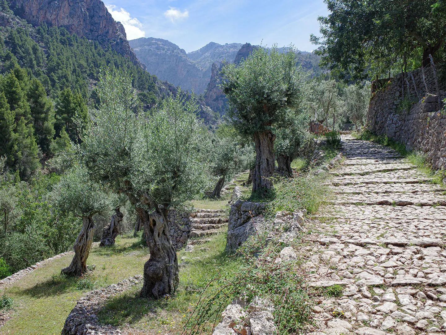
The GR221 follows restored sections of Mallorca’s old pedra en sec path network: dry-stone mule tracks, terraces, stone steps and estate routes once used to link Tramuntana villages with agricultural land, charcoal pits and snow houses. The Consell de Mallorca has restored and waymarked much of this network. In 2011, the Serra de Tramuntana dry-stone cultural landscape was inscribed as a UNESCO World Heritage Site, recognising the long human shaping of these mountains through terracing and water management.
Notable highlights
- Serra de Tramuntana UNESCO landscape: The whole route crosses Mallorca’s mountain backbone, recognised by UNESCO as a cultural landscape shaped by dry-stone terraces, paths and water systems.
- Pedra en sec trail heritage: Restored cobbled mule tracks, terrace walls, stone steps, snow houses and charcoal-burner clearings make the walking surface part of the route’s appeal.
- Valldemossa and Deià: Two classic Tramuntana villages; Valldemossa is associated with Chopin’s winter stay at the Royal Charterhouse, while Deià is linked with writer Robert Graves.
- Sóller and Port de Sóller: A useful pause point between demanding mountain stages, with orange and lemon groves and a historic narrow-gauge railway and tram connection to the port.
- Lluc Sanctuary: Mallorca’s major pilgrimage sanctuary, home to the venerated ‘La Moreneta’ Black Madonna, sits high in the central mountains near some of the tougher walking.
- Banyalbufar terraces: Sea-facing dry-stone vineyard terraces show the agricultural engineering the route is named for, including the Malvasia vine landscape.
Challenges to expect
This is a hard mountain route rather than a casual island walk. Expect long days on rough, loose and uneven stone, including restored cobbles that can be slippery when wet. Several stages involve steep ascents and descents, and some exceed 1,000 m of climbing. Summer heat and exposure can be severe; rare winter snow may affect higher passes. Refuges are limited and should be booked ahead.
HikeList Score
GR221 (Dry Stone Route) scored 89/100 on HikeList's trail-quality metrics.
See score breakdownHide breakdown
- Ideal length 96
- Balanced challenge 84
- Scenery & wildness 78
- Varied terrain 100
- Accommodation 92
- Food & support 88
- Path quality 98
- Season flexibility 89
Computed from length, challenge, scenery & wildness, terrain variety, accommodation, food & support, path quality and season flexibility.
 Spain
SpainShow more data Show less
- Mountainous
- Coastal
- Forest
- Limestone
- Scrub
- Agricultural Terraces
- Rocky
- Cobbled
- Stone
- Dirt
- Huts
- Hotels
- Guesthouses
- Hostals
- Family Friendly
- Pet Friendly
- Restrooms
- Water Sources
- Campsites
- Shelters
Download Our Full Guide to GR221 (Dry Stone Route) FREE!
Get our comprehensive guide to this hike for free. Save it for later reading or print out at home.
In these collections
Photos from hikers
Taken on the trail by people who've reviewed GR221 (Dry Stone Route).
GR221 (Dry Stone Route): The Complete Guide
 i
Image by Mark
i
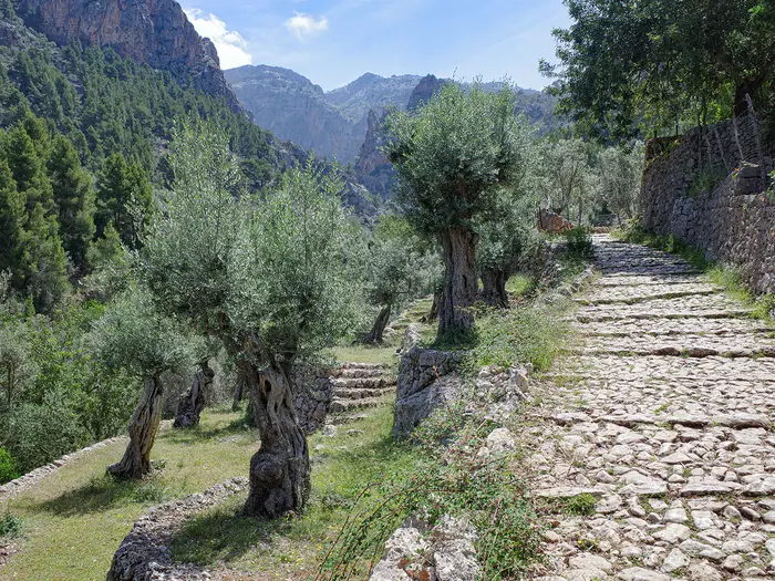
Image by Mark The GR221 is Mallorca’s great mountain traverse: a point-to-point walk through the Serra de Tramuntana from Port d’Andratx to Port de Pollença. It suits experienced walkers who want a hard, hut-and-village journey through dry-stone terraces, old mule tracks, limestone passes and historic mountain settlements.
The route follows the Ruta de Pedra en Sec, the restored dry-stone path network that gives the trail its name. Underfoot, expect cobbled empedrats, stone steps, loose limestone and steep zig-zags rather than smooth coastal strolling.
The best days link places such as Valldemossa, Deià, Sóller, Tossals Verds, Lluc and Pollença, with sea views, holm-oak woods, high reservoirs and the central Tramuntana ridges all part of the journey. The waymarked line reaches around 1,200 m at the Coll de ses Cases de sa Neu, while the island’s higher summits remain off-route.
This is not a casual sunshine walk: around 150 km, roughly 6,000 m of ascent, repeated long climbs and descents, slippery stone in wet weather and severe heat in summer all matter. Refuges also need booking ahead, so the logistics are as important as fitness.
This guide covers stages, daily planning, accommodation, food, transport, terrain and the common mistakes to avoid.
Stage-by-Stage Guide
The GR221 is usually walked south-west to north-east, with accommodation dictating the pace as much as fitness. Distances vary because the Ruta de Pedra en Sec includes variants, and some itineraries use Valldemossa, Banyalbufar or Pollença differently from the council’s signed stage structure. Treat the notes below as practical stage-planning guidance, not turn-by-turn navigation.
Stage 1: Port d'Andratx to Sant Elm / Estellencs
The opening stage leaves the south-west coast at Port d'Andratx and climbs into the first Tramuntana hills towards Sant Elm, with the route quickly becoming rougher and more mountainous than the harbour start suggests. This is an early introduction to the GR221’s typical footing: loose limestone, dry-stone paths, stone steps and exposed sections that feel much harder in heat than the map distance implies.
Sant Elm is the key early settlement, with views towards Sa Dragonera nature reserve. Many walkers use Sant Elm or the La Trapa area to break up the first part of the route, especially if arrival logistics make a full first mountain day unrealistic.
The La Trapa monastery estate is one of the main early landmarks, set above the coast with big views across the south-western Tramuntana. From here the route continues into more remote hill country before the practical stage end at Estellencs on many 8-day itineraries.
Food and water should be organised before leaving Port d'Andratx, then topped up where services are available in Sant Elm or at the end of the day. Do not assume reliable water on the hill sections; carry enough for a long, hot and exposed day. Opening hours and seasonal services should be checked before travelling.
Accommodation needs deciding in advance: Sant Elm/La Trapa works as a shorter first-stage option, while Estellencs is the longer onward target used by many practical itineraries. The refuge and village-accommodation chain on the GR221 is not something to improvise in peak walking periods.
For access, Port d'Andratx is reached from Palma by TIB bus 101/102 from Estació Intermodal. There is road access at the coastal settlements, but onward transport should not be assumed without checking current TIB timetables.
Navigation is generally by GR red-and-white waymarks and Ruta de Pedra en Sec signs, but the first day has enough route choices around Sant Elm and La Trapa to make a map or GPS track sensible. In July and August the exposure is a serious issue; start early, carry more water than usual and avoid committing to the full stage in extreme heat.
Stage 2: Estellencs to Esporles
This stage links two Tramuntana villages through the western part of the range, with a shorter distance than Stage 1 but the same rough mountain character. Expect dry-stone paths, stony tracks, woodland and repeated climbing and descending rather than steady valley walking.
The official main line runs inland from Estellencs to Esporles. Banyalbufar, with its sea-facing dry-stone vineyard terraces and historic Malvasia landscape, is associated with a coastal variant rather than the main stage, so it should be treated as an optional route choice rather than an automatic waypoint.
The walking is less about one single pass and more about moving through the cultural landscape the route is named for: terraces, walls, old mule tracks and cultivated slopes. Wet empedrats can be slippery, and loose limestone makes descents tiring even when the distance looks modest.
Food and water planning is straightforward at the village ends, but the middle of the stage should be treated as self-sufficient. Refill before leaving Estellencs and arrive in Esporles with enough margin if walking in warm weather. Village shops, bars and restaurants can have seasonal or irregular hours, so this should be checked before travelling.
Esporles has village accommodation options used by GR221 walkers. Book ahead, especially if linking the stage with refuge nights later in the route.
Road access is available at Estellencs and Esporles, and TIB mountain buses serve villages along the range, but timetables vary and should be checked before relying on them for a start, finish or bail-out. This is a useful stage to shorten or alter if weather, heat or accommodation availability forces a change.
Navigation is usually clear where the GR221 is signposted, but take care at junctions where variants split. If choosing the Banyalbufar coastal option, make sure the accommodation and onward stage plan still connect cleanly with Esporles or the next day’s route.
Stage 3: Esporles to Valldemossa
This is a shorter stage in distance, but it should not be dismissed as an easy rest day. The path still uses rough stone surfaces and hill terrain, with the usual Tramuntana mix of woodland, terraces and rocky ground.
Valldemossa is one of the most useful and attractive overnight stops on the practical GR221 itinerary. It is a classic mountain village of cobbled lanes, associated with Frédéric Chopin and George Sand’s winter at the Reial Cartoixa.
The official numbered stage structure does not always match the way walkers divide the route: the council stage from Esporles continues towards Can Boi near Deià, while Valldemossa sits on a widely walked practical itinerary and a signposted variant. This matters when booking accommodation and when following waymarks, because not every itinerary description will use the same stage break.
Food and water are best handled in Esporles before departure and Valldemossa on arrival. Carry enough water for the full walking time between villages; do not rely on finding an open service mid-stage unless specifically planned. This should be checked before travelling.
Valldemossa has village accommodation rather than a council refuge listed as the stage-end refuge chain. It is a popular place, so booking well ahead is sensible.
Road access and bus options exist in the broader Tramuntana village network, but current TIB timetables should be checked before planning a section walk or bail-out. This is one of the more practical places to adjust the itinerary because the stage is shorter and ends in a substantial village.
Navigation needs attention where the Valldemossa variant separates from the council’s main stage logic. A current map or GPS track helps avoid unintentionally committing to the longer continuation towards Deià.
Stage 4: Valldemossa to Deià / Refugi de Can Boi
The stage from Valldemossa to Deià is a classic central-western Tramuntana day, moving between two of the route’s best-known mountain villages. It is not long by distance, but the terrain is demanding: rough limestone, stone-built paths, steep sections and descents that can be slow on tired legs.
The key attraction is the high, dry-stone mountain landscape above the coast, with views opening towards the sea where the route allows. Deià itself is a compact stone village set on the slope above the Mediterranean and long associated with the writer Robert Graves, who lived and is buried here.
The practical stage end is Deià or Refugi de Can Boi near Deià. Can Boi is part of the GR221 refuge chain and should be booked through the Consell de Mallorca system well in advance.
Food and water are available to plan around at Valldemossa and Deià, but the walking between them should be treated as self-contained. Carry a full day’s water in hot weather, and do not assume that any intermediate option will be open. Check current opening times before travelling.
Accommodation at Deià can be in the refuge or in village guesthouses/hotels, depending on availability and budget. Refuge meals are usually part of the practical GR221 rhythm, but reservations are essential and should not be left until arrival.
Road access at Valldemossa and Deià makes this a possible section-walk day, though transport timings need checking. TIB mountain services can be useful along the range, but do not plan a tight connection without confirming current schedules.
Navigation is generally manageable on the signed GR221/variants, but pay attention at village exits and on stony descents. Wet cobbles and polished stone steps can be very slippery, especially after rain.
Stage 5: Deià to Port de Sóller / Refugi Muleta
This stage carries the route from Deià into the Sóller area, one of the most useful logistical hubs on the GR221. The walking remains stony and undulating, with dry-stone paths, terraces and woodland before the route reaches the fertile Sóller valley and Port de Sóller.
Sóller and Port de Sóller are a natural pause point between the western villages and the harder central mountain stages. The valley is known for orange and lemon groves, and the historic narrow-gauge railway and vintage tram connect Palma, Sóller and the port.
The usual GR221 overnight target is Refugi Muleta above Port de Sóller. This gives good positioning for the next day’s long climb out of the Sóller valley towards the high mountains.
Food and water logistics are easier here than on the more remote stages because Deià, Sóller and Port de Sóller all sit on the practical itinerary. Even so, carry enough water for the walking day and avoid depending on a specific café or shop without checking opening hours.
Accommodation choices range from the council refuge at Muleta to hotels and guesthouses in Sóller or Port de Sóller. The refuge must be booked ahead through the Consell de Mallorca booking system; private accommodation in the Sóller area can also fill quickly in the main walking seasons.
Public transport options are strongest here. The Sóller train and tram provide a useful link with Palma and Port de Sóller, and the wider TIB network gives options for shortening, joining or leaving the route. Check current timetables before relying on any connection.
Navigation is usually straightforward where the route approaches settled areas, but urban edges and variant lines can still cause confusion. Make sure the end point is clear: Sóller town, Port de Sóller and Refugi Muleta are close in itinerary terms but not identical for accommodation or the next morning’s start.
Stage 6: Sóller to Refugi de Tossals Verds via Coll de l'Ofre and Cúber
This is one of the major mountain days of the GR221 and should be treated seriously. The stage climbs out of the Sóller valley through the Barranc de Biniaraix, a long dry-stone ravine with sustained stone-stepped zig-zags, before reaching Coll de l'Ofre and the high reservoir landscape around Cúber.
The scenery becomes more alpine in feel here, with Cúber and Gorg Blau reservoirs set beneath the Puig Major massif. Puig Major itself is not on the GR221 and is a closed military zone; the route passes below the high summits rather than climbing them.
The terrain is hard on both ascent and descent: stone steps, loose limestone, exposed tracks and little genuinely flat walking. In warm weather this is a long, sweaty day; in poor weather the higher ground can feel remote and serious.
Food and water should be organised before leaving Sóller or Port de Sóller. Do not rely on resupply between the valley and Tossals Verds unless a specific, current option has been planned. Carry enough water for a long mountain stage, especially from spring into autumn.
Refugi de Tossals Verds is the key overnight point and must be booked in advance. Because the stage ends away from a large village, arriving without a reservation is a poor strategy.
Transport and road access are much less flexible once committed to the high central section, although the Cúber area sits on the mountain-road corridor and TIB mountain buses can be useful for some itineraries. Current bus schedules and stopping points should be checked before planning any bail-out around Cúber.
Navigation is generally aided by GR waymarks, but this is not a stage for casual map-reading. Carry a reliable map or GPS track, watch for variant choices, and avoid starting late. Rare winter snow can affect the high passes, and summer heat or fire-risk closures should be checked before travelling.
Stage 7: Refugi de Tossals Verds to Lluc / Refugi de Son Amer
This stage continues through the central Serra de Tramuntana and crosses the highest ground reached by the official GR221. The key high point is Coll de ses Cases de sa Neu, a pass a little over 1,200 m, named for the old snow houses that are part of the route’s dry-stone heritage.
The walking is rugged and sustained, with rocky paths, dry-stone surfaces, woodland and exposed mountain sections. Although the GR221 is not an alpine route, this is still a proper mountain stage and conditions can change quickly on the higher ground.
The route finishes in the Lluc area, close to Santuari de Lluc, Mallorca’s principal pilgrimage sanctuary and home to the venerated La Moreneta Black Madonna. Refugi de Son Amer is the practical GR221 refuge for the stage end.
Food and water are limited to what is available at the refuges and at Lluc, so leave Tossals Verds carrying what is needed for the full day. Refill before setting out and do not depend on water en route. Refuge meal arrangements and any services at Lluc should be checked when booking.
Accommodation should be reserved at Refugi de Son Amer or in the Lluc area before starting this stage. This part of the route depends heavily on the refuge chain, and options are not as flexible as in Sóller or Valldemossa.
Road access improves again around Lluc, and TIB mountain services can be useful for section walkers or for leaving the route. Timetables should be checked before travelling, especially outside the main season.
Navigation is important around the high-pass section and any variant over similar high ground. Stay alert in mist, after rain and in winter conditions. Wet empedrats and limestone slabs can be slippery, while rare winter snow can make the high passes much more serious.
Stage 8: Lluc to Pollença / Port de Pollença
The final practical stage leaves the central mountains and heads towards Pollença, with many walkers treating Pollença or Refugi del Pont Romà as the last overnight before continuing to Port de Pollença. The stage list often compresses this into one long finish, but the end-point choice matters for distance, accommodation and transport.
The walking gradually loses the high-mountain feel but remains rough underfoot in places, with stony paths and dry-stone sections continuing towards the north of the island. Do not assume the last day is simply an easy road walk to the coast; tired feet still have to deal with hard stone surfaces.
Pollença is the main cultural stop near the end of the route, with the Pont Romà on the edge of town and the Calvari steps rising through the old town. From Pollença, the final section drops towards Port de Pollença on the bay.
Food and water planning is easier once Pollença is reached, but leave Lluc with enough supplies for the walking day. If continuing all the way to Port de Pollença, allow for the extra time and heat exposure of the final approach to the coast. Opening hours and seasonal services should be checked before travelling.
Accommodation options include Refugi del Pont Romà at Pollença and hotels or guesthouses in Pollença or Port de Pollença. If the itinerary finishes at the port on the same day, make sure the booking matches the actual end point rather than assuming Pollença and Port de Pollença are interchangeable.
Transport from the finish is by bus rather than train. TIB buses 301/302 link Port de Pollença back to Palma, and bus 322 runs to Alcúdia with onward airport connections; current timetables should be verified before relying on them.
Navigation is usually less complex near the end, but pay attention where the route passes through Pollença and continues towards the coast. The final day can be hot and exposed, so an early start still makes sense in warm weather, even though the route is leaving the highest mountains behind.
Recommended Itinerary
The GR221 is usually planned around the refuge and village chain rather than purely by distance. The official main route is 150.1 km, but practical itineraries vary because of variants and village access, so treat the figures below as planning distances and check official mapping before booking accommodation.
Standard 8-day itinerary
This is the common fit-walker schedule: long enough to use the main accommodation hubs, but still demanding because several days involve rough limestone, dry-stone steps and sustained ascent/descent.
| Day | From | To | Approx. distance | Why this stage makes sense | Services/accommodation notes |
|---|---|---|---|---|---|
| 1 | Port d'Andratx | Sant Elm / Estellencs | 21 km | A committed opening day from the south-west coast into the first Tramuntana hills. It gets the route properly underway, but it is one of the days where exact stopping point matters. | Sant Elm and La Trapa are the early-stage refuge/accommodation options; Estellencs has village accommodation. Book ahead and check the exact route line before fixing this night. |
| 2 | Estellencs | Esporles | 14 km | A manageable second day after the long start, continuing through the western Serra de Tramuntana without needing to overreach. | Esporles has village services and accommodation. Banyalbufar is associated with a coastal variant, not the direct main stage. |
| 3 | Esporles | Valldemossa | 10 km | A shorter stage that helps absorb fatigue before the rougher central sections. It also makes practical use of Valldemossa as an accommodation hub. | Valldemossa has hotels, hostals and guesthouses. The official numbered stage pattern and the widely walked practical itinerary do not always align exactly here, so check the route variant used. |
| 4 | Valldemossa | Deià / Refugi de Can Boi | 14 km | A classic village-to-village Tramuntana day, with enough distance to feel substantial without pushing into the Sóller valley too soon. | Refugi de Can Boi near Deià is a key GR221 refuge and should be booked through the Consell de Mallorca system. Deià also has village accommodation. |
| 5 | Deià | Port de Sóller / Refugi Muleta | 13 km | A shorter day into the Sóller area, useful before the harder mountain stage that follows. It also allows time to resupply or reorganise kit. | Sóller and Port de Sóller have the best mid-route services on the trail. Refugi Muleta above Port de Sóller is the usual refuge stop. |
| 6 | Sóller | Refugi de Tossals Verds via Coll de l'Ofre / Cúber | 20.5 km | One of the major mountain days: the route climbs out of the Sóller valley through the Barranc de Biniaraix area towards Coll de l'Ofre and the high reservoir country. | This is not a good day to start late, especially in heat. Refugi de Tossals Verds is a key booked refuge; carry enough food and water for a long, exposed mountain stage. |
| 7 | Refugi de Tossals Verds | Lluc / Refugi de Son Amer | 14 km | A demanding central stage despite the moderate distance, crossing high Tramuntana terrain near the route’s highest point around Coll de ses Cases de sa Neu. | Refugi de Son Amer near Lluc is the main overnight stop. Lluc also gives access to the Santuari de Lluc area. |
| 8 | Lluc | Pollença / Port de Pollença | 19.5 km | A long final day out of the central mountains towards Pollença and the north coast. Strong walkers may continue to Port de Pollença; others may prefer to stop at Pollença/Pont Romà. | Refugi del Pont Romà is on the edge of Pollença and is useful if splitting the finish. If continuing to Port de Pollença, allow for the full distance and onward transport. |
Slower variant: 9–10 days
A slower schedule suits walkers who want shorter days, more margin for heat, or less pressure around the rough stone descents. It is also sensible if refuge availability forces a less direct booking pattern.
Good places to add time are:
- Sant Elm or La Trapa near the start — useful for breaking up the first long push from Port d'Andratx towards Estellencs. Exact distances depend on the variant used; check official mapping before booking.
- Sóller or Port de Sóller — the best mid-route place for a rest or resupply night before the demanding Sóller–Tossals Verds mountain stage.
- Pollença / Refugi del Pont Romà — a practical way to avoid making Lluc to Port de Pollença one long final day. The final drop to Port de Pollença should be checked on current mapping and transport timetables before fixing onward travel.
Faster variant: 7 days
A 7-day traverse is only for strong, efficient mountain walkers carrying a light pack or using luggage transfer. The obvious compression is in the western half, where the Esporles–Valldemossa and Valldemossa–Deià sections are shorter on paper, but combining stages still creates a long day on rough, often slippery stone.
Do not compress the Sóller–Tossals Verds and Tossals Verds–Lluc section casually. Those central days include the biggest mountain terrain, high passes around 1,200 m, exposed ground and limited intermediate accommodation. Refuge availability may also decide what is possible more than fitness does.
Planning the Route
The GR221 is best planned around accommodation first and daily distance second. The natural stopping points are the Tramuntana villages and the Consell de Mallorca refuge chain, so the route does not divide into completely flexible wild-camp-style stages.
Most walkers should allow 8–10 days. The council signs the main route as 9 stages, while many practical itineraries compress it into 8 by using the main village and refuge hubs. Strong walkers can go faster, but the rough empedrat stone paths, long descents and repeated climbing make a rushed schedule noticeably harder than the map distance suggests.
Choosing an itinerary length
| Itinerary style | Who it suits | Planning notes |
|---|---|---|
| 8 days | Fit, experienced hillwalkers carrying light packs or using luggage transfer | This is the common compressed schedule. Expect several full mountain days, especially through the central Tramuntana around Sóller, Cúber, Tossals Verds and Lluc. |
| 9 days | Most independent walkers | Closest to the way the route is naturally staged by refuges and villages. Gives more margin for heat, rough ground and slower descents. |
| 10 days | Walkers wanting shorter days, village time or a less pressured refuge schedule | Useful if adding a variant such as Banyalbufar, taking more time around Sóller, or avoiding a long final push to Port de Pollença. |
A very fast traverse is possible for strong walkers, but it removes much of the route’s practical resilience. Missed refuge check-ins, heat, sore feet on limestone and limited accommodation flexibility can quickly become bigger problems than the walking itself.
Stage planning and accommodation hubs
The route is easiest to plan from south-west to north-east: Port d’Andratx, Sant Elm or La Trapa, Estellencs, Esporles, Valldemossa, Deià / Refugi de Can Boi, Sóller / Port de Sóller / Refugi Muleta, Refugi de Tossals Verds, Lluc / Refugi de Son Amer, Pollença / Refugi del Pont Romà, then Port de Pollença.
Refuges are the key constraint. The Consell de Mallorca refuges are basic shared dormitory accommodation with set meals, and they must be booked ahead through the official booking system; bookings open roughly 130 days in advance. In the busier walking seasons, build the itinerary around confirmed beds rather than assuming the preferred stage order will be available.
Hotels, hostals and guesthouses in places such as Estellencs, Esporles, Valldemossa, Deià, Sóller and Port de Sóller give more flexibility than the mountain refuges. They can also help split or soften the route, especially through the western and central sections where villages are close enough to create alternative pacing.
Variants, shortcuts and extensions
Do not treat every quoted distance for the GR221 as identical. The official Consell de Mallorca main route is 150.1 km, while walked itineraries commonly come out at roughly 138–159 km depending on variants, village access and exact start or finish choices.
Banyalbufar is best understood as a coastal variant rather than the official main line between Estellencs and Esporles. It is a worthwhile option if the itinerary allows it, but it changes the day’s shape and should be planned deliberately rather than assumed as part of the standard stage.
Valldemossa appears on widely walked practical itineraries and a signposted variant, although the official numbered staging runs Esporles to Can Boi near Deià. For most walkers using village accommodation, Valldemossa remains a sensible overnight stop and planning hub.
The high mountains above the GR221 should not be confused with the route itself. Puig Major and Puig de Massanella overlook the trail but are not on the official GR221 line; Puig Major is a closed military zone.
Section hiking and bail-out points
Section hiking is practical because the route passes several villages and transport-linked points, but it still needs timetable planning. Neither Port d’Andratx nor Port de Pollença has a train station, so the route ends rely on buses.
From Palma, TIB buses 101 and 102 serve Port d’Andratx. From Port de Pollença, TIB buses 301 and 302 return towards Palma, while bus 322 links to Alcúdia and onward airport connections. Current TIB timetables should be checked before travelling.
Sóller is the most useful mid-route access point. The historic train links Palma with Sóller, the tram continues to Port de Sóller, and TIB mountain buses including 354 and 203 serve villages along the Serra de Tramuntana. This makes Sóller a practical place to start, stop, rest, replace kit or leave the route if needed.
Food, water and daily self-sufficiency
Food planning is straightforward in the villages but less flexible on the mountain stages. Refuge stays usually include set breakfast and dinner, while village nights give access to local shops, cafés or restaurants depending on opening times and season.
Carry enough food for each walking day rather than relying on finding services between stage ends. The central mountain stages around Coll de l’Ofre, Cúber, Tossals Verds, Coll de ses Cases de sa Neu and Lluc are not places to discover that lunch or water planning was too optimistic.
Water matters as much as distance on this route. Heat and exposure can be severe, especially outside the best spring and autumn windows, and there is little flat walking where effort drops for long. Availability at accommodation and villages should be used to start each day with enough water for the full stage; any assumed refill point on the trail should be checked before travelling.
Navigation and route choice
The GR221 is waymarked with red-and-white GR flashes, and the wider Ruta de Pedra en Sec network is signposted by the Consell de Mallorca. Even so, a map, guidebook or reliable GPS track is sensible because variants, village approaches and restored path sections can make route choice less obvious than a single-line trail on a map.
Navigation is especially important when leaving or entering villages, where side lanes and local paths can distract from the main line. It also matters in poor weather on higher ground, where the route crosses exposed passes and rough limestone rather than simple valley paths.
Weather, season and closures
The most practical seasons are roughly February to June and September to October. July and August should be avoided by most walkers because heat and exposure turn already hard stages into a much more serious undertaking.
Wet weather creates a different problem: the restored cobbled mule tracks and limestone can become slippery, particularly on steep descents. In winter, rare snow can affect the high passes, including the central mountain sections around 1,200 m.
Seasonal land-access restrictions, fire-risk closures and refuge availability should be checked before travelling. On the GR221, successful planning is mainly about securing beds, matching the stage length to heat and terrain, and keeping enough transport flexibility to adjust if the mountains or logistics do not cooperate.
Towns, Villages and Overnight Stops
Accommodation on the GR221 is a mix of Consell de Mallorca refugis and private hotels, hostals and guesthouses in the Tramuntana villages. The refugis are the backbone of many itineraries: they are basic shared-dormitory accommodation, usually with set breakfast and dinner, and must be booked ahead through the Consell de Mallorca booking system. Availability is a real constraint, especially on a refuge-to-refuge schedule.
Private accommodation gives more flexibility in places such as Estellencs, Esporles, Valldemossa, Deià and Sóller, but it can make stages uneven if the refuges are full. Luggage transfer is available from local operators for hikers using booked accommodation, but this should be arranged before travel rather than assumed on arrival.
Port d'Andratx
Port d'Andratx is the south-western harbour where the waymarked GR221 begins. It is a practical starting point rather than a mountain village: arrive with the first day already planned, because the route climbs away from the coast towards Sant Elm and the Tramuntana.
TIB buses 101 and 102 link Palma’s Estació Intermodal with Port d'Andratx in about an hour. Current timetables should be checked before travelling, particularly if arriving at Palma airport the same day.
Food and accommodation are available in the wider harbour area, but hikers should not leave first-day supplies to chance if starting early. Carry enough water and food for the opening stage, especially in warm weather.
Sant Elm
Sant Elm sits early in the route, before or around the La Trapa section, and is a useful first-night option on shorter opening itineraries. It also works as a staging point if the full Port d'Andratx to Estellencs day feels too long.
The area is important for access to La Trapa and for views towards Sa Dragonera, but for planning purposes its main value is that it can break up the demanding south-western start. Accommodation and food options should be checked before booking a short first stage, as relying on same-day availability is risky in season.
La Trapa and Refugi de La Trapa
La Trapa is not a village but an important early refuge and landmark above the coast. It sits near the old monastery estate and can be used to break the first section if the refuge is open and available.
As with the other refugis, booking must be made in advance through the Consell de Mallorca system. Do not assume refuge meals, bed availability or access arrangements without checking current details before travelling.
There are no normal village services here, so arrive self-sufficient unless a booked meal arrangement is in place. This is a mountain stop, not a resupply point.
Estellencs
Estellencs is one of the first proper Tramuntana village overnight stops for walkers coming north-east from Port d'Andratx or Sant Elm. It is commonly used at the end of the opening stage on practical itineraries.
Accommodation is in private hotels, hostals or guesthouses rather than the main Consell refuge chain. Book ahead, because the village is small and a full GR221 schedule gives little margin if beds are unavailable.
Food and basic village services may be enough for an evening meal and next-day start, but opening hours and shop availability should be checked before relying on them. Carry trail food from the previous larger service point if walking outside the busiest season.
Banyalbufar
Banyalbufar is relevant if taking the coastal variant rather than staying strictly on the official main line between Estellencs and Esporles. It is known for its sea-facing dry-stone terraces, but it should be treated as an optional route choice, not an automatic overnight stop on the standard itinerary.
If using this variant, check accommodation and onward route logistics carefully before committing. It can be a good place to slow the early stages, but it may also change stage lengths and transport assumptions.
Food and village services should be confirmed before travel. Do not plan a tight resupply strategy around a variant village without checking what is open on the day.
Esporles
Esporles is the usual overnight after the Estellencs stage on many itineraries. It is a practical village stop before the route turns towards Valldemossa and the more famous central Tramuntana settlements.
Private accommodation is the normal option here. This makes Esporles useful when building an itinerary around a mix of guesthouses and refuges, especially if Consell refuge availability does not match the desired dates.
Expect village-level food and café/bar options rather than a large trail town. Shop and restaurant opening times should be checked, particularly for Sunday, holidays or out-of-season walking.
Valldemossa
Valldemossa is one of the most useful and popular overnight stops on the western half of the GR221. Although the official numbered stage arrangement differs from many practical walking itineraries, Valldemossa sits on the widely walked route pattern and is a natural stop between Esporles and Deià.
Accommodation is in private hotels, hostals and guesthouses. Demand can be high, so it is not a place to leave until late if the walking schedule depends on staying there.
For hikers, the advantage of Valldemossa is practical as much as cultural: it gives a proper village night before the traverse towards Deià. Food options are better than at isolated refuge stops, but next-day water and food should still be organised before leaving.
TIB mountain buses serve villages along the range, including useful bail-out or section-hiking links, but the exact route and timetable should be checked before relying on public transport from Valldemossa.
Deià and Refugi de Can Boi
Deià is a key GR221 overnight village and one of the classic stops on the route. The Consell-run Refugi de Can Boi is near Deià and is the main refuge option here.
Can Boi must be booked in advance through the Consell de Mallorca refuge system. Expect basic shared accommodation and set meals rather than hotel flexibility.
Private accommodation in Deià can be used instead, but it is likely to need early booking. This is not a place to arrive casually at the end of a long stage and expect an easy fallback.
Food and cafés are available in the village area, but hikers staying at the refuge should check what meals are included and what needs to be carried for the next day. Deià is a useful reset point before the walk towards Sóller and Port de Sóller.
Sóller
Sóller is the most significant mid-route service town on the GR221 corridor. It sits in the fertile Sóller valley and is a major planning point between the western village stages and the harder central mountain section towards Tossals Verds and Lluc.
Accommodation is private rather than refuge-based in the town itself. Sóller is useful for a rest night, laundry, food shopping and reorganising before the big climb through the Barranc de Biniaraix towards Coll de l'Ofre and Cúber.
Transport links are better here than almost anywhere else on the route. The historic narrow-gauge train links Palma and Sóller, and the vintage tram links Sóller with Port de Sóller. Current operating times and ticket details should be checked before building an itinerary around them.
TIB mountain bus services also make Sóller one of the best points for joining, leaving or shortening the route. Verify current timetables before relying on a same-day connection.
Port de Sóller and Refugi Muleta
Port de Sóller is the coastal overnight option paired with Sóller on many itineraries. The Refugi Muleta sits above Port de Sóller and is the main Consell refuge for this stage end.
Muleta is an important booked refuge because it sets up the following mountain day towards Tossals Verds via the Sóller valley, Barranc de Biniaraix, Coll de l'Ofre and Cúber. Book it early if following a refuge-based itinerary.
Port de Sóller has more services than the isolated mountain refuges, and the tram connection to Sóller can help with logistics. Even so, do not assume late-evening transport or food options without checking current times.
Cúber, Coll de l'Ofre and the approach to Tossals Verds
Cúber and Coll de l'Ofre are not overnight villages, but they are crucial planning points on the central mountain stage. The route climbs out of the Sóller valley through the Barranc de Biniaraix to Coll de l'Ofre and reaches the high reservoir landscape around Cúber before continuing towards Tossals Verds.
Treat this as a carry-through mountain section. There are no normal town services at the pass or reservoir, and the day is long, exposed and rough underfoot.
Water, food and weather judgement matter here. In summer heat or poor weather, the lack of easy services between Sóller/Port de Sóller and the refuge makes early starts and conservative pacing important.
Refugi de Tossals Verds
Refugi de Tossals Verds is one of the most important mountain refuges on the GR221. It sits in the central Tramuntana and breaks the demanding crossing between the Sóller side and Lluc.
This is a booked Consell refuge, not a village stop. Accommodation is basic shared dormitory style with set meals, and reservations should be made as soon as the booking window allows.
There are no normal shops or alternative services immediately at the refuge, so arrive with any specific snacks, medication or onward-day supplies already carried. If the refuge is full, the whole central section may need replanning rather than a simple late change.
Lluc and Refugi de Son Amer
Lluc is the main overnight hub after the central high section. The Santuari de Lluc is Mallorca’s principal pilgrimage sanctuary, and nearby Refugi de Son Amer is the usual GR221 refuge stop in this area.
Son Amer is part of the Consell refuge network and should be booked well ahead. It is a key logistical anchor because it sets up the final walking stage towards Pollença and Port de Pollença.
Food arrangements depend on the booked accommodation, so check what is included before arrival. Lluc is more substantial than an isolated pass, but hikers should still leave with enough food and water for the next day rather than relying on uncertain intermediate services.
TIB mountain buses serve parts of the Tramuntana range and can be useful for bailing out or section walking around Lluc. Current routes and seasonal timetables should be checked before travel.
Pollença and Refugi del Pont Romà
Pollença is the old town at the northern end of the main mountain traverse. It is a practical final overnight for hikers who do not want to continue straight to Port de Pollença at the end of the Lluc stage.
Refugi del Pont Romà, on the edge of Pollença by the Roman bridge area, is the penultimate refuge on the standard refuge chain and a useful booked stop before the final drop to the coast. As with the other Consell refuges, reserve ahead and check meal arrangements.
Pollença has the advantage of town services after several mountain stages. It is a sensible place to recover, sort onward transport and decide whether to finish the same day or leave the final stretch to Port de Pollença for the morning.
Port de Pollença
Port de Pollença is the northern coastal finish of the main GR221 route. It is the end point for most through-hikers and the place to plan onward travel back towards Palma or the airport.
TIB buses 301 and 302 run back towards Palma, and bus 322 links to Alcúdia for onward airport connections. Journey times are around 1.5 hours, but current timetables and connection times should be checked before booking flights or same-day onward travel.
Accommodation and food are available in the resort area, making it a comfortable finish if the schedule allows a night at the coast. If leaving the same day, build in time for the final walk from Pollença, bus frequency and any seasonal timetable changes.
Getting to the Start
By train
There is no train to Port d'Andratx, and no rail service to either end of the GR221. Rail is useful only in the middle of the route, where the historic Sóller train links Palma with Sóller and the tram continues to Port de Sóller.
For the start, treat Palma as the public-transport hub and continue by bus or taxi to Port d'Andratx.
By bus
The usual public-transport approach is via Palma. From Palma's Estació Intermodal at Plaça d'Espanya, take a TIB bus towards Port d'Andratx; routes 101 and 102 serve this corridor and the journey is around 1 hour.
Current TIB timetables should be checked before travelling, especially if arriving on Mallorca late in the day, on a Sunday or outside the main visitor season. Do not assume the last connection will allow enough time to reach Port d'Andratx, buy supplies and check into accommodation before starting the trail the next morning.
| Leg | Transport | Notes |
|---|---|---|
| Palma / Estació Intermodal → Port d'Andratx | TIB bus 101/102 | Main public-transport route to the trailhead; around 1 hour |
| Airport → Palma | Local onward transport to Estació Intermodal | This should be checked before travelling |
| Port d'Andratx → first walking stage | On foot | The waymarked GR221 starts in Port d'Andratx and heads north towards Sant Elm and the Tramuntana |
By car
Driving to Port d'Andratx is straightforward in principle, but it is rarely the cleanest option for a full traverse. The GR221 is a point-to-point route ending at Port de Pollença, so a car left at the start creates a long retrieval journey after finishing.
If using a car, check long-stay parking arrangements in Port d'Andratx before committing to the plan. Parking rules, availability and seasonal restrictions can change, and this should be checked before travelling.
A taxi can also be used from Palma or the airport if bus times do not work, particularly for late arrivals or groups. Pre-booking is sensible, and the fare should be agreed or checked before travel.
From the nearest airport
Mallorca's Son Sant Joan airport at Palma is the gateway for the GR221. From the airport, travel into Palma and continue from Estació Intermodal to Port d'Andratx by TIB bus 101 or 102.
Allow enough margin between landing and the onward bus. Flight delays, baggage collection and the transfer into Palma can easily make a same-day connection tight, and the walking start should not depend on catching the final bus of the day. This should be checked before travelling.
Where to stay before starting
The simplest pre-start night is in Port d'Andratx, so the first stage can begin without a morning transfer. This is especially useful because the opening day is not just a warm-up: the route quickly climbs away from the harbour towards Sant Elm and the Tramuntana.
Palma is a practical alternative if arriving late, if accommodation in Port d'Andratx is limited, or if a morning bus to the start fits better. The trade-off is that the first walking day begins with a transfer, so bus times need to be planned carefully.
Sant Elm or the La Trapa / Sant Elm refuge option may suit walkers adjusting the first stage, but this changes the logistics of starting from the official trailhead at Port d'Andratx. Any refuge night must be booked ahead through the Consell de Mallorca system, with availability checked well in advance.
Getting Home from the Finish
By train
There is no railway station at Port de Pollença or Pollença, so the GR221 finish is not a rail-linked trailhead. Plan to leave by bus, taxi or private transfer.
The historic Sóller train is useful for joining or leaving the route around Sóller and Port de Sóller, but it is not a practical onward connection from the official finish at Port de Pollença.
By bus
TIB buses are the main public transport option from the finish. From Port de Pollença, routes 301 and 302 run back towards Palma, while route 322 links Port de Pollença with Alcúdia for onward travel to the airport. The journey back towards Palma or the airport area is roughly 1.5 hours, depending on the service and connections.
Timetables are route- and season-dependent, and evening services may not suit a late finish after the final walk from Pollença to Port de Pollença. Check current TIB times before booking flights, airport transfers or same-day onward travel.
If returning to the start at Port d'Andratx, the simplest public-transport plan is usually to travel back via Palma, then use the TIB 101/102 service from Palma to Port d'Andratx. This adds another connection, so allow a generous margin.
By car/taxi
A taxi or pre-booked transfer is the simplest door-to-door option from Port de Pollença, especially if finishing late, carrying heavy luggage, or travelling as a small group. Availability and current prices should be checked before travelling, particularly outside the main holiday season or late in the day.
Because the GR221 is a point-to-point route, leaving a car at the start in Port d'Andratx creates a long retrieval journey from the north of the island. If using a hire car, it is usually more practical to collect it after finishing, or to arrange transport at both ends rather than trying to shuttle between trailheads on the final day.
From the nearest airport
Mallorca's airport is Son Sant Joan, near Palma, and it is the main gateway for the GR221. From Port de Pollença, use TIB buses back towards Palma, or bus 322 to Alcúdia with onward airport connections.
Do not plan a tight same-day flight after the final stage unless the bus times have been checked carefully. The last walking day can still be hot and tiring, and delays on the trail, missed connections or reduced evening services can make a late departure stressful.
Where to stay at the finish
The finish area gives two practical options: stay in Port de Pollença at the coast, or stop in Pollença after reaching the Pont Romà area and complete the final drop to the port separately. Pollença also has the Refugi del Pont Romà on the edge of town, while Port de Pollença has the convenience of finishing directly by the bay and being close to onward buses.
Staying overnight at the finish is the safer choice if the final stage from Lluc is being walked in full, if travelling in hot weather, or if onward transport depends on a specific bus or flight. Book accommodation ahead in busy walking periods and check the next day's TIB timetable before committing to early departures.
Which Direction Should You Walk?
Standard direction: Port d'Andratx to Port de Pollença
The normal and most practical direction for the GR221 is south-west to north-east, starting at Port d'Andratx and finishing at Port de Pollença. This is the direction used by the official main route description and by most practical itineraries, so stage planning, refuge nights and guidebook-style schedules tend to feel most natural this way.
It also gives a sensible progression. The route begins with coastal and lower Tramuntana walking around Port d'Andratx, Sant Elm and La Trapa, then works through the village stages of Estellencs, Esporles, Valldemossa, Deià and Sóller before reaching the harder central mountain section around Coll de l'Ofre, Cúber, Tossals Verds, Coll de ses Cases de sa Neu and Lluc.
That build-up matters. The central stages are rough, high and physically demanding, and reaching them after several days on the trail is generally preferable to meeting them almost immediately from the north.
Transport is straightforward in the standard direction. From Palma’s Estació Intermodal, TIB buses 101/102 run to Port d'Andratx; from Port de Pollença, TIB buses 301/302 return to Palma, with bus 322 to Alcúdia and onward airport connections also possible. Current TIB timetables should be checked before travelling.
The finish also works well psychologically. Dropping through Pollença and on to Port de Pollença gives a clear coastal end point on the bay, with transport and services available after the final walking day.
Walking the GR221 in reverse
Walking north-east to south-west, from Port de Pollença to Port d'Andratx, is possible as a route-planning choice, but it is less common. It reverses the usual rhythm of the trek: the Lluc, Tossals Verds, Cúber and Sóller mountain stages arrive early, before the easier village-and-coastal sections in the south-west.
Reverse direction does not make the GR221 significantly easier. The route has repeated steep climbs and descents whichever way it is walked, and the rough limestone, restored cobbled mule tracks and stone steps remain hard underfoot in both directions. Some walkers prefer climbing steep stone zig-zags rather than descending them, but the GR221 contains enough ascent and descent that no direction avoids the main physical demands.
Accommodation also needs more care in reverse. Refuges such as Pont Romà, Son Amer, Tossals Verds, Muleta and Can Boi can still be used if the dates line up, but the standard stage flow is less intuitive when planned backwards. Since council refuges must be booked ahead through the Consell de Mallorca system, direction should be chosen before making reservations.
Transport is still workable in reverse: buses link Palma with Port de Pollença, and Port d'Andratx is connected back to Palma by TIB bus 101/102. However, the standard direction is slightly cleaner for most walkers because it follows the established start-to-finish logic of the route.
Weather, heat and exposure
There is no strong direction-based weather advantage that should decide the route. The main weather issue on the GR221 is season and heat exposure, not whether the route is walked north-east or south-west.
In warm conditions, exposed climbs and dry stone surfaces can feel severe in either direction. February to June and September to October are the most practical walking windows; July and August heat should be avoided by most long-distance walkers.
Recommendation
Walk the GR221 in the standard direction: Port d'Andratx to Port de Pollença. It matches the official route, fits the usual refuge and village sequence, gives a better build-up towards the central mountains, and provides a satisfying coastal finish at Port de Pollença.
Reverse direction is mainly worth considering if accommodation availability forces it, or if transport plans work unusually better from the north. For most independent hikers booking refuges and walking the full traverse, south-west to north-east is the more practical choice.
Accommodation Along the Route
Accommodation on the GR221 is a mix of Consell de Mallorca refugis and village-based hotels, hostals and guesthouses. It is very workable as an accommodation-to-accommodation trek, but it is not a route where you should simply arrive and look for a bed each evening.
The key constraint is the refuge chain. Can Boi near Deià, Muleta above Port de Sóller, Tossals Verds, Son Amer near Lluc and Pont Romà at Pollença are the main council-run mountain refuges used by GR221 walkers, with La Trapa / Sant Elm relevant at the start of the route. These refuges are basic shared-dorm accommodation with set breakfast and dinner, and must be booked through the Consell de Mallorca booking system; bookings open roughly 130 days ahead.
Village accommodation gives more flexibility in Estellencs, Esporles, Valldemossa, Deià, Sóller and Port de Sóller. Sóller / Port de Sóller is the strongest mid-route accommodation hub and the best place to add a rest night, shorten a day or recover after the early stages before the harder central mountain section.
Best overnight stops and accommodation availability
| Place | Accommodation level | Best for | Notes |
|---|---|---|---|
| Port d'Andratx | Good | Pre-walk night before starting | The waymarked route begins here. Staying the night before avoids a rushed transfer from Palma on the first walking morning. |
| Sant Elm / La Trapa | Limited | Shortening the first stage; early refuge-style stop | Useful if not pushing through towards Estellencs on day one. La Trapa / Sant Elm is part of the refuge picture at the start, but availability should be checked before building an itinerary around it. |
| Estellencs | Limited to moderate | Standard early-stage village stop | A practical overnight after the first long section from Port d'Andratx / Sant Elm. Book ahead, especially in the main walking seasons. |
| Banyalbufar | Limited to moderate | Coastal variant or optional detour | Banyalbufar sits on a coastal variant rather than the official main Estellencs–Esporles line. Use it only if the itinerary deliberately takes that variant. |
| Esporles | Moderate | Breaking the western section into manageable days | A useful village stop between Estellencs and Valldemossa / Deià. Accommodation should still be booked in advance rather than left to chance. |
| Valldemossa | Good | Village stay; flexible itinerary between Esporles and Deià | Valldemossa is widely used on practical GR221 itineraries and works well for walkers who want a hotel or guesthouse night before continuing to Deià. |
| Deià / Refugi de Can Boi | Good but high-demand | Classic GR221 overnight; refuge or village accommodation | Can Boi is the key refuge for this section. Deià also has village accommodation, but demand can be strong; book early. |
| Sóller / Port de Sóller / Refugi Muleta | Good | Rest day, resupply, transport connections, flexible lodging | The strongest mid-route base. Muleta is the GR221 refuge above Port de Sóller, while Sóller and Port de Sóller offer the broadest practical choice before the central mountains. |
| Cúber / Coll de l'Ofre | None | Day passage only | This is mountain terrain between Sóller and Tossals Verds, not an overnight accommodation hub. Plan the Sóller–Tossals Verds stage carefully. |
| Refugi de Tossals Verds | Limited | Essential central-mountain overnight | One of the most important bookings on the route. There is no comparable village choice at this point, so secure the refuge before fixing the surrounding stages. |
| Lluc / Refugi de Son Amer | Limited to moderate | Overnight after Tossals Verds; access to Santuari de Lluc | Son Amer is the main GR221 refuge near Lluc. This is another key booking before the final approach to Pollença. |
| Pollença / Refugi del Pont Romà | Good | Final GR221 overnight before Port de Pollença | Pont Romà sits on the edge of Pollença and is the penultimate refuge on the standard route. Pollença is a sensible final inland stop before the bay. |
| Port de Pollença | Good | Finish-night stay and onward travel | The main route finishes on the north coast. Staying here makes the final day less rushed before returning towards Palma. |
Booking strategy
Book the refuges first, then fit hotels and guesthouses around them. Tossals Verds, Son Amer, Muleta, Can Boi and Pont Romà are the backbone of many itineraries, and a single unavailable refuge can force a major reshuffle of the walking schedule.
For fixed-date trips, secure accommodation before committing to flights or non-refundable transfers. Spring and autumn are the best walking seasons, so availability can tighten at exactly the times when conditions are most suitable. Weekends and holiday periods should be treated as higher-risk for last-minute bookings.
Refuge meals are set rather than à la carte hotel dining. Check current booking conditions, meal arrangements and arrival requirements when reserving, as details can change.
Inn-to-inn walking and luggage transfer
The GR221 works well for inn-to-inn walkers who are comfortable mixing hotels, hostals, guesthouses and dormitory refuges. It is less straightforward for walkers who want private rooms every night, because the central mountain section relies heavily on refuges rather than villages with wide accommodation choice.
Luggage transfer between accommodations is available from local operators and can make the route much easier under hot conditions or on the rough restored-stone surfaces. It is particularly useful if staying in village accommodation around Valldemossa, Deià, Sóller and Port de Sóller, then linking into the refuge chain.
Awkward gaps can sometimes be solved by using local transfers or public transport to move between a trail point and an overnight base, especially around Sóller / Port de Sóller. Any transfer-based itinerary should be checked before travelling, as timetables, operator availability and seasonal services can change.
Where accommodation is most limited
The main accommodation pinch points are the refuge-dependent mountain sections: Muleta to Tossals Verds, Tossals Verds to Son Amer, and Son Amer / Lluc towards Pollença. These are not places to improvise at the end of the day.
There is no accommodation to rely on at Cúber, Coll de l'Ofre or Coll de ses Cases de sa Neu. Treat these as through-walking sections and carry enough food, water and daylight margin for the full stage.
If the preferred refuge dates are full, the safest solution is usually to shift the whole itinerary rather than over-stretch a day across rough limestone and steep dry-stone paths. The GR221’s accommodation logistics are part of the challenge; plan them with the same care as the walking stages.
Camping and Wild Camping
The GR221 is best planned as a refuge-and-village route, not a camping trek. The practical overnight chain is built around Consell de Mallorca refugis such as Can Boi, Muleta, Tossals Verds, Son Amer and Pont Romà, plus hotels, hostals and guesthouses in villages including Estellencs, Esporles, Valldemossa, Deià, Sóller, Lluc and Pollença.
Carrying camping gear is usually a disadvantage on this route. The trail has repeated steep climbs and descents, rough limestone, slippery restored cobbles and long exposed sections where extra pack weight makes the walking noticeably harder, especially in warm weather.
Campsites on or near the route
There is no dependable campsite-to-campsite structure on the GR221 comparable to the refuge network. Do not build an itinerary around formal campsites unless each night has been checked and booked locally before travelling.
Where an authorised campsite or other camping-style accommodation is available off-route, factor in the extra distance, road access and transport carefully. The route’s natural stopping points are the signed stage ends and mountain refuges, so any camping-based plan may involve detours, taxis or bus links rather than simply pitching beside the trail.
Wild camping
Wild camping should not be treated as a normal or reliable option on the GR221. Much of the route passes through a sensitive mountain cultural landscape of dry-stone terraces, woodland, farms, estates, refuges and village approaches, and access rules can vary by area and season.
Do not pitch on private land, near refuges, in cultivated terraces, beside reservoirs, on historic dry-stone structures or anywhere that would obstruct paths or estate tracks. If permission is not explicit, assume camping is not allowed. Local rules, any temporary restrictions and fire-risk closures should be checked before travelling.
Fire, heat and seasonal risk
Open fires are inappropriate on this route. The Serra de Tramuntana can be very dry, exposed and hot, and seasonal fire-risk restrictions may apply. Use only authorised cooking facilities where permitted, and check current rules before relying on a stove outside formal accommodation.
July and August are particularly poor months for a camping attempt. Heat, limited shade, heavy water carries and high fire risk make the route harder and less forgiving; spring and autumn are the sensible seasons for most walkers.
Water and camping logistics
Water planning is one of the main problems with camping on the GR221. Potable water away from villages, refuges and staffed accommodation should be treated as uncertain, and reservoirs such as Cúber should not be assumed to provide usable drinking water.
Carry enough water for the full stage ahead, especially on exposed climbs such as the Sóller–Coll de l’Ofre–Tossals Verds section and on hot days. If using any off-route camping accommodation, confirm water availability before arrival.
Leave No Trace on the GR221
The route’s dry-stone paths, terraces, steps and walls are part of the reason for walking the GR221, and they are easily damaged by careless use. Never move stones to create a pitch, windbreak or cooking area, and do not camp on restored cobbled mule tracks or terrace edges.
Pack out all rubbish, avoid toileting near paths, buildings, water sources or agricultural land, and leave no visible trace of a stop. The safest and most responsible approach is to use booked accommodation and keep any rest stops brief, discreet and low-impact.
Food, Water and Resupply
The GR221 is not a wilderness route, but it is not a continuous village stroll either. Food is straightforward when stages end in settlements or booked refuges; the main planning risk is assuming there will be open shops, bars or cafés during the day, especially on the longer mountain sections.
Council refuges such as Can Boi, Muleta, Tossals Verds, Son Amer and Pont Romà are a major part of the logistics chain. Where booked, they provide basic accommodation with set breakfast and dinner, but packed lunches and exact meal arrangements should be checked when booking or at check-in.
General resupply strategy
Carry lunch and hill snacks every day unless a specific mid-stage stop has been checked in advance. The safest routine is to buy the next day’s lunch before leaving the previous village, particularly before the Sóller to Tossals Verds stage and the Tossals Verds to Lluc stage.
The best resupply opportunities are in the larger settlements on the route: Port d'Andratx, Sóller, Port de Sóller, Pollença and Port de Pollença. Smaller places such as Sant Elm, Estellencs, Esporles, Valldemossa and Deià can be useful, but opening hours, seasonal closures and Sunday or public-holiday trading should be checked before travelling.
Do not build the food plan around petrol stations or roadside services. The GR221 is primarily a village-and-refuge route, with long stretches on mountain paths, dry-stone tracks and passes where there may be no practical food option until the stage end.
Water planning
Start each stage with enough water for the whole walking day unless a refill point has been identified in advance. In cool spring or autumn conditions, many walkers will still want around 2 litres; in hot, exposed weather, and especially on the longer mountain stages, 3 litres or more may be needed.
Reliable water planning should be based on accommodation, refuges and settlements, not on natural sources. The route passes reservoirs such as Cúber and Gorg Blau and crosses mountain terrain, but these should not be treated as routine drinking-water sources. Any unplanned natural water should be filtered or treated, and availability should not be assumed.
Avoid July and August for this route if possible. The combination of limestone, restored stone paths, steep ascent and exposed Tramuntana terrain makes dehydration a serious planning issue, not just a comfort problem.
| Section | Food availability | Water availability | Notes |
|---|---|---|---|
| Port d'Andratx to Sant Elm / Estellencs | Start with supplies from Port d'Andratx. Sant Elm and Estellencs are the practical food stops or stage-end resupply points, depending on itinerary. | Fill before leaving Port d'Andratx. Refill at accommodation or services in Sant Elm / Estellencs where available. | Carry lunch and snacks from the start, especially if walking the longer first-day option through to Estellencs. |
| Estellencs to Esporles | Food is mainly at the start and end. Banyalbufar can add options only if taking the coastal variant. | Refill before leaving Estellencs; plan the next reliable water at Esporles unless a specific stop has been checked. | Do not assume mid-stage cafés or shops are open. The coastal variant changes logistics and should be planned separately. |
| Esporles to Valldemossa | Shorter stage with village resupply at each end. | Refill at Esporles and again at Valldemossa. | Still carry lunch or substantial snacks; short stages on the GR221 can feel slow because of the rough stone underfoot. |
| Valldemossa to Deià / Refugi de Can Boi | Food at Valldemossa before departure and in Deià / Can Boi at the end if booked. | Fill before leaving Valldemossa; refill at Deià or the refuge. | If using Refugi de Can Boi, dinner and breakfast are tied to the refuge booking. Packed lunch arrangements should be checked. |
| Deià to Sóller / Port de Sóller / Refugi Muleta | One of the easier resupply sections, with Deià, Sóller and Port de Sóller giving useful food options. | Refill at the start and again in Sóller / Port de Sóller or at Muleta if staying there. | This is the key place to stock up before the more committing central mountain stages. |
| Sóller to Refugi de Tossals Verds via Coll de l'Ofre and Cúber | Food should be bought before leaving Sóller / Port de Sóller. Do not rely on food between the valley and Tossals Verds. | Fill fully before leaving. The next reliable planned refill is at Refugi de Tossals Verds; do not rely on Cúber reservoir for drinking water. | This is a long, hard mountain day. Carry a full lunch, snacks and spare food in case heat, slow terrain or navigation delays extend the day. |
| Refugi de Tossals Verds to Lluc / Refugi de Son Amer | Food depends on refuge meals at Tossals Verds and services at Lluc / Son Amer. Carry lunch from the start. | Refill at Tossals Verds before leaving and again at Lluc / Son Amer. | Another mountain stage with limited mid-stage logistics. Do not leave Tossals Verds short of water. |
| Lluc to Pollença / Port de Pollença | Food at Lluc before departure and at Pollença / Port de Pollença at the end. | Refill at Lluc; next reliable planned water is in Pollença or Port de Pollença. | If continuing beyond Pollença to Port de Pollença the same day, treat it as a full walking day and carry enough food and water to finish comfortably. |
Terrain, Conditions and Difficulty in Practice
The GR221 is hard because of what happens underfoot as much as because of the distance. The route uses restored dry-stone mule tracks, cobbled empedrats, stone steps, rough limestone paths, woodland tracks and exposed mountain passes. The walking is rarely technically alpine, but it is continually uneven, loose or polished by use.
The cumulative effect is significant: around 6,000 m of ascent over the traverse, with several long days involving sustained climbing and descent. There is little truly flat walking, and progress is often slower than the map distance suggests.
Path surfaces
Expect a lot of stone. The route’s signature surfaces are dry-stone cobbles, terraces, steps and zig-zagging mule paths, especially through the Serra de Tramuntana’s older agricultural and mountain sections.
These surfaces are beautiful but tiring. Cobbles can be awkward under a full pack, limestone can roll underfoot, and the restored stone steps are hard on knees during long descents. Trekking poles are useful for the steeper downhill sections and for maintaining rhythm on loose ground.
Wet stone is a major practical hazard. The cobbled empedrats and limestone slabs can become slippery after rain, so a day that is straightforward in dry spring conditions can feel much slower and more cautious in poor weather.
Mud and bog are not defining features of this route. The main ground problems are hard stone, loose rock, heat-reflecting surfaces and steep gradients rather than saturated lowland terrain.
Climbs, descents and mountain sections
The route repeatedly drops into villages and valleys before climbing back onto ridges, cols and passes. This makes the GR221 more demanding than a single high-level ridge walk: the effort is cumulative, and legs do not get much recovery on flat ground.
The central mountain stages are the most serious. The climb out of the Sóller valley through the Barranc de Biniaraix towards Coll de l'Ofre, then onwards towards Cúber and Refugi de Tossals Verds, is one of the route’s key physical tests: long, stepped, steep and exposed in warm weather.
The stage between Tossals Verds and Lluc also feels more mountainous than the earlier village-to-village days. The waymarked GR221 reaches its highest point at Coll de ses Cases de sa Neu, a little over 1,200 m, and conditions here can be much cooler, windier and more exposed than on the coast.
The route does not summit Puig Major or Puig de Massanella. Both mountains dominate the central Tramuntana scenery, but they are off the official GR221 line; Puig Major is also a closed military zone.
Exposure, shade and heat
Exposure varies sharply. Some sections pass through holm-oak and pine woodland, while others cross open rocky cols, terraced slopes and sea-facing agricultural landscapes where shade is limited.
Heat is one of the biggest difficulty multipliers. In July and August, the combination of steep climbs, pale stone, limited shade and long distances can make the route much harder than its altitude suggests. The best walking windows are generally February to June and September to October, with spring and autumn offering the most reliable balance of temperature and daylight.
On hot days, the early start matters. Long climbs such as the approach to Coll de l'Ofre are much more manageable before the stone has absorbed the day’s heat.
Rain, wind and winter conditions
Rain changes the character of the route quickly. The cobbled mule tracks and limestone steps become slick, descents slow down, and polished stone in villages and on older paths needs care.
The GR221 is not a high-altitude alpine route, but the central Tramuntana is still mountain terrain. Wind, low cloud and poor visibility can affect the higher passes around Cúber, Tossals Verds, Coll de ses Cases de sa Neu and Lluc.
Snow is rare but possible in winter on the high passes. Winter walkers should treat the central stages as mountain days rather than Mediterranean strolls; current conditions should be checked before travelling.
Road, village and access sections
The main challenge is not road walking. There are inevitable paved sections through ports, villages and access points such as Port d'Andratx, Sant Elm, Estellencs, Esporles, Valldemossa, Deià, Sóller, Lluc, Pollença and Port de Pollença, but the route’s difficulty comes from the mountain paths between them.
Some stages feel more civilised because they start or finish in villages with services, yet the walking between those points can still be rough and slow. Do not judge a day solely by its distance: a 13–14 km stage on steep stone can take longer and feel harder than a much longer lowland walk.
Seasonal land-access or fire-risk closures can affect parts of the route. This should be checked before travelling.
What makes the GR221 harder in practice
| Factor | Practical effect |
|---|---|
| Rough limestone and cobbled empedrats | Slower pace, more ankle fatigue, higher slip risk when wet |
| Repeated steep climbs and descents | Around 6,000 m of total ascent; cumulative fatigue over several days |
| Long stone-stepped sections | Hard on knees and calves, especially with a full pack |
| Summer heat and exposure | Can turn moderate distances into serious days; July–August are best avoided |
| Limited flat ground | Few easy kilometres for recovery during the day |
| Refuge-based stages | Daily distances are partly dictated by accommodation, so stopping early is not always simple |
| Wet or windy mountain weather | Higher passes become slower and more serious, especially around the central Tramuntana |
Who will find it manageable
The GR221 suits walkers already comfortable with long mountain days, rough paths and multi-day pacing. Strong day-walkers can adapt well, provided they do not underestimate the repeated ascent, the hard stone surface and the need to manage heat.
It is not an ideal first long-distance hike for beginners. The route has villages and refuges, but the terrain between them is real mountain walking, and the harder stages leave little margin for poor footwear, late starts or underestimating water and sun exposure.
Weather and Best Time to Walk
The GR221 is best planned for spring and autumn, with the most reliable walking windows roughly February to June and September to October. These periods give a better balance of manageable temperatures, usable daylight and open services than high summer or the wetter, colder mountain months.
This is not a low-level coastal stroll: the route crosses the Serra de Tramuntana, reaches a little over 1,200 m at the Coll de ses Cases de sa Neu, and spends long periods on rough limestone, stone steps and restored dry-stone mule tracks. Weather affects both comfort and safety, especially on the exposed central stages around Sóller, Cúber, Tossals Verds and Lluc.
Best months: spring and autumn
Spring is one of the strongest periods for the full traverse. Temperatures are generally better suited to long climbs than in summer, and the route’s villages and refuges are practical to link together. Early spring can still bring unsettled mountain weather, so waterproofs and warm layers remain necessary.
Autumn, especially September to October, is also a good window. The severe summer heat has usually eased, but exposed climbs and dry sections can still feel hot, so early starts and a disciplined water plan remain important.
July and August: avoid for a full traverse
July and August are poor months for walking the whole GR221. The route is very exposed in places, with long climbs on stone and limestone that radiate heat. Shade is intermittent, and several stages involve sustained ascent where heat stress becomes a real risk.
If walking any section in summer, start very early, shorten the day, carry more water than in cooler months and avoid committing to the hardest central mountain stages in the heat of the day. Fire-risk or land-access restrictions can also affect plans in hot, dry periods; this should be checked before travelling.
Winter: possible, but more committing
The GR221 is not an alpine route, but winter should still be treated seriously. The high passes can see rare snow, and cold rain, wind or fog can make navigation and footing much harder. The stone-paved sections can become slippery when wet, particularly on restored cobbles, stone steps and limestone descents.
Winter daylight is shorter, which matters on longer stages such as the approaches to Tossals Verds and the Lluc–Pollença / Port de Pollença end of the route. A winter itinerary needs conservative stage lengths, warm layers, waterproofs, a headtorch and enough flexibility to wait out bad weather.
Refuge and village accommodation availability can vary outside the main walking periods. Refuge bookings should be made through the Consell de Mallorca system, and current opening, availability and meal arrangements should be checked before committing to winter dates.
Rain, wind, fog and trail surface
Rain has an immediate effect on this route because so much of the walking is on empedrats — restored dry-stone cobbled mule tracks — plus limestone, stone steps and loose rocky paths. Wet stone can be polished and slippery, and steep descents become slower than the distance suggests.
Fog and low cloud are most relevant on the higher central Tramuntana stages, where the route crosses exposed cols and passes. Carry reliable offline mapping or GPS, but do not rely on electronics alone; poor visibility can make waymarks harder to follow.
Strong wind is also a practical issue on exposed ridges, passes and open traverses. If the forecast is poor, the mountain stages around Coll de l'Ofre, Cúber, Tossals Verds and Coll de ses Cases de sa Neu deserve particular caution.
Daylight and daily timing
Even in the best seasons, the GR221 rewards early starts. Several days include long climbs, rough descents and little easy ground, so progress is slower than on smoother long-distance trails.
In hot weather, early starts reduce exposure on the major ascents. In winter or unsettled weather, they protect against finishing technical stone descents in failing light.
Accommodation and seasonal planning
The best walking months are also the periods when refuge beds and village accommodation can book up quickly. The Consell de Mallorca refuges must be reserved ahead, with bookings opening roughly 130 days in advance.
Do not leave accommodation to chance on a point-to-point itinerary. If refuges are full, village hotels, hostals or guesthouses may work on some stages, but this changes the day lengths and may require transfers or route adjustments.
Seasonal checks before setting off
Before fixing dates, check:
- current refuge availability and opening arrangements through the Consell de Mallorca booking system;
- TIB bus timetables if using public transport to reach, leave or shorten the route;
- any seasonal land-access or fire-risk restrictions;
- the mountain forecast before the central stages around Sóller, Cúber, Tossals Verds and Lluc.
For most hikers, the safest and most enjoyable plan is a full traverse in spring or autumn, avoiding the peak summer heat and treating winter as a more flexible, weather-dependent undertaking.
Safety Notes
The GR221 is a hard mountain walk rather than a casual island trail. Its main risks are rough stone underfoot, repeated steep climbs and descents, heat exposure, and the consequences of being delayed between booked refuges or village accommodation.
Emergency help and communications
In an emergency in Spain, call 112. Save the number before starting and know the name of the nearest village, refuge, pass or road access point for the stage being walked.
Do not rely on continuous mobile signal across the Serra de Tramuntana, especially on the more mountainous central stages around Cúber, Coll de l'Ofre, Tossals Verds, Coll de ses Cases de sa Neu and Lluc. Carry offline maps or a GPS track, plus enough battery for a full day; a paper map or guidebook remains useful if a phone fails.
Terrain hazards
The restored dry-stone mule tracks and cobbled sections are part of the character of the Ruta de Pedra en Sec, but they are also tiring and can be hazardous. Limestone, loose stones, stone steps and old cobbles become slippery when wet, and descents can be harder on knees and ankles than the distance suggests.
Footwear with good grip is strongly recommended. Trekking poles are useful on the long stepped climbs and descents, particularly on stages with over 1,000 m of ascent or descent.
Heat, sun and exposure
The route is very exposed and hot in summer, which is why July and August are best avoided. Even outside midsummer, long dry climbs can feel severe, especially where shade is limited on open terraces, rocky passes and reservoir approaches.
Start early on warm days, carry more water than would be needed for a shorter lowland walk, and avoid assuming there will be reliable water between villages or refuges. Natural water on the route should not be treated as safe to drink unless properly filtered or purified.
Cold, rain and high passes
Although the GR221 does not reach alpine altitude, the high point is a little over 1,200 m at Coll de ses Cases de sa Neu and the central Tramuntana can be cold, windy and wet. Rare winter snow can affect the high passes.
A waterproof layer, warm layer and headtorch should be carried even in settled seasons. In poor visibility, take extra care on rocky cols and signed variants, and be prepared to shorten the day if conditions deteriorate.
Remote sections and bail-out planning
The most serious delays are likely to happen away from the village sections, especially on the harder central mountain days: Sóller to Tossals Verds via Coll de l'Ofre and Cúber, and Tossals Verds to Lluc via Coll de ses Cases de sa Neu. These stages have rougher ground, bigger climbs and fewer simple escape options than the village-to-village walking further west.
Before setting off each morning, know the next realistic exit point, refuge or village, and check whether any useful TIB bus connection is available if the stage has to be cut short. Current TIB timetables should be checked before relying on them.
Road walking, villages and traffic
The GR221 is primarily a mountain and mule-track route, but walkers will meet local roads when entering and leaving places such as Port d'Andratx, Sant Elm, Estellencs, Esporles, Valldemossa, Deià, Sóller, Lluc, Pollença and Port de Pollença. Take particular care at road crossings, on bends and where there is no pavement or verge.
In villages and ports, do not let the easier surfaces create a false sense of security: fatigue at the end of a rough stage is when slips, missed turns and traffic mistakes become more likely.
Livestock, dogs and rural land
Livestock is not one of the defining hazards of the GR221, but the route crosses rural terraces, woodland and agricultural land. If animals are encountered, give them space, keep food packed away and leave gates or barriers as found.
Dogs should only be taken where accommodation and local access rules allow, and they must be kept under control around rural properties, animals and other walkers. This should be checked before travelling.
Daily checks before starting
Before leaving each refuge, hotel or village, check:
- the weather forecast for heat, wind, rain and possible winter snow on high passes;
- any seasonal land-access, fire-risk or route closures;
- the length, ascent and roughness of the day’s stage, not just the distance;
- water and food availability before the next settlement or refuge;
- refuge or accommodation booking details for the night ahead;
- daylight hours and expected arrival time;
- offline maps, phone battery and emergency contact plan;
- current TIB bus times if using public transport as a bail-out option.
Solo walkers should be especially disciplined about start times, route checks and communications. Leave the day’s intended route and accommodation with someone reliable, and avoid pushing on late across the central mountain stages if tired, dehydrated or unsure of the line.
Gear Recommendations
The GR221 is not technically alpine, but it is hard on feet, knees and kit. Pack for rough limestone, restored dry-stone cobbles, long stepped descents, hot exposed climbs and occasional poor weather on passes above 1,000 m.
Footwear
Choose footwear with excellent grip on limestone and wet stone. The restored empedrats — old cobbled mule tracks — can be polished, uneven and slippery after rain, and loose rock is common on the steeper mountain sections.
Lightweight boots or robust trail shoes both work, but smooth-soled travel shoes do not. Walkers with weaker ankles, heavier packs or less experience on loose stone should favour boots or supportive mid-cut shoes. Fast hikers using trail shoes should still choose a grippy outsole and enough underfoot protection for repeated stone impact.
Clothing and Weather Protection
Do not treat Mallorca as a beach-weather-only trip. The Serra de Tramuntana is a mountain range, and the route crosses exposed cols including the high section around Coll de l'Ofre, Cúber, Tossals Verds and Coll de ses Cases de sa Neu.
Carry:
- a lightweight waterproof jacket;
- a warm mid-layer or fleece;
- a wind-resistant layer for exposed ridges and passes;
- quick-drying walking clothes;
- spare dry socks for refuge or hotel evenings.
Rain also changes the character of the route: the cobbles and limestone become much more slippery, so waterproofs are as much about safety and comfort as staying dry. In winter or early spring, rare snow can affect the higher passes; conditions should be checked before travelling.
Sun, Heat and Exposure
Heat management is one of the most important gear decisions on the GR221. The best walking windows are roughly February–June and September–October, and July–August should be avoided by most hikers because of severe heat and exposure.
Carry a sun hat, sunglasses, high-factor sunscreen and enough water capacity for a full day between reliable resupply points. Long sleeves or a light sun hoodie can be more practical than relying only on sunscreen during exposed climbs.
Insect protection is a minor rather than defining gear issue, but a small repellent can be useful in warm weather, especially around accommodation in the evenings.
Water Capacity and Food Carry
Plan to carry enough water for long, hot mountain stages rather than assuming frequent fountains or shops. The harder central stages — especially the approach from Sóller towards Coll de l'Ofre, Cúber and Tossals Verds, and the onward stage towards Lluc — deserve conservative water planning.
For most hikers, a 2–3 litre carrying capacity is sensible outside the hottest conditions; in hotter weather, greater capacity may be needed. July and August heat can make the route unsafe for ordinary multi-day hiking.
Refuges usually fit a breakfast-and-dinner rhythm, and villages such as Estellencs, Esporles, Valldemossa, Deià, Sóller, Lluc and Pollença can help with supplies, but do not rely on finding food at every point during the walking day. Carry lunch, snacks and emergency calories, particularly before the longer mountain stages.
Navigation
The GR221 is waymarked with red-and-white GR flashes and Consell de Mallorca signage, but navigation should not rely on paint alone. Carry an offline map or GPS track on a phone, plus a power bank; a paper map or guidebook is still useful where variants, village links or refuge approaches create choices.
This matters particularly because the walked itinerary often uses variants and practical accommodation links, such as Valldemossa and the coastal option via Banyalbufar. Poor visibility, fatigue and fading afternoon light can make small junction errors more costly on steep terrain.
Trekking Poles
Trekking poles are strongly recommended unless travelling very light and already comfortable on rough descents. They help on the long stone-stepped climbs and reduce knee strain on repeated descents over cobbles, limestone and loose ground.
Rubber tips are useful in villages and on hard stone, but the main priority is a pole setup that can be stowed securely when hands are needed for rougher sections.
Power and Electronics
A phone is useful for offline mapping, accommodation details, bus information and emergency communication, so bring a power bank. Refuge dorms and older accommodation may not have convenient charging access for every walker at the same time.
Keep navigation files available offline before leaving Palma or a major village. Mountain sections can feel remote even though the route is not at high alpine altitude.
Inn-to-Inn and Refuge Hikers
Most walkers should pack for a refuge-and-village itinerary rather than carrying full camping equipment. Council refuges are basic shared dorms with set meals and must be booked ahead, so the practical load can be kept moderate.
Useful extras for refuges include:
- lightweight sleepwear or a clean base layer;
- earplugs and an eye mask for dorms;
- a small towel;
- sandals or light shoes for evenings;
- a compact wash kit;
- a dry bag for separating wet or dusty walking gear.
If using luggage transfer, still carry the essentials needed to finish the day safely: waterproofs, warm layer, food, water, navigation, phone, power bank and basic first aid. Do not send all protective clothing ahead with the main bag.
Campers
The GR221 is primarily planned around refuges, hostals, hotels and village accommodation. It should not be approached as a straightforward wild-camping route unless legal camping options, site rules and current access restrictions have been checked in advance. This should be checked before travelling.
Campers need to be especially disciplined with water, food and pack weight because the route has roughly 6,000 m of cumulative ascent and long sections on rough stone. A heavy camping pack will make the steep cobbled descents and loose limestone noticeably harder.
Fast and Section Hikers
Fast hikers and section walkers can go lighter, but should not strip the pack down as if this were a lowland path. Even on a single stage, carry waterproof protection, sun protection, enough water, food, offline navigation and a power bank.
For short sections from Sóller, Lluc, Pollença or other transport-linked points, check current TIB timetables before relying on a same-day exit. Missing a bus at the end of a hot mountain stage can turn a light daypack into a poor decision.
Budget and Costs
The GR221 is not an expensive high-altitude expedition, but it is also not a low-cost wild-camping trail. The normal budget is built around paid accommodation every night, meals in villages or refuges, and public transport or occasional taxis at the start, finish and bail-out points.
All costs are in euros (€). Current refuge tariffs, hotel rates, bus fares, taxi prices, luggage-transfer fees and package prices should be checked before booking.
Main cost drivers
| Cost item | What to expect on the GR221 | Budget impact |
|---|---|---|
| Accommodation | Council-run refugis are usually the lowest-cost paid beds; hotels, hostals and guesthouses fill the gaps in villages such as Estellencs, Esporles, Valldemossa, Deià and Sóller. | The biggest variable. Deià, Sóller and Port de Sóller can be noticeably more expensive than refuge nights. |
| Meals | Refuges generally work around simple set meals, while villages offer cafés, restaurants and small shops where available. | A refuge dinner-and-breakfast pattern is usually cheaper than eating all meals in restaurants. |
| Transport | TIB buses link Palma with Port d'Andratx and Port de Pollença; mid-route bus options are useful around Sóller and the mountain villages. | Usually a modest part of the total if buses are used. Taxis raise costs quickly. |
| Luggage transfer | Local operators offer baggage movement between accommodation stops. | Convenient, but adds a daily service cost and requires a booked accommodation chain. |
| Guided or self-guided packages | Operators package accommodation, route notes and often luggage transfer. | More expensive than organising it independently, but removes much of the booking admin. |
Accommodation costs
The cheapest practical approach is to use the Consell de Mallorca refugis wherever they fit the itinerary: La Trapa/Sant Elm, Can Boi near Deià, Muleta above Port de Sóller, Tossals Verds, Son Amer near Lluc and Pont Romà at Pollença. These are basic shared-dorm mountain accommodations and must be booked ahead through the official Consell booking system.
A mixed itinerary is common because the route also passes through villages with private accommodation. Estellencs, Esporles, Valldemossa, Deià, Sóller and Port de Sóller have hotels, hostals or guesthouses, but availability and price vary strongly by season and demand.
For a tight budget, prioritise refuge availability first, then build the walking schedule around those beds. For a more comfortable budget, use private rooms in the villages and keep the refuges for the more remote mountain stages where they are the practical overnight stop.
Food and drink costs
Food costs depend heavily on how often restaurant meals replace refuge meals and packed lunches. The lowest-cost pattern is to book refuge meals where available, buy snacks and lunch supplies in villages, and avoid relying on cafés for every stop.
A mid-range approach allows for café lunches, restaurant dinners in larger villages and a rest or shorter day around Sóller or Port de Sóller. A comfortable approach means private accommodation with restaurant meals most nights, plus extra budget for drinks, snacks and occasional taxis.
Carry enough food for the longer mountain days, especially through the central Serra de Tramuntana between Sóller, Cúber, Tossals Verds and Lluc. Do not assume frequent shops or cafés on the high sections.
Transport to and from the trail
Palma is the main gateway. From Palma’s Estació Intermodal at Plaça d'Espanya, TIB buses 101/102 serve Port d'Andratx for the start. From Port de Pollença, TIB buses 301/302 return towards Palma, while bus 322 links to Alcúdia for onward travel towards the airport.
Using buses is normally the cheapest transport strategy. Current TIB timetables and fares should be checked before travelling, especially for early starts, late finishes and weekend or seasonal schedules.
Taxis are useful if accommodation availability forces an off-route overnight, if a stage has to be shortened, or if heat, injury or bad weather makes a bail-out sensible. They should be treated as contingency spending rather than the default plan.
Luggage transfer and package options
Luggage transfer is available from local operators and can make the GR221 much easier underfoot, especially on the rough dry-stone cobbles and repeated descents. It is most useful for walkers staying in booked accommodation every night and carrying only a daypack.
Self-guided packages are relevant on this route because the accommodation chain can be fiddly, particularly when refuges book out. Expect to pay more than the independent cost of beds, meals and buses, but compare what is included: accommodation standard, luggage transfer, route notes, emergency support and any start or finish transfers.
Fully guided trips are the most expensive option and are mainly worth considering for groups that want logistics handled, interpretation of the Tramuntana landscape, or support on the harder mountain stages.
Camping and low-cost alternatives
The GR221 is best planned as a refuge-and-village route, not as a camping traverse. A reliable chain of campsites along the route is not part of the standard logistics. This should be checked before travelling if camping is being considered.
Trying to reduce costs by improvising nights is risky because the trail passes through protected mountain landscapes, villages and managed accommodation points. The safer low-cost strategy is to book refuges early, keep the itinerary simple and use public transport rather than taxis.
Budget styles
| Style | Best for | Typical approach |
|---|---|---|
| Budget | Experienced walkers willing to accept dorms and simple meals | Book refugis as early as possible, use village shops for lunches, travel by TIB bus, avoid luggage transfer and taxis unless necessary. |
| Mid-range | Most independent hikers | Mix refuges with hostals or guesthouses, eat some restaurant meals, allow a buffer night around Sóller or Pollença, and budget for one or two taxi contingencies. |
| Comfortable | Walkers prioritising private rooms and lighter packs | Use hotels where available, add luggage transfer, eat in restaurants, and consider self-guided package support if booking the route independently is inconvenient. |
Practical budgeting advice
Book accommodation before committing to flights or fixed travel dates. On the GR221, the cheapest beds are also the ones most likely to dictate the final itinerary.
Allow a contingency fund for weather, heat, injury or missed connections. A single taxi, an extra hotel night in Sóller, Pollença or Palma, or a forced itinerary change can cost more than several days of normal trail spending.
Avoid July and August if budget is a priority. Heat makes the walking harder, and accommodation pressure in Mallorca can make private rooms significantly harder to secure at a sensible price.
Luggage Transfer, Guided Tours and Support Services
The GR221 is practical as either a fully independent backpacking-style walk or as a supported inn-to-inn/refuge itinerary. Support is most useful because the route is point-to-point, the walking surface is rough, and several stages involve long climbs where carrying a heavy pack makes the day noticeably harder.
Luggage transfer
Luggage transfer is available on the GR221 through local walking-holiday and transfer operators. It suits walkers staying in pre-booked accommodation each night who want to carry only a daypack with water, food, waterproofs, sun protection and mountain essentials.
Do not assume luggage movement is possible at short notice or to every overnight stop without checking. The route uses a mix of villages and council-run refuges, including Can Boi, Muleta, Tossals Verds, Son Amer and Pont Romà, and delivery arrangements can vary by operator and property. Collection and delivery rules at individual refuges should be checked before travelling.
For an independent supported trip, secure accommodation first, then arrange luggage transfer around the confirmed overnight stops. The council refuges must be booked ahead through the Consell de Mallorca booking system, with availability opening roughly 130 days in advance. Luggage transfer is not a substitute for having a realistic stage plan: the central mountain days around Sóller, Cúber, Tossals Verds and Lluc are still hard days with a light pack.
Ask operators the following before booking:
| Question | Why it matters on the GR221 |
|---|---|
| Which overnight stops are covered? | The route mixes hotels, guesthouses and refuges rather than one uniform accommodation chain. |
| Is there a luggage weight or size limit? | Mountain-route transfers often apply bag limits; confirm current rules before booking. |
| What time must bags be ready? | Early starts are often sensible in warm weather, especially outside winter. |
| What happens if a stage is changed? | Weather, heat or fatigue can make a taxi or bus shortcut necessary. |
| Are refuges included in the delivery network? | Council refuges have their own booking and access arrangements. This should be checked before travelling. |
Prices vary by operator, season, number of bags and whether transfers are booked as a full package or individually. Confirm current prices before booking.
Self-guided walking packages
Self-guided GR221 packages are a common way to reduce the logistical work. They typically combine accommodation reservations, luggage transfer, route notes or GPS material, and basic pre-walk information, while leaving you to walk independently each day.
This option is useful if the council refuges are difficult to coordinate with village hotels, if travelling in a busy spring or autumn period, or if you want the route broken into a manageable 8–10 day itinerary without arranging each night separately. It is also helpful for walkers who want luggage movement but do not want to negotiate separate courier bookings.
Check the exact route before paying a deposit. Some itineraries use variants, some finish at Pollença rather than Port de Pollença, and quoted distances can differ from the official 150.1 km main route. Make sure the package matches the version of the GR221 you intend to walk.
Also check whether meals are included at refuge nights, whether private rooms or dormitory beds are being booked, and what support is available if buses, taxis or accommodation changes are needed mid-walk.
Guided tours
Guided GR221 trips suit walkers who want the mountain days organised and interpreted, or who prefer not to navigate, manage accommodation logistics or make decisions during poor weather or high heat. A guide can also add value in the Serra de Tramuntana by explaining the dry-stone landscape, old mule tracks, terraces, snow houses and mountain settlements that define the route.
Guided options may be offered as group departures or private trips. Dates, group sizes, inclusions and luggage arrangements vary, so current details should be checked before booking.
A guided trip is not essential for competent long-distance walkers. The GR221 is waymarked with red-and-white GR markings and the broader Ruta de Pedra en Sec network is signposted, but the route is still a hard mountain traverse. Independent walkers should be comfortable with rough limestone, steep descents, long climbs, hot exposed sections and occasional route-finding decisions on variants.
Taxi transfers, public transport and bail-out support
Taxis are useful for airport transfers, skipped sections, accommodation moves where availability forces an off-route night, or bailing out from a hard stage. They are especially relevant if a refuge booking cannot be lined up neatly with the preferred itinerary.
Public transport can also support the route, but it needs planning. TIB buses connect Palma with Port d'Andratx for the start and Port de Pollença or nearby Alcúdia for the return. Mid-route, the Sóller train and tram are useful around Sóller and Port de Sóller, while TIB mountain buses serve parts of the Tramuntana range.
Do not rely on a bus without checking the current timetable. Services, frequencies and seasonal patterns can change, and mountain-stage escape options are more limited than in the villages.
Shorter Hikes and Best Sections
You do not need to walk the full Port d'Andratx to Port de Pollença traverse to get a strong GR221 experience. The best shorter plans use the mid-route villages and refuges, especially around Valldemossa, Deià, Sóller, Port de Sóller, Tossals Verds and Lluc, where scenery, transport and accommodation line up better than at the wilder ends.
Distances below use the practical stage distances in the main itinerary. Variants, accommodation location and whether you sleep in Sóller, Port de Sóller or Refugi Muleta can change the final figure.
| Best for | Start → finish | Approx. distance | Why choose it | Transport notes |
|---|---|---|---|---|
| Best day walk | Deià → Port de Sóller | ≈13 km | A manageable single stage linking two classic Tramuntana settlements, with dry-stone paths, terraces and sea-facing mountain scenery. | Port de Sóller has the historic tram link to Sóller, and Sóller links with Palma by the historic train. TIB mountain buses also serve villages along the range; check current timetables before relying on them. |
| Best weekend section | Valldemossa → Deià → Port de Sóller | ≈27 km over 2 days | The most rewarding short taste of the western GR221: Valldemossa, Deià, dry-stone tracks, village accommodation and a finish at the Sóller valley/port transport hub. | Valldemossa sits on a widely walked practical GR221 itinerary and a signposted variant. For access and exit, use the TIB mountain bus network and the Sóller train/tram links, but verify exact services before booking. |
| Best 3–5 day section | Valldemossa → Deià → Port de Sóller/Sóller → Tossals Verds → Lluc | ≈62 km over 4 days | A concentrated version of the route, moving from village stages into the central mountain section via the Barranc de Biniaraix, Coll de l'Ofre, Cúber and Tossals Verds, then on to Lluc. | This works best with refuge bookings at Can Boi, Muleta/Tossals Verds and Son Amer where needed. Sóller/Port de Sóller is the main public-transport hinge in the middle. |
| Best mountain scenery | Sóller → Refugi de Tossals Verds → Lluc | ≈34.5 km over 2 days | The strongest high-mountain short section: the stone-stepped Barranc de Biniaraix, Coll de l'Ofre, the Cúber reservoir area, Tossals Verds and the high pass near Coll de ses Cases de sa Neu. | Public transport is most straightforward at the Sóller end. Lluc is served by mountain bus services along the range, but this should be checked before travelling. |
| Best for relative beginners | Esporles → Valldemossa | ≈10 km | The shortest practical stage in the standard itinerary and a better first test than the long central mountain days. It still has rough stone, ascent and slippery limestone, so it is not an easy family stroll. | Use only if the day’s bus times work at both ends. TIB mountain services serve villages along the range, but current stops and timetables should be checked before travelling. |
| Best for public transport | Deià → Port de Sóller | ≈13 km | A short, scenic stage with a strong finish for onward travel from Port de Sóller/Sóller. It is the simplest GR221 sample if transport matters more than covering maximum distance. | Finish with the tram from Port de Sóller to Sóller, then the historic train to Palma where operating. TIB bus alternatives and seasonal timetables should be checked before travelling. |
| Best for villages and accommodation | Estellencs → Esporles → Valldemossa → Deià → Port de Sóller | ≈51 km over 4 days | A village-led itinerary with regular overnight options, historic settlements and less dependence on remote refuge spacing than the central Tossals Verds section. | Book accommodation ahead, especially in Valldemossa, Deià and around Sóller/Port de Sóller. Use the TIB mountain bus network for access/exit and confirm current services before committing. |
Best day walk: Deià to Port de Sóller
For most walkers wanting one GR221 day, Deià to Port de Sóller is the cleanest choice. It is long enough to feel like a real stage at about 13 km, but not as committing as the Sóller to Tossals Verds mountain day.
The appeal is the balance: a stone mountain village start, dry-stone paths and terraced slopes, then a finish with cafés, accommodation and onward transport around Port de Sóller and Sóller. It is still rocky and can be hot, so start early outside winter and carry enough water.
Best weekend: Valldemossa to Port de Sóller
Valldemossa to Port de Sóller via Deià gives a compact two-day version of the GR221 at about 27 km. It links two of the route’s best-known villages with the Sóller valley, making it ideal for a short trip with proper trail character rather than a single out-and-back walk.
This is a good choice if accommodation is preferred over remote refuge logistics. Valldemossa, Deià, Sóller and Port de Sóller all have village or town facilities, but rooms can still book out in popular walking seasons.
Best 3–5 day section: Valldemossa to Lluc
For a shorter hike that still feels like a traverse, Valldemossa to Lluc is the standout. In roughly four walking days it moves from the classic village section into the harder central Tramuntana, including Sóller, the Barranc de Biniaraix, Coll de l'Ofre, Cúber, Tossals Verds and the high ground towards Lluc.
This section is much more demanding than the distance alone suggests. The Sóller to Tossals Verds stage is about 20.5 km and includes sustained climbing on rough stone, followed by another mountain day to Lluc, so refuge bookings and weather timing matter.
Best scenery: Sóller to Lluc via Tossals Verds
The Sóller to Lluc section gives the route’s most dramatic mountain scenery in a short package. It includes the long stone-stepped ascent through the Barranc de Biniaraix, the Coll de l'Ofre, the Cúber reservoir area and the high central mountains beneath Puig Major and Puig de Massanella, which both remain off the GR221.
At about 34.5 km over two days, this is not a beginner-friendly scenic stroll. It is best for fit walkers who already know they cope well with steep ascent, rough limestone and long descents.
Best easier starter section: Esporles to Valldemossa
Esporles to Valldemossa is the most sensible first taste for less experienced walkers because it is the shortest listed stage at about 10 km. It still uses mountain paths and dry-stone surfaces, so footwear, water and navigation should be treated seriously.
This is a good option before committing to a multi-day GR221 itinerary. If it feels strenuous, avoid jumping straight into the central mountain stages around Sóller, Tossals Verds and Lluc.
Camping on shorter GR221 hikes
Camping is not the natural way to shorten the GR221. The practical route is built around villages, hotels, hostals and the Consell de Mallorca refuge chain, with refuges needing advance booking.
Do not plan a short GR221 section on the assumption that camping will solve accommodation gaps. Legal camping options, restrictions and any seasonal closures should be checked before travelling.
Highlights and Points of Interest
The GR221 is as much a cultural route as a mountain traverse. Its strongest highlights are not single viewpoints alone, but the repeated passage through restored dry-stone paths, terraced hillsides, historic villages and high Tramuntana passes. If time is limited, the best places to add a spare night are usually Valldemossa, Deià, Sóller / Port de Sóller, Lluc or Pollença.
Serra de Tramuntana UNESCO landscape
The entire route crosses the Serra de Tramuntana, Mallorca’s mountain backbone and a UNESCO World Heritage cultural landscape since 2011. The inscription reflects the long relationship between mountain farming, water management, stone terraces and old communication routes.
For walkers, this is not a background detail: it shapes the walking every day. Expect dry-stone walls, terraces, old mule tracks, stone steps, charcoal-burner clearings and snow houses to appear repeatedly along the route.
Pedra en sec: the walking surface itself
The signature feature of the GR221 is the pedra en sec — dry-stone — infrastructure. Restored cobbled mule tracks, known as empedrats, are especially memorable where they climb in long zig-zags through the mountains.
These sections are beautiful but also practical terrain to respect. The old stone can be rough, loose and slippery when wet, so the most scenic heritage sections are often also the places where progress is slower than the map distance suggests.
Sant Elm, La Trapa and Sa Dragonera
The early south-western stages give a strong opening to the route, with Sant Elm and La Trapa providing coastal mountain scenery before the trail commits fully to the Tramuntana. From this area there are views towards Sa Dragonera, the offshore island nature reserve.
La Trapa is also notable for the ruins of the old monastery estate above the cliffs. It is one of the best early places to understand the route’s combination of mountain walking, cultural history and sea-facing landscapes.
Banyalbufar terraces — coastal variant
Banyalbufar is not on the official main stage between Estellencs and Esporles, but it is one of the most worthwhile coastal-variant stops for walkers with time. Its sea-facing dry-stone vineyard terraces are part of the historic Malvasia landscape and show the agricultural engineering that gives the Ruta de Pedra en Sec its identity.
If adding Banyalbufar, check the exact variant, accommodation and onward route before committing. It is best treated as an optional detour or alternative line rather than assumed as part of the standard waymarked main route.
Valldemossa
Valldemossa is one of the most atmospheric village stops on the GR221 itinerary, with cobbled lanes and a strong cultural association with Frédéric Chopin and George Sand’s winter at the Reial Cartoixa (Royal Charterhouse). It is a good candidate for an extra half-day or overnight stop if the itinerary allows.
The official numbered stage runs Esporles to Can Boi near Deià, while Valldemossa sits on the widely walked practical itinerary and signposted variant. Walkers using accommodation-based schedules should check how their chosen route line enters and leaves the village.
Deià and Refugi de Can Boi
Deià is one of the classic Tramuntana settlements: a stone mountain village set on the slope above the sea. It has long-standing literary associations with Robert Graves, who lived and is buried here.
The nearby Refugi de Can Boi makes Deià an important overnight point on refuge-based itineraries. Because the village is popular and accommodation can be limited, this is a place to secure bookings early rather than leave arrangements flexible.
Sóller and Port de Sóller
Sóller is a natural pause in the middle of the route, set in a fertile valley of orange and lemon groves. It is also one of the most useful logistics points on the GR221, with links to Palma by the historic narrow-gauge railway and onward to Port de Sóller by vintage tram.
Port de Sóller and Refugi Muleta give access to the next major mountain section. Walkers wanting a rest day, resupply opportunity or easier transport connection often find this the most practical place to build slack into the schedule.
Barranc de Biniaraix and Coll de l’Ofre
The climb out of the Sóller valley through the Barranc de Biniaraix is one of the defining mountain experiences of the route. The old stone-stepped zig-zag path is a classic example of the dry-stone engineering that the GR221 was created to preserve.
The route then reaches the Coll de l’Ofre, where the landscape opens towards the high central Tramuntana. This is a demanding section with sustained ascent, so it is best enjoyed with an early start in warm weather and enough water carried from reliable services.
Cúber, Gorg Blau and the Puig Major massif
The Cúber and Gorg Blau reservoirs give the GR221 its most alpine-feeling scenery, lying high in the central Tramuntana beneath the Puig Major massif. This section feels more remote and mountainous than the lower village stages.
Puig Major and Puig de Massanella tower over this part of the range, but they are not summited by the official GR221. Puig Major is a closed military zone, and the marked long-distance route stays on passes and traversing lines rather than taking in the main summits.
Tossals Verds and Coll de ses Cases de sa Neu
Refugi de Tossals Verds sits at the heart of the central mountain section and is a key overnight stop on many itineraries. The following high ground towards Coll de ses Cases de sa Neu includes the highest point reached by the waymarked GR221, a little over 1,200 m.
The name reflects the snow-house heritage of the Tramuntana, and this area is one of the best places to see how historic mountain labour shaped the landscape. It is also one of the more serious parts of the walk, with rough limestone, exposed ground and weather that can feel very different from the coast.
Santuari de Lluc and Refugi de Son Amer
Lluc is Mallorca’s principal pilgrimage sanctuary and one of the most significant cultural stops on the route. The Santuari de Lluc is home to the venerated ‘La Moreneta’ Black Madonna and sits high in the central mountains.
Nearby Refugi de Son Amer makes the area an important stage-end for refuge walkers. Lluc is a logical place to slow down if the central mountain stages have taken more energy than expected.
Pollença, Pont Romà and the Calvari steps
Pollença is the main historic town near the end of the route, reached before the final descent to Port de Pollença. The Refugi del Pont Romà sits by the Roman bridge on the edge of town, making it the usual penultimate refuge stop.
The old town is worth time beyond simply passing through. Its best-known short detour is the 365-step Calvari Way of the Cross, a worthwhile addition for walkers with enough time and legs left before finishing at the bay of Port de Pollença.
Common Mistakes and Planning Tips
The GR221 is straightforward to follow in places, but it is not a route to improvise day by day. The main traps are logistical rather than technical: refuge availability, heat, rough stone underfoot, variant confusion and transport timing.
| Common mistake | Why it matters on the GR221 | Practical fix |
|---|---|---|
| Leaving refuge bookings too late | The council-run refugis are a key part of the route’s accommodation chain, especially around Can Boi, Muleta, Tossals Verds, Son Amer and Pont Romà. Dorm beds and meals can sell out, and there is not always an easy like-for-like alternative at a stage end. | Book refuges through the Consell de Mallorca booking system as soon as dates open, around 130 days ahead. If a refuge is full, re-plan the stage rather than assuming there will be space on arrival. |
| Treating it like an easy island walk | The route has around 6,000 m of ascent, repeated steep climbs and descents, and long sections of rough limestone and restored cobbled mule track. Wet empedrats can be slippery, and the harder central stages are genuine mountain days. | Plan it as a hard mountain traverse. Use footwear with reliable grip, keep daily distances realistic, and allow extra time for descents on loose stone and stepped paths. |
| Walking in July or August without adjusting the plan | The Serra de Tramuntana is exposed and can be severely hot in summer. Long climbs such as the Barranc de Biniaraix towards Coll de l’Ofre are much harder in heat. | Aim for February–June or September–October where possible. If walking in hotter weather, start early, shorten stages where practical, carry more water and avoid committing to exposed climbs in the hottest part of the day. |
| Underestimating the Sóller to Tossals Verds day | The stage from Sóller towards Cúber, Coll de l’Ofre and Refugi de Tossals Verds is one of the route’s most demanding days, with a long climb out of the Sóller valley and high mountain terrain beyond. | Do not treat this as a simple mid-route transfer day. Leave early, check the forecast, carry adequate food and water, and make sure the overnight booking at Tossals Verds is secure before setting out. |
| Assuming the headline distance is exact | The official Consell de Mallorca main route is 150.1 km, while many guidebooks and operator itineraries quote roughly 138–159 km depending on variants. A plan built around a single rounded figure can hide extra distance or ascent. | Plan from stage-by-stage distances, not only the headline total. Expect the walked route to sit around the 140–150 km range unless deliberately taking variants. |
| Confusing the main route with variants | Banyalbufar is reached on a coastal variant, not the official main line between Estellencs and Esporles. Valldemossa is widely used on practical itineraries and linked by a signposted variant, while the official numbered stage runs Esporles to Can Boi near Deià. | Decide in advance which version is being walked and book accommodation accordingly. Keep map, GPX and guidebook aligned so the day’s route matches the bed booked that night. |
| Relying only on red-and-white waymarks | The GR is waymarked, but the wider Ruta de Pedra en Sec network includes variants and signposted options. In mountain terrain, a missed junction can turn into a long correction. | Carry an offline map and a current GPX track as well as following waymarks. Check junctions carefully where variants leave the main line, especially around the more complex village-to-village sections. |
| Using outdated GPX files without checking access or route changes | The GR221 has developed over time, with restored paths, variants and sections of the official route opening or changing. Older tracks may not match current waymarking or practical accommodation stages. | Use current mapping and compare the GPX with the day’s planned stage before departure. Any seasonal land-access or fire-risk closures should be checked before travelling. |
| Not planning food and water between villages | The route links villages and refuges, but there are long mountain sections where services are limited or absent. Refuges usually work around set meals rather than flexible shop-style resupply. | Carry enough food and water for the full day, especially on the central mountain stages around Cúber, Tossals Verds and Lluc. Check refuge meal arrangements and village shop or café opening times before relying on them. |
| Assuming every village service will be open | Smaller Tramuntana villages can have limited opening hours, and services may vary by season or day of week. A late arrival can leave little margin for buying supplies before the next stage. | Buy essentials when available rather than waiting for the next village. Check current opening times for shops, restaurants and accommodation check-in arrangements before each stage. |
| Treating transport at the finish as an afterthought | No train serves Port de Pollença, and the finish requires bus travel back towards Palma or the airport. Timetables can shape the final walking day, especially if travelling onward the same evening. | Check current TIB bus times before committing to flights or onward accommodation. Port de Pollença is linked by TIB bus 301/302 back to Palma, or bus 322 to Alcúdia with onward travel to the airport. |
| Forgetting the start also needs planning | Port d’Andratx is not on the rail network. Starting late after airport arrival can make the first climb towards Sant Elm and the Tramuntana more rushed than expected. | Allow enough time to reach Port d’Andratx from Palma’s Estació Intermodal by TIB bus 101/102, or stay near the start before beginning the trail. Current TIB timetables should be checked before travelling. |
| Over-compressing the itinerary | Fit walkers can complete the GR221 quickly, but the rough surface and repeated ascent make long days slower than their kilometre count suggests. Compressing the route also reduces options if heat, rain or a full refuge causes a problem. | For most walkers, 8–10 days is a sensible planning range. If walking in 8 days, be realistic about the harder days and avoid stacking demanding mountain stages back-to-back without recovery. |
| Booking luggage transfer but ignoring access logistics | Luggage transfer is available from local operators, but not every refuge or accommodation arrangement will necessarily work the same way. The route includes mountain refuges as well as village hotels and hostals. | Arrange luggage transfer before booking non-refundable accommodation, and make sure each night’s stop is covered by the operator. Confirm collection points, bag limits and current prices before booking. |
| Expecting to summit Puig Major or Puig de Massanella on the GR221 | The trail’s high point is around 1,200 m at Coll de ses Cases de sa Neu. Puig Major and Puig de Massanella overlook the route, but they are not on the official GR221 line; Puig Major is a closed military zone. | Treat any summit walk as a separate plan, not part of the standard GR221. Do not build timing, accommodation or route expectations around reaching those peaks while following the waymarked trail. |
| Ignoring mountain weather because the route is on Mallorca | The GR221 does not reach alpine altitude, but exposed passes, slippery stone and rare winter snow on high ground can still affect safety and timing. Rain can make the restored cobbled sections particularly awkward. | Check the forecast before exposed or high stages, especially around Coll de l’Ofre, Cúber, Tossals Verds and Coll de ses Cases de sa Neu. Carry layers suitable for wind and temperature changes outside midsummer. |
Final Advice
The GR221 is best treated as a proper mountain traverse, not a relaxed Mediterranean village walk. It suits experienced long-distance walkers who are comfortable with repeated 1,000 m-class climbing days, rough limestone underfoot, long stone descents and the discipline of carrying enough water in hot, exposed terrain.
The main planning priority is accommodation. The refuge chain is one of the route’s strengths, but places are limited and must be booked ahead through the Consell de Mallorca system, with bookings typically opening around 130 days in advance. If refuge beds do not line up, build the itinerary around village accommodation in places such as Estellencs, Esporles, Valldemossa, Deià, Sóller and Port de Sóller, rather than assuming a bed will appear at the next stage end.
The most rewarding walking is usually found in the central Tramuntana: the climb from the Sóller valley through the Barranc de Biniaraix to Coll de l’Ofre, the high reservoir country around Cúber, the approach to Tossals Verds and the crossing towards Lluc. These stages show the route at its most mountainous and are also where poor pacing, heat or wet stone can turn a hard day into a serious one.
A full Port d’Andratx to Port de Pollença thru-hike gives the clearest sense of crossing the Serra de Tramuntana as a complete landscape. That said, the GR221 also works well as a section hike, especially around Sóller, Port de Sóller, Lluc and Pollença, where transport links and accommodation make shorter trips more practical. The historic Sóller train and tram, plus TIB mountain buses, are useful for joining, leaving or shortening the route; current timetables should be checked before travelling.
Avoid underestimating the surface. The restored dry-stone paths are beautiful, but the cobbles, steps and loose limestone are tiring and can be slippery when wet. In July and August the bigger issue is heat and exposure, so most walkers should aim for spring or autumn rather than midsummer.
Book early, keep daily distances conservative, carry reliable navigation alongside the GR waymarks, and allow enough flexibility for weather, refuge availability and seasonal access or fire-risk closures. Walked with that level of preparation, the GR221 is one of the strongest hut-and-village mountain traverses in the western Mediterranean.
The route begins in the coastal town of Port d’Andratx, winding through Mediterranean shrubland and rocky paths towards the picturesque fishing village of Sant Elm. Along the way, expect gradual ascents offering views over the coastline and the island of Sa Dragonera. The terrain is mostly rocky with some sections of forested path and dry stone walls.
Leaving Sant Elm, the trail heads inland and north, passing through quiet woodlands and ascending into the lower slopes of the Tramuntana range. The day features continuous climbs and descents, with panoramic sea views and stretches along terraced landscapes rich with olive and carob trees. Arrive in the charming village of Estellencs after a mix of rocky and dirt trails.
This section traverses some of the GR221’s most picturesque coastal segments. The trail undulates above the shoreline with views of terraced vineyards and the Mediterranean below. Short woodland stretches provide shade, while the final approach descends into Banyalbufar, a village famed for its steep agricultural terraces and traditional Mallorcan charm.
Climbing steadily inland, this leg involves a series of ascents through forests of holm oak and over exposed rocky slopes. The trail follows ancient bridleways, offering frequent views out to sea before culminating in the historic town of Valldemossa, renowned for its cobbled streets and cultural heritage.
This section is shorter but rich in scenery, crossing rocky paths and following high terraces that provide sweeping sea vistas. The descent into Deià, an artists’ haven and beautiful mountain village, passes through fragrant pine woods and ancient olive groves. Some parts are steep and require caution on loose stones.
The route from Deià to Sóller follows one of the most classic segments of the GR221, traversing shaded valleys and old mule tracks. The trail passes through terraced orchards and offers constant views toward the coast. Enter Sóller through its fertile valley, known for citrus groves and traditional Mallorcan architecture.
This is one of the most demanding and scenic days on the trail, featuring a significant climb over the Coll de l’Ofre and passing by the Cúber and Gorg Blau reservoirs. The path leads high through the Tramuntana range, across rugged landscapes and remote pine forests, before descending towards the Lluc Monastery, a historic pilgrimage site nestled in the mountains.
The final leg is a blend of forested paths and ancient roads, gradually descending out of the Tramuntana mountains toward the plains below. Passing rural hamlets and traditional dry stone structures, the journey concludes in the atmospheric old town of Pollença, marked by its lively square, historic churches, and Calvari Steps.
Useful Links
Hand-picked external resources for planning and researching the GR221 (Dry Stone Route) — official trail sites, maps and GPX downloads, baggage transfer and local information. Each link opens in a new tab.
Official & reference
-
 Ruta de Pedra en Sec GR221 – Consell de Mallorca (official) caminsdepedra.conselldemallorca.es
The official site of the trail's managing body, the Consell de Mallorca. It details the 9 signposted main stages and variants, and offers the current route map and the downloadable GR221 leaflet.
-
 GR-221 – Wikipedia (Spanish) es.wikipedia.org
The encyclopedic overview of the Ruta de Pedra en Sec: its history from the 1996 proposal, the stage breakdown, the refuge network and the link to the Serra de Tramuntana UNESCO listing. (No English article exists.)
Maps & GPX
- GR221 Dry Stone Route guide – gr221.info gr221.info
A detailed independent planning resource (Camins de Mallorca) with the 8-stage breakdown, links to 1:25,000 maps, downloadable GPS tracks and up-to-date notes on which sections are open and any land-access issues.
Planning & logistics
- GR221 Refuges – booking and details (Consell de Mallorca) caminsdepedra.conselldemallorca.es
Official information on the council-run mountain refuges (Muleta, Tossals Verds, Son Amer and others), with prices, meal services and how to book the beds you must reserve ahead on this refuge-based route.
-
 Mallorca Hiking – luggage transfer & GR221 support mallorcahiking.com
A local operator offering luggage transfer between accommodations on the GR221, available as a standalone service for hikers organising their own self-guided walk so you carry only a daypack.
Local area & national parks
-
 Serra de Tramuntana – official tourism / consortium site serradetramuntana.net
Run by the Serra de Tramuntana Consortium (Consell de Mallorca), this covers the UNESCO World Heritage mountain range the trail crosses, with the GR221 route, refuges, downloadable guides and regional context.
External links are provided for convenience and are not affiliated with HikeList. Always check official sources for the latest trail conditions before you set out.
Reviews
How would you rate GR221 (Dry Stone Route)?
Tap a star to start your review — you could be the first.