GR38 (Wine and Fish Route)
How would you rate GR38 (Wine and Fish Route)?
Tap a star to share your experience and help other hikers.
GR38 (Wine and Fish Route): Basque Vineyards to the Bay of Biscay
HikeList Score
GR38 (Wine and Fish Route) scored 94/100 on HikeList's trail-quality metrics.
See score breakdownHide breakdown
- Ideal length 100
- Balanced challenge 100
- Scenery & wildness 98
- Varied terrain 89
- Accommodation 91
- Food & support 88
- Path quality 84
- Season flexibility 89
Computed from length, challenge, scenery & wildness, terrain variety, accommodation, food & support, path quality and season flexibility.
The GR38 Wine and Fish Route is a 166 km, 7-day, moderate point-to-point Gran Recorrido in the Basque Country of northern Spain. It runs south to north from Oyón/Oion in Rioja Alavesa to Bermeo on the Bay of Biscay, linking vineyard country with the Cantabrian fishing coast. Expect village-to-village walking, around 4,150 m of ascent, rocky sierra crossings, forests, reservoirs and a coastal finish. It suits fit hikers who want culture, food history and long but non-technical days.
Route Overview
The official headline route runs from Oyón/Oion to Bermeo, following the historic south-to-north trade direction from wine country to the sea. Key stages pass through Laguardia, cross the Sierra de Cantabria / Toloño, continue via Lagrán, Albaina, the Okina Gorge and the Sanctuary of Estíbaliz, then traverse the Álava plains past reservoirs to Otxandio. From there it enters Urkiola Natural Park, drops to Durango, crosses the Mount Oiz foothills and reaches Gernika-Lumo before finishing in Bermeo. Transport details are not verified in the brief, so confirm access to Oyón/Oion and onward travel from Bermeo before booking. For comparisons, see the Camino del Norte or Rioja walking on the Camino Francés Rioja Segment.
History of the Wine and Fish Route
The GR-38 revives old muleteer and cart routes used by Basque arrieros who carried fresh and salted fish inland from Bay of Biscay ports such as Bermeo, Lekeitio and Ondarroa. They returned with wheat, salt, vinegar and wine from La Rioja and Rioja Alavesa. This exchange, active from roughly the late Middle Ages into the 18th and 19th centuries, linked the Ebro lands with the Cantabrian coast. The modern GR is a waymarked thematic route promoted by Basque institutions, with an interpretation centre, La Traviesa, in Lagrán.
Notable highlights
- Rioja Alavesa & Laguardia: The route starts among Rioja Alavesa vineyards, with Laguardia as the first major stop. This walled hilltop town is known for underground wine caves beneath its streets.
- Sierra de Cantabria / Toloño crossing: The toughest and highest section climbs the limestone ridge around the Puerto del Toro area, near 1,200 m. Expect rocky slopes, beech and oak woods, and broad views back over the Ebro vineyards.
- Okina Gorge: A narrow limestone gorge cut by the River Ayuda. The trail threads this shady woodland passage while dropping from the Treviño area toward the Álava plains.
- Sanctuary of Estíbaliz: A Romanesque hilltop church and monastery dedicated to the patron of Álava. It marks the entry into the Llanada Alavesa and is a useful mid-route landmark.
- Urkiola Natural Park: After Otxandio, the GR38 climbs into a protected limestone massif with beech forest and strong links to Basque folklore, before descending toward Durango.
- Urdaibai, Gernika and Bermeo: The final stages cross the UNESCO-designated Urdaibai Biosphere Reserve and pass through Gernika-Lumo before ending at Bermeo, a historic fishing port on the Bay of Biscay.
Challenges to expect
The GR38 is moderate overall, but several days are demanding. The Sierra de Cantabria/Toloño crossing is steep, rocky and the route’s high point, while the Estíbaliz–Otxandio stage is very long at 35–37 km. The south can be hot and dry in summer; the Bizkaia/Cantabrian side is greener and wetter. Winter is not recommended on the high sierra sections. Navigation uses standard white-red GR waymarks, with signed GR-38 variants.
HikeList Score
GR38 (Wine and Fish Route) scored 94/100 on HikeList's trail-quality metrics.
See score breakdownHide breakdown
- Ideal length 100
- Balanced challenge 100
- Scenery & wildness 98
- Varied terrain 89
- Accommodation 91
- Food & support 88
- Path quality 84
- Season flexibility 89
Computed from length, challenge, scenery & wildness, terrain variety, accommodation, food & support, path quality and season flexibility.
 Spain
SpainShow more data Show less
- Mountainous
- Forest
- Coastal
- Dirt
- Gravel
- Rocky
- Paved
- Hotels
- Hostels
- Guesthouses
- Family Friendly
- Pet Friendly
- Restrooms
- Water Sources
- Campsites
- Picnic Areas
Download Our Full Guide to GR38 (Wine and Fish Route) FREE!
Get our comprehensive guide to this hike for free. Save it for later reading or print out at home.
In these collections
Photos from hikers
Taken on the trail by people who've reviewed GR38 (Wine and Fish Route).
GR38 (Wine and Fish Route): The Complete Guide
 i
Image by FJ
i
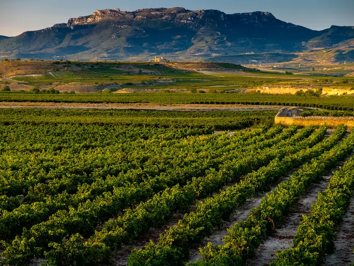
Image by FJ The GR-38 is a south-to-north crossing of Euskadi with a clear purpose: follow the old muleteer road that carried wine from Rioja Alavesa towards the Cantabrian coast and fish back inland. In 166 km it moves from the vineyards and warm stone towns of Oyón/Oion and Laguardia over the rocky Sierra de Cantabria/Toloño, through the Okina Gorge and Llanada Alavesa reservoirs, into Urkiola’s beech forests and the green hills of Bizkaia before finishing at the fishing harbour of Bermeo — a varied, culture-rich route for fit walkers who want more than a simple valley walk.
The route is not technical, but it asks for stamina: expect long inn-to-inn days, a steep high crossing near Puerto del Toro at around 1,200 m, and several stages where accommodation and transport choices need planning. This guide covers the stages, day-by-day logistics, accommodation, food and resupply, public transport, terrain, navigation and the common mistakes to avoid.
Stage-by-Stage Guide
Stage distances on the GR-38 vary slightly between official descriptions, guide sites and GPS tracks. The figures below use rounded planning distances for the seven-stage Oyón/Oion to Bermeo route; expect small differences on the ground, especially where the route has been updated or re-waymarked.
Stage 1: Oyón/Oion to Laguardia
Distance: about 17 km
Typical time: around 4 hr 30 min
Character: a rolling vineyard stage across Rioja Alavesa, with easy gradients but high sun exposure.
The GR-38 begins in the centre of Oyón/Oion, leaving from the Church of Santa María de la Asunción. This first day is not difficult in mountain terms, but it sets the pattern for the early part of the route: long open tracks, agricultural country, scattered villages and a need to carry what you need between settlements.
The route crosses the vineyard landscape of the Ebro plain, passing Assa and El Campillar before climbing gradually to the walled hilltop town of Laguardia. The walking is mostly on paved tracks, dirt roads and short asphalted sections. Underfoot conditions are usually straightforward in dry weather, and lightweight walking shoes may be enough, but there is little shade and the repeated small rises and dips make the day feel more tiring in heat than the distance suggests.
Key points on the stage include the village of Assa, near the remains of the Roman bridge of Mantible over the Ebro, and El Campillar roughly midway along the route. The approach to Laguardia is the highlight: the town sits above the vineyards and is one of the best overnight stops on the whole trail, with its medieval walls and underground wine cellars beneath the streets.
Food and water: carry food and plenty of water from Oyón/Oion. There are villages en route, but no reliable intermediate café or food stop should be assumed. In warm weather, this is a hot, exposed stage with very limited shade.
Accommodation and services: Laguardia has the strongest accommodation choice in the early section, including rural hotels, wine-tourism hotels and pensions such as Hotel Castillo El Collado, Hotel Silken Villa de Laguardia, Hospedería de los Parajes and Pensión Biazteri. It also has restaurants, pintxos bars and shops for resupply. Accommodation should be booked ahead during wine-tourism periods, especially around the late September and October harvest season.
Transport and access: Oyón/Oion is reached by Alavabus Line 8 from Logroño bus station, with Logroño the nearest mainline rail and coach hub. Laguardia is also on the same bus corridor. Current timetables should be checked before travelling.
Navigation and warnings: waymarking is generally good, but GR-99 and GR-120 markings overlap in places, so follow the red-and-white GR-38 flashes carefully. Older descriptions may not match the current approach to Laguardia, where the route has been updated near the lagoon complex. Take particular care at road crossings near Assa and El Campillar, where the route interacts with the national road.
Stage 2: Laguardia to Albaina
Distance: about 23 km
Typical time: around 7 hr 25 min
Character: the hardest mountain day of the GR-38, crossing the Sierra de Cantabria / Sierra de Toloño at the route’s high point.
This is the key test of the route. The stage climbs from the vineyards of Laguardia to the limestone ridge of the Sierra de Cantabria / Sierra de Toloño, crosses near the Puerto del Toro at about 1,200 m, then drops north through forest before continuing through Treviño country to Albaina.
The first half, from Laguardia to Lagrán, is the main ascent of the whole trail. The route leaves Laguardia on tracks through vineyards, climbs through holm oak and reaches the high ridge, where the landscape changes abruptly from Mediterranean vineyard country to exposed limestone and mountain woodland. Views back over the Ebro plain are among the best on the GR-38. The descent towards Lagrán follows the Camino de los Carboneros through beech forest.
Lagrán is the natural break point. It is home to the GR-38 interpretation centre La Traviesa, which explains the arriero muleteer trade that gave the Wine and Fish Route its identity. Walkers wanting to reduce the difficulty can split the day here, walking Laguardia–Lagrán and Lagrán–Albaina on separate days.
The second half continues from Lagrán towards Laño and Albaina. Expect forest paths, muddy sections after rain, and several junctions that need attention. Near Laño, the route passes the Las Gobas rock-cut hermitage caves, a group of early medieval cave hermitages carved into the limestone cliffs in the County of Treviño.
Food and water: services are limited to villages such as Lagrán, Laño and Albaina. Carry at least 2 litres of water, more in hot weather. Do not rely on finding food between villages.
Accommodation and services: Albaina is a very small village with limited accommodation, so a bed must be arranged in advance. Lagrán is the more practical splitting point, with the Albergue San Bartolomé, a camping area, a sports centre and other basic facilities noted locally. Availability should be checked before travelling.
Transport and access: Laguardia has bus access from the Logroño–Oyón/Oion–Laguardia corridor. Lagrán and Albaina are small inland settlements; public transport options are limited and should not be assumed. This should be checked before travelling.
Navigation and warnings: waymarking is generally adequate, but this stage has several confusing junctions and overlapping local signs. A current GPX track is strongly recommended. The ridge crossing is exposed to wind, rain and poor visibility, and the limestone and forest paths can be slippery. After wet weather, the shaded forest sections between Lagrán, Laño and Albaina can be muddy.
Stage 3: Albaina to the Sanctuary of Estíbaliz
Distance: about 23 km
Typical time: around 6 hr 45 min
Character: a varied stage through Treviño villages, the River Ayuda gorge and the Montes de Vitoria before reaching the hilltop sanctuary at Estíbaliz.
Stage 3 is less high than Stage 2 but still a proper day out, with a mix of open fields, forest tracks, narrow paths and the limestone gorge of the River Ayuda. It can be split at Okina, making two roughly half-day sections: Albaina–Okina and Okina–Estíbaliz.
From Albaina, the GR-38 passes Pariza and Sáseta before entering the Okina Gorge, one of the most dramatic natural sections of the trail. The gorge is cut by the River Ayuda and has dense riverside vegetation, limestone walls and narrower sections that become more awkward in wet conditions. Beyond Okina, the route climbs across the Montes de Vitoria, with beech and mixed woodland, before descending towards the Sanctuary of Our Lady of Estíbaliz.
The sanctuary stands on a rocky promontory above the Llanada Alavesa plain and marks a clear change in the route. After the enclosed gorge and forested hills, the next stage opens out onto the agricultural plain and reservoirs of Álava.
Food and water: carry supplies from Albaina. Water may be available from streams in normal conditions, but this should not replace carrying enough for the day, especially in summer. The Okina–Estíbaliz half has no dependable intermediate service stop.
Accommodation and services: Estíbaliz is essentially a sanctuary site rather than a full village. The sanctuary offers rooms for pilgrims and visitors, but this must be arranged in advance. There are not the same independent services that would be found in a town.
Transport and access: Sáseta and Okina provide road access points for shortening or splitting the stage, but public transport should not be relied on without checking. This should be checked before travelling.
Navigation and warnings: the route is waymarked, but ferns, vegetation and tangled junctions can obscure signs, particularly in the gorge and forest sections. A GPX track is useful. The River Ayuda gorge is the main hazard: if it has been raining, expect slippery ground, mud and more complicated passage where the route interacts with the river.
Stage 4: Sanctuary of Estíbaliz to Otxandio
Distance: about 35 km
Typical time: around 9 hr 20 min
Character: the longest day of the GR-38, crossing the Llanada Alavesa and the reservoir country towards Otxandio.
This is the stage most walkers should think hardest about before committing to a seven-day schedule. It is not technically difficult, but the distance is severe and services are spread out. Splitting the stage at Legutio/Legutiano is strongly recommended for many walkers, turning the route into a more manageable eight-day itinerary.
From the Sanctuary of Estíbaliz, the route drops to Oreitia and Arbulu, then continues across the broad agricultural plain of the Llanada Alavesa. The walking is on a mixture of old paths, wide dirt tracks, paved roads, short highway sections and old Basque-Navarrese railway alignments. The stage passes near the Ullibarri-Gamboa reservoir, then continues through villages and reservoir country towards Legutio/Legutiano, with Urrunaga and Albina reservoirs on the wider line of the route.
Legutio is the key planning point. At about 25 km from Estíbaliz, it is a proper village with services and is the best place to stop if avoiding the full 35 km day. From Legutio, the remaining section to Otxandio is much shorter, though still requires attention after a long day if walked in one push.
Food and water: this stage has long gaps and several stretches without water points. Carry more than usual, particularly in summer or if walking the whole Estíbaliz–Otxandio stage in one day. Villages provide the only realistic opportunities for services.
Accommodation and services: Otxandio has useful accommodation for walkers, including Koikili Aterpetxea in the historic centre, Kerizara rural guesthouse and Etxebarri Landetxea. The town has basic shops and eating options, including Korostondo Jatetxea nearby. Legutio is the practical mid-stage overnight if splitting.
Transport and access: road access exists at the villages across the plain, especially around Legutio. Public transport options for splitting or joining this stage should be checked before travelling.
Navigation and warnings: fatigue is the main risk on this stage, followed by navigation errors at the many crossroads. Signposting is weaker around Mendibil, where several tracks meet, so a current GPX track is strongly advised. The plain can feel exposed in heat, wind or bad weather, and the road sections require care.
Stage 5: Otxandio to Durango
Distance: about 20 km
Typical time: around 5 hr 15 min
Character: a mountain-and-forest stage through Urkiola Natural Park, followed by a long descent to Durango.
After the long haul to Otxandio, Stage 5 is shorter and more scenic, but it should not be dismissed as easy. The route climbs steadily from Otxandio through beech and pine forest into Urkiola Natural Park, then descends steeply and stonily towards Mañaria, Izurtza and Durango.
The main landmark is the Urkiola Sanctuary, roughly halfway through the stage, dedicated to Saints Anthony and Thomas. Nearby, the Three Crosses viewpoint gives broad views in clear weather. The route then drops from the park towards Mañaria; this descent is one of the more foot-wearying sections of the trail because it loses a lot of height over rougher ground.
After Mañaria and Izurtza, the final approach to Durango includes about 2.5 km on or alongside a road, with pavement or roadside protection in places but enough traffic to require concentration. The stage ends in Durango, reaching the old town around Ezkurdi square and the area of San Pedro de Tabira.
Food and water: Urkiola is the best mid-stage stopping point, with a restaurant/bar by the sanctuary and a shelter that is sometimes open. Do not rely on the shelter being available. Mañaria has basic services, and Durango has full town facilities.
Accommodation and services: Durango is one of the best resupply and recovery points on the GR-38, with hotels, rooms, restaurants, supermarkets, bars and a tourist office at Kurutziaga 38. There are also casas rurales and nekazalturismoa rural guesthouses in the wider Durangaldea area.
Transport and access: Durango has good public transport links, including rail services, and is a practical place to start, stop or section-hike the route. Urkiola and Mañaria also provide road access points, but onward connections should be checked before travelling.
Navigation and warnings: the GR-38 is well marked through much of the mountain section, but there are several junctions, so do not walk on autopilot. Fog and rain in Urkiola can reduce visibility and make the rocky descent less pleasant. Trekking poles are useful on the descent to Mañaria. Take particular care on the Mañaria–Durango road section, where traffic is the main hazard. Dogs may be encountered around farmhouses.
Stage 6: Durango to Gernika-Lumo
Distance: about 27–28 km
Typical time: around 7 hr 50 min
Character: a long rural Bizkaia stage across the foothills of Mount Oiz, with pastoral hills, forest tracks, hermitages and a gradual transition towards Urdaibai.
This is the second major endurance day of the GR-38. It is shorter than Stage 4 but hillier and more enclosed, crossing the green rural country of the Mount Oiz foothills on old muleteer paths, forest tracks, minor roads and farmland lanes.
Leaving Durango, the route passes Iurreta and climbs into the rural neighbourhoods around Garai and Goiuria. Historic and religious landmarks are scattered through this stage, including the Church of San Miguel, the Ermita de San Martín in the Amatza area, the Ermita de San Juan de Momoitio and its necropolis, and the Ermita de Santa Katalina with its wooden portico. The route continues through Mauma, Albiz and Mendata, with baserris, pasture, deciduous woodland and rounded hills giving a very different feel from the vineyards and limestone sierra of the first two days.
The high ground around Astakurutze on the slopes of Mount Oiz gives wide views in good conditions. The descent towards Gernika-Lumo follows the Berrekondo river valley through the Lamikiz neighbourhood, with the first signs of the Urdaibai Biosphere Reserve appearing as the route approaches town.
Food and water: start with enough food and water from Durango. The villages on this stage are rural and services are limited, so do not plan the day around regular cafés or shops. Gernika-Lumo has full services at the end.
Accommodation and services: Gernika-Lumo is a proper town with hotels and guest accommodation, including Hotel Gernika, Hotel Boliña, Hotel Neguetxea and Akelarre Ostatua. It has restaurants, supermarkets and shops. Many walkers allow time to visit the Oak of Gernika and the peace museum connected with the 1937 bombing.
Transport and access: Gernika-Lumo has a railway station, with Euskotren services to Bilbao, and bus services also run towards Bilbao. Durango also has strong transport links, making this a realistic section-hiking stage if logistics are arranged in advance.
Navigation and warnings: waymarking is standard GR red-and-white and the terrain is less complex than the Mendibil area of Stage 4, but the day is long and has many rural track junctions. Keep concentration late in the stage, when fatigue can lead to wrong turns. Some asphalt walking is unavoidable.
Stage 7: Gernika-Lumo to Bermeo
Distance: about 18–19 km
Typical time: around 5 hr 40 min
Character: the final stage across Urdaibai, with estuary views, wooded hilltops and a descent to the fishing port of Bermeo.
The last day is moderate in distance and difficulty, but it is not simply a flat walk to the sea. The route leaves Gernika-Lumo and crosses rural nuclei, farmsteads, woodland and hill paths within the Urdaibai Biosphere Reserve before descending to Bermeo on the Bay of Biscay.
The best views come from the Arribieta and Katillotxu hill areas, where the route looks over the Urdaibai estuary, the Mundaka sandbanks and Izaro island. Katillotxu also has prehistoric interest, with four megalithic mounds and the remains of the Pakatene dolmen. The route then continues through the rural neighbourhood of Demiku before dropping into Bermeo, a working fishing port and the official end of the headline GR-38.
Food and water: resupply in Gernika-Lumo before leaving. Services en route are limited through the Urdaibai villages and rural neighbourhoods. Bermeo has full services at the finish, including bars and seafood restaurants around the harbour.
Accommodation and services: Bermeo has several accommodation options, including Hotel Nafarrola, Hotel Bermeo, B&Bs and hostels. It is a practical final overnight if not travelling straight back to Bilbao.
Transport and access: Bermeo station is on the Euskotren E4 line to Bilbao, with a typical journey of around 1–1.5 hours. Bizkaibus also serves Bilbao. Check current timetables before relying on same-day onward travel, as late departures may be limited.
Navigation and warnings: this stage has been re-homologated and re-waymarked, so follow current GR-38 markings and use an up-to-date GPX track rather than relying on older printed descriptions. The hilltops above Urdaibai are exposed in wind and poor weather, though the terrain is generally less severe than the sierra and Urkiola stages.
Coastal variants: near the end of the route, marked GR-38.1, GR-38.2 and GR-38.3 variants branch towards Lekeitio and Ondarroa. These add roughly 40–50 km and are separate from the headline seven-stage GR-38, which finishes at Bermeo.
Recommended Itinerary
Distances on the GR-38 vary slightly between official mapping and GPS tracks. Treat the figures below as planning distances, not survey measurements, and check official mapping before booking accommodation or transport.
Standard 7-day itinerary
This is the normal Oyón/Oion to Bermeo schedule and the best default plan for fit walkers who are comfortable with several long days. The key bookings are Albaina, Estíbaliz and Otxandio; accommodation is not evenly spaced along the route.
| Day | From | To | Approx. distance | Why this stage makes sense | Services/accommodation notes |
|---|---|---|---|---|---|
| 1 | Oyón/Oion | Laguardia | 17 km | A gentle opening day through Rioja Alavesa vineyards and cereal fields, finishing in the walled hilltop town of Laguardia. The shorter distance allows time to reach the start from Logroño and still arrive with daylight. | Laguardia has the strongest early-route accommodation choice, with hotels, pensiones, restaurants, bars, shops and wine-tourism services. Book well ahead in spring, on long weekends and around the September–October harvest period. |
| 2 | Laguardia | Albaina | 23 km | The hardest mountain day: the route climbs steep, rocky ground over the Sierra de Cantabria / Sierra de Toloño near the Puerto del Toro at around 1,200 m, then descends through beech and oak country. It also gives access to Lagrán, the La Traviesa GR-38 interpretation centre, and the Las Gobas rock-cut hermitages near Laño. | Albaina is very small and services are minimal. Accommodation must be arranged in advance; Iñakiren Etxea is a rural house in the village, and Bar Alonso is the main local service point. Do not rely on breakfast or shops being available in the morning; carry food from Laguardia or Lagrán. If Albaina is full, alternatives in nearby Treviño villages or a taxi/bus plan towards Vitoria-Gasteiz may be needed. This should be checked before travelling. |
| 3 | Albaina | Sanctuary of Estíbaliz | 23 km | A strong transition stage from the Treviño country through the Okina Gorge of the River Ayuda and out onto the Llanada Alavesa plains, finishing at the Romanesque hilltop sanctuary. | Hostal Estíbaliz is the logical overnight stop at the sanctuary, but room numbers are limited and the surrounding settlement has only basic services. Pre-book and carry enough food and water for the day. |
| 4 | Sanctuary of Estíbaliz | Otxandio | 35 km | The planning crux of the standard itinerary: a long, mostly flat or rolling march across the Llanada Alavesa, passing the Ullibarri-Gamboa reservoir, Legutio/Legutiano, Urrunaga and Albina reservoirs before reaching Otxandio. It is less rocky than Stage 2 but can be more tiring because of the distance. | Start early. Legutio is the main mid-stage service point and the natural place to split the day if needed. Otxandio has small-town services, including Koikili Aterpetxea hostel and Kerizara Baserria rural house. Book ahead, as arriving tired after 35 km with no room reserved is poor risk management. |
| 5 | Otxandio | Durango | 20 km | A shorter but rewarding day through Urkiola Natural Park, with beech forest, limestone scenery, the Urkiola sanctuary and the descent towards Durango. After the previous long stage, the distance is well placed. | Durango is one of the best resupply stops on the route, with hotels, pensiones, restaurants, supermarkets, shops and Euskotren connections. Use it to reset food, cash and gear before the Bizkaia hill stages. |
| 6 | Durango | Gernika-Lumo | 28 km | A demanding hill day across green pastoral country and the Mount Oiz foothills, passing small settlements and hermitages before descending towards Gernika-Lumo. Near Ziortza/Cenarruza, GR-38.1, GR-38.2 and GR-38.3 variants split off towards the coast; stay on the main GR-38 for Gernika. | Gernika-Lumo has a full range of hiker services, including hotels, pensiones, a hostel, restaurants, grocery shops and Euskotren. Carry a GPX track or detailed mapping, as waymarking can be less obvious in places on this section. |
| 7 | Gernika-Lumo | Bermeo | 18 km | A manageable final stage through the Urdaibai Biosphere Reserve, with estuary, woodland and coastal scenery before the finish at the fishing port of Bermeo. | Bermeo has hotels, pensiones, apartments, restaurants and coastal tourist services. Euskotren E4 and Bizkaibus connect Bermeo with Bilbao; verify current timetables before relying on same-day onward travel. |
Slower 8-day itinerary: split the Estíbaliz to Otxandio stage
This is the most useful adjustment for walkers who do not want a 35–37 km day. It keeps the character of the route intact and makes the Llanada Alavesa section far less pressured. The weak point is accommodation around Legutio/Legutiano, which should be checked before travelling.
| Day | From | To | Approx. distance | Why this stage makes sense | Services/accommodation notes |
|---|---|---|---|---|---|
| 1 | Oyón/Oion | Laguardia | 17 km | Same gentle opening stage as the standard itinerary, with time to settle into the route. | Good accommodation and food options, but book ahead in wine-tourism periods. |
| 2 | Laguardia | Albaina | 23 km | Keeps the Sierra de Toloño crossing as a full day rather than rushing it. | Albaina remains the key booking constraint; reserve accommodation or arrange a clear alternative before starting the route. |
| 3 | Albaina | Sanctuary of Estíbaliz | 23 km | A balanced day through Okina Gorge and onto the Álava plains. | Limited accommodation at Estíbaliz; pre-book. |
| 4 | Sanctuary of Estíbaliz | Legutio/Legutiano | About 25 km | Splits the official long Stage 4 at the most logical settlement, after the plains and reservoir walking north of Estíbaliz. | Legutio has bars and some services, but accommodation availability varies. This should be checked before travelling. |
| 5 | Legutio/Legutiano | Otxandio | About 9 km | A short recovery day over the remaining section to Otxandio. Stronger walkers can consider continuing to Durango, but that turns the day into a much longer hill stage. | Otxandio has small-town services and accommodation such as Koikili Aterpetxea and Kerizara Baserria. |
| 6 | Otxandio | Durango | 20 km | Gives Urkiola Natural Park its own day, rather than adding it onto the Legutio approach. | Durango is the best resupply and service point before Gernika-Lumo. |
| 7 | Durango | Gernika-Lumo | 28 km | Still a substantial day across the Mount Oiz foothills, but reached with fresher legs than on a forced 7-day schedule. | Gernika-Lumo has extensive accommodation, food, shops and transport. |
| 8 | Gernika-Lumo | Bermeo | 18 km | A short final day through Urdaibai, giving time for onward travel from Bermeo. | Bermeo has accommodation and transport to Bilbao by Euskotren E4 and Bizkaibus; check current timetables. |
Faster 6-day itinerary: only for very fit walkers
A 6-day GR-38 is possible, but it is not the most elegant way to walk the route because the shorter stages are not always the easiest ones to combine. The least disruptive version removes the overnight in Laguardia by combining the first two official stages, but that creates a very hard first day over the route’s main sierra crossing. It suits fast, self-sufficient walkers with early starts, stable weather and confirmed accommodation at Albaina.
| Day | From | To | Approx. distance | Why this stage makes sense | Services/accommodation notes |
|---|---|---|---|---|---|
| 1 | Oyón/Oion | Albaina | About 40 km | Combines the opening vineyard approach with the full Sierra de Toloño crossing. This is a severe start and should only be considered by walkers already comfortable with long mountain days. | Laguardia and Lagrán provide services en route, but the overnight constraint is still Albaina. Accommodation and food must be arranged before starting. |
| 2 | Albaina | Sanctuary of Estíbaliz | 23 km | Keeps the Okina Gorge and Treviño-to-Estíbaliz transition as a normal stage after the long first day. | Limited services at Estíbaliz; pre-book accommodation and carry food. |
| 3 | Sanctuary of Estíbaliz | Otxandio | 35 km | Retains the standard long plains stage to Otxandio. This makes the first half of the 6-day itinerary especially demanding. | Legutio is the main mid-stage service point. Otxandio accommodation should be reserved. |
| 4 | Otxandio | Durango | 20 km | A shorter day through Urkiola Natural Park, useful for recovery after two very long days in the first three. | Durango has the best resupply, accommodation and transport options on the central route. |
| 5 | Durango | Gernika-Lumo | 28 km | A full hill day over pastoral Bizkaia and the Mount Oiz foothills. | Stay on the main GR-38 where the coastal variants split. Gernika-Lumo has full town services. |
| 6 | Gernika-Lumo | Bermeo | 18 km | A shorter final stage through Urdaibai to the coast. | Bermeo has accommodation and onward transport to Bilbao; verify current Euskotren and Bizkaibus timetables. |
For most walkers, the 7-day itinerary is the best balance. The 8-day version is the more comfortable choice if there is any doubt about the Estíbaliz to Otxandio day. A 5-day plan is not recommended unless using custom logistics, as it would require repeated very long days and careful checking of official mapping, accommodation and transport before booking.
Planning the Route
How many days to allow
The official GR-38 structure is seven main stages from Oyón/Oion to Bermeo, but the practical itinerary is often dictated less by distance than by accommodation. A straight seven-day walk is realistic for fit walkers who are comfortable with long days and who have booked every overnight stop in advance. For many independent hikers, an eight-day plan is more sensible because it splits the very long Estíbaliz–Otxandio stage at Legutio/Legutiano.
| Itinerary | Best for | Main trade-off |
|---|---|---|
| 5–6 days | Very fit walkers moving fast, possibly combining the shorter first or final stage with an adjacent day | Less margin for heat, navigation delays, bar closures or long road/track sections |
| 7 days | The standard GR-38 schedule, one main stage per day | Stage 4 remains a major 35 km day and accommodation at some official endpoints is awkward |
| 8 days | Most moderately fit walkers who want a more robust plan | Requires booking Legutio/Legutiano and adjusting the standard stage sequence |
| Section hike | Walkers using Logroño, Vitoria-Gasteiz, Bilbao, Durango or Gernika-Lumo for access | Requires careful transport planning because there is no continuous public transport corridor along the trail |
The route is not ideal for improvising day by day. Rural accommodation is sparse in several places, and there is no Camino-style albergue network with beds every few kilometres. Book the overnight stops before committing to travel dates.
The key stage-planning decisions
Several stages look straightforward on paper but need planning attention. The table below highlights the decisions that matter most when building an itinerary.
| Section | Planning issue | Practical advice |
|---|---|---|
| Oyón/Oion to Laguardia | Shorter opening stage, but Laguardia is a popular wine-tourism town | Book Laguardia early, especially May–October and during the vendimia period in September–October |
| Laguardia to Albaina | The Sierra de Cantabria / Sierra de Toloño crossing is steep, rocky and reaches the route high point near Puerto del Toro | Treat this as one of the hardest days, not just a moderate 23 km walk; start early and carry enough food and water |
| Albaina overnight | Albaina has no accommodation in the village | Do not assume the official stage endpoint is a viable overnight stop; adapt the stage to sleep in Lagrán, arrange a taxi to accommodation off-route, or redesign the previous/next day. This should be checked before travelling |
| Albaina / Treviño area to Estíbaliz | Rural supply is limited; Okina has limited accommodation such as Casa Rural Kañiko | Book before setting out; do not rely on finding rooms in small villages on arrival |
| Estíbaliz to Otxandio | The longest standard stage, around 35 km, with long stretches across the Llanada Alavesa | Strong walkers can complete it in one day, but many should split it at Legutio/Legutiano: Estíbaliz–Legutio, then Legutio–Otxandio |
| Otxandio to Durango | Shorter in distance, but crosses Urkiola Natural Park and includes mountain terrain | Keep a proper hillwalking day in mind rather than treating it as an easy transfer between towns |
| Durango to Gernika-Lumo | Long and tiring across the Mount Oiz foothills; waymarking in parts of Bizkaia has been patchy | Download a GPX track and map before leaving Durango; do not rely only on painted waymarks |
| Gernika-Lumo to Bermeo | Shorter final day through Urdaibai towards the coast | Still book Bermeo ahead in summer and on long weekends; check return transport times before finishing late |
Accommodation: plan around beds, not just kilometres
Accommodation is the single most important constraint on the GR-38. Larger towns such as Laguardia, Durango, Gernika-Lumo and Bermeo have the best supply, while smaller villages can have very limited options or none at all.
Key pressure points:
- Laguardia: good choice of hotels, casas rurales and pensiones, but demand is high during the Rioja Alavesa wine-tourism season. Book early from May to October, especially around harvest time.
- Albaina: no accommodation in the village. This is the main trap in a simple seven-stage plan.
- Okina and the Treviño area: limited rural accommodation; book ahead if using this area to reshape the middle stages.
- Legutio/Legutiano: the logical place to split the long Estíbaliz–Otxandio stage. Accommodation availability should be secured before choosing an eight-day itinerary.
- Otxandio: limited supply overall; Kerizara Baserria is one rural guesthouse option, but pre-booking is strongly advised.
- Durango: the best accommodation base in the northern half of the route, with a wider choice of hotels and pensiones.
- Gernika-Lumo and Bermeo: adequate supply, but summer, weekends and Urdaibai visitor demand can tighten availability.
The Parador de Argomaniz is around 6 km off-route near Vitoria-Gasteiz and may suit walkers wanting a higher-comfort overnight, but it requires taxi logistics and does not sit naturally on the waymarked line.
Luggage transfer is not normally available as a standalone DIY courier service on the GR-38. Package operators such as Basquelands Way or Slow Walking may include luggage support within guided or self-guided arrangements; current availability should be checked before booking.
Food, water and daily logistics
Do not plan this route as though every village will have an open bar, shop or fountain at the moment needed. The GR-38 crosses populated areas, but also has long rural and mountain sections where services are intermittent.
- Carry lunch or substantial snacks every day, especially on the Sierra de Toloño crossing, the Treviño/Okina sections, the long Llanada Alavesa stage and the Durango–Gernika day.
- Fill water whenever there is a reliable opportunity in a village. Natural water sources should not be treated as dependable, and Stage 4 has long stretches without water points.
- Start early on the long days. A 06:30–07:00 start is sensible in summer and on the Estíbaliz–Otxandio and Durango–Gernika stages.
- Expect closures on Sundays and public holidays. Rural bars and small shops may close or keep limited hours; carry extra food when a stage falls on these days.
- Road and asphalt sections are part of the route, particularly on the Bizkaia side. Footwear should be comfortable for both rocky paths and hard surfaces.
Navigation and waymarking
The GR-38 is a waymarked Gran Recorrido with standard white-and-red flashes and GR-38 signage, but a map or downloaded GPX is still important. This is especially true on the Durango–Gernika stage, where waymarking has been unreliable in places in the past and route-finding can cost time.
Before departure, download offline maps and GPX tracks from a reliable current source, and carry enough phone battery or a power bank for long stages. In open agricultural sections, stay on the waymarked path where it crosses private land.
Shortening, extending and section hiking
Section hiking is practical because the route crosses or approaches several useful transport hubs, even though there is no through railway or single bus line following the GR-38.
Useful access points include:
- Oyón/Oion: reached from Logroño by Alavabus Line 8; Logroño has mainline rail and long-distance coach connections.
- Laguardia: also served by Alavabus Line 8, useful for starting after the first stage or creating a shorter Rioja Alavesa section.
- Vitoria-Gasteiz: a strong base for the Álava half; Estíbaliz is around 10 km from the city, and Vitoria-Gasteiz has Renfe and coach links.
- Durango: the best entry or exit point for the northern half, with Euskotren E1 services to Bilbao and good road access.
- Gernika-Lumo: connected to Bilbao by Euskotren E4 and Bizkaibus services, and useful for walking the Urdaibai/Bermeo finish separately.
- Bermeo: connected to Bilbao by Euskotren E4 and Bizkaibus A3515.
The Álava half, from Oyón/Oion towards Otxandio or Durango, works well as a standalone walk using Logroño and Vitoria-Gasteiz access. The Bizkaia half, from Durango to Bermeo, is also straightforward to organise from Bilbao.
For an extension, the GR-38.1, GR-38.2 and GR-38.3 coastal variants continue towards Lekeitio and Ondarroa instead of finishing at Bermeo, adding roughly 40 km or more depending on the variant used. This is a meaningful extension rather than a minor detour, so accommodation and return transport need separate planning.
The route can be walked in reverse from Bermeo to Oyón/Oion, but the south-to-north direction is the usual and slightly simpler option for transport planning: start via Logroño and finish with regular onward transport from Bermeo towards Bilbao.
Transport checks before committing
The GR-38 is point-to-point and has no continuous public transport running beside it. Transport is easy at the ends and at a few major mid-route points, but not necessarily from every overnight village.
- Start: reach Oyón/Oion from Logroño bus station on Alavabus Line 8, which continues towards Laguardia. Logroño is the nearest mainline rail and coach hub.
- Mid-route alternatives: Vitoria-Gasteiz is useful for the Estíbaliz area; Durango and Gernika-Lumo are useful for the Bizkaia stages.
- Finish: Bermeo has Euskotren E4 services towards Bilbao and Bizkaibus links, including Line A3515 through the Gernika-Bermeo corridor.
Timetables should be checked before travelling, particularly at weekends and on public holidays. Late-evening services can be limited, so avoid planning a long final walking day that depends on the last train or bus.
Weather, season and permits
Spring and autumn are the most comfortable planning windows. April to June usually offers milder temperatures and greener landscapes, though snow can still affect the Sierra de Toloño crossing in April. September and October bring harvest activity in Rioja Alavesa and autumn colour in Urkiola, but also higher accommodation pressure around Laguardia and wetter conditions towards the Basque coast.
July and August are workable, but the southern stages around Oyón/Oion and Laguardia can be very hot. Early starts and extra water capacity are important. Winter is not recommended for most walkers: the Sierra de Cantabria / Toloño crossing can carry snow or ice, daylight is short, and rural accommodation may reduce opening.
No permit is required to walk the GR-38. The route passes through Urkiola Natural Park and the Urdaibai Biosphere Reserve; normal protected-area rules apply, including no fires, taking litter out, and staying on marked paths where required.
Towns, Villages and Overnight Stops
Accommodation on the GR-38 is unevenly distributed. Laguardia, Durango, Gernika-Lumo and Bermeo are the easiest places to book; Albaina, Estíbaliz and Otxandio need more care. Several stage ends are small villages or religious sites rather than full-service trail towns, so beds should be arranged before committing to the standard seven-day schedule.
| Route point | Standard role | Practical accommodation note |
|---|---|---|
| Oyón/Oion | Start | Basic services only; many walkers sleep in Logroño or Laguardia before starting |
| Laguardia | End Day 1 | Best southern hub; book early in wine season and at weekends |
| Albaina | End Day 2 | Very limited; confirm a bed before walking there |
| Sanctuary of Estíbaliz | End Day 3 | Religious site, not a town; taxiing to Vitoria-Gasteiz is common if no local bed is available |
| Otxandio | End Day 4 | Limited but walker-friendly accommodation; book ahead |
| Durango | End Day 5 | Largest service town on the route between Vitoria-Gasteiz and Bilbao |
| Gernika-Lumo | End Day 6 | Good accommodation and transport; albergue beds can fill in peak season |
| Bermeo | Finish | Good end-point accommodation and onward transport to Bilbao |
Oyón/Oion
Oyón/Oion is the southern start of the GR-38 in Rioja Alavesa. The trail leaves from the Church of Santa María de la Asunción in the town centre. It is a small wine-producing Alavesa town, with the main practical services in the Oyón/Oion part of the municipality rather than in Barriobusto or Labraza.
For walkers, Oyón/Oion works as a functional start rather than a major overnight base. There are bars, cafés, small local shops and modest accommodation, including pensiones or casas rurales, but no dedicated hiker albergue. Many walkers arrive the day before and either stay locally, sleep in nearby Logroño, or start from accommodation in Laguardia if the first day’s logistics work better.
Transport is straightforward for the start: Alavabus Line 8 links Logroño bus station, Oyón/Oion and Laguardia, with Logroño about 10 minutes away by bus and serving as the nearest mainline rail and coach hub. Timetables should be checked before travelling, especially for early starts.
Laguardia
Laguardia is the obvious first-night stop and the strongest accommodation hub in the southern half of the route. It sits at the end of the first stage from Oyón/Oion, after roughly 17 km through Rioja Alavesa wine country, and is the last substantial town before the harder crossing of the Sierra de Cantabria / Sierra de Toloño.
Accommodation is much better developed here than in the smaller villages ahead. Options include hotels, boutique stays, guesthouses, B&Bs and rural properties, with prices commonly starting from around €65 per night. Hotel Silken Villa de Laguardia, Hospedería de los Parajes, and rural guesthouses such as Larretxori and Biazteri are examples of the range available. Demand is high during the wine harvest period in late September and October, and weekends can also book out, so this is one of the most important places to reserve early.
Food is one of Laguardia’s strengths. There are restaurants, pintxos bars, wine bars, winery restaurants, delis and general provisions. It is a good place to eat properly, buy lunch supplies for Stage 2 and make sure bottles are full before the mountain day to Albaina.
Alavabus Line 8 connects Laguardia with Oyón/Oion and Logroño. The tourist office is at Calle Mayor, 52, Casa Garcetas. The town itself is compact but busy, with cobbled streets, walls and many underground wine cellars beneath the houses; this is worth allowing time for, but the main hiking point is simple: Laguardia is the last easy resupply and accommodation stop before the route becomes more rural.
Lagrán
Lagrán lies part-way through Stage 2, in the foothills of the Sierra de Toloño, after the route has left the vineyards and climbed into more mountainous country. It is not the standard end of the day on the seven-stage itinerary, but it can be useful for walkers wanting to split the hard Laguardia–Albaina stage or build a slower itinerary.
The key hiker facility is the Albergue de San Bartolomé, a municipal hostel arranged through lagran.eus. There is also a free camping area, motorhome parking and rural agrotourism accommodation such as Rumin Enea and Arriaga Etxea. Capacity is limited, so beds should be booked rather than assumed.
Food and shopping are village-scale. The La Traviesa Interpretation Centre is important on this route because it explains the muleteer trade history behind the GR-38. The adjacent La Traviesa restaurant can be useful for lunch or an overnight stop, but opening periods can change, so check ahead. Carrying provisions from Laguardia remains sensible.
Lagrán has a daily bus connection towards Vitoria-Gasteiz on the Lagrán–Vitoria/Gasteiz route, but services are not frequent enough to rely on casually. Treat it as a small mountain village with some helpful facilities, not as a full-service trail town.
Albaina
Albaina is the standard end of Stage 2, reached after the route crosses the Sierra de Cantabria / Sierra de Toloño from Laguardia. It is a tiny hamlet in the Condado de Treviño, the Castilian enclave within Álava, and it has the service level of a small rural settlement rather than a hiking resort.
Accommodation is the main planning issue. Beds in Albaina itself are very limited and may be basic or absent for the date required. Some walkers use pre-arranged rural accommodation elsewhere in the Treviño area, push on to a nearby village, or arrange a taxi transfer to Vitoria-Gasteiz, around 30 km away. Do not arrive in Albaina expecting to find a room on spec; confirm accommodation before walking Stage 2.
Food and shops are also limited. Water sources and fuentes may be encountered on the approach, but dinner, breakfast and next-day supplies should be planned in advance. The surrounding area includes Laño and the Las Gobas rock-cut hermitages, but those are points of interest rather than service stops.
Albaina has road access via the CL-127 and a bus stop on the Vitoria/Gasteiz–Lagrán service, but public transport is limited. It is best treated as a rural stage end where the bed booking determines the whole day’s viability.
Sanctuary of Estíbaliz
The Sanctuary of Estíbaliz is the standard end of Stage 3 from Albaina. It is a Romanesque hilltop sanctuary about 10 km east of Vitoria-Gasteiz and a symbolic marker as the GR-38 enters the Llanada Alavesa plains. It is not a village, so logistics are more awkward than the name “stage end” suggests.
Accommodation at the sanctuary itself is limited. Some walkers use nearby Argandoña or Ullibarri-Arrazua for rural accommodation, while others take a taxi or bus connection into Vitoria-Gasteiz for the night and return to Estíbaliz the next morning. Vitoria-Gasteiz has extensive hotel options, making it the practical fallback when local rural beds are not available.
There is a café/bar at the sanctuary complex and basic provisions, but it should not be treated as a full resupply point. Carry enough food to reach the end of the stage and plan dinner before arrival.
There is no direct public transport to the sanctuary. The nearest practical access is by road, including the A-3014, with taxi transfer from Vitoria-Gasteiz taking around 20 minutes. This is one of the route’s key accommodation pinch points, and it is worth solving before booking the rest of the itinerary.
Legutio/Legutiano
Legutio/Legutiano is a useful mid-stage stop on the long Stage 4 from Estíbaliz to Otxandio. It sits on the Álava plain near the Urrunaga reservoir and is the main practical break on a day of roughly 35 km.
It is not normally used as an overnight stop on the standard itinerary, but it matters because Stage 4 is long and has relatively few services. Bars in Legutio are useful for coffee, pintxos and a proper pause, and there are some shops for provisions. Use it to reset food and water before continuing towards Otxandio.
Public transport and road access exist, but this section should be planned as a walking day rather than a hop-on, hop-off stage. If cutting Stage 4 short, accommodation and onward transport would need to be arranged in advance.
Otxandio
Otxandio is the standard end of Stage 4 and the start of Stage 5 into Urkiola Natural Park. It is a small historic town in Bizkaia, at the foot of the Urkiola massif, and it arrives at exactly the right point after the long walk from Estíbaliz.
Accommodation is limited but well suited to walkers. Koikili Aterpetxea is a purpose-renovated hostel in the historic centre, with shared and private rooms, kitchen facilities, a lift and services aimed at active travellers. Kerizara farmhouse rural B&B and other Nekatur-listed rural houses add further options around the town and nearby countryside. Capacity is not large, so book ahead, particularly in spring and summer.
Otxandio has bars for breakfast, pintxos and rations, plus some shops for provisions. It is an important place to eat well, recover and prepare for the next day’s crossing through Urkiola Natural Park to Durango.
There is no major rail service. Road access is via the BI-625 towards Durango, about 20 km away, and Vitoria-Gasteiz, around 45 km away. Taxi transfer is a realistic option for emergencies, missed accommodation or resupply problems, but should be arranged rather than assumed late in the day.
Durango
Durango is the best all-round service town on the GR-38 between the Vitoria-Gasteiz area and the coast. It is the standard end of Stage 5 from Otxandio, after the route crosses Urkiola Natural Park and descends through forest and villages such as Mañaria and Izurtza.
Accommodation is varied and much easier to arrange than in Albaina, Estíbaliz or Otxandio. Options include hotels in or near the historic centre, B&Bs such as Eguzki B&B, and rural houses towards Urkiola Natural Park. Typical prices fall roughly in the €50–€120 per night range, depending on season and room type.
Food and resupply are strong. Durango has supermarkets, cafés, restaurants and a good pintxos bar scene. It is the best place on the route to replace trail food, deal with pharmacy needs, use laundry services if available at accommodation, or take a rest day. Sunday trading can be more limited, so plan resupply timing accordingly.
Transport is also excellent by GR-38 standards. Euskotren E1 connects Durango with Bilbao and Donostia-San Sebastián, with Bilbao about 40 minutes away by train. Road coaches also serve the town. The tourist office is in the Kurutzesantu Museum. For independent hikers, Durango is the easiest place to pause, bail out, restart or reconfigure the itinerary.
Stage 6 from Durango to Gernika-Lumo crosses more rural hill country around the Mount Oiz foothills. Downloading the GPX is strongly advised, as waymarking on this section can be weaker in places than on the more straightforward town-to-town stages.
Gernika-Lumo
Gernika-Lumo is the standard end of Stage 6 and the final overnight stop before Bermeo. It sits at the head of the Urdaibai Biosphere Reserve estuary and is a historic town with good services, making it a natural place to stop after the long day from Durango.
Accommodation is well developed. Albergue Gernika has around 70 beds in rooms of 4–12 and is popular with walkers. Hotel Gernika, Hotel Neguetxea, holiday apartments and private rentals provide additional options, with prices commonly starting from around €68 per night. The albergue can fill in peak walking periods, so book early if relying on a budget bed.
Food is easy here. There are pintxos bars, restaurants, supermarkets and, on Mondays, a major market with local produce. It is a good place to buy supplies for the final stage to Bermeo, although that stage is shorter than the previous day.
Transport links are useful for both access and contingency planning. Euskotren E4 connects Gernika-Lumo with Bilbao, and Bizkaibus coaches also serve the town. The train journey to Bilbao is about one hour. Gernika-Lumo also deserves time for the Casa de Juntas and Gernikako Arbola, but from a hiking perspective its main value is as a reliable, well-served final base before the coast.
Bermeo
Bermeo is the northern finish of the main GR-38, a working fishing port on the Bay of Biscay within the Urdaibai Biosphere Reserve. It is the logical place to finish, eat properly and stay overnight before travelling on.
Accommodation is available in the town and surrounding hills. Options include Hostal Aldatzeta Ostatua in the centre, Andra Mari Apartamentu Turistikoak in the historic centre, Hotel Nafarrola above town, plus holiday apartments and private rentals. Prices commonly start from around €70 per night, with seasonal variation.
Food is a major advantage of finishing here. The harbour area has pintxos bars and seafood restaurants, with local dishes built around fresh fish and bacalao. Most walkers will prefer to stay the night rather than rush straight onto transport after the final stage from Gernika-Lumo.
Onward transport is straightforward. Euskotren E4 runs from Bermeo to Bilbao, serving Atxuri/Casco Viejo, with a journey of about 1 hour 20 minutes and fares around €3.40. Bizkaibus also links Bermeo with Bilbao, and taxis are a practical backup if the train timetable does not fit. Current timetables and fares should be checked before travelling.
San Juan de Gaztelugatxe can be visited as a post-walk detour from the Bermeo area, by walking or by bus towards Bakio, but it is not part of the main GR-38 finish.
Smaller villages and service-light points
Several named places on the GR-38 are important for navigation, history or scenery but should not be treated as reliable overnight stops.
- Assa: early on Stage 1, near the Puente de Mantible Roman bridge. No useful walker services.
- El Campillar and La Hoya: close to the Laguardia approach. La Hoya is an Iron Age archaeological site rather than a service village.
- Laño: in the Condado de Treviño, known for the Las Gobas rock-cut hermitages. No reliable walker services.
- Pariza, Sáseta and Okina: rural points around the Okina Gorge and River Ayuda. Casa Rural Kañiko in Okina can be useful for walkers adapting Stages 2 or 3, but availability and meals should be checked before relying on it.
- Oreitia, Arbulu and Amarita: small villages across the Llanada Alavesa section. Useful as route markers, not as major resupply bases.
- Ullibarri-Gamboa, Urrunaga and Albina reservoirs: important landscape features on the long plains stage towards Otxandio; carry food and water rather than assuming services at the water’s edge.
- Urkiola Sanctuary: an atmospheric stop in Urkiola Natural Park at around 1,050 m, but not an overnight base. Continue to Durango unless separate accommodation has been arranged.
- Mañaria and Izurtza: small villages on the descent from Urkiola to Durango. They can provide basic services but Durango is the practical overnight hub.
- Iurreta, Garai/Goiuria, Mauma, Albiz and Mendata: rural settlements and waypoints between Durango and Gernika-Lumo. Do not plan this stage around casual resupply; leave Durango prepared.
Getting to the Start
The GR-38 starts in the centre of Oyón/Oion at the Church of Santa María de la Asunción. Oyón/Oion is a small Rioja Alavesa wine village close to the La Rioja border, with no mainline railway. For most walkers, the practical gateway is Logroño, around 6.4 km to the south and about 10 minutes away by local bus or taxi.
By train
The nearest mainline railway station is Logroño, served by Renfe. Logroño station is in the same transport complex as the city’s bus station, which makes the onward connection to Oyón/Oion straightforward.
Typical rail approaches are:
| Starting city | Route to Logroño | Typical journey time | Notes |
|---|---|---|---|
| Madrid Atocha | Renfe Alvia; OUIGO also operates on this corridor | Fastest around 3 hr 45 min; often nearer 4 hr 45 min | Advance fares can be much cheaper; from about €16 booked ahead |
| Barcelona Sants | Renfe Alvia | About 3 hr 54 min–4 hr 04 min | Usually several trains per day; advance fares from about €23 |
| Bilbao Abando | Renfe Alvia | About 2 hr 30 min | Typically limited service; advance fares from about €7 |
Timetables, train frequency and fares vary by date and booking window. This should be checked before travelling, especially if relying on the Bilbao–Logroño train to connect with the afternoon bus to Oyón/Oion.
Once at Logroño station, continue by Alavabus Line 8 or taxi.
By bus
The standard public-transport approach to the start is Alavabus Line 8, operated by the Álava Provincial Council.
Alavabus Line 8: Logroño bus station → Oyón/Oion → Laguardia
Journey time: about 10 minutes from Logroño to Oyón/Oion
Typical fare: about €1–3 one way
Operator contact: alavabus.eus · +34 945 18 20 60 · [email protected]
The Line 8 bus leaves from Logroño bus station, beside the railway station, and continues beyond Oyón/Oion to Laguardia, the end of Stage 1. Weekday departures may start from around 06:45, with services roughly every two hours and a last service around mid-afternoon. The timetable changes between seasons, so this should be checked before travelling.
A second option is Alavabus Line 9, which connects Vitoria-Gasteiz with Logroño via a mountain route and stops at Oyón/Oion. This is useful if arriving through Vitoria-Gasteiz, but frequency is limited and weekend service may be reduced. It runs on separate winter and summer schedules, so this should be checked carefully before building a travel day around it.
If the bus times do not work, a taxi from Logroño is short and practical. The trip from Logroño station to Oyón/Oion is about 6.4 km and usually takes around 9–10 minutes. A typical fare is about €12–17. Logroño taxi operators include Unitaxi Rioja Logroño (+34 941 50 50 50), LogroTaxi (+34 630 92 66 11) and Logroño Taxi (+34 623 44 52 76). A taxi is often the simplest option for an early start, a late arrival, or if travelling with bulky luggage.
By car
Oyón/Oion is easy to reach by road from Logroño: cross the Ebro and take the A-124 / LR-115 towards Oyón/Oion. The drive is about 6 km and usually takes around 10 minutes. From Vitoria-Gasteiz, the approach is roughly 60 km and around 50 minutes; from Bilbao, allow roughly 130 km and about 1 hr 20 min via the A-68 towards Logroño.
Driving to the start is less convenient than public transport because the GR-38 is a point-to-point trail ending in Bermeo. Leaving a car in Oyón/Oion for a week or more is possible in practical terms, but not ideal unless there is a clear plan for collecting it.
Common car-based options are:
| Option | Practicality |
|---|---|
| Get dropped at Oyón/Oion | Best if a travelling companion can continue by car and meet you at Bermeo |
| Park in Logroño and bus/taxi to Oyón/Oion | More sensible than leaving a car in a small village; Logroño has paid car parks near the station area |
| One-way car hire | Possible from larger hubs such as Bilbao or Logroño, but one-way drop-off fees can make it expensive |
| Leave the car in Oyón/Oion | On-street parking is available, including areas near the swimming pool and Etorbidea Diputación, but long-stay suitability should be checked locally before relying on it |
For most walkers, parking in Logroño and using the short bus or taxi transfer to Oyón/Oion is the cleaner solution.
From the nearest airport
Bilbao Airport (BIO / Loiu) is the most useful airport for most international walkers. It has a much wider choice of flights than the smaller regional airports and connects reasonably well with Logroño.
| Airport | Usefulness for the GR-38 start | Typical onward route |
|---|---|---|
| Bilbao Airport (BIO) | Best all-round option for international arrivals | Airport bus to Bilbao Intermodal, then bus or train to Logroño, then Alavabus/taxi to Oyón/Oion |
| Madrid Barajas (MAD) | Strong option for long-haul arrivals | Train from Madrid Atocha to Logroño, then Alavabus/taxi to Oyón/Oion |
| Barcelona El Prat (BCN) | Viable if flight times or fares suit | Train from Barcelona Sants to Logroño, then Alavabus/taxi to Oyón/Oion |
| Logroño–Agoncillo (RJL) | Very limited use | Small domestic airport about 10 km west of Logroño; not a practical gateway for most walkers |
| Pamplona (PNA) | Usually less convenient | Limited connections and about 80 km from Logroño |
From Bilbao Airport, take the Bizkaibus A3247 into Bilbao Intermodal, then continue to Logroño by bus or train. There is no direct bus from Bilbao Airport to Logroño. Bilbao to Logroño by train is typically around 2 hr 30 min but has limited departures; the bus is usually around 2 hr 45 min and may offer more practical timings. From Logroño, continue to Oyón/Oion by Alavabus Line 8 or taxi. A realistic airport-to-Oyón/Oion journey via Bilbao and Logroño is around 3–3.5 hours with a smooth connection.
Airport transfers, bus departures and rail times change seasonally and by day of week. This should be checked before travelling, particularly if arriving late in the day.
Where to stay before starting
Logroño is the best pre-trail base for most walkers. It has plentiful accommodation, food shops, restaurants and transport links, and it is only about 10 minutes from Oyón/Oion by bus or taxi. It is also a Camino de Santiago town, so budget accommodation is easier to find than in the smaller villages on the GR-38.
Typical Logroño accommodation ranges are:
| Type | Typical price |
|---|---|
| Albergues | about €12–15 per night |
| Hostels and pensiones | about €40–60 |
| Mid-range hotels | about €54–80 |
Oyón/Oion is the most convenient place to sleep if accommodation is available, as the trail starts directly from the town centre. Choice is limited, with small guesthouse or casa rural-style options rather than a broad hotel market, so book ahead.
Laguardia is another option, especially for walkers who want to spend a night in the Rioja Alavesa wine town before beginning. It lies beyond Oyón/Oion on Alavabus Line 8 and is the end of Stage 1. Staying there before the walk means either returning to Oyón/Oion to start the GR-38 properly, or deliberately skipping the first 17 km stage from Oyón/Oion to Laguardia.
Getting Home from the Finish
The GR-38 main route finishes in Bermeo, a working fishing port on the Bay of Biscay. Bermeo has useful onward public transport, but it is not a major interchange: most walkers leave via Bilbao, using either Euskotren E4 or Bizkaibus A3527. Check current timetables before relying on an evening connection, especially at weekends or outside the main season.
By train
Bermeo is on the Euskotren E4 line towards Bilbao. This is the most straightforward rail option from the finish, but it is not a fast mainline service.
| Route | Operator | Typical journey | Notes |
|---|---|---|---|
| Bermeo → Amorebieta Geltokia → Bilbao Matiko | Euskotren E4 | Around 83 minutes | Requires a change at Amorebieta Geltokia; allow for a waiting time of around 50 minutes |
The line runs through the Urdaibai area via places such as Mundaka, Busturia, Gernika-Lumo and Muxika before joining the Bilbao suburban network. Bilbao Matiko is useful for the city centre and onward metro connections; Atxuri/Casco Viejo is the historic Euskotren area close to Bilbao’s Old Quarter.
Weekday services from Bermeo start from around 06:10, with the last service around 21:10. Weekend and holiday times may differ. Tickets are bought from station machines and card payment is normally accepted. A zone 1–4 single fare is roughly €3.40; using a CREDITRANS reloadable card can reduce the fare to about €1.60. Fares and times should be checked before travelling.
For onward long-distance travel, continue across Bilbao to Abando station, the RENFE mainline hub. Direct Alvia services link Bilbao with Madrid in about 4.5 hours and Barcelona in about 6 hours 50 minutes. Donostia/San Sebastián can also be reached from Bilbao, including by Euskotren E1, taking around 2.5 hours.
By bus
The fastest public-transport option for many walkers is the direct Bizkaibus A3527 express bus from Bermeo to Bilbao.
| Route | Operator | Typical journey | Main Bilbao stop |
|---|---|---|---|
| Bermeo → Mungia → Bilbao | Bizkaibus A3527 | Around 50 minutes | Moyua Plaza / city centre |
The A3527 runs via the autopista and avoids the train change at Amorebieta, so it is usually the better choice if the aim is simply to reach central Bilbao quickly. Services are broadly hourly, with first departures from Bermeo around 06:22 and last departures around 20:52, arriving in Bilbao at about 21:35. These times are timetable-dependent and should be checked with Bizkaibus before travelling.
A single fare is typically around €2–4. Moyua Plaza is central, close to Gran Vía, metro connections and onward city buses.
By car/taxi
A taxi or private transfer from Bermeo to Bilbao centre usually takes around 45–55 minutes by road, depending on traffic and route. Bermeo to Bilbao is roughly 35–40 km by road. A normal local taxi fare to Bilbao is likely to be in the region of €60–80, but the fare should be agreed or checked locally before setting off.
Bermeo is a small town, so do not assume a taxi will be waiting at the harbour, particularly outside busy periods or late in the day. Pre-booking is the safer option if connecting with a train, coach or flight.
For Bilbao Airport, a direct car transfer from Bermeo normally takes around 30–35 minutes. The airport is about 28–32 km from Bermeo, and a private transfer is likely to cost roughly €50–70. Confirm current rates before booking.
From the nearest airport
The nearest major airport is Bilbao Airport (BIO), at Loiu. There is no direct public bus from Bermeo to the airport, so public-transport journeys normally go via central Bilbao.
The usual route is:
- Bermeo → Bilbao by Bizkaibus A3527 or Euskotren E4.
- Bilbao city centre → Bilbao Airport by Bizkaibus A3247 or taxi.
The A3247 airport bus runs from Bilbao Intermodal / San Mamés via Gran Vía and Moyua to the airport. It runs every 20 minutes in winter and every 15 minutes in summer, with a journey time of about 20 minutes from Moyua. The fare is about €3 and services generally operate from 06:00 to 00:00.
Allow around 1 hour 45 minutes to 2 hours 30 minutes from Bermeo to Bilbao Airport by public transport, depending on the connection in Bilbao. For international flights, allow at least 2.5 hours from leaving Bermeo to the airport check-in stage, and more if using an evening bus or train.
A taxi from central Bilbao to the airport takes about 15 minutes and costs roughly €25–35.
Where to stay at the finish
Staying overnight in Bermeo is often the most relaxed option. The final stage from Gernika-Lumo to Bermeo is around 18 km, so many walkers arrive in the afternoon with enough time to finish properly at the port rather than rushing straight onto a connection.
Bermeo has a small but useful accommodation base, including hotels, pensiones and rural stays. Options include Hotel Bermeo near the harbour area, Eco Hotel Rural Lurdeia in rural surroundings, and Hotel Nafarrola, a restored caserío-style farmhouse. Typical room prices are roughly €52–120 per night depending on season and accommodation type; book ahead in busy periods.
If finishing late in the day, staying in Bermeo avoids relying on the last train or bus to Bilbao. If continuing the GR-38.1/38.2/38.3 coastal variants towards Lekeitio and Ondarroa, Bermeo also works as a practical overnight base before moving on.
Which Direction Should You Walk?
The GR-38 is best walked south to north, from Oyón/Oion to Bermeo. This is the standard direction used by the official stage structure, route descriptions, profiles and GPX tracks, and it matches the modern identity of the trail: leaving the Rioja Alavesa wine country and walking towards the fishing ports of the Bay of Biscay.
The historic muleteer trade moved in both directions — fish inland, wine and other goods back towards the coast — but the signed walking route is normally followed from wine country to sea.
Standard direction: Oyón/Oion to Bermeo
Walking south to north gives the route its strongest sense of progression. The first day starts in the vineyards and dry, open landscapes around Oyón/Oion and Laguardia. Stage 2 then tackles the major mountain crossing of the Sierra de Cantabria / Sierra de Toloño, reaching the route’s high point near the Puerto del Toro at around 1,200 m.
This direction also puts the hardest side of the Sierra de Toloño underfoot as an ascent rather than a descent. From the Laguardia side, the climb is steep, rocky and exposed in places, with a demanding rise over a relatively short distance. Once over the top, the northern side gives a more wooded descent through beech and oak country towards Albaina. For most walkers, climbing the rougher southern face is preferable to descending it on tired legs.
After that, the landscape becomes progressively greener and more Atlantic: the Okina Gorge and River Ayuda, the Llanada Alavesa plains and reservoirs, Urkiola Natural Park, the pastoral hills around Mount Oiz, then the Urdaibai Biosphere Reserve and the final approach to Bermeo. Reaching the working fishing port after a week of walking gives the route a clear and satisfying finish.
Reverse direction: Bermeo to Oyón/Oion
The reverse is possible, but it is less natural for this route. It means starting at the coast and finishing inland in Rioja Alavesa, which removes much of the trail’s wine-to-sea narrative. The Sierra de Toloño crossing also changes character: the gentler, wooded northern side becomes the ascent, while the steeper rocky southern face becomes the descent towards Laguardia. That can be harder on knees and requires care in poor weather or when the limestone is loose underfoot.
Waymarking is another consideration. The GR-38 is presented and signed for the standard south-to-north itinerary. In reverse, walkers need to be more attentive at junctions and should not rely on the visual flow of the white-and-red GR flashes in quite the same way. A GPX track or detailed mapping is particularly useful if walking north to south.
Transport logistics by direction
For most walkers, transport also favours the standard direction.
| Direction | Start logistics | Finish logistics | Practical verdict |
|---|---|---|---|
| Oyón/Oion → Bermeo | Reach Oyón/Oion via Logroño, using Alavabus Line 8 from Logroño bus station towards Oyón/Oion and Laguardia. Logroño is the nearest mainline rail hub. | From Bermeo, Euskotren E4 and Bizkaibus link to Bilbao, with onward rail, coach and airport connections. | Usually the easiest flow: make the slightly fiddlier connection at the start, then finish with straightforward access to Bilbao. |
| Bermeo → Oyón/Oion | Bermeo is easy to reach from Bilbao by Euskotren E4 or Bizkaibus. | Leaving Oyón/Oion normally requires the bus connection back to Logroño. | Practical, but less convenient at the end of a long walk, especially if onward travel is time-sensitive. |
Current bus and train timetables should be checked before travelling, especially for early starts, Sundays and public holidays.
Accommodation flow
Direction does not greatly change the accommodation constraints. The stage towns remain the same, and the limiting points remain the smaller places rather than the direction of travel. Laguardia, Durango, Gernika-Lumo and Bermeo offer more choice, while places such as Albaina require more advance planning. The Estíbaliz stop also needs to be arranged carefully because the stage structure is not as flexible as on routes with frequent accommodation every few kilometres.
Walking south to north has one practical advantage: the first night is usually in Laguardia, a well-established wine-tourism town with a stronger accommodation base, while the final night can be in Bermeo or linked onward to Bilbao. In reverse, the same pinch points exist, but the walk ends at the less-connected southern end.
Weather and wind
Weather is not a strong reason to reverse the GR-38. The Basque Country is influenced by Atlantic weather, and winds are often from the north or north-west, so south-to-north walkers may meet headwinds on some northern sections. In practice, the route passes through woodland, valleys, hills and built-up areas, so wind direction is usually less important than heat, rain and visibility.
The southern Rioja Alavesa stages can be hot and sunny in summer, particularly around the Laguardia side of the Sierra de Toloño. The northern stages are generally greener and wetter. Neither direction avoids these conditions; season, daily start time and weather forecast matter more.
Recommendation
Walk the GR-38 south to north: Oyón/Oion to Bermeo.
This is the official and most common direction, the waymarking and stage information are built around it, the transport flow is generally easier, and the scenery develops in the most coherent order — vineyards, sierra, plains, reservoirs, Urkiola, Urdaibai and finally the sea. Reverse the route only for a specific logistical reason, such as accommodation availability or connecting from another itinerary.
Accommodation Along the Route
Accommodation is the main logistical constraint on the GR-38. The route can work well as an inn-to-inn walk, but not as a simple “turn up at the end of each stage” itinerary. Beds are concentrated in Laguardia, Durango, Gernika-Lumo and Bermeo, while Albaina and the Sanctuary of Estíbaliz create real planning gaps.
There is no Camino-style pilgrim hostel network on this route. Expect to use commercial accommodation: hotels, pensiones, casas rurales and agroturismos. Book ahead throughout, and book Laguardia, Lagrán and Otxandio before committing to transport.
| Place | Accommodation level (good/limited/none) | Best for | Notes |
|---|---|---|---|
| Laguardia | Good | First overnight; wine-country stay | Best choice on the route, with hotels, pensiones and rural accommodation. Very high demand in wine-tourism season, especially weekends from May to October and harvest time in September–October. |
| Lagrán | Limited | Solving the Stage 2 / Albaina problem | Arriagaetxea rural house is directly on the GR-38, with capacity for 5 guests in 3 bedrooms. It is a whole-house rental rather than a normal B&B-style stop, so contact early and check conditions. |
| Albaina | None | Official Stage 2 endpoint only | Tiny hamlet with no accommodation in the village itself. Plan to stay in Lagrán, arrange a taxi transfer, or restructure the stage. |
| Sanctuary of Estíbaliz | Limited | Official Stage 3 endpoint only | A small hospedería of roughly 8 rooms at the sanctuary itself, which must be pre-booked. If it is full or closed, taxi into Vitoria-Gasteiz, about 10 km away, for the night, then return to Estíbaliz to begin the next stage. |
| Vitoria-Gasteiz | Good | Off-route fallback for Albaina / Estíbaliz gaps | Large city and capital of Álava, with abundant hotel choice. Useful as a taxi-transfer base when the official stage ends have no beds. |
| Otxandio | Limited | Overnight before Urkiola / after the long Stage 4 | Small town with real but limited accommodation, including Koikili Aterpetxea, Kerizara Baserria, Etxebarri Landetxea and villa-style options. Book ahead. |
| Durango | Good | Strongest Bizkaia logistics stop | Large town for this route, with hotels, guesthouses, B&Bs and budget options. Also one of the easiest places to exit or adjust plans because transport links are stronger here. |
| Gernika-Lumo | Moderate | Overnight before the final stage to Bermeo | Small but adequate range: city hotels, boutique B&Bs, budget hotel options and Albergue Gernika. Weekends can be busy. |
| Bermeo | Good | Finish overnight | Working fishing port with standard hotels, boutique/rural stays and agroturismos nearby. Staying overnight is usually more relaxed than trying to connect out late after the final stage. |
Best Overnight Stops
Laguardia has the strongest accommodation choice on the entire route and is the natural first overnight stop after leaving Oyón/Oion. Options range from budget guesthouses such as Pensión Biazteri to larger hotels such as Silken Villa de Laguardia and upscale wine-country stays such as Hotel Eguren Ugarte. Demand is the issue, not the lack of beds: much of the accommodation in Rioja Alavesa is small-scale, and the best places can fill months ahead in the May–October season.
Durango is the easiest overnight stop in the Bizkaia section. It has multiple hotel and guesthouse options, including Silken Gran Hotel Durango, Hotel Olajauregi, Hotel Ocamiño and smaller B&B/rural accommodation. For walkers who need to shorten, pause or leave the route, Durango is also one of the most practical logistical points.
Gernika-Lumo has enough choice for most walkers but should still be booked ahead. Options include Hotel Gernika, Hotel Neguetxea, Hotel Boliña and Albergue Gernika, which has dormitory-style capacity in 4–12-bed rooms. Gernika-Lumo is a destination in its own right, so weekends and holiday periods can reduce availability.
Bermeo is a sensible place to stay at the finish. Standard hotel options include Hotel Txaraka and Hotel Bermeo, while higher-end or rural stays include Hotel Nafarrola Gastronomy & Wine and agroturismos such as Kasabarri and Lurdeia in the Urdaibai area. Euskotren E4 and Bizkaibus provide onward links towards Bilbao, but late and early services should be checked before relying on same-day onward travel.
The Two Awkward Accommodation Gaps
The GR-38 has two places where accommodation planning matters more than walking distance.
Albaina, the official end of Stage 2, has no accommodation. This comes immediately after the demanding Laguardia–Albaina stage over the Sierra de Cantabria / Sierra de Toloño, so it is not a place to improvise at the end of a hard day. The best on-route solution is usually to stay at Arriagaetxea in Lagrán, around the mid-stage point between Laguardia and Albaina. It is directly on the GR-38, has capacity for 5 guests, and is aimed at walkers and nature users, but it is a small whole-house rental and may not suit solo walkers or couples unless the booking terms work. If Lagrán is not viable, the practical fallback is a taxi transfer to Vitoria-Gasteiz or back towards Laguardia.
The Sanctuary of Estíbaliz, the official end of Stage 3, should also be treated as a pinch point. The sanctuary does have a small hospedería, but capacity is very limited and it must be booked well ahead. If it is full or closed, Vitoria-Gasteiz is the usual fallback, about 10 km away by road. Many walkers take a taxi out for the night and return by taxi the next morning to continue the official line towards Otxandio.
Otxandio: Limited Capacity After a Long Day
Otxandio is an important overnight stop because it comes at the end of the long Estíbaliz–Otxandio stage. It has accommodation, but not a large supply. Options include Koikili Aterpetxea in the historic centre, Kerizara Baserria just outside the village, Etxebarri Landetxea agroturismo, and villa-style accommodation such as The Basque Experience by Fidalsa.
Because Stage 4 is long, it is worth having the bed secured before starting the route. If Otxandio is full, alternatives become awkward: Durango is the next main trail town but lies beyond the following day’s route, while Vitoria-Gasteiz would require an off-route transfer.
Indicative Accommodation Budget
Prices vary by season, room type and booking platform, so current rates should be checked before booking. As a practical guide:
- Hostel dorms: about €20–30 where available, mainly relevant in Gernika-Lumo.
- Budget pensiones / guesthouses: about €40–70 per night.
- Mid-range hotels: about €70–130 per night, with Durango and Gernika-Lumo generally more straightforward than Laguardia in peak season.
- Rural houses / agroturismos: often about €60–100+, but some operate as whole-house rentals or require minimum stays.
- Upscale winery, boutique or rural hotels: commonly €100–160+, with some Laguardia and Bermeo-area options higher in busy periods.
Rural houses and agroturismos may have minimum-stay rules, seasonal closures or limited check-in arrangements. This should be checked before travelling, particularly for small villages.
Booking Strategy
Book in this order:
- Laguardia — highest seasonal pressure, especially weekends May–October and harvest season.
- Lagrán / Albaina solution — the most important logistical pinch point on the route.
- Estíbaliz / Vitoria-Gasteiz plan — decide whether to transfer into Vitoria-Gasteiz for the night.
- Otxandio — limited capacity after a long stage.
- Durango, Gernika-Lumo and Bermeo — easier, but still worth booking ahead in summer and at weekends.
For a 7-day itinerary, the accommodation plan is more important than the stage distances. A strong itinerary may involve one or two taxi transfers while keeping the walking line intact.
Luggage Transfer and Supported Options
There is no dedicated GR-38-only baggage-transfer service comparable to the established services on some UK long-distance trails. Standalone bag movement should not be assumed.
Luggage transfer is generally available only as part of a guided or self-guided package. Companies such as Slow Walking and Basquelands Way have offered GR-38 itineraries with accommodation and support arranged as part of the package; current availability and exact route variants should be checked directly before booking.
Independent walkers should plan to carry their own kit, or use taxis tactically for the Albaina and Estíbaliz accommodation gaps. Any taxi transfer should be arranged in advance rather than left until arrival in a small village or at the sanctuary.
Camping and Wild Camping
The GR-38 is not a camping-optimised long-distance trail. Its practical structure is built around overnight stops in towns and villages, using hotels, pensiones, casas rurales and hostels rather than tent pitches. Carrying camping kit for the full route usually adds weight without solving many logistics, because there are no registered campsites directly on most of the interior stages and several important areas have strict restrictions.
For most independent walkers, camping only makes practical sense at the margins of the route: as a pre-walk base near the Rioja Alavesa end, or as a final-night option near Bermeo and the Urdaibai coast.
Wild camping rules in Euskadi
Spain does not have one single national wild-camping rule. In the Basque Country, acampada libre is tightly regulated under Euskadi tourism law. Outside registered campsites, free camping is not something to assume is allowed: it is only possible under narrow conditions, and local restrictions, protected-area rules and private land ownership still apply.
Under the Basque rules, any free-camping arrangement must stay within limits including:
- maximum 3 tents per group
- maximum 10 people per group
- at least 1 km between separate camping groups
- maximum 3 consecutive nights in the same place
- at least 2 km from any registered campsite
- landowner permission where the land is private
On the GR-38, these limits are a major practical barrier. Much of the route crosses vineyards, farmland, managed woodland, reservoir corridors and private rural land. A quiet-looking field or forest edge should not be treated as public camping land. If considering any non-campsite overnight outside a protected area, ask the landowner or the local ayuntamiento in advance; if clear permission is not given, do not camp.
Penalties for illegal camping vary, but fines can be significant. Standard camping infringements may fall in the €60–€600 range, while offences in protected areas can exceed €3,000. Current local rules should be checked before relying on any non-campsite overnight plan.
Protected areas: Urkiola and Urdaibai
Two sections of the GR-38 are especially important for campers:
- Urkiola Natural Park — crossed on Stage 5 between Otxandio and Durango. Overnight tent camping is forbidden inside the park. The only overnight facility within the park boundaries is the pilgrim/hiker area near the Urkiola Sanctuary, with two shelters. Contact the Toki Alai Visitor Centre on +34 946 814 155 before relying on this option.
- Urdaibai Biosphere Reserve — relevant on the final approach from Gernika-Lumo to Bermeo. Wild camping is not permitted within the reserve. Use an official campsite or accommodation in Gernika-Lumo, Mundaka or Bermeo instead. The reserve office can be contacted at [email protected] or +34 944 032 360 for current local guidance.
Near Bermeo, coastal rules also matter. Spain’s Ley de Costas prohibits overnight camping within 100 m of the high-tide mark, so beach or harbour-edge camping is not a legal fallback at the finish.
Registered campsites on or near the route
There is no chain of campsites that allows a normal seven-day GR-38 itinerary to be walked campsite-to-campsite. The useful options are mostly off-route or near the coast.
| Campsite | Location | Use for GR-38 walkers | Key details |
|---|---|---|---|
| Camping El Roble Verde | Lasierra, Erriberagoitia/Ribera Alta, southern Álava | Best as a pre-route base for exploring Rioja Alavesa; not a trail-side campsite | Roughly 15–20 km from Oyón/Oion by road and south-east of the main GR-38 corridor. Tent, caravan and motorhome pitches, plus bungalows/mobile homes. Broad opening season around 15 January–15 December. Indicative tent costs: about €9.50–€12 per pitch plus €4.50–€7 per person in higher season. Confirm current prices and opening dates before booking. Contact: +34 945 063 350, [email protected]. |
| Camping Portuondo | Portuondo Auzoa 5, Mundaka, Bizkaia | The most useful campsite for the main route finish | Around 5 km south-west of Bermeo by road and close to Mundaka on the Euskotren E4 Bermeo–Bilbao line. It sits inside the Urdaibai Biosphere Reserve, where wild camping is not permitted, making it the designated camping option in this area. Tent areas, plots, caravan facilities, bungalows and glamping units. Facilities include showers, laundry, restaurant/bar, communal kitchen, pool and barbecue areas. Indicative prices: €19–€28 per pitch plus adult €9.40–€12.20, varying by season. Contact: +34 94 687 77 01, [email protected]. |
| Camping Leagi | Mendexa, above Lekeitio, Bizkaia | Relevant only for the GR-38 coastal variants towards Lekeitio/Ondarroa, not the main Oyón/Oion–Bermeo route | Serves walkers extending onto the GR-38.1/38.2 coastal variants. Usually open from early March to early November. Touring pitches, sanitary blocks, laundry, restaurant/bar, seasonal pool, shop and WiFi. |
Camping Angosto, in Villanañe in Valle de Valdegovía, is another Álava campsite, but it lies well west of the GR-38 corridor and is not normally useful for walking the main route.
Stage-by-stage camping reality
| Route section | Camping practicality |
|---|---|
| Oyón/Oion to Laguardia | No convenient campsite directly on the walking stage. Camping El Roble Verde can work as a separate pre-walk base, but it is not on the GR-38 line. |
| Laguardia to Albaina | No registered campsite on the stage. The Sierra de Cantabria/Toloño crossing is not a sensible place to plan an informal overnight: water is limited on the high section and land access is restricted. |
| Albaina to Estíbaliz | No route-side campsite. The route uses rural terrain and villages; use accommodation or arrange transport rather than assuming a legal pitch can be found. |
| Estíbaliz to Otxandio | A long stage with no registered campsite on the route. This is one of the least practical sections for carrying a tent, because the distance is already demanding and legal camping options are absent. |
| Otxandio to Durango | The route crosses Urkiola Natural Park, where camping is forbidden. Check the Urkiola Sanctuary shelter option in advance if considering an overnight within the park. |
| Durango to Gernika-Lumo | No registered campsite on the route. Plan town accommodation in or around Gernika-Lumo rather than a tent pitch. |
| Gernika-Lumo to Bermeo | Wild camping is not permitted in Urdaibai. Camping Portuondo in Mundaka is the practical official campsite near the finish, with onward access to Bermeo by road, bus or Euskotren. |
Water for campers
Water is available from village fountains and some trail junctions, but reliability varies seasonally. Do not plan a dry camp on the assumption that the next fuente will be running.
- Stage 2, Sierra de Cantabria/Toloño: carry enough water for the high section. Once above the villages, water is limited and the terrain is exposed and rocky in places.
- Álava plain stages: villages such as Lagrán, Albaina, Estíbaliz and Legutio are the main places to look for fountains or services.
- Urkiola: streams may be present, but mountain water should be treated before drinking.
- Final Urdaibai stage: use town services and official accommodation/campsite facilities rather than relying on informal natural sources.
A filter or treatment tablets are sensible if carrying camping equipment, but they do not remove the need to start long or high sections with adequate water.
Fire, waste and low-impact practice
Do not light campfires on the GR-38. Seasonal fire bans apply across Euskadi, with dry-period restrictions commonly affecting spring through autumn, and open fires are prohibited in and near forests during high-risk periods. Use only permitted cooking equipment in places where camping or cooking is explicitly allowed, and follow any campsite or park instructions.
Low-impact practice is especially important because the route passes through working agricultural land, Urkiola Natural Park and the Urdaibai Biosphere Reserve:
- pack out all litter, food waste and sanitary waste
- do not disturb livestock, crops, vineyards, fences or gates
- avoid camping near water sources, hermitages, farm buildings or signed protected habitats
- keep noise and lights down near villages and rural houses
- never cut vegetation or clear ground for a pitch
In practical terms, the best camping plan for the GR-38 is a hybrid one: use normal accommodation through the interior, and reserve official campsites for the start or finish if camping is part of the trip. A full tent-based traverse is legally awkward, logistically inefficient and not recommended for most walkers.
Food, Water and Resupply
The GR-38 is not a route where food and water appear every few kilometres. Services are good in the larger stage towns — Oyón/Oion, Laguardia, Otxandio, Durango, Gernika-Lumo and Bermeo — but several middle sections pass through very small villages, reservoir country, woodland and hill terrain with long gaps between reliable stops. Plan each day as a self-supported walking stage, not as a village-to-village bar crawl.
As a baseline, carry lunch or substantial snacks every day, and start each stage with at least 1.5–2 litres of water. On Stages 2, 3, 4, 6 and 7, 2–2.5 litres is more sensible, especially in warm weather or if walking outside peak opening hours.
Resupply strategy
The easiest places to buy proper supplies are the larger towns at the start or end of stages:
- Oyón/Oion — good place to buy food before starting; shops, bars, cafés and bakeries are available in town.
- Laguardia — excellent food, wine and general services; the best resupply point before the Sierra de Toloño crossing.
- Legutio/Legutiano — the critical stop on the long Estíbaliz–Otxandio stage, with bars such as Bar Urkiola, Bar Amalur and Esneitza taberna.
- Otxandio — good end-of-day services before entering Urkiola Natural Park.
- Durango — full urban resupply, supermarkets, shops, bars and restaurants; the strongest practical resupply point on the northern half of the route.
- Gernika-Lumo — full town services and a good place to buy food before the final stage.
- Bermeo — excellent finish-point food, especially seafood around the port.
Smaller places such as Assa, El Campillar, Laño, Albaina, Okina, Oreitia, Arbulu, Mañaria, Izurtza, Mauma, Albiz, Mendata and Altamira should not be treated as reliable resupply points unless arrangements have been made locally. Rural bars and village shops may close on Sundays, outside mealtimes, or seasonally. This should be checked before travelling.
Stage-by-stage food and water table
| Section | Food availability | Water availability | Notes |
|---|---|---|---|
| Stage 1: Oyón/Oion → Laguardia | Good at both ends; nothing to rely on in Assa or El Campillar | Carry from Oyón/Oion | Shorter stage, but still start with water and snacks. Laguardia has excellent bars, restaurants and wine tourism services. |
| Stage 2: Laguardia → Albaina | Laguardia excellent; Bar-Restaurante La Traviesa in Lagrán is the key mid-stage stop, but opening should be checked | Carry 2 litres from Lagrán; no reliable water on the high Sierra de Toloño section | Toughest food-and-water planning day after Stage 4. Take a packed lunch unless La Traviesa is definitely open. Albaina has no restaurant to rely on. |
| Stage 3: Albaina → Sanctuary of Estíbaliz | Very limited; Okina has a casa rural but meals cannot be assumed | River Ayuda in the Okina Gorge can be filtered; carry from Albaina | Remote rural stage. The Sanctuary of Estíbaliz has limited services and is not a full-service town. Transport or accommodation plans may need to include Vitoria-Gasteiz. |
| Stage 4: Sanctuary of Estíbaliz → Otxandio | Critical stop at Legutio/Legutiano about 25 km in; Otxandio has good services | Long dry-feeling gaps; fill at Legutio; reservoir water should not be drunk untreated | The longest stage. Carry a packed lunch and do not skip refuelling at Legutio. Many walkers split it into Estíbaliz–Legutio and Legutio–Otxandio. |
| Stage 5: Otxandio → Durango | Otxandio at start; services at Urkiola sanctuary/pass; Durango excellent | Carry from Otxandio; refill at Urkiola | Easier resupply day. Urkiola is the natural mid-stage break before descending towards Durango. |
| Stage 6: Durango → Gernika-Lumo | Durango excellent; Mauma, Albiz and Mendata should not be relied on for food | Water well near Santa Catalina is the only noted mid-route point; carry 2 litres from Durango | Pack lunch from Durango. Gernika-Lumo has excellent end-of-day food and, if timing fits, its Monday market. |
| Stage 7: Gernika-Lumo → Bermeo | Gernika-Lumo excellent at start; Bermeo excellent at finish | No reliable mid-stage water; carry from Gernika-Lumo | Take full provisions for the 18 km final stage. Bermeo is the natural place to celebrate with fresh fish and txakoli. |
Water planning
Tap water in towns and villages is safe to drink in the Basque Country, so fill bottles whenever passing a reliable village bar, café, accommodation or public fountain marked as potable. Do not assume that every village fountain is drinkable; if there is no clear sign, ask locally.
Natural water is less straightforward. The River Ayuda in the Okina Gorge and small streams in the Urkiola beech forest may be useful emergency sources, but they should be filtered or treated. Do not drink directly from the Ullibarri-Gamboa, Urrunaga or Albina reservoirs.
Practical carrying targets:
- 1.5 litres: minimum for the shorter or better-served stages in mild conditions.
- 2 litres: sensible default for most walkers on this route.
- 2–2.5 litres: recommended for Stage 2 over the Sierra de Toloño, Stage 3 through the Okina/Treviño countryside, the long Stage 4 to Otxandio, Stage 6 to Gernika-Lumo and Stage 7 to Bermeo.
In summer heat, start early and carry extra water on the exposed vineyard, reservoir and pastoral sections.
Food culture along the route
Food is part of the GR-38’s identity: the old muleteer route linked the fishing port of Bermeo with the wine country of Rioja Alavesa, carrying fish inland and wine back towards the coast.
On the southern stages, Laguardia is the standout food and wine stop. Rioja Alavesa wines are usually Tempranillo-based, and local bodegas around the area include names such as Marqués de Riscal, Bodegas Baigorri, Campillo and Viña Real. Wine tasting is best treated as an evening activity after walking, not before a long or rocky stage.
From Durango northwards, pintxos culture becomes more prominent. Durango has strong bar and restaurant options, while Gernika-Lumo is known for pintxos and local produce, including Gernika peppers. The Monday market is useful only if the itinerary places you in Gernika-Lumo on the right day.
At the finish in Bermeo, the obvious celebratory meal is seafood: fresh fish, marmitako, cod dishes and pintxos around the port, usually with txakoli or local wine. This is the one resupply point where the priority shifts from carrying food to enjoying the route’s historic destination.
Terrain, Conditions and Difficulty in Practice
The GR-38 is moderate in a mountaineering sense, but not easy in the way a low-level cultural route can sometimes imply. The difficulty comes from three things: one genuinely steep rocky sierra crossing, two long mileage days, and wet/muddy northern woodland sections that can slow progress dramatically.
Underfoot, expect a changing mix of asphalt vineyard roads, wide dirt and gravel tracks, old muleteer paths, forest trails, rocky mountain paths, cemented farm lanes, railway-greenway sections and urban streets through the larger towns. The route is not technical climbing, but boots with good grip are strongly recommended, especially north of Otxandio and anywhere after rain.
What the walking feels like overall
| Route section | Typical terrain | Practical difficulty |
|---|---|---|
| Oyón/Oion to Laguardia | Asphalt and wide dirt tracks through vineyards | Easy to moderate; exposed to sun, little shade |
| Laguardia to Albaina | Vineyard tracks, steep rocky sierra paths, beech forest descent, forest mud | The hardest and most mountain-like stage |
| Albaina to Estíbaliz | Old paths, gorge walking, dense vegetation, muddy woodland, agricultural land | Moderate to demanding underfoot, especially in the Okina Gorge area |
| Estíbaliz to Otxandio | Long farm tracks, reservoir paths, old railway greenway, bike path, road crossings | Not very technical, but very long and tiring |
| Otxandio to Durango | Forest tracks, Urkiola limestone terrain, steep stony descent, farm lanes | Moderate; descent requires care |
| Durango to Gernika-Lumo | Paved lanes, cement tracks, dirt trails, forest paths, pastoral hills | Physically hard because of distance, ascent/descent and mud |
| Gernika-Lumo to Bermeo | Asphalt, forest, muddy plateau sections, rocky paths, final descent to port | Moderate, but muddier and tougher than the distance suggests |
Climbs, descents and accumulated effort
The route gains around 4,000–4,800 m in total, depending on the GPS track and elevation model used. That spread matters less than where the effort falls. The GR-38 is not a steady ridge walk; it alternates between long lowland traverses and concentrated climbs.
The main physical crux is Stage 2 from Laguardia to Albaina, which crosses the Sierra de Cantabria / Sierra de Toloño near the Puerto del Toro at about 1,200 m. The southern ascent is steep, rocky and sustained, with little respite. The approach to the pass uses a narrower rocky trail, and the descent through the beech forest on the north side can be slippery in wet conditions. This is the one stage where the route feels properly mountainous.
Stage 4, from Estíbaliz to Otxandio, is difficult for a different reason: distance. At roughly 35 km, it is the longest day on the standard itinerary. Much of the walking is on good tracks, reservoir-side routes, greenway-style sections and agricultural lanes, but the length makes pacing, food, water and an early start important.
Stage 6, from Durango to Gernika-Lumo, is another demanding day. It is shorter than Stage 4 but has substantial accumulated ascent and descent, with repeated ramps through the green hills and forests around the western side of Mount Oiz. Mud and degraded forest tracks can make this stage much slower than the map distance suggests.
Rocky and technical ground
There is no scrambling or exposed climbing on the standard GR-38, but several sections need secure footing:
- Sierra de Cantabria / Toloño, Stage 2: steep rocky ascent, narrow rocky trail near Puerto del Toro, and a potentially slippery beech-forest descent.
- Okina Gorge, Stage 3: narrow, vegetated paths beside the River Ayuda, with muddy and sometimes hidden sections of path.
- Urkiola descent, Stage 5: steep and stony in places after the Urkiola sanctuary area, with rocky outcrops and forested ground.
- Altamira area and final Urdaibai stage, Stage 7: some steep rocky paths where careful foot placement is needed.
These sections are manageable for fit hillwalkers, but they are not ideal in smooth-soled shoes or when carrying an overloaded pack.
Mud, water and vegetation
Mud is one of the main practical difficulties on the GR-38, particularly on the northern and wooded parts of the route. It is most likely on Stages 3, 6 and 7, and after sustained rain it can become the factor that defines the day.
Stage 3 has muddy forest paths, ferns and dense vegetation around the Okina Gorge and the River Ayuda. Some stream beds are normally dry, but the ground can still be wet and awkward after rain. The path may feel enclosed and slow compared with the open vineyard and plateau sections.
Stage 6 has the most serious mud risk. Forest tracks affected by water and logging activity can become badly churned, and some sections may force walkers to pick careful alternative steps around waterlogged ground. Gaiters are a sensible choice in wet conditions.
Stage 7 through the Urdaibai Biosphere Reserve also has lush vegetation and muddy plateau sections, despite starting and finishing with a lot of asphalt. Dense growth can obscure waymarks in places, so do not treat the final day as a simple stroll to the coast.
Road walking, hard surfaces and crossings
Asphalt and cemented surfaces are part of this route. They are most noticeable in the vineyards at the start, on farm access roads, around towns and villages, on parts of the Álava reservoir sections, and on the approaches into Durango, Gernika-Lumo and Bermeo.
Stage 4 includes straightforward but long sections on wide tracks, paved access routes and old railway-greenway surfaces, plus highway and road-crossing areas near major roads. The walking is not technically difficult there, but attention is needed around traffic and road infrastructure.
Stage 7 is especially hard-surface heavy at the start and finish. The asphalt makes navigation and progress simple, but it can be tiring on feet after several previous days, especially during the final descent towards sea level at Bermeo.
Exposure, shade and heat
The southern start of the GR-38 is more exposed than the greener northern stages. The vineyards and Ebro plain around Oyón/Oion, El Campillar and Laguardia offer little shade, so warm-weather starts should be planned early in the day. Stage 1 is the easiest stage technically, but it can feel harder in strong sun.
The Sierra de Toloño crossing on Stage 2 is also exposed on the southern approach and around the high rocky ground, before the route drops into the shaded beech woods on the northern side. In contrast, the Bizkaia stages bring more tree cover, more humidity and a greater chance of wet ground.
Farm, pasture and woodland terrain
The GR-38 passes through working agricultural and pastoral landscapes: Rioja Alavesa vineyards, cereal fields on the Llanada Alavesa, reservoir-side tracks, baserri country, meadows and wooded hills in Bizkaia. The route is more about farm lanes, tracks and meadow passages than repeated stile-and-fence obstacles. Treat farm access, gates and livestock areas with care, and keep to the marked line where the GR crosses working land.
Seasonal conditions
Spring brings green landscapes and flowering vegetation, but it is also one of the muddiest periods. Stages 3, 6 and 7 can be slow if the preceding weeks have been wet.
Summer gives the best chance of dry mountain paths and easier going through the muddy woodland sections. The trade-off is heat and exposure in the vineyards and open southern stages, especially on Stages 1 and 2.
Autumn can be excellent for visibility, woodland colour and more comfortable temperatures, but rain becomes more frequent as the season advances. Expect mud to build again on the Bizkaia side.
Winter is not the best season for most independent walkers on this route. The Stage 2 sierra crossing reaches about 1,200 m and can be affected by snow or ice. Inexperienced walkers should avoid committing to that crossing in winter conditions.
Navigation and waymarking in difficult conditions
The GR-38 uses standard white-and-red GR waymarks and is generally signposted, but the marking is not perfectly reliable everywhere. Stage 4 has places where vegetation can obscure posts or signs, and Stage 6 includes sections where waymarking is weaker. Dense growth on the final stages can also hide markers.
A GPX track or proper offline map is strongly recommended, not because the route is remote wilderness, but because missed turns on farm tracks, forestry junctions and vegetated paths can cost time on already long days.
Weather and Best Time to Walk
The GR-38 is best treated as a three-season walk. Spring, summer and autumn are the practical walking seasons; winter is outside the recommended season for the route and brings avoidable risks on the Sierra de Cantabria/Toloño crossing and in Urkiola.
The key planning point is that the route crosses two very different weather worlds. The opening stages through Oyón/Oion, Laguardia and Rioja Alavesa are comparatively dry, sunny and hot in summer. After the Sierra de Cantabria/Toloño barrier, the trail becomes cooler and wetter across the Álava plains, then distinctly Atlantic in Bizkaia, with frequent rain, cloud and fog around Urkiola, Gernika-Lumo, Urdaibai and Bermeo.
Best months
For most walkers, the best months are May, June, September and early October.
| Month | Verdict for walkers | Main considerations |
|---|---|---|
| May | Very good | Comfortable temperatures on the Rioja Alavesa stages, spring growth in vineyards and woodland, and the Toloño crossing is usually free of winter conditions. Expect some rain, especially on the northern stages. |
| June | Excellent | Often the best overall balance: long daylight, warm but not usually peak-hot in Rioja Alavesa, and more settled conditions for the long stages. Afternoon thunderstorms are still possible on the higher ground. |
| July–August | Possible, but hotter and busier | Long days help with the 28–35 km stages, but the southern stages can be very hot, with 30°C+ common around Laguardia and heatwaves above 35°C. Start early, carry more water and avoid lingering on exposed vineyard tracks in the afternoon. August is also busy around the coast and Urdaibai. |
| September | Excellent | Heat in the south usually softens, the northern stages remain mild, and the wine-country character is strongest around the vendimia grape harvest from mid-September. Accommodation around Laguardia can be in high demand. |
| Early October | Good, with more rain risk | Beech woods in the Toloño and Urkiola areas can be at their best, and temperatures are usually pleasant. Rain increases noticeably after mid-October, and daylight is shorter. |
| November–March | Not recommended | Snow and ice are realistic on the Toloño crossing and in Urkiola, fog and frost affect the Álava plains, days are short, and some smaller rural accommodation may close or reduce service. |
| April | Usable for experienced walkers, but wet | Spring conditions can be attractive, but April is one of the wetter months around Laguardia and conditions on the higher crossings can still be unsettled. |
Heat and sun on the southern stages
Stages 1 and 2, from Oyón/Oion to Laguardia and then towards the Sierra de Cantabria/Toloño, are the most exposed to summer heat. This is the dry, continental-influenced side of the route, sheltered from Atlantic weather by the sierra. July and August highs around Laguardia regularly reach 28–30°C, and heatwaves can push temperatures above 35°C.
On these stages, heat is a more serious practical issue than rain in midsummer. Vineyard and open-track sections can have limited shade, so summer walkers should:
- start at first light, especially on the Laguardia–Albaina day;
- carry more water than usual and refill whenever possible;
- avoid scheduling long breaks on exposed ground in the middle of the day;
- use sun protection even when the morning starts cool;
- check for thunderstorm risk before committing to the higher ground on Stage 2.
July and August are among the driest months around Laguardia, but dry does not mean risk-free: isolated thunderstorms can still develop, particularly around the mountains.
Rain, fog and Atlantic weather in Bizkaia
From Urkiola onwards the GR-38 becomes a much wetter walk. Urkiola Natural Park receives around 1,500 mm of rain a year, while the Bermeo coast receives roughly 1,280–1,295 mm. Rain is possible in every month; even in July, Bermeo still averages around 12 rainy days.
Waterproofs are essential on the northern stages at any time of year. The Otxandio–Durango stage through Urkiola and the Durango–Gernika-Lumo stage over the green hills around Mount Oiz can become slow and slippery in wet weather, especially on woodland paths, limestone, old tracks and grassy sections. Low cloud can also make waymarking harder to follow, so a map, GPX track and the ability to navigate in poor visibility are important.
Fog is a particular issue in:
- the Sierra de Cantabria/Toloño on Stage 2;
- the Álava plains around the reservoirs in settled winter conditions;
- Urkiola Natural Park, where cloud can close in quickly around the limestone massif;
- the pastoral hills between Durango and Gernika-Lumo.
Do not rely on coastal forecasts alone for Urkiola. Conditions in the hills can be colder, wetter and less visible than in Durango, Gernika-Lumo or Bermeo.
Snow, ice and winter conditions
Winter is the wrong season for most independent walkers on the GR-38. The route is not a high alpine trek, but it does cross exposed and rocky ground at around 1,200 m near the Puerto del Toro on Stage 2, and later passes through the limestone terrain of Urkiola Natural Park.
From November to March, snow is likely at times on the Sierra de Cantabria/Toloño crossing, and ice can affect the descent towards Albaina. Urkiola can also see snow, ice, winter storms and poor visibility. These conditions make the route a different proposition from the normal three-season GR.
Winter walking should only be considered by people equipped and competent for cold mountain conditions. At minimum, that means checking a mountain forecast, carrying winter traction such as microspikes where conditions require them, and being prepared to turn back. The long official stages also become less practical in December, when daylight is short.
The Álava plains can also be awkward in winter. Frost and ice are possible from October to April, and persistent fog can settle around low-lying areas and reservoirs such as Ullibarri-Gamboa and Urrunaga.
Thunderstorms on the high ground
In summer, the most important storm risk is on the exposed mountain sections:
- Stage 2: the Sierra de Cantabria/Toloño crossing above Laguardia;
- Stage 5: the Urkiola limestone massif between Otxandio and the descent towards Mañaria, Izurtza and Durango.
Thunderstorms can build in the afternoon from June to August. On hot days, aim to cross exposed ground early and be descending before conditions become unstable. If lightning is forecast, avoid committing to the high sections.
Daylight and long-stage planning
Daylight strongly affects how comfortable the seven-stage schedule feels, especially on the longer days to Otxandio and Gernika-Lumo.
Approximate daylight times in the Basque Country are:
| Date | Sunrise | Sunset | Planning note |
|---|---|---|---|
| 21 June | 06:30 | 21:50 | Very long days; useful for the 28–35 km stages. |
| 1 September | 07:30 | 21:00 | Still comfortable for the standard seven-day itinerary. |
| 15 October | 08:10 | 19:40 | Adequate, but early starts are needed on long stages. |
| December | 08:30 | 17:00 | Too short for relaxed 30 km+ walking, especially with winter ground conditions. |
In July and August, long daylight is a major advantage, but it should be used for early starts rather than late finishes in the heat. In October, the shorter day length makes pace, navigation and accommodation check-in times more important.
Accommodation seasonality
Weather and accommodation demand are closely linked on this route.
- Laguardia and Rioja Alavesa are busiest in spring, around Semana Santa/Easter and May, and again during the grape harvest season from mid-September into October. Book well ahead for those periods.
- August is busy overall, especially towards Gernika-Lumo, Urdaibai and Bermeo, where Basque summer tourism increases demand.
- Larger towns such as Laguardia, Durango, Gernika-Lumo and Bermeo have more reliable year-round accommodation, but smaller casas rurales and pensiones may close or reduce service from November to February or March. This should be checked before travelling.
Because several stages have limited practical stopping points, accommodation availability can dictate the itinerary more than the weather forecast. In peak periods, book the key overnight stops before committing to travel dates.
Ticks and insects
Ticks are a seasonal issue in the wooded and grassy parts of the GR-38, especially from April to October. Higher-risk areas include the beech and oak woods of the Toloño crossing, Urkiola forest, and the long grass and bracken in the Mount Oiz foothills.
Use repellent, keep legs covered where vegetation is high, and check for ticks after woodland or grassy sections. This is most important after wet, mild weather, when vegetation is dense.
Practical weather kit
Even in the best months, pack for both dry Rioja heat and wet Atlantic hills. A sensible three-season kit includes:
- waterproof jacket and pack cover or liner;
- quick-drying layers rather than heavy cotton;
- warm layer for the Toloño and Urkiola crossings;
- sun hat, sunglasses and high-factor sunscreen for the southern stages;
- footwear with reliable grip on wet limestone, woodland mud and rocky paths;
- enough water capacity for hot, exposed sections;
- offline maps or GPX navigation for fog and low cloud.
The safest overall weather strategy is simple: walk the GR-38 in late spring or early autumn, start long days early, treat the Toloño and Urkiola crossings as real mountain days, and assume the Bizkaia stages can be wet even when the forecast looks settled.
Safety Notes
The GR-38 is not a technical alpine route, but it does include long stages, remote forest, exposed sierra terrain, road walking and sections where waymarking can be hard to follow. Treat it as a proper mountain-and-rural long-distance walk, not as a continuous town-to-town promenade.
Emergency number and mobile signal
Spain’s emergency number is 112. It is free to call from any mobile phone, including locked or no-credit handsets, and covers police, ambulance and mountain rescue. In the Basque Country, mountain incidents may involve the Ertzaintza mountain rescue service. Do not rely on UK emergency numbers such as 999.
Mobile signal is not guaranteed throughout the route. The weakest sections are likely to be:
- Stage 2: Laguardia to Albaina, on the Sierra de Cantabria / Sierra de Toloño crossing.
- Stage 4: Estíbaliz to Otxandio, especially the high forest between Legutio/Legutiano and Otxandio.
- Stage 5: Otxandio to Durango, through Urkiola Natural Park and its forested sections.
- Stage 6: Durango to Gernika-Lumo, particularly in forest between Mauma and Albiz.
Carry a fully charged phone, a power bank and an offline map or GPX track. Keep a written note of emergency contacts and accommodation details in case a phone is lost or damaged.
Main terrain hazards by stage
| Stage | Main safety points |
|---|---|
| Stage 1: Oyón/Oion to Laguardia | Vineyard and open terrain can be very hot in summer, with limited shade. Carry extra water and start early in hot weather. |
| Stage 2: Laguardia to Albaina | The most serious mountain day. The route climbs steep, rocky ground on the southern side of the Sierra de Cantabria / Toloño and reaches around 1,200 m near the Puerto del Toro. The crest is exposed, with little shelter in bad weather. The descent towards Albaina can be slippery after rain. Avoid the crossing in thunderstorms, poor visibility or strong winds unless fully equipped and confident. |
| Stage 3: Albaina to Estíbaliz | Long sections across the Llanada Alavesa and reservoir country can feel exposed to sun and wind. Plan water carefully and do not underestimate the distance between settlements. |
| Stage 4: Estíbaliz to Otxandio | One of the biggest safety challenges of the route: about 35 km and a long walking day. There are several stretches without water, steep ramps towards Mount Urbina, a hard ramp on the bidegorri / Vía Verde near Legutio, road sections near traffic, and confusing tracks between Legutio and Otxandio. Carry GPX and assess fitness honestly before committing to it as one stage. |
| Stage 5: Otxandio to Durango | Urkiola Natural Park brings fast-changing weather, fog, mud and livestock. There is also road walking near the industrial area between Mañaria and Izurtza. Snow in winter makes this stage more serious and technical than in the main walking season. |
| Stage 6: Durango to Gernika-Lumo | A demanding day with significant ascent and descent, several road sections and muddy ground after rain. In wet conditions some stretches can become extremely difficult underfoot. The forested section between Mauma and Albiz has inconsistent markings and encroaching vegetation, so GPX is strongly recommended. |
| Stage 7: Gernika-Lumo to Bermeo | Shorter than the biggest inland stages, but includes asphalt at the beginning and end. Expect tired legs and feet by this point; road walking can be harder than it looks late in the route. |
Weather exposure
The GR-38 crosses several distinct weather zones: the hotter Rioja Alavesa and Ebro-side vineyards, the exposed Sierra de Cantabria / Toloño, the Álava plains, the Urkiola massif and the wetter Atlantic-influenced hills of Bizkaia and Urdaibai. Rain is possible at any time of year, and fog can make waymarking much harder to follow in the forested northern stages.
Key weather risks are:
- Heat and sun on Stage 1, the exposed climb from Laguardia on Stage 2, and the open plains and reservoir sections of Stage 3.
- Thunderstorms in summer, especially on the Sierra de Cantabria / Toloño and Urkiola. If a storm builds, get off exposed ridges, avoid isolated trees, metal fences and high ground, and do not wait on the crest.
- Atlantic rain and fog in Bizkaia, particularly on Stages 5 and 6.
- Mud after wet weather, especially on the Durango–Gernika-Lumo stage.
- Cold and snow in winter on higher ground such as Urkiola and the Sierra de Cantabria / Toloño. The route is open year-round, but some sections are much less suitable in winter conditions.
Check the forecast on Aemet, Spain’s national meteorological agency, before each stage: https://www.aemet.es. Do not rely on a forecast checked several days earlier.
Road walking and traffic
The GR-38 includes notable asphalt and road sections, especially in Bizkaia. The main places to stay alert are:
- Stage 4, including sections near crossroads, the bidegorri / Vía Verde near Legutio, and the road environment around Urbina, where a pedestrian bridge is available.
- Stage 5, on the long road stretch near factories between Mañaria and Izurtza.
- Stage 6, with multiple road sections towards Gernika-Lumo.
- Stage 7, with asphalt at the beginning and end of the stage.
Use pavements or verges where available, walk facing traffic where there is no safe footway, and take extra care at bends, junctions and industrial areas. Road walking is also hard on feet, so build in breaks and deal with hot spots before they become blisters.
Water and food safety
Do not assume every stage has reliable drinking water between settlements. Natural sources may exist, but they are not dependable and should be treated with a filter or purification tablets. The Pol-pol fountain in the Urkiola area has very high iron content and is not ideal as a drinking-water source.
Water planning is particularly important on:
- Stage 1, where vineyard terrain can be hot and exposed.
- Stage 2, where the ascent from Laguardia can be in full sun before the route reaches higher woodland.
- Stage 4, which has several long stretches without water points.
- Stage 6, where water sources are limited and distances between them should be known before setting off.
Carry more than the minimum on hot days, and refill in villages when possible rather than gambling on the next natural source.
Livestock, dogs and hunting areas
Cattle and Pottok ponies roam parts of the Urkiola plateau and surrounding areas. Keep a sensible distance, never feed them, and do not approach foals or ponies for photographs. They are not pets.
Farm dogs are present around farmhouses, particularly on the Bizkaia stages. Walk calmly, keep moving, and do not run. If walking with poles, keep them low and non-threatening unless needed to create space.
Parts of the Urkiola area are active hunting grounds in season. Wear visible clothing in poor light or fog, and pay attention to any local signs.
Navigation and waymarking
The route is a waymarked GR, using red-and-white flashes, but the marking is not consistently reliable in every section. This matters most on:
- Stage 4, where some markings do not always match guide descriptions or GPS tracks, and the many trails between Legutio and Otxandio can be confusing.
- Stage 5, where waymarks briefly disappear near the viaduct approaching Durango before reappearing in town streets.
- Stage 6, especially between Mauma and Albiz, where vegetation can obscure the route.
Carry a downloaded GPX track for every stage and know the main intermediate villages and landmarks before leaving. A paper or offline map is a useful backup if a phone fails.
Solo hiking
The GR-38 is not always a busy trail, particularly outside peak season. Solo walkers should be especially careful on the Toloño crossing, the Legutio–Otxandio forest, Urkiola and the Durango–Gernika-Lumo stage.
Before setting off each day:
- Tell someone the planned stage and expected arrival time.
- Save 112 in the phone and carry emergency details in writing.
- Start early on the long stages, especially Estíbaliz–Otxandio and Durango–Gernika-Lumo.
- Avoid exposed crossings if thunderstorms, fog or strong winds are forecast.
- Know the nearest village, road or shelter before committing to remote ground.
Daily pre-departure checklist
Before leaving accommodation each morning, check:
- The current Aemet forecast for the exact area being crossed.
- Whether the day includes long gaps between water points.
- The GPX track is downloaded and the phone battery is full.
- Road-walking sections and any confusing junctions are understood in advance.
- Footwear and waterproofs match the day’s terrain, especially for Stage 2, Urkiola and muddy sections of Stage 6.
- Accommodation or a trusted contact knows the expected finish point.
There are no tidal hazards, ferry crossings or glacier-style technical terrain on the main Oyón/Oion to Bermeo route. The main risks are ordinary but important hiking risks: weather, distance, navigation, water, traffic and underestimating the tougher mountain and forest stages.
Gear Recommendations
The GR-38 is usually walked inn-to-inn, so gear choices should prioritise reliable waterproofing, supportive footwear and enough capacity for long stages rather than camping loads. The route changes character sharply: hot, exposed vineyard and plain walking in Araba/Álava; a steep, rocky crossing of the Sierra de Cantabria / Sierra de Toloño; damp beech forest and limestone in Urkiola; then greener, wetter Bizkaia and Urdaibai towards Bermeo.
Footwear
Choose footwear for wet rock, mud and long hard-surface sections, not just for dry vineyard tracks.
- Waterproof hiking boots are the safest default for most walkers. They give ankle support on the rocky Stage 2 crossing near the Puerto del Toro and better protection on muddy forest tracks after rain.
- Stiff-soled walking shoes or waterproof trail shoes can work for experienced walkers carrying a light pack, especially in summer, but they are less forgiving on the loose descents from the Sierra de Toloño and through Urkiola.
- Good grip matters. Limestone and wet rock can be slippery, and some descents include loose gravel.
- Carry at least three pairs of quality walking socks in wool or synthetic wicking fabric. The combination of long days, damp ground and occasional asphalt makes blister prevention important.
- Light evening shoes or sandals are worth the small weight penalty if walking the full route and staying in towns such as Laguardia, Durango, Gernika-Lumo or Bermeo.
Waterproofs and Weather Protection
Full waterproofs are not optional on this route, even in summer. The southern stages can be hot and dry, but from Otxandio onwards the route enters wetter Atlantic-influenced terrain, and mountain weather can change quickly on both the Toloño and Urkiola sections.
Pack:
- a breathable waterproof jacket with hood;
- waterproof trousers;
- a rucksack rain cover or waterproof pack liner;
- dry bags for phone, power bank, spare layers and documents.
For summer, a lightweight shell is usually more useful than a heavy insulated jacket. In spring and autumn, expect a higher chance of prolonged rain, especially in Bizkaia.
Warm Layers
The route’s high point is around 1,200 m on Stage 2, and Urkiola also has exposed mountain-pass terrain. Even when the Rioja Alavesa start is warm, wind and cloud can make the higher sections feel much colder.
A practical layering system is:
- one wicking base layer or walking shirt;
- one fleece or light insulated mid-layer;
- waterproof shell over the top;
- light gloves and a warm hat or buff in spring and autumn.
Late autumn and early spring can bring cold, wet or icy conditions on the Sierra de Toloño crossing. Conditions should be checked before attempting Stage 2 outside the main walking season.
Navigation
The GR-38 uses standard white-and-red GR waymarks, with GR-38 signage and wine/fish route identity in places. Waymarking is generally straightforward in parts of Araba/Álava, but it is still sensible to carry digital navigation for the whole route, particularly on the longer Bizkaia stages.
Recommended navigation set-up:
- smartphone with an offline mapping app;
- downloaded GPX track before leaving Oyón/Oion;
- spare battery pack/power bank;
- charging cable and plug suitable for Spain;
- optional paper mapping for the Sierra de Cantabria / Sierra de Toloño crossing.
Do not rely on mobile signal for navigation. A downloaded track is especially useful on the Durango–Gernika-Lumo stage, where the day is long and waymarks may be easier to miss.
Water Capacity
Water planning changes by stage. The early and middle sections include exposed ground, long distances and limited services between stage ends.
| Section | Water-carry advice |
|---|---|
| Oyón/Oion to Laguardia | Carry enough for exposed vineyard walking, especially in warm weather. |
| Laguardia to Albaina | Carry at least 1.5–2 litres; the Sierra de Toloño crossing has no reliable café stop between start and finish. |
| Albaina to Estíbaliz | Carry 1.5–2 litres for open sections and variable access to services. |
| Estíbaliz to Otxandio | Treat this as a long, self-sufficient day; 2 litres is sensible in warm weather. |
| Otxandio to Bermeo | Villages are more frequent, but wet weather and forest terrain make a refill plan useful; 1 litre minimum, more in summer. |
A filter or purification tablets are useful if refilling from streams in Urkiola or the Oiz foothills, particularly near grazing land. Natural water should not be treated as reliably drinkable without purification.
Food Carry
The GR-38 is not a wilderness route, but several stages are long enough that relying only on cafés is poor planning.
Carry a day’s walking food whenever the stage has limited mid-route services, especially:
- Stage 2: Laguardia to Albaina — carry lunch and snacks for the sierra crossing;
- Stage 4: Estíbaliz to Otxandio — around 35 km, so carry enough calories for a full day;
- Stage 6: Durango to Gernika-Lumo — long pastoral and hill terrain where snacks are useful between settlements.
Dense, low-fuss food works best: sandwiches bought the night before, nuts, dried fruit, bars, cheese, tortillas or similar. Check shop and bar opening times locally, particularly on Sundays and holidays.
Trekking Poles
Telescopic poles are strongly recommended for this route.
They are most useful on:
- the steep rocky ascent and descent on Stage 2 across the Sierra de Toloño;
- the long Stage 4 march to Otxandio, where they reduce leg fatigue;
- the Urkiola descent towards Mañaria and Durango;
- muddy or slippery woodland sections after rain.
Collapsible poles are preferable because the flatter vineyard and reservoir sections do not require them all day.
Sun and Insect Protection
The southern half of the route can be much hotter and more exposed than the green coastal finish suggests. In summer, Rioja Alavesa and the Álava plain can feel very open, with limited shade on parts of Stages 1–4.
Pack:
- high-SPF sunscreen;
- sunglasses;
- a sun hat or cap;
- lip protection with SPF;
- insect repellent for the final Urdaibai area in warm weather.
In June to September, heat management is a real gear issue: start early, carry extra water and avoid dressing only for the cooler Bizkaia stages.
Pack Size and Load
| Walking style | Recommended pack | Notes |
|---|---|---|
| Inn-to-inn, carrying all kit | 45–60 litres | Keep total loaded weight under about 10 kg if possible; Stage 4 is punishing with a heavy pack. |
| Inn-to-inn with luggage transfer package | 12–20 litres | Carry waterproofs, water, food, warm layer, navigation, first aid and valuables. |
| Lightweight hotel-to-hotel walkers | 30–40 litres | A good middle ground if carrying spare clothes but no camping kit. |
| Fast or section hikers | 12–25 litres | Viable for single stages if weather protection, water and navigation are still carried. |
Standalone baggage-transfer services are not generally a feature of the GR-38 in the way they are on some major UK or Camino-style routes. Luggage transfer is usually tied to guided or self-guided packages. If using an operator package, check current baggage limits before booking; some services set a maximum bag weight.
Camping Gear
Camping gear is not recommended for the standard GR-38 itinerary. The route is normally planned around hotels, guesthouses, hostels and rural accommodation in stage towns such as Laguardia, Otxandio, Durango, Gernika-Lumo and Bermeo.
Carrying a tent, stove and sleeping system would make the long stages significantly harder, especially Estíbaliz–Otxandio and Durango–Gernika-Lumo. If planning a camping-based version, campsite availability, permissions and resupply points should be checked before travelling.
First Aid and Repair Items
Keep this small but route-specific:
- blister plasters such as Compeed or moleskin;
- tape for hot spots;
- basic pain relief and personal medication;
- small antiseptic wipes;
- tick tweezers or fine tweezers for pastoral and woodland sections;
- a needle and thread or small repair kit for pack or clothing issues;
- emergency foil blanket for cold, wet mountain conditions.
Blister prevention is particularly important because the GR-38 mixes rock, mud, gravel and asphalt over consecutive long days.
Seasonal Adjustments
| Season | Gear emphasis |
|---|---|
| Spring | Full waterproofs, warmer mid-layer, light gloves, gaiters useful for mud; check conditions on Stage 2. |
| Summer | Sun hat, high-SPF sunscreen, sunglasses, extra water capacity; still carry full waterproofs for Urkiola, Bizkaia and Urdaibai. |
| Autumn | Waterproofs, warmer layer, gloves/buff, headtorch if walking long days with shorter daylight. |
Snow or ice is not part of the normal spring-to-autumn walking plan, but the Sierra de Toloño high ground can be cold and exposed outside settled weather. If wintry conditions are forecast, Stage 2 should not be treated as a simple lowland walk.
Budget and Costs
The GR-38 is not an ultra-cheap camping route: most walkers should budget for booked accommodation in towns and villages, plus a few potentially awkward transfers around the smaller stage ends. The Basque Country is also one of Spain’s pricier regions, although local lunch menus and public transport keep costs manageable.
All figures below are in euros and should be treated as current planning estimates. Check current prices before booking, especially for accommodation in Laguardia and transport timetables at either end of the route.
Typical total budget
Approximate costs below assume the standard 7-day Oyón/Oion to Bermeo route, with 7 nights of accommodation and independent walking.
| Style | Likely cost per person | What this usually means |
|---|---|---|
| Budget independent | €700–900, excluding international flights | Simple pensiones, hostales or casas rurales; supermarket lunches; menú del día or pintxos; carrying your own pack; minimal taxis |
| Mid-range independent | €1,100–1,600, excluding or partly including travel to Spain depending on fare | Private rooms in mid-range hotels/guesthouses; restaurant meals most days; one bodega visit; some local transport or taxi use |
| Comfortable independent | Around €1,300–1,700+, excluding international flights | Upper end of available hotels where they exist, more restaurant meals, wine tasting, and taxis for awkward overnight logistics |
| Self-guided/guided package | About €900–1,500+ per person, usually excluding flights and travel to the start | Pre-booked accommodation, route notes/GPX and luggage transfers, depending on operator and package level |
The lowest practical independent walking cost is usually around €590–650 for accommodation, food, local transport and one modest wine tasting, before flights or long-distance travel to northern Spain. In practice, a safer budget is €700–900 because Laguardia, Albaina and Estíbaliz can force more expensive accommodation or taxi choices.
Accommodation costs
Accommodation is the main cost on the GR-38. Expect a mix of hotels, pensiones, hostales and rural houses rather than walkers’ bunkhouses at regular intervals.
| Accommodation style | Typical cost per person/night | 7-night estimate |
|---|---|---|
| Budget pensión/hostal/casa rural | €30–55 | €280–385 |
| Mid-range hotel or guesthouse | €70–120 | €490–840 |
| Higher-comfort rooms where available | Upper end of €70–120+, sometimes more in wine-tourism areas | €700+ is realistic |
Key accommodation pinch points:
- Laguardia is a wine-tourism town and prices can rise, especially around the autumn harvest period. Budget rooms may start higher than elsewhere, so book early.
- Albaina is a very small village at the end of Stage 2, with extremely limited overnight options. Do not leave this night to chance.
- Sanctuary of Estíbaliz is a remote stage end. If the sanctuary hostel or nearby accommodation does not work for your dates, a taxi transfer towards Vitoria-Gasteiz may be needed.
- Otxandio, Durango, Gernika-Lumo and Bermeo have more realistic choices, but availability still matters on weekends and holiday periods.
Food and drink costs
Food costs can be kept reasonable by using local bars, bakeries and supermarkets. The best-value sit-down meal is usually the menú del día, often served at lunchtime.
| Item | Typical cost |
|---|---|
| Coffee | €1.20–1.80 |
| Pintxo | €2.50–4 each |
| Pintxos meal with drink | €15–25 |
| Menú del día | €15–22 |
| Supermarket picnic lunch | €5–10 |
| Mid-range dinner | €25–45 per person |
Daily food budgets:
- Budget: €25–35 per day, using supermarket lunches, menú del día and simple bar meals.
- Mid-range: €45–65 per day, allowing for proper dinners and more drinks or pintxos.
Carry food for the longer and quieter stages, particularly around Albaina, Estíbaliz and the long Estíbaliz–Otxandio day. Do not assume every small village will have open shops or food service when you arrive.
Wine tasting and extras in Laguardia
Laguardia is the obvious place to budget for a bodega visit. Typical cellar tours with tasting range from about €14–52 per person, with many sensible options around €15–35. If the route’s wine-and-fish history is part of the appeal, allow at least €15–25 for one tasting.
Transport to and from the route
There is no continuous railway along the GR-38, but the start and finish are both straightforward with public transport.
| Journey | Typical cost |
|---|---|
| Alavabus Line 8, Logroño → Oyón/Oion | About €1–3 |
| Euskotren E4, Bermeo → Bilbao | About €3.40 with Barik card, or about €4.50 without |
| Bilbao Airport bus from Bilbao city | About €3 |
| Advance train Madrid → Logroño | From about €22.46, with standard fares often higher |
| Advance train Barcelona → Logroño | From about €25 |
Logroño is the nearest mainline rail hub for the start, with Oyón/Oion only a short bus ride away. From the finish, Euskotren E4 links Bermeo with Bilbao in roughly 1 hour 20 minutes, and Bizkaibus also serves Bilbao. Timetables and fares should be checked before travelling.
Taxis and awkward transfers
Budget for at least one taxi contingency if accommodation does not line up neatly with the official stage ends. This is most relevant at Albaina and Estíbaliz, where lodging is limited.
A taxi between the Albaina or Estíbaliz area and Vitoria-Gasteiz is likely to be around €15–35, depending on exact pick-up point and timing. Arrange this through accommodation in advance where possible, as small villages may not have an obvious taxi rank or frequent public transport.
Camping costs
Do not build a low-cost GR-38 plan around campsites. This is primarily a guesthouse, hostel and hotel route, and camping does not provide a reliable stage-by-stage budget option. If trying to reduce costs, focus instead on early room booking, supermarket lunches and avoiding unnecessary taxi transfers.
Luggage transfer and package costs
Independent walkers should expect to carry their own packs. There is no dedicated walk-up GR-38 baggage-transfer network comparable to major UK long-distance trails.
Luggage transfer is generally available only as part of a guided or self-guided package. Operators such as Slow Walking and Basquelands Way offer GR-38-related itineraries, but details, route variants and prices should be checked directly before booking. As a broad planning figure, Spanish self-guided walking packages of this kind are commonly around €900–1,500+ per person for a week, depending on season, room type and inclusions.
Typical package inclusions may cover accommodation, luggage transfers, route notes or GPX files, and sometimes breakfast. Flights and travel to Oyón/Oion are usually extra.
Luggage Transfer, Guided Tours and Support Services
Luggage transfer: do not assume Camino-style baggage forwarding
The GR-38 does not have a dedicated standalone luggage-transfer courier for independent walkers. This is one of the main practical differences between the Wine and Fish Route and better-serviced long-distance trails such as the Camino de Santiago or popular UK national trails.
For the standard 7-stage Oyón/Oion to Bermeo route, independent walkers should plan on either:
- carrying their own overnight pack;
- booking a full self-guided or guided package that includes baggage movement; or
- arranging occasional private taxi transfers where needed, especially at the start or finish.
Do not build an itinerary around being able to phone a route-wide baggage company the day before each stage. If walking independently, accommodation choice and pack weight matter more here than on routes with daily luggage forwarding.
Guided and self-guided package options
Several walking-holiday companies use parts of the GR-38, or the Wine and Fish Route theme, but not all follow the standard Oyón/Oion to Bermeo line. Check the exact start, finish and variants before booking, especially if completing the official 7-stage route is important.
| Provider | Style | Route coverage | Luggage / support | Best suited to |
|---|---|---|---|---|
| Slow Walking | Self-guided package | Laguardia to Lekeitio, using the GR-38.1 coastal variant rather than the full Oyón/Oion to Bermeo route | Luggage transfer between booked accommodation; transfers at the beginning/end may be available with surcharge | Walkers wanting a packaged Wine and Fish Route experience with bags moved, and who are happy to follow the Lekeitio variant |
| Basquelands Way | Guided | Basque Country walking package based on the inland-to-coast GR-38 theme | English-speaking guide, support vehicle and luggage carried by the vehicle | Travellers wanting a fully supported, cultural guided trip rather than a purely independent GR itinerary |
| The Natural Adventure | Self-guided | San Sebastián to Lekeitio, including only the coastal/Bizkaia tail of the GR-38 along the Lea River area | Luggage support up to 20 kg per person, route information and telephone support | Walkers wanting a shorter Basque coast itinerary with a small GR-38 element, not the whole Wine and Fish Route |
| Inn Walking | Self-guided inn-to-inn | Basque coast route from Zumaia to Bilbao, passing through places such as Gernika-Lumo and coastal Bizkaia, but not the full GR-38 | Luggage transfer, route notes, maps/GPS tracks and emergency hotline | Walkers comparing supported Basque walking holidays rather than following the official GR-38 |
Slow Walking: self-guided GR-38 variant with luggage
Slow Walking offers a self-guided Wine and Fish Route package from Laguardia to Lekeitio. This is useful for walkers who want accommodation arranged and luggage moved each day, but it is not the same as the standard Oyón/Oion to Bermeo route described in this guide. It starts after the official first stage and finishes on the coast at Lekeitio via a GR-38 variant.
The package format typically suits walkers who are comfortable navigating independently but prefer not to manage hotel bookings, luggage logistics and end-of-route transfers. The operator’s website has been under maintenance, so current availability, inclusions and any transfer surcharges should be checked before booking.
Basquelands Way: guided, vehicle-supported option
Basquelands Way offers a guided Basque Country itinerary titled “Tradition of Basque People: from the Inlands to the Coast”, built around the inland-to-coast Wine and Fish Route theme. It is a 9-day / 9-night guided trip with 6 walking days, daily walking times of around 6–8 hours, an English-speaking guide and a support vehicle.
The support vehicle carries luggage, so this is not an independent baggage-transfer service; it is part of a fully guided package. The itinerary includes accommodation, vehicle transfers and cultural additions such as a Rioja Alavesa winery visit, Bilbao and San Sebastián elements, and other arranged experiences. Pickup is in Bilbao and drop-off is in San Sebastián.
Prices are not published as a fixed online tariff, so contact the operator for a current quote. This option is best for walkers who want interpretation, local logistics handled and a high level of support, rather than those aiming for a simple hut-to-hotel backpacking traverse.
Coastal supported alternatives: useful, but not the full GR-38
The Natural Adventure’s “Walking in the Basque Country: San Sebastián to Lekeitio” is a self-guided coastal itinerary rather than the full Wine and Fish Route. It includes sections of the Camino del Norte, GR21, GR121 and a GR-38 section towards Lekeitio. It includes luggage support, accommodation, breakfasts, digital route guides and telephone support, with walking days of roughly 12–21 km. It runs in the walking season from April to October, with flexible departures.
Inn Walking’s “Basque Country Self-Guided Walking” is another supported Basque coast itinerary, running from Zumaia to Bilbao via towns including Deba, Mutriku, Ondarroa, Lekeitio, Ea, Elantxobe, Gernika-Lumo and Gaztelugatxe. It is not the GR-38, but it may appeal to walkers who like the idea of a supported inn-to-inn Basque route with luggage transfer. Published 2026 prices are €1,160 per person in April–June and September–mid-November, and €1,260 per person in mid-June–mid-September, with supplements for single rooms and solo travellers. Check current prices and departure rules before booking.
Taxi transfers and transport support for independent walkers
For most independent hikers, taxis are most useful at the beginning and end of the route, or as a contingency if bus times do not fit. They should not be treated as a guaranteed stage-by-stage baggage system unless arranged directly in advance.
At the start:
- Alavabus Line 8 links Logroño bus station, Oyón/Oion and Laguardia. This is the main public-transport connection for reaching the start, with Oyón/Oion around 10 minutes from Logroño by bus. Timetables should be checked before travelling.
- Alavabus Line 9 links Vitoria-Gasteiz and Logroño, useful for connecting from the Basque capital towards the start area.
- Taxi Rioja Alavesa is based in Laguardia and can provide transfers between Laguardia, Logroño, Vitoria-Gasteiz, airports and bodegas: +34 684 20 06 59.
- Radio Taxi Gasteiz covers the Vitoria-Gasteiz area and can be useful for Rioja Alavesa transfers; advance booking is recommended: +34 945 273 500.
At the finish:
- Euskotren E4 runs from Bermeo via Gernika-Lumo towards Bilbao. This is the simplest rail exit from the finish; check current times at Euskotren before relying on a specific train.
- Bizkaibus A-3515 provides a bus alternative between Bilbao, Amorebieta, Gernika and Bermeo.
- For airport transfers, Bilbao Airport (BIO) is around 30 minutes from Bermeo by road. Use public transport via Bilbao or pre-book a local taxi.
Accommodation as the main form of “support”
Because there is no route-wide baggage courier, accommodation planning becomes part of the logistics. The longer and more remote-feeling days are easier if overnight stops are fixed well ahead.
- Laguardia has a strong choice of hotels, casas rurales and wine-tourism accommodation, but it should be booked ahead, especially at weekends and during the Rioja wine harvest period in late September to early October.
- Albaina, Estíbaliz and Otxandio require more care. Independent accommodation is more limited around some stage ends, so do not leave these nights to chance.
- Lagrán has accommodation directly on or close to the GR-38, including Casa Rural Arriagaetxea, which can be useful when adjusting the standard staging.
- Durango, Gernika-Lumo and Bermeo have better town-level choice, but summer demand can still make advance booking sensible.
Route information and practical help
The Arabako Mendizale Federazioa / Álava Mountaineering Federation (AMF) is the key practical resource for independent walkers. It created and waymarks the route and provides free stage PDFs and GPS tracks for the 7-stage GR-38 at amf.eus/gr-38/. The federation can also advise on current trail conditions.
Contact details:
- Phone: +34 945 13 35 17
- Email: [email protected]
Which level of support makes sense?
- Experienced independent walkers comfortable with 20–37 km days can walk the GR-38 self-supported, carrying a moderate pack and booking accommodation in advance.
- Walkers who want lighter daypacks should look at a packaged trip, because luggage transfer is normally tied to guided or self-guided holiday arrangements.
- Walkers mainly interested in the Basque coast may find the supported San Sebastián–Lekeitio or Zumaia–Bilbao style itineraries more convenient, but these are alternatives rather than the full Wine and Fish Route.
- Walkers aiming to complete the official Oyón/Oion to Bermeo route should be cautious with packages that start in Laguardia or finish in Lekeitio, as those miss or alter parts of the standard GR-38.
Shorter Hikes and Best Sections
The GR-38 breaks naturally into useful shorter trips, but not every stage is equally easy to access. The Rioja Alavesa end works well from Logroño by bus, while the Bizkaia end is much easier by rail and bus through Durango, Gernika-Lumo and Bermeo. Albaina is the awkward point: it is a small village with no regular public transport, so any itinerary ending there needs a pre-arranged taxi, lift or private transfer.
| Best for | Section | Distance | Why choose it | Transport notes |
|---|---|---|---|---|
| Best day walk | Oyón/Oion → Laguardia | ≈17 km | Vineyards, gentle tracks, walled Laguardia | Alavabus Line 8 from Logroño to Oyón/Oion and from Laguardia back to Logroño |
| Alternative day walk | Gernika-Lumo → Bermeo | ≈18–19 km | Urdaibai Biosphere Reserve, estuary, woodland and coast | Euskotren E4 links Bermeo, Gernika-Lumo and Bilbao |
| Shorter Durango-based walk | Urkiola pass → Durango | 13.9 km | Downhill walk through forest from the Urkiola area | Local bus from Durango to Urkiola pass; check current Bizkaibus service |
| Best weekend section | Oyón/Oion → Albaina | ≈40 km over 2 days | Wine country plus the Sierra de Toloño crossing | Easy start via Logroño; Albaina exit needs taxi or private transport |
| Best 3-day section | Otxandio → Bermeo | ≈65 km over 3 days | Urkiola, rural Bizkaia, Gernika-Lumo and Urdaibai coast | Bus to Otxandio; Euskotren E4 from Bermeo to Bilbao |
| Best for public transport | Durango → Bermeo | ≈46 km over 2 days | Strong access at Durango, Gernika-Lumo and Bermeo | Durango by bus/train; Gernika-Lumo and Bermeo on Euskotren E4 |
| Best for villages and accommodation | Oyón/Oion → Estíbaliz | ≈63 km over 3 days | Laguardia, Lagrán, Laño, Albaina and Estíbaliz | Good start access; accommodation must be planned carefully around Albaina |
Best Day Walk: Oyón/Oion to Laguardia
Distance: ≈17 km
Best for: beginners, wine-country scenery, a simple day from Logroño
Stage: 1
This is the easiest and most practical single-stage taste of the GR-38. It starts in Oyón/Oion and follows vineyard tracks and quiet lanes through the Rioja Alavesa landscape, passing Assa and El Campillar before climbing gently towards Laguardia. The finish is one of the best on the whole route: a walled hill town with food, wine tourism, accommodation and underground bodegas beneath the streets.
Underfoot, expect mostly dirt and gravel tracks with some asphalt rather than mountain terrain. It is still a full walking day, but it avoids the rocky sierra ground and long distances found later on the route.
Transport: Alavabus Line 8 links Logroño bus station with Oyón/Oion and Laguardia. Logroño is the nearest mainline rail hub, making this a practical bus-out, walk, bus-back day. Current Alavabus times should be checked before travelling.
Alternative Day Walk: Gernika-Lumo to Bermeo
Distance: ≈18–19 km
Best for: Urdaibai scenery, coastal finish, public transport
Stage: 7
The final stage is a strong day walk if the Rioja Alavesa start is less convenient. From Gernika-Lumo the route crosses the Urdaibai Biosphere Reserve, with marshes, woodland, baserri farmhouses and views around the Mundaka estuary before finishing at the fishing port of Bermeo.
It is not a flat promenade-style walk, but it is more manageable than the very long inland stages and has a clear reward at the end. It works especially well for walkers based in Gernika-Lumo, Bermeo, Mundaka or Bilbao.
Transport: Euskotren E4 connects Gernika-Lumo, Mundaka, Bermeo and Bilbao Zazpikaleak. The train can be used to return from Bermeo to Gernika-Lumo or continue to Bilbao. Verify current Euskotren times before relying on the service.
Shorter Durango-Based Option: Urkiola Pass to Durango
Distance: 13.9 km
Best for: a shorter mountain-forest day, Durango or Bilbao bases
Section: part of Stage 5
For a shorter outing on the northern half of the GR-38, the descent from Urkiola pass to Durango is one of the most useful partial walks. It gives a taste of Urkiola Natural Park without committing to the full Otxandio–Durango stage.
The route descends through beech and chestnut woodland, passes the Uresandi waterfall and San Martín chapel, and finishes in Durango. It is a good choice when time is short, or when the aim is to walk a scenic section using public transport rather than tackle a full GR stage.
Transport: A local bus links Durango with the Urkiola pass area. Check current Bizkaibus details before travelling; Durango tourist office can also advise on current services.
Best Weekend Section: Oyón/Oion to Albaina
Distance: ≈40 km over 2 days
Best for: the route’s classic contrast of vineyards and mountains
Stages: 1–2
This is the strongest two-day version of the GR-38 if the priority is scenery and route identity rather than easy logistics.
- Day 1: Oyón/Oion → Laguardia, ≈17 km. A gentler introduction through vineyards and wine villages, ending in Laguardia.
- Day 2: Laguardia → Albaina, ≈23 km. The route climbs out of Rioja Alavesa and crosses the Sierra de Cantabria / Sierra de Toloño near Puerto del Toro, around 1,200 m, before descending through northern woodland towards the Treviño country and Albaina.
The second day is one of the most demanding and rewarding on the trail. It includes the route’s high point, rocky mountain ground, beech and oak woods, and access to the historic landscape around Lagrán, Laño and the Las Gobas rock-cut hermitages.
Transport: Oyón/Oion is reached by Alavabus Line 8 from Logroño. Laguardia is also on that bus line, which makes the first day simple. Albaina is the problem: there is no regular public transport, so a taxi or private pick-up towards Vitoria-Gasteiz or another onward hub should be arranged before setting off.
Best 3–5 Day Section: Otxandio to Bermeo
Distance: ≈65 km over 3 days
Best for: the northern Basque section, Urkiola and Urdaibai
Stages: 5–7
Otxandio to Bermeo is the best compact multi-day version of the northern half of the GR-38. It gives three very different walking days without needing to complete the full 166 km route.
- Day 1: Otxandio → Durango, ≈20 km. Crosses Urkiola Natural Park, passing the Urkiola sanctuary area before descending through Mañaria and Izurtza to Durango.
- Day 2: Durango → Gernika-Lumo, ≈28 km. A long rural Bizkaia stage through the foothills around Mount Oiz, with pastoral hills, small settlements and a finish in Gernika-Lumo.
- Day 3: Gernika-Lumo → Bermeo, ≈18–19 km. A final stage through the Urdaibai Biosphere Reserve to the Bay of Biscay.
This is still a fit walker’s trip. The Durango–Gernika-Lumo day is long, and the middle of the stage can be less straightforward for navigation, so a downloaded GPX is strongly recommended.
Transport: Otxandio has bus links towards Bilbao and Vitoria-Gasteiz, but services are less frequent than in the larger towns. Bermeo has an easy exit by Euskotren E4 to Bilbao. Check current Bizkaibus and Euskotren timetables before booking fixed connections.
Best Section for Scenery: Laguardia to Albaina
Distance: ≈23 km
Best for: the biggest landscape change on the route
Stage: 2
Laguardia to Albaina is the scenic showpiece of the GR-38. It starts in Rioja Alavesa wine country, climbs from the vineyards towards the Sierra de Cantabria / Sierra de Toloño, reaches the route’s high point near Puerto del Toro at around 1,200 m, then descends into cooler beech and oak woodland on the northern side.
It is also a demanding day. The ground is steeper and rockier than on the vineyard stages, and the descent is substantial. Strong footwear, water and a reliable GPS track are sensible, especially outside settled summer weather.
Transport: Laguardia is reachable from Logroño by Alavabus Line 8. Albaina has no regular public transport, so the end of the walk needs pre-arranged taxi or private transport.
Best Section for Beginners: Oyón/Oion to Laguardia
Distance: ≈17 km
Best for: first-time GR walkers, easier terrain, simple logistics
Stage: 1
For beginners, the opening stage is the sensible choice. It is the shortest full stage, avoids the high sierra crossing and the very long 28–35 km days, and has a clear, rewarding finish in Laguardia. Navigation is also more straightforward than on the remoter middle and northern rural stages.
It is still worth treating it as a proper walking day: carry water, sun protection in warm months and enough time for the climb into Laguardia at the end.
Transport: Alavabus Line 8 makes both ends usable from Logroño. This is the easiest GR-38 section to walk without a car at the southern end.
Best Section for Public Transport: Durango to Bermeo
Distance: ≈46 km over 2 days
Best for: no-car itineraries, Bilbao access, railway exit
Stages: 6–7
Durango to Bermeo is the most practical two-day section for walkers depending on public transport. Durango is well connected to Bilbao by bus and rail, Gernika-Lumo makes a logical overnight stop, and Bermeo has a direct Euskotren E4 exit back towards Bilbao.
The walking is not the easiest: Durango to Gernika-Lumo is a long day, and navigation in the middle of the stage deserves attention. However, the logistics are much stronger than on the Albaina or Estíbaliz sections.
Transport: Use Durango as the starting access point, overnight in Gernika-Lumo, and leave from Bermeo by Euskotren E4. The Bilbao station for the E4 is Zazpikaleak; older references may use Atxuri. Current station details and timetables should be checked before travelling.
Best Section for Villages and Accommodation: Oyón/Oion to Estíbaliz
Distance: ≈63 km over 3 days
Best for: cultural stops, Laguardia, Treviño villages and Estíbaliz
Stages: 1–3
The first three stages are the best choice for walkers who want the GR-38’s historic and village character rather than only mountain scenery. The section links Oyón/Oion, Laguardia, Lagrán, Laño, Albaina and the Sanctuary of Estíbaliz, with wine-country towns, small villages, the La Traviesa interpretation centre in Lagrán and the Romanesque hilltop sanctuary at Estíbaliz.
Accommodation planning is the limiting factor. Laguardia has the strongest choice of hotels and pensions, but it can fill quickly in the wine-tourism season, especially around late summer and autumn. Albaina is small, so do not assume easy last-minute beds there. Some walkers may need to use taxis or adjust overnight stops to match available accommodation.
Transport: Oyón/Oion and Laguardia are the easiest access points via Logroño and Alavabus Line 8. Estíbaliz is nearer the Álava plain and onward transport may require local bus or taxi planning. This should be checked before travelling.
Camping and Lightweight Options
The GR-38 is better suited to fixed accommodation than to a pure camping itinerary. The natural stage ends are towns and villages with hotels, guesthouses, pensiones and casas rurales, while the more awkward gaps are about services and transport rather than wilderness camping infrastructure.
There is no continuous, obvious chain of GR-38 campsite stops that matches the seven standard stages. If camping is essential, campsite locations, legal camping rules and transport to and from stage ends should be checked before travelling. For most independent walkers, booking accommodation in places such as Laguardia, Otxandio, Durango, Gernika-Lumo and Bermeo will be simpler and more reliable.
Highlights and Points of Interest
The GR-38 is at its best when treated as more than a point-to-point walk. Its strongest stops are places where the old muleteer trade route is still visible in the landscape: Rioja Alavesa wine country, the Sierra de Toloño crossing, medieval and prehistoric sites, reservoir wetlands, Urkiola’s limestone mountains, Gernika-Lumo and the fishing port of Bermeo.
Best places to allow extra time
| Place | Why it deserves time |
|---|---|
| Laguardia | The most rewarding overnight stop for wine culture: a walled medieval town above Rioja Alavesa with more than 300 underground wine-cellar tunnels beneath the streets. Book ahead in wine-tourism season. |
| Lagrán | Home to La Traviesa, the GR-38 interpretation centre explaining the arrieros — the muleteers who carried fish, salt, wheat and wine between the coast and the Ebro basin. Opening hours should be checked before travelling. |
| Estíbaliz | A major Romanesque site and a natural pause point between the Sierra de Toloño/Treviño landscapes and the open Llanada Alavesa plain. |
| Urkiola Natural Park | The most dramatic mountain scenery after the Toloño crossing, with beech forest, limestone peaks, the Urkiola sanctuary and the Mirador de las Tres Cruces. |
| Gernika-Lumo | The key cultural stop in Bizkaia: the Tree of Gernika, the Casa de Juntas and the Gernika Peace Museum make this much more than a stage finish. |
| Bermeo | A fitting end to the Wine and Fish Route: a working Bay of Biscay fishing port with the old harbour, the Tower of Ercilla and strong seafood culture. |
Stage 1: Oyón/Oion to Laguardia — vineyards, archaeology and wine cellars
The opening day crosses the Rioja Alavesa vineyards, a Mediterranean-facing side of the Basque Country very different from the green hills reached later on the route. Tempranillo vines spread across the Ebro basin below the Sierra de Cantabria/Toloño, giving the first stage its wine-country character from the start.
Near the route are the salt lagoons of Carravalseca and Carralogroño, and the wider Rioja Alavesa area has the largest concentration of megalithic monuments in the Basque Country. The trail also passes near the Mantible Roman bridge over the Ebro near Oyón/Oion.
Just before Laguardia, the La Hoya archaeological site is one of the most significant prehistoric sites in the Basque Country. This Bronze and Iron Age fortified village was inhabited from roughly the 12th to the 3rd centuries BCE and covers about 4 hectares. The small museum helps make sense of the settlement, including the models of the Celtiberian village and the evidence of a violent destruction in the 4th century BC.
Laguardia is the first major highlight of the GR-38. The walled hilltop town sits above the vine plain and is famous for its underground calados — more than 300 cellar tunnels beneath the old streets, many carved from the 13th century onwards at around 8 metres deep, where the temperature stays close to 14°C. Several active bodegas still use or interpret these historic cellars, including Bodega El Fabulista, Bodegas Carlos San Pedro and Casa Primicia. If there is one place on the route to arrive early, eat well and book a tasting, it is Laguardia.
Stage 2: Laguardia to Albaina — the Sierra de Toloño crossing
This is the defining mountain day of the GR-38 and the route’s high point. From Laguardia, the trail climbs hard into the Sierra de Cantabria / Sierra de Toloño, reaching the area of Puerto del Toro / Plano del Toro at around 1,200 m. The ascent is one of the most demanding sections of the whole route, with a sharp final climb through oak and beech forest.
The reward is the contrast: behind you, the full sweep of Rioja Alavesa vineyards and the Ebro basin; ahead, a cooler, greener northern landscape of dense beech woods and the approach towards Treviño and Álava. In clear weather, this is one of the best viewpoints of the entire walk.
In Lagrán, make time for La Traviesa, the GR-38 interpretation centre. It explains the historic muleteer crossings that gave the route its identity, when salted fish and coastal goods moved inland while wine and wheat travelled back towards the Bay of Biscay between the 15th and 18th centuries.
Stage 3: Albaina to Estíbaliz — Treviño, rock-cut hermitages and the River Ayuda
Stage 3 crosses the Condado de Treviño, a Castilian enclave of Burgos surrounded by Álava. It is one of the route’s more unusual geographical details and gives this middle section a distinct historical feel.
Near Laño, the rock-cut hermitages of Las Gobas and Santorkaria are among the most memorable archaeological sites on the route. The limestone cliffs hold 31 caves: 13 at Las Gobas and 18 at Santorkaria. These early medieval hermitage complexes, carved between the 4th and 11th centuries, include chapels with semicircular apses, niches, benches and altars. They are well worth unhurried inspection if the day’s schedule allows.
The route then enters the Okina Gorge, where the River Ayuda cuts through limestone before the landscape opens towards the plains. This is one of the best natural transitions on the GR-38: enclosed gorge walking giving way to the broader Llanada Alavesa.
The stage ends at the Sanctuary of Our Lady of Estíbaliz, a Romanesque hilltop church near Argandoña and the shrine of the patron saint of Álava. Look for the ornate Speciosa portal, the three apses, carved capitals and baptismal font. The site also has a Romanesque Interpretation Centre run by Vitoria-Gasteiz city council, making it a worthwhile stop rather than just a stage endpoint.
Stage 4: Estíbaliz to Otxandio — plains, reservoirs and wetland birdlife
After Estíbaliz, the GR-38 crosses the open Llanada Alavesa, a broad agricultural plain of cereal fields, baserriak and long views to the surrounding ridges. This is the longest stage of the standard itinerary, so highlights here are best enjoyed with an early start and realistic pacing.
The most important natural feature is Ullibarri-Gamboa reservoir, the largest reservoir in the Basque Country. Its south-eastern end is protected as a Ramsar wetland, and the wider reservoir is a Natura 2000 site. The Mendixur Ornithological Park on its shore is known for more than 200 bird species through the year, including wintering wildfowl, so this is the best stage for walkers interested in wetland wildlife.
The route also passes the Urrunaga and Albina reservoirs before reaching Otxandio, a historic iron-working town at the foot of the Urkiola massif. Otxandio is an important psychological marker: after the long reservoir-and-plain day, the route enters a more mountainous Bizkaia landscape.
Stage 5: Otxandio to Durango — Urkiola Natural Park
The Otxandio–Durango stage is one of the scenic high points of the route. The GR-38 enters Urkiola Natural Park, a protected limestone massif of beech forest and rocky peaks. The park has strong Basque folklore associations, including the mythological figure Mari, linked with the mountains.
The trail passes the San Antonio de Urkiola sanctuary, an active pilgrimage site on a high col. A few metres away, the Mirador de las Tres Cruces is one of the best viewpoints in the park, with broad views across Bizkaia. This is a good place to pause before the long descent.
Near the route is Atxarte Gorge, a narrow limestone pass between Aitz Txiki and Alluitz, known for its dramatic rock scenery and climbing. The GR-38 also passes near the Chapel of Santo Cristo de Atxarte before descending towards Durango, where the stage finishes by the church of San Pedro de Tabira.
Stage 6: Durango to Gernika-Lumo — Mount Oiz foothills and Basque civic history
Between Durango and Gernika-Lumo, the route crosses the green pastoral hills around the Mount Oiz foothills. Expect baserriak, small hermitages, rolling farmland and a quieter rural character than the reservoir and limestone stages.
Near Garai, the Momoitio megalithic cemetery adds another prehistoric layer to the route. Later, the Askakurtze viewpoint gives a broad view down over Gernika-Lumo and the Oka River estuary, signalling the approach to Urdaibai.
Gernika-Lumo is one of the essential cultural stops of the GR-38. The Tree of Gernika is the great symbol of Basque rights and self-government, with the Casa de Juntas housing one of Europe’s oldest parliamentary traditions. The Gernika Peace Museum gives important context to the bombing of Gernika on 26 April 1937 and is one of the most powerful museum stops on the route. If timing allows, Gernika’s Monday market is also one of the Basque Country’s most important weekly markets.
Stage 7: Gernika-Lumo to Bermeo — Urdaibai and the fishing-port finish
The final stage crosses the Urdaibai Biosphere Reserve, a UNESCO-protected landscape of estuary, woodland, coastal hills and traditional Basque farmhouses. The Mundaka estuary is one of the key wetland areas in Europe for ornithological diversity, with nesting and migrating birds using the estuary and surrounding habitats.
On the coastal approach, Izaro Island is visible offshore. It is the largest island off the Basque coast and has an important seabird colony.
The route finishes in Bermeo, a working fishing port on the Bay of Biscay and the natural endpoint for a trail built around the old trade in fish and wine. The old harbour, the Convent and Church of San Francisco, and the Tower of Ercilla are the main points of interest, but the real appeal is the living fishing culture: harbour-front terraces, fresh-catch pintxos, seafood restaurants and txakoli wine.
Coastal variants to Lekeitio and Ondarroa
The headline GR-38 finishes at Bermeo, but waymarked variants GR-38.1, GR-38.2 and GR-38.3 branch towards the Lea-Artibai coast, including Lekeitio and Ondarroa. These variants add roughly 42 km to the main Oyón/Oion–Bermeo route and are best treated as an extension rather than part of the standard seven-stage itinerary.
Common Mistakes and Planning Tips
1. Leaving Laguardia accommodation too late
Mistake: Treating Laguardia as an easy, last-minute overnight stop after the short first stage from Oyón/Oion. It is a small walled town and one of Rioja Alavesa’s busiest wine-tourism bases, especially during the September–October vendimia harvest period. Rooms inside or close to the old town can fill well ahead.
Fix: Book Laguardia first, then build the rest of the itinerary around it. In September and October, aim to book at least 4–6 weeks ahead. Gernika-Lumo and Bermeo also deserve advance booking in busy periods, particularly summer weekends and holiday periods; outside peak times, 1–2 weeks is usually a more realistic minimum for the larger towns.
2. Underestimating the Estíbaliz–Otxandio day
Mistake: Planning Stage 4 as a normal walking day because the route as a whole is labelled moderate. The Estíbaliz–Otxandio section is around 35 km, with a long push across the Álava plain and reservoir country before reaching Otxandio. The Estíbaliz–Legutio/Legutiano stretch is one of the hardest parts of the GR-38, and there are long sections without reliable water.
Fix: Split the stage if the full distance is marginal. A practical split is Estíbaliz to Legutio/Legutiano, then Legutio/Legutiano to Otxandio, adding one extra day but making the route much more manageable. Mendibil or Amarita can also work as intermediate planning points, but accommodation and transport arrangements should be checked before committing. Carry at least 2 litres of water from Estíbaliz.
3. Assuming Albaina has town-level services
Mistake: Arriving in Albaina at the end of Stage 2 expecting shops, bars and easy accommodation. Albaina is a small hamlet in the County of Treviño, not a market town, and commercial services are very limited or absent.
Fix: Treat Albaina as a pre-arranged overnight, not a place to improvise. Check accommodation before leaving Laguardia and carry enough food and water to finish the stage and cover the evening if needed. The Álava Mountaineering Federation GR-38 material includes local accommodation information, but current availability should be checked before starting the trail.
4. Carrying too little water on the dry stages
Mistake: Relying on villages, streams or map-marked settlements for water. This is a particular problem on Stage 2 from Laguardia to Albaina, Stage 4 from Estíbaliz to Otxandio, and Stage 6 from Durango to Gernika-Lumo. Parts of the route cross agricultural land, exposed ridge ground or long rural stretches where water points are not guaranteed.
Fix: Leave major stops with a deliberate water plan. Carry 1.5–2 litres minimum on Stages 2, 4 and 6, and more in summer heat. Refill whenever there is a definite opportunity. Do not assume every village has an open bar, shop or working public fountain.
5. Relying only on waymarks between Durango and Gernika-Lumo
Mistake: Following the white-and-red GR flashes without a backup on Stage 6. The Durango–Gernika-Lumo stage has sections where waymarking is inconsistent, sparse or confusing, especially around the Albiz and Mount Oiz area.
Fix: Load a recent GPX track before leaving Durango. Use the Álava Mountaineering Federation GR-38 page as the primary source for GPX files, then keep the track available offline on a GPS device or mapping app. Stage 6 is not the day to rely on memory, paper notes or waymarks alone.
6. Using an old GPX or an unchecked route line
Mistake: Downloading a random GR-38 track from a third-party platform and assuming it still matches the ground. The GR-38 has known discrepancies between older guide descriptions, GPX lines and current waymarking, including around Arbulu–Mendibil on Stage 4 and parts of Stage 6.
Fix: Download GPX files shortly before travelling, preferably from the Álava Mountaineering Federation, which is responsible for the route’s waymarking. Check the file date where available. If a track from another app or website is used, compare it with the official material before the walk rather than discovering conflicts on the trail.
7. Misjudging the Stage 2 Sierra de Toloño crossing
Mistake: Treating the Laguardia–Albaina day as just another rural stage. The crossing of the Sierra de Cantabria / Sierra de Toloño near Puerto del Toro reaches around 1,200 m, with steep, rocky ground, exposed sections and shaded forest where mud can linger after rain. Fog, heavy rain or snow can make the route significantly harder; summer heat also makes the south-facing ascent more punishing.
Fix: Check the mountain forecast for the Toloño ridge before leaving Laguardia. In snow or thick fog, delay the crossing unless properly equipped and experienced. Wear supportive footwear with reliable grip, carry layers even if the vineyards below are warm, and start early in summer.
8. Mishandling the start transport to Oyón/Oion
Mistake: Arriving in Logroño and assuming Oyón/Oion works like a city suburb with frequent buses. Oyón/Oion has no railway station. The practical public-transport approach is Alavabus Line 8 from Logroño towards Oyón/Oion and Laguardia, and it is a rural service with limited departures.
Fix: Check the Alavabus timetable before booking onward plans. Logroño is the nearest mainline rail and coach hub, around 10 minutes from Oyón/Oion by bus. In winter, the Oyón/Oion–Laguardia demand-based service requires advance booking by 20:00 the previous day. Vitoria-Gasteiz can also be used as an approach hub for Rioja Alavesa bus links, but connections should be checked before travelling.
9. Not planning the exit from Bermeo
Mistake: Finishing in Bermeo late, lingering at the harbour, then discovering the next useful transport to Bilbao is not convenient. The Euskotren E4 line links Bermeo with Bilbao, and Bizkaibus is an alternative, but evening and Sunday services need attention.
Fix: Check the Euskotren E4 timetable before the final stage from Gernika-Lumo. If finishing late, travelling on a Sunday, or needing a same-day connection from Bilbao, plan the train or bus in advance. Staying overnight in Bermeo is often the simplest option if the final day timing is tight.
10. Putting too much planning into Stage 1 and too little into Stages 4 and 6
Mistake: Over-focusing on the enjoyable first day from Oyón/Oion to Laguardia and under-planning the harder middle and later stages. Stage 1 is comparatively short and straightforward. Stage 4 is very long, and Stage 6 from Durango to Gernika-Lumo combines distance, ascent and descent, inconsistent waymarking, mud-prone ground and some road sections.
Fix: Spend planning time where it matters most: Estíbaliz–Otxandio and Durango–Gernika-Lumo. Book Otxandio and Gernika-Lumo accommodation carefully, start early on both days, and avoid adding unnecessary detours. Durango is a useful resupply point before Stage 6, so leave with food and full water bottles.
11. Expecting shops in every village
Mistake: Planning food around small villages such as Laño, Albaina, Pariza, Sáseta or Mendata. Many rural Basque villages have few or no commercial services, and a single bar does not equal reliable resupply. Sunday and holiday closures can be a real issue.
Fix: Resupply in the larger towns: Laguardia, Otxandio, Durango and Gernika-Lumo. Carry a full day’s food when leaving these places, plus a reserve snack for delays. If a meal is essential at a small overnight stop, arrange it with the accommodation in advance.
12. Expecting easy baggage transfer as an independent walker
Mistake: Assuming the GR-38 has a standalone luggage-transfer network comparable to major Camino routes or UK national trails. It does not. Baggage movement is generally offered only as part of a guided or self-guided package, including operators that use the coastal variant towards Lekeitio.
Fix: If luggage transfer is essential, book a package that includes it. Otherwise, plan to carry the full kit from the start. For this route, a light multi-day setup is strongly preferable; most independent walkers should aim to keep the carried load around 8–10 kg before food and water if possible.
13. Confusing the Bermeo finish with the coastal variants
Mistake: Adding distance accidentally by following GR-38.1, GR-38.2 or GR-38.3 signs near the coast. These variants continue towards places such as Lekeitio and Ondarroa, but they are not part of the standard seven-stage Oyón/Oion to Bermeo itinerary.
Fix: Decide before Gernika-Lumo whether the goal is the headline GR-38 finish at Bermeo or one of the coastal variants. If the plan is the standard route, follow the Bermeo line and keep the loaded GPX track active through the Urdaibai section.
Final Advice
The GR-38 is best suited to fit, independent walkers who want a cultural journey as much as a walking challenge. It is not technical, but it is not a gentle beginner route: several days are long, the Sierra de Cantabria / Sierra de Toloño crossing is steep and rocky, and the accumulated climbing across the full route is roughly 4,000–4,800 m depending on the source and GPS track used.
Who should walk it
Choose the GR-38 if you are comfortable with 20–37 km walking days, mixed waymarking, and inn-to-inn logistics in places without Camino-style infrastructure. Its strongest appeal is the full wine-to-fish story: Rioja Alavesa vineyards, the arriero trade route, the Álava plains, Urkiola, Gernika-Lumo, Urdaibai and the fishing port of Bermeo.
It is less suitable for absolute beginners, anyone expecting frequent pilgrim hostels, or walkers who want dense services at the end of every short stage. Camping may be possible in general terms, but this is primarily an accommodation-based route using hotels, guesthouses, casas rurales and hostels in the larger towns.
The main thing to plan carefully
Accommodation is the key constraint. Laguardia can be busy in wine-tourism periods, Otxandio has limited supply, and Estíbaliz is a sanctuary rather than a full trail town, so some walkers may need a taxi or alternative arrangement for that night. Book the main stopping points before committing to travel dates.
Stage 4, from Estíbaliz to Otxandio, deserves special attention. At about 35 km, it is the longest logistical day, with long stretches where services and water should not be assumed. Carry enough water from Legutio, download GPX mapping in advance, and consider splitting the stage if the available accommodation and transport work. This should be checked before travelling.
Transport also needs planning at both ends. Oyón/Oion is reached via Logroño and Alavabus Line 8, while Bermeo links to Bilbao by Euskotren E4 and Bizkaibus. There is no through railway following the route, and current timetables should be checked before relying on same-day connections.
The most rewarding parts
The route works because it changes character as it moves north. The first stages leave the warm wine country of Rioja Alavesa, cross the high limestone barrier of the Sierra de Toloño near Puerto del Toro at around 1,200 m, and then move through the quieter interior of Álava before reaching the greener Bizkaia hills and the coast.
Do not rush the cultural stops. Laguardia, the La Traviesa interpretation centre in Lagrán, the Urkiola sanctuary, Gernika-Lumo and the final arrival at Bermeo harbour are central to the route’s identity. A fast five-day itinerary may be efficient, but it will miss some of the reason this trail exists.
Thru-hike or section hike?
The GR-38 makes most sense as a full thru-hike. Its old muleteer logic — fish inland, wine seaward — is clearest when walked end to end from Oyón/Oion to Bermeo.
Section hiking is possible, but it requires more transport effort because there is no continuous rail corridor along the trail. For a shorter trip, the most practical self-contained section is usually Otxandio–Durango–Gernika-Lumo–Bermeo, covering Urkiola, the Bizkaia hills, Gernika-Lumo and Urdaibai over roughly 66 km. The Oyón/Oion–Laguardia–Albaina section also works well for walkers who want the Rioja Alavesa start and the Toloño crossing in a two-day block.
Final warnings
Do not rely on waymarks alone. The GR-38 is a marked GR, but Stage 6 between Durango and Gernika-Lumo is the weakest for navigation, especially around Mauma–Albiz. A downloaded GPX track and offline mapping are strongly recommended.
Pack for several landscapes, not one forecast. The route crosses vineyards, exposed sierra ground, reservoir country, beech forest, pastoral hills and the Urdaibai coast, so weather and underfoot conditions can change substantially across a week.
Finally, be clear which route is being walked. The standard GR-38 finishes at Bermeo. The GR-38.1/38.2/38.3 coastal variants continue towards Lekeitio and Ondarroa and add around 40+ km; some commercial itineraries use these variants. If walking the official headline route, plan the finish, onward transport or an overnight stay in Bermeo before setting off.
The route begins in Rioja Alavesa vineyard country and heads to Laguardia, the first major stop on the GR38.
A hard mountain stage crossing the Sierra de Cantabria / Toloño via the Puerto del Toro and La Rasa/Palomares high ground, then continuing through Lagrán to Albaina.
The trail leaves the Treviño country, follows the Okina Gorge and reaches the Sanctuary of Estíbaliz on the edge of the Llanada Alavesa.
A very long stage across the Álava plains, passing Legutio/Legutiano and the Ullibarri-Gamboa, Urrunaga and Albina reservoir area before reaching Otxandio.
The GR38 enters Bizkaia and climbs through Urkiola Natural Park, with limestone mountains and forest before descending to Durango.
This stage crosses the Mount Oiz foothills and enters the Urdaibai Biosphere Reserve before reaching Gernika-Lumo.
The final stage continues through the Urdaibai landscape to Bermeo, the GR38’s headline finish on the Cantabrian coast.
Useful Links
Hand-picked external resources for planning and researching the GR38 (Wine and Fish Route) — official trail sites, maps and GPX downloads, baggage transfer and local information. Each link opens in a new tab.
Official & reference
-
 GR-38 Wine and Fish Route - Turismo Euskadi (official) tourism.euskadi.eus
The official Basque Government tourism page for the GR-38, with the full 166 km Oion-to-Bermeo overview, the historic muleteer background and a stage-by-stage breakdown of the route.
-
 GR-38 - Arabako Mendizale Federazioa (Alava Mountaineering Federation) amf.eus
The federation that created and waymarks the GR-38 in Alava. Includes the official route description and downloadable stage PDFs and GPS tracks for the Oion-to-Otxandio section.
Maps & GPX
-
 GR-38 stages, maps and GPX tracks - Senditur senditur.com
A hub page listing every GR-38 stage with distances, times, difficulty ratings, elevation profiles, maps and downloadable GPS tracks - useful for planning each day from Oyon to Bermeo.
-
 GR-38 through Durangaldea - PDF profiles and GPX downloads durangaldeaturismoa.eus
Local tourism page covering the Otxandio-Durango and Durango-Gernika stages (through Urkiola), with downloadable elevation-profile PDFs and GPX files for navigation.
Local area & national parks
- Urkiola Natural Park - Turismo Euskadi tourism.euskadi.eus
Official information on the Urkiola Natural Park, the limestone massif and sanctuary the GR-38 crosses on the Otxandio-Durango stage, including the Toki-Alai visitor centre and park facilities.
- Urdaibai Biosphere Reserve - Turismo Euskadi tourism.euskadi.eus
Official guide to the UNESCO Urdaibai Biosphere Reserve, the protected estuary landscape the GR-38 passes through on its final stages into Gernika and Bermeo, with viewpoints, beaches and the Bird Center.
External links are provided for convenience and are not affiliated with HikeList. Always check official sources for the latest trail conditions before you set out.
Reviews
How would you rate GR38 (Wine and Fish Route)?
Tap a star to start your review — you could be the first.