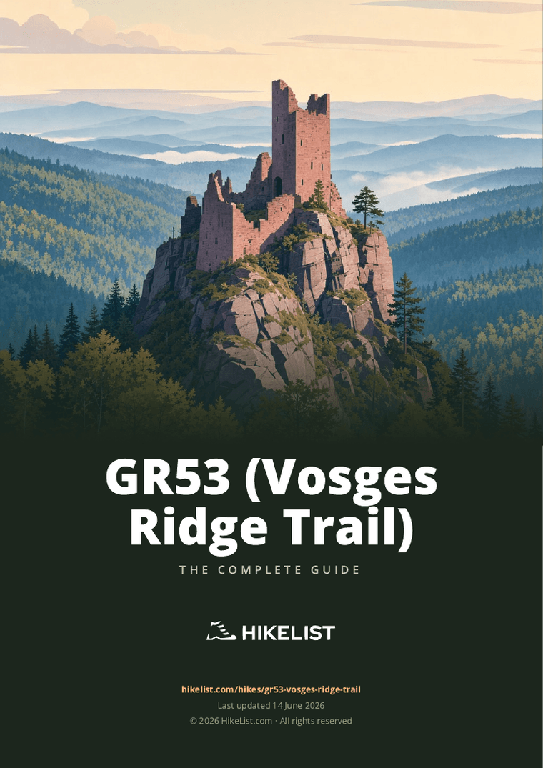
GR53 (Vosges Ridge Trail)
How would you rate GR53 (Vosges Ridge Trail)?
Tap a star to share your experience and help other hikers.
GR53 (Vosges Ridge Trail): Northern Vosges Thru-Hike
HikeList Score
GR53 (Vosges Ridge Trail) scored 87/100 on HikeList's trail-quality metrics.
See score breakdownHide breakdown
- Ideal length 98
- Balanced challenge 84
- Scenery & wildness 85
- Varied terrain 83
- Accommodation 74
- Food & support 88
- Path quality 98
- Season flexibility 89
Computed from length, challenge, scenery & wildness, terrain variety, accommodation, food & support, path quality and season flexibility.
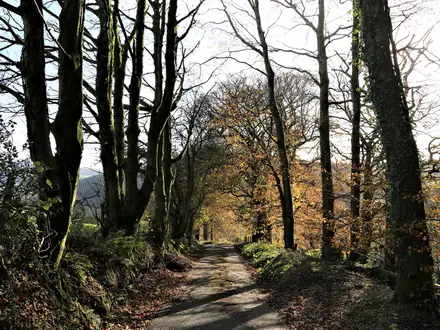
The GR53 is a 165 km point-to-point Grande Randonnée through the Northern Vosges in north-east France, from Wissembourg on the Franco-German border to the Col du Donon / Schirmeck area. Allow about 8 days. It is a hard, non-technical forest and ridge walk: long daily distances, repeated climbs and rocky sandstone paths rather than alpine exposure. It suits hikers who want a waymarked village-to-village route with castles, beech and Scots-pine forest, and reliable access to towns and TER trains.
Route Overview
Walk north to south from Wissembourg through the Parc naturel régional des Vosges du Nord, passing Climbach, Obersteinbach, Niederbronn-les-Bains, Lichtenberg, La Petite Pierre and Saverne before continuing towards Mont Sainte-Odile, the Schneeberg, Le Donon and Schirmeck. The GR53 is linear, waymarked with the Club Vosgien red rectangle, and hands over to the GR5 around the Donon for the continuation south. Both ends and several mid-route towns are on the TER train network, making section hiking practical. For related Alsace walking, compare the lower-level Alsace Vineyard Trail; for the higher southern Vosges, see the Ballons des Vosges Park Trails.
A pioneer route of the Club Vosgien
The route was created by the Club Vosgien, the Vosges walking federation founded in 1872, in 1897 for the club’s 25th anniversary. It originally formed part of a single traverse of the whole Vosges massif from Wissembourg to Belfort. When the modern GR network was formalised, the southern Donon-to-Belfort section became part of the GR5 in 1947, while the northern Wissembourg-to-Donon section became the GR53 in 1950. It remains marked with the Club Vosgien red rectangle.
Notable highlights
- Wissembourg: Historic fortified Alsatian border town on the River Lauter and the northern gateway to the GR53, with the Gothic Saints-Pierre-et-Paul church and an old quarter that makes an easy first overnight stop.
- Parc naturel régional des Vosges du Nord: A UNESCO-designated biosphere reserve and geopark of beech and Scots-pine forest, pink-sandstone crags and quiet wooded ridges.
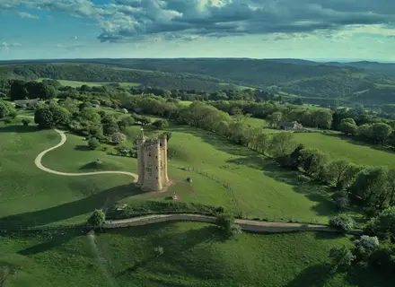
- Medieval sandstone castles: The northern stages pass ruined hill-castles built from local pink sandstone, including Fleckenstein, Lichtenberg and rock-perched fortresses above Obersteinbach.
- Saverne and the Château du Haut-Barr: Saverne is a useful trail town with a pink-sandstone Rohan château; above it, the Château du Haut-Barr stands on sandstone rocks with wide views over the Alsace plain.
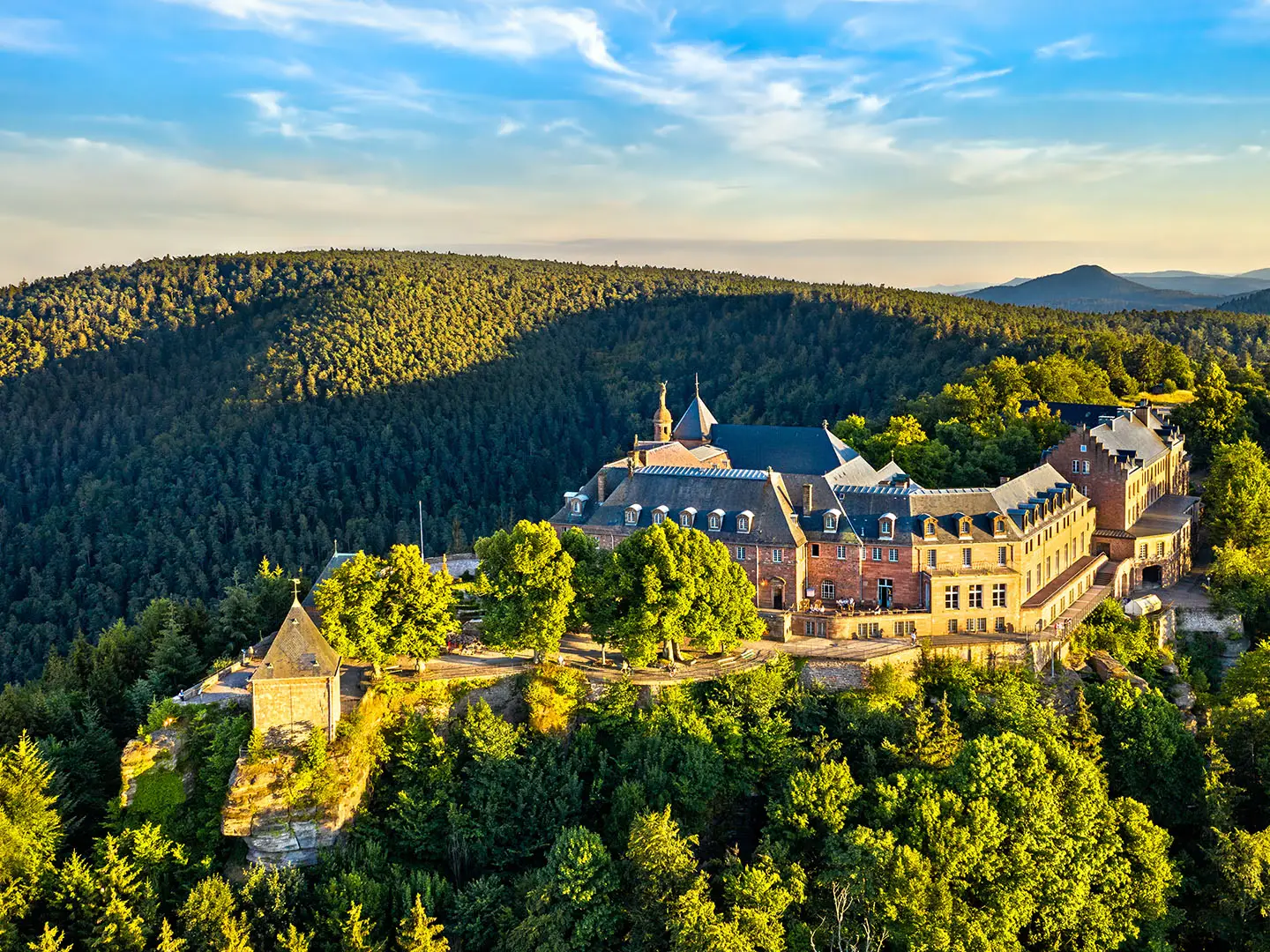
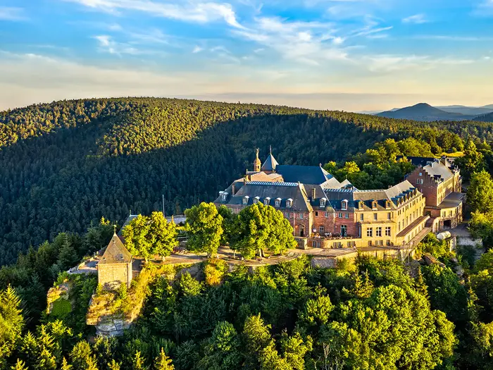
- Mont Sainte-Odile: A clifftop convent and major Alsatian pilgrimage site, ringed by the prehistoric Mur Païen, a dry-stone wall of large blocks.
- Le Donon (1,009 m): The climactic summit near the southern end, with Gallo-Roman temple remains and a 19th-century neoclassical temple on top.
Challenges to expect
Expect cumulative effort more than technical difficulty: about 5,900 m of ascent over 165 km, sustained forest climbs and descents, and rocky pink-sandstone sections that can be slippery in rain. Waymarking is established, but it uses the Club Vosgien red rectangle rather than standard GR paint in places. Accommodation is village-based, so book ahead in smaller settlements. Winter can bring snow on higher sections around Donon and Champ du Feu.
HikeList Score
GR53 (Vosges Ridge Trail) scored 87/100 on HikeList's trail-quality metrics.
See score breakdownHide breakdown
- Ideal length 98
- Balanced challenge 84
- Scenery & wildness 85
- Varied terrain 83
- Accommodation 74
- Food & support 88
- Path quality 98
- Season flexibility 89
Computed from length, challenge, scenery & wildness, terrain variety, accommodation, food & support, path quality and season flexibility.
Show more data Show less
- Mountainous
- Forest
- Hilly
- Dirt
- Rock
- Gravel
- Guesthouses
- Hotels
- Family Friendly
- Pet Friendly
- Restrooms
- Water Sources
- Campsites
- Shelters
- Picnic Areas
Download Our Full Guide to GR53 (Vosges Ridge Trail) FREE!
Get our comprehensive guide to this hike for free. Save it for later reading or print out at home.
Photos from hikers
Taken on the trail by people who've reviewed GR53 (Vosges Ridge Trail).
GR53 (Vosges Ridge Trail): The Complete Guide
 i
Image by Leonid Andronov
i
Image by Leonid Andronov The GR53 is a hard, richly varied traverse of the Northern Vosges, running from Wissembourg on the River Lauter to the Donon area where it meets the GR5. It suits fit, experienced walkers who want a long forest-and-ridge journey rather than an exposed alpine route.
For much of its 165 km, the trail threads beech and Scots-pine woodland, pink-sandstone hills and quiet ridges inside the Parc naturel régional des Vosges du Nord. The character is unmistakably Vosgien: rocky paths, castle crags, wooded summits and small trail towns spaced just far enough apart to make planning matter.
The highlights are practical as well as scenic: Château de Fleckenstein, Grand Wintersberg, Niederbronn-les-Bains, La Petite-Pierre, Saverne and the Château du Haut-Barr, then the higher southern ground around Schneeberg, rocher de Mutzig and Le Donon. The usual finish is not at a railhead on the ridge, but by descending to Schirmeck–La Broque for the train.
This is not a technical walk, but it asks for endurance. Expect repeated climbs and descents, around 5,900 m of total ascent, long forest sections, slippery sandstone after rain and Club Vosgien red-rectangle waymarks rather than the usual GR red-and-white paint.
This guide covers stages, daily planning, accommodation, food, transport, terrain and the common mistakes to avoid.
Stage-by-Stage Guide
Stage 1: Wissembourg to Obersteinbach — 29 km
This is a long opening stage and should be treated as a full hill day, not a gentle introduction. The GR53 leaves Wissembourg, the fortified border town on the River Lauter, then works south through the wooded sandstone country of the Northern Vosges via Rott, Climbach and Petit-Wingen.
The walking is mostly forest tracks, rooty paths and sandstone paths, with repeated small climbs and descents rather than one single mountain ascent. The main landmark is Château de Fleckenstein, a striking ruined fortress built into a pink-sandstone rock outcrop, before the route continues to Obersteinbach.
Food and water planning should be conservative. Wissembourg is the place to start fully supplied; the route passes villages, but opening hours and services in the smaller settlements should not be relied on without checking ahead.
Obersteinbach is a village-based overnight stop, with accommodation choice thinner than in the larger towns. Book ahead, especially if walking in the main spring-to-autumn season or over weekends.
Wissembourg has an SNCF station and is the usual arrival point for the trail. Obersteinbach has road access but no rail access is specified for the route, so transport out from here should be arranged in advance if ending a section.
Navigation is generally straightforward if you follow the Club Vosgien red rectangle, but do not look for the standard red-and-white GR paint. Around castle rocks and sandstone crags, expect rougher ground and take extra care after rain, when the rock can be slippery.
Stage 2: Obersteinbach to Niederbronn-les-Bains — 16 km
This is a shorter stage on paper, but it remains hilly and wooded. From Obersteinbach the route continues through the sandstone forest landscape towards Windstein and then climbs towards the Grand Wintersberg before descending to Niederbronn-les-Bains.
Grand Wintersberg, at 581 m, is the highest summit of the Northern Vosges and has an observation tower. In clear weather this is one of the best viewpoints on the northern part of the GR53.
The path underfoot is typical Northern Vosges terrain: forest trail, gravel, roots and rocky sandstone sections. The descent towards Niederbronn-les-Bains can feel tougher than the distance suggests, particularly in wet conditions.
Carry enough food and water from Obersteinbach unless services have been checked in advance. Niederbronn-les-Bains is the dependable end-of-stage town for accommodation, resupply and onward logistics.
Niederbronn-les-Bains is rail-served, making this one of the easiest places to start, finish or break the route. It is also a useful place to adjust plans after the long first day.
Navigation remains on the red rectangle waymarks. The main warning for this stage is not exposure but wet sandstone and tired legs on the descent, especially if the previous day was walked in full.
Stage 3: Niederbronn-les-Bains to Lichtenberg — 19 km
This stage leaves the rail-served spa town of Niederbronn-les-Bains and returns to quieter forest and sandstone hill country. The nearby ruined Château du Wasenbourg is one of the local landmarks associated with Niederbronn before the route continues south-west towards Lichtenberg.
The walking is non-technical but constantly rolling. Expect forest paths, stony tracks and occasional rocky sections, with the usual Vosges pattern of climbing out of settled valleys and dropping back towards villages.
Lichtenberg is dominated by its hilltop château, a fortress remodelled as an artillery castle. It makes a strong end point, but it is a smaller settlement than Niederbronn-les-Bains, so accommodation and evening food should be booked or checked before arrival.
Start the day with food and water from Niederbronn-les-Bains. Do not assume that every intermediate village has open shops or restaurants at the time you pass through.
Niederbronn-les-Bains has TER access. Lichtenberg has road access; for rail-based section planning in this part of the route, nearby TER towns such as Wingen-sur-Moder or Ingwiller may be useful, but local connections and transfer options should be checked before travelling.
Keep close attention to the Club Vosgien red rectangle where forest tracks branch. The difficulty is mainly endurance and route discipline rather than technical terrain.
Stage 4: Lichtenberg to La Petite-Pierre — 17 km
This is a compact but rewarding stage through the heart of the Vosges du Nord forest landscape. From Lichtenberg the GR53 continues via Wimmenau and Erckartswiller towards the hilltop village of La Petite-Pierre.
The terrain remains wooded and undulating, with a mix of forest tracks, narrower paths and sandstone underfoot. It is generally good walking, but the repeated rises and descents make the stage more demanding than a lowland 17 km.
La Petite-Pierre is one of the classic bases of the Northern Vosges, with its château and long association with the regional park. It is a logical overnight stop and a good place to reset before the route turns towards Saverne.
Food and water should be planned around the start and finish unless current services in the villages en route have been checked. In smaller places, opening days and hours can be the limiting factor rather than distance.
Accommodation is available in and around La Petite-Pierre, but it should still be booked ahead. The GR53 is village-based rather than hut-to-hut in the Alpine sense, and beds in smaller settlements can be limited.
Public transport is less straightforward than at the main rail towns. If using this stage as a section, plan the road transfer or nearby rail access before committing to dates.
Stage 5: La Petite-Pierre to Saverne — 20 km
This stage links one of the Northern Vosges' best-known hill villages with the major trail town of Saverne. The route passes through forest and the settlement of Graufthal before dropping towards Saverne and the edge of the Alsace plain.
Underfoot, expect more sandstone paths, forest tracks and rooty sections. The walking is not technically difficult, but the cumulative effort of the previous days often starts to show here.
Saverne is a key logistical stop on the GR53. The town has its pink-sandstone Rohan château, good onward transport and more accommodation choice than the smaller villages.
The main highlight above Saverne is Château du Haut-Barr, reached on the continuation of the route out of town on the next stage. If arriving early and staying in Saverne, it is worth planning how that climb fits into the following morning rather than underestimating it.
Carry food and water from La Petite-Pierre and do not rely on intermediate services unless checked. Saverne is the most dependable place on this stage for resupply and overnight logistics.
Saverne has TER rail access, making it one of the best places to split the GR53. Navigation into a larger town can be less intuitive than in open forest, so keep following the red rectangle until the route is clearly finished for the day.
Stage 6: Saverne to Wangenbourg-Engenthal — 24 km
This is a substantial stage leaving a major trail town and returning to long forest walking. The route climbs from Saverne to Château du Haut-Barr, known as the eye of Alsace, before continuing through sandstone ridges and woodland towards Wangenbourg-Engenthal.
The climb to Haut-Barr is one of the signature moments of the route, with the castle standing on sandstone rocks and wide views over the Alsace plain in good weather. After that, the day becomes more remote-feeling, with extended forest sections.
Terrain is mostly forest path and track, with rocky sandstone around the castle and ridges. Wet rock can be slippery, and the stage is long enough that an early start is sensible.
Saverne is the place to leave fully supplied. Once away from town, food and water options should be treated as uncertain unless checked with accommodation providers or local services beforehand.
Wangenbourg-Engenthal is a village-based overnight stop, so book accommodation in advance. Do not assume the same range of services available in Saverne.
Saverne has excellent rail access for starting or ending a section. Wangenbourg-Engenthal is reached by road rather than by a rail stop specified for the trail, so any transfer should be arranged before walking.
Navigation is normally clear on Club Vosgien waymarks, but there are many forest tracks in this part of the Vosges. At junctions, confirm the red rectangle rather than simply following the broadest track.
Stage 7: Wangenbourg-Engenthal to Oberhaslach — 23 km
This stage marks the transition into the higher southern end of the GR53. From Wangenbourg-Engenthal the route heads towards the Schneeberg area, then passes the Château et cascade du Nideck before continuing to Oberhaslach.
The day has a rougher, more upland feel than many earlier stages. Higher ground, forested gorges, rocky paths and sandstone features make it one of the more physically demanding sections.
The Nideck waterfall and ruined castles are the key highlights. Paths around gorges, wet rock and shaded woodland can be slippery, especially after rain or in autumn leaf fall.
Food and water should be carried from Wangenbourg-Engenthal. There may be settlements and road access in the wider area, but the walking day should be planned as a self-sufficient forest stage unless current services have been checked.
Oberhaslach is the normal end point for this stage and has accommodation options in the village-based style of the route. Book ahead, as the next day is long and high, and starting without a confirmed bed or onward plan is poor practice.
Public transport is not as simple here as at Saverne or Niederbronn-les-Bains. Road access exists, but walkers using this as a section break should check transfers before travelling.
The main warnings are fatigue, slippery sandstone and careful navigation through forest junctions. There is no serious exposure, but the combination of distance, ascent and rougher ground makes this a hard stage.
Stage 8: Oberhaslach to Le Donon / Schirmeck — 25 km
The final stage is one of the biggest days of the GR53 and reaches the highest ground of the trail. From Oberhaslach the route heads through the southern forest via Urmatt towards the rocher de Mutzig, the Col de l'Engin and Le Donon, before most walkers continue down to Schirmeck for rail access.
The rocher de Mutzig, at 1,010 m, is fractionally the highest point on the GR53. Le Donon, at 1,009 m, is the iconic summit close by, with Gallo-Roman temple remains and a 19th-century neoclassical temple.
This is the most mountain-like part of the route, with higher, more open ground near the southern summits. Expect sustained climbing, rocky sandstone paths, forest tracks and a long final descent if finishing at Schirmeck.
Start early and carry enough food and water for the full day. Do not rely on finding supplies on the high section around the rocher de Mutzig, Col de l'Engin or Le Donon.
The GR53 proper ends near the Col de l'Engin / Donon area, where it hands over to the GR5. The high end has no railway, so most walkers finish by descending to Schirmeck–La Broque, the nearest rail-served town.
Accommodation or onward transport at Schirmeck should be arranged before setting off, particularly if arriving late after the full stage. Schirmeck–La Broque is on the Strasbourg–Saint-Dié TER line, but current train times and any replacement buses should be checked before travelling.
Navigation needs attention at the GR53–GR5 handover and on the chosen descent to Schirmeck. The stage is non-technical, but weather, wet rock and end-of-walk fatigue can make the final high section feel serious.
Recommended Itinerary
Standard 8-day itinerary
This is the most practical full-route schedule for fit walkers: long enough to keep daily distances manageable, but still direct enough to complete the GR53 in just over a week. The key planning issue is not the waymarking — the Club Vosgien red rectangle is generally clear — but matching stages to villages with accommodation.
| Day | From | To | Approx. distance | Why this stage makes sense | Services/accommodation notes |
|---|---|---|---|---|---|
| 1 | Wissembourg | Obersteinbach | 29 km | A long opening stage that gets you fully into the Northern Vosges forest and sandstone-castle country, passing the northern hills and the Château de Fleckenstein area before reaching a natural overnight stop. | Wissembourg is the easiest starting base, with TER access. Obersteinbach is a small settlement, so book accommodation ahead and do not assume late availability. |
| 2 | Obersteinbach | Niederbronn-les-Bains | 16 km | A shorter recovery day after the big start, with wooded ridges, castle remains and the Grand Wintersberg area before descending towards a rail-served spa town. | Niederbronn-les-Bains is one of the most useful stops on the route, with TER access and a better choice of services than the smaller forest villages. |
| 3 | Niederbronn-les-Bains | Lichtenberg | 19 km | A steady mid-length stage through the forested northern section, finishing at the hilltop fortress village of Lichtenberg. | Lichtenberg is a smaller overnight stop; accommodation choice is limited compared with Niederbronn-les-Bains or Saverne. Book before committing to this split. |
| 4 | Lichtenberg | La Petite-Pierre | 17 km | A moderate day that keeps the itinerary balanced and avoids turning the central section into one overlong push. La Petite-Pierre is a logical trail base with strong Club Vosgien associations. | La Petite-Pierre has accommodation, but it is still worth booking ahead, especially in holiday periods. Services between villages can be sparse. |
| 5 | La Petite-Pierre | Saverne | 20 km | A classic central stage through the sandstone hills and forest, descending towards Saverne after the Graufthal area. Saverne is the key resupply and transport stop before the harder southern half. | Saverne has TER access and a wider range of accommodation and services. This is the best place on the itinerary for a restock, laundry or a planned break. |
| 6 | Saverne | Wangenbourg-Engenthal | 24 km | A substantial stage climbing out past the Château du Haut-Barr and continuing into quieter wooded country. It marks the transition from the northern castle stages into the more sustained ridge-and-forest walking of the south. | Wangenbourg-Engenthal is an important overnight stop before the higher southern stages. Book ahead, as alternatives are not as frequent as in larger towns. |
| 7 | Wangenbourg-Engenthal | Oberhaslach | 23 km | A demanding but logical day over the southern forest ridges, taking in the Schneeberg and the Nideck area before dropping to Oberhaslach. | Oberhaslach is a practical final village stop before the high ground around the rocher de Mutzig, Col de l’Engin and Le Donon. Confirm accommodation and food options before travelling. |
| 8 | Oberhaslach | Le Donon / Schirmeck | 25 km | A tough final stage over the highest ground of the GR53, including the rocher de Mutzig and the Donon area. The GR53 proper ends near the Col de l’Engin / Le Donon, but most walkers continue down to Schirmeck for the railway. | There is no railway at the high southern end, so plan the descent to Schirmeck–La Broque or arrange local transport. TER times and any bus options should be checked before travelling. |
Slower variant
A 9–10 day schedule is sensible if you want shorter days, more time for castle visits, or a lower-risk plan in wet weather when the pink sandstone can be slippery. The stages most worth shortening are the long opening day from Wissembourg to Obersteinbach, the Saverne to Wangenbourg-Engenthal section, and the final Oberhaslach to Le Donon / Schirmeck day.
Possible intermediate places on or near the route include Rott, Climbach, Petit-Wingen, Windstein, Wimmenau, Erckartswiller, Graufthal, Urmatt and the Donon area, but bed availability varies and should not be assumed. Use these only where accommodation or transfers have been arranged; check official mapping before booking.
This slower version suits walkers who are fit enough for the GR53 but do not want repeated 20 km-plus days with sustained ascent. It also works well for hikers carrying heavier packs or travelling outside peak season, when shorter daylight and limited opening days can affect plans.
Faster variant
A 6–7 day crossing is possible for very fit, efficient walkers who are comfortable with long forest days and repeated climbs. The most straightforward way to make the route faster is to combine one or more of the shorter middle stages, especially around Niederbronn-les-Bains, Lichtenberg and La Petite-Pierre, while keeping Saverne and Schirmeck as major transport anchors.
Do not plan a faster itinerary purely from the total distance. The GR53 has about 5,900 m of ascent, rooty and rocky forest paths, and sandstone sections that slow down in wet conditions. Accommodation spacing is also a real constraint, so each combined day should be checked against actual beds and food options before booking.
The faster version suits experienced long-distance hikers travelling light, starting early and already comfortable with Club Vosgien waymarking. It is a poor choice for a first multi-day walk in the Vosges or for anyone relying on flexible, last-minute accommodation in the smaller villages.
Planning the Route
How many days to allow
Most walkers should plan the GR53 as an 8-day walk. That gives a realistic rhythm between the main accommodation villages without turning every day into a forced march, while still keeping the itinerary compact.
A faster 6–7 day crossing is possible for very fit walkers, but it leaves little margin for wet sandstone, forest navigation, late starts or accommodation constraints. A slower 9–10 day plan is often better if you want time for the castles, spa towns and viewpoints, or if you prefer shorter days on repeated climbs and descents.
The key planning point is that the route is not shaped by campsites or high mountain huts; it is shaped by where there are actual beds. The obvious overnight stops are Wissembourg, Obersteinbach, Niederbronn-les-Bains, Lichtenberg, La Petite-Pierre, Saverne, Wangenbourg-Engenthal, Oberhaslach and then Schirmeck after descending from the Donon area.
Stage planning and accommodation
The standard 8-day split works because it links the main trail settlements, but it is not perfectly even. The first day from Wissembourg to Obersteinbach is long, while the second day to Niederbronn-les-Bains is shorter. Later stages remain consistently hilly, with the southern end becoming higher and more strenuous around Schneeberg, rocher de Mutzig, Col de l'Engin and Le Donon.
Accommodation is the main constraint. Larger trail towns such as Wissembourg, Niederbronn-les-Bains, La Petite-Pierre, Saverne and Schirmeck are more practical bases, while smaller places can have limited choice. Book beds before fixing transport, especially if walking in holiday periods or relying on specific gîtes, chambres d'hôtes or auberges.
Some Club Vosgien refuges and shelters exist along the route, but they should not be treated as a guaranteed substitute for booked accommodation unless their current access, opening arrangements and facilities have been checked before travelling.
Shortening, extending and section hiking
The GR53 is unusually practical for section hiking because several useful trail towns are connected to the TER network. Wissembourg is the normal rail-served start, Niederbronn-les-Bains and Saverne make strong intermediate access points, and Schirmeck–La Broque is the usual rail-served finish after the Donon area.
This makes it straightforward to split the route into northern, central and southern blocks. Saverne is the most obvious break point for many walkers because it is a substantial town and sits roughly between the castle-and-forest northern half and the higher southern approach towards the Donon.
The one transport complication is the official high finish around Col de l'Engin / Le Donon. There is no railway at the col, so most walkers plan the final day to include the descent to Schirmeck, or arrange local onward transport separately. Current TER times and any rail-replacement bus arrangements should be checked before travelling.
Food and water planning
Do not assume every small settlement on the GR53 has reliable daytime food options. Plan around the larger trail towns, carry lunch and emergency snacks, and check opening days for shops, bakeries, restaurants and accommodation meals before setting off.
Water planning is similar. The walk spends long periods in forest and on sandstone ridges, so refill whenever there is a dependable opportunity in villages or at accommodation. In warm weather, carrying enough for a full stage is more sensible than relying on finding water between settlements.
Navigation and waymarking
The GR53 is well waymarked, but it is marked with the Club Vosgien red rectangle rather than the usual French GR red-and-white paint. This matters because the Northern Vosges have a dense network of Club Vosgien paths, often with different symbols at the same junctions.
Carry the FFRandonnée topo-guide and/or Club Vosgien mapping, and consider using an offline GPX track as a back-up. Pay particular attention when leaving towns, around castle spurs and at forest-road junctions, where several marked paths can diverge in quick succession.
Weather and terrain margins
The route is non-technical, but wet sandstone changes the pace of the walk. Rocky slabs, steps, roots and short scrambly sections around the crags and castle rocks can become slippery after rain, so daily timings should include a margin rather than assuming fast progress on every forest path.
Spring, summer and autumn are the main walking seasons. The southern end reaches the higher ground around rocher de Mutzig and Le Donon, so conditions there can feel more exposed and cooler than the lower forest stages. Weather forecasts and any forestry or diversion notices should be checked before travelling.
Towns, Villages and Overnight Stops
The GR53 is best planned as a village-based walk. The reliable overnight framework is Wissembourg, Obersteinbach, Niederbronn-les-Bains, La Petite-Pierre, Saverne, Wangenbourg-Engenthal and Oberhaslach, with Schirmeck normally used as the rail-served finishing town after the Donon area.
Smaller places on the line of the route can be useful for meals, water, short breaks or adjusting a stage, but they should not be assumed to have beds or evening food. Accommodation, restaurant opening days and any luggage-transfer or taxi arrangements should be checked before travelling, especially outside the main summer holiday period.
Club Vosgien refuges and shelters exist in the wider area, but they are not a like-for-like substitute for a booked gîte, hotel or chambre d’hôtes unless they have been specifically planned into the itinerary. For most walkers, the limiting factor on the GR53 is not finding villages, but matching long forest stages to places that actually have an available bed and food at the end of the day.
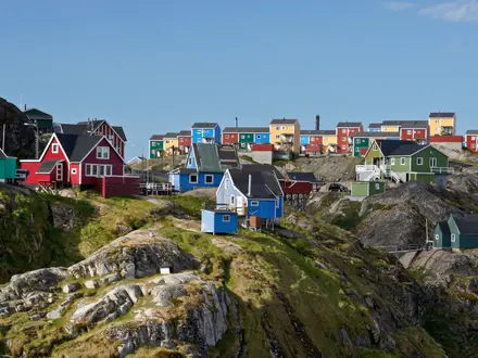
Wissembourg
Wissembourg is the northern start of the GR53, on the River Lauter close to the German border. The Club Vosgien red-rectangle waymarks lead south out of the fortified old quarter, and the SNCF station is the usual arrival point for walkers starting the route.
It is the most straightforward place to spend the night before the first stage. Hotels, guesthouses and other town accommodation are available, and it is a sensible place to sort out food, cash and any last-minute supplies before entering the more thinly served forest-and-village sections.
The first common stage to Obersteinbach is long, so an early start from Wissembourg is useful. If arriving by train on the same morning, check whether there is enough daylight and margin for the 29 km stage before committing to it.
Rott, Climbach and Petit-Wingen
These smaller settlements come early in the walk south of Wissembourg. They are useful route markers on the first stage, but they should not be treated as guaranteed overnight bases unless accommodation has been booked in advance.
Food and café availability in small villages can be limited and opening hours may not suit a through-hiker’s schedule. Carry enough food from Wissembourg to reach the booked overnight stop rather than relying on finding lunch or dinner en route.
Château de Fleckenstein
Château de Fleckenstein is a major landmark on the northern GR53, set on a pink-sandstone rock outcrop near Lembach. It is a highlight rather than a normal overnight stop, and it sits within a long first-day stage if walking Wissembourg to Obersteinbach.
Do not plan food or accommodation around the château unless specific current services have been checked. For walkers on a tight schedule, it is best treated as a sightseeing stop that must still leave enough time for the onward forest walking to Obersteinbach.
Obersteinbach
Obersteinbach is the usual first overnight stop on the common eight-day split, after the long stage from Wissembourg. It is one of the named accommodation villages on the route, with guesthouse, gîte or auberge-style options rather than the breadth of choice found in larger towns.
Book ahead here. The village works well logistically only if the chosen accommodation can provide or point you to an evening meal, as arriving late after a 29 km day leaves little room for improvisation.
There is no rail link noted for Obersteinbach in the route information, so it is not as convenient for starting or stopping a section as Wissembourg, Niederbronn-les-Bains, Saverne or Schirmeck. It is primarily a walking-stage stop.
Windstein and Grand Wintersberg
Windstein and the Grand Wintersberg area sit between Obersteinbach and Niederbronn-les-Bains. This is a shorter stage in the standard split, but it still crosses wooded and hilly ground, with Grand Wintersberg forming a notable high point of the Northern Vosges before the descent towards Niederbronn-les-Bains.
These are better thought of as route landmarks than default overnight stops. If planning a non-standard split in this area, accommodation and transport arrangements should be checked before travelling.
Niederbronn-les-Bains
Niederbronn-les-Bains is one of the most useful stops on the northern half of the GR53. It is a spa town, a convenient overnight base and one of the rail-served trail towns, making it practical for both through-hikers and section-hikers.
Accommodation choice is better here than in the small forest villages, and it is a sensible place to resupply, eat properly and reset after the opening two days. The nearby ruined Château du Wasenbourg is an additional local landmark, but the main practical value is the combination of beds, town services and TER access.
For section-hiking, Niederbronn-les-Bains is one of the easiest points to enter or leave the trail. TER times and any replacement bus arrangements should be checked before travelling.
Lichtenberg
Lichtenberg is a common overnight target in the eight-day split, reached from Niederbronn-les-Bains after about 19 km. The village is known for its hilltop château, which is one of the major fortress landmarks on the route.
Because Lichtenberg is smaller than the main rail-served towns, do not leave accommodation or dinner to chance. Beds and meal options should be booked or confirmed in advance, and walkers should have a fall-back plan if using a different stage length.
There is no rail link specified for Lichtenberg in the route information. It is therefore a practical walking stop if booked, but not one of the easiest places for public-transport access.
Wimmenau and Erckartswiller
Wimmenau and Erckartswiller lie on the route between Lichtenberg and La Petite-Pierre. They are useful intermediate places for pacing the day, but they are not listed among the main accommodation bases for the GR53.
Treat services here as uncertain unless checked directly. Carry food for the stage and avoid planning a critical resupply around a small village shop or café without verifying opening times.
La Petite-Pierre
La Petite-Pierre is one of the key overnight towns of the central GR53. It is a hilltop village with its own château and a long association with the Vosges du Nord park, and it makes a natural stop after the Lichtenberg stage.
For hikers, its main value is practical: it is a recognised base with accommodation options and a good place to pause before the next section to Saverne. As with all smaller hill towns, book ahead and check evening food arrangements, particularly midweek or outside peak season.
La Petite-Pierre is also a sensible place to adjust the itinerary if the earlier forest stages have taken longer than expected. It gives a more substantial stop before the route continues through Graufthal towards Saverne.
Graufthal
Graufthal sits between La Petite-Pierre and Saverne. It is best treated as an intermediate route point rather than a primary overnight stop on the standard schedule.
The La Petite-Pierre to Saverne stage is around 20 km, so most walkers will pass through or near Graufthal during the day and continue to Saverne for the night. Any plan to stop here should be based on pre-booked accommodation and checked food availability.
Saverne
Saverne is one of the most important logistics points on the GR53. It is a key trail town with a railway station, accommodation and town services, and it sits roughly where many walkers mentally divide the northern and southern halves of the route.
This is one of the best places to resupply, take a proper meal, replace worn items if needed and split the walk into sections. It is also a practical exit or entry point for walkers using the TER network.
The Château du Haut-Barr stands above Saverne and is normally visited as part of the onward route rather than as an overnight base. After leaving Saverne, the next standard stop is Wangenbourg-Engenthal, so make sure food and accommodation are organised before starting that longer forest stage.
Château du Haut-Barr
Château du Haut-Barr is a major sandstone-castle highlight above Saverne, with wide views over the Alsace plain. It is a landmark on the walking day out of Saverne, not a substitute for the services of the town below.
Plan the visit around the onward mileage to Wangenbourg-Engenthal. If spending extra time at the château, leave enough margin for the remaining forest walking and any check-in or dinner time at the booked accommodation.
Wangenbourg-Engenthal
Wangenbourg-Engenthal is the standard overnight stop after Saverne on the common eight-day itinerary. It is one of the named accommodation bases on the GR53 and is important because the surrounding section is long, wooded and less forgiving of poor planning.
Book accommodation ahead and confirm evening food. This is not a rail-served stop in the route information, so it is less convenient for section access than Saverne or Schirmeck and is best planned as a committed walking-stage destination.
The next stage crosses the Schneeberg and continues towards the Nideck area and Oberhaslach. Weather, wet sandstone and fatigue can slow this southern half of the route, so leaving Wangenbourg-Engenthal with food and a clear booking for the night matters.
Schneeberg and the Nideck area
Schneeberg and the Château et cascade du Nideck sit on the southern half of the GR53 between Wangenbourg-Engenthal and Oberhaslach. This is a more upland, forested section and includes one of the route’s classic waterfall-and-castle settings.
These are route highlights rather than normal overnight bases. Services should not be assumed in the forest or around the landmark itself; carry what is needed for the day and continue to a booked stop such as Oberhaslach unless a specific alternative has been arranged.
Oberhaslach
Oberhaslach is the standard overnight stop before the final high section towards the rocher de Mutzig, Col de l’Engin, Le Donon and the descent towards Schirmeck. It is one of the named accommodation villages for the GR53, and it is an important place to be properly fed and rested before the last demanding day.
Accommodation choice is likely to be thinner than in Saverne or Niederbronn-les-Bains, so booking ahead is important. Confirm whether dinner is available at or near the accommodation, and carry food for the following day’s long southern stage.
This is also a logical place to reassess conditions. Wet sandstone, forest paths and cumulative fatigue can make the final day slower than the distance alone suggests.
Urmatt
Urmatt appears on the route after Oberhaslach and before the final climb towards the rocher de Mutzig and Donon area. It can be relevant for walkers adjusting the last stage, but the route information does not identify it as one of the main accommodation or rail-planning hubs.
Any plan to overnight, resupply or leave the trail at Urmatt should be checked before travelling. Do not assume that it offers the same logistical certainty as Saverne, Niederbronn-les-Bains or Schirmeck.
Rocher de Mutzig, Col de l’Engin and Le Donon
The rocher de Mutzig and Le Donon form the high southern end of the GR53, with the Col de l’Engin marking the area where the GR53 hands over to the GR5. This is a high, exposed-by-comparison finish to a route that has otherwise spent much of its time in forest.
The key planning point is that the high Donon / Col de l’Engin area has no railway station. Walkers usually continue or descend to Schirmeck–La Broque for the nearest rail access, or arrange local bus or road transport in advance.
Do not treat the col as a simple public-transport finish unless the onward connection has been checked. If ending the walking day at Schirmeck, allow for the extra descent and keep enough food, water and daylight for the full finish rather than stopping mentally at Le Donon.
Schirmeck
Schirmeck is the usual practical finish for GR53 walkers because it is the nearest rail-served town to the Donon end of the route. Schirmeck–La Broque is on the Strasbourg–Saint-Dié TER line, making it the natural exit point for car-free walkers.
It is also the sensible place to book a final night if the last stage from Oberhaslach is too long to combine comfortably with onward travel. Train times, replacement buses and late-day connections should be checked before travelling.
For section-hikers, Schirmeck pairs well with Wissembourg, Niederbronn-les-Bains and Saverne as one of the main public-transport anchors of the GR53. The important distinction is that the GR53’s high end near the Donon is not itself rail-served; Schirmeck is the logistical finish.
Getting to the Start
By train
Wissembourg SNCF station is the usual arrival point for the GR53. The trail begins in the fortified old quarter of Wissembourg, on the River Lauter, with the Club Vosgien red-rectangle waymarks leading south out of town.
The route is well suited to car-free travel because Wissembourg is on the TER network, and later trail towns such as Niederbronn-les-Bains and Saverne also have rail access. For end-to-end walkers, the usual finish is to descend from the Donon / Col de l’Engin area to Schirmeck–La Broque, which has a station on the Strasbourg–Saint-Dié TER line.
Train times, engineering works and TER rail-replacement buses can affect this region, especially for early starts or Sunday travel. This should be checked before travelling.
By bus
Bus access is secondary to rail for starting the GR53. Local services may be useful for short links or for joining the route at intermediate villages, but Wissembourg station is the simplest and most reliable starting access for most walkers.
If planning to begin somewhere other than Wissembourg, check the current local bus timetable before building a stage around it. This should be checked before travelling.
By car
Driving to Wissembourg is possible, but the GR53 is a point-to-point walk and the practical finish is at Schirmeck–La Broque, not back at the start. Unless a vehicle shuttle is arranged, car-free travel is usually simpler than leaving a car in Wissembourg for the full traverse.
Do not assume long-stay parking is available or permitted at the station or in the centre without checking locally. Parking rules, maximum stay limits and any charges should be checked before travelling.
For section-hikers, using TER stations such as Wissembourg, Niederbronn-les-Bains, Saverne and Schirmeck–La Broque is usually more practical than moving a car between forest villages.
From the nearest airport
No airport is directly on the trail. The practical approach is to fly into an airport with onward access to the French rail network, then continue by SNCF / TER to Wissembourg.
Allow a buffer if arriving by air on the same day, as a missed connection can make it difficult to start the first stage sensibly. Current rail connections from the chosen airport should be checked before travelling.
Where to stay before starting
Wissembourg is the best place to stay the night before starting. It has the advantage of rail access, services, and immediate access to the GR53 start in the old town.
Staying in Wissembourg is especially sensible if following the common first stage to Obersteinbach, which is a long opening day of around 29 km. Arriving the evening before avoids beginning the walk after a late train and gives time to check waymarks, food and onward accommodation.
Book accommodation ahead, particularly in busy periods or if starting on a weekend. The GR53 is village-based, but beds can thin out quickly once the route leaves the larger towns.
Getting Home from the Finish
The GR53 proper ends high in the Col de l'Engin / Le Donon area, where it meets the GR5. There is no railway at the col, so most walkers finish by descending to Schirmeck–La Broque, the nearest rail-served town and the practical end point for public transport.
Do not plan the final day as if the Donon itself were a transport hub. If the weather is poor, the sandstone is wet, or the final ridge takes longer than expected, the safest plan is to continue to Schirmeck–La Broque and stay overnight rather than rely on an uncertain late connection from the col.
By train
Schirmeck–La Broque is the key station for leaving the southern end of the GR53. It sits on the Strasbourg–Saint-Dié TER line, giving a straightforward rail exit once the descent from Le Donon / Col de l'Engin has been completed.
For most onward journeys, Strasbourg is the main rail hub to aim for. From there, connections continue into the wider French rail network and back towards Alsace, including journeys that can be used to return towards the start at Wissembourg with the appropriate TER changes.
TER times are timetable-dependent and some rail services can be replaced by SNCF buses. Check current times before committing to a final-day plan, especially on Sundays, public holidays or if aiming for a same-day long-distance connection.
By bus
The high southern end around Col de l'Engin / Le Donon has no station, and any local bus option should be treated as limited rather than assumed. A bus may be useful if finishing directly at the Donon area rather than walking down to Schirmeck, but routes, operating days and seasonal patterns can change.
This should be checked before travelling. If a same-day departure matters, plan around the train from Schirmeck–La Broque rather than an unconfirmed bus from the pass.
By car/taxi
A pre-arranged taxi can be useful for walkers ending at Col de l'Engin / Le Donon, for tired groups, or for anyone who does not want to add the descent to Schirmeck at the end of the route. Do not expect taxis to be waiting at the col.
Book ahead, agree the exact pick-up point, and allow for poor mobile signal in forested areas. If meeting a driver at Le Donon or Col de l'Engin, carry enough battery and offline mapping to reach the agreed road access point without improvising late in the day.
For a car shuttle, Schirmeck–La Broque is usually the more practical collection point than the high finish, because it has the station and town services. Leaving a vehicle at one end and returning by TER is possible in principle, but parking rules and train times should be checked before travelling.
From the nearest airport
The practical public-transport exit is first to reach Schirmeck–La Broque station, then travel by TER towards Strasbourg for onward connections. Airport choice depends on the wider journey and flight availability, so do not build a plan around an airport transfer until the current rail and airport-link timings have been checked.
If flying out the same day, leave a generous buffer. The final GR53 stage includes high ground around rocher de Mutzig and Le Donon, and delays from wet sandstone, fatigue or navigation at the GR53/GR5 junction can make tight evening travel unrealistic.
Where to stay at the finish
Staying in or near Schirmeck–La Broque is the simplest finish strategy if the final stage may run late. It avoids depending on the last TER after a long mountain day and makes the following morning's rail journey much easier.
Accommodation choice is thinner than in larger cities, so book ahead rather than arriving without a plan. If splitting the final section, Oberhaslach and Urmatt are the preceding settlements on the route, but the cleanest transport finish remains Schirmeck–La Broque.
Which Direction Should You Walk?
The GR53 is best walked north to south, from Wissembourg to the Col de l'Engin / Le Donon area, then down to Schirmeck. This is the standard and most natural direction: the route starts in Wissembourg, the Club Vosgien red-rectangle line leads south through the Northern Vosges, and the GR53 proper finishes near Le Donon where it meets the GR5.
Reverse walking is possible, especially for section-hikers using the TER network, but it is less tidy as a full-route itinerary.
North to south: Wissembourg to Le Donon / Schirmeck
This direction gives the most logical progression. The route begins with the lower sandstone castles and forest ridges around Wissembourg, Château de Fleckenstein, Obersteinbach, Windstein and Niederbronn-les-Bains, then builds gradually towards the more sustained southern hills around Wangenbourg-Engenthal, Schneeberg, Oberhaslach, rocher de Mutzig and Le Donon.
It also gives the strongest psychological finish. Reaching the high ground around rocher de Mutzig and Le Donon feels like a proper culmination after a week of forest-and-ridge walking, and the junction with the GR5 gives the end of the GR53 a clear long-distance-trail logic.
Transport is straightforward. Wissembourg has an SNCF station and is the usual arrival point; at the southern end, the GR53 itself ends high near the Donon area, but most walkers continue down to Schirmeck–La Broque for the TER station. Check current TER times before travelling, as services can change or be replaced by buses.
Accommodation planning also works well in this direction because the common stage sequence naturally links the main trail stops: Wissembourg, Obersteinbach, Niederbronn-les-Bains, Lichtenberg, La Petite-Pierre, Saverne, Wangenbourg-Engenthal, Oberhaslach and then the Schirmeck finish. Beds are still limited in smaller settlements, so the direction does not remove the need to book ahead.
South to north: Schirmeck / Le Donon to Wissembourg
Walking in reverse can suit hikers who want to finish at Wissembourg, where the railway station is directly in the trail town. It can also work well if accommodation availability forces a reversed itinerary, or if section-hiking plans are built around Schirmeck, Saverne or Niederbronn-les-Bains.
The main drawback is that the route begins with the highest and most demanding southern ground. Instead of building towards rocher de Mutzig and Le Donon, you tackle the bigger forest climbs early, then move north into the lower castle-and-sandstone country. Some walkers will like getting the high section done first; others will find it a harder start.
The finish in Wissembourg is practical but less dramatic. It is an attractive and convenient end point, but it lacks the same sense of reaching the crest and joining the GR5 at the Donon end.
Navigation should still be manageable because the GR53 is waymarked, but remember that the route uses the Club Vosgien red rectangle, not the standard GR red-and-white paint. Guidebook descriptions and stage breakdowns are often easier to follow in the official Wissembourg-to-Donon direction.
Do wind and weather favour either direction?
Direction is not usually decided by wind on the GR53. Much of the trail is sheltered in beech and Scots-pine forest, with more open and exposed ground mainly near the southern summits around Schneeberg, rocher de Mutzig and Le Donon.
After rain, the pink-sandstone paths and rocky slabs can be slippery whichever way you walk. In poor weather, the more important decision is daily timing and footwear rather than walking direction.
Recommendation
Walk the GR53 north to south from Wissembourg to Le Donon, finishing by descending to Schirmeck. It follows the standard line of the route, gives the best scenic progression from castle country to the high southern summits, works cleanly with the usual accommodation sequence, and ends with the strongest sense of completion.
Walk south to north only if transport, accommodation availability or a section-hiking plan makes it clearly more convenient.
Accommodation Along the Route
The GR53 is best planned as a village-to-village walk using hotels, chambres d’hôtes, gîtes and auberges in the main trail settlements. It works well for inn-to-inn walkers, but it is not a route where accommodation can be left to chance: several stages end in small villages where the choice is thin and beds may be limited.
The strongest bases are Wissembourg, Niederbronn-les-Bains, La Petite-Pierre and Saverne. Obersteinbach, Lichtenberg, Wangenbourg-Engenthal and Oberhaslach are useful stage ends, but should be booked before fixing the itinerary.
Some Club Vosgien refuges and shelters exist along the route, but they should be treated as supplementary rather than a full accommodation plan unless their access, facilities and availability have been checked in advance. Many walkers will be more comfortable planning around booked village accommodation and carrying only the food needed between settlements.
Main overnight stops
| Place | Accommodation level | Best for | Notes |
|---|---|---|---|
| Wissembourg | Good | Start night, rail arrival, first supplies | The usual starting base, with the SNCF station close to the start of the route. Staying here the night before avoids a late start on the long first stage. |
| Obersteinbach | Limited | End of the long first stage | A practical stop after the northern castle-and-forest section, but choice is limited. Book ahead before committing to the Wissembourg–Obersteinbach stage. |
| Niederbronn-les-Bains | Good | Restful overnight stop, rail access, itinerary adjustment | One of the most useful accommodation points on the GR53. Its TER access also makes it a good place to start, stop or split the route. |
| Lichtenberg | Limited | Shortening the middle section between Niederbronn-les-Bains and La Petite-Pierre | A logical stage end near the château, but not a place to rely on without a reservation. If beds are unavailable, the surrounding stage plan may need adjusting. |
| La Petite-Pierre | Good | Classic GR53 overnight base, mid-route reset | A strong walking base in the Vosges du Nord and a sensible place to pause, resupply lightly and reset before the Saverne stage. |
| Saverne | Good | Major trail town, rail access, rest day, resupply | One of the easiest places on the route for accommodation and logistics. Useful for section-hikers and for anyone wanting a shorter trip ending or starting here. |
| Wangenbourg-Engenthal | Limited | Overnight between Saverne and the Nideck/Oberhaslach section | A key southern-stage stop, but accommodation should be arranged in advance. Do not assume late availability, especially at weekends. |
| Oberhaslach | Limited | Final village-based night before the high southern end | A practical stop before the rocher de Mutzig, Col de l’Engin and Le Donon section. Book ahead and check food options before arriving. |
| Le Donon / Col de l’Engin | Limited | High-route finish point only | The GR53 proper ends near the Donon area, but the usual practical finish is to descend to Schirmeck–La Broque for the railway. Do not plan the final night here without checking current accommodation and transport options. |
| Schirmeck | Limited | Final night, rail departure | The usual rail-served finish after descending from the Donon area. Accommodation and onward TER times should be checked before travelling. |
Booking strategy
For an 8-day traverse, accommodation should be booked in route order before travel, especially in Obersteinbach, Lichtenberg, Wangenbourg-Engenthal and Oberhaslach. These smaller settlements shape the itinerary: if one has no bed available, the day may become awkwardly long or require a taxi transfer.
Weekends and holiday periods can increase pressure in the better-known bases such as Wissembourg, Niederbronn-les-Bains, La Petite-Pierre and Saverne. Spring, summer and autumn are the normal walking seasons, so accommodation that looks plentiful on a map may still be full on popular dates.
If walking outside the main season, opening days matter as much as bed numbers. Smaller auberges, gîtes and village restaurants may not operate every day; this should be checked before travelling.
Luggage transfer, taxis and awkward gaps
No route-wide luggage-transfer system should be assumed for the GR53. If walking with a light daypack is essential, ask booked accommodation in advance whether they can help arrange baggage movement or a local taxi transfer; this should be checked before travelling.
Taxi transfers can also solve a missing-bed problem in a small stage village, but they are best treated as a pre-arranged contingency rather than something to organise at the end of a long walking day. This is particularly relevant around Lichtenberg, Wangenbourg-Engenthal, Oberhaslach and the final Donon/Schirmeck section.
Practical accommodation advice for this route
Plan around real bed locations rather than evenly spaced map distances. The GR53 has long forest sections, repeated climbs and descents, and few large settlements between the main stops, so pushing on to “the next village” may not be realistic late in the day.
Carry enough food to cover the walking day and breakfast contingency where needed. Even when the overnight village has accommodation, shops and evening meals should not be assumed unless arranged or checked in advance.
For section-hikers, the easiest accommodation-and-transport breaks are Wissembourg, Niederbronn-les-Bains, Saverne and Schirmeck–La Broque. These rail-served points make it practical to walk the GR53 in blocks while avoiding the most awkward accommodation gaps.
Camping and Wild Camping
The GR53 is mainly a village-based walk rather than a classic campsite-to-campsite trek. Most itineraries are planned around hotels, chambres d’hôtes, gîtes, auberges and occasional Club Vosgien refuges or shelters, with nights in places such as Obersteinbach, Niederbronn-les-Bains, La Petite-Pierre, Saverne, Wangenbourg-Engenthal and Oberhaslach.
Camping can work, but it needs more planning than simply carrying a tent and stopping where convenient. The route spends long hours in forest, on sandstone ridges and through the Parc naturel régional des Vosges du Nord, so legal places to pitch, water access and local restrictions matter.
Campsites and planned camping
No reliable campsite-by-campsite chain is available from the route information for this guide, so do not assume there is a campsite at the end of every stage. If planning to camp, check current municipal and private campsite options with local tourist offices before committing to an itinerary. This should be checked before travelling.
The most practical approach is to plan camping nights around larger trail towns and valley settlements rather than high forest sections. Wissembourg, Niederbronn-les-Bains, La Petite-Pierre, Saverne, Wangenbourg-Engenthal, Oberhaslach and Schirmeck are the most logical places to investigate because they are already established trail stops with services or transport links.
Club Vosgien refuges and shelters may be useful on some sections, but they should not be treated as guaranteed accommodation unless their access, capacity, booking requirements and facilities have been checked in advance. Some shelters may be simple rest shelters rather than places intended for overnight stays.
Wild camping and bivouacking
Do not plan on unrestricted wild camping on the GR53. The trail crosses managed forests, protected landscapes, village land, castle sites and areas within the Northern Vosges regional park, and local rules can vary by commune, forest manager and protected site.
If considering a bivouac, check locally before pitching and avoid assuming that a quiet forest clearing is automatically legal. Ask permission where land ownership is clear, follow any signs on the ground, and avoid camping near châteaux, viewpoints, observation towers, picnic areas, trailheads and villages.
A low-impact late-stop, early-leave bivouac is very different from setting up a visible camp for the evening. Even then, legality and local restrictions must be checked locally.
How suitable is the GR53 for camping?
Camping adds weight to an already hard route: 165 km, around 5,900 m of ascent, repeated forest climbs and descents, and rocky sandstone paths that can be slippery after rain. A lightweight camping set-up is strongly preferable if choosing this style.
The route is better suited to experienced hikers who are comfortable carrying extra food and water between settlements. Those wanting a simpler trip will usually find village accommodation easier and more reliable, particularly because several stages already finish in established trail towns.
The longest or more demanding stage plans need particular care if camping gear is being carried. Wissembourg to Obersteinbach, Saverne to Wangenbourg-Engenthal, Wangenbourg-Engenthal to Oberhaslach, and Oberhaslach towards Le Donon / Schirmeck are all substantial days in hilly forest terrain.
Water and supplies when camping
Water should be planned around villages, accommodation stops and known services rather than assumed from the forest. The GR53 crosses a lot of wooded ridge and sandstone terrain, and dependable treated water is not something to count on between settlements.
Refill fully before leaving towns and villages, especially before long forest sections. If using natural water, it should be treated, and seasonal availability should not be assumed.
Food resupply is also easiest in the larger trail towns. Smaller settlements may have limited opening hours or no useful shop for walkers, so camping itineraries should not rely on buying dinner or breakfast at every stage end unless this has been checked in advance.
Leave No Trace and fire safety
Keep camps invisible and short-lived: pitch late, leave early, use durable ground, and leave no litter, food waste or toilet paper. Avoid damaging mossy sandstone, tree roots and fragile forest vegetation when choosing a spot.
Open fires are not appropriate on this route. The GR53 passes through extensive beech and Scots-pine forest, and fire risk or local bans may apply in dry weather. Use a stove only where permitted and safe, and check local restrictions before travelling.
Human waste should be dealt with well away from paths, buildings, water sources and heritage sites. In busy or sensitive areas, carry waste out where necessary rather than leaving it in the forest.
Seasonal camping considerations
Spring and autumn can bring cold, damp nights in the forest and slippery sandstone underfoot after rain. Summer gives the longest daylight, but heat, thunderstorms and dry-forest fire restrictions can affect camping plans.
The higher southern ground around Schneeberg, rocher de Mutzig and Le Donon is more exposed than much of the Northern Vosges forest. It is not a place to rely on finding a legal or sheltered pitch at the end of a long day without a back-up plan.
For most walkers, the safest camping strategy is to pre-plan legal campsites or booked shelter options near settlements, carry enough water between villages, and keep village accommodation as a fallback if camping options prove unavailable.
Food, Water and Resupply
The GR53 is a village-based walk, but it is not a route where food can be assumed at regular intervals during the day. The safest approach is to treat the main overnight towns as resupply points and carry a full walking day’s food whenever leaving them.
Wissembourg, Niederbronn-les-Bains, La Petite-Pierre, Saverne, Wangenbourg-Engenthal, Oberhaslach and Schirmeck are the most useful places to plan around for meals, packed lunches and basic supplies. Smaller settlements such as Rott, Climbach, Petit-Wingen, Windstein, Wimmenau, Erckartswiller, Graufthal and Urmatt should not be relied on for open shops, cafés or restaurants without checking ahead.
Food strategy
Book accommodation with dinner where possible, especially in the smaller villages. If staying in a chambre d’hôtes, gîte or auberge, ask in advance whether an evening meal and packed lunch are available; this can remove a lot of uncertainty on the more forested stages.
Carry breakfast supplies if your accommodation does not serve an early breakfast. Several stages are long, hilly and mostly wooded, so a late shop opening or closed café can quickly become a problem.
For lunch, plan to carry it from the previous overnight stop rather than expecting to buy food en route. This is particularly important on the longer days from Wissembourg to Obersteinbach, Saverne to Wangenbourg-Engenthal, Wangenbourg-Engenthal to Oberhaslach, and Oberhaslach towards Le Donon / Schirmeck.
Sunday and public-holiday closures matter in rural France. Restaurants may also close one or two days a week, and seasonal opening hours can affect cafés, tourist sites and auberges. This should be checked before travelling, especially if your schedule reaches a small village on a Sunday evening.
Water strategy
Start each stage with water filled at your accommodation, in town, or wherever drinking water is clearly available. A practical baseline is at least 1.5–2 litres per person for normal conditions, with more in hot weather or if walking the longer forest stages without a planned stop.
The route crosses wooded valleys and passes rivers, gorges and waterfalls, but natural water should not be treated as automatically safe to drink. If using streams or springs, filter or treat the water first, and do not rely on them as your main plan unless they are marked and flowing on the day.
The higher southern end around Schneeberg, rocher de Mutzig, Col de l’Engin and Le Donon should be treated as a carry-water section. The walking is more sustained, settlement options are fewer, and the usual finish involves continuing down to Schirmeck for railway access.
Resupply by section
| Section | Food availability | Water availability | Notes |
|---|---|---|---|
| Wissembourg → Obersteinbach | Start from Wissembourg fully supplied. Do not rely on consistent food availability through Rott, Climbach, Petit-Wingen or the forest/castle sections. | Fill before leaving Wissembourg and again at accommodation in Obersteinbach. Treat any natural water. | Long first day at about 29 km; carry lunch and enough snacks for a full day. |
| Obersteinbach → Niederbronn-les-Bains | Obersteinbach may support overnight walkers, but onward food should be arranged before departure. Niederbronn-les-Bains is a stronger resupply stop. | Fill at the start; refill on arrival in Niederbronn-les-Bains. | Shorter stage, but still forested and hilly around Windstein and Grand Wintersberg. |
| Niederbronn-les-Bains → Lichtenberg | Niederbronn-les-Bains is the best place to buy or arrange food before this stage. Food at Lichtenberg should be checked before depending on it. | Fill in Niederbronn-les-Bains; plan to arrive with enough water if services in Lichtenberg are closed. | Carry lunch from Niederbronn-les-Bains. |
| Lichtenberg → La Petite-Pierre | Limited certainty between Lichtenberg, Wimmenau, Erckartswiller and La Petite-Pierre. La Petite-Pierre is a key overnight base. | Fill before departure and on arrival; treat natural sources if used. | Do not assume mid-stage cafés or shops will be open. |
| La Petite-Pierre → Saverne | La Petite-Pierre and Saverne are the main food points. Graufthal should not be relied on without checking. | Fill at La Petite-Pierre; Saverne is the next reliable planning point. | Saverne is one of the best places on the route to reset food supplies before the southern half. |
| Saverne → Wangenbourg-Engenthal | Leave Saverne with a full day’s food. Do not rely on food between Château du Haut-Barr and Wangenbourg-Engenthal. | Fill in Saverne and carry enough for a long hilly day. | About 24 km with sustained forest walking; arrange dinner or supplies in Wangenbourg-Engenthal before arrival day. |
| Wangenbourg-Engenthal → Oberhaslach | Wangenbourg-Engenthal is the practical start-point for food. Oberhaslach is the next planned overnight village. | Fill before leaving; natural water around the Nideck area should be treated if used. | Carry lunch and snacks; cafés or seasonal facilities should not be assumed. |
| Oberhaslach → Le Donon / Schirmeck | Start from Oberhaslach fully supplied. Food options on the high ground around rocher de Mutzig, Col de l’Engin and Le Donon should not be relied on. Schirmeck is the practical end-of-route service town. | Carry enough water from Oberhaslach for the climb and high section; refill only where drinking water is clearly available. | Long final stage of about 25 km if continuing to Schirmeck; treat this as a remote-feeling mountain-forest day. |
Practical carrying advice
For an 8-day itinerary, most walkers can avoid carrying more than one day’s food at a time if accommodation and meals are booked carefully. The exception is when rural closures, late arrivals or self-catering nights make dinner uncertain; in that case, carry an emergency meal.
A sensible daily food load is lunch, high-energy snacks and a reserve in case the stage takes longer than expected. The sandstone paths can be slow after rain, and the cumulative ascent makes some sections more tiring than the kilometre count suggests.
Before setting off each morning, check three things: whether dinner is arranged at the next stop, whether lunch is already packed, and whether enough water is being carried to reach the next reliable refill point. On the GR53, that simple routine prevents most resupply problems.
Terrain, Conditions and Difficulty in Practice
The GR53 is hard because it is long, hilly and repetitive underfoot, not because it is alpine or technically exposed. Expect a sustained forest traverse on rolling pink-sandstone ridges, with around 5,900 m of total ascent spread across the route rather than one or two major climbs.
Most competent hillwalkers will find the individual obstacles manageable. The cumulative effect is what matters: long days, frequent climbs and descents, rooty woodland paths, rocky sandstone underfoot and regular navigation decisions at forest junctions.
Underfoot: forest tracks, roots and sandstone
The dominant surfaces are forest tracks, gravel paths, rooty woodland trails and rocky or slabby sandstone sections. The going is usually clear and walkable, but it is rarely fast for a full day with a pack.
The pink sandstone is a defining feature of the route, especially around the castle rocks and crags such as Château de Fleckenstein, Château du Haut-Barr and the Nideck area. Some short sections use steps or pass through rougher, scrambly ground around rock outcrops, but these are brief rather than sustained technical scrambling.
After rain, sandstone slabs, tree roots and shaded forest paths can become slippery. Walking poles and footwear with a reliable wet-rock grip are more useful here than heavy mountain boots purely for ankle protection.
Climbs, descents and daily effort
The GR53 repeatedly climbs out of valleys and villages onto wooded ridges, then drops again to the next settlement. There is no single huge mountain day, but the profile is wearing because the route rarely stays flat for long.
The common 8-day split includes several substantial days: Wissembourg to Obersteinbach is about 29 km, Saverne to Wangenbourg-Engenthal about 24 km, Wangenbourg-Engenthal to Oberhaslach about 23 km, and Oberhaslach towards Le Donon / Schirmeck about 25 km. These distances are more demanding than they look because they include forest ascent, uneven surfaces and limited chances to shorten the day once accommodation is fixed.
The highest ground comes near the southern end, around rocher de Mutzig at 1,010 m and Le Donon at 1,009 m. This section feels more mountainous than much of the northern route, with higher, more open ground after many days of enclosed forest walking.
Technical difficulty and exposure
The route is non-technical in normal hiking conditions. There is no sustained scrambling, no glacier terrain, no via ferrata-style equipment and no significant exposure expected on the standard line.
The places that slow walkers down are more practical than dramatic: wet sandstone, awkward roots, rough steps near crags, leaf-covered stones in woodland and long descents that become tiring late in the day. Around castle rocks and viewpoints, take extra care in damp weather and avoid rushing short rocky sections.
Mud, bog and waterlogged ground
This is not a boggy route in the way that some upland moorland walks are. The main wet-weather issue is slippery rock, greasy forest soil and mud on shaded woodland paths or churned-up tracks.
In spring and after prolonged rain, expect slower progress on lower forest paths and descents into villages. Waterproof footwear is sensible, but the bigger risk is slipping rather than deep water or river crossings.
Road walking, villages and built-up sections
The GR53 is primarily a forest-and-ridge route, but it necessarily passes through towns and villages including Wissembourg, Obersteinbach, Niederbronn-les-Bains, La Petite-Pierre, Saverne, Wangenbourg-Engenthal, Oberhaslach and Schirmeck. Expect short stretches on lanes, village streets and access roads when entering or leaving settlements.
Road walking is not the character of the hike, and it should not be the main source of fatigue. The more important planning issue is that services are concentrated in the villages, while many kilometres between them are wooded and quiet.
Gates, fences, livestock and open farmland
Livestock fields, stiles and fenced pasture are not a defining feature of the GR53. This is much more a woodland and sandstone-ridge walk than a farm-field trail.
You may encounter ordinary barriers, forestry tracks or village-edge paths, but the route should not be planned around repeated stile crossings or livestock management in the way a British lowland trail might be.
Waymarking and navigation difficulty
The GR53 is well waymarked, but it uses the Club Vosgien red rectangle rather than the usual French GR red-and-white markings. This matters in practice: do not follow red-and-white GR paint out of habit, especially near the southern end where the GR53 meets the GR5 around the Donon area.
Forest junctions can be frequent, and long sections pass through similar-looking beech and Scots-pine woodland. A map, GPX track or the relevant topo-guide is strongly recommended, particularly in poor visibility, after forestry work or where temporary diversions are in place. This should be checked before travelling.
Seasonal conditions
Spring, summer and autumn are the practical walking seasons. In spring, paths can be damp and slippery, with slower going on shaded woodland sections. Longer daylight later in the season makes the bigger stages easier to manage.
Summer usually gives the simplest conditions, but the wooded nature of the route can make navigation feel repetitive and water or food stops need planning around settlements. Do not assume there will be regular services between villages.
Autumn can be one of the best seasons for the Vosges du Nord forests, but fallen leaves can hide roots, stones and wet sandstone. Shorter daylight also makes the longer stages less forgiving, especially the 24–29 km days.
Winter is outside the normal recommended season for this itinerary. Conditions on the higher southern ground around rocher de Mutzig and Le Donon, and any seasonal closures or diversions, should be checked before travelling.
Weather and Best Time to Walk
The GR53 is best planned as a spring, summer or autumn walk. It is a hilly forest-and-ridge route rather than a high alpine trail, but the combination of long days, repeated climbs, rocky sandstone paths and high ground near the southern end means weather still has a direct effect on pace and safety.
For most walkers, the most comfortable windows are late spring and early autumn: enough daylight for long stages, generally workable trail conditions, and less risk of the heat that can make the longer forest days tiring. Summer is fully realistic, but the 20–29 km stages demand an early start in warm weather, especially where accommodation fixes the day’s destination.
Seasonal conditions
| Season | What to expect on the GR53 | Planning advice |
|---|---|---|
| Spring | Woodland paths can be damp, and the pink sandstone can be slippery after rain. Vegetation may reduce visibility on smaller paths, though the Club Vosgien red-rectangle waymarking is generally reliable. | Good walking season, but carry waterproofs and allow time on wet rock, roots and steps around castle crags and sandstone outcrops. Check accommodation opening before booking a full itinerary. |
| Summer | Long daylight hours suit the bigger stages, including Wissembourg to Obersteinbach and the southern approach to Le Donon / Schirmeck. Heat can build on climbs, even though much of the route is forested. | Start early, carry enough water between villages, and do not rely on every small settlement having services open when needed. Thunderstorms should be treated seriously on the more exposed high ground near Schneeberg, rocher de Mutzig and Le Donon. |
| Autumn | Often one of the best periods for a forest traverse, with cooler walking conditions. Wet leaves, roots and sandstone slabs can make descents slower. | Build in realistic timings for the shorter daylight, especially on the longer southern stages. Book ahead: smaller gîtes, auberges and guesthouses may not operate every day. |
| Winter | The GR53 is not a standard winter trekking route. Snow, ice, short daylight and closed or reduced accommodation/services can turn a non-technical trail into a serious undertaking, particularly near rocher de Mutzig and Le Donon at around 1,000 m. | Only realistic for walkers equipped and experienced for winter forest navigation and icy sandstone paths. For a normal end-to-end hike, choose spring to autumn instead. |
Rain, fog and trail surface
Rain matters more than the altitude suggests. Much of the GR53 is on forest tracks, rooty paths, gravel and rocky or slabby pink-sandstone sections; after rain, these can become slippery, especially around crags, castle rocks and stepped sections.
Fog and low cloud can also slow navigation on the higher southern ground. The route uses Club Vosgien red-rectangle waymarks, not the usual red-and-white GR paint, so poor visibility is a good reason to keep map/GPS navigation close to hand rather than relying only on the next mark.
Heat, storms and water planning
The forest gives shade, but it can also make humid summer days feel heavy on climbs. Several stages are long enough that heat affects the whole day’s pace, particularly when the next booked bed is fixed in places such as Obersteinbach, La Petite-Pierre, Wangenbourg-Engenthal or Oberhaslach.
Summer thunderstorms are a practical risk on any wooded ridge walk. If storms are forecast, avoid lingering on towers, open viewpoints and the higher ground around Schneeberg, rocher de Mutzig and Le Donon, and be prepared to shorten or delay a stage where TER access makes that possible.
Accommodation and seasonal logistics
The GR53 is a village-based route, but accommodation choice becomes thin in smaller settlements. Weather planning and accommodation planning are linked: a forced long day in heavy rain or heat is much harder if there is no realistic alternative bed before the planned stop.
Book ahead in all seasons, and check opening days for gîtes, auberges, guesthouses and any Club Vosgien refuges or shelters before committing to a stage plan. Temporary forestry diversions, path works and local closures should also be checked before travelling.
Safety Notes
The GR53 is not an exposed alpine route, but it is a serious long-distance walk. The main risks are cumulative fatigue, navigation mistakes in continuous forest, wet sandstone underfoot and long days between overnight stops.
For emergencies in France, dial 112. Do not rely on being able to call from every hollow, forested valley or remote ridge; carry an offline map, a charged phone and a backup power bank.
Navigation and remoteness
The route is waymarked by the Club Vosgien red rectangle, not the usual GR red-and-white paint. This matters at junctions, where several Club Vosgien routes may cross or share tracks.
Forest sections can feel more remote than the map suggests. Keep checking the red-rectangle waymarks, especially after castles, viewpoints, forestry tracks and village exits where paths often split.
Carry the FFRandonnée topo-guide and/or Club Vosgien mapping, plus an offline digital map. Forestry work, temporary diversions and path closures should be checked before travelling and again locally where notices are posted.
Terrain hazards
The pink-sandstone paths are one of the defining features of the GR53, but they become slippery after rain. Take particular care on rock slabs, stone steps, rooty descents and short scrambly sections around crags and castle rocks.
Long descents can be as tiring as the climbs. Trekking poles are useful if carrying a multi-day pack, especially on wet forest paths and the steeper approaches to viewpoints and ruined castles.
The route does not involve technical climbing, river crossings or coastal hazards. Around places such as Château et cascade du Nideck, stay on the marked path and treat wet rock near the waterfall as a slip hazard.
Weather, heat and cold
Most of the GR53 is sheltered by forest, but weather still matters. Thunderstorms, heavy rain and low cloud can make navigation slower and the sandstone more hazardous.
The more open southern ground around Schneeberg, rocher de Mutzig and Le Donon is higher and more exposed than the northern forest stages. Even in the main walking seasons, carry a waterproof layer and a warm layer rather than relying on valley conditions.
In summer, the forest gives shade but the repeated climbs and long stages still create a dehydration risk. Start early on hot days and carry enough water between villages, especially where the day’s accommodation or resupply point is not reached until late.
Roads, villages and services
The GR53 is primarily a forest-and-ridge walk, but it passes through towns and villages including Wissembourg, Obersteinbach, Niederbronn-les-Bains, La Petite-Pierre, Saverne, Wangenbourg-Engenthal, Oberhaslach and Schirmeck. Take normal care on village roads, road crossings and short approach sections into settlements.
Do not assume that every smaller village has food, water, accommodation or an open shop at the time you arrive. Book beds ahead and check opening times before setting off each morning.
Solo hiking
Solo walkers should leave a route plan with someone reliable and message at the end of each day where signal allows. The strong TER access at Wissembourg, Niederbronn-les-Bains, Saverne and Schirmeck makes planned exits practical, but the high southern end around Col de l'Engin / Le Donon has no railway station.
If walking alone, be conservative with late starts. A missed turn in the forest or a slow wet descent can quickly turn an already long stage into a finish after dark.
Daily safety checklist
Before leaving each morning, check:
- the local weather forecast, especially for heavy rain, thunderstorms or heat;
- the day’s distance, ascent and likely finish time;
- that the next accommodation is booked and reachable;
- food and water for the full stage, not just the next village;
- phone charge, offline maps and backup navigation;
- any local forestry, diversion or access notices;
- TER or local transport options if using a planned exit or section break.
Gear Recommendations
The GR53 is not a technical mountain route, but it is a long, hilly forest traverse with rocky pink-sandstone paths, roots, gravel tracks and sustained daily ascent. Gear should be chosen for endurance, wet sandstone, reliable navigation and long forest sections between villages rather than for alpine exposure.
Footwear
Choose footwear with good grip on wet rock, roots and gritty sandstone. Lightweight walking boots or robust trail shoes both work, but smooth-soled travel shoes are a poor choice: the sandstone slabs and castle-rock approaches can be slippery after rain.
Ankle support is useful if carrying a full pack or walking the longer stages such as Wissembourg to Obersteinbach, Saverne to Wangenbourg-Engenthal, and Oberhaslach to Le Donon / Schirmeck. Fast section-hikers with lighter loads may prefer trail shoes, provided the sole grips well on damp rock and forest mud.
Gaiters are optional rather than essential. They are most useful in wet grass, muddy forest sections or after rain, but the route is generally on established paths and tracks.
Waterproofs and layers
Carry a proper waterproof jacket in every season. Much of the GR53 runs through forest, but the higher southern section around Schneeberg, rocher de Mutzig and Le Donon is more exposed, and wet sandstone makes slow progress more likely.
A lightweight waterproof overtrouser is sensible for an 8-day crossing, especially in spring and autumn. Even in summer, repeated wet forest vegetation can soak trousers over a full day.
Pack a warm mid-layer rather than relying only on a thin hiking shirt. The route rises to around 1,010 m near rocher de Mutzig and 1,009 m at Le Donon, and conditions can feel markedly cooler on the higher southern summits than in Wissembourg, Niederbronn-les-Bains or Saverne.
Navigation
Do not navigate this route as if it were marked with the usual GR red-and-white paint. The GR53 uses the Club Vosgien red rectangle, and walkers unfamiliar with the Vosges waymarking system should learn this before starting.
Carry the FFRandonnée topo-guide and/or Club Vosgien mapping, plus an offline digital map on a phone or GPS device. The route is well waymarked, but the dense forest, frequent path junctions and local Club Vosgien signs make a backup map important.
A power bank is strongly recommended for anyone using a phone for mapping, rail times, accommodation contact and weather checks. Keep the route available offline, as forested valleys and ridges can make mobile coverage unreliable.
Water and food carry
Plan water around villages and booked overnight stops rather than assuming frequent services on the ridge. The route passes through trail towns and villages such as Obersteinbach, Niederbronn-les-Bains, Lichtenberg, La Petite-Pierre, Saverne, Wangenbourg-Engenthal and Oberhaslach, but there are long wooded stretches between them.
A carrying capacity of at least a normal full-day supply is sensible, with extra in hot summer weather. Natural water sources, taps and refuge facilities should not be relied on without checking locally or treating water where appropriate.
Carry lunch and emergency snacks each day. Shops, cafés and accommodation meals vary by village and season, and smaller settlements may have limited opening days or no convenient resupply. This should be checked before travelling, especially for Sunday, Monday and public-holiday stages.
Trekking poles
Trekking poles are useful on this route. The cumulative ascent is around 5,900 m, and the repeated forest climbs and descents are what make the GR53 hard rather than any single technical obstacle.
Poles are particularly helpful on wet sandstone steps, rooty descents and long downhill sections towards towns such as Niederbronn-les-Bains, Saverne, Oberhaslach and Schirmeck. They are not essential for strong walkers with a light pack, but they reduce fatigue over an 8-day traverse.
Inn-to-inn hikers
Most walkers can keep pack weight moderate by staying in hotels, guesthouses, gîtes or auberges in the trail towns. A compact inn-to-inn kit should focus on waterproofs, warm layers, navigation, water capacity, first-aid basics and a clean set of evening clothes rather than heavy camp equipment.
A sleeping bag is usually unnecessary for hotel and guesthouse itineraries, but some gîtes or refuges may require a sleeping sheet or specific bedding arrangement. This should be checked before booking.
Because accommodation choice thins in smaller places, do not pack as if changing plans will always be easy. A small backup food supply and enough battery power to contact hosts or adjust transport plans are practical safeguards.
Campers and refuge users
The GR53 is primarily a village-based route, with some Club Vosgien refuges or shelters along the way. Anyone planning to camp or use shelters needs more careful stage planning than an inn-to-inn walker, because facilities, access and overnight rules can vary.
Camping rules, refuge access, water availability and whether booking or a key is required should be checked before travelling. Do not assume that every shelter is suitable, open, reservable or supplied with water.
A camping load makes the GR53 noticeably harder. The repeated climbs, rocky sandstone paths and longer days argue for lightweight, weatherproof gear rather than a large backpacking setup. A compact stove and food plan may be necessary if sleeping away from villages, but local restrictions and safe-use rules should be checked before use.
Fast and section hikers
The TER rail access at Wissembourg, Niederbronn-les-Bains, Saverne and Schirmeck makes light section-hiking practical. A fast kit can be stripped down, but should still include waterproofs, a warm layer, offline navigation, water, food and a power bank.
Do not over-rely on rail bail-outs from the high southern end. The GR53 proper finishes near the Col de l'Engin / Le Donon area, which has no railway station, so the usual finish involves descending to Schirmeck–La Broque or arranging local onward transport. This should be checked before travelling.
For one-day sections, carry enough clothing for a slow or delayed finish. Forest terrain can make progress deceptively slower than the map suggests, especially after rain on the sandstone paths.
Seasonal extras
In spring and autumn, add warmer gloves or a hat for the higher ground near Schneeberg, rocher de Mutzig and Le Donon. Shorter daylight also makes a head torch sensible, even for walkers booked into accommodation.
In summer, carry sun protection for open viewpoints, castle approaches and higher ridges, even though much of the route is wooded. Insect repellent can be useful in warm, still forest sections.
After heavy rain, prioritise grip and waterproofing over speed. Wet pink sandstone, roots and slabby paths are one of the main gear-related hazards on the GR53.
Budget and Costs
The GR53 is a eurozone hike, so budget in EUR (€). It is best treated as a village-based inn-to-inn walk, not a cheap wild-camping route: most walkers will spend the largest share of their budget on accommodation in places such as Wissembourg, Obersteinbach, Niederbronn-les-Bains, La Petite-Pierre, Saverne, Wangenbourg-Engenthal and Oberhaslach.
Exact prices vary by season, room type, meals, cancellation terms and how early beds are booked. Check current prices before booking, especially in the smaller villages where there may be limited choice.
Main cost categories
| Cost | What to budget for on the GR53 | Planning notes |
|---|---|---|
| Accommodation | Hotels, chambres d’hôtes, gîtes and auberges | The route is practical village-to-village, but beds thin out outside the larger trail towns. Book ahead rather than assuming walk-in availability. |
| Food | Breakfasts, packed lunches, snacks and evening meals | Larger towns are easier for resupply; smaller overnight stops may require booking dinner with accommodation or carrying food from the previous town. |
| Transport | TER trains to Wissembourg and back from Schirmeck–La Broque; possible intermediate rail access at places such as Niederbronn-les-Bains and Saverne | TER access is one of the route’s strengths, but timetables and rail-replacement buses should be checked before travelling. |
| Local transfers | Occasional taxi or bus if shortening a stage, reaching accommodation off-route, or dealing with the Donon / Col de l’Engin finish area | The high southern end has no railway station, so most walkers descend to Schirmeck. Any local taxi or bus option should be checked before travelling. |
| Entry fees and extras | Castles, museums, cafés, spa-town extras, and contingency food | The route passes several castle sites and trail towns where optional spending is easy to add. Check current opening times and prices if planning visits. |
| Maps / guidebook | FFRandonnée topo-guide and/or Club Vosgien mapping | Worth budgeting for: the GR53 uses the Club Vosgien red rectangle rather than standard GR red-and-white waymarks. |
Budget approach
A lower-cost GR53 plan means choosing the simplest available gîtes, auberges or modest rooms, sharing where possible, carrying lunches, and using TER trains rather than taxis. This approach still requires advance booking, because the cheaper beds are often limited in the smaller settlements.
Club Vosgien refuges and shelters exist along the wider route network, but they should not be treated as a guaranteed nightly accommodation system for the full GR53. Opening, access, facilities and reservation rules vary; this should be checked before travelling.
Mid-range approach
A typical mid-range plan is to book village hotels, chambres d’hôtes and gîtes, eat breakfast and dinner at accommodation where available, and buy picnic supplies in the larger trail towns. This is the most straightforward way to walk the 8-day itinerary without carrying camping equipment.
This budget should include a little flexibility for the days with thinner services, particularly around smaller overnight stops such as Obersteinbach, Lichtenberg, Wangenbourg-Engenthal and Oberhaslach. Paying slightly more for accommodation that provides dinner can be better value than relying on an uncertain shop or restaurant nearby.
Comfortable approach
A more comfortable budget allows for private hotel rooms, restaurant meals in trail towns, café stops, castle visits, and occasional taxi use if accommodation is off-route or a stage needs shortening. This is the easiest style logistically, but it still needs early booking because accommodation choice is not continuous along the forest sections.
Comfortable walkers may also prefer to build in an extra night at Saverne, Niederbronn-les-Bains or La Petite-Pierre, rather than compressing the route into long days. Extra nights increase the total cost but reduce pressure on the harder hilly stages.
Campsites and camping costs
Do not base a GR53 budget on camping unless campsite locations, opening dates and access from the trail have been checked in advance. The route is best planned around village accommodation, and services are not evenly spaced through the forested Northern Vosges.
If camping is used for selected nights, allow for the practical cost of getting to and from accommodation or food supplies, not just the pitch fee. This should be checked before travelling.
Luggage transfer and packages
No route-wide luggage-transfer cost can be assumed from the basic GR53 logistics. If luggage transfer is important, ask accommodation providers or a walking-holiday operator before booking the itinerary, and confirm whether every overnight stop can be served.
Guided or self-guided packages may remove some booking work, but they will usually cost more than arranging accommodation and TER travel independently. Package inclusions vary, so compare whether accommodation, meals, luggage transfer, maps, emergency support and transport to or from Schirmeck are included before committing.
Luggage Transfer, Guided Tours and Support Services
Luggage transfer
Do not assume that the GR53 has the same regular, stage-by-stage baggage-transfer network found on some of France’s busier walking routes. The route is village-based and practical, but several overnight stops are small, and accommodation choice can be thin away from places such as Wissembourg, Niederbronn-les-Bains, La Petite-Pierre, Saverne and Schirmeck.
If walking inn-to-inn with luggage support, arrange this before committing to your stage plan. The most realistic options are usually:
- asking each accommodation whether it can forward bags to the next stop;
- using local taxis for individual transfers between booked lodgings;
- booking a self-guided package where baggage movement is included;
- shortening the route into rail-linked sections and carrying a lighter pack.
The most important point is to build the itinerary around places that can actually handle the logistics. A night in a smaller settlement such as Obersteinbach, Lichtenberg, Wangenbourg-Engenthal or Oberhaslach should be booked early, and baggage arrangements should be agreed directly with the accommodation or taxi provider at the same time.
Prices, availability and willingness to move luggage vary by operator and season. Confirm current details before booking, and check that the transfer is door-to-door between the exact places you intend to stay.
Self-guided walking packages
A self-guided package suits walkers who want the route planned and accommodation booked, but still want to walk independently each day. On the GR53 this can be particularly useful because the stages need to line up with real beds, meals and transport rather than with evenly spaced trail distances.
A typical self-guided arrangement may include accommodation reservations, daily route notes or GPX files, luggage movement where available, and advice on rail access at the start and finish. Before booking, check carefully whether the package covers the full Wissembourg–Col de l’Engin / Le Donon traverse, or only a shorter Northern Vosges section such as Wissembourg–Saverne.
Also check the planned finish. The GR53 proper ends near the Col de l’Engin / Le Donon area, but most walkers continue or descend to Schirmeck–La Broque for the railway. Any package should make clear whether the final night, final transfer or final walking day ends at Le Donon, Schirmeck or another nearby settlement.
Guided options
A guide is not essential for fit, experienced walkers: the GR53 is well waymarked with the Club Vosgien red rectangle, and the difficulty is endurance, repeated climbing and navigation attention rather than technical terrain. Competent independent hikers with good mapping can normally plan and complete the route without a leader.
Guided walking may still be worthwhile for groups, less confident walkers, or anyone wanting local interpretation of the Vosges du Nord forests, sandstone castles and Club Vosgien trail network. Local tourist offices and accommodation providers in trail towns such as Wissembourg, Niederbronn-les-Bains, La Petite-Pierre, Saverne, Wangenbourg-Engenthal and Schirmeck are the best starting points for current guided-walk availability. This should be checked before travelling.
Taxi transfers and local support
Taxis are the most flexible support option on this route, especially for filling gaps where the TER railway does not help. They are useful for reaching or leaving accommodation off the red-rectangle route, recovering from a missed stage, or avoiding a road walk at the end of a long day.
The rail-served points are the easiest places to build around: Wissembourg for the start, Niederbronn-les-Bains and Saverne for mid-route access, and Schirmeck–La Broque for the usual finish. The high southern end around the Col de l’Engin and Le Donon has no railway, so any non-walking exit there needs a local bus or taxi arrangement, or the planned descent to Schirmeck.
For section-hikers, the TER network often removes the need for paid support altogether. Splitting the GR53 at rail-accessible points can be simpler and cheaper than arranging private transfers, particularly if carrying overnight gear is acceptable.
Book taxis ahead for early starts, Sunday travel, public holidays, remote pick-ups and the final Donon / Schirmeck logistics. Current fares, waiting charges and vehicle capacity should be confirmed directly when booking.
Shorter Hikes and Best Sections
The GR53 is unusually practical to break into shorter trips because Wissembourg, Niederbronn-les-Bains, Saverne and Schirmeck are rail-served. The main limitation is that many intermediate villages are small, and the high Donon / Col de l'Engin end has no railway, so transfers, buses and accommodation must be planned before committing to a shortened itinerary.
Distances below follow the standard GR53 stage breakdown. Accommodation detours, station approaches and any route changes can alter the actual walking distance.
Best Day Walk: Obersteinbach to Niederbronn-les-Bains
| Start | End | Approx. distance | Why choose it | Transport notes |
|---|---|---|---|---|
| Obersteinbach | Niederbronn-les-Bains | 16 km | The shortest standard stage on the 8-day split, with classic Northern Vosges forest walking, Windstein, the Grand Wintersberg summit area and a satisfying finish in the spa town of Niederbronn-les-Bains. | Niederbronn-les-Bains is on the TER network. Obersteinbach is best used as an overnight start; if reaching it for a single day by bus or taxi, this should be checked before travelling. |
This is the most sensible first taste of the GR53 for walkers who want a full trail stage without taking on one of the long 20 km-plus days. It still includes real ascent and sandstone paths, so it should not be treated as an easy lowland walk.
Best Weekend Section: Wissembourg to Niederbronn-les-Bains
| Start | End | Approx. distance | Suggested split | Transport notes |
|---|---|---|---|---|
| Wissembourg | Niederbronn-les-Bains | 45 km | Day 1 Wissembourg to Obersteinbach, 29 km; Day 2 Obersteinbach to Niederbronn-les-Bains, 16 km | TER access at both Wissembourg and Niederbronn-les-Bains. Overnight accommodation in Obersteinbach should be booked ahead. |
This is the best short version for the northern castle-and-forest character of the GR53. It starts in Wissembourg, passes towards the Château de Fleckenstein area, then continues through wooded sandstone country to the Grand Wintersberg and Niederbronn-les-Bains.
The first day is long at around 29 km, so this weekend suits fit walkers rather than anyone looking for a gentle two-day ramble. If accommodation or luggage arrangements depend on local transport around Obersteinbach, this should be checked before travelling.
Best 3–5 Day Section: Wissembourg to Saverne
| Start | End | Approx. distance | Suggested duration | Transport notes |
|---|---|---|---|---|
| Wissembourg | Saverne | 101 km | 5 days | TER access at Wissembourg, Niederbronn-les-Bains and Saverne; Wingen-sur-Moder/Ingwiller are also useful nearby rail options for some central-route splits, but local onward access should be checked before travelling. |
This is the strongest 3–5 day choice if the aim is to experience the classic Vosges du Nord GR53 rather than only sample one corner of it. It links Wissembourg, Obersteinbach, Niederbronn-les-Bains, Lichtenberg, La Petite-Pierre and Saverne, with a good spread of forest ridges, pink-sandstone castle sites and practical trail towns.
It also gives the cleanest logistics. Wissembourg and Saverne are both rail-served, and Niederbronn-les-Bains provides a useful mid-route escape or starting point if time, weather or fitness becomes an issue.
Best Section for Scenery and High Ground: Saverne to Schirmeck
| Start | End | Approx. distance | Suggested duration | Transport notes |
|---|---|---|---|---|
| Saverne | Schirmeck | 72 km | 3 days | TER access at Saverne and Schirmeck. The Col de l'Engin / Le Donon area has no railway, so the normal practical finish is the descent to Schirmeck. |
Choose this section for the more dramatic southern half of the GR53: Château du Haut-Barr above Saverne, Wangenbourg-Engenthal, the Schneeberg area, Château et cascade du Nideck, Oberhaslach, rocher de Mutzig and Le Donon. It has more of the route's higher, more mountainous feel, especially near the 1,000 m summits at the southern end.
It is also one of the harder short versions. The standard stages are around 24 km, 23 km and 25 km, with sustained climbs and descents, so it is best for strong walkers who already know they are comfortable with long forest days.
Best Section for Beginners
| Start | End | Approx. distance | Why choose it | Transport notes |
|---|---|---|---|---|
| Obersteinbach | Niederbronn-les-Bains | 16 km | The shortest standard GR53 day, with a rail-served finish and enough forest, ridge and sandstone walking to understand the character of the trail. | Finish at Niederbronn-les-Bains TER station. Reaching Obersteinbach without staying there the night before requires checking local transport or arranging a transfer. |
The GR53 as a whole is not a beginner route. For newer long-distance walkers, the best approach is to start with a single shorter stage, carry a proper map or GPX track, and avoid wet-weather days when the sandstone can be slippery.
Best Sections for Public Transport
| Section | Approx. distance | Best use | Transport notes |
|---|---|---|---|
| Wissembourg to Niederbronn-les-Bains | 45 km | Rail-to-rail weekend with strong northern GR53 character. | TER at both ends; overnight in Obersteinbach. |
| Niederbronn-les-Bains to Saverne | 56 km | Central section through Lichtenberg, La Petite-Pierre and Graufthal, finishing in a major trail town. | TER at both ends; accommodation in smaller intermediate settlements should be booked ahead. |
| Saverne to Schirmeck | 72 km | Hard 3-day southern section with Haut-Barr, Nideck, rocher de Mutzig and Le Donon. | TER at both ends; no railway at the Donon / Col de l'Engin high point. |
For section-hiking, the simplest plan is to walk between the rail-served anchor towns rather than trying to force public transport into every small village. TER times, rail replacement buses and local onward connections should be checked before travelling.
Best Section for Villages and Accommodation
| Start | End | Approx. distance | Why choose it | Transport notes |
|---|---|---|---|---|
| Wissembourg | Saverne | 101 km | The most accommodation-friendly long section, linking several established overnight stops and ending in one of the key trail towns. | TER at Wissembourg, Niederbronn-les-Bains and Saverne. |
This northern-to-central section is the best choice for walkers who want village-based accommodation rather than relying on shelters. Wissembourg, Obersteinbach, Niederbronn-les-Bains, La Petite-Pierre and Saverne are all useful overnight bases, although choice thins in smaller places such as Lichtenberg, so booking ahead is important.
Camping and Shelter-Based Short Trips
The GR53 is better planned as a village-to-village route than as a camping itinerary. The route has some Club Vosgien refuges and shelters, but they should not be treated as guaranteed overnight accommodation without checking their current status and rules.
For a camping-led trip, campsite locations, bivouac regulations and seasonal opening dates should be checked before travelling. Without those checks, the most reliable plan is to use booked hotels, chambres d'hôtes, gîtes or auberges in the trail settlements.
Highlights and Points of Interest
The GR53 is especially strong on ruined castles, sandstone crags and quiet forest ridges. If time is limited, the best places to build in extra time are Wissembourg, Château de Fleckenstein, La Petite-Pierre, Saverne with Château du Haut-Barr, the Nideck area, and the high ground around rocher de Mutzig and Le Donon.
Wissembourg
Wissembourg is the natural place to arrive early rather than stepping straight onto the trail from the train. The GR53 begins in this fortified Alsatian border town on the River Lauter, with the Gothic abbey-church of Saints-Pierre-et-Paul and a well-preserved old quarter close to the usual arrival point at the SNCF station.
For walkers starting the route, it is also the last sizeable town before the trail enters the more rural northern stages. Allow time here for food, accommodation logistics and finding the Club Vosgien red-rectangle waymarks that lead south out of the old quarter.
Parc naturel régional des Vosges du Nord
Much of the route crosses the Parc naturel régional des Vosges du Nord, a landscape of beech and Scots-pine forest, pink-sandstone ridges and quiet wooded valleys. The wider area is a UNESCO biosphere reserve, and the GR53 is one of the best long-distance ways to experience it continuously rather than as isolated day walks.
The interest here is not only in single viewpoints. Long forest sections, sandstone slabs, crags, castle rocks and repeated ridge crossings are the defining character of the trail, but they also make the walking tiring in wet conditions, when the sandstone can be slippery.
Château de Fleckenstein
Château de Fleckenstein is one of the standout historic sites on the northern half of the GR53. The ruined medieval castle is carved into and built onto a pink-sandstone outcrop near Lembach, giving a strong sense of how the fortresses of the Northern Vosges used the rock landscape for defence.
It is a good place to slow down if the first stage has been split more gently than the common long Wissembourg–Obersteinbach day. Opening arrangements and any visit conditions should be checked before travelling.
Obersteinbach, Windstein and the northern castle country
The section around Obersteinbach and Windstein gives the route much of its castle-and-forest identity. The walking here links small villages, wooded ridges and rock-perched medieval sites, with the terrain becoming more obviously sandstone underfoot.
This is a rewarding area for walkers who prefer shorter stages and time to explore, but accommodation choice is thinner in the smaller settlements. Beds should be planned before committing to extra time here.
Grand Wintersberg and Niederbronn-les-Bains
Grand Wintersberg is the highest summit of the Northern Vosges at 581 m. Its observation tower gives one of the more defined viewpoint moments on the early route, before the trail descends towards Niederbronn-les-Bains.
Niederbronn-les-Bains is a useful trail stop as well as a point of interest. It is a spa town, has rail access, and sits close to the ruined Château du Wasenbourg, making it one of the more practical places to pause, resupply or break the route into sections.
Château de Lichtenberg
Château de Lichtenberg sits above the village of Lichtenberg and is one of the major fortress stops on the central GR53. Its interest is different from the smaller rock castles: it was remodelled as an artillery castle, giving it a more substantial hilltop presence.
The village is also a common overnight point on the standard 8-day split. If visiting the château rather than simply passing through, check current opening times before planning a stage around it.
La Petite-Pierre
La Petite-Pierre is one of the most attractive settlements on the route and a natural place to spend extra time. It is a hilltop village with its own château and has long been associated with the Vosges du Nord park and Club Vosgien walking culture.
For route planning, it works well as a mid-trail pause between the more northern castle stages and the approach to Saverne. It is also a good point to reassess weather, footwear and onward accommodation before the longer southern forest days.
Saverne and Château du Haut-Barr
Saverne is one of the key trail towns on the GR53. It has the pink-sandstone Rohan château and good transport value for section-hikers, with the railway making it one of the easiest places to start, stop or pause the route.
Above Saverne, Château du Haut-Barr is one of the classic viewpoints of the trail. Known as “the eye of Alsace”, it stands on sandstone rocks with wide views over the Alsace plain, and is worth allowing time for rather than treating it as just another castle ruin.
Wangenbourg-Engenthal, Schneeberg and the Nideck area
South of Saverne the route remains forested but begins to feel more upland, especially around Wangenbourg-Engenthal and Schneeberg. This part of the GR53 is less about frequent towns and more about sustained wooded walking, with longer climbs and descents.
The Château et cascade du Nideck area is the main highlight here. The waterfall and two ruined castles sit among forested gorges below Wangenbourg, making this one of the most memorable natural-and-historic combinations on the southern half of the route.
Oberhaslach, Urmatt and the approach to the high summits
Oberhaslach and Urmatt mark the transition towards the highest ground of the GR53. They are useful planning points before the final southern section, where the trail climbs towards rocher de Mutzig, the Col de l’Engin and Le Donon.
This is where the route becomes more demanding in a cumulative sense. By this stage, the repeated forest ascents, rocky paths and tired legs matter as much as any single climb.
Rocher de Mutzig and Le Donon
Rocher de Mutzig is the high point of the GR53 at 1,010 m, fractionally above nearby Le Donon at 1,009 m. These summits lie close together near the southern end of the route and are among the northernmost 1,000 m summits in France.
Le Donon is the more iconic landmark, crowned by Gallo-Roman temple remains and a 19th-century neoclassical temple. It is also the symbolic handover point where the GR53 meets the GR5 near the Col de l’Engin.
There is no railway station at the high southern end, so most walkers finish by descending to Schirmeck–La Broque for the TER line. Build enough time into the final day for the summit section and the onward descent rather than treating Le Donon as the logistical finish.
Common Mistakes and Planning Tips
The GR53 is well waymarked and logistically easier than many mountain traverses, but it still catches out walkers who plan it like a lowland village-to-village ramble. The main risks are over-long stages, thin services, confusing waymarking expectations and poor planning at the Donon end.
| Common mistake | Why it causes problems on the GR53 | Better plan |
|---|---|---|
| Underestimating the effort because the route is non-technical | The trail is 165 km with about 5,900 m of ascent. Much of that comes as repeated forest climbs and descents rather than one obvious mountain day. | Treat it as a hard endurance walk. Build in realistic daily distances, especially on the 29 km Wissembourg–Obersteinbach and 24–25 km southern stages. |
| Assuming the GR53 uses standard red-and-white GR paint | The GR53 is marked by the Club Vosgien red rectangle. Looking only for classic GR red-and-white markings can cause confusion at junctions. | Learn the red-rectangle marking before setting off and carry proper mapping, the FFRandonnée topo-guide and/or a reliable GPX as backup. |
| Booking accommodation too late | The route is village-based, but choice thins outside the main stops. Smaller places such as Obersteinbach, Lichtenberg, Wangenbourg-Engenthal and Oberhaslach may not have many beds. | Book the key overnight stops before committing to stage lengths. Plan the itinerary around places that actually have open accommodation, not around equal daily distances. |
| Assuming every village has food available when needed | The GR53 passes through small settlements and long wooded sections. Shops, cafés and auberges may be limited, seasonal or closed on certain days. | Carry at least the food needed for the day, plus a reserve snack. Check meal availability with accommodation when booking and confirm opening times before travelling. |
| Leaving the finish transport vague | The GR53 proper ends near the Col de l'Engin / Le Donon area, which has no railway station. The usual rail finish is Schirmeck–La Broque, reached by descending from the high end of the route. | Plan the final day as a route to Schirmeck if travelling by train. If using a local bus near the Donon area, times and operating days should be checked before travelling. |
| Forgetting that TER access is useful mid-route | Some walkers treat the GR53 as all-or-nothing, despite strong rail access at Wissembourg, Niederbronn-les-Bains, Saverne and Schirmeck, with other nearby TER options around the route. | Use the railway intelligently: start car-free, split the trail into sections, add a rest day at Saverne or Niederbronn-les-Bains, or shorten the itinerary if weather or fatigue builds. |
| Relying only on waymarks in dense forest | The red-rectangle waymarking is generally good, but the Vosges forest has many path and forestry-track junctions. A missed turn can cost time, especially late in the day. | Check junctions actively rather than walking on autopilot. Carry a map or offline navigation and know the next major place name on the stage. |
| Planning stages by distance alone | A 20 km day on the GR53 can still be tiring because of cumulative ascent, rooty paths, sandstone steps, castle detours and slow forest terrain. | Compare distance with ascent, terrain and accommodation options. Allow more time on rocky sections around castle outcrops, the Nideck area and the higher southern ground. |
| Treating wet sandstone like ordinary trail surface | Pink-sandstone slabs, rocks and steps can become slippery after rain, especially on wooded descents and around crags and castle rocks. | Wear footwear with good grip, use poles if helpful, and expect slower progress in wet weather. Avoid building an itinerary so tight that a slippery descent forces walking in the dark. |
| Confusing the GR53 with the longer Vosges traverse | The GR53 is the northern Wissembourg–Donon section. Near the Donon it hands over to the GR5, which continues south. | Keep the endpoint clear: Wissembourg to Col de l'Engin / Le Donon, then descend to Schirmeck for the railway if finishing there. Do not follow a wider Vosges traverse itinerary unless that is the intended plan. |
| Ignoring route updates and forestry diversions | The trail crosses working forest and protected natural areas in the Parc naturel régional des Vosges du Nord. Temporary closures or diversions can affect paths. | Check current route information, forestry notices and accommodation access before departure, especially if using older maps or GPX files. |
| Arriving in Wissembourg too late for a long first day | The common first stage to Obersteinbach is about 29 km, with plenty of forest walking and potential time spent around Château de Fleckenstein. | Travel to Wissembourg the day before if possible, start early, and avoid treating the first day as a gentle warm-up. |
| Not allowing for weather on the southern high ground | Most of the route is wooded, but the final high section around Schneeberg, rocher de Mutzig and Le Donon reaches around 1,000 m and is more exposed than the northern forest stages. | Check the forecast before the final stages, carry a proper waterproof layer and avoid assuming the weather in the Alsace plain reflects conditions on the ridge. |
A sensible GR53 plan is built around booked beds, confirmed transport and conservative daily timings. The waymarking helps, but it should not replace route knowledge: know the next trail town, the day’s escape options and where the railway actually is before leaving each morning.
Final Advice
The GR53 is best suited to fit, self-reliant walkers who enjoy long forest days, repeated climbs and descents, and village-to-village logistics. It is not technically difficult, but the combination of about 165 km, roughly 5,900 m of ascent and slippery pink-sandstone paths after rain makes it a serious endurance walk rather than an easy lowland trail.
The main planning priority is accommodation. Beds are available in trail towns such as Wissembourg, Obersteinbach, Niederbronn-les-Bains, La Petite-Pierre, Saverne, Wangenbourg-Engenthal and Oberhaslach, but choice narrows in smaller settlements. Book ahead, build stages around places that actually have beds, and check opening days before committing to a fixed itinerary.
Navigation is generally straightforward if you understand the marking system: follow the Club Vosgien red rectangle, not the standard GR red-and-white paint used elsewhere in France. Carry the FFRandonnée topo-guide and/or Club Vosgien mapping, and check for forestry diversions before travelling.
The route is especially rewarding for walkers who like castles, sandstone crags and deep woodland rather than high alpine scenery. Château de Fleckenstein, Lichtenberg, La Petite-Pierre, Château du Haut-Barr, Nideck, rocher de Mutzig and Le Donon give the walk its character, but the day-to-day experience is mostly quiet forest ridge walking.
A full 8-day traverse gives the strongest sense of journey from Wissembourg to the Donon area, but the GR53 also works very well as a section hike. TER rail access at Wissembourg, Niederbronn-les-Bains, Saverne and Schirmeck makes shorter trips practical, with the important caveat that the high southern end around Col de l'Engin and Le Donon has no railway station. Most walkers finish by descending to Schirmeck–La Broque for onward rail travel.
For a successful trip, keep the itinerary realistic, protect the feet on wet sandstone, and do not underestimate the cumulative climbing simply because the summits are modest. In good conditions, with accommodation secured and transport checked, the GR53 is one of the most satisfying long forest traverses in north-eastern France.
The route starts in the historic town of Wissembourg, at the edge of the German border, and heads south into the sandstone hills of the Northern Vosges. Hikers pass through pine forests, cross the charming village of Climbach, and follow gentle ascents toward Lembach. Notable highlights include traditional Alsatian architecture and the scenic valleys lining the way.
Continuing through forested terrain dotted with impressive rock formations, this section ascends gradually towards the castles of Fleckenstein and Wasigenstein. The trail then undulates along scenic ridges, descending into the tranquil village of Niedersteinbach. Expect sweeping views and a few challenging rocky patches.
From Niedersteinbach, the trail leads through the heart of the Northern Vosges Regional Nature Park. The path ascends past forts and ancient ruins, before plunging into deep forests. The day concludes in Saverne, a lively town famed for its chateau and floral displays. This section is longer with some extended forest stretches.
Leaving Saverne, the route heads southward into denser woodland, passing the imposing Château du Haut-Barr. The hike climbs over rolling hills and ridge lines, with several panoramic views over the Alsace plain. The day ends in the tranquil mountain village of Wangenbourg-Engenthal, known for its fresh air and restful atmosphere.
This section features sustained climbs as the trail follows wooded ridges toward Mont Sainte-Odile. Along the way, glimpses of ancient stone walls and isolated ruins break the forest’s silence. The stage culminates at the famous monastery, offering commanding views and a rich historical atmosphere.
Departing from Mont Sainte-Odile, the GR53 makes its way through lush forests and occasional high pastures. The route passes small chapels and old wayside crosses, ending the day in Le Hohwald, a resort village famed for its crisp mountain air and woodland scenery.
Leaving Le Hohwald, hikers face another challenging ascent as the trail rises into the higher reaches of the Vosges. The highlight of the day is Donon Summit, known for its temple, archaeological sites, and expansive views. The combination of thick forest and open rock makes for varied and rewarding hiking.
The final section of the GR53 begins with a gentle descent from the Donon area, winding through misty forests and the occasional mountain pass. The route passes World War memorials before entering the valley and concluding in Schirmeck, a town with deep historical ties and ample opportunities to rest and reflect.
Reviews
How would you rate GR53 (Vosges Ridge Trail)?
Tap a star to start your review — you could be the first.