Diavolezza Glacier Trail
How would you rate Diavolezza Glacier Trail?
Tap a star to share your experience and help other hikers.
Diavolezza Glacier Trail: guided Bernina glacier traverse
HikeList Score
Diavolezza Glacier Trail scored 75/100 on HikeList's trail-quality metrics.
See score breakdownHide breakdown
- Ideal length 55
- Balanced challenge 74
- Scenery & wildness 85
- Varied terrain 83
- Accommodation 66
- Food & support 81
- Path quality 98
- Season flexibility 76
Computed from length, challenge, scenery & wildness, terrain variety, accommodation, food & support, path quality and season flexibility.
The Diavolezza Glacier Trail is a 12 km guided high-alpine glacier traverse in the Bernina massif, Graubünden, Switzerland. Starting at the Diavolezza summit station and finishing at Morteratsch railway station, it is a hard, mountaineering-grade day route across the Pers and Morteratsch glaciers. This is not a self-guided marked hike: crevasses and icefall terrain mean you go roped, with crampons, and with a mountain guide. It suits fit, sure-footed hikers wanting real glacier travel rather than a normal valley walk.
Route Overview
This point-to-point route starts at the Diavolezza summit station, reached by cable car from Bernina-Diavolezza on the Bernina railway line. From 2,973 m it descends the lateral moraine onto the Pers Glacier, crosses to the rocky knoll of Isla Persa, then continues onto the Morteratsch Glacier past crevasses and meltwater. The line then reaches the side moraine by the SAC Boval Hut before the final flat section through the glacier forefield to Morteratsch station on the Rhaetian Railway Bernina line. For a longer Bernina hut route, compare the Bernina Trek; for another Swiss glacier-focused walk, see the Aletsch Glacier Panorama Trail.
Diavolezza, the Bernina Railway and retreating ice
Diavolezza means “she-devil” in Romansh, linked to a local legend of an enchantress of the icy heights. The Bernina Railway, opened in 1908–10, and the Diavolezza cable car, first built in 1956, made this glacier landscape far more accessible to mountaineers and later to guided visitors. The retreat of the Morteratsch and Pers glaciers is one of the best-documented in the Alps and is interpreted on the operator’s separate self-guided Glacier Experience Trail.
Notable highlights
- Pers Glacier crossing: The traverse begins by descending onto the Vadret Pers, the first of two glaciers on the route. It gives an immediate sense of moving across active, crevassed ice beneath the Bernina massif.
- Isla Persa / Isola Pers: This rocky knoll, the “lost island”, is the pivot point between the Pers and Morteratsch glaciers. It stands out clearly as the surrounding ice retreats.
- Morteratsch Glacier: One of the largest and most accessible glacier systems in the Eastern Alps, together with the Pers Glacier. The route follows it past deep crevasses and meltwater channels.
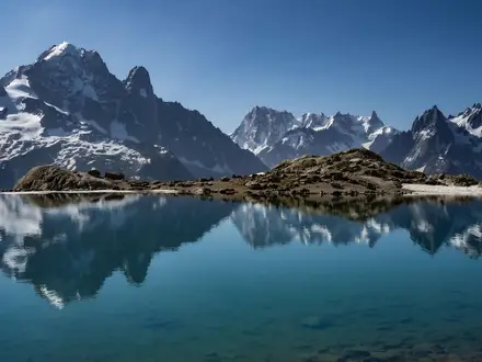
- Piz Bernina and Piz Palü: Piz Bernina, the only 4,000 m peak in the Eastern Alps, and the three-summited Piz Palü dominate the skyline. They are visible from the route but are not climbed.
- Boval Hut / Chamanna da Boval, 2,495 m: A Swiss Alpine Club refuge on the lateral moraine above the Morteratsch Glacier. It is a traditional rest and refreshment stop before descending to the valley.
- Bernina Railway finish: The walk ends at Morteratsch station on the Rhaetian Railway Bernina line, part of the UNESCO World Heritage Albula/Bernina cultural landscape. This makes the return by train straightforward.
Challenges to expect
Expect a roped glacier day, not a normal hiking trail. Crevasses, icefall terrain, snow or bare ice, rocky moraine and changing glacier conditions require a guide, crampons and surefooted movement. The route starts high at 2,973 m and descends about 1,100 m, so knees and balance matter. Weather, sun exposure on ice and the final glacier-forefield walk to Morteratsch station all add to the effort.
HikeList Score
Diavolezza Glacier Trail scored 75/100 on HikeList's trail-quality metrics.
See score breakdownHide breakdown
- Ideal length 55
- Balanced challenge 74
- Scenery & wildness 85
- Varied terrain 83
- Accommodation 66
- Food & support 81
- Path quality 98
- Season flexibility 76
Computed from length, challenge, scenery & wildness, terrain variety, accommodation, food & support, path quality and season flexibility.
 Switzerland
Show more data Show less
- Glacier
- Mountainous
- Moraine
- Ice
- Snow
- Rocky
- Huts
- Hotels
- Restrooms
- Water Sources
- Shelters
Photos from hikers
Taken on the trail by people who've reviewed Diavolezza Glacier Trail.
Reviews
How would you rate Diavolezza Glacier Trail?
Tap a star to start your review — you could be the first.