Cotswold Way
How would you rate Cotswold Way?
Tap a star to share your experience and help other hikers.
Cotswold Way: A National Trail along the Cotswold escarpment
HikeList Score
Cotswold Way scored 94/100 on HikeList's trail-quality metrics.
See score breakdownHide breakdown
- Ideal length 97
- Balanced challenge 100
- Scenery & wildness 85
- Varied terrain 83
- Accommodation 100
- Food & support 94
- Path quality 98
- Season flexibility 89
Computed from length, challenge, scenery & wildness, terrain variety, accommodation, food & support, path quality and season flexibility.
The Cotswold Way is a 164 km National Trail in south-west England, running point-to-point between Chipping Campden in Gloucestershire and Bath Abbey in Somerset. Most walkers take 7–10 days. It is a moderate walk: there is no technical terrain and the route is well waymarked, but repeated short, steep climbs on and off the Cotswold escarpment add up. It suits hikers who want a village-to-village long-distance trail with grassland, beech woods, limestone commons, historic towns and regular accommodation.
HikeList Score
Cotswold Way scored 94/100 on HikeList's trail-quality metrics.
See score breakdownHide breakdown
- Ideal length 97
- Balanced challenge 100
- Scenery & wildness 85
- Varied terrain 83
- Accommodation 100
- Food & support 94
- Path quality 98
- Season flexibility 89
Computed from length, challenge, scenery & wildness, terrain variety, accommodation, food & support, path quality and season flexibility.
Track shown from the route’s GPX file — download the GPX to load it into your own GPS app.
Route Overview
The route is usually walked north-to-south from Chipping Campden to Bath, finishing at Bath Abbey, though it can be hiked either way. It follows the western edge of the Cotswolds through Broadway, Stanton, Winchcombe, Cleeve Hill, Leckhampton Hill, Birdlip, Painswick, Wotton-under-Edge, Old Sodbury, Cold Ashton and Lansdown. Expect field paths, meadow tracks, beech woodland, limestone grassland and ridge-top common, with repeated views west over the Severn Vale. This is a point-to-point trail, so plan start and finish logistics in advance. For tougher hills, compare the Beacons Way; for a coastal alternative, see the Anglesey Coastal Path.
History of the Cotswold Way
The Cotswold Way was first proposed by the Gloucestershire branch of the Ramblers' Association in the early 1950s and designated as a recreational route by Gloucestershire County Council in 1970. It was officially opened as a National Trail on 24 May 2007. The path links rights of way along the western Cotswolds, passing landscapes shaped by the medieval wool trade as well as prehistoric and Roman sites, ruined abbeys, hillforts and historic market towns.
Notable highlights
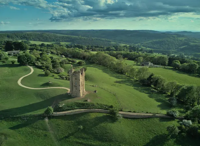
- Broadway Tower: A folly tower on the escarpment above Broadway, designed by James Wyatt and completed in 1798 for the Earl of Coventry. It is one of the high points on the route and a useful landmark early in the walk.
- Belas Knap long barrow: A well-preserved Neolithic chambered long barrow near Winchcombe, with a false entrance and several burial chambers. It adds a strong prehistoric stop to the escarpment walking.
- Hailes Abbey: The ruins of a 13th-century Cistercian abbey founded in 1246. It was once an important medieval pilgrimage site and makes a worthwhile cultural detour near Winchcombe.
- Cleeve Hill / Cleeve Common: The trail’s highest point at 330 m. This open limestone common above Cheltenham gives broad views west towards the Malverns and Wales.
- Devil’s Chimney, Leckhampton Hill: A striking limestone pinnacle left by quarrying above Cheltenham. It is one of the best-known escarpment landmarks on the route.
- Bath: The southern terminus is a UNESCO World Heritage city. The trail ends at Bath Abbey beside the Roman Baths.
Challenges to expect
The Cotswold Way is not technical, but it is not flat. The main challenge is cumulative ascent: repeated short, steep climbs and descents on the escarpment, with total ascent roughly in the 3,800–4,000 m range. Navigation is helped by National Trail acorn waymarks. Winter can mean muddy paths, shorter days, clearer views and fewer open services or accommodation options.
 United Kingdom
 England
Show more data Show less
- Grassland
- Forest
- Hills
- Dirt
- Grass
- Gravel
- Hotels
- Guesthouses
- Hostels
- Campsites
- Family Friendly
- Dog Friendly On Leash
- Restrooms
- Potable Water Sources
- Established Campsites
- Picnic Areas
- Public Transport Access Points
Download Our Full Guide to Cotswold Way FREE!
Get our comprehensive guide to this hike for free. Save it for later reading or print out at home.
In these collections
Photos from hikers
Taken on the trail by people who've reviewed Cotswold Way.
Cotswold Way: The Complete Guide
The Cotswold Way is a 164 km (102 mile) National Trail from Chipping Campden to Bath, following the western Cotswold escarpment through limestone villages, meadow paths, beech and oak woodland, open commons and broad viewpoints over the Severn Vale. It is a well-waymarked, moderate long-distance walk rather than a technical challenge, with highlights including Broadway Tower, Belas Knap, Hailes Abbey, Cleeve Common, Leckhampton Hill, Painswick, the Tyndale and Somerset monuments, and a memorable finish at Bath Abbey in the heart of the UNESCO World Heritage city.
What the route asks for is steady fitness: the high point is only 330 m, but repeated short, steep climbs add up to around 3,900–4,000 m of ascent over the full trail. This guide covers how to plan the walk in practice, including stages and itinerary choices, accommodation, food and water, transport to Chipping Campden and from Bath, terrain and conditions, baggage options, shorter sections, highlights and common planning mistakes.
Stage-by-Stage Guide
This stage guide follows the 10-day schedule used above. It combines some of the shorter official National Trail sections into practical walking days, so several stages contain more than one distinct landscape: escarpment edge, woodland, farmland and Cotswold villages. The route is generally well waymarked with National Trail acorn signs, but a map or GPX is still sensible, especially where the path crosses commons, golf-course edges and village lanes.
Stage 1: Chipping Campden to Stanton — 18 km
The Cotswold Way begins at the Market Hall in the centre of Chipping Campden, so this is the best place to make final checks before leaving town. Chipping Campden has a Coop, delis including Maylam's and Toke's, and cafés, making it one of the easiest places on the trail to buy a packed lunch and extra snacks.
The first section climbs quickly out of town to Dover's Hill, a National Trust viewpoint at 225 m overlooking the Vale of Evesham. This is an immediate introduction to the rhythm of the route: short, steep climbs onto the escarpment followed by descents into villages and farmland. The path then continues towards Broadway Tower, one of the early landmark high points, before descending into Broadway.
Broadway is a useful resupply stop rather than just a photo stop. Broadway Deli, Russell's Fish and Chips and a Coop give good food options, and the town has several B&Bs and hotels, including The Broadway Hotel and Mill Hay House. If accommodation in Stanton is unavailable, Broadway is the obvious shorter first-day finish.
Beyond Broadway the route becomes quieter, crossing field paths and escarpment ground towards Stanton. Shenberrow Camp, an Iron Age hill fort, is passed on the way. The walking is not technically difficult, but farmland sections can be muddy after rain.
Stanton is one of the most attractive overnight stops on the route, but it has very limited services. There is no shop. The Mount Inn is the main place for food and drink, with a beer garden and escarpment views. Accommodation is scarce; Shenberrow Hill B&B is often used by walkers, but rooms should be booked months ahead in the main walking season.
Road access is straightforward at Chipping Campden, Broadway and Stanton. Chipping Campden has no railway station; the usual rail approach is via Moreton-in-Marsh with the Stagecoach 1/2 bus to Chipping Campden, or via Stratford-upon-Avon. Current bus times should be checked before travelling. Navigation is generally simple on this stage, with clear National Trail waymarking through the villages and field crossings.
Stage 2: Stanton to Winchcombe — 13 km
This is a shorter and gentler day than Stage 1, passing through classic north Cotswold farmland and village country. From Stanton the trail continues via Stanway, Wood Stanway and Hailes before reaching Winchcombe.
Stanway House lies close to the route rather than directly on it. Its Jacobean gatehouse and gravity fountain are notable, but opening is limited, so it is best treated as an optional pause rather than a guaranteed visit. The path then continues through farmland and field paths, including the area around Puckpit Lane between Wood Stanway and Winchcombe.
Food is better on this stage than on some later rural sections. Hayles Fruit Farm and its Orchard Kitchen café make a useful stop roughly mid-stage for breakfasts, toasties and café food, though opening hours should be checked before relying on it. Hailes Abbey, a 13th-century Cistercian ruin founded in 1246, is a short detour close to the trail and has an entrance fee.
The Gloucestershire-Warwickshire Steam Railway runs near part of this section, adding interest without affecting the walking logistics. Underfoot, expect mostly farmland, parkland and field paths. Conditions are usually straightforward, though gateways and low-lying fields can be soft in wet weather.
Winchcombe is a strong overnight stop with proper services. The Lion Inn and Plaisterers Arms have rooms, and food options include 5 North Street, Old Bakery Coffee & Wine Bar, pubs and cafés. For resupply there is a Coop, Nisa Local and Williams deli. This is a good place to restock before the steeper climb to Cleeve Hill on the following stage.
Road access is available in the villages along the stage and in Winchcombe. Public transport options change, so onward connections should be checked before travelling. Navigation is normally uncomplicated, with regular National Trail waymarks and no notable route-finding problems.
Stage 3: Winchcombe to Cleeve Hill — 12 km
This short stage includes one of the hardest climbs of the whole Cotswold Way. It is not long, but it gains height sharply, particularly through Breakheart Plantation on the way to Cleeve Hill.
Leaving Winchcombe, the route crosses farmland and estate paths before reaching the area around Belas Knap. The Neolithic chambered long barrow is a worthwhile short, steep detour from the trail. It is an English Heritage site with open access and no entrance fee, and is one of the best prehistoric monuments on the route.
The main effort comes after Belas Knap. Breakheart Plantation gives the trail its biggest single ascent, with around 330 m of gain on the official Winchcombe to Cleeve Hill section. The woodland can be loose underfoot in places and slippery when wet, so this is a stage where poles and grippy footwear are useful.
The reward is Cleeve Common and Cleeve Hill, the highest point of the Cotswold Way and the highest point in the Cotswolds at 330 m. The common is open limestone grassland and is exposed in poor weather. In clear conditions there are extensive views west over Cheltenham, the Severn Vale and towards Wales. Prestbury Hill Nature Reserve on the approach is also known for its butterflies.
Food and water planning is important. Winchcombe is the place to buy breakfast and a packed lunch if needed. At the top end of the stage, the Cotswold Way Café at Cleeve Hill Golf Course is the key food stop, serving coffee, cake, pizza and snacks, with Flynn's on the Hill also at the Golf Club. Opening hours should be checked before relying on either.
Accommodation at Cleeve Hill is limited, and the stage ends in the common and golf-club area rather than a full village. There is B&B accommodation around the Golf Club area, but many walkers either stay another night in Winchcombe, use a pre-arranged transfer, or continue onwards. Road access is possible around Cleeve Hill, but public transport and taxis should be arranged in advance where needed.
Navigation across the common is generally well marked, but mist, wind or low cloud can make open ground feel less obvious. Keep to the signed line and avoid assuming that every trodden path on the common is the National Trail.
Stage 4: Cleeve Hill to Birdlip — 18 km
This is a long and varied escarpment day, linking Cleeve Common, Dowdeswell, Lineover Wood, Leckhampton Hill, Crickley Hill and Birdlip. It has several memorable viewpoints, but also one of the more important food and water gaps on the trail.
From Cleeve Common the route descends towards Dowdeswell Reservoir. The reservoir area is designated for its wildlife, including native white-clawed crayfish. The trail then continues through woodland and escarpment paths, including Lineover Wood, an ancient broadleaved woodland known for its old beech trees and wildflowers.
The next major landmark is Leckhampton Hill, at around 280 m, where the trail passes Iron Age hill fort remains and the Devil's Chimney, the distinctive limestone pinnacle left by quarrying. Views over Cheltenham are among the best on the northern half of the trail. Beyond this, the route continues towards Crickley Hill Country Park, with its archaeology and wide views, then Barrow Wake before reaching Birdlip.
Food and water require planning. Between Cleeve Hill and Birdlip there are no shops and no regular village facilities for much of the stage. Star Bistro near Crickley Hill operates Monday to Friday, and Crickley Hill Country Park café may provide snacks and ice cream, but neither should be treated as a guaranteed full resupply without checking current opening times. Carry enough water and food from Cleeve Hill.
Birdlip is a small hilltop village. The Royal George Hotel is the key accommodation and the main pub-food option, with rooms and meals, but there are no significant shops in the village. Booking ahead is strongly advised because alternatives are limited at the stage end.
Terrain is mixed: open common, broadleaved woodland, grass and dirt paths, gravel tracks and some road sections around settlements. The stage is not technically difficult, but it is exposed in places and long enough to punish a late start.
There is a major road-works diversion below Crickley Hill in 2026. Check the National Trails website for current diversion notices before walking this section. Road access is available at Dowdeswell, Leckhampton Hill, Crickley Hill and Birdlip, but public transport options should be checked before travelling.
Stage 5: Birdlip to Painswick — 14 km
This is one of the most satisfying mid-trail stages, with woodland, open hilltop walking and a strong finish into Painswick. It is a net descent overall, but still includes enough climbing to feel like a proper Cotswold Way day.
From Birdlip the trail heads through escarpment and woodland country. A diversion can be made to Great Witcombe Roman Villa, an English Heritage site with free access, though it is not directly on the trail. The route then passes close to Cooper's Hill, famous for the annual Bank Holiday cheese-rolling race. The path does not descend the extreme race slope, but the gradient is clear from nearby.
Buckholt Wood, a National Nature Reserve, gives good ancient beech woodland walking, especially in spring when bluebells can be strong. The route then climbs towards Painswick Beacon, an open common and golf-course area at around 280 m. The Iron Age hillfort ramparts are visible, and the views are broad in all directions. The formal midpoint marker for the Cotswold Way is near this part of the route.
The descent into Painswick is one of the finest village approaches on the trail. St Mary's Church, with its clipped yew trees and ornate table tombs, sits at the heart of the town. Painswick Rococo Garden is an optional visit with an entrance fee and seasonal opening.
Food options are much better at the end than during the middle of the stage. Painswick has the Falcon Inn, The Oak, St Michael's Bistro and Arts Café, plus a Premier Express for basic shopping. Accommodation includes the Falcon Inn opposite the church, The Painswick hotel and St Anne's B&B. This is a good place for an unhurried overnight stop.
Underfoot, expect woodland tracks, open common, a golf-course crossing on the signed path, and village streets. Navigation is usually straightforward, but stay on the marked line across golf-course and common land. Road access is available at Birdlip and Painswick; intermediate public transport should be checked before travelling.
Stage 6: Painswick to King's Stanley — 15 km
This stage crosses the central part of the route and includes strong woodland walking and wide Severn Vale views. It is moderate rather than severe, with around 315 m of ascent and 330 m of descent on the official Painswick to King's Stanley section.
The route leaves Painswick and moves through woodland and open ground towards Standish Wood, an extensive beech forest and National Nature Reserve. In spring, bluebells and wood anemones can be a highlight. The path then reaches Haresfield Beacon and Ring Hill, where Iron Age hillfort earthworks and broad views across the Severn Vale towards the Forest of Dean and Wales make this one of the better mid-trail viewpoints.
The halfway point of the Cotswold Way falls just south of Painswick, soon after leaving the town, marked by a stone showing 55 miles to Bath; the route then continues over Standish Wood and Haresfield Beacon towards the Stroudwater Navigation. At the canal there are two clear route options, one briefly following the towpath. Woodchester Valley Vineyard lies close to the route and is visible from nearby, though it is not on the trail itself.
There is no on-trail café between Painswick and King's Stanley, so carry food from Painswick unless planning a short diversion. The Vine Tree Inn in Randwick and the Carpenters Arms in Westrip are both roughly 300–500 m off the trail and can work for lunch, subject to opening times.
King's Stanley is a village rather than a town, but it has a Coop supermarket that is useful for resupply. Evening meal options in the village are limited, so walkers often need to plan ahead, use local takeaway options, or travel to nearby Stonehouse or Stroud by taxi. Accommodation includes Orchardene and The Grey Cottage B&Bs.
Terrain is varied but manageable: beech woodland, grassland, field paths and a short canal-side section. Mud is possible in woodland and field sections after rain. Road access is available around Painswick, Haresfield, the canal area and King's Stanley. Public transport and taxi arrangements should be checked before travelling.
Stage 7: King's Stanley to Wotton-under-Edge — 23 km
This is the longest stage in the 10-day itinerary and should be treated as a full day. Allow 7–8 hours of walking time, plus stops. It is also one of the richest stages for prehistoric sites, hilltop views and landmarks, but the distance and repeated climbs make pacing important.
From King's Stanley the route heads towards Nympsfield Long Barrow, a chambered tomb dating from around 2800 BC. Coaley Peak follows as a useful rest point, with picnic facilities and wide views over the Severn Vale. The trail then continues towards Uley and Hetty Pegler's Tump, also known as Uley Long Barrow, where access to the burial chamber requires a low crouch.
Cam Long Down is one of the distinctive hills of the stage, with strong 360-degree views from the plateau. The route then drops towards Dursley, an important practical stop roughly halfway through the day. Dursley has multiple supermarkets, café options and the Old Spot pub, making it the best place to refuel before the afternoon section.
Beyond Dursley, the trail skirts Stinchcombe Hill around the golf-course perimeter. A shortcut across the neck of the hill saves about 4.5 km, but the full route gives the better views. From North Nibley, where there is a shop and the Black Horse Inn, the trail climbs steeply again to the Tyndale Monument.
The Tyndale Monument is one of the major landmarks of the southern half of the route. The 111-foot stone tower was built in 1866 to commemorate William Tyndale. The spiral staircase has 121 steps, with access by key from a nearby cottage and a small fee. The views from the ridge are excellent in clear weather.
The final approach to Wotton-under-Edge passes Waterloo Copse, a walled tree enclosure planted in 1815 to mark the Battle of Waterloo. Wotton-under-Edge is a proper market town and a strong overnight stop, with Coop, Tesco, Relish deli, a bakery, cafés and pubs. The Swan Hotel, a 17th-century coaching inn, is the main accommodation, with The Cabin self-catering and various B&Bs also available.
Terrain is highly varied: woodland, grassland, hilltop plateau, village lanes and steep climbs and descents, especially around North Nibley. Start early, carry enough water from King's Stanley, and use Dursley as the main resupply point. Road access is available at Dursley, North Nibley and Wotton-under-Edge. Navigation is generally well signed, but take care around golf-course edges and where multiple paths cross Stinchcombe Hill.
Stage 8: Wotton-under-Edge to Old Sodbury — 20 km
This is a quieter southern stage, with less of the dramatic escarpment feel found earlier but plenty of parkland, woodland, drovers' roads and village walking. It is a rewarding day if treated as a rural crossing rather than a landmark-to-landmark ridge walk.
Leaving Wotton-under-Edge, the trail heads towards Newark Park, a National Trust property set in a strong hillside position above a deep valley. The café is seasonal, and entrance fees apply to the property, so check opening times before relying on it for food. The route then continues through Alderley and Lower Kilcott, where the valley setting becomes more enclosed.
The Somerset Monument near Hawkesbury Upton is the main hilltop feature of the day, a 100-foot tower commemorating General Lord Robert Somerset. Hawkesbury Upton itself is the best practical mid-stage stop, with the Fox Inn, Beaufort Arms and Hawkesbury Stores.
Further south, the trail passes close to Horton Court, a National Trust property with 16th-century buildings and a filming connection with the BBC series Wolf Hall. Near Old Sodbury the route passes Sodbury Camp, an Iron Age hillfort with clear earthworks, before descending to the village.
Old Sodbury is a village, not a town. The Dog Inn is the key accommodation and main food option, with a small number of en-suite rooms. Sodbury House is a farmhouse B&B nearby. Services are limited, so evening food and breakfast arrangements should be made when booking accommodation.
Terrain includes parkland, drovers' tracks, woodland and open field paths. The drovers' roads can be deeply rutted and muddy in wet seasons, making this stage slower than the distance alone suggests. Road access is available at Wotton-under-Edge, Hawkesbury Upton and Old Sodbury. Public transport options should be checked before travelling.
Stage 9: Old Sodbury to Cold Ashton — 14 km
This is a quieter transitional stage through rolling farmland, estate edges, woodland and parkland. It is shorter than the previous two stages, but the logistics at the end require attention because Cold Ashton has no food or general services.
From Old Sodbury the trail heads towards Tormarton, a small village where the Compass Inn is a useful pub and restaurant a short diversion of around 300 m off route. This is the main realistic food stop on the stage unless using seasonal National Trust facilities later in the day.
The route skirts the perimeter of Dodington Park, an 18th-century landscaped estate designed by Capability Brown. The parkland is visible from the boundary rather than being a through-route. Further on, Dyrham Park gives one of the key features of the stage: a 17th-century baroque mansion, formal gardens, deer park and expansive parkland. The National Trust café is seasonal, and entrance fees apply to the mansion and gardens.
Dyrham Wood adds ancient woodland walking, with bluebells in spring and a walkers' postbox where notes are traditionally left. The stage also includes a motorway crossing around the A46/M4 interchange, where the trail follows the A46 road overbridge across the M4 alongside slip-road traffic rather than a dedicated footbridge; it is functional rather than scenic.
Cold Ashton is a tiny hamlet on the escarpment edge. There are no shops, pubs or food services. Walkers ending here must arrive with enough food and water for the evening unless accommodation provides meals. Nearby accommodation is limited to small B&Bs such as Hill Farm, on or very close to the route, and Toghill House Farm, around 1 mile off route. Both should be booked well ahead.
Terrain is rolling farmland, parkland, ancient woodland and some road sections. It is generally straightforward underfoot, but field paths and woodland can be muddy after rain. Road access exists at Old Sodbury, Tormarton, Dyrham and Cold Ashton, but onward public transport should be checked before travelling.
Stage 10: Cold Ashton to Bath — 17 km
The final stage is a high-to-low finish, with open escarpment walking, Civil War history, a broad approach to Bath and then an urban finish at Bath Abbey. There is around 225 m of ascent and 400 m of descent on the official Cold Ashton to Bath section, so the day is not simply downhill.
Start self-sufficient from Cold Ashton, as there are no services in the hamlet. The route climbs onto Lansdown Hill, at around 275 m, the site of the Battle of Lansdown in 1643. Sir Bevil Grenville's Monument marks the death of the Royalist commander and is a useful point to pause before the final ridge section.
The trail then follows open ground around Hanging Hill and Bath Racecourse. This section is exposed and can be breezy, but navigation is generally straightforward in clear conditions. Prospect Stile is the classic viewpoint as the route turns towards Bath, with views to Bath, the Avon Valley and, in clear weather, much wider country to the west.
Kelston Round Hill marks the final prominent escarpment high point before the descent towards the city. The walking along the ridge between the racecourse and Kelston Round Hill is open and direct, before the route begins to enter the suburban edge of Bath.
Weston is the first proper service point after Cold Ashton. Tesco Express, Parsons Bakery and Café 25 make it a useful place for food, drink and a final break before the urban approach. From there the trail continues through streets, parks and the Georgian cityscape, with the Royal Crescent, The Circus and central Bath forming the visual lead-in to the finish.
The Cotswold Way ends at the carved stone disc set into the pavement outside the west doors of Bath Abbey. Bath Spa railway station is about 500 m from the Abbey and is easily reached on foot, making onward travel much simpler than at the start of the route.
Underfoot, expect hilltop grassland, racecourse perimeter paths, open ridge walking, suburban streets, parks and pavements. A temporary diversion may affect the section between Weston Park East and Summerhill Road from January 2026 onwards. Check the National Trails website for current diversion notices before walking this stage.
Recommended Itinerary
The Cotswold Way is most easily planned around village and small-town overnight stops rather than equal daily mileage. Accommodation pinch points matter as much as distance: Stanton, Cleeve Hill, King's Stanley, Old Sodbury and Cold Ashton all need early booking, and some have very limited food or shop options.
Standard itinerary: 8 days
This is a practical standard schedule for fit walkers who are comfortable with a few longer days and want to keep the walk to just over a week. It uses the same route sections as the 10-day plan but combines Birdlip–Painswick–King's Stanley into one longer stage.
| Day | From | To | Approx. distance | Why this stage makes sense | Services/accommodation notes |
|---|---|---|---|---|---|
| 1 | Chipping Campden | Stanton | ~18 km | A strong first day from the traditional start at the Market Hall, with Broadway roughly midway as a useful break point. | Chipping Campden has B&Bs, inns, pubs, restaurants and a Co-op opposite the Market Hall for supplies. Broadway has excellent cafés, pubs and shops. Stanton is very small: book well ahead and do not rely on arriving Sunday, Monday or Tuesday without a plan B. |
| 2 | Stanton | Cleeve Hill / Cleeve Common | ~25 km | Combines the shorter Stanton–Winchcombe and Winchcombe–Cleeve Hill stages, with Winchcombe working well as the main lunch and resupply stop. | Winchcombe is one of the best-serviced places on the northern half, with shops, cafés, pubs and accommodation. Cleeve Hill has very limited services beyond The Rising Sun Hotel; stock up before leaving Winchcombe. |
| 3 | Cleeve Hill / Cleeve Common | Birdlip | ~18 km | A high escarpment day from the trail's highest ground, with repeated climbs and descents rather than difficult terrain. | Cleeve Common is exposed in poor weather. Birdlip has limited services; The Royal George Hotel is the key accommodation and food option. |
| 4 | Birdlip | King's Stanley | ~29 km | A longer linking day that passes through Painswick and avoids adding a separate overnight there. It suits walkers aiming for an 8-day finish, but it is one of the harder days on this schedule. | Painswick is the important mid-stage service stop, with cafés, pubs, shops and good accommodation if the day needs shortening. King's Stanley has limited accommodation; Stonehouse, about 1 mile off-route, is a common alternative. |
| 5 | King's Stanley | Wotton-under-Edge | ~23 km | The longest standard-stage day after Birdlip–King's Stanley, with the southern escarpment beginning to feel more spaced out between strong service points. | King's Stanley has limited accommodation but a Co-op for resupply. Wotton-under-Edge is a much better-serviced market town with supermarkets, pubs, cafés, restaurants and accommodation including The Swan Hotel. |
| 6 | Wotton-under-Edge | Old Sodbury | ~20 km | A manageable but still full day through the quieter southern Cotswolds, passing the Hawkesbury Upton area before Old Sodbury. | Wotton-under-Edge is the best place to resupply before this section. Old Sodbury has very limited accommodation, with The Dog Inn and Sodbury House among the main options; book early. Accommodation can be especially scarce around the Badminton Horse Trials in early May. |
| 7 | Old Sodbury | Cold Ashton | ~14 km | A deliberately shorter day after several longer stages, leaving a sensible final approach into Bath. | Old Sodbury has limited services. Cold Ashton has minimal services, no reliable village shop or central pub meal option; carry dinner/snacks or arrange food with accommodation in advance. |
| 8 | Cold Ashton | Bath | ~17 km | A compact final stage into Bath, finishing at Bath Abbey in the city centre. | Bath has the widest accommodation choice on the route, from hostels to high-end hotels. Bath Spa station is a short walk from Bath Abbey. |
Slower itinerary: 10 days
This is the best version for most first-time long-distance walkers, anyone carrying a full pack, and anyone who wants time for places such as Hailes Abbey, Belas Knap, Painswick and the Bath finish. Most days stay below 20 km; the main exception is King's Stanley to Wotton-under-Edge.
| Day | From | To | Approx. distance | Why this stage makes sense | Services/accommodation notes |
|---|---|---|---|---|---|
| 1 | Chipping Campden | Stanton | ~18 km | A satisfying opening stage with Broadway as a natural mid-stage stop before continuing to a quiet overnight village. | Chipping Campden is a good arrival-night base with shops, pubs, restaurants and accommodation. Broadway has strong services. Stanton has very limited beds and food options; book months ahead where possible, and avoid Sunday/Monday/Tuesday arrivals unless arrangements are clear. |
| 2 | Stanton | Winchcombe | ~13 km | A shorter day that gives time for the northern villages and makes Winchcombe a comfortable overnight rather than just a lunch stop. | Winchcombe is one of the most useful service stops on the route, with a Co-op, Nisa, cafés, pubs, restaurants and several inns. It is also a good base for Sudeley Castle and Hailes Abbey side visits. |
| 3 | Winchcombe | Cleeve Hill / Cleeve Common | ~12 km | Short in distance but useful for managing the climb onto the highest part of the trail without rushing. | Stock up in Winchcombe before leaving. Cleeve Hill accommodation and food options are limited, with The Rising Sun Hotel the main overnight stop. The open common can feel exposed in poor weather. |
| 4 | Cleeve Hill / Cleeve Common | Birdlip | ~18 km | A proper escarpment day with broad views, upland common and woodland sections, ending at a practical road-village stop. | Birdlip has limited services; The Royal George Hotel is the main accommodation and meal option. Carry enough water and snacks from Cleeve Hill. |
| 5 | Birdlip | Painswick | ~14 km | A shorter stage that keeps the itinerary relaxed and gives time to enjoy Painswick rather than passing straight through. | Painswick is one of the best overnight stops on the southern half, with hotels, B&Bs, pubs, cafés and restaurants. It is a sensible place to book a more comfortable night. |
| 6 | Painswick | King's Stanley | ~15 km | A moderate day that breaks up what would otherwise become a very long push towards Wotton-under-Edge. | King's Stanley has limited accommodation and food options; book early. Stonehouse, about 1 mile off-route, is often used as an alternative because it has more accommodation. Use the Co-op in King's Stanley for resupply. |
| 7 | King's Stanley | Wotton-under-Edge | ~23 km | The longest day on the 10-day schedule and the main endurance test of the slower itinerary. | Start with food and water arranged. Wotton-under-Edge is a welcome full-service stop, with supermarkets, pubs, cafés, restaurants and accommodation. |
| 8 | Wotton-under-Edge | Old Sodbury | ~20 km | A full but manageable day through quieter country, with Wotton providing the best morning resupply. | Old Sodbury has very limited accommodation and services. Book early, especially around early May when the Badminton Horse Trials place pressure on rooms in this area. |
| 9 | Old Sodbury | Cold Ashton | ~14 km | A short penultimate stage that avoids making the final approach to Bath too long. | Cold Ashton has minimal services. Do not assume an evening meal or shop will be available; carry food from Old Sodbury or Wotton-under-Edge, or arrange food with accommodation. |
| 10 | Cold Ashton | Bath | ~17 km | A final manageable stage into Bath, with the trail ending at Bath Abbey. | Bath has extensive accommodation, food and transport options. Bath Spa station is a short walk from the finish. |
Faster variant: 6–7 days
A 6–7 day Cotswold Way is for very fit walkers who are happy with long days, repeated short climbs and less time in villages. It works best with baggage transfer and pre-booked accommodation, because the strongest overnight stops do not always fall at ideal mileage intervals.
A compact 6-day shape can be built by combining the 10-day stages below, but distances should be checked against official mapping before booking, especially if using off-route accommodation.
| Day | From | To | Approx. distance | Why this stage makes sense | Services/accommodation notes |
|---|---|---|---|---|---|
| 1 | Chipping Campden | Winchcombe | ~31 km | Skips the Stanton overnight and uses Winchcombe as the first strong service stop. | Broadway and Stanton break up the day, but Stanton is not a dependable late-booking stop. Winchcombe has good shops, pubs, cafés and accommodation. |
| 2 | Winchcombe | Birdlip | ~30 km | Links the high Cleeve Hill section with the onward escarpment to Birdlip. | Resupply well in Winchcombe. Cleeve Hill and Birdlip have limited services; Birdlip's key overnight option is The Royal George Hotel. |
| 3 | Birdlip | King's Stanley | ~29 km | Passes through Painswick while keeping the southern half moving. | Painswick is the best mid-stage service point. King's Stanley has limited accommodation; Stonehouse is a practical off-route alternative. |
| 4 | King's Stanley | Wotton-under-Edge | ~23 km | A hard but more conventional long-distance walking day compared with the 30 km stages either side. | Wotton-under-Edge is a strong resupply and overnight stop before the quieter southern sections. |
| 5 | Wotton-under-Edge | Cold Ashton | ~34 km | A very long day that combines the Old Sodbury stage and should only be used by walkers confident at sustained mileage. | Old Sodbury is the natural place to split this day if turning the plan into 7 days. Accommodation around Old Sodbury and Cold Ashton is limited and can be scarce in early May. |
| 6 | Cold Ashton | Bath | ~17 km | A shorter final day into the Bath Abbey finish. | Carry food from the previous stop if staying in Cold Ashton. Bath has extensive accommodation and onward rail connections from Bath Spa. |
For a 7-day version, the simplest adjustment is to split Wotton-under-Edge to Cold Ashton at Old Sodbury, creating a more manageable final two days. That still leaves several demanding days, so accommodation availability should drive the final booking pattern rather than mileage alone.
Planning the Route
How many days to allow
For most independent walkers, 9–10 days is the best planning window for the Cotswold Way. It keeps daily distances manageable, leaves time for the repeated escarpment climbs, and gives room to visit places such as Hailes Abbey, Belas Knap, Painswick and Bath without turning the route into a daily race for the next bed.
A 7–8 day itinerary is perfectly possible for fit walkers, but it makes the walk feel more workmanlike. Expect longer days, less time in Chipping Campden, Winchcombe, Painswick and Bath, and a higher chance that accommodation availability rather than preferred pace dictates the schedule.
| Schedule | Best for | Planning notes |
|---|---|---|
| 5–6 days | Very fit, experienced walkers | Long days of roughly 18–20 miles. Little time for villages, abbey ruins or viewpoints. Accommodation logistics become tighter. |
| 7–8 days | Confident walkers who want to cover ground | Achievable, but the repeated short climbs and descents off the escarpment add up. Book carefully at constrained overnight stops. |
| 9–10 days | Most walkers, first long-distance trips, relaxed village-to-village walking | The most practical balance of distance, recovery time and sightseeing. Many self-guided itineraries sit around this pace. |
| 12–13 days | Very leisurely walkers or those adding rest days | Useful if combining short stages with time in towns, but not necessary for most hikers. |
The Cotswold Way rewards taking slightly longer than the bare minimum. The trail is not technically difficult, but around 3,900–4,000 m of total ascent is accumulated through repeated climbs rather than one major mountain day. A schedule that looks moderate on paper can feel harder by days four, five and six if every day is walked at a fast pace.
Fast or slow: what suits this trail?
This is a route where a slower plan often works better than a fast one. The interest is spread through historic wool towns, small villages, woodland, open limestone common, hilltop monuments and escarpment viewpoints. Rushing the Cotswold Way tends to remove much of what makes it worth walking.
A fast itinerary makes most sense if the goal is simply to complete the National Trail, if accommodation has already been secured in the right places, and if the walker is comfortable with consecutive hilly days. A slower itinerary is better for a first long-distance walk, for anyone using B&Bs and pubs rather than camping, and for walkers who want time to stop at Broadway Tower, Hailes Abbey, Belas Knap, the Tyndale Monument or Bath at the finish.
Accommodation will shape the itinerary
Accommodation is the main planning constraint on the Cotswold Way. The trail passes through many attractive villages, but several have very limited overnight capacity. In practice, daily stages are often dictated less by ideal mileage and more by where a bed is available.
Key pinch points include:
- Stanton — accommodation directly on the route is extremely limited. Shenberrow Hill B&B is the main on-route option and does not usually permit single-night stays, so many walkers continue to Broadway or book far ahead. Policies should be checked before booking.
- Winchcombe — one of the larger settlements on the northern part of the route, but rooms still fill quickly relative to demand.
- Birdlip — accommodation on the route is very limited, with the Royal George Hotel being the principal on-route option. If it is full, the itinerary may need to be adjusted.
- Painswick — popular and limited. Booking several months ahead is sensible in the main walking season.
- Wotton-under-Edge — a useful overnight town with more choice than the smallest villages, but still not a large accommodation hub.
- Bath — much easier for accommodation, but prices and availability vary sharply around weekends and events.
In peak season, especially Easter, bank holiday weekends and the July–August school holidays, book accommodation at least 3–4 months ahead where possible. In the shoulder season, 4–6 weeks ahead is still sensible. Some properties impose two-night minimum stays at weekends, including some inns, B&Bs and glamping options, so do not assume that a single-night booking will always be possible.
Wild camping is not a fall-back plan here. There is no general right to pitch freely in England, and the Cotswold Way should be planned around booked accommodation, official campsites where available, or pre-arranged overnight stops.
Food, water and resupply
Food planning is straightforward in the larger towns, but not reliable on every stage. Most B&Bs and guesthouses provide breakfast, yet lunch is the part that catches walkers out: pubs and cafés are not always directly on the trail, opening hours vary, and some villages have little or no shop provision.
Carry lunch or emergency food on quieter stages, especially where the day runs through smaller villages or more rural sections around Stanton, Birdlip, King’s Stanley, Old Sodbury and Cold Ashton. Village shops can close early, and pub opening patterns can change outside summer or away from weekends. Evening meals should also be planned when staying in smaller places; if there is only one pub or inn nearby, book a table or check serving times before arrival.
Water is usually manageable if staying in accommodation each night, but do not rely on frequent public taps or shops. Start each day with enough water for the full stage, particularly in warm weather on open sections such as Cleeve Common and Lansdown.
Transport planning: start, finish and bail-out points
Transport is easy at the Bath end and more awkward at the northern start. Chipping Campden has no railway station. The usual rail approach is to Moreton-in-Marsh, then the Stagecoach 1 or 2 bus to Chipping Campden, taking about 40 minutes. Stratford-upon-Avon is another rail option. Bus times, Sunday services and seasonal changes should be checked before travelling.
At the finish, Bath Spa station is a short walk from Bath Abbey, making onward travel much simpler.
Useful access points for section walkers and itinerary changes include:
| Place | Use for planning | Notes |
|---|---|---|
| Chipping Campden | Northern start / section start | Bus from Moreton-in-Marsh or Stratford-upon-Avon; check Stagecoach 1/2 times before travelling. |
| Winchcombe | Northern section break | Bus links with Cheltenham; useful for splitting the early stages. |
| Painswick | Mid-route access | Bus to Stroud, then rail connections from Stroud. |
| King’s Stanley / Middleyard | Mid-route break | Bus access towards Stroud from the Ebley Road area. |
| Cam & Dursley station | Southern-mid section access | Around 2.5 km from the trail near Dursley, on the Birmingham–Bristol line. |
| Old Sodbury | Southern section break | Bus access from Bristol is possible but infrequent; this should be checked before travelling. |
| Bath Spa | Finish / southern access | Main-line rail connections and a short walk from the finish at Bath Abbey. |
Public transport across the Cotswolds is patchy, and buses can be sparse outside Monday–Saturday daytime patterns. For section hiking, build the day around the bus or train timetable rather than assuming a service will be available when the walk ends.
Section hiking the Cotswold Way
The Cotswold Way works well as a section hike, particularly on the northern and central parts where places such as Chipping Campden, Winchcombe, Painswick, King’s Stanley, Cam & Dursley and Bath give realistic access points. The official National Trail material divides the route into 15 sections, which is useful when building day walks or weekend blocks.
The main limitation is not the walking, but the transport. Some sections are easy to arrange with rail and bus links via Moreton-in-Marsh, Cheltenham, Stroud, Cam & Dursley or Bath. Others require early starts, careful bus timing, taxis or overnight stays. Sunday services are especially limited in many Cotswold villages, so weekend section plans need checking closely.
Shortening, extending and rest days
The route is flexible if accommodation and transport are planned early. It is usually easier to shorten the walk than to extend it: several towns and access points allow exit towards Cheltenham, Stroud, Bristol or Bath if weather, fatigue or time becomes an issue.
There are no essential side routes required to complete the trail. Optional extra time is better spent slowing the main itinerary rather than adding distance. Natural rest or half-day stops include:
- Broadway — useful if the first day is kept short or if continuing beyond Stanton.
- Winchcombe — well placed for Hailes Abbey and Belas Knap.
- Painswick — a good mid-route pause if accommodation is available.
- Bath — the obvious place to add time at the finish.
A detour into Cheltenham is possible from the Cleeve Hill / Leckhampton Hill area, but it is off-route and should be treated as a transport or rest-day choice rather than part of the core trail plan.
Navigation, mapping and diversions
The Cotswold Way is well waymarked with National Trail acorn symbols, and navigation is generally straightforward. That said, do not rely only on signposts. Summer vegetation can obscure waymarks, woodland paths can be confusing, and tired walkers often make mistakes at field edges, lanes and estate tracks.
Carry or download a proper route line and use mapping that covers the full trail. The relevant Ordnance Survey Explorer maps are OL45 The Cotswolds and OL41 for the southern section around Stroud and Dursley. A dedicated Cicerone National Trail guide is also available. Mobile signal can be patchy in wooded sections, so offline maps are strongly recommended.
Check the official National Trail website before walking and again during the trip for live route changes. Current planning should account for diversions near Birdlip, a permanent diversion at North Nibley, and an ongoing diversion at Tormarton. Diversions can affect timings and meeting points, especially if using baggage transfer or public transport.
Weather, exposure and seasonal practicalities
There is no technical mountain terrain, but the route is exposed in places. Cleeve Hill / Cleeve Common and Lansdown can feel very open in wind, rain or summer heat. Mud is common in winter and spring on field paths and woodland sections, while hard, dry tracks and open grassland can feel surprisingly hot in summer.
Spring, summer and autumn are the main walking seasons. In warm weather, carry more water than the map suggests and do not assume every village has an open shop. In wet periods, expect slow going on grassy slopes, woodland paths and field crossings.
Permits, fees and baggage transfer
No permit is required to walk the Cotswold Way, and there is no fee for the trail itself. It follows public rights of way and access land along the western Cotswold escarpment. Individual attractions may charge admission: Hailes Abbey is managed by English Heritage and an entry fee applies for visiting the ruins, although the trail passes the exterior without charge.
Baggage transfer is available on the Cotswold Way, including services such as Carryabag between Chipping Campden and Bath. If using luggage transfer, book it alongside accommodation rather than as an afterthought, and check current collection rules, bag limits and excluded stops before committing to an itinerary.
Towns, Villages and Overnight Stops
Accommodation availability has a real effect on Cotswold Way itineraries. The route passes several well-served market towns, but some of the most useful overnight points are small villages with only one or two realistic places to stay. Book Stanton, Birdlip and Cold Ashton particularly early, especially for spring, summer and weekend dates.
| Planning issue | Practical implication |
|---|---|
| Scarce overnight stops | Stanton, Birdlip and Cold Ashton have very limited accommodation, so these stops often determine the whole schedule. |
| Best resupply points | Chipping Campden, Winchcombe, Painswick, King's Stanley, Wotton-under-Edge and Bath. Chipping Sodbury is useful via a short detour from Old Sodbury. |
| Cash | Use ATMs in larger stops such as Chipping Campden, Winchcombe, Painswick or Wotton-under-Edge; many smaller villages have no ATM. |
| Sunday trading | Small-town shops, especially in places such as Wotton-under-Edge, may close or run reduced hours on Sundays. Stock up beforehand. |
| Empty stretches | Carry food and water between King's Stanley and Dursley, and between Hawkesbury Upton and Old Sodbury. |
| Mid-route exits | Stroud is the most useful mainline rail option around the middle of the route, accessible from Painswick or King's Stanley by bus or taxi. Cheltenham is accessible from the Cleeve Hill/Dowdeswell area. |
Chipping Campden
Chipping Campden is the northern start of the Cotswold Way, with the traditional start marker at the Market Hall in the town centre. It is the right place to arrive the day before starting, rather than trying to reach the trailhead early and walk immediately.
The town has strong walker services: Co-op and One Stop supermarkets on the High Street, delis including Maylam's and Toke's, cafes, pubs and restaurants. There are public toilets on Sheep Street and High Street, and an ATM in town. Withdraw cash here, as the next smaller villages are much less reliable for banking services.
Accommodation ranges from B&Bs and inns to higher-end hotels, including Cotswold House Hotel and the Eight Bells Inn. Chipping Campden is very popular in spring and summer, so the night before the walk should be booked well ahead.
There is no railway station in Chipping Campden. The usual rail approach is via Moreton-in-Marsh, with the Stagecoach 1/2 bus taking about 40 minutes to Chipping Campden. Stratford-upon-Avon is another rail option with a bus connection. Current bus times should be checked before travelling.
Broadway
Broadway is reached early on the first day, around 5–6 miles from Chipping Campden. It is a large, popular Cotswolds village with far more services than the smaller places that follow.
For food and supplies, Broadway has boutique shops, delis, cafes, restaurants and pubs. Broadway Deli and Russell's Fish and Chips are useful food stops, while the Lygon Arms is the best-known historic coaching inn. The Crown and Trumpet is a more budget-friendly pub accommodation option. Public toilets are at the Activity Park and Church Close Car Park.
Broadway works well as a short first-day overnight if accommodation in Stanton is unavailable or if a slower itinerary is preferred. It is, however, one of the pricier accommodation stops on the route.
Bus options include Pulhams 606 towards Winchcombe and Cheltenham, Rural 4 from Evesham, and the Thursday-only 608 towards Cheltenham via Chipping Campden. These services do not all run daily, so timetables must be checked before relying on them.
Broadway Tower
Broadway Tower is a major early landmark on the escarpment above Broadway, rather than an overnight base. Treat it as a route highlight and viewpoint, not as a resupply stop. The practical overnight choices for this part of the route are Chipping Campden, Broadway or Stanton.
Stanton
Stanton is a classic first-night stop on a 10-day schedule, about 18 km from Chipping Campden. It is one of the most attractive stone villages on the route, but its appeal comes with a planning problem: there are very few services.
Accommodation is extremely limited. Shenberrow Hill B&B is the main walker option and should be booked many months ahead for busy periods. The Mount Inn sits above the village and is the main pub option, but it is more restaurant-style and typically opens in the evening, so early meals and casual resupply should not be assumed.
There is no shop in Stanton. Carry what is needed from Broadway, or plan to resupply properly in Winchcombe the next day. There is no reliable public transport from Stanton, so a taxi is normally required if bailing out or repositioning to Broadway or Winchcombe.
Stanway / Wood Stanway
Stanway and Wood Stanway are tiny hamlets between Stanton and Winchcombe. They are attractive places to pass through but not dependable service stops.
There are no shops and no pubs in the hamlets. Stanway House and its water fountain/gardens may open seasonally, but this should not be used as part of a food or water plan. A couple of farm accommodation options exist in the area, including a farmhouse option near Wood Stanway with a pub roughly a mile away, but availability is limited and should be arranged in advance.
Carry food and water through this stretch.
Hailes / Hailes Abbey
Hailes sits close to Winchcombe and is best known for Hailes Abbey, the 13th-century Cistercian ruin near the trail. It is more useful to campers than to B&B walkers.
Hayles Fruit Farm campsite is one of the stronger camping stops on the route, with basic but clean facilities, portacabin toilets, showers, drinking water and fire pits. The on-site farm shop cafe usually closes around 5pm, so late-arriving walkers should not rely on it for dinner. Camping is typically around £8–10 per person, but current prices should be checked before booking.
Away from the abbey, church and campsite, services are very limited. Winchcombe is the main service base for this section.
Winchcombe
Winchcombe is one of the most important service towns on the Cotswold Way and a natural overnight after Stanton. It sits about 31 km from Chipping Campden on the 10-day schedule.
The town has useful resupply, including Co-op, Nisa Local and independent cafes such as Old Bakery Coffee & Wine Bar. Pub and inn options include the Lion Inn, the Plaisterers Arms and the White Hart Inn, which has rambler rooms. The Lion Inn and White Hart Inn are key walker accommodation options, supported by several B&Bs in and around town. Quality and availability vary, so book ahead rather than arriving speculatively.
Public toilets are at Back Lane car park, with a 20p charge. For a more expensive meal, 5 North Street is an upmarket restaurant and should be booked ahead.
Winchcombe is also the base for nearby route highlights: Belas Knap long barrow lies above town on the route, and Sudeley Castle is a short detour. Pulhams 606 provides a limited bus link towards Broadway and Cheltenham; check current timetables before planning around it.
Stock up here before the higher, more exposed Cleeve Hill section.
Belas Knap
Belas Knap is a route highlight rather than a place to stay. The Neolithic long barrow lies above Winchcombe and is best visited as part of the walking day between Winchcombe and Cleeve Hill/Cleeve Common. There are no walker services at the monument itself, so use Winchcombe for accommodation, meals and resupply.
Cleeve Hill / Cleeve Common
Cleeve Hill and Cleeve Common form the highest part of the Cotswold Way at 330 m. This is open limestone common above Cheltenham, with wide views west, but services are thin and exposed-weather planning matters more here than in the villages.
There are no shops on the common. Carry enough food and water from Winchcombe, and do not assume a casual resupply opportunity on the ridge. The golf club cafe, known as Cotswold Way Cafe / Flynn's at the Golf Course, is a useful refreshment stop when open.
Accommodation is limited around the ridge. Cleeve Hill Hotel, on the B4632 slightly off the ridge, has 13 rooms and offers breakfast and packed lunches. Some walkers instead stay off-route in Cheltenham, which has far more accommodation and services, then use a taxi or bus to return to the trail.
Stagecoach W connects the Cleeve Hill area towards Cheltenham. Services and stopping points should be checked before travelling.
Dowdeswell
Dowdeswell is useful mainly as an off-ridge accommodation and transport option for walkers planning the Cleeve Hill section. Charlton Boutique Hotel in Dowdeswell is around 0.6 miles off the route and is one of the main places to stay in this area.
Pulhams 801 from Dowdeswell runs towards Cheltenham, making it useful for accessing town services or returning to the trail after an off-route night. Current timetables should be checked before relying on this connection.
Leckhampton Hill / Devil's Chimney
Leckhampton Hill is a strong landmark section above Cheltenham, with the Devil's Chimney limestone pinnacle one of the best-known features on the Cotswold escarpment. It is not a village stop and should not be planned as a resupply point.
For accommodation and services around this part of the route, look to Cleeve Hill, Dowdeswell, Birdlip or off-route Cheltenham, depending on the itinerary.
Birdlip
Birdlip is a small escarpment village and a useful overnight after the long ridge section from Cleeve Hill. Its value is practical rather than scenic: it breaks the route at a sensible point, but facilities are very limited.
The Royal George Hotel is the only accommodation in the village, with 34 rooms, pub food and a walker-friendly setup. There is no shop in Birdlip, and the Royal George is also the only food option in the village itself. Book ahead, and carry backup snacks in case arrival is late or meal times do not suit.
Cooper's Hill
Cooper's Hill lies between Birdlip and Painswick on the route corridor. It is not a practical overnight or resupply stop for most walkers. Plan this section around Birdlip and Painswick, and carry what is needed for the day.
Painswick
Painswick is one of the best mid-route bases on the Cotswold Way, roughly halfway along the trail at about 74 km from Chipping Campden. It is a historic wool town with enough services to rest, resupply and reset gear.
Food options include Premier Express for groceries, cafes such as Arts Cafe and St Michael's Bistro, and pubs including the Falcon Inn and The Oak. Public toilets are at Stamages Lane car park and are free.
Accommodation is varied. The Painswick is the luxury option in a Grade-II listed Palladian house. The Falcon Inn has 11 rooms across the main house and coach house, with a restaurant and bar. St Anne's B&B is particularly useful for walkers, with wet-kit drying, picnic lunches and pick-up/drop-off for two-night stays. Several other B&Bs operate in and around the town.
Painswick also has better transport access than many Cotswold Way villages. Stroud, with mainline rail, is about 5 km away by bus or taxi, making this one of the best mid-route places to leave or rejoin the trail.
The Rococo Garden is nearby and can be fitted in if time allows. Adult admission is around £12–13, but current prices and opening times should be checked before planning a visit.
Edge
Edge sits on the route corridor south of Painswick. It is not one of the main Cotswold Way overnight hubs, so do not rely on it for resupply unless specific accommodation or food has been arranged in advance. Most walkers plan this part of the route between Painswick and King's Stanley.
Haresfield
Haresfield is another small place on the Painswick to King's Stanley section. It is not a major service stop for through-walkers. Carry food and water for the day and use Painswick or King's Stanley for practical needs.
King's Stanley
King's Stanley is a practical village stop near Stroud and works well after Painswick on a 10-day itinerary. It is less polished than the classic Cotswold show villages, but it is useful for walkers because it has real services.
There is a Co-op supermarket and the Kings Head Pub, which has three upgraded en-suite rooms, home-made meals, a coffee house and a beer garden. Other accommodation includes Orchardene, with two rooms, and The Grey Cottage, about a mile off route, with three rooms.
Stroud is around 3–4 km away and is accessible by bus or taxi, making King's Stanley a good place for a mid-route exit, rail connection or off-route accommodation if needed.
Between King's Stanley and Dursley there are no villages on the route, so leave with lunch and enough water.
Middleyard
Middleyard is not a key Cotswold Way service hub. For practical planning, treat the stretch beyond King's Stanley as a carry-through section until the Dursley/North Nibley area unless a specific off-route arrangement has been made. This should be checked before travelling.
Dursley
Dursley is slightly off the main trail line but is routinely used by Cotswold Way walkers for services and accommodation. It is one of the more useful practical stops between King's Stanley and Wotton-under-Edge.
The town has several supermarkets, including a large Sainsbury's just off the main street, plus cafes and pubs. The Bank cafe is useful for coffee and phone charging. The Old Spot Inn is a well-regarded walker pub, known for a welcoming atmosphere and Sunday roasts.
Accommodation includes Woodland House B&B, which has seven rooms and walker-friendly facilities including laundry, a kitchen, hot tub, sauna and games room. There are also other B&Bs and guesthouses. Public toilets are at May Lane car park.
Dursley is not as picturesque as the headline Cotswold villages, but it is a strong logistical stop.
North Nibley / Tyndale Monument
North Nibley sits below the Tyndale Monument, one of the prominent hilltop landmarks on this part of the route. The monument itself is on the escarpment and is a highlight for views; the village is the practical service point below.
The Black Horse Inn is a 16th-century pub with simple guest rooms, cooked breakfast and a restaurant. T&Cakes cafe is also in the village. Between Dursley and North Nibley, Forthay B&B offers three bedrooms in a 17th-century farmhouse, with a woodburner lounge, licensed bar and evening meals with 24 hours' notice.
Services are limited, so book accommodation and meals ahead rather than assuming availability on arrival.
Wotton-under-Edge
Wotton-under-Edge is a key southern-route town and the last proper market town before Bath. It is a good overnight after the long push from King's Stanley, Dursley or North Nibley.
Services are strong by Cotswold Way standards: Co-op, Tesco Express, Relish deli, Parsons bakery, cafes and pubs. This is a sensible place to restock before the more fragmented village stops that follow.
The Swan Hotel, a 17th-century coaching inn with 15 en-suite rooms, is the main walker hotel in the centre. The Old Spot pub is popular with walkers, and The Cabin provides a self-catering option on the outskirts. Public toilets are at Rope Walk and are free.
Many shops in Wotton-under-Edge close or reduce hours on Sundays. If passing through at the weekend, buy supplies on Saturday or carry extra from the previous stop.
Hawkesbury Upton / Somerset Monument
Hawkesbury Upton is a small hilltop village near the Somerset Monument. It is a short detour of about 0.5 km from the main trail and is often worthwhile for food and supplies.
The Beaufort Arms is useful for substantial pub meals, while the Fox Inn has en-suite rooms, including twin, triple and quadruple options. The Fox Inn cafe opens 9am–2.30pm Monday to Friday, but there is no breakfast at the Fox Inn. Hawkesbury Stores sells bread, cakes and groceries, making it a valuable snack stop.
There are no other significant services, and the next useful stop is Old Sodbury. Carry food and water after leaving the village.
Old Sodbury
Old Sodbury is a small village on the edge of the South Cotswolds and a natural overnight before the Cold Ashton section. The trail passes the church and descends to The Dog Inn.
The Dog Inn is directly on the route, with four en-suite rooms, evening meals and a strong walker following. It is popular and should be booked ahead. Sodbury House is a farmhouse B&B just off the route and another useful walker option.
There is no shop in Old Sodbury. Chipping Sodbury, about 1 km away, has a Co-op and more services, so it is worth the short detour if supplies are needed.
Between Hawkesbury Upton and Old Sodbury there is nothing on the main trail. Leave Hawkesbury Upton with enough food and water.
Tormarton
Tormarton is a tiny village on the following section towards Cold Ashton. It is quiet and rural, with no pub or shop in the village.
The Little Smithy is a self-catering cottage directly on the Cotswold Way, with a kitchen and sitting room, making it useful for groups or walkers wanting a self-contained stop. Otherwise, do not treat Tormarton as a resupply point.
Cold Ashton
Cold Ashton is a very small village on high ground above Bath and is the last significant overnight point before the final descent. It is a useful penultimate-night stop, but accommodation is scarce and there are no shops or pubs in the village.
Whittington Farm B&B has two rooms and sits directly on the Cotswold Way. Toghill House Farm B&B is about a mile off route and has five rooms. Hill Farm has two rooms. Book well ahead and arrange evening food or a packed lunch through accommodation where possible.
Carry sufficient food from Old Sodbury or from a Chipping Sodbury detour. The route around here also passes through Lansdown battlefield country, but practical services remain very limited until Bath.
Lansdown
Lansdown is the high ground above Bath and part of the final approach, associated with the Battle of Lansdown in 1643. It is not normally used as a Cotswold Way overnight stop. Plan the final night at Cold Ashton or continue into Bath, depending on schedule and accommodation.
Bath
Bath is the southern finish of the Cotswold Way, with the trail ending at Bath Abbey in the city centre. It has full urban services and is the easiest place on the route for onward transport.
Accommodation covers every budget, from hostels and guesthouses to luxury hotels such as the Royal Crescent Hotel. The Z Hotel is a more affordable chain option, and there are many B&Bs and guesthouses across the city. Prices are usually higher than in the villages, so book the finish night early if walking in peak season or arriving at a weekend.
The city centre has extensive cafes, restaurants, shops and visitor services. Many walkers stay at least one night after finishing to recover and visit the Roman Baths, Royal Crescent and Pulteney Bridge.
Bath Spa station is about a 5-minute walk from Bath Abbey, with direct rail links to London Paddington and Bristol, plus onward national connections. National Express coaches also serve the city. Bristol Airport is about 18 miles / 30 km south-west of Bath.
Getting to the Start
The Cotswold Way starts in the centre of Chipping Campden, Gloucestershire. The official National Trail start point is the circular carved stone marker in the pavement beside the Market Hall. Bus stops are close by on or near the High Street; the Noel Arms stop is commonly used for arrivals into town, but the trail marker itself is at the Market Hall.
By train
Chipping Campden has no railway station, so the practical rail approach is to travel to a nearby station and continue by bus or taxi.
| Railhead | Best for | Onward connection to Chipping Campden |
|---|---|---|
| Moreton-in-Marsh | Most walkers, especially from London, Oxford, Reading or Worcester | Stagecoach Midlands bus to Chipping Campden, or taxi |
| Stratford-upon-Avon | Arrivals from Birmingham and the Midlands | Stagecoach Midlands bus to Chipping Campden, or taxi |
| Cheltenham Spa | Arrivals from Bristol, Cardiff, Gloucester and the south-west rail corridor | Pulhams Coaches service via Broadway to Chipping Campden |
Moreton-in-Marsh is usually the simplest railhead. It is on the GWR Cotswold Line, with services from London Paddington, Reading, Oxford, Worcester Shrub Hill and other stations. London Paddington to Moreton-in-Marsh typically takes about 1 hr 25–35 min.
From Moreton-in-Marsh railway station, Stagecoach Midlands buses run towards Chipping Campden, with stops including Chipping Campden High Street / Town Hall / Noel Arms. The journey is about 38–40 minutes and services also serve villages such as Blockley, Bourton on the Hill, Batsford, Willersey and Broadway. Frequency is roughly every two hours on Monday–Saturday, with limited or no Sunday service. This should be checked before travelling.
If the bus timing does not work, a taxi from Moreton-in-Marsh is the standard fallback. Typical fares are around £20–25, but this should be confirmed when booking. Local taxi options include Les Proctor Taxi Services and operators based in Moreton-in-Marsh; pre-booking is sensible, especially for evening arrivals, Sundays and bank holidays.
Stratford-upon-Avon is a useful alternative for walkers coming via Birmingham. Rail services connect Birmingham Moor Street with Stratford-upon-Avon in about 53 minutes, and London to Stratford-upon-Avon is around 2 hr 7 min. Stagecoach Midlands services connect Stratford-upon-Avon with Chipping Campden in about 40–45 minutes, with a small number of services on Monday–Saturday. This should be checked before travelling.
Cheltenham Spa can work well for arrivals from the Bristol/Cardiff/Gloucester corridor. From Cheltenham, Pulhams Coaches service 606 runs via Broadway to Chipping Campden, stopping at the Noel Arms Hotel. The full Cheltenham to Chipping Campden journey is about 84 minutes. Services are more frequent between Cheltenham and Winchcombe than onward to Chipping Campden, so the exact through connection matters. This should be checked before travelling.
By bus
There is no straightforward direct coach or bus from London or Birmingham to Chipping Campden. In practice, bus access is via one of the railheads above, most commonly Moreton-in-Marsh, Stratford-upon-Avon or Cheltenham.
The key issue is rural service frequency. Missing the Moreton-in-Marsh bus can mean a long wait, and Sunday services on both Stagecoach and Pulhams routes can be very limited or absent. If arriving on a Sunday, late in the day or with a fixed accommodation check-in time, plan around a pre-booked taxi rather than assuming a bus will be available. This should be checked before travelling.
By car
Chipping Campden sits in the north Cotswolds, off the B4081.
Typical driving approaches are:
- From London: via the M40, then Junction 15, the A429 towards Stow-on-the-Wold and the B4035 to Chipping Campden; around 1 hr 30–45 min depending on traffic.
- From Oxford: A44 west towards Chipping Norton, then B4035 north; around 1 hr.
- From Birmingham: via the M42/A46 and Stratford-upon-Avon; around 1 hr 15 min.
Parking needs more thought than on a circular walk, because the Cotswold Way finishes in Bath rather than returning to Chipping Campden.
| Parking option | Usefulness for Cotswold Way walkers |
|---|---|
| Back Ends echelon parking | Recommended by the town council for Cotswold Way and other trail walkers. Free, with no stated time restrictions. Near the rear entrance to St Catharine’s Primary School. Best option for multi-day parking in Chipping Campden. |
| Dover’s Hill car park | National Trust, free. Around a 30-minute downhill walk into Chipping Campden along the Cotswold Way. Useful if Back Ends is full, but less convenient at the start. |
| School car park, Cider Mill Lane | Chargeable, with the first hour free and ANPR. Weekends and school holidays only. Around 10 minutes’ walk from the High Street. |
| High Street echelon parking | Free but time-limited, so not suitable for leaving a car during the whole trail. |
There is no purpose-built long-stay pay car park in Chipping Campden. For a full end-to-end walk, the simplest car-based plan is often to leave the vehicle at Moreton-in-Marsh station and take the bus or taxi to Chipping Campden. Station parking is around £5 per day, but current charges and conditions should be checked before relying on it.
From the nearest airport
The nearest airport is Birmingham Airport (BHX), about 28 miles from Chipping Campden. Public transport from the airport to the trail start is possible only as a multi-leg journey and can take 3 hours or more. For most walkers arriving by air, a pre-booked taxi or private transfer is the practical option, taking about 1 hour by road. Typical pre-booked transfer prices are around £90–130, depending on provider and timing; confirm the price before booking.
Bristol Airport (BRS) is around 70 miles south. It can be useful for walkers making a wider trip or combining arrival/departure around Bath, but it is not a convenient airport for reaching the northern start at Chipping Campden.
Where to stay before starting
Staying in Chipping Campden the night before is strongly recommended. It avoids having to coordinate an early train, rural bus and first walking day on the same morning, and it gives easy access to the Market Hall start marker.
Useful central options include:
- Bantam Tea Rooms & Accommodation — directly beside the Market Hall and trail start.
- The Lygon Arms — a traditional 16th-century coaching inn in the town.
- The Volunteer Inn — an 18th-century pub with rooms; the Cotswold Way passes its door.
- Cornerways Bed & Breakfast — guesthouse accommodation with en-suite rooms.
- Other B&Bs and guesthouses along the High Street and nearby streets.
Chipping Campden is a popular Cotswolds destination as well as the start of the National Trail, so accommodation should be booked ahead, particularly for summer, weekends and bank holidays.
Getting Home from the Finish
The Cotswold Way finishes at Bath Abbey, in the centre of Bath. The official end is marked by a carved stone marker set into the paving outside the Abbey. From there, Bath Spa railway station and Bath bus station on Dorchester Street are both about 5 minutes away on foot, making Bath one of the easiest National Trail finishes in England to leave by public transport.
By train
Bath Spa station is the main departure point for most walkers. From Bath Abbey, walk south-east via Stall Street and Manvers Street to reach the station. Great Western Railway is the primary operator, with CrossCountry also serving Bath Spa.
| Destination | Typical route from Bath Spa | Practical notes |
|---|---|---|
| London Paddington | Direct GWR train | Around 1 hour 20 minutes; the fastest services are around 1 hour 12 minutes. Services are frequent on weekdays, roughly every 30 minutes. Advance fares can be much cheaper than walk-up tickets. |
| Bristol Temple Meads | Direct GWR train | Around 12 minutes. Very frequent and useful for onward CrossCountry services north, or GWR services towards the West Country. |
| Cardiff Central | Direct GWR / CrossCountry services | Around 1 hour 2 minutes to 1 hour 14 minutes. Services are less frequent than Bristol or London, so check times before committing to a same-day connection. |
| Birmingham New Street | CrossCountry direct services or change at Bristol Temple Meads | Some direct services run, but many journeys involve changing at Bristol. Fastest journeys are under 2 hours; others can take longer depending on connections. |
| Edinburgh Waverley | Change en route, commonly via Bristol Temple Meads and Birmingham New Street or other main-line connections | This is a long journey of roughly 6.5 hours, so it needs a well-planned departure from Bath or an overnight stop. |
For London, Bristol and many onward routes, train is the simplest option. Services from Bath Spa generally continue well into the evening, so a same-day departure is realistic if the final stage into Bath is completed by late afternoon. Last-train times, engineering works and strike disruption should be checked before travelling at nationalrail.co.uk, gwr.com or crosscountrytrains.co.uk.
Advance train fares can be significantly cheaper, especially to London Paddington. Same-day or walk-up fares may be much higher, so booking ahead is worthwhile if the finishing date is fixed. If the finishing time is uncertain, allow enough margin rather than booking the last viable train.
By bus
Bath bus station is on Dorchester Street, adjacent to Bath Spa station and about 5 minutes’ walk from Bath Abbey. It is the point to use for local and longer-distance bus and coach services.
For long-distance travel, National Express coaches run from Bath to London Victoria Coach Station, with direct services taking about 2 hours 50 minutes. Coach fares can be much cheaper than rail fares when booked in advance, and this can be a good option if cost matters more than journey time. National Express also links Bath with other UK destinations, usually with fewer departures than the main rail routes.
For Bristol Airport, the A4 Bristol Airport Flyer runs from Bath bus station towards the airport via Keynsham and Saltford. Timetables and fares should be checked before travelling, especially for early flights, late finishes or weekend travel.
By car/taxi
Bath is a busy city-centre finish, and cars cannot simply stop outside Bath Abbey. If being collected, agree a practical pick-up point in advance rather than trying to meet directly at the Abbey. SouthGate and Avon Street are among the closest main city-centre car parks.
Taxis are widely available in Bath, including from the rank outside Bath Spa station. Ride-hailing apps such as Uber operate in the city, and established local firms such as Arrow Cars also serve Bath. A taxi to Bristol city centre typically takes around 40 minutes by road and may cost about £30–£50 depending on provider, traffic and time of day. Bath to Bristol Airport is usually around 30–45 minutes by road, with private airport transfers commonly in the £55–£80 range. Prices should be confirmed before booking.
If a car was left at the start in Chipping Campden, retrieving it is more awkward than leaving Bath. Chipping Campden has no railway station; the nearest rail option is Moreton-in-Marsh, with Stagecoach 1/2 buses linking Moreton-in-Marsh and Chipping Campden. A train-plus-bus return to the start is possible but needs careful timing, particularly on Sundays or late in the day. A taxi may be simpler if travelling as a group, but the cost should be agreed in advance.
Car hire is also available in Bath and at Bristol Airport through national operators such as Enterprise, Hertz and Europcar. This can be useful for onward travel into rural areas not well served by rail.
From the nearest airport
Bristol Airport is the nearest airport to Bath, about 20 miles / 32 km south-west of the city.
The most straightforward public-transport option is the A4 Bristol Airport Flyer from Bath bus station. It runs directly between Bath and Bristol Airport and is usually the cheapest airport connection from the finish. Timetables should be checked at firstbus.co.uk/bristol-bath-and-west or bristolairport.co.uk before relying on it, especially for early-morning departures.
An alternative is to travel via Bristol: take the A1 Bristol Airport Flyer between the airport and Bristol city centre / Temple Meads, then the train between Bristol Temple Meads and Bath Spa. The Bristol–Bath train leg takes about 12 minutes, and this route can be useful if the direct A4 timing does not suit.
For other airports:
- Heathrow: train from Bath Spa to London Paddington, then Heathrow Express or Elizabeth line.
- Gatwick: train from Bath Spa to London Paddington, then onward rail to Gatwick; other rail combinations may also be available.
- Birmingham: rail journey with at least one change, typically around 2–3 hours depending on connections.
For international flights, staying overnight in Bath or near the airport is often safer than relying on a tight same-day connection after the final walking stage.
Where to stay at the finish
Most walkers should consider booking at least one night in Bath. A same-day train or coach home is perfectly feasible, but after the final 17 km stage from Cold Ashton, an overnight stop avoids rushing the finish and gives a buffer against delays, sore feet or late arrival.
Bath has a wide accommodation range, but it is a very popular city and prices rise sharply at weekends, in school holidays and around major events. Many properties require a two-night minimum on weekends and bank holidays. Book well ahead if finishing on a Friday or Saturday.
Useful finish-area options include:
| Style | Examples in Bath | Planning notes |
|---|---|---|
| Budget / hostel | YMCA Bath | Central and close to the Abbey; dorm pricing changes by date and should be checked before booking. |
| Mid-range | Z Hotel Bath; Hotel Indigo Bath | Convenient for the Abbey, restaurants and Bath Spa station. |
| Luxury / spa | The Gainsborough Bath Spa; Royal Crescent Hotel & Spa | Good for a post-walk splurge, but advance booking is strongly advised. |
| B&Bs and guesthouses | Listed through Visit Bath | Often better value midweek than at weekends. |
For a late finish, Bath is the best place to stop rather than pushing on. The station, bus station, restaurants and accommodation are all close to the trail end, and onward travel can be arranged easily the following morning.
Which Direction Should You Walk?
Short answer
Walk north to south, from Chipping Campden to Bath, unless there is a specific reason to reverse it. This is the traditional and most common direction, most guidebooks and stage descriptions assume it, and the logistics work better for most independent walkers.
The Cotswold Way is fully waymarked in both directions with National Trail acorn symbols, so walking south to north is perfectly viable. The route is not physically easier one way than the other. The strongest reasons to choose north to south are transport, the shape of the journey, and the quality of the finish.
| Direction | Best for | Main drawback |
|---|---|---|
| North to south: Chipping Campden → Bath | Most walkers, first-timers, public-transport users, anyone wanting the strongest finish | Getting to Chipping Campden requires a bus, taxi or extra planning |
| South to north: Bath → Chipping Campden | Returning walkers, or anyone who wants the classic northern Cotswold villages near the end | You finish with the more awkward transport connection from Chipping Campden |
The standard direction: Chipping Campden to Bath
North to south is the established convention for the Cotswold Way. The traditional start is at the Market Hall in Chipping Campden, and the trail finishes at Bath Abbey. Most walkers use this direction, and most written route descriptions, baggage-transfer arrangements and suggested itineraries are naturally framed around it.
The scenery also builds well in this direction. The route opens with some of the best-known Cotswold villages and market towns — Chipping Campden, Broadway, Stanton, Stanway and Winchcombe — before reaching Belas Knap, Cleeve Hill / Cleeve Common, Leckhampton Hill and the southern escarpment. The final approach into Bath gives the walk a clear destination rather than simply an endpoint: the National Trail finishes at Bath Abbey, beside the Roman Baths, in the centre of the World Heritage city.
Transport strongly favours north to south
Transport is the most practical reason to walk from Chipping Campden to Bath.
Chipping Campden has no railway station, so the start needs a connection. The usual railhead is Moreton-in-Marsh, on the GWR Cotswold Line, with the Stagecoach 1/2 bus to Chipping Campden taking around 30–40 minutes. Services are limited compared with city transport, so timings should be checked before travelling. A taxi from Moreton-in-Marsh is usually the simpler fall-back option; current prices should be confirmed before booking. Stratford-upon-Avon is another rail option with a bus connection, and Honeybourne can also work for some itineraries.
Bath is much easier at the end of a long walk. Bath Spa station is only a short walk from Bath Abbey, with mainline rail connections including London Paddington and Bristol Temple Meads, plus wider onward links. Coaches also serve Bath. Finishing here means walking off the trail and almost straight into onward transport, rather than having to solve a rural bus or taxi connection after 164 km of walking.
Reversing the route puts the harder transport problem at the end. That is manageable, but it is rarely preferable unless accommodation, meeting points or travel plans make south-to-north more convenient.
Are the climbs easier in one direction?
No meaningful advantage. The Cotswold Way’s difficulty comes from repeated short, steep climbs on and off the limestone escarpment, adding up to around 3,900–4,000 m of total ascent over the full route. Those climbs are spread throughout the trail rather than concentrated in one half.
Walking north to south does not avoid the work; walking south to north does not make the route easier. A steep ascent in one direction becomes a steep descent in the other, and neither direction has a clearly gentler profile overall. The final stage into Bath has some climbing and descending above the city, but as a last day it is a satisfying finish rather than a major obstacle.
Views, weather and sun
Most of the big escarpment views are west-facing, looking across the Severn Vale towards the Malverns, the Forest of Dean and, on clear days, the Welsh hills. Because the views are mainly to the west, the direction of travel does not significantly change what you see.
Sun angle is a minor consideration. Some walkers prefer south-to-north because the afternoon sun is less often ahead, but this is rarely important enough to outweigh transport and finish logistics. Weather is also not a strong directional argument on this route: exposed sections such as Cleeve Common and the ridge-top stretches can be windy or wet in either direction, so the key planning point is to carry suitable layers and check the forecast rather than choose a direction for wind advantage.
Accommodation and baggage transfer
Accommodation works in both directions. The route passes enough towns and villages to support sensible 7–10 day itineraries, with B&Bs, guesthouses, inns, small hotels, hostels and campsites spread along the way. There is no major accommodation-flow advantage in either direction.
There are still two practical differences:
- Chipping Campden has good but limited accommodation, so booking ahead is important whether it is the first or last night.
- Bath has the widest choice of accommodation and food, although it can still be busy in peak season.
Baggage-transfer companies, including operators such as Carryabag and Cotswolds Luggage Transfers, can work with itineraries in either direction. Collection points, availability and current prices should be checked before booking.
The psychological finish
This is where north to south clearly wins. Bath is one of the strongest finishes of any English National Trail: the walk ends at Bath Abbey, with the Roman Baths and Georgian city streets immediately around you. There are plenty of places to eat, drink and stay, and the city gives a proper sense of arrival after a week or more on the trail.
Chipping Campden is a beautiful medieval wool town and a fine place to start or finish a walk, but it is smaller and quieter. Ending there can feel gentler and more intimate, but it does not have the same celebratory impact or transport convenience as Bath.
Recommendation
For most walkers, especially first-timers and anyone using public transport, the best direction is:
Chipping Campden → Bath.
Choose this direction for easier end-of-walk travel, the strongest scenic progression, better guidebook alignment and the most rewarding finish. Walk Bath → Chipping Campden only if the reverse direction better suits accommodation or travel plans, or if saving Broadway, Stanton, Winchcombe and the northern Cotswold villages for the final days is more appealing than finishing in Bath.
Accommodation Along the Route
The Cotswold Way is one of the easier English National Trails to walk inn-to-inn, but it is not a cheap or fully flexible route. Accommodation is concentrated in the larger Cotswold towns and villages, while several useful stage ends have only one or two realistic options. The main planning risk is not distance but availability: many B&Bs and pubs with rooms are small, often with only a handful of rooms, so one full property can effectively make a village full.
The usual mix is B&Bs, guesthouses, country inns with rooms, small hotels, campsites and a small amount of glamping. There are no dedicated walker hostels or bunkhouses along the route, which makes the Cotswold Way harder for very low-budget walkers than some other UK long-distance trails. Wild camping is not a planning option in England; use official campsites only.
Best overnight bases and accommodation bottlenecks
The strongest accommodation centres are Chipping Campden, Broadway, Winchcombe, Painswick, Wotton-under-Edge and Bath. These are the places where walkers have the best chance of finding a choice of pubs, B&Bs or hotels, though prices can still be high and weekends fill quickly.
The most awkward overnight stops are Stanton, Birdlip, Hawkesbury Upton and Cold Ashton. These have very limited rooms and should be booked before committing to a day-by-day itinerary. Birdlip is a particular bottleneck because The Royal George Hotel is effectively the key on-trail option; if it is full, walkers commonly need a taxi or bus/taxi arrangement to reach a larger off-route base such as Cheltenham.
| Place | Accommodation level (good/limited/none) | Best for | Notes |
|---|---|---|---|
| Chipping Campden | Good | Start night, early arrival, relaxed first morning | One of the best-equipped trail towns, with hotels, inns and guesthouses including Noel Arms Hotel, Cotswold House Hotel & Spa, Kings Hotel, Eight Bells Inn, Woolmarket House and Manor Farm Guesthouse. Book early; weekend minimum stays can apply. |
| Broadway | Good | Short first day, comfortable inn-to-inn schedules | Strong choice but often expensive, with options such as The Lygon Arms, Dormy House Hotel, Russell's, Broadway Hotel, Crown & Trumpet Inn and Olive Branch Guest House. A useful alternative to pushing on to Stanton. |
| Stanton | Limited | Quiet village stop, short second day into Winchcombe | One of the tightest accommodation points on the trail. Options include Shenberrow Hill B&B, The Vine B&B and Stanton Guildhouse for group bookings; Shenberrow Hill may require a two-night stay. The Mount Inn is nearby for food. |
| Winchcombe | Good | Natural early-route stop, restocking and pubs | A comfortable Cotswold Way base with several options, including the Lion Inn, White Hart Inn and Blair House B&B. Works well as a reliable stop after Stanton or Broadway. |
| Cleeve Hill / Cleeve Common | Good | High-point stage, avoiding a long push from Winchcombe to Birdlip | Options include Cleeve Hill Hotel on the route, Postlip Hall Farm B&B, Malvern View B&B and The Rising Sun. Book ahead because this area is often used to break the Winchcombe–Birdlip section. |
| Dowdeswell area | Limited | Emergency or adjusted itinerary only | Accommodation is minimal around this part of the Cleeve Hill to Birdlip stage. Many walkers either stay at Cleeve Hill, continue to Birdlip, or use Cheltenham off-route. |
| Cheltenham | Good | Off-route fallback for Cleeve Hill / Dowdeswell / Birdlip logistics | Not on the trail and not a simple walk-off option without adding distance, but frequently used when on-route rooms are full. Requires bus or taxi arrangements from Cleeve Hill or Dowdeswell. This should be checked before travelling. |
| Birdlip | Limited | End of the Cleeve Hill to Birdlip stage | The Royal George Hotel is directly on the trail and is effectively the key option. If it is full, expect to arrange transport to Cheltenham or another off-route base. |
| Painswick | Good | Comfortable mid-route stop, food and pub choice | One of the better accommodation villages, with options across budgets including The Painswick, Croft House B&B, Troy House and Painswick Glamping. A strong inn-to-inn overnight stop. |
| Middleyard / Edge area | Limited | Breaking the long King’s Stanley to Wotton-under-Edge section | Accommodation is spread out. The Bell Inn at Selsley and Star Inn at Whiteshill are the main practical mid-section options in this area. |
| Dursley | Limited | Mid-stage fallback between King’s Stanley and Wotton-under-Edge | Useful for splitting the long southern-middle section. Woodland House B&B is a main reliable option; Ye Olde Dursley Hotel and Hunts Court Huts are also in the area. |
| North Nibley | Limited | Tyndale Monument area, flexible stage planning | Small-village options include the Black Horse Inn and Nibley House, which offers B&B and camping. Book ahead rather than relying on same-day availability. |
| Wotton-under-Edge | Good | Major southern-half trail town | A practical overnight base with the Swan Hotel in the town centre, The Cabin self-catering and additional B&Bs on the outskirts. A good place to reset after the longer King’s Stanley to Wotton-under-Edge stage. |
| Hawkesbury Upton | Limited | Shorter alternative before Old Sodbury | The Fox Inn is the key option and offers rooms only, with no breakfast and no dinner. Plan food in advance or carry what is needed. |
| Old Sodbury / Chipping Sodbury / Tormarton area | Good | Southern-stage stop before Cold Ashton or Bath | Accommodation is scattered rather than concentrated. Options include The Dog Inn at Old Sodbury, Sodbury House, Cross Hands Hotel, Best Western Compass Inn, Little Smithy B&B at Tormarton and The Compass Inn, which also permits pre-arranged camping. |
| Cold Ashton | Limited | Final night before Bath | Very few rooms. Hill Farm has two rooms on route; Toghill House Farm has five rooms about a mile off route. This is a key booking bottleneck on a 10-day itinerary. |
| Bath | Good | Finish night, onward rail travel, extra recovery day | Extensive city accommodation, including Z Hotel, Apex Hotel, Premier Inn, Hampton by Hilton, Travelodge and many independent B&Bs and hotels. Prices are usually higher than rural trail villages; university residences can be a cheaper option outside term. |
Booking strategy
Advance booking is strongly recommended. For July and August, Easter and bank holiday weekends, aim to have accommodation fixed around three months ahead, especially in Stanton, Birdlip, Hawkesbury Upton and Cold Ashton. May and June are busy but generally easier than August. October and November are quieter, though some smaller B&Bs reduce availability or close for winter.
Minimum stays are common at weekends and around holidays, particularly in the more popular Cotswold villages. This matters because a two-night minimum in a small village can force a change to the walking schedule. Before booking a whole itinerary, check the bottleneck nights first, then build the rest of the route around them.
Typical accommodation costs are higher than on many UK long-distance trails. As a rough guide, budget B&B or pub rooms are often around £60–90 per double room per night, mid-range B&Bs and guesthouses around £90–130, and quality hotels or boutique properties £130–200+. Campsites are typically around £15–25 per pitch, while glamping is often around £60–100+. Bath usually carries a 20–30% premium over rural trail prices. Many places quote per-person B&B rates rather than room-only rates, so confirm current prices before booking.
Inn-to-inn walking and luggage transfer
The Cotswold Way is well suited to inn-to-inn walking because pubs with rooms and small B&Bs are the dominant accommodation type. The main challenge is linking them into sensible daily distances. A classic village-to-village itinerary works well where the overnight stops are Chipping Campden, Winchcombe, Painswick, Wotton-under-Edge and Bath, but less well where the plan depends on Stanton, Birdlip, Hawkesbury Upton or Cold Ashton.
Luggage transfer is widely used and can make the route easier to schedule, especially for walkers staying in B&Bs or inns rather than camping. Carryabag specialises in the Cotswold Way and covers stops from Chipping Campden to Bath; Sherpa Van also operates on the route, and other operators such as Cotswold Luggage Transfers and package providers such as Compass Holidays offer services or self-guided walking arrangements. Sherpa Van’s standard luggage transfers are commonly in the region of £10–15 per bag per day, but current prices, seasonal dates, stop coverage and any surcharges should be checked before booking.
Taxi transfers can also solve awkward gaps, particularly around Cleeve Hill, Dowdeswell, Birdlip and Cheltenham, or where a B&B offers to collect walkers from the trail. If relying on a lift from accommodation, agree the pick-up point, time and return-to-trail plan before arrival.
Camping and budget options
Camping is possible only where official campsites or pre-arranged camping are available; it is not continuous along the route. Useful camping-related options include Painswick Glamping, Hunts Court Huts in the Dursley area, Nibley House at North Nibley and pre-arranged camping at The Compass Inn near Tormarton. Because campsites are not evenly spaced, a camping itinerary needs as much planning as a B&B itinerary.
Budget walkers should be aware that the lack of hostels or bunkhouses is a real limitation. The cheapest practical approach is usually a mix of basic pub rooms, B&Bs, occasional camping or glamping, and careful use of off-route transport where on-trail accommodation is full.
Camping and Wild Camping
Camping the Cotswold Way is possible, but it is not a straightforward campsite-to-campsite trail. The route crosses a protected, largely private rural landscape with relatively few formal campsites close to the path. Most walkers who carry a tent still need to mix campsite nights with B&Bs, inns or pub rooms to get through the gaps.
Wild camping legality
Wild camping is not legal anywhere on the Cotswold Way unless the landowner has given permission. England has no general right to wild camp, and the Cotswolds National Landscape designation does not create one. Pitching a tent without permission is civil trespass.
The National Trails guidance for the Cotswold Way is clear: use official campsites, or alternative accommodation where campsites are not available. Asking a farmer or landowner in advance may occasionally work, but it should not be relied on as a hiking plan.
Do not plan to “stealth camp” on Cleeve Common, Leckhampton Hill, woodland, field edges, historic sites or the open escarpment. Much of the route passes through working farmland, conservation land, common land and sensitive limestone grassland.
Does the Cotswold Way suit camping?
The Cotswold Way suits a mixed accommodation approach better than a pure camping itinerary. A realistic camping-based end-to-end walk often means:
- using 4–5 campsite nights where they fit the route;
- booking 3–4 nights in B&Bs, inns or pub rooms to cover gaps;
- carrying a heavier pack than inn-to-inn walkers;
- checking campsite opening dates, booking requirements and food availability before travelling.
A camping pack on this route is commonly much heavier than an inn-to-inn pack, and the repeated short, steep climbs on and off the escarpment make that extra weight noticeable. Camping can reduce overnight costs — broad campsite costs are often around £10–£20 per person per night, compared with £50–£100+ for many B&B stays — but the limited campsite spacing means cost savings are not as simple as on trails with frequent walker campsites.
Campsites on or near the route
| Area | Campsite / option | Position for Cotswold Way walkers | Key facilities and notes |
|---|---|---|---|
| Near Winchcombe / Hailes Abbey | Hayles Fruit Farm | Directly on the Cotswold Way, just behind Hailes Abbey | One of the best camping stops for thru-walkers. Separate tent field, toilets and showers, washing station, chemical disposal, farm shop, tearoom/restaurant. Fire pits available for a fee and deposit; wood must be bought on site. Dogs allowed for a small nightly charge. Check-in 2pm–8pm. |
| Near Dowdeswell | Colgate Farm | About 200 metres off the trail before Dowdeswell Woods | Working-farm campsite rather than a large caravan park. Shower, kitchen with microwave, washing machine and fire pits. Listed at £15 per person per night; no advance booking required and pay on arrival. Confirm current arrangements before relying on it. |
| Near Leckhampton Hill / Charlton Kings | Big Skies Glamping | Just off the Cotswold Way near Leckhampton Hill | Five non-electric grass tent pitches in a wildflower meadow on a working farm, plus bell tents and safari tents. Amenities block, fridge, honesty shop, fire pits and peak-season pizza nights. Greener Camping Club membership is required and can be added when booking. |
| Dursley / Stinchcombe Hill area | Ashen Plains | Less than 1 mile from the Cotswold Way, useful south of North Nibley or around the Wotton-under-Edge section | Modern shower block, communal room with wood-burning stove and phone charging, fire pits, washing up and chemical disposal. Set in parkland and woodland. Booking essential; open all year. The New Inn at Waterley Bottom is within walking distance and a general store is about 1.5 miles away. |
| Tormarton | Compass Inn | Directly on the Cotswold Way | Informal camping in the pub grounds by prior arrangement. Camping is free, with a small charity donation requested. Pub and restaurant on site, with en-suite rooms also available. Contact the inn before arrival; this should not be treated as a turn-up-and-pitch campsite. |
| Alderton / near Winchcombe | Winchcombe Camping and Caravanning Club Site | Several miles from the Cotswold Way by road; the Winchcombe Way passes adjacent to the site | Modern toilet and shower block, Wi-Fi, washing machines, motorhome services, play area and fishing lake. More useful for car-based campers than most Cotswold Way thru-walkers because it is not directly on the National Trail. |
Where camping is easiest
The easiest parts of the route for tent-carrying walkers are the sections where campsites sit on or close to the National Trail:
- Winchcombe / Hailes Abbey — Hayles Fruit Farm is the strongest campsite option on the whole route because it is directly on the trail and has food available through the farm shop and tearoom.
- Dowdeswell to Leckhampton Hill — Colgate Farm and Big Skies give useful options around the Cleeve Hill, Dowdeswell and Leckhampton section.
- North Nibley / Dursley / Wotton-under-Edge area — Ashen Plains is the main practical campsite for the southern middle section.
- Tormarton — the Compass Inn’s pre-arranged pub-ground camping can bridge the later stages before the final approach towards Bath.
Where camping is hardest
There are several awkward gaps where camping does not fit the natural walking stages:
- Chipping Campden to Hailes Abbey / Winchcombe — there is no campsite on or near the route through the early section. Broadway and Stanton are not practical campsite stops for Cotswold Way walkers, so B&Bs or inns are normally needed.
- Painswick to King’s Stanley — no campsite lies on the route through this section, so accommodation planning needs to use pubs, B&Bs or other booked lodging.
- Cold Ashton to Bath — there is no practical campsite for the final stage, and Bath itself does not have a campsite accessible on foot from the trail finish at Bath Abbey.
Water for campers
Do not rely on natural water sources along the Cotswold Way. Streams, troughs and field water are not consistently safe to drink because the route passes through farmed land with livestock and possible agricultural run-off. Any untreated water should be filtered or treated.
The campsites listed above have tap water. In towns and villages, pubs and public toilets may be useful for refilling bottles, and water points exist in Winchcombe, Painswick and Wotton-under-Edge. Availability can change, so carry enough water between settlements and refill when the opportunity is clear.
Fires, stoves and campsite rules
Open fires are not permitted on the trail, on public land, in woodland, on the open escarpment or on farmland. Campfires are only acceptable where a campsite specifically provides a designated fire pit.
Hayles Fruit Farm, Colgate Farm, Big Skies and Ashen Plains all offer fire-pit arrangements within their campsite areas. Follow each site’s rules on fuel, deposits and where fires may be lit. At Hayles Fruit Farm, wood must be bought on site and collecting wood is prohibited.
Use a camping stove only where it is safe and permitted, keep it stable, and avoid cooking on dry grass, in woodland litter or anywhere a flame could spread.
Leave No Trace on the Cotswold Way
The Cotswold Way crosses sensitive limestone grassland, wildflower meadows, ancient woodland and working farms. Campers need to be particularly careful because there are fewer formal camping places than on some long-distance trails.
- Pack out all litter, including food waste, wipes and sanitary items.
- Use campsite toilets wherever possible.
- If no toilet is available in an emergency, bury human waste at least 100 metres from water and paths.
- Do not dig fire pits or disturb turf, meadows or woodland ground.
- Keep noise low around farms, villages and campsites.
- Keep dogs under proper control, especially around livestock.
- Avoid disturbing ground-nesting birds, particularly from April to July.
Booking and seasonal planning
Advance booking is strongly advised in peak walking season, especially for the smaller farm and glamping sites. Informal arrangements such as the Compass Inn at Tormarton must be agreed before arrival. Prices, opening dates, check-in times, food availability and membership requirements can change, so confirm current details before building them into an itinerary.
Food, Water and Resupply
Food and water logistics on the Cotswold Way are usually straightforward if each day is planned around villages, pubs and morning shops rather than assumed mid-walk stops. The route passes many attractive settlements, but several are small hamlets with no shop, no café and sometimes no pub open during walking hours.
Tap water is safe throughout the Cotswolds. There are no reliable drinking fountains or dedicated trail taps, and natural water should not be treated as part of the normal plan. Streams and springs exist in the limestone landscape, but they are not consistently accessible or potable. Refill bottles at accommodation, pubs, cafés, village shops and supermarkets.
A sensible standard carry is a packed lunch plus 1.5–2 litres of water. Increase this to 2–3 litres on service-sparse sections, especially Birdlip to Painswick, Old Sodbury to Cold Ashton, and the start of Cold Ashton to Bath.
Main food and water strategy
- Buy lunch in the morning. Co-ops, village stores, delis and bakeries in places such as Chipping Campden, Broadway, Winchcombe, Painswick, King’s Stanley and Wotton-under-Edge are the most reliable resupply points.
- Use accommodation breakfasts well. B&Bs and inns may provide packed lunches if requested in advance; this is particularly useful before Stanton to Winchcombe, Birdlip to Painswick and Old Sodbury to Cold Ashton.
- Do not rely on every pub for lunch. Rural pubs often close on Monday or Tuesday, serve food only at set times, or open only in the evening. Always check opening hours before setting off.
- Refill whenever a tap is available. Any pub serving alcohol is required to provide free drinking water on request, though buying food or a drink where practical is good trail etiquette.
- Treat natural water only as a backup. A filter can be carried for emergency use, but the Cotswold Way is not a route where streams are dependable daily water sources.
Section-by-section food and water notes
| Section | Food availability | Water availability | Notes |
|---|---|---|---|
| Chipping Campden to Stanton | Very good at the start and in Broadway. Chipping Campden has Co-op and One Stop supermarkets, delis, cafés and pubs. Broadway has a Co-op, deli, fish and chips, restaurants, pubs and tearooms. Broadway Tower Country Park has two cafés. Stanton has no daytime food facilities apart from a small campsite shop. | Fill in Chipping Campden, Broadway or at cafés/pubs. | The Mount Inn in Stanton opens from 6pm only, so it is not a lunch stop. Carry food from Broadway for the final stretch. |
| Stanton to Winchcombe | No shops or cafés in Stanton. Hayles Fruit Farm Orchard Kitchen near Hailes Abbey is a useful stop, with café food and a farm shop, but it closes on Mondays. Winchcombe has Co-op, Nisa Local, a deli, pubs, tearooms, takeaway options and a chip shop. | Fill before leaving Stanton accommodation, at Hayles Fruit Farm when open, and in Winchcombe. | On Mondays, treat this as a no-service stage between Stanton and Winchcombe and carry lunch from the previous day or from accommodation. |
| Winchcombe to Cleeve Hill | Winchcombe is a strong morning resupply point. At Cleeve Hill Golf Course, the Cotswold Way Café and Flynn’s on the Hill offer lunches, snacks and drinks on or very close to the trail. | Fill in Winchcombe and at the Cleeve Hill cafés. | South of Cleeve Hill the route enters more open country with limited services until the Dowdeswell and Crickley Hill area. |
| Cleeve Hill area to Birdlip | Limited early services unless starting near Dowdeswell, where Dunkertons farm shop and street food may be useful. Crickley Hill Café serves hot and cold food and drinks. Seven Springs has pub/café options nearby. The Star Bistro near Ullenwood opens Tue–Fri 11am–4pm and Sat 10am–4pm. Birdlip has the Royal George pub. | Fill at accommodation, Crickley Hill Café, nearby pub/café stops, The Star Bistro when open, or the Royal George in Birdlip. | The gap from beyond Cleeve Hill to Crickley Hill is one of the more important water and food gaps. Stock up before leaving Winchcombe or Cleeve Hill. |
| Birdlip to Painswick | The Royal George is the only facility in Birdlip. The Royal William at Cranham is closed; this should be checked before travelling. Cooper’s Hill has no services. Painswick has pubs, cafés, Premier Express, St Michael’s Bistro, Arts Café, Juniper coffee shop and options at Painswick Rococo Gardens. | Fill before leaving Birdlip and again in Painswick. | Plan this as a 14 km no-service stage unless the Cranham pub situation has changed. Carry lunch and 2–3 litres of water in warm weather. |
| Painswick to King’s Stanley | Painswick has a shop and cafés for morning resupply. Mid-route options are off-trail diversions only, including the Vine Tree Inn at Randwick and Carpenters Arms at Westrip. Haresfield Beacon and Standish Wood have no services. King’s Stanley has a Co-op and a pub. | Fill in Painswick and King’s Stanley; detour pubs may provide water if used. | Do not expect food on the ridge and woodland section. Buy lunch in Painswick. |
| King’s Stanley to Wotton-under-Edge | King’s Stanley Co-op is the key start point. Dursley is slightly off-route but useful, with Sainsbury’s Superstore, The Old Spot Inn on the trail, and The Bank café. North Nibley has the Black Horse Inn for lunch 12pm–2pm and a village shop. Wotton-under-Edge has Co-op, Tesco Express, Parsons Bakery, Relish deli, Wotton Farm Shop café and several cafés, pubs and restaurants. | Fill in King’s Stanley, Dursley, North Nibley and Wotton-under-Edge. | This is the longest listed stage, but Dursley makes it manageable if you are willing to leave the line briefly. Sainsbury’s Dursley opens Mon–Sat 08:00–22:00 and Sun 10:00–16:00. Tesco Express in Wotton-under-Edge opens 7am–10pm daily. |
| Wotton-under-Edge to Old Sodbury | Wotton-under-Edge is a strong morning resupply point. Hawkesbury Upton is the critical mid-stage stop, with Hawkesbury Stores, the Fox Inn and the Beaufort Arms. Little Sodbury has no services. Old Sodbury has The Dog Inn and a nearby service station with basic items. | Fill in Wotton-under-Edge, Hawkesbury Upton and Old Sodbury. | If Hawkesbury Upton is bypassed, this becomes a long food and water gap. The detour is worth planning into the day. |
| Old Sodbury to Cold Ashton | Old Sodbury has The Dog Inn and a service station with basic food. Tormarton’s Compass Inn and Tolldown’s Crown pub are off-route options. Dyrham Park has a National Trust café, but entry is required unless you are a National Trust member; confirm current prices before relying on it. Pennsylvania has a service station with basic items. Cold Ashton has no shop, pub or café. | Fill before leaving Old Sodbury. Further water may be available at pubs, Dyrham Park café if visiting, or Pennsylvania service station. There is no refill at Cold Ashton. | This is the most service-sparse stage. Carry a full day’s food unless off-route pub stops have been checked in advance. Also carry enough water to finish the day and start the next morning if staying in Cold Ashton. |
| Cold Ashton to Bath | Cold Ashton has no facilities. Lansdown has limited provision, so do not plan on an early food stop. Once the route reaches the Bath urban fringe around Weston, options include Tesco Express, Parsons Bakery and Café 25. Bath has extensive food and drink options near Bath Abbey. | Start full from accommodation. Refill once services appear on the Bath approach, then in Bath city centre. | Expect roughly 8–10 km from Cold Ashton to the Bath suburbs with no dependable services. Breakfast and water before setting off matter more than on most other days. |
Longest gaps to plan around
The following sections need the most care:
- Birdlip to Painswick — about 14 km with no reliable on-route food while the Royal William at Cranham is closed.
- Old Sodbury to Cold Ashton — sparse services, several options off-route, and no facilities at Cold Ashton.
- Cold Ashton to the Bath suburbs — roughly 8–10 km before dependable shops and cafés appear.
- Stanton to Winchcombe on a Monday — Hayles Fruit Farm is closed, leaving no useful mid-stage service.
- Cleeve Hill to Crickley Hill — open country with a genuine gap before the next dependable café.
Sunday, Monday and seasonal opening traps
Rural Cotswold opening hours can change sharply by day and season. Before relying on a specific lunch stop, check the current hours directly.
- Hayles Fruit Farm Orchard Kitchen: open Tue–Sun 9am–5pm; closed Mondays.
- Crickley Hill Café: open April–September 8am–6pm; October–March 8am–5pm.
- The Star Bistro near Ullenwood: open Tue–Fri 11am–4pm and Sat 10am–4pm; closed Sunday.
- The Mount Inn, Stanton: opens from 6pm only.
- Black Horse Inn, North Nibley: lunch service 12pm–2pm.
- Sainsbury’s, Dursley: shorter Sunday hours, 10am–4pm.
- Wotton Farm Shop café: open most days 9am–4pm, but this should be checked before travelling.
- Village pubs generally: many close Monday or Tuesday, have limited winter hours, or stop food service between lunch and evening.
Practical carry recommendations
For most stages, start with:
- packed lunch or enough snacks to replace lunch;
- 1.5–2 litres of water;
- an emergency snack reserve for closed cafés or missed pub hours.
For the thinner stages, carry more:
- Birdlip to Painswick: lunch plus 2–3 litres of water in warm weather.
- Old Sodbury to Cold Ashton: a full day’s food, especially if not detouring to Tormarton, Tolldown, Dyrham Park or Pennsylvania.
- Cold Ashton to Bath: enough water from the start to reach the Bath suburbs, plus breakfast or snacks if accommodation does not provide an early meal.
- Stanton to Winchcombe on Mondays: carry lunch from accommodation or buy in Broadway the previous day.
The Refill app can help identify additional tap-water points in larger places such as Broadway, Winchcombe, Painswick, Dursley and Bath, but it should supplement rather than replace a planned refill strategy.
Terrain, Conditions and Difficulty in Practice
The Cotswold Way is physically harder than its modest high point suggests. The walking is non-technical and generally well waymarked, but the route repeatedly drops from the escarpment into valleys and villages, then climbs back to the ridge. Over the full 164 km / 102 miles, expect around 3,900–4,000 m of total ascent, mostly accumulated through short, steep climbs rather than long mountain gradients.
Path Surfaces Underfoot
National Trail figures put the route at roughly 92% off-road, so the Cotswold Way is primarily a footpath walk rather than a lane or track walk.
| Surface type | Approximate share | What it feels like in practice |
|---|---|---|
| Dedicated footpaths | 73% | Mostly grass, soil, field paths, woodland paths and escarpment turf. Fast in dry weather; muddy or slippery after rain. |
| Tracks and bridleways | 19% | Farm tracks, compacted stone and gravel, generally firmer than field paths. Useful in wet conditions. |
| Roads | 8% | Mostly quiet Cotswold lanes, short tarmac links and road crossings. There is no sustained dangerous road walking, though the approach to Bath becomes more suburban. |
The best surfaces are usually on the limestone tops: short-cropped grass, firm turf and dry ridge walking. The slowest going tends to be at field gates, livestock pinch-points, churned arable field margins and wet woodland descents.
Limestone Escarpment, Commons and Open Tops
The defining terrain is the western Cotswold escarpment. The trail repeatedly uses open limestone grassland, ridge-top commons and scarp-edge paths, with wide views west over the Severn Vale from places such as Cleeve Common, Haresfield Beacon, Painswick Beacon, Selsley Common, Cam Long Down, Stinchcombe Hill and the Lansdown plateau.
Cleeve Hill / Cleeve Common is the highest point on the trail at 330 m. It is not difficult in a mountain sense, but it is open, exposed and can feel bleak in wind, rain or poor visibility. In dry summer conditions, this type of ground is some of the easiest walking on the route: firm, springy and fast. After rain, the grass can become slick, especially on descents, though the limestone generally drains better than heavier lowland soils.
The open sections are exposed to weather rather than dangerous exposure. There is no scrambling, no technical rock terrain and no narrow mountain-ridge walking, but strong wind on the escarpment can make progress tiring.
Woodland Paths
Beech and oak woodland is a major part of the route, especially through the central and southern sections. Notable woodland areas include Lineover Wood between Dowdeswell and Leckhampton Hill, the Cotswolds Commons and Beechwoods area around Birdlip and Painswick, Standish Woods, Pen Wood and Dyrham Woods on the final approach towards Bath.
Woodland paths are usually earth, leaf litter and roots rather than rock. They are pleasant in dry weather and sheltered in rain, but can be slippery on slopes. Beech leaf litter is particularly treacherous when wet because it forms a smooth layer over compacted soil. Descents through woods require care after rain, especially when legs are tired late in the day.
Farmland, Meadows and Mud
Much of the lower-level walking is through farmland, meadows and field paths. These sections are straightforward in good weather, but they are where most of the mud is found.
The main slow points are:
- cattle gateways and kissing gates, where livestock churn the ground;
- field corners and fence lines where walkers are funnelled into one line;
- arable field paths after ploughing or prolonged rain;
- shaded woodland edges where mud dries slowly;
- steep grassy descents into villages or valleys.
Ankle-deep churned mud is common around gates in autumn and winter. In summer, the same areas may bake hard and uneven. Long grass can also make field paths feel less obvious, although National Trail acorn waymarks usually keep navigation manageable.
The route is not a boggy trail in the upland sense. Persistent bog is not a defining feature. The problem is localised mud, especially on lower farmland and around livestock access points.
Climbs and Descents: Where the Effort Builds
The Cotswold Way is a route of repeated short climbs. None is very high, but many are steep enough to break rhythm, and they accumulate over consecutive days. Poles are useful for walkers with sensitive knees, particularly on wet grass and woodland descents.
Key climbs and descents to expect include:
| Section | Terrain issue |
|---|---|
| Dover's Hill above Chipping Campden | Early escarpment climb; a moderate introduction to the route's pattern. |
| Broadway to Broadway Tower | A steep pull up to the hilltop around Broadway Tower. |
| Stanton to Stanway / Wood Stanway to Hailes | Descent from the escarpment followed by a re-ascent through classic Cotswold edge country. |
| Approach to Winchcombe | Steep farmland descent, notably around Puckpit Lane. |
| Winchcombe to Cleeve Hill | One of the bigger effort sections, climbing through Breakheart Plantation and up to Cleeve Common. |
| Cleeve Common to Dowdeswell | Descent through Dowdeswell Wood; can be slippery in wet conditions. |
| Lineover Wood and Leckhampton Hill | Woodland climb onto the escarpment near one of the route's best-known limestone landmarks, the Devil's Chimney. |
| Cooper's Hill | Very steep descent; the slope is famous for cheese-rolling and needs care, especially when wet. |
| Cam Long Down | Short, steep pull with open views; effort comes quickly. |
| Stinchcombe Hill | Steep ascent followed by easier plateau walking. |
| Descent into Wotton-under-Edge | One of the more abrupt descents into a town. |
| Lansdown plateau to Bath | Easier plateau walking gives way to the long descent into the city finish. |
The route is therefore moderate rather than easy. Fit walkers used to hilly day walks should find it manageable, but anyone expecting a gentle village-to-village stroll can be caught out by the repeated ascent.
Stiles, Gates and Field Boundaries
Expect regular stiles, kissing gates and farm gates throughout the route. Many are waymarked with the National Trail acorn symbol, and fingerposts are common at path junctions.
The gate and stile network is part of what slows real-world pace on the Cotswold Way. Even when the distance looks modest, repeated stops to open gates, cross stiles, check livestock and clean mud from boots can add time. Some stiles have been replaced with kissing gates in popular areas, including around Haresfield Beacon and Standish Woods, but traditional stiles still occur and vary in height and design.
Muddy aprons around gates are common after wet weather. Step placement matters: the driest line is often slightly to one side of the obvious trodden route, but avoid widening erosion or damaging field edges.
Livestock and Dogs
Cattle and sheep are common across the route. Most livestock fields are routine walking, but the usual countryside precautions matter: close gates, keep dogs on a lead where required, and give animals space. Check fields before entering, particularly in summer when cattle may be grazing near gates or troughs.
Dogs add complexity on this trail because of the number of livestock fields, stiles and kissing gates. Even where dogs are allowed, progress can be slower and lead control is essential.
Road Walking and Traffic
Road walking is limited, at around 8% of the route. Most tarmac sections are quiet single-track lanes, short village links or crossings between footpaths. There are passing places rather than pavements on some lanes, so stay alert on bends and in poor visibility.
The character changes near Bath, where the walking becomes more suburban and urban before the finish at Bath Abbey. This is normal for the route and does not involve technical difficulty, but it feels different from the rural escarpment walking of the earlier stages.
Seasonal Conditions
| Season | What changes underfoot | Practical implications |
|---|---|---|
| Spring | Ground is improving after winter, but mud can linger in low fields and gateways. Limestone grasslands begin to firm up; bluebells appear in beech woods in April and May. | One of the best seasons for walking. Carry waterproofs and expect some slow muddy patches. |
| Summer | Generally the driest and fastest underfoot. Limestone tops are firm; mud around gates may bake hard. Vegetation can grow across narrow paths and obscure waymarks. | Heat is the main issue on exposed escarpment sections with little shade. Start early on hot days and carry enough water between villages. |
| Autumn | Woodland colour is excellent, especially in beech woods. Rain returns mud to farmland; arable paths can become churned or indistinct. Gateways become progressively slower. | Good walking if conditions are settled, but footwear with reliable grip becomes more important. Shorter daylight affects late finishes. |
| Winter | Farmland and woodland paths can be extensively muddy. Limestone tops may be frosty, slick and windy. Daylight is short. | Not impossible, but better suited to experienced walkers with careful timing. Accommodation and pub opening patterns may be reduced; this should be checked before travelling. |
What Makes the Route Easier
- Waymarking is generally good, using National Trail acorn signs.
- The route is never truly remote and usually remains within reach of villages, roads or services.
- There is no scrambling, no technical rock, no river-fording and no mountain navigation in normal visibility.
- Limestone tops drain quickly compared with heavier clay ground.
- The maintained National Trail infrastructure makes the route suitable for a first long-distance walk, provided fitness is adequate.
What Makes the Route Harder
- The repeated climbs and descents are the main physical challenge, not altitude.
- Wet weather makes beech woodland descents, steep grass and gate areas slippery.
- Mud in livestock fields can slow progress significantly in autumn and winter.
- Hot summer weather can be draining on open escarpment sections with limited shade.
- Stiles and gates interrupt pace, especially late in the day or when carrying a full pack.
- Some field paths are less obvious in long grass, so attention to waymarks is still needed.
A realistic pace on the Cotswold Way should allow for hills, gates and mud rather than relying only on map distance. On dry ground, the trail can feel smooth and efficient; after sustained rain, the same stage can take noticeably longer.
Weather and Best Time to Walk
The best months for the Cotswold Way are May and September. Both usually give a good balance of daylight, workable temperatures, drier ground and less pressure on accommodation than the July–August peak. The wider practical walking season is March to October.
The route has a temperate, changeable UK climate: rain is possible in any month, and the western escarpment catches south-westerly wind on the open ridge sections. The trail is not high by mountain standards — the highest point is Cleeve Hill / Cleeve Common at 330 m — but exposure matters on Cleeve Common, Leckhampton Hill, Haresfield Beacon and the North Nibley escarpment. Low cloud, fog and strong winds can make these sections feel far more serious than their altitude suggests.
Best months at a glance
| Period | What to expect | Practical verdict |
|---|---|---|
| March–April | Increasing daylight, cool temperatures, showers, blustery spells and muddy ground after winter | Walkable with good waterproofs and boots; expect changeable days |
| May | Often one of the drier spring months, long daylight and spring flowers | One of the best months; book early around major local events |
| June–August | Warmest weather, longest days, but still with regular rain and the busiest accommodation period | Good for longer daily stages; book well ahead and start early in heat |
| September | Mild, often settled, good daylight and generally easier booking than peak summer | One of the best months for an end-to-end walk |
| October | Cooler, wetter trend, shortening days and more mud late in the month | Still realistic, but plan shorter days and earlier finishes |
| November–February | Short days, mud, cold rain, ice, possible snow and reduced services | Technically possible, but only sensible for experienced, well-equipped walkers |
Spring: March to May
Spring is a strong choice, especially May, but early spring should not be underestimated. Typical daytime temperatures sit around 11–15°C, with March and April often bringing showers, cold spells and blustery weather. By May there is roughly 15 hours of daylight, which makes 7–10 day itineraries much easier to manage.
Underfoot, the main issue is mud left by winter saturation. Expect slower going on farmland and field paths between Chipping Campden and Winchcombe, and in wooded or shaded sections that dry slowly. Waterproof boots with reliable grip are useful throughout spring, especially after heavy rain.
Spring also brings some of the best woodland walking, with bluebells and wild garlic in season. Ticks become active from April onwards, especially in long grass, bracken and woodland edges; carry a tick removal tool and check skin each evening.
Accommodation demand is usually moderate, but there are important exceptions. Cheltenham Festival in March can fill B&Bs across the wider area well in advance, and Badminton Horse Trials in May can affect accommodation availability for miles around. Check event dates before fixing a spring itinerary.
Summer: June to August
Summer gives the longest walking days, with up to around 16 hours of daylight in June, making it the easiest season for longer stages or relaxed pub and café stops. Daytime temperatures are typically around 18–22°C, with July the warmest month.
Do not assume summer means dry. Monthly rainfall remains moderate, around 65–71 mm, and prolonged wet spells can still leave field paths heavy. After rain, clay-rich lowland and farmland sections hold mud longer than the limestone ridge paths, which tend to dry faster.
Heat is the main summer discomfort. The escarpment and open commons can have limited shade, so hot days are best handled with early starts, extra water and a longer break during the warmest part of the afternoon. Exposed ridge sections can still be windy, even in otherwise pleasant weather.
This is the busiest season for walkers and general tourism. Broadway and Bath are particularly busy, and accommodation in Broadway, Winchcombe and Bath should be booked well ahead. July and August are the least forgiving months for a flexible, book-as-you-go approach.
Ticks remain active through summer in long grass, bracken and woodland-edge habitat. Daily checks are sensible after sections over Cleeve Common, grassland and wooded margins.
Autumn: September to October
September is one of the best months for the Cotswold Way: usually mild, often drier than later autumn, with around 13 hours of daylight and less pressure on accommodation than in peak summer. Trail surfaces are often good after summer, though this depends on recent rainfall.
October is more variable. Temperatures are generally around 11–15°C, but rain increases, daylight shortens quickly and mud becomes more likely. By late October it can be dark by around 5pm, so stages need to be planned with firm finish times rather than optimistic mileage.
Autumn is particularly good for the beech and oak woodland sections, including around Standish Wood, Haresfield and the Wotton-under-Edge area. It is also usually easier to find accommodation than in July and August, though weekend demand can still be high in the main Cotswold villages and in Bath.
Ticks can still be present into September, then generally diminish from October.
Winter: November to February
The Cotswold Way is physically walkable in winter, but it is not the best season for a full end-to-end hike. Daytime temperatures are often below 7°C, nights can be near or below freezing, and December gives only around 8 hours of usable daylight. Long stages become hard to fit in safely, especially where accommodation is not directly on the trail.
The main winter problems are:
- Mud and slippery ground on farmland, field paths and wooded descents
- Cold wind and driving rain on the exposed escarpment
- Fog or low cloud reducing visibility on open commons and ridges
- Ice on shaded paths, lanes and steep sections
- Possible snow, especially on higher ground such as Cleeve Hill, Cleeve Common and Leckhampton Hill
- Reduced services, with some B&Bs, pubs, cafés and baggage-transfer arrangements operating shorter seasons or reduced hours
Winter walking is best treated as a series of short, well-planned sections rather than a casual full traverse. Carry proper navigation, a head torch, spare warm layers and waterproofs, and check both the weather forecast and accommodation availability before travelling.
Mud, wind and exposed sections
The Cotswold Way alternates between limestone escarpment, woodland, meadow and farmland. The ridge and limestone grassland sections often drain better, while lower fields and clay-heavy paths hold water.
The muddiest sections after prolonged rain are typically:
- Field and farmland paths between Chipping Campden and Winchcombe
- Wooded ascent and descent sections around Haresfield Beacon and Standish Wood
- Field sections south of Painswick towards King's Stanley
The most exposed sections in poor weather are:
- Cleeve Common — the highest and most open part of the trail, with little shelter
- Leckhampton Hill near the Devil's Chimney — exposed in blustery westerly winds
- Haresfield Beacon — open escarpment with no reliable windbreak
- The escarpment above North Nibley — open ground where wind and mist can affect navigation
On clear days these ridges are highlights of the route; in mist they require careful map, compass or GPS use. Forecasts should be checked daily rather than once at the start of the trip.
Daylight and itinerary planning
Daylight has a direct effect on how ambitious each stage can be. This matters because the route has repeated short, steep climbs and descents, so average pace is often slower than on flat lowland paths.
| Month / period | Approximate daylight | Planning implication |
|---|---|---|
| March | Around 11 hours and increasing | Manageable with early starts; allow for mud |
| May | Around 15 hours | Excellent for standard 7–10 day schedules |
| June | Around 16 hours | Best for long days and flexible stops |
| September | Around 13 hours | Comfortable for most itineraries |
| October | Around 11 hours, declining to around 9 | Shorten stages later in the month; avoid finishing in the dark |
| November–January | Around 8 hours | Restrictive for multi-day walking; winter planning required |
Ticks and seasonal health considerations
Ticks are a real consideration from April to October, with peak risk in April to June when smaller nymph ticks are harder to spot. Relevant habitats on this route include long grass, bracken, heathland and woodland edges, including sections on Cleeve Common and other open grassland.
Carry a proper tick removal tool, wear long trousers where vegetation is high, and check ankles, legs, waistline and warm skin folds after each walking day. Remove ticks promptly with a tick tool rather than using heat, oils or creams.
Safety Notes
The Cotswold Way is a moderate, well-waymarked National Trail rather than a mountain route, but it still has hazards that matter over a 164 km walk. The main risks are fast road crossings, livestock fields, slippery escarpment descents, and exposure on open hilltop sections in poor weather.
Emergency help
In an emergency in the UK, call 999 or 112.
For a serious walking incident — injury, being lost, being unable to continue, or needing rescue from a remote section — ask for Police, then Mountain Rescue. Give your location as clearly as possible: nearest village, last waymark, grid reference, GPS location, or a clear landmark such as Cleeve Hill, Haresfield Beacon, Leckhampton Hill, Cooper’s Hill or Lansdown.
Useful preparations before the walk:
- Register for the UK emergency SMS service by texting Register to 999. Once registered, you can text 999 in an emergency if speaking is not possible.
- Keep a power bank accessible, not buried in the bottom of a pack.
- Carry an emergency contact card with your name, medical details and next of kin.
- If Mountain Rescue sends a location link by SMS, open it if safe to do so; services such as SARLOC or PhoneFind can pass your phone’s GPS location to rescuers.
Mobile signal and navigation
Mobile coverage is generally good in towns and larger villages such as Chipping Campden, Broadway, Winchcombe, Painswick, Wotton-under-Edge and Bath, but it can be patchy on the open escarpment and in woodland.
Signal is notably less reliable around:
- Cleeve Hill / Cleeve Common — open upland, no settlements and no shelter.
- Haresfield Beacon and other west-facing ridge sections.
- Wooded sections between Painswick and King’s Stanley.
Do not rely on live mapping alone. Download offline maps before setting off and carry a paper backup. OS Explorer OL45 covers much of the Cotswold Way, with OL41 useful around the Stroud and Dursley area. The trail is waymarked with National Trail acorns, but missed waymarks at field edges, woodland junctions and road crossings can still cost time.
Roads and traffic
The Cotswold Way is roughly 92% off-road, but the road sections and crossings need attention. Rural A-roads can be fast, with limited verge space and drivers who may not expect walkers.
Take particular care at:
| Location | Hazard |
|---|---|
| A40 near Dowdeswell | Busy, fast road crossing. Stop, look properly and do not rush the crossing. |
| A46 in the southern section around Tormarton | Crossed multiple times; busy two-lane road. |
| M4 near Tormarton | Crossed by a small bridge; stay on the signed route. |
| Approaches to Bath | More urban road walking as the trail descends into the city. |
Wear a bright or high-visibility layer when walking on or beside roads, especially in poor weather, low light or at dusk. Keep dogs and children close at all road crossings.
Livestock and dogs
The route passes through many fields with sheep, cattle and horses. Most encounters are uneventful, but cattle are the main livestock hazard, particularly where cows have calves or where walkers have dogs.
Practical rules for livestock fields:
- Keep dogs on a lead anywhere near livestock.
- Never get between cows and calves.
- If cattle approach, stay calm, avoid sudden movements and move steadily towards the field edge or exit.
- Do not corner animals at gates or stiles; wait and give them space.
- In lambing season, roughly February to May, keep dogs under close control and avoid disturbing sheep.
- If cattle run at you while you have a dog on a lead, release the dog. The cattle are more likely to chase the dog, and a dog can usually outrun them.
Cattle incidents have occurred on the Cotswold Way, including near the Cheltenham section, so this is not just a theoretical risk. Walkers without dogs should still be cautious around herds, but dogs significantly increase the chance of a charge.
Weather exposure on the escarpment
The Cotswold Way’s height is modest — the high point is Cleeve Hill / Cleeve Common at 330 m — but the ridge-top sections can feel exposed in wind, rain, mist and summer sun.
The most exposed areas include:
- Cleeve Hill / Cleeve Common — open limestone common with no tree shelter and no facilities.
- Haresfield Beacon and other west-facing escarpment sections.
- Open ridges and commons around the southern stages towards Lansdown.
Carry waterproof jacket and trousers even if the day starts clear. Weather can change quickly on the escarpment, and a cold, wet wind can make conditions uncomfortable fast, particularly in spring and autumn. Hypothermia is unlikely in normal summer conditions but remains possible on a long, wet, windy day if clothing and pace are poor.
In thunderstorms, avoid high ground, exposed ridges and lone trees. If a storm is approaching on an open common or ridge, descend where it is safe to do so rather than continuing across the highest ground.
Heat, sun and water
In summer, the open escarpment and south-facing slopes can be hot and exposed, with limited shade. Dehydration is a practical risk on longer stages, especially where there are few villages on the line of the trail.
The Cleeve Hill to Birdlip section is a key example: it passes no towns, so water should be carried from the start of the stage. On exposed or remote days, carry at least 1.5–2 litres of water, more in hot weather or if walking slowly with a heavy pack.
Sun protection matters on this route. A hat, sunglasses and sunscreen are useful from late spring through early autumn. Do not assume cloud gives full protection on open ridges.
Slippery descents, quarry edges and steep ground
The Cotswold Way has no technical scrambling, but the repeated climbs and descents off the escarpment are where many slips happen. Wet limestone, chalky grass, clay and mud can all be very slippery, especially from autumn to spring or after heavy rain.
Specific terrain hazards include:
- Leckhampton Hill and the Devil’s Chimney — the route passes close to old quarry edges and cliff faces. Stay on the marked path; not all edges are fenced.
- Cooper’s Hill, between Birdlip and Painswick — the steepest section of the Cotswold Way. Take particular care descending in wet conditions.
- Belas Knap and other ancient earthworks — uneven ground around the mound; watch footing rather than rushing for photos.
- Frequent stiles and gates — take care when crossing with a heavy pack, especially in wet weather.
Hiking poles are useful on the steeper descents and on muddy field paths. Footwear with good grip is more important than heavy mountain boots, but smooth-soled shoes are a poor choice after rain.
Golf courses
The trail crosses golf courses at Cleeve Hill and near Bath around Lansdown. Follow the waymarked route carefully, keep moving where appropriate, and be alert to players and flying balls. Give way to golfers when crossing fairways.
Solo walking
The Cotswold Way is generally a good route for solo walkers because it is popular, waymarked and passes regularly through settlements. Busy areas such as Broadway, Painswick and Cleeve Hill usually have other walkers around, especially at weekends and in summer.
Quieter stretches can feel more isolated, particularly between Birdlip and Painswick and around Haresfield, and especially on weekdays outside the main season. Solo walkers should leave a route plan with someone at home, carry an emergency contact card, and let accommodation know an expected arrival time.
Daily checks before setting off
Before leaving each morning, run through a short safety check:
- Check the Met Office forecast, paying attention to wind, rain, thunderstorms and visibility on higher ground.
- Check the official National Trail website for current Cotswold Way diversions or closures.
- Make sure phone, power bank and navigation device are charged.
- Download the day’s offline map before leaving Wi-Fi or strong mobile signal.
- Carry enough water for the next stage, particularly on exposed sections with no towns.
- Know the nearest village or town where the stage can be shortened if weather, injury or fatigue becomes a problem.
- In livestock areas, put dogs on leads before entering the field, not after animals have reacted.
These precautions are straightforward, but they make the difference between a relaxed long-distance walk and a difficult day on the escarpment.
Gear Recommendations
The Cotswold Way is not a technical mountain route, but it is hard on feet and knees: 164 km of field paths, woodland tracks, limestone grassland, gravel and quiet lanes, with repeated steep climbs and descents on and off the escarpment. Gear should be chosen for wet grass, slick limestone, mud, wind on open commons and several hours between reliable water points.
Footwear: prioritise grip and blister prevention
Waterproof mid-cut walking boots are the safest default for most walkers. The route has many short, steep descents, and the mix of wet grass, mud and limestone can be slippery after rain. A lugged, non-slip sole matters more here than outright stiffness or mountaineering support.
Trail running shoes or lightweight hiking shoes can work for experienced walkers in dry summer conditions, especially for fast or section hikers. The trade-off is clear: breathable shoes get wet quickly but dry faster, while waterproof boots keep water out for longer but can feel hot and dry slowly once soaked. On a multi-day itinerary, comfort and blister control usually matter more than shaving a few hundred grams.
Break footwear in before starting from Chipping Campden. New boots are one of the easiest ways to spoil the route, especially on the longer middle and southern stages where repeated descents build cumulative foot pressure.
Recommended foot system:
| Item | Why it matters on the Cotswold Way |
|---|---|
| Waterproof boots or grippy hiking shoes | Wet grass, muddy field paths and slick limestone are common outside dry spells |
| Merino or technical walking socks | Better moisture control over consecutive days; helps reduce blisters and odour |
| Spare dry socks | Useful after wet grass, rain or muddy sections |
| Blister kit | Essential for a 7–10 day walk with repeated climbs and descents |
| Lightweight evening shoes or sandals | Lets feet air at B&Bs, inns, hostels or campsites |
A small blister kit should include blister plasters, tape, antiseptic wipes, pain relief, small scissors and a lubricant such as Vaseline or anti-chafe balm for hot spots.
Waterproofs and clothing layers
Rain should be planned for at any time of year. The Cotswolds may be gentler than upland Britain, but the Cotswold Way spends enough time on open escarpment, ridge-top common and exposed grassland for wind and rain to become tiring.
Carry, as a minimum:
- a lightweight waterproof jacket;
- waterproof over-trousers or very reliable quick-dry walking trousers;
- a pack cover or, better, a dry bag/liner inside the rucksack;
- a warm mid-layer, even in summer;
- a Buff or neck gaiter for wind on Cleeve Common and other exposed ridge sections.
Quick-dry walking trousers are the standard choice. Avoid cotton jeans: they become heavy, cold and slow to dry when wet. A merino or synthetic base layer is better than cotton for multi-day use, with a lightweight fleece or insulated gilet/jacket as the main warmth layer.
Seasonal clothing adjustments:
| Season | Add or emphasise |
|---|---|
| Spring | Waterproofs, warm mid-layer, gloves for early starts, gaiters if paths are muddy |
| Summer | Sun hat, sunglasses, sunscreen, insect repellent, extra water capacity |
| Autumn | Full waterproofs, warmer layer, gloves, gaiters for muddy field paths |
| Winter | Not the main season; take full waterproofs, warm hat and gloves, gaiters, trekking poles and a headtorch, and check conditions before setting off |
Trekking poles are worth carrying
Trekking poles are strongly recommended for most walkers. The route’s total ascent is around 3,900–4,000 m, but the real issue is the repeated pattern of short climbs and descents. Descents off places such as Cleeve Hill, Leckhampton Hill, Haresfield, and around Wotton-under-Edge can be hard on knees and hips, particularly with a full pack or after several consecutive days.
Poles also help on wet grass, muddy field edges and slippery limestone. Compact telescopic or folding poles are easiest to stow when walking through towns, villages or lane sections.
Fit, experienced walkers with strong knees may treat poles as optional in dry conditions. For most walkers on a full end-to-end itinerary, they are a sensible item rather than a luxury.
Navigation: waymarked, but carry a backup
The Cotswold Way is well waymarked with National Trail acorn markers, and navigation is generally straightforward. The places where walkers most often benefit from a map or GPS are woodland paths, field crossings, edge-of-village turns and places where multiple rights of way meet.
Good navigation options include:
- OS Explorer mapping for the route, including OL45 for much of the Cotswolds and OL41 / sheets around the Stroud and Dursley area for the southern section;
- a dedicated Cotswold Way guidebook or map booklet;
- a single-strip trail map such as a Harvey map;
- an A–Z Adventure Atlas for the whole route;
- OS Maps or another reliable offline mapping app with the GPX downloaded before starting.
Do not rely solely on mobile signal. Parts of the escarpment and woodland sections can have patchy coverage. A phone is fine as the main navigation tool if the route is downloaded offline and battery management is planned, but a paper backup is sensible on a multi-day walk.
Water capacity: carry more than a casual day-walk bottle
Water availability is one of the more important gear considerations on the Cotswold Way. Natural water sources are limited along much of the escarpment, and most walkers rely on pubs, cafes, village shops, accommodation and occasional taps rather than streams.
Carry at least 1.5–2 litres of capacity. A 2-litre hydration bladder or two bottles is sensible on longer or more exposed stages, including sections over Cleeve Common and Leckhampton Hill. In hot summer weather, some walkers will need more than 2 litres between reliable refills.
Water from natural sources should be treated or filtered if used. Campers need to plan water more carefully than inn-to-inn walkers, as not every potential overnight stop will have convenient supply options nearby.
Food carry: plan for gaps between villages
Inn-to-inn walkers rarely need to carry more than a day’s food, but should still start each day with lunch or a reliable plan to buy one. Snacks are important because some stages have long rural sections between services.
Useful towns and larger villages for resupply include Chipping Campden, Broadway, Winchcombe, Painswick, Wotton-under-Edge and Bath. There are smaller settlements throughout the route, but shops, cafe opening hours and pub food availability vary. This should be checked before travelling, especially on Sundays, Mondays and outside peak season.
A practical daily food carry is:
- packed lunch or enough to cover the full walking day;
- high-calorie snacks such as bars, nuts or dried fruit;
- electrolyte tablets or sachets in summer;
- an emergency snack kept separate from lunch.
Power and phone management
A small power bank is strongly recommended, especially if using a phone for navigation, photos, bookings and transport checks. A 10,000 mAh power bank is usually enough to keep a phone topped up for several days if used sensibly.
Good practice:
- download maps and GPX files offline before leaving Chipping Campden;
- keep the phone in flight mode where signal is poor;
- carry a charging cable that matches the power bank and phone;
- recharge fully at accommodation whenever possible;
- keep electronics in a waterproof dry bag or inner pocket in wet weather.
Inn-to-inn hikers
For B&B, inn, hotel and hostel walkers using baggage transfer, a 20–30 litre day pack is usually enough. Keep the carried load light: waterproofs, warm layer, water, lunch, snacks, navigation, first aid, power bank and any valuables. A day pack under 4 kg before water is a good target.
If carrying all overnight kit but staying indoors, a 35–45 litre pack should be sufficient. Aim to keep the packed weight below 9 kg where possible. The route’s repeated climbs make unnecessary weight very noticeable by the middle of the walk.
If using baggage transfer, check current weight limits and arrangements before booking. Main bags are often limited, and even where a higher limit is allowed, a 10–12 kg bag is easier for accommodation staff and transfer services to handle.
Campers
Camping is possible but needs more planning than an inn-to-inn itinerary. Campsites are sparse along the Cotswold Way and wild camping is legally constrained because the route crosses private land. Overnight stops should be planned and booked in advance.
A camping pack will normally be 55–65 litres. Target a total weight below 13 kg including food and water if possible; the escarpment climbs make heavy camping loads tiring.
Route-relevant camping kit includes:
- lightweight tent;
- sleeping bag rated to around 0–5°C for spring or autumn trips;
- sleeping mat;
- stove, fuel, pot and eating utensil;
- food bag;
- water filter or purification tablets;
- headtorch;
- trowel and waste bags for leave-no-trace hygiene;
- dry bags for sleeping kit and spare clothing.
Campers should treat water planning as part of the daily route plan, not an afterthought. Much of the route does not offer reliable natural water, and evening water supply can determine whether a campsite or stop is practical.
Fast and section hikers
Fast walkers and section hikers can go lighter, particularly in dry summer conditions. A 20–30 litre pack is normally enough for a single long day or weekend section. Trail runners or lightweight hiking shoes are viable when the ground is dry, but grippy soles remain important on limestone and steep grass.
Do not strip the kit too far. Even on a short section, carry waterproofs, a warm layer, 1.5–2 litres of water capacity, snacks, offline navigation and a charged phone. The Cotswold Way is well waymarked, but field crossings, woodland turns and patchy mobile signal can still slow down an underprepared walker.
Budget and Costs
The Cotswold Way is not a cheap UK trail. The Cotswolds has high accommodation demand, popular villages and limited budget beds, so costs are usually higher than on many comparable English long-distance paths. There is no fee to walk the National Trail itself, but accommodation, food and optional baggage transfer drive the total cost.
All prices below are in GBP (£). Treat them as planning ranges and check current prices before booking, especially for trains, taxis, baggage transfer and peak-season accommodation.
Typical total budget
For most walkers, the main budget decision is whether to camp, use B&Bs and inns, or book a self-guided package. A typical end-to-end itinerary needs roughly 8–9 nights of accommodation if staying at or near the start and allowing for a final night in Bath.
| Style | What it usually means | Likely total per person |
|---|---|---|
| Budget | Camping where possible, carrying your own pack, supermarket food, packed lunches, occasional pub meal | £355–535 |
| Mid-range | B&Bs/inns, breakfast included, café or pub lunches, pub dinners, luggage transfer | £1,040–1,425 |
| Comfortable | Better inns or hotels, more expensive meals, flexible transport, luggage transfer or organised support | £1,400–2,120 |
| Self-guided package | Accommodation, baggage transfer, route notes/maps and support arranged by an operator; meals and travel usually extra | about £800–1,230pp sharing; £1,200–1,600 solo |
Solo walkers should budget carefully. Many Cotswold B&Bs charge close to the full double-room rate for single occupancy, so the per-person cost can rise sharply compared with two people sharing.
Accommodation costs
Accommodation is the largest cost on the Cotswold Way. Advance booking is strongly advised from May to September and at weekends; leaving it late usually means fewer rooms and higher prices, not better deals. Some B&Bs also require two-night minimum stays at busy weekends.
| Accommodation type | Typical cost |
|---|---|
| Basic B&B / guesthouse | from about £35–50pppn |
| Typical B&B or inn | £60–100+pppn |
| Small hotels / higher-end inns, especially in Bath, Chipping Campden and Broadway | £100–150+pppn |
| Hostel-style beds or rooms, where available | dorms from about £25–30pp; private rooms around £35–65pppn |
| Campsites | about £15–30 per pitch/night |
| Glamping / shepherd’s huts | about £60–150 per night |
Camping can reduce costs, but it is not a seamless campsite-to-campsite trail. Campsites are limited along the route and not every natural stage has one close by. A camping itinerary may require shorter or longer walking days, off-route accommodation, or occasional use of a B&B.
Food and drink
B&B breakfasts help keep food costs predictable, but lunch planning matters. Several sections pass through small villages with little or no shop, so relying on buying food at lunchtime can be risky as well as expensive.
| Food choice | Typical cost |
|---|---|
| Packed lunch from a shop, deli or pub | £5–10 |
| Café or tearoom lunch | £8–14 |
| Pub lunch with a drink | £12–18 |
| Evening pub meal, two courses and a drink | £20–30+ |
| Budget daily food spend | about £20–25 |
| Typical B&B-based daily food spend | about £30–45 |
| Comfortable daily food spend | about £45–60 |
Useful resupply points include Chipping Campden, Broadway, Winchcombe, Painswick, Wotton-under-Edge and Bath. Stanton has a pub but no shop. Cleeve Hill, Birdlip, Hawkesbury Upton, Old Sodbury, Tormarton and Cold Ashton have very limited provision, so carry lunch and snacks before these stretches. Wotton-under-Edge is a particularly useful place to stock up before the more limited stretch towards Old Sodbury.
Transport costs
Getting to the northern start usually needs one extra connection because Chipping Campden has no railway station. The nearest rail option is Moreton-in-Marsh, with the Stagecoach 1/2 bus to Chipping Campden taking about 35–40 minutes. Stratford-upon-Avon is another rail option, with bus 1 running to Chipping Campden.
| Journey | Typical cost |
|---|---|
| London Marylebone to Moreton-in-Marsh by train | advance about £15–30; walk-up about £40–70 |
| Stagecoach 1/2 bus, Moreton-in-Marsh to Chipping Campden | about £2.20 |
| Taxi, Moreton-in-Marsh to Chipping Campden | about £15–20 |
| Bath Spa to London Paddington by train | advance about £15–25; flexible fares can be much higher |
| Bath Spa to Bristol Temple Meads | from about £5–7 |
| Bath Spa to Birmingham New Street | advance about £15–30 |
| Local taxi for off-route accommodation or a rest-day move | typically £10–25 locally |
Bath Spa station is only a short walk from the finish at Bath Abbey, so the end of the walk is normally simpler than the start. Book long-distance trains early for the best fares, and check current bus times before travelling.
Luggage transfer
Baggage transfer is optional but common on the Cotswold Way, especially for walkers using B&Bs and inns. It is a relatively small addition compared with the total cost of a B&B-based itinerary and can make the repeated climbs on and off the escarpment more comfortable.
Carryabag operates a specialist Cotswold Way service between Chipping Campden and Bath during its walking season. Its 2026 prices are:
| Bags | Price per transfer |
|---|---|
| 1 bag | £10.50 |
| 2–4 bags | £6.60 per bag |
| 5+ bags | £6.60 per bag for the first four, then £3.00 per additional bag |
For a solo walker sending one bag each day, allow roughly £84–105 over an 8–10 day walk. Bags are normally collected in the morning and delivered by early evening. Check current timings, luggage limits and accommodation eligibility before booking. Sherpa Van and Cotswold Luggage Transfers also cover parts or all of the route, with similar per-bag pricing models.
Self-guided and guided packages
Self-guided packages are widely available on the Cotswold Way and can be good value if accommodation is scarce or if booking logistics are the main concern. Operators typically include accommodation booking, baggage transfer, route notes, maps and a support contact. Travel to Chipping Campden, travel home from Bath and most meals are usually not included.
Indicative self-guided prices include:
| Package type | Typical price |
|---|---|
| 7–8 night self-guided B&B package, two sharing | about £800–1,230pp |
| Solo self-guided package | about £1,200–1,600pp |
| Guided group tour | about £1,200–1,800pp |
Companies offering Cotswold Way packages include Walk With Williams, Cotswold Walks, Walk the Cotswolds, Embark Walking Holidays, Celtic Trails, Mickledore, Absolute Escapes and Macs Adventure. Compare inclusions carefully: the cheapest price is not always the best value if it excludes baggage transfer, uses off-route accommodation requiring taxis, or leaves meals largely uncovered.
Extras and optional costs
Allow a small extra budget for maps, guidebooks, attractions and contingency transport.
| Item | Typical cost |
|---|---|
| Cicerone Cotswold Way guidebook | about £15–18 |
| OS Explorer maps OL45 and OL41 | about £10 each |
| Optional entry to Hailes Abbey | about £6–9 without membership |
| Belas Knap | free access |
| Contingency taxi / weather or injury shortcut | £10–25 for a local move |
National Trust or English Heritage membership may reduce the cost of some optional historic-site visits. The trail itself uses public rights of way and has no permit or access fee.
Luggage Transfer, Guided Tours and Support Services
The Cotswold Way is one of the easier National Trails to walk with organised support. Its village-to-village pattern, established accommodation network and popularity with 7–10 day walkers mean baggage transfer and self-guided holiday packages are widely available in the main walking season. Most independent walkers either carry their own kit or book a luggage courier while arranging accommodation themselves.
Luggage transfer on the Cotswold Way
Luggage transfer is practical on the full route from Chipping Campden to Bath, in either direction. A courier collects your main bag from each night’s accommodation in the morning and delivers it to the next stop, leaving you to walk with a daypack.
This is particularly useful on the Cotswold Way because the route has repeated short, steep climbs on and off the escarpment. The walking is not technical, but carrying a full pack over 7–10 days makes the cumulative ascent noticeably harder.
| Provider | Cotswold Way coverage and useful details |
|---|---|
| Carryabag | Dedicated Cotswold Way luggage courier operating for 30+ years. Covers the full 102 miles and 30+ stopping places from Chipping Campden to Bath, northbound or southbound. Listed by National Trails as a preferred supplier. 2026 season: 18 March–31 October. Book online or by phone on 01242 250642. Weekend and Monday pickups booked after noon on Friday must be confirmed by phone. |
| Sherpa Van | Full-trail baggage transfer. 2026 season: 30 March–18 October. Price listed at £17 per bag per move, minimum £34 per booking, maximum 20 kg per bag. Collection from 9am; delivery by 6pm in most places, with Bath delivery by 6:30pm because of city access and traffic management. |
| Cotswold Luggage Transfers | Operated from The Volunteer Inn in Chipping Campden, which suits the traditional northern start. Covers around 30 Cotswold locations. Season: 16 March–25 October. Listed prices are £11 for one bag, or £6.60 each for two or more bags, per move. Phone 01386 840 688 or email [email protected]. |
| A2B Cotswold Travel | Offers door-to-door transfers and airport/station meet-and-greet services, useful for getting to or from the route as well as point-to-point support. |
Prices and operating dates change, so confirm current details before booking. As a planning guide, baggage transfer is typically around £11–£17 per bag per move, with a one-bag full-trail total roughly in the £77–£160 range depending on the number of overnight stops and the provider used.
Practical points:
- Book luggage transfer in advance; do not expect same-day availability.
- In July, August and around bank holidays, book at least a week ahead where possible.
- Bags normally need to be ready at your accommodation by the morning collection time, commonly around 8–9am.
- Keep valuables, medication, fragile items, waterproofs, spare warm layers, food and navigation tools in your daypack.
- Most services are designed for standard walking luggage, not fragile or high-value items.
- Off-route accommodation, extra-long transfers or unusual pickup points may cost more.
- Outside the main late-March to late-October season, luggage transfer is much less reliable; expect to carry your own kit or arrange private taxi transfers.
Using two luggage companies at the same time is unnecessary. Choose one provider, give them the complete accommodation list, and update them immediately if any overnight stop changes.
Self-guided walking holidays
Self-guided packages suit walkers who want to walk independently but avoid the admin of booking every night and arranging baggage. These trips typically include accommodation, luggage transfer, route notes or a holiday pack, and support if logistics change.
Companies offering Cotswold Way self-guided packages include:
| Company | Typical offer |
|---|---|
| Contours Walking Holidays | Full-length Cotswold Way itineraries of 6–15 walking days, plus shorter breaks. Packages include accommodation, luggage transfer and a custom holiday information pack. Full-route prices are listed from about £929–£2,043 per person, with short breaks from about £538pp. Dog-friendly options are available. |
| Macs Adventure | Self-guided Cotswold Way trips from short breaks to longer or higher-comfort itineraries. Door-to-door luggage transfers are included, with navigation through a GPS app that works without mobile data. Prices range from around £550 for short breaks to £2,735 for luxury options. |
| Cotswold Walks | Cotswolds-focused operator offering self-guided and small-group guided trips. Full Cotswold Way self-guided options are listed from about £935pp for 7–12 nights. |
| Celtic Trails Walking Holidays | Long-established UK walking specialist offering curated self-guided itineraries, accommodation and luggage transfers. |
| Headwater Active Holidays | Full-service walking packages with accommodation, baggage transfers, route notes and support. |
| Mickledore Travel | Flexible self-guided arrangements for independent walkers. |
| Walkers’ Britain | National Trail specialist offering full Cotswold Way self-guided packages. |
For the full Cotswold Way, self-guided packages commonly sit from around £929 at the lower end to £2,735+ for higher-comfort or luxury versions. Many mid-range full-route packages fall roughly around £1,200–£1,600 per person. Short-break Cotswold packages are typically around £450–£540pp. Check current prices, inclusions, single supplements and baggage allowances before booking.
Self-guided packages are most useful for:
- first-time long-distance walkers;
- walkers travelling from outside the area who want a simple, pre-arranged itinerary;
- solo walkers who want a safety net without joining a group;
- anyone walking in peak season when accommodation in villages such as Chipping Campden, Broadway, Winchcombe, Painswick and Wotton-under-Edge can be tight;
- walkers who prefer not to coordinate separate accommodation and baggage bookings.
They are less necessary if you are comfortable booking B&Bs and inns directly, using OS mapping or GPX, and arranging a luggage courier yourself.
Guided tours and group options
The Cotswold Way is well waymarked with National Trail acorn markers, so a guide is not required for competent walkers in normal conditions. Guided trips are still a good option for walkers who want company, local interpretation and the reassurance of an organised group.
Guided or small-group options include:
- Cotswold Walks — small-group guided walks with local guides on and around the Cotswold Way.
- HF Holidays — guided and self-guided walking holidays, including group options that suit solo walkers who prefer company.
- Active England Tours — guided Cotswold trips led by local guides, with stays at pubs and hand-picked hotels.
- Wilderness England — small-group and private guided walking adventures with local guides.
Guided tours usually run on fixed departure dates and should be booked well ahead. For summer dates and bank holiday periods, allow 3–6 months where possible. Prices are often comparable to self-guided packages, and sometimes higher because of the guide, group logistics and support.
Taxi transfers and off-route accommodation
Local taxi transfers are useful on the Cotswold Way, but they need planning. Rural Cotswold villages are not places to rely on rideshare apps such as Uber or Bolt, and taxis generally need to be booked in advance.
Taxi support is most useful for:
- reaching accommodation away from the trail;
- shortening a day because of injury, fatigue or bad weather;
- returning to a previous overnight base on a slackpacking itinerary;
- linking the start with rail access at Moreton-in-Marsh or Stratford-upon-Avon;
- arranging onward travel after the finish in Bath if not using Bath Spa station.
A2B Cotswold Travel offers point-to-point transfers along the route corridor, and many B&B hosts can recommend reliable local taxi firms for their area. If accommodation is off the trail, agree the pickup point and time before the walking day begins; phone signal and availability can be patchy in rural sections.
What to book, and when
| Service | When to book | Notes |
|---|---|---|
| Luggage transfer | At least a few days ahead; a week or more in peak summer | Provide the exact accommodation list and walking dates. Check collection times, bag limits and off-route supplements. |
| Self-guided package | 3–6+ months ahead for summer and bank holidays | Best for walkers who want accommodation, baggage and route information arranged together. |
| Guided group tour | 3–6 months ahead for summer | Fixed departures can sell out, especially for solo rooms. |
| Taxi transfer | As soon as the need is known | Do not rely on hailing a taxi in villages; pre-book through a local firm, accommodation host or transfer company. |
The main support-service season is roughly late March to late October. Winter walking is still possible for suitably prepared hikers, but accommodation choice, daylight, baggage transfer and local transport all become less straightforward.
Shorter Hikes and Best Sections
The Cotswold Way works well as a section hike because several of its strongest landscapes are concentrated into short, manageable stretches. The north is best for classic villages and headline landmarks; the south is better if a finish in Bath and onward rail travel are priorities.
Best single-day walk: Chipping Campden to Broadway
| Detail | Planning notes |
|---|---|
| Start / finish | Chipping Campden to Broadway |
| Distance | About 10 km / 6 miles one-way |
| Best for | A first taste of the Cotswold Way, with big views, a famous landmark and good services at both ends |
| Main sights | Dover's Hill, Fish Hill, Broadway Tower and the descent into Broadway |
| Transport | Chipping Campden is reached by bus from Moreton-in-Marsh; Broadway has bus options, including links that can make a linear walk possible. Pulhams 606 and Stagecoach 1/2 services should be checked before travelling, especially at weekends and on Sundays. |
This is the strongest single-day sample of the trail. It starts at the traditional northern marker in Chipping Campden, climbs quickly onto the escarpment, passes the open viewpoint of Dover's Hill and continues towards Broadway Tower before dropping into Broadway. The route gives a compact version of what makes the Cotswold Way distinctive: limestone grassland, wide western views, historic villages and repeated short climbs rather than high mountains.
Broadway is a practical place to finish because it has cafés, pubs, shops and accommodation. The Gloucestershire Warwickshire Steam Railway also links Broadway with Winchcombe and Cheltenham Racecourse seasonally, which can make a useful scenic transport option, but current operating days should be checked before planning around it.
A shorter alternative is the Chipping Campden and Dover's Hill circular, about 4.5 miles, with a 3-mile shortcut. It is a good option if transport or time makes a linear day awkward.
Best weekend section: Chipping Campden to Winchcombe
| Day | Section | Approx. distance | Why it works |
|---|---|---|---|
| 1 | Chipping Campden to Stanton | 18 km | Dover's Hill, Broadway Tower, Broadway and the approach to Stanton |
| 2 | Stanton to Winchcombe | 13 km | Stanway, Hailes Abbey and an easy finish in Winchcombe |
| Total | Chipping Campden to Winchcombe | 31 km / 19 miles | The best short introduction to the north Cotswolds |
This is the best two-day version of the Cotswold Way. It links several of the trail's most attractive settlements — Chipping Campden, Broadway, Stanton, Stanway and Winchcombe — without needing very long days. The walking is moderate rather than remote: there are climbs on and off the escarpment, but no technical ground and the National Trail waymarking is clear.
Accommodation needs a little care. Broadway has the broadest choice of services but sits slightly off the main line of some itineraries; Stanton is smaller, with limited facilities, including the Mount Inn. Winchcombe has stronger pub, café and shop provision and makes a practical end point.
For access, Chipping Campden is reached from Moreton-in-Marsh by the Stagecoach 1/2 bus or by taxi. Moreton-in-Marsh has rail services from London Paddington. At the southern end, Winchcombe has bus links towards Cheltenham, including Pulhams 606 on Monday to Saturday. Timetables should be checked before travelling, particularly if finishing on a Sunday.
Best 3–5 day sections
Best for scenery and highlights: Chipping Campden to Painswick
| Detail | Planning notes |
|---|---|
| Start / finish | Chipping Campden to Painswick |
| Distance | About 75 km using the standard stage distances |
| Typical time | Around 5 days |
| Best for | The most concentrated run of classic Cotswold Way scenery and landmarks |
| Main sights | Broadway Tower, Stanton, Hailes Abbey, Belas Knap, Cleeve Hill, Leckhampton Hill and the Devil's Chimney, Painswick |
This is the strongest multi-day section if the priority is scenery rather than simply reaching Bath. It covers the headline northern half of the trail, including the high open ground of Cleeve Hill / Cleeve Common, the highest point of the Cotswold Way at 330 m. The walking is still accessible to fit beginners, but the cumulative climbing is real: the route repeatedly drops from the escarpment into valleys and climbs back out again.
Painswick is a satisfying finish, with its historic churchyard and good village facilities. For public transport, Painswick is commonly reached via Stroud, which has rail services including direct trains to London Paddington; the final connection between Painswick and Stroud is by bus or taxi and should be checked before travelling.
Best for the Bath finish and onward rail: Painswick to Bath
| Day | Section | Approx. distance |
|---|---|---|
| 1 | Painswick to King's Stanley | 15 km |
| 2 | King's Stanley to Wotton-under-Edge | 23 km |
| 3 | Wotton-under-Edge to Old Sodbury | 20 km |
| 4 | Old Sodbury to Cold Ashton | 14 km |
| 5 | Cold Ashton to Bath | 17 km |
| Total | Painswick to Bath | About 89 km / 55 miles |
Choose this section if the finish in Bath is a major part of the trip or if onward transport matters. The southern half includes Painswick's woods and commons, views from Haresfield Beacon, the Tyndale Monument above North Nibley, Wotton-under-Edge, the Hawkesbury Upton area, Lansdown and the final approach into Bath.
It is a little longer than the northern five-day option and includes some more demanding daily distances, especially the King's Stanley to Wotton-under-Edge stage. The reward is a very straightforward finish: Bath Abbey is close to Bath Spa station, with direct rail services to London Paddington, Bristol and other major connections.
A shorter three-day version is Wotton-under-Edge to Bath, about 51 km: Wotton-under-Edge to Old Sodbury, Old Sodbury to Cold Ashton, then Cold Ashton to Bath. This keeps the Bath finish while reducing the time commitment.
Best section for beginners
| Detail | Planning notes |
|---|---|
| Recommended section | Chipping Campden to Winchcombe |
| Distance | About 31 km / 19 miles over 2 days |
| Why it suits beginners | Clear waymarking, manageable distances, frequent villages and good escape options compared with the quieter middle and southern stretches |
Chipping Campden to Winchcombe is the most beginner-friendly section because it combines strong services with moderate walking days. It still includes hills, and the first day to Stanton is not flat, but there are no especially exposed or remote sections. For a first long-distance walking weekend, this section gives the feel of the National Trail without committing to a full week.
Accommodation should still be booked ahead in busy periods. Broadway, Stanton and Winchcombe are the key overnight options, with Broadway and Winchcombe offering the broader range of food and services.
Best section for villages, pubs and accommodation
The best section for consecutive villages is again Chipping Campden to Winchcombe. It links the honey-stone market town of Chipping Campden, Broadway's full-service village centre, small Stanton, the Stanway area, Hailes and Winchcombe. For walkers who value pubs, cafés, village streets and shorter gaps between facilities, this is the most rewarding part of the trail.
The trade-off is popularity. Accommodation in the north Cotswolds can fill quickly in spring, summer and early autumn, especially at weekends. Stanton has limited choice, so some itineraries use Broadway or Winchcombe as the more practical overnight bases.
Best section for public transport access
| Detail | Planning notes |
|---|---|
| Recommended section | Winchcombe to Cleeve Hill / Cleeve Common |
| Distance | About 12 km one-way using the standard stage distance |
| Best for | A high-level escarpment walk using Cheltenham as a transport hub |
| Transport | Cheltenham has rail access; buses including Pulhams 606 and Stagecoach W serve the Winchcombe and Cleeve Hill area on relevant days. Services should be checked before travelling. |
For a public-transport day, the Winchcombe to Cleeve Hill area is particularly useful because Cheltenham can act as the hub. The walking gives a proper Cotswold Way experience, with the climb onto Cleeve Common and broad views from the highest part of the trail.
If a linear route is awkward, the Cleeve Hill circular walk is a good alternative, with options of about 6 miles or 4 miles and no stiles. It is one of the simplest ways to sample the high escarpment without arranging a full point-to-point day.
Best section for camping
Camping is more limited than B&B and inn-based walking on the Cotswold Way, especially in the northern villages where accommodation is often more guesthouse-oriented. For a camping-focused section, Wotton-under-Edge to Bath is usually the more practical choice than the village-heavy north, but individual campsites, opening dates and walker access should be checked before travelling.
A three-day camping-style itinerary can follow the southern stages:
| Day | Section | Approx. distance |
|---|---|---|
| 1 | Wotton-under-Edge to Old Sodbury | 20 km |
| 2 | Old Sodbury to Cold Ashton | 14 km |
| 3 | Cold Ashton to Bath | 17 km |
This section also has the advantage of finishing at Bath Spa station, reducing the need for complicated transport at the end of the walk. Wild camping should not be assumed; plan around formal sites or booked accommodation unless clear landowner permission has been arranged.
Highlights and Points of Interest
The Cotswold Way rewards walkers who build in time for viewpoints, historic villages and several nationally important heritage sites. Many of the strongest highlights are directly on the trail; a few, such as Hailes Abbey, Sudeley Castle and Dyrham Park, are short diversions or nearby visits that need to be planned around opening times.
| Highlight | Where it fits on the route | On trail or detour? | Why spend extra time? |
|---|---|---|---|
| Chipping Campden | Start | On trail | One of England’s best-preserved medieval wool towns, with the Market Hall and St James’ Church close to the start marker. |
| Dover’s Hill | Day 1, just after Chipping Campden | On trail | Early escarpment viewpoint over the Vale of Evesham; historic site of the Cotswold Olimpicks. |
| Broadway Tower | Day 1, above Broadway | On trail | Hilltop folly, café, exhibition and one of the finest early viewpoints on the route. |
| Stanton and Stanway | Days 1–2 | On trail / very close | Classic Cotswold stone estate villages with strong medieval and wool-trade character. |
| Hailes Abbey | Day 2, near Winchcombe | Short detour, about 1.5 km | Major ruined Cistercian abbey and former pilgrimage site. Check opening times before committing to the diversion. |
| Winchcombe | Days 2–3 | On trail | Well-served overnight stop with deep Anglo-Saxon, medieval and walking-trail connections. |
| Belas Knap | Day 3 | On trail | Exceptionally well-preserved Neolithic long barrow on the ridge above Winchcombe. |
| Cleeve Hill / Cleeve Common | Day 3 | On trail | Highest point of the Cotswold Way and one of the best open limestone grassland sections. |
| Devil’s Chimney, Leckhampton Hill | Day 4 | On trail | Distinctive limestone pinnacle and major escarpment viewpoint above Cheltenham. |
| Painswick | Day 5 | On trail | Elegant hillside town, St Mary’s Church with its clipped yews, and a natural midpoint stop. |
| Tyndale Monument, North Nibley | Day 7 | Very short detour from trail | Landmark tower above North Nibley with wide views towards the Severn estuary and Wales. |
| Somerset Monument | Day 8 area, near Hawkesbury Upton | Close to trail | Tall ridge-top column with views across the Severn Vale and towards Bristol. |
| Dyrham Park | Day 9, approaching Bath | Just off / near trail | National Trust deer park and Baroque mansion, useful as a gentler final-stage stop. |
| Bath | Finish | On trail | A rare long-distance walk finish in a UNESCO World Heritage city, ending at Bath Abbey beside the Roman Baths. |
Chipping Campden: the best place to start slowly
Chipping Campden is more than a convenient northern terminus. The traditional start marker is at the Market Hall in the town centre, and the surrounding High Street is one of the strongest historic set-pieces on the whole trail. The town developed through the medieval wool trade, especially from the 13th to 15th centuries, and its terraced buildings date from the 14th to 17th centuries.
The Market Hall, built in 1627, was designed as a shelter for merchants selling cheese, butter and poultry. Its open arched sides make it an obvious place to gather before setting off. St James’ Church is also worth time before departure: it is one of the finest Cotswold wool churches, built with wealth generated by the wool trade.
For planning, Chipping Campden is one of the best overnight bases before the walk. It has shops, pubs, restaurants and accommodation, so there is no reason to rush away on arrival day if the schedule allows.
Dover’s Hill: the first big view
Dover’s Hill comes very early after leaving Chipping Campden and gives the route an immediate sense of height. It is a natural amphitheatre on National Trust land, with open access and broad views over the Vale of Evesham.
It is also the historic site of the Cotswold Olimpicks, a traditional rural sports event dating from 1612 and revived annually on the Friday after the Spring Bank Holiday. For walkers, the practical point is simple: do not treat the first miles as just a way out of town. This is one of the first proper escarpment viewpoints and is worth pausing for in clear weather.
Broadway Tower: landmark, viewpoint and useful break
Broadway Tower is directly on the Cotswold Way above Broadway, so it does not require a detour. The folly stands on Beacon Hill at 312 m, the second highest point in the Cotswolds, and gives extensive views from one of the route’s early high points. On clear days the outlook reaches west towards Wales and east towards Buckinghamshire.
The tower was designed by James Wyatt and built in 1798 for George William, 6th Earl of Coventry. It is also associated with William Morris and Pre-Raphaelite artists Edward Burne-Jones and Dante Gabriel Rossetti, with an exhibition inside the tower. The site also includes a Cold War nuclear bunker attraction and the Morris and Brown café with terrace.
Entry fees and opening hours apply for the tower attractions, and these should be checked before travelling. Even without going inside, the site is one of the best early places to stop for a view, food and a breather after the climb out of Broadway.
Stanton and Stanway: classic Cotswold villages
Between Broadway and Winchcombe, Stanton and Stanway are among the most attractive village sections on the route. Stanton is almost entirely built from honey-coloured Cotswold stone and has a medieval church, St Michael and All Angels, with Norman pillars dating to around 1200. It is a good example of the smaller North Cotswold villages where the trail feels deeply rural rather than touristy.
Stanway adds more estate character. The village was associated with the Abbey of Tewkesbury in medieval times, and the area had corn mills and a fulling mill for wool processing by 1291. Stanway House is a Jacobean manor known for its baroque gatehouse and gardens with the highest gravity-fed fountain in Britain. The estate tithe barn and medieval church are visible from the trail.
These villages are not places to hurry through if the aim is to understand the Cotswolds as a lived-in landscape of wool, estates, churches and limestone building.
Hailes Abbey: worthwhile medieval detour near Winchcombe
Hailes Abbey is about 1.5 km off the main Cotswold Way route near Winchcombe and is one of the most historically important side trips on the trail. The Cistercian abbey was founded in 1246 by Richard, Earl of Cornwall, brother of Henry III, after he survived a shipwreck. It later became a major medieval pilgrimage site because of a relic of the Holy Blood of Christ, authenticated by the Pope in 1270.
At the Dissolution in 1539, the relic was dismissed as duck’s blood coloured with saffron, and the abbey was dissolved and destroyed. The remaining ruins are now managed by English Heritage, with surrounding land and a small museum managed by the National Trust.
This detour suits walkers with an interest in medieval history, but it should be planned rather than assumed. Opening hours can be limited and may change; check English Heritage before arranging the day around a visit.
Winchcombe: strong overnight stop with deep history
Winchcombe is one of the most practical and interesting stops in the northern half of the trail. It has Walkers Are Welcome status, calls itself the Walking Capital of the Cotswolds, and sits on several long-distance routes, including the Cotswold Way, the Gloucestershire Way and the Warden’s Way.
The town has Anglo-Saxon origins and was once the capital of the Kingdom of Mercia. Its medieval layout survives, with a mixture of timber-framed and Cotswold limestone buildings on the High Street, some dating from the 15th century. Shops, pubs, cafés and B&Bs make it a natural overnight stop.
Sudeley Castle is nearby, around a 15-minute walk from town. It is associated with Katherine Parr, sixth and last wife of Henry VIII, who is buried in the chapel. The castle is open to visitors seasonally; check current prices and times before planning a visit.
Belas Knap: prehistoric high point above Winchcombe
Belas Knap is directly on the Cotswold Way between Winchcombe and Cleeve Hill, so it is one of the easiest major ancient monuments to include without altering the route. The Neolithic chambered long barrow was built around 3800–3000 BC and is among the oldest sites encountered on the trail.
It is a Cotswold-Severn type cairn, with a false entrance and four actual side and end chambers where the dead were interred. Excavations in the 19th century found the remains of 31 individuals, along with animal bones and pottery. The dry-stone walling has been carefully conserved, making the structure especially legible compared with many prehistoric sites.
Belas Knap is free to visit and open during daylight hours year-round. Its ridge position also gives good views in clear conditions, so it works both as a historic stop and a natural pause point on the climb towards the higher ground.
Cleeve Hill and Cleeve Common: highest point and best open country
Cleeve Hill / Cleeve Common is the highest point of the Cotswold Way at 330 m and also the highest point in the Cotswolds and Gloucestershire. It is not high by mountain standards, but it is one of the route’s most open and exposed sections, with a very different feel from the wooded and village-based stages.
The common is a Site of Special Scientific Interest for its geology, habitats and botany, and is one of the best remaining examples of unimproved limestone grassland in the Cotswolds. Plants found here include wild thyme, rock-rose, fairy flax, small scabious, purple milk-vetch, frog orchids and musk orchids.
The views are among the best on the whole route: west over Cheltenham and the Severn Vale towards the Malvern Hills, and on clear days to the Black Mountains of Wales and the Shropshire Hills. The common is open access and free to enter. In poor weather it can feel much more exposed than the map suggests, so it is also a place to have waterproofs and an extra layer easily available.
Devil’s Chimney and Leckhampton Hill: escarpment drama above Cheltenham
The Devil’s Chimney is a striking limestone pinnacle on Leckhampton Hill above Cheltenham and one of the most recognisable landmarks on the Cotswold Way. It is largely human-made: quarrying activity around 1797–1803 isolated the pillar from the hillside when an incline was cut behind it.
Leckhampton Hill supplied Cotswold limestone for Cheltenham’s Georgian building boom, with some stone used in Cheltenham College Chapel. The escarpment here has also been designated a National Nature Reserve, highlighting its value beyond the viewpoint alone.
For walkers, this section is memorable because the route continues along the escarpment edge towards Birdlip with consistently wide westward views. It is a strong day for clear weather and one where lingering at the viewpoints is usually more rewarding than pushing straight through.
Painswick: midpoint town, churchyard and gardens
Painswick is often treated as the route’s natural midpoint stop and deserves more than a quick resupply. Known as the Queen of the Cotswolds, it is an elegant hillside town of silver-grey limestone buildings and has a good choice of pubs and accommodation.
St Mary’s Church is the key sight in the centre. Its churchyard is famous for 99 clipped yew trees; local legend says a 100th will never survive. The churchyard is also notable for its 18th-century ledger tombs and has been described by historian Alec Clifton-Taylor as the grandest churchyard in England.
Painswick Rococo Garden is a short walk from the town centre. It is the only complete surviving Rococo garden in England, designed around 1748 as a pleasure garden with winding paths, hidden follies and woodland. It is especially known for snowdrops in February. Opening times and admission prices should be checked before planning an afternoon around it.
The nearby Slad Valley is associated with author and poet Laurie Lee, best known for Cider with Rosie. The village of Slad and The Woolpack pub are accessible from Painswick for walkers with an extra half-day or rest-day plan.
Tyndale Monument, North Nibley: one of the best tower viewpoints
The Tyndale Monument stands on Nibley Knoll above North Nibley and is a short detour from the Cotswold Way. The 34 m stone tower was erected in 1866 to honour William Tyndale, who translated the New Testament and half the Old Testament into English from the original Greek and Hebrew. His work formed a direct foundation for the Authorised, or King James, Bible.
The monument stands near Tyndale’s probable birthplace. Access is usually during daylight hours, but local access arrangements should be checked before relying on a climb. There are 121 spiral steps to the top, with panoramic views over the Severn estuary and towards Wales.
This is one of the best places on the southern half of the trail to exchange walking time for a view, as the detour to the door is short and the landmark is directly tied to the landscape below.
Somerset Monument near Hawkesbury Upton
Near Hawkesbury Upton, the Somerset Monument adds another prominent ridge-top landmark to the walk. The 30 m column was designed by Lewis Vulliamy and erected in 1846 to commemorate Lord Edward Somerset, who commanded the British cavalry at the Battle of Waterloo in 1815.
The monument stands on the escarpment edge and is visible from some distance along the ridge. From the base there are views across the Severn Vale, towards the Severn Bridges and Bristol, and south into Somerset. It is a useful focal point on this part of the trail, especially where the route alternates between open ridge walking, lanes and village edges.
Dyrham Park: parkland before Bath
Dyrham Park lies just off the Cotswold Way in the final stages approaching Bath. The National Trust estate has a Baroque mansion, built between 1691 and 1702, set in a deer park. This is a gentler, more parkland-based contrast after the long sequence of escarpment hills and villages.
It is best treated as an optional stop unless the day has been planned with enough time. As with other managed sites, current access, opening times and any admission charges should be checked before building it into a fixed schedule.
Bath: an exceptional long-distance trail finish
The Cotswold Way finishes at Bath Abbey in the city centre, beside the Roman Baths. It is one of the strongest finishes of any National Trail in England because the walk ends not at a quiet signpost but in a UNESCO World Heritage city.
Bath’s World Heritage status reflects its Roman remains, natural hot springs, 18th-century architecture and town planning. The Roman Baths are a 2,000-year-old bathing complex built around the only natural hot springs in Britain, and are one of the best-preserved Roman sites in northern Europe. Bath Abbey itself is a Perpendicular Gothic church with a notable fan-vaulted nave ceiling.
If time allows, staying at least one night in Bath after finishing is worthwhile. The Royal Crescent, the Circus, Pulteney Bridge and the Assembly Rooms are all within walking distance of the Abbey, and the city has far more food, accommodation and cultural options than most trail endpoints.
Common Mistakes and Planning Tips
The Cotswold Way is well waymarked and logistically straightforward compared with wilder UK trails, but it catches walkers out through small-village services, repeated escarpment climbs and transport assumptions. The most common problems are avoidable with a little planning before each stage.
Mistake: leaving accommodation too late
B&Bs, guesthouses, inns and small hotels can fill weeks or months ahead in peak periods, especially Easter, July and August school holidays, and weekends. Several overnight stops are genuinely small villages rather than full-service trail towns. Stanton has very few options beyond limited B&B availability, and even larger stops such as Winchcombe can book up.
Fix: book accommodation as early as possible, then build the walking schedule around the rooms that are actually available. If the only available bed is off-route, allow for the extra walking or arrange a taxi in advance rather than discovering the detour at the end of the day.
Mistake: assuming Chipping Campden has a railway station
The traditional start at the Market Hall in Chipping Campden is not on the rail network. The nearest station is Moreton-in-Marsh, on the Cotswold Line, with a Stagecoach 1/2 bus connection to Chipping Campden taking around 30–40 minutes. Services are limited, with roughly 6–8 buses per day, and Sunday or bank holiday services can be dramatically reduced or absent. Taxis from Moreton-in-Marsh should be pre-booked; they are not something to rely on at short notice.
Fix: check current Stagecoach 1/2 times before booking trains. If arriving on a Sunday or bank holiday, either pre-book a taxi from Moreton-in-Marsh or consider staying there the night before starting. Stratford-upon-Avon is another rail approach, but it still requires an onward bus connection. This should be checked before travelling.
Mistake: planning food stops that do not exist
Not every Cotswold village has a shop, café or all-day pub. Stanton has no shop and The Mount Inn has limited opening hours. Tormarton has essentially no services. Cold Ashton has no shop, café or pub. Hawkesbury Upton has a pub, but limited other options. Between the larger settlements, long stretches of field paths, woodland and escarpment have no facilities at all.
Fix: check food and water options before each stage, not just at the start of the trip. Carry a packed lunch and extra snacks on sparse-service days, and ask the previous night’s accommodation about a packed lunch. Do not assume a pub will be open for lunch, even where one is marked on the map.
Mistake: judging days by distance alone
The Cotswold Way is 164 km / 102 miles, but the real effort comes from the repeated short, steep climbs on and off the escarpment. Total ascent is around 3,900–4,000 m, and the climbs accumulate over several days. Guidebook distances are also minimum trail distances: off-route accommodation, shop detours and temporary diversions can add unplanned kilometres.
Fix: plan stages around effort, not just mileage. A 14 km day with several climbs can feel harder than expected, especially after several consecutive walking days. Allow extra time for detours and check current National Trail diversion notices before finalising each day.
Mistake: not checking current diversions
The signed line of the trail can change. A major diversion is scheduled from 29 June 2026 in the A417 Birdlip area, linked to the A417 Missing Link road scheme near Birdlip and Crickley Hill. It is expected to last at least six months and adds road walking on a B-road east of Crickley Hill before routing around the works. Smaller temporary closures can also occur near Bath and elsewhere.
Fix: check the Cotswold Way news and diversion notices on the National Trails website immediately before starting. Use the latest official GPX or a current route file from a reliable long-distance walking source, rather than an old guidebook track or random downloaded file.
Mistake: relying only on acorn waymarks
The National Trail acorn waymarks are generally good, but they are not a substitute for navigation. In summer, signs can be hidden by vegetation. On Cleeve Common, the highest section of the trail at 330 m, open grassland and multiple tracks can make the line hard to follow in mist or very dry conditions. Around Painswick and on the approach to Bath there are also sections with several crossing paths.
Fix: carry a backup navigation method. OS Explorer OL45 covers much of the Cotswolds section, with OL41 needed around Stroud and Dursley. A downloaded GPX on a phone app or GPS device is also useful, but it should be available offline and updated before departure.
Mistake: treating baggage transfer as automatic
Carryabag is the main baggage transfer provider for the full Chipping Campden to Bath route. For 2026, its main season runs from 18 March to 31 October, with other dates not guaranteed. Bags must be ready at accommodation reception by 9 am, and each bag has a 20 kg limit. Off-route drops may incur surcharges or may not be served.
Fix: book baggage transfer at the same time as accommodation and keep overnight stops as close to the trail as possible. Confirm current dates, prices, weight limits and off-route arrangements before booking. Make sure each accommodation knows a baggage transfer is expected, particularly smaller rural B&Bs.
Mistake: missing dinner because the pub is closed
Village pubs along the Cotswold Way often have limited opening hours. Some do not open until 5 pm or 6 pm on weekdays, and some close entirely on Mondays or Tuesdays. Where the pub is the only food option for miles, arriving early does not guarantee a meal.
Fix: check pub opening and food-serving times using the pub’s own website or current listing before relying on it. Carry enough food for lunch, and aim to reach overnight stops in time for evening service. If staying somewhere without an evening meal nearby, arrange food in advance.
Mistake: underestimating exposed weather on the escarpment
The route is not mountainous, but sections such as Cleeve Common and the escarpment ridges are exposed to wind, rain and mist. Weather can deteriorate quickly in spring and autumn, and visibility on open high ground can drop sharply. In winter, the clay-heavy field paths between escarpment sections become muddy and daylight is limited.
Fix: check a detailed local forecast, including Cleeve Hill where relevant, rather than relying only on a general lowland forecast. Carry full waterproofs, a warm layer and a hat even if the morning starts mild. In poor visibility, use map or GPX navigation rather than following faint trods across open common.
Mistake: underestimating the later long stages
The longer days often come after fatigue has built up. King’s Stanley to Wotton-under-Edge is around 23 km and includes significant ascent over Stinchcombe Hill. Wotton-under-Edge to Old Sodbury follows at around 20 km. These back-to-back stages can feel harder than the distances suggest after six days on foot.
Fix: avoid front-loading the itinerary with over-ambitious days. The shorter stages around Stanton, Winchcombe and Cleeve Hill can be used for recovery. If accommodation allows, consider breaking the King’s Stanley to Wotton-under-Edge section with an overnight around Dursley or North Nibley.
Mistake: carrying too little water
Reliable public water taps should not be assumed along the route. Pubs, cafés and accommodation are the main top-up points, and many of those may be closed during the day. Natural streams are not a dependable drinking source in limestone farming country and should not be used untreated.
Fix: start each day with at least 1.5 litres of water, more in hot weather. Top up whenever there is a genuine opportunity, including at accommodation before leaving and at open pubs or cafés en route. On sparse-service stages such as those around Tormarton and Cold Ashton, carry enough to finish the day without relying on a mid-stage refill.
Final Advice
Who the Cotswold Way suits best
The Cotswold Way is a strong choice for a first National Trail, provided you have reasonable fitness and are prepared for repeated hills. It is well waymarked with National Trail acorn markers, has no technical ground, and rarely feels remote: villages, pubs and B&Bs are usually within reach. The challenge is cumulative rather than dramatic — around 3,900–4,000 m of total ascent spread across many short, steep climbs on and off the escarpment.
For newer long-distance walkers, a 9–10 day schedule is the most sensible pace. It gives time to absorb the hills, manage tired legs after the first few days and avoid turning the walk into a daily accommodation-to-accommodation rush. Walkers with previous multi-day experience commonly complete it in 7–8 days. A 6-day itinerary is possible, but it suits fit hikers who are already comfortable with long back-to-back days.
The route also works well for solo walkers, pairs and small groups. It is not a wilderness trail, so anyone looking for isolation and big mountain terrain should look elsewhere; anyone wanting a village-to-village walk with historic towns, woodland, limestone grassland and regular escarpment views will find it very rewarding.
The main thing to plan carefully
Accommodation is the key booking risk. The smaller overnight stops can have limited beds, especially around Stanton, Stanway, Hailes, the Birdlip area and Cold Ashton. In peak season, particularly June to September, and around Easter or bank holidays, these places can fill weeks or months ahead. Bath is also busy, especially for a Friday or Saturday finish, so the final night should not be left until late.
Transport at the start also needs deliberate planning. Chipping Campden has no railway station; most walkers arrive via Moreton-in-Marsh and use the Stagecoach 1/2 bus to Chipping Campden, or approach via Stratford-upon-Avon. Bath Spa station is a short walk from Bath Abbey at the finish, making the end of the walk much simpler. Current bus times, rail connections and any trail diversions should be checked before travelling, and the National Trail website should be checked for live diversion notices.
A baggage transfer service, such as Carryabag, can make the route much easier for B&B walkers who do not want to carry a full pack. It is still worth carrying waterproofs, food, water, a warm layer and navigation every day.
The most rewarding sections
The most satisfying single moment is the approach to Bath: after days of rolling escarpment walking, the route descends from Lansdown towards the UNESCO World Heritage city and finishes at Bath Abbey, with the Roman Baths in the same square. It is one of the strongest endings on any English National Trail, and an extra night in Bath is worth considering rather than rushing straight for the train.
The northern miles from Chipping Campden to Winchcombe give the most immediately recognisable Cotswold character: honey-stone villages, Broadway, Broadway Tower, Stanton, Stanway, Hailes Abbey and Belas Knap. Cleeve Hill / Cleeve Common is the high point of the trail at 330 m, with broad views west over the Severn Vale towards the Malverns and Wales in clear weather.
Do not treat the southern half as merely the run-in to Bath. The walking from Painswick towards the Stroud and Dursley area is quieter, wooded and more varied than many expect, with atmospheric escarpment sections and fewer visitors than the better-known northern villages.
Thru-hike or section hike?
The Cotswold Way is best experienced southbound from Chipping Campden to Bath if time allows. This direction gives the walk a clear sense of progression and saves Bath as the final reward. It also follows the traditional line of the National Trail from the Market Hall in Chipping Campden to Bath Abbey.
A full thru-hike suits walkers who want the complete journey arc and can set aside a week or more. It also simplifies the mental side of the walk: once accommodation and luggage arrangements are booked, each day has a clear destination.
Section hiking is equally practical. The route breaks naturally along the escarpment, with nearby transport nodes including Moreton-in-Marsh, Cheltenham, Stroud, Cam & Dursley, Yate and Bath Spa. The National Trail also divides the route into shorter official sections based around access points. This makes the Cotswold Way a good long-distance path to complete over weekends, across different seasons, or as a trial before committing to the full 164 km.
No permit or compulsory through-booking is needed for either approach; the limiting factor is accommodation availability and transport timing.
Final recommendations
Train with back-to-back walking days before starting. Many walkers handle the first day easily and then begin to feel the accumulated climbs from Day 3 or Day 4 onwards. Do not make the opening stages too ambitious; using the first day to settle into the rhythm of the trail is usually wiser than chasing distance.
Carry waterproofs even in summer, and expect mud outside the driest months. March to October is the main walking season; winter is possible, but conditions can be wetter and muddier, and some village services may be reduced.
Use the waymarks, but do not rely on them alone. A guidebook, OS mapping or a GPS track is recommended, particularly through woodland, field edges and farmland junctions where the correct line can be less obvious.
Finally, carry some cash between larger towns. Rural ATMs are not always convenient, so it is sensible to withdraw in places such as Chipping Campden, Winchcombe, Cheltenham, Stroud, Wotton-under-Edge or Bath when the opportunity arises.
From the historic market town of Chipping Campden, begin the journey southwards, climbing gently out of the village and onto the Cotswold escarpment. The route passes through rolling fields and woodland before reaching the picturesque hamlet of Broadway. Continue up a steep ascent to Broadway Tower, offering panoramic views of the surrounding countryside. Descend through quiet lanes and farmlands, arriving in the timeless village of Stanton, known for its honey-colored stone cottages.
Leave Stanton and follow undulating trails through Stanway, with its impressive manor house, then on through wooded areas and open fields. The path rises and falls as it passes through the ancient village of Hailes and past Hailes Abbey. Continue along quiet lanes and tracks before descending into Winchcombe, a bustling town known for its historic buildings and welcoming atmosphere.
Depart Winchcombe and ascend through farmland and quiet tracks towards Belas Knap, a Neolithic long barrow. The way continues with steady climbs and rewarding views, traversing grassy trails along the edge of the escarpment. After passing through tranquil woods and open country, reach Cleeve Hill, the highest point on the Cotswold Way, offering broad vistas toward Cheltenham and beyond.
Start from Cleeve Hill and descend across open common land before entering beautiful stretches of woodland. The route skirts above Cheltenham with occasional glimpses over the city. Continue south through peaceful villages such as Leckhampton and pass the scenic Devil’s Chimney rock formation. The trail then takes you into expansive woods to approach Birdlip, perched on the escarpment with impressive views over the Severn Vale.
From Birdlip, follow woodland paths and field edges towards the peaceful village of Cooper’s Hill, famed for its annual cheese-rolling event. The route weaves through beech and oak woods, with undulating stretches giving way to panoramic viewpoints as you head south. Gradually approach the historic wool town of Painswick, renowned for its medieval church and yew trees.
Leave Painswick via narrow lanes and fields, then traverse wooded ridges with grand views over the Stroud valleys. Descend into charming villages like Edge and Haresfield, and continue on a mix of quiet rural paths and tracks. The route gently winds through agricultural land, finishing at King’s Stanley, a peaceful spot just west of Stroud.
Resume by crossing fields and wooded slopes as the trail traverses the dramatic escarpment. Pass the picturesque village of Middleyard and climb towards the wild, open Tyndale Monument. Descend via tranquil lanes and woods, eventually arriving in Wotton-under-Edge, a lively market town nestled beneath the edge of the Cotswolds.
Depart from Wotton-under-Edge and ascend onto the heights above the town. The trail meanders through woodlands, past the hillfort at North Nibley, and on to the ancient ramparts of Sodbury Hill. Traverse open farmland and descend to the village of Old Sodbury, set amidst peaceful countryside.
Continue south from Old Sodbury along field tracks and quiet bridleways, crossing rural farmland and gentle hills. The route passes through small villages such as Tormarton, offering serene settings. Gradually ascend towards the tiny village of Cold Ashton, with its classic Cotswold stone buildings and tranquil atmosphere.
The final stretch leads away from Cold Ashton over arable fields and through wooded valleys. Enjoy the approach to Bath, descending gradually with far-reaching views. The Cotswold Way brings walkers through the northern outskirts of Bath before arriving at Bath Abbey, the southern terminus, in the heart of this UNESCO World Heritage city.
Route Map
The full GPS track of the Cotswold Way — explore the route in the 3D preview, then zoom into the interactive map below to see exactly where the trail goes.
3D route preview
Drag to rotate · click, then scroll (or pinch) to zoomLoading 3D preview…
3D terrain: Mapzen/AWS Terrain Tiles · Map imagery © OpenStreetMap contributors
Track shown from the route’s GPX file — download the GPX to load it into your own GPS app.
Useful Links
Hand-picked external resources for planning and researching the Cotswold Way — official trail sites, maps and GPX downloads, baggage transfer and local information. Each link opens in a new tab.
Official & reference
-
 Cotswold Way - National Trails (official site) nationaltrail.co.uk
The official National Trail website for the Cotswold Way, with a 15-section route description, interactive map, downloadable accommodation lists, guided walks and up-to-date diversion notices for the Chipping Campden to Bath route.
-
 The Cotswold Way - Cotswolds National Landscape cotswolds-nl.org.uk
Page from the body that manages the trail (the Cotswolds National Landscape / AONB authority), covering the route, its history and the protected escarpment landscape and historic sites it crosses.
-
 Cotswold Way - Wikipedia en.wikipedia.org
Encyclopaedic overview of the 164 km National Trail: its history and 2007 designation, the escarpment route from Bath to Chipping Campden, notable landmarks and running events along the way.
Maps & GPX
-
 Cotswold Way walk guide with maps and GPX - Walking Englishman walkingenglishman.com
Detailed stage-by-stage guide with Google/OpenStreetMap maps, a free downloadable GPX route file and KMZ, plus distance and ascent statistics and OS map recommendations for the whole trail.
-
 Cotswold Way National Trail - LDWA ldwa.org.uk
The Long Distance Walkers Association's reference page for the trail, with route profile and ascent figures, the relevant OS Explorer/Landranger sheets, current guidebooks and downloadable route files.
Planning & logistics
-
 Carryabag - Cotswold Way luggage transfer carryabag.co.uk
Long-established baggage-transfer service running the full length of the Cotswold Way between Chipping Campden and Bath, collecting and delivering bags between 30+ accommodation points so you can walk with a light pack.
External links are provided for convenience and are not affiliated with HikeList. Always check official sources for the latest trail conditions before you set out.
How long does it take to walk the Cotswold Way?
Most hikers take between 7 and 10 days to complete the full Cotswold Way, depending on daily distance and walking pace. The route is approximately 102 miles (164 km) long.
How many people walk the Cotswold Way each year?
Each year, thousands of people walk the Cotswold Way, with estimates ranging from 7,000 to 10,000 completing the entire route, and many more enjoying shorter sections.
Where does the Cotswolds start and finish?
The Cotswold Way starts in the market town of Chipping Campden in the north and finishes in the city of Bath in the south.
Can you walk from village to village in the Cotswolds?
Yes, you can walk from village to village in the Cotswolds. The Cotswold Way and other local trails connect many picturesque villages, making it easy to plan walks that visit multiple villages along the route.
Can you wild camp on the Cotswold Way?
Wild camping is not officially permitted along the Cotswold Way, as most of the land is privately owned. Campers should seek permission from landowners or use designated campsites, which are available along the route.
Is the Cotswold Way hard?
The Cotswold Way is considered moderately challenging. While the trail is well-marked and does not require technical skills, it includes some steep ascents and descents, and daily distances can be long. Most reasonably fit walkers can complete it with proper preparation.
What is the halfway point of the Cotswold Way?
The halfway point of the Cotswold Way is near the village of Painswick, which is approximately 51 miles (82 km) from both the starting point at Chipping Campden and the finish at Bath.
What is the Cotswold Way Challenge?
The Cotswold Way Challenge is an organized endurance event where participants walk, jog, or run up to 100 km along the Cotswold Way National Trail, usually over 1 or 2 days. The event includes support, rest stops, and catering, and participants can choose to complete the full or partial distance.
Are the Cotswolds hilly?
Yes, the Cotswolds are characterized by rolling hills, with the Cotswold Way featuring several steep ascents and descents along the escarpment. The terrain offers a mix of gentle slopes and more challenging hilly sections.
What is the best map for the Cotswold Way?
The best map for the Cotswold Way is the Ordnance Survey (OS) Explorer series, specifically maps OL45 and OL41, which cover the entire route. There are also dedicated Cotswold Way guidebooks with detailed maps and route descriptions.
Where to stay on Cotswold Way?
Along the Cotswold Way, you’ll find a range of accommodation options including B&Bs, guesthouses, inns, small hotels, and campsites in the towns and villages along the route. Popular overnight stops include Chipping Campden, Broadway, Winchcombe, Painswick, Wotton-under-Edge, and Bath. Advance booking is recommended, especially during peak seasons.
What towns are in the Cotswold Way?
The Cotswold Way passes through or near several towns, including Chipping Campden, Broadway, Winchcombe, Painswick, Dursley, Wotton-under-Edge, and Bath, as well as many smaller villages along the route.
How to do the Cotswold way?
To do the Cotswold Way, plan your itinerary based on your walking pace and the number of days you have available—most people take 7 to 10 days to complete the 102-mile route. Arrange accommodation in advance in the towns and villages along the trail, use detailed maps or a guidebook, and consider using a luggage transfer service if you want to hike with a lighter pack. The route is well-marked and can be walked in either direction, starting from Chipping Campden or Bath.
Is the Cotswold Way well marked?
Yes, the Cotswold Way is well marked with clear signposts and acorn waymarkers throughout the route, making it easy for walkers to follow the trail in either direction.
Why is there a diversion on the Cotswold Way?
Diversions on the Cotswold Way are usually put in place due to temporary issues such as path maintenance, land management, safety concerns, or environmental protection. Check the National Trail website for updated information on current diversions before your walk.
How big is the Cotswolds in miles?
The Cotswolds cover an area of around 800 square miles (2,070 square kilometers), stretching roughly 60 miles from north to south and 25 miles from east to west.
Where is the Golden Triangle in the Cotswolds?
The Golden Triangle in the Cotswolds refers to the picturesque area between the villages of Chipping Campden, Broadway, and Stow-on-the-Wold, known for its scenic beauty and charming Cotswold stone architecture.
What is the closest big city to the Cotswolds?
The closest big city to the Cotswolds is Bristol, which lies to the southwest. Bath and Oxford are also nearby, providing good transport links to the region.
Is parking easy in the Cotswolds?
Parking in the Cotswolds is generally available in most towns and larger villages, often in public car parks or designated areas. However, spaces can be limited in popular locations or during peak seasons, so arriving early is recommended.
What's the best town to stay in in the Cotswolds?
Popular towns to stay in the Cotswolds include Chipping Campden, Broadway, and Winchcombe for their charm and access to the Cotswold Way. Each offers a range of accommodations and amenities, making them excellent bases for exploring the region.
Reviews
How would you rate Cotswold Way?
Tap a star to start your review — you could be the first.