Boudicca Way
How would you rate Boudicca Way?
Tap a star to share your experience and help other hikers.
Boudicca Way: A Practical Norfolk Hiking Guide
HikeList Score
Boudicca Way scored 86/100 on HikeList's trail-quality metrics.
See score breakdownHide breakdown
- Ideal length 74
- Balanced challenge 100
- Scenery & wildness 78
- Varied terrain 100
- Accommodation 100
- Food & support 68
- Path quality 84
- Season flexibility 89
Computed from length, challenge, scenery & wildness, terrain variety, accommodation, food & support, path quality and season flexibility.
The Boudicca Way is a waymarked 58 km point-to-point walk in south Norfolk, England, usually walked in 3-4 days. It links Norwich and Diss through lowland farmland, river-valley paths, woodland and quiet lanes. The full route is best planned as moderate: the walking is gentle, but the distance, occasional overgrowth and variable waymarking add effort. It suits hikers wanting a rural, car-free long weekend with Roman Iceni history and easy rail access at both ends.
Route Overview
The route runs from Norwich railway station to Diss railway station, near the Suffolk border, and is often walked north-to-south. It is a linear trail, so the main logistics are simple: both ends are on the Norwich-London mainline. Key places along or near the Way include Caistor St Edmund and Venta Icenorum, Shotesham, Saxlingham Nethergate, Tasburgh, Tyrrel's Wood, Pulham Market and Diss. Underfoot, expect public footpaths, field edges, farm tracks, byways, boardwalks and quiet country lanes. For planning comparisons, see the Ashby Canal Trail and Amber Valley Route.
Boudica, the Iceni and Roman Norfolk
The Way is named after Boudica, queen of the Iceni, the Celtic tribe associated with what is now Norfolk. After Roman annexation, she led a major revolt against Roman rule around AD 60-61. The trail deliberately follows that historic landscape: it runs roughly parallel to the old Roman Pye Road, now the A140, and passes close to Venta Icenorum at Caistor St Edmund, the Roman tribal capital of the Iceni.
Notable highlights
Venta Icenorum (Caistor St Edmund): The Roman tribal capital of the Iceni, founded around AD 60-70. Its earthwork ramparts and street grid survive as open fields, making it a worthwhile short detour from the trail.
Tasburgh ringwork: An Iron Age earthwork enclosure above the River Tas. It adds pre-Roman context to a route already strongly linked with Iceni history.
Tyrrel's Wood: An ancient woodland section with boardwalk paths. Walkers often pick it out as one of the prettiest natural parts of the Boudicca Way.
Saxlingham Nethergate church ruins: A ruined medieval church on a route that threads through many historic south Norfolk settlements.
Pulham Market: A traditional south-Norfolk village with thatched and timber-framed cottages around a green, useful as a natural rest point.
Diss and its mere: The finishing market town sits beside a six-acre mere in the town centre and has railway links for the journey home.
Challenges to expect
Gradient is not the problem: this is low, gently undulating Norfolk countryside with a highest point of 68 m. The challenge is covering 58 km over several days, plus field-edge walking, muddy winter sections, brambles and overgrowth in high summer, and waymarking that varies in places. Accommodation is limited in the middle of the route, so book or plan overnight stops carefully.
HikeList Score
Boudicca Way scored 86/100 on HikeList's trail-quality metrics.
See score breakdownHide breakdown
- Ideal length 74
- Balanced challenge 100
- Scenery & wildness 78
- Varied terrain 100
- Accommodation 100
- Food & support 68
- Path quality 84
- Season flexibility 89
Computed from length, challenge, scenery & wildness, terrain variety, accommodation, food & support, path quality and season flexibility.
Show more data Show less
- Lowland
- Farmland
- River Valley
- Woodland
- Dirt
- Grass
- Farm Track
- Paved
- Hotels
- Guesthouses
- Inns
- Campsites
- Family Friendly
- Pet Friendly
- Restrooms
- Campsites
Download Our Full Guide to Boudicca Way FREE!
Get our comprehensive guide to this hike for free. Save it for later reading or print out at home.
Photos from hikers
Taken on the trail by people who've reviewed Boudicca Way.
Boudicca Way: The Complete Guide
 i
Image by nicholasjermy
i
Image by nicholasjermy Boudicca Way is a lowland Norfolk walk with unusually good end-to-end rail access: 58 km from Norwich railway station to Diss railway station. It suits walkers who want a manageable long weekend through quiet river valley, farmland, old villages and Iceni/Roman history without big hills or technical terrain.
The route leaves Norwich beside the Wensum and Yare, then turns south through Trowse, Arminghall and the Tas valley. A short detour reaches Venta Icenorum at Caistor St Edmund, the former Roman civitas of the Iceni, before the trail continues through south-Norfolk lanes, field paths and commons.
Further south, the walk threads Shotesham, Saxlingham Nethergate, Tasburgh, Tyrrel's Wood and Pulham Market before finishing beside Diss Mere. The appeal is not mountain drama, but steady rural walking: flint churches, water meadows, ancient woodland boardwalks and broad East Anglian skies.
The terrain is easy, but the full route still needs planning. Expect muddy field edges after rain, brambles and nettles in high summer, variable waymarking in places, and limited accommodation and food options through the middle section.
This guide covers stages, day plans, accommodation, food, transport, terrain and the common mistakes to avoid.
Stage-by-Stage Guide
Distances are approximate and should be used for planning rather than precise navigation. The Boudicca Way is waymarked and named on OS mapping, but waymarking can be variable in places, so carry OS Explorer 230 and 237, or a reliable digital map/GPX, especially through the more open farmland stages.
Stage 1: Norwich to Shotesham — approx. 21 km
This is the longest stage in the standard four-day split and gives the route its strongest contrast: a railway-station start in Norwich, a riverside exit from the city, then a gradual shift into the Tas valley and south-Norfolk farmland. It is still lowland walking with no serious ascent, but 21 km on mixed urban paths, lanes, field edges and farm tracks makes it a full first day.
From Norwich railway station the route heads out by the River Wensum/Yare, using the Carrow Bridge and Trowse side of the city before reaching more open ground. The early kilometres are the easiest for services and transport, so leave Norwich with food and water for the day rather than assuming reliable resupply later.
Beyond Trowse the walk passes through the Arminghall and Caistor St Edmund area. The main historical detour here is Venta Icenorum, the Roman civitas of the Iceni, just off the main line of the route at Caistor St Edmund. It is worth allowing time for the signed detour if the day’s distance and accommodation arrival time allow.
The landscape then settles into the quiet Tas valley, with river-valley paths, low farmland, field edges and sections on quiet country lanes. Stoke Holy Cross is passed before the route works towards Shotesham, a scattered village of commons, ford, woodland, meadows and old flint churches.
Food and water are most dependable at the Norwich end. Facilities become thinner after the city fringe, so carry enough for the whole stage unless current village services have been checked before travelling. Shotesham is a logical overnight stop, but accommodation is limited in this part of the route and should be booked before committing to this split.
Public transport is strongest at the start, with Norwich railway station on the Norwich–London Liverpool Street line via Ipswich. Local buses serve villages along the corridor, but times and stopping points should be checked before travelling, especially if using Shotesham as a day-walk finish.
Navigation is generally straightforward leaving Norwich, but the transition from city-edge paths into rural rights of way needs attention. Use the map carefully around field boundaries and lane junctions, and do not rely solely on waymarks. After wet weather, expect muddy field edges; in high summer, brambles and nettles can slow progress on less-used paths.
Stage 2: Shotesham to Tasburgh — approx. 11 km
This is the shortest stage in the four-day itinerary and works well as a gentler day after the longer walk out of Norwich. The terrain remains easy, with low rolling farmland, quiet lanes, field-edge paths and village-to-village walking through old south-Norfolk parishes.
Leaving Shotesham, the route continues south through the Tas valley landscape towards Saxlingham Green and Saxlingham Nethergate. Saxlingham Nethergate is one of the historic village points on the route, with a ruined medieval church among the flint-and-brick parish landscape.
The main end-of-stage feature is Tasburgh and the Tasburgh ringwork, also known as Tasburgh Enclosure. This oval earthwork of bank and ditch stands above the River Tas and adds an earlier historical layer to the Iceni and Roman context of the walk.
Although the distance is modest, this is not a stage to treat casually for food and water. Village facilities are limited and may not align with walking times, so carry lunch and enough water from Shotesham unless current services have been checked. Accommodation at or near Tasburgh is limited and should be booked well ahead.
Road access is possible via the villages on or near the route, and local buses make this part of the Boudicca Way practical for section walking. Services can be infrequent compared with the railway at either end of the trail, so current bus times should be checked before travelling.
Navigation is mostly rural rather than technical. The main issue is staying on the correct public rights of way through field systems and not being drawn along the wrong field edge or lane. Mud after rain and summer overgrowth are the main practical nuisances; there is no exposure or technical ground.
Stage 3: Tasburgh to Pulham Market — approx. 12 km
This stage continues the rural character of the walk and includes one of the best natural sections of the Boudicca Way: Tyrrel’s Wood. The day is short enough to allow a slower pace through woodland and field sections, but it still needs normal lowland-walking preparation because services are sparse.
From Tasburgh the route works south through farmland and towards Tyrrel’s Wood, an ancient-woodland nature reserve crossed on boardwalk paths. This is often the prettiest enclosed stretch of the route, contrasting with the open field-edge walking elsewhere.
The route then continues near Hempnall and through Fritton before reaching Pulham Market. The final village is a natural rest point on the trail, with traditional cottages around a green and a pub/B&B on or close to the route.
Tyrrel’s Wood can be wet underfoot around the boardwalk section, and the wider stage is prone to mud and waterlogged patches in winter or after prolonged rain. In summer, nettles and brambles may affect narrow or less-cleared paths. Lightweight trail shoes may be adequate in dry spells, but waterproof footwear is useful in wetter conditions.
Food and water should be planned conservatively. Do not rely on finding open facilities between Tasburgh and Pulham Market unless checked in advance. Pulham Market is the key end-of-stage service point, but accommodation and food availability should still be booked or checked before arrival.
Public transport access is via local buses serving villages in the route corridor. These are useful for day sections, but timings should be checked before travelling. There is no railway station on this stage.
Navigation through the woodland and across farmland needs care, particularly where paths leave one field edge for another or where waymarks are missing, hidden or weathered. Carry a map or GPX and check junctions before committing to long field edges or tracks.
Stage 4: Pulham Market to Diss — approx. 14 km
The final stage keeps to the same lowland south-Norfolk pattern: farmland, public footpaths, farm tracks, quiet lanes and small settlements. It is not a difficult day in terms of height gain, but the accumulated distance of the trail can make muddy or overgrown sections feel slower than expected.
From Pulham Market the route heads south through Tivetshall St Mary, Shimpling and Frenze before reaching Diss. This is a quieter, more spread-out stage than the city approach on day one, so plan it as a rural walking day with limited mid-stage services.
Tivetshall St Mary is one of the useful planning points on or near the route, with accommodation possibilities in the wider area, but availability is limited and should be checked before travelling. Shimpling and Frenze mark the final approach across open country before the walk reaches the market town of Diss.
Diss is the best-served place since Norwich, with the trail finishing at Diss railway station. The town sits beside Diss Mere, a six-acre spring-fed mere in the centre, and makes the natural place for food, accommodation or onward travel at the end of the walk.
Carry sufficient food and water from Pulham Market unless current services between Pulham Market and Diss have been checked. Once in Diss, there is a much wider choice of facilities than on the middle stages.
Transport is simple at the finish: Diss railway station is on the Norwich–London Liverpool Street line via Ipswich. This makes the Boudicca Way particularly straightforward as a car-free point-to-point walk. If breaking the stage earlier, local bus options should be checked before travelling.
Navigation remains the main practical issue rather than terrain difficulty. Expect field-edge paths, tracks and quiet-lane links, with the possibility of unclear waymarks or vegetation hiding signs in summer. After rain, allow extra time for mud and avoid planning a tight connection from Diss station unless conditions and pace are predictable.
Recommended Itinerary
The most practical end-to-end plan is a 4-day walk from Norwich to Diss, using short-to-moderate stages and the few village hubs where overnight stops are most realistic. Accommodation and food options are thin through the middle of the route, so the itinerary should be built around booked beds or campsites rather than assumed village services.
Distances below are approximate. Check official mapping before booking accommodation, especially if staying off-route or using local buses to shorten a day.
Standard 4-day itinerary
| Day | From | To | Approx. distance | Why this stage makes sense | Services/accommodation notes |
|---|---|---|---|---|---|
| 1 | Norwich | Shotesham | 21 km | This is the longest day of the standard split, but it gets the city exit, Trowse, Arminghall and the Tas valley approach done in one clean stage. It also leaves time for the short detour to Venta Icenorum at Caistor St Edmund if starting early. | Norwich has the widest choice of pre-walk accommodation, food and rail access. Once south of the city, services become more scattered, so carry food and water. Shotesham is a natural first-night stop, but beds are limited and must be booked ahead. |
| 2 | Shotesham | Tasburgh | 11 km | A deliberately short recovery day after the longer first stage. The route passes through the Saxlingham area and keeps the walk comfortably rural without forcing a long push through the mid-route section. | Tasburgh and nearby villages have limited accommodation compared with Norwich and Diss. This stage only works well if a bed, camping option or onward transport has been arranged in advance. |
| 3 | Tasburgh | Pulham Market | 12 km | This short stage suits the more wooded and field-edge middle of the route, including the Tyrrel's Wood section and the approach through the Hempnall and Fritton area towards Pulham Market. | Pulham Market is one of the better mid-route stopping points, with a pub/B&B noted on the trail. Do not rely on frequent food stops between villages; carry what is needed for the day. |
| 4 | Pulham Market | Diss | 14 km | A manageable final stage through Tivetshall St Mary, Shimpling and Frenze before finishing at Diss railway station. The distance leaves time to reach Diss Mere or connect with onward trains without needing an early start. | Diss has the best finishing services after Norwich, including accommodation, food and rail access on the Norwich–London Liverpool Street line via Ipswich. Check current train times before committing to a same-day journey home. |
Slower variant: 5 days or linked day walks
This suits walkers who want shorter days, families, dog-walkers, or anyone who wants extra time for Venta Icenorum, Tasburgh ringwork and Tyrrel's Wood. The main reason to slow the route down is the 21 km first day from Norwich to Shotesham; splitting that section makes the whole walk gentler.
| Day | From | To | Approx. distance | Why this stage makes sense | Services/accommodation notes |
|---|---|---|---|---|---|
| 1 | Norwich | Stoke Holy Cross / Upper Stoke area | Check official mapping before booking | Shortens the long Norwich-to-Shotesham stage and gives more time for the city exit, Trowse, Arminghall and the Venta Icenorum detour. | Accommodation is limited outside Norwich. Upper Stoke is noted as a campsite area, but availability and exact access should be checked before travelling. |
| 2 | Stoke Holy Cross / Upper Stoke area | Shotesham | Check official mapping before booking | Keeps the Tas valley approach and Shotesham section short and unhurried. | This only works if accommodation, camping or transport has been arranged. Do not assume every village has an overnight option. |
| 3 | Shotesham | Tasburgh | 11 km | A short rural day through the Saxlingham area. | Limited village services; carry food and water. Book any overnight stop ahead. |
| 4 | Tasburgh | Pulham Market | 12 km | Allows time for the Tyrrel's Wood boardwalk section and the quiet farmland towards Pulham Market. | Pulham Market is a useful mid-route stop, but accommodation remains limited. |
| 5 | Pulham Market | Diss | 14 km | A relaxed final day to Diss with rail access at the finish. | Diss has the strongest end-of-walk services and onward train connections. |
The Boudicca Way is also practical as a series of day walks using local buses between Norwich and villages along the route. Bus times, stops and service frequency should be checked before travelling, especially for the quieter middle sections.
Faster variant: 3 days
A 3-day itinerary suits fit walkers who are comfortable with two back-to-back days above 20 km on field edges, farm tracks and quiet lanes. The terrain is not steep, but mud, summer overgrowth and variable waymarking can slow progress.
| Day | From | To | Approx. distance | Why this stage makes sense | Services/accommodation notes |
|---|---|---|---|---|---|
| 1 | Norwich | Shotesham | 21 km | Uses the same logical first stage as the standard itinerary, with a full rural day after leaving Norwich. | Start early if adding the Venta Icenorum detour. Book Shotesham or nearby accommodation before committing to this split. |
| 2 | Shotesham | Pulham Market | 23 km | Combines the standard Shotesham–Tasburgh and Tasburgh–Pulham Market stages into one longer middle day. This is the key effort of the 3-day version. | Services are sparse through the middle of the route. Carry enough food and water, and do not rely on finding open shops or pubs en route. |
| 3 | Pulham Market | Diss | 14 km | Keeps the final day moderate, which helps with train connections from Diss. | Diss railway station makes the finish straightforward, but current train times should be checked before booking onward travel. |
Very fast variant: 2 long days
Fit walkers can complete the route in 2 days by combining the standard stages into a Norwich–Tasburgh day of about 32 km and a Tasburgh–Diss day of about 26 km. This is a long-distance walking plan rather than a relaxed heritage itinerary: the route is flat, but the distance, mud after rain, summer vegetation and navigation gaps can make the days feel longer than the profile suggests.
The 2-day split depends heavily on securing accommodation around Tasburgh or arranging transport at the end of the first day. This should be checked before travelling.
Planning the Route
Plan the Boudicca Way around accommodation, food and transport rather than gradients. The walking is lowland and non-technical, but the middle of the route is rural, services are thin, and waymarking is not consistent enough to rely on blindly.
Most walkers should allow 3–4 days. Four days gives short, forgiving stages and time for the Caistor St Edmund / Venta Icenorum detour, Tasburgh ringwork and Tyrrel’s Wood without rushing. Three days suits fit walkers carrying light packs; two days is possible, but turns an easy lowland route into a pair of long-mileage days with less margin for muddy fields, overgrowth or navigation delays.
Choosing a Schedule
| Schedule | Best for | Practical notes |
|---|---|---|
| 4 days | First-time long-distance walkers, relaxed long weekends, walkers using limited mid-route accommodation | The natural split is Norwich–Shotesham, Shotesham–Tasburgh, Tasburgh–Pulham Market, Pulham Market–Diss. Daily distances stay modest, but beds and evening food must still be arranged in advance. |
| 3 days | Fit walkers wanting a compact long weekend | A 3-day itinerary normally combines some of the shorter middle stages. One workable pattern is Norwich–Shotesham–Tivetshall St Mary–Diss, but accommodation and food at the overnight points should be checked before booking the whole trip. |
| 2 days | Strong walkers, light packs, long summer daylight | Feasible for fit walkers, but not the most comfortable way to enjoy the route. Navigation, mud and field-edge walking can make progress slower than the flat profile suggests. |
| Linked day walks | Local walkers, rail-and-bus users, anyone avoiding overnight logistics | Practical because Norwich and Diss have railway stations and local buses serve villages along the route. Current bus times and suitable start/finish points should be checked before travelling. |
Accommodation Dictates the Route
Norwich and Diss have the widest accommodation choice, so the start and finish are straightforward. The planning pressure comes between Stoke Holy Cross, Shotesham, Tasburgh, Pulham Market, Tivetshall St Mary and Diss, where accommodation is limited and spread out.
Do not assume that every village has a bed, evening meal or shop. Pubs, inns, B&Bs, guesthouses, campsites and a shepherd’s hut exist on or near the route, including options around Upper Stoke, Tasburgh, Pulham Market and Tivetshall, but availability can be tight and opening days vary. Book accommodation first, then shape the stages around it.
Pulham Market is one of the more useful mid-route stops, with a pub/B&B on the trail. Shotesham and Tasburgh are natural staging points for a 4-day walk, but they still need advance planning rather than a turn-up approach.
Food and Water Planning
Carry lunch, snacks and enough water to cover each day’s walking. The route passes through villages, but the countryside between them is quiet and there are stretches where there may be no reliable daytime food stop.
Evening meals should be planned at the same time as accommodation. If staying somewhere without an on-site meal option, check whether there is a nearby pub, whether it serves food on the required night, and whether booking is needed.
Water refills are best treated as something to arrange at accommodation, pubs or cafés where available. Do not rely on finding public taps or open facilities in the smaller villages.
Navigation and Route-Finding
The Boudicca Way is waymarked and named on Ordnance Survey mapping, but waymarking varies. Carry a map or reliable digital route file, especially through field-edge sections, farm tracks, byways and the more enclosed parts around woodland and farmland.
Useful mapping includes OS Explorer 237 for Norwich and OS Explorer 230 for Diss & Harleston. OS Landranger sheets 134, 144 and 156 also cover the wider area. A dedicated guidebook, a Zigzag strip-map and online GPX/KMZ resources are available; check that any downloaded file matches current rights of way before relying on it.
Pay particular attention at field corners, lane crossings and where the route threads between villages. In cropped fields, stay on the legal line of the public right of way and avoid widening paths across farmland.
Shortening, Extending and Section Hiking
The route is easy to section-hike because it starts at Norwich railway station and finishes at Diss railway station, both on the Norwich–London Liverpool Street line via Ipswich. Local buses between Norwich and villages along the route make day sections realistic, but timetables and Sunday services should be checked before travelling.
Shortening a day is usually possible by leaving the trail at a village or road, but onward transport may be limited. Pre-plan exit points rather than assuming a bus or taxi will be available when needed.
The best “extensions” are short cultural detours rather than extra mileage. The signed detour to Venta Icenorum at Caistor St Edmund is the key one, and Tasburgh ringwork is worth allowing time for if using a slower itinerary. Diss Mere is an easy finish-line addition in Diss before taking the train home.
Seasonal and Ground Conditions
Spring, summer and autumn are the most practical seasons. Winter and periods after heavy rain can leave field paths, farm tracks and low-lying sections muddy or waterlogged, so waterproof footwear and gaiters can be more useful than the route’s flat profile implies.
High summer brings the opposite problem: brambles, nettles and overgrown field edges. Long trousers are sensible, and progress may be slower where vegetation narrows the path.
There are no technical climbs and no mountain-weather issues, but East Anglian exposure still matters. In hot weather, shade can be limited across open farmland; in wet or windy weather, quiet lanes and field edges can feel more tiring than expected.
Permits, Access and Practical Priorities
The Boudicca Way follows public rights of way and quiet lanes, so there is no trail booking system to manage. The key access issue is staying on the marked line, closing gates, respecting crops and livestock, and checking for any temporary diversions before setting out.
The most important pre-walk checks are: accommodation availability, evening food, bus and train times, current path conditions, and a usable map or GPX. Get those right and the route is a straightforward, rewarding lowland walk rather than a logistical scramble through under-served countryside.
Towns, Villages and Overnight Stops
Accommodation is the main planning constraint on the Boudicca Way. Norwich and Diss have the broadest choice, while the middle of the route has only scattered pubs, inns, B&Bs, guesthouses, campsites and other small-scale places to stay.
Book the overnight stops before committing to a fixed itinerary, especially if walking the route over a weekend or during summer. Do not assume every village has a shop, pub meal or available bed on the day; opening times, food service and accommodation availability should be checked before travelling.
| Place | Best use for walkers | Overnight potential | Key planning note |
|---|---|---|---|
| Norwich | Start, pre-walk night, transport hub | Strong | Start at Norwich railway station; best place to stock up |
| Shotesham | Natural first-night area on a 4-day split | Possible, but limited | Attractive village stop, but beds and evening food need planning |
| Tasburgh | Short-stage overnight on a 4-day split | Limited | Useful between Shotesham and Pulham Market; check all services ahead |
| Pulham Market | Strong mid/late-route stop | Good by route standards | Pub/B&B on the trail and a practical rest point |
| Tivetshall St Mary | Possible stop or nearby accommodation area | Limited | Useful for some 3-day splits, but service details must be checked |
| Diss | Finish, post-walk night, transport hub | Strong | Railway station at the finish; good place to end or stay over |
Norwich
Norwich is the start of the Boudicca Way, with the route beginning at Norwich railway station before heading out of the city via the River Wensum/Yare, Carrow Bridge and Trowse. It is the easiest place on the whole walk for accommodation, food, public transport and last-minute supplies.
For most end-to-end walkers, Norwich is the best pre-walk overnight stop. Staying close to the station makes an early start straightforward, particularly if the first day is the longer Norwich to Shotesham stage of about 21 km.
Norwich railway station is on the Norwich–London Liverpool Street line via Ipswich, which makes the route very easy to start without a car. It is also the main public-transport hub for local buses serving villages south of the city, although individual bus times should be checked before travelling.
Trowse
Trowse comes very early on the route as the walk leaves Norwich and enters the south-Norfolk countryside. It is more useful as a transition point out of the city than as an overnight stop.
There is usually no need to plan a night here unless deliberately walking a very short first section from Norwich. For accommodation and supplies, Norwich is the practical base.
Arminghall
Arminghall lies on the early rural section south of Norwich, before the route reaches the Caistor St Edmund area. It is not a natural overnight stop for most walkers.
Treat this part of the walk as countryside mileage rather than a services hub. Carry food and water from Norwich unless a specific stop has been checked in advance.
Caistor St Edmund and Venta Icenorum
Caistor St Edmund is important because of the short detour to Venta Icenorum, the Roman civitas of the Iceni. It is one of the key historical reasons to walk the Boudicca Way, but it should be planned as a visit rather than an overnight base.
Allow time for the detour if walking the first stage from Norwich to Shotesham. Do not rely on this area for food or accommodation unless arrangements have been made in advance.
Stoke Holy Cross
Stoke Holy Cross is one of the early south-Norfolk villages on the way towards Shotesham. It can be a useful pause point on the first day, but it is not identified as a main overnight hub for the route.
Accommodation on or near this part of the trail is limited and spread out. If planning to stop before Shotesham, availability should be checked before travelling, including any campsite option in the wider Stoke area.
Shotesham
Shotesham is one of the most useful overnight areas on the Boudicca Way and makes a natural first-night stop on the 4-day split from Norwich. The village sits among commons, woodland and meadows, and it breaks the route after the longer opening stage from Norwich.
Facilities are limited compared with Norwich or Diss, so this is not a place to arrive without a plan. Accommodation and evening food should be booked or checked ahead, and walkers should be prepared to carry provisions if needed.
Shotesham is also a sensible place to slow the itinerary down. A Norwich to Shotesham day is about 21 km, so stopping here avoids pushing on into the thinner middle of the route late in the day.
Saxlingham Green
Saxlingham Green sits between Shotesham and Saxlingham Nethergate on the central part of the route. It is generally a through-point rather than a core overnight stop.
This section is part of the quieter middle of the Boudicca Way, where services are thin. Carry what is needed for the day and do not depend on finding food or transport without checking current options.
Saxlingham Nethergate
Saxlingham Nethergate is a historic village on the route, noted for its old parish setting and ruined medieval church. For walkers, its main value is as a point on the line between Shotesham and Tasburgh rather than as a guaranteed service stop.
It can work as a rest point during a shorter stage, but accommodation and food should not be assumed. If using local buses for a day-walk section, current routes and timings should be checked before travelling.
Tasburgh
Tasburgh is a practical overnight target on the 4-day itinerary, reached after the shorter Shotesham to Tasburgh stage of about 11 km. It also gives access to the Tasburgh ringwork, one of the route’s important earthwork sites above the River Tas.
Accommodation exists in the wider route corridor around Tasburgh, but choice is limited. Book ahead and check whether evening meals are available locally, as this part of the walk does not have the depth of services found at the two end towns.
Tasburgh is useful for walkers who want modest daily distances. It keeps the following day to Pulham Market at about 12 km and avoids turning the central section into a long carry between known stops.
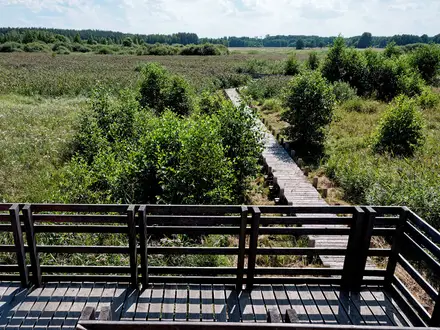
Tyrrel's Wood
Tyrrel's Wood is a route highlight rather than an overnight stop. The Boudicca Way crosses this ancient-woodland nature reserve on boardwalk paths, making it one of the most distinctive natural sections of the trail.
Plan it as part of the day between Tasburgh and Pulham Market. In wet periods, expect woodland paths and adjoining field sections to be muddy, and allow time rather than treating this as fast lane walking.
Hempnall
Hempnall lies near the route rather than as a main signed overnight hub in the standard stage plan. It may be useful for walkers arranging off-route accommodation or transport, but any diversion should be planned carefully.
Because the Boudicca Way’s middle section has limited services, a nearby village can be valuable if beds are unavailable directly on the trail. Distances from the path, access routes, food options and bus times should be checked before travelling.
Fritton
Fritton is passed on the way south towards Pulham Market. It is best treated as a small route village rather than a dependable overnight or resupply point.
This is the kind of section where the Boudicca Way rewards advance planning. Carry lunch and water, and have the day’s accommodation fixed before setting out from Tasburgh or the previous stop.
Pulham Market
Pulham Market is one of the strongest overnight stops in the middle-to-late part of the Boudicca Way. It is a traditional south-Norfolk village around a green and has a pub/B&B on the trail, making it a practical place to break the walk before the final stage to Diss.
On the 4-day split, Tasburgh to Pulham Market is about 12 km, followed by Pulham Market to Diss at about 14 km. This creates two manageable days and reduces the risk of being caught without services in the southern section.
Pulham Market is also a useful pause point for walkers using a 3-day itinerary, though the exact split will depend on accommodation availability. Book early, especially if relying on the pub/B&B for both bed and food.
Tivetshall St Mary
Tivetshall St Mary is a useful place to consider on longer or alternative stage plans, particularly for walkers compressing the Boudicca Way into three days. Accommodation is available in this part of the route corridor, but it is limited.
Do not build an itinerary around Tivetshall St Mary without checking bed availability, food arrangements and onward mileage. It can be practical, but it does not have the flexibility of Norwich, Pulham Market or Diss.
Shimpling
Shimpling lies on the southern approach towards Diss. For most walkers it is a through-village on the final day rather than a planned overnight stop.
By this point the finish is within the final stage from Pulham Market to Diss, so the simplest plan is usually to continue to Diss for trains, food and accommodation. If stopping short, all arrangements should be made in advance.
Frenze
Frenze is close to the end of the route near Diss and is not normally needed as an overnight stop. It is more relevant as part of the final rural approach before reaching the market town.
There is little reason to end a day here unless using a bespoke pick-up or local accommodation arrangement. Diss is the practical finishing base.
Diss
Diss is the official finish of the Boudicca Way, with the trail ending at Diss railway station in the market town near the Suffolk border. It is the best place to finish the walk, find onward transport, eat, or stay overnight after the route.
Diss has the strongest accommodation choice after Norwich and is far more practical than trying to stop short in the final villages. The town is also set beside Diss Mere, which gives a clear and worthwhile finish point before heading to the station.
Diss railway station is on the Norwich–London Liverpool Street line via Ipswich, making the route simple to complete car-free. If travelling home the same day, check train times before setting out on the final stage so there is enough time for delays, muddy field sections or a slower finish.
Getting to the Start
By train
The Boudicca Way starts at Norwich railway station, making this one of the simpler long-distance paths in Norfolk to begin without a car. The route leaves the station area and heads out of the city along the River Wensum/Yare via Carrow Bridge and Trowse, so no onward transfer is normally needed to reach the official start.
Norwich is on the Norwich–London Liverpool Street line via Ipswich. This is also the line used at the end of the walk, as the trail finishes at Diss railway station, so a car-free end-to-end itinerary is straightforward.
Check current train times, engineering works and any seat-reservation requirements before booking accommodation around a fixed arrival time. This should be checked before travelling.
By bus
Bus travel is most useful for section-walking the Boudicca Way rather than for reaching the official start, because the start is already at Norwich railway station. Local buses run between Norwich and villages along the route, which can help with day walks or shorter linear sections.
Services, frequencies and evening/Sunday coverage can change, especially in rural south Norfolk. This should be checked before travelling, particularly if relying on a bus to return from a village such as Shotesham, Tasburgh or Pulham Market.
By car
Driving to the start is possible, but it is less convenient than using the railway because the route is point-to-point from Norwich to Diss. If leaving a car in Norwich, the usual return plan is to travel back from Diss to Norwich by train at the end of the walk.
Long-stay parking options, charges and overnight rules in Norwich should be checked before travelling. Avoid assuming that small villages on the route will have suitable all-day or overnight parking, as facilities are limited outside the larger settlements.
From the nearest airport
For most walkers, the simplest approach is to travel to Norwich railway station and start the trail from there. If flying in, choose an airport based on available flights and onward public transport to Norwich; the practical transfer will usually involve rail and may require changes.
Airport-to-Norwich journey times and late-arrival connections should be checked before booking accommodation for the first night. This should be checked before travelling.
Where to stay before starting
Norwich is the best place to stay before starting the Boudicca Way. It has the widest choice of accommodation at the northern end of the trail, and staying in the city allows an easy morning start directly from the railway station.
This is especially useful if walking the route over 3–4 days, as mid-route accommodation is limited and spread out. Book the first night and all onward stops before setting off, particularly if walking at weekends or during the main spring-to-autumn walking season.
Getting Home from the Finish
By train
The Boudicca Way finishes at Diss railway station, which makes the end of the walk straightforward for car-free hikers. Diss is on the Norwich–London Liverpool Street mainline via Ipswich, so onward travel is usually much simpler than on many rural long-distance paths.
For most walkers, the train is the default way home. It is also the easiest way to return to Norwich if you left a car there or started the walk from Norwich railway station.
Timetables, engineering works and last trains should be checked before travelling, especially if finishing on a Sunday, bank holiday or late in the evening. If you are walking the final Pulham Market to Diss stage at a relaxed pace, plan around the last practical train rather than assuming there will be a late service.
By bus
Local buses run between Norwich and villages along the Boudicca Way, which is why the route works well as a series of linked day walks. For leaving the finish at Diss, however, the railway is normally the more dependable and direct option.
Bus services in rural south Norfolk can be limited compared with trains, particularly outside weekday daytime hours. If relying on a bus from Diss or from a village before the finish, current routes and times should be checked before travelling.
By car/taxi
If using a car, the simplest arrangement is usually to park at one end and use the train between Norwich and Diss. Because both ends have railway stations on the same mainline, this avoids complicated rural pick-ups.
Taxis are useful if you finish late, are staying away from the station, or need to reach accommodation in or around Diss. Do not assume taxis will be waiting at the station at quieter times; pre-booking is sensible, especially on Sundays, bank holidays or after an evening finish.
From the nearest airport
For flights after the walk, the practical first step is to leave Diss by train, either north towards Norwich or south via Ipswich towards London Liverpool Street. Airport connections beyond that depend on your chosen airport and should be checked before travelling.
Allow a generous buffer if connecting to a flight on the same day as finishing the trail. The final day is not technically hard, but muddy paths, overgrowth, navigation pauses and reduced evening transport can all slow the finish.
Where to stay at the finish
Diss is one of the best places on the route to stay overnight, with more services than the smaller mid-route villages. It is a sensible option if you expect to finish late, want a relaxed final day, or have a long onward journey the next morning.
Accommodation should still be booked ahead rather than left to chance. The Boudicca Way has thin accommodation in its middle sections, but both Norwich and Diss offer the fullest choice at the ends of the walk.
Which Direction Should You Walk?
The Boudicca Way is best walked in the standard north-to-south direction, from Norwich railway station to Diss railway station. This is how the route is normally described, and it matches the natural order of the trail: leaving Norwich via the River Wensum/Yare, passing through Trowse and the Tas valley, then continuing through south-Norfolk villages and farmland to the market town of Diss.
Reverse walking is entirely practical. The route is point-to-point, waymarked and named on OS mapping, and both ends are on the Norwich–London Liverpool Street rail line via Ipswich. There is no major climb, pass or technical section that makes one direction physically easier than the other.
Norwich to Diss: the standard direction
This is the simplest direction for most end-to-end walkers. Norwich has the widest choice of pre-walk accommodation and services, so it is a convenient place to arrive the night before, buy food, and start straight from the railway station.
The scenery also works well in this direction. The walk begins with an easy exit from the city along the river corridor, then becomes progressively more rural through Trowse, Arminghall, the Tas valley, Shotesham, Tasburgh, Tyrrel's Wood, Pulham Market and the quiet farmland towards Diss.
Finishing in Diss gives the walk a clear endpoint: the market town, Diss Mere, and the railway station for the journey home. For a short long-distance trail, that compact town finish usually feels more satisfying than ending at a busy city station.
Diss to Norwich: when the reverse makes sense
Walking from Diss to Norwich can be useful if train timings, accommodation availability or linked day-walk logistics work better that way. Because both ends have mainline railway stations, there is no serious transport penalty for reversing the route.
The reverse direction gives a more urban finish. After several days of farmland, villages and river-valley walking, the final approach brings you back through Trowse and into Norwich. That may suit walkers who want the largest choice of food, accommodation and onward transport at the end.
However, reverse walkers should take just as much care over the middle section. Beds and food options are limited and spread out between the main villages, so overnight stops around Pulham Market, Tasburgh, Shotesham or nearby alternatives still need booking in advance.
Gradient, weather and waymarking
There is no meaningful gradient advantage either way. The Boudicca Way is lowland walking, with no summit and only gentle rises spread across the route, so direction should not be chosen for easier climbing or descending.
Prevailing wind is not a major planning factor for this trail. Much of the route crosses open field edges, farm tracks and quiet lanes, so exposed sections can feel harder in poor weather whichever way you walk. Check the forecast before setting off, especially in winter mud or after prolonged rain.
Waymarking can vary in places, and summer growth may obscure paths or signs. Carry OS mapping or a reliable digital map in either direction; do not rely solely on waymarks, particularly through field-edge sections and around junctions.
Recommendation
Walk the Boudicca Way from Norwich to Diss unless there is a specific transport or accommodation reason to reverse it. The standard direction has the easiest start logistics, the best countryside progression, and a satisfying finish at Diss Mere and Diss railway station, while the reverse is a perfectly workable alternative for section-hikers or walkers fitting the trail around trains and available beds.
Accommodation Along the Route
Accommodation is the main planning constraint on the Boudicca Way. The walking is straightforward, but the route runs through small south-Norfolk villages where beds and evening food can be sparse, especially through the middle stages.
Norwich and Diss are the strongest accommodation bases. Both have mainline railway stations, so they are also the easiest places to build in a pre-walk or post-walk night without needing a car.
Between the two ends, expect limited choice: a few pubs, inns, B&Bs, guesthouses, a shepherd's hut and campsites along or just off the route. Do not rely on turning up and finding a room on the day. Book overnight stops before committing to daily distances, and check whether evening meals are available at the same place or nearby.
Best overnight stops
For a relaxed 4-day walk, the most workable split is usually:
- Norwich — start night or early train arrival
- Shotesham — natural first overnight area after the longer opening stage
- Tasburgh — useful short-stage stop in the Tas valley
- Pulham Market — good late-route village stop with pub/B&B provision on the trail
- Diss — finish night or train home
A 3-day split is possible, but it gives less flexibility because the middle of the trail has fewer accommodation options. Tivetshall St Mary can work as an alternative longer-stage stopping point before Diss, but availability should be checked before planning around it.
Fit walkers sometimes complete the route in 2 long days, but that puts even more pressure on choosing a workable overnight point in the middle. For most walkers, the route is easier to arrange as a booked inn/B&B walk over 3–4 days or as separate day walks using buses and the railway at each end.
Accommodation by place
| Place | Accommodation level | Best for | Notes |
|---|---|---|---|
| Norwich | Good | Pre-walk night, late arrival, widest choice | Best place to stay before starting. The route begins at Norwich railway station, so an overnight here keeps the first morning simple. |
| Trowse / Arminghall | None as a main overnight hub | Passing through from Norwich | These are early-route places rather than practical accommodation targets. Stay in Norwich if starting slowly. |
| Upper Stoke / Stoke Holy Cross area | Limited | Camping-based or short first-day option | An Upper Stoke campsite is one of the limited camping options along or near the route. Check opening dates, booking requirements and food plans before relying on it. |
| Shotesham | Limited | First night on a 4-day itinerary | A natural first-night area after the Norwich stage, but rural accommodation is limited. Book early and check evening meal availability. |
| Saxlingham Green / Saxlingham Nethergate | Limited to none as a planning hub | Contingency only | Treat this section as rural through-walking unless accommodation has been booked in advance nearby. |
| Tasburgh | Limited | Short second-stage stop, Tas valley base | A useful overnight point for a 4-day split. Availability is limited, so it should be secured before fixing the itinerary. |
| Tyrrel's Wood / Hempnall / Fritton area | Limited to none as a planning hub | Day section rather than overnight target | This is one of the thinner parts of the route for beds and food. Carry enough supplies and avoid assuming there will be services en route. |
| Pulham Market | Limited | Main late-route overnight stop | One of the better mid-to-late route stops, with pub/B&B provision on the trail. Still book ahead, particularly for weekends. |
| Tivetshall St Mary | Limited | Alternative stop on a 3-day or longer-stage itinerary | Can help divide the southern half of the walk, but choice is limited and should be checked before travelling. |
| Shimpling / Frenze | None as a main overnight hub | Final-day through-walking | Plan to continue to Diss or arrange a pre-booked transfer if accommodation is elsewhere. |
| Diss | Good | Finish night, onward rail travel | The best accommodation base at the southern end. The trail finishes at Diss railway station, close to the market town and Diss Mere. |
Booking strategy
Book the middle nights first, then arrange Norwich and Diss around them. There is little point fixing train tickets or daily stage lengths until the limited village accommodation has been secured.
Weekend and high-season availability can be tight simply because there are so few beds in the smaller villages. Spring, summer and autumn are the main walking seasons, so Fridays and Saturdays should be treated as the highest-risk nights for availability.
If accommodation is a little off the line of the route, a taxi transfer can make the itinerary work, especially between the thinner middle sections and the stronger bases at either end. Pre-book any taxi movements rather than assuming rural availability at short notice. A dedicated luggage-transfer service should be checked before travelling; it should not be assumed as part of the route.
Camping and inn-to-inn walking
Camping is possible only with planning, not as a spontaneous campsite-to-campsite walk. The known provision includes a campsite around Upper Stoke, but the route does not have regular formal campsites at every natural stage break.
The Boudicca Way can work well as an inn-to-inn or B&B walk, but only if treated as a fixed-booking route. The practical approach is to secure beds at Shotesham, Tasburgh, Pulham Market or Tivetshall St Mary first, then adjust the daily mileage to match what is actually available.
Camping and Wild Camping
Campsites and booked camping
The Boudicca Way can be done as a camping trip, but it needs more planning than many upland routes. Campsites and camping-style accommodation are limited and spread out, and the middle of the trail has thin accommodation and food options, so pitches should be booked before setting off.
Known camping possibilities are on or just off the route around places such as Upper Stoke, Tasburgh, Pulham Market, Tivetshall and Diss. Availability, opening dates, exact access from the trail and whether tents are accepted should be checked before travelling.
| Area | How it fits into a camping itinerary | Planning notes |
|---|---|---|
| Norwich / Trowse | Useful before starting the walk | Norwich has the fullest accommodation choice, but city camping options may require extra travel. |
| Upper Stoke / Stoke Holy Cross area | Possible early-route camping area south of Norwich | Useful if splitting the first day shorter than Norwich to Shotesham. Check exact location and access. |
| Tasburgh | Practical mid-route area on a 4-day split | Accommodation is limited, so do not rely on turning up without a booking. |
| Pulham Market / Tivetshall | Useful for the southern half of the trail | These areas work well before the final approach to Diss, but options are spread out. |
| Diss | Finish-night option | Handy if finishing late or connecting with trains the following morning. |
Because the route is only 58 km / 36 miles and both ends have mainline railway stations, many walkers will find B&Bs, pubs or inns simpler than carrying camping kit. Camping still works well for lightweight walkers, but the overnight stops may dictate the stage lengths more than the official or common walking splits.
Wild camping
Wild camping is not a good default plan for the Boudicca Way. This is lowland England, with the route crossing public rights of way, field edges, farm tracks, byways, quiet lanes, villages and nature-reserve land; most of the surrounding land is private farmland.
In England there is no general right to wild camp without the landowner’s permission. If you want to camp away from an official site, permission should be arranged in advance with the landowner. Do not assume that a quiet field corner, woodland edge or river meadow is acceptable simply because it is away from a road.
Avoid any idea of camping in sensitive or inappropriate places on this route, including Tyrrel’s Wood nature reserve, the boardwalk sections, churchyards, village greens, archaeological sites such as Venta Icenorum and Tasburgh ringwork, or on cropped farmland and grazing land. These are not suitable overnight places.
Water and cooking
Plan water around booked accommodation, villages and staffed services. The route follows the Tas valley and passes near rivers and wet ground in places, but natural lowland water beside farmland should not be relied on as a drinking source without proper treatment, and access may be awkward or inappropriate.
Carry enough water between overnight stops, especially in warm weather when field-edge walking and limited shade can make the day feel hotter than the modest distance suggests. Public taps and out-of-hours water access should not be assumed; this should be checked before travelling.
Open fires are not appropriate on this route. Use a stove only where permitted by a campsite or accommodation provider, and take extra care in dry summer conditions around crops, hedges and woodland edges.
Seasonal considerations for campers
Spring and autumn are usually the most practical seasons for camping, with milder temperatures and less vegetation than high summer. After wet weather, expect muddy or waterlogged paths, wet grass and slow going on field edges.
In summer, brambles, nettles and overgrowth can make some sections harder with a full pack. A compact tent, waterproof stuff sacks and footwear that can cope with mud are more useful here than heavy expedition-style kit.
Leave No Trace on the Boudicca Way
Keep camping impact very low on this rural route:
- use booked campsites or camp only with clear landowner permission;
- keep off crops, grazing land, archaeological earthworks and nature-reserve areas;
- take all litter away, including food scraps and used tissues;
- do not light fires or cut wood;
- keep noise down near villages and isolated houses;
- leave gates as found and avoid disturbing livestock;
- never block field entrances, tracks, boardwalks or rights of way.
Food, Water and Resupply
The Boudicca Way is not a wilderness route, but its resupply is more limited than the map of villages suggests. Norwich and Diss are the reliable places to buy a full food supply; between them, facilities are scattered and rural opening hours can be short, seasonal or affected by Sunday and bank-holiday closures.
For an end-to-end walk, plan each day as if there may be no guaranteed shop between overnight stops. Carry lunch, snacks and enough water from the start of the day, then treat pubs, cafés or village services as useful extras rather than essential resupply points unless they have been checked before travelling.
Where food is easiest
Food is easiest at the two ends of the route. Norwich has the fullest choice before starting, and Diss is the best place to eat or restock at the finish.
On the trail itself, accommodation and food options are thin and spread out. The brief identifies pubs, inns, B&Bs, a shepherd’s hut and campsites along or just off the route, including around Upper Stoke campsite, Tasburgh, Pulham Market and Tivetshall, but availability must be planned around booked accommodation and current opening times.
Pulham Market is a natural mid-route rest point and has a pub/B&B on the trail. Shotesham, Tasburgh and Tivetshall can work as overnight or pause points, but should not be treated as guaranteed resupply without checking current services.
Water planning
Use tap-water refills wherever possible: accommodation, pubs, cafés and official visitor facilities when open. Ask to refill bottles before leaving each overnight stop, especially on the middle stages where there are fewer dependable services.
The route follows the Tas valley and passes lowland rivers, ditches and wet woodland, but natural water should not be treated as a routine drinking source. This is agricultural lowland country, so any emergency use of river or ditch water would need proper filtration or treatment, and even then should be a last resort.
For most walkers, carrying 1.5–2 litres from the start of each stage is sensible in normal conditions. In hot weather, or if walking a longer 2- or 3-day itinerary, carry more and start with a full supply from Norwich, booked accommodation or a confirmed open stop.
| Section | Food availability | Water availability | Notes |
|---|---|---|---|
| Norwich to Shotesham | Good in Norwich before starting; limited once beyond the city and Trowse. Do not rely on a shop or meal stop later in the day unless checked. | Fill bottles in Norwich before setting off. Possible refills only where services are open. | This is the longest standard stage at about 21 km, so carry lunch and snacks from Norwich. |
| Shotesham to Tasburgh | Limited rural provision. Food may depend on booked accommodation or any confirmed open pub/café. | Refill at accommodation before leaving Shotesham and again at Tasburgh if staying there. | Shorter stage, but still plan self-sufficiently between villages. |
| Tasburgh to Pulham Market | Sparse mid-route services through rural farmland and woodland, including the Tyrrel’s Wood section. | Start full from Tasburgh. Refill only at confirmed open services or accommodation. | Carry the day’s food; Pulham Market is the most useful planned rest point on this section. |
| Pulham Market to Diss | Limited until Diss. Do not assume food at every village on the way. | Fill up before leaving Pulham Market; reliable options return at Diss. | About 14 km to the finish, so a light lunch and snacks are usually enough if starting well supplied. |
Practical resupply tips
Book accommodation first, then build food plans around it. If a pub meal is important, check serving times before travelling and ask whether food is served on the specific night of the stay.
Carry at least one spare meal or substantial snack on the middle of the route. This is particularly useful if a rural pub is closed, a bus connection is missed, or the day takes longer because of mud, overgrowth or navigation delays.
Sunday walking needs extra care. Rural shops, cafés and pubs may have reduced hours or may not serve food all day; this should be checked before travelling.
If camping, do not assume there will be a shop beside the campsite. Buy stove food before leaving Norwich, Diss or a confirmed resupply point, and check campsite rules and facilities when booking.
Terrain, Conditions and Difficulty in Practice
The Boudicca Way is physically straightforward by hillwalking standards: lowland, non-technical and never high. The highest ground is only around 68 m, and the total ascent of about 499 m is spread across the full 58 km, so there are no sustained climbs or steep descents to plan around.
What makes the route feel harder in practice is not gradient, but surface, season and navigation. Much of the walk uses field-edge paths, farm tracks, byways, river-valley paths and quiet lanes, with some sections that become muddy after rain and others that can be overgrown in high summer.
Underfoot: what you actually walk on
Expect a typical south-Norfolk mix rather than a built trail surface. The route leaves Norwich on urban and riverside paths via the River Wensum/Yare, Carrow Bridge and Trowse, then becomes increasingly rural through the Tas valley and the farmland south towards Diss.
The main surfaces are:
| Terrain type | What it means in practice |
|---|---|
| Field edges and public footpaths | Usually easy walking, but can be uneven, muddy, narrow or overgrown depending on land management and season. |
| Farm tracks and byways | Generally firmer and easier to follow, though rutted or wet sections are possible after rain. |
| River-valley paths along the Tas | Low-lying ground can hold water in wet periods; expect softer going than on lanes or tracks. |
| Quiet country lanes | Useful for linking villages and field paths; not technically difficult, but take care on narrow lanes without pavements. |
| Boardwalk through Tyrrel’s Wood | A distinctive woodland section and usually easier than wet woodland floor, but timber can be slippery when damp. |
There is no rocky ground, scrambling, exposed ridge walking or technical terrain. Trail shoes are often adequate in dry conditions, but waterproof walking shoes or lightweight boots are a better choice after sustained rain or outside the driest months.
Mud, waterlogging and overgrowth
Winter and wet spells are the main reasons this route can feel slower than its profile suggests. Low-lying paths, field margins and river-valley sections can become muddy or waterlogged, particularly where many walkers, dogs or farm vehicles have churned the ground.
In high summer, the issue changes from mud to vegetation. Brambles and nettles can narrow some field-edge paths and make shorts a poor choice on overgrown stretches. Lightweight long trousers are sensible in summer, even though the route is not remote or mountainous.
Spring and autumn usually offer the best balance: enough daylight for comfortable stages, fewer overgrown paths than high summer, and generally better surfaces than winter. After heavy rain, allow more time than the distance alone suggests.
Climbs, descents and exposure
There are no significant climbs on the Boudicca Way. The route crosses gentle rolling farmland above the Tas valley, but the height gain comes in small rises rather than sustained uphill walking.
Exposure is minimal in the mountain sense, but the route is open in places. Across farmland there may be little shelter from wind, rain or strong sun, so waterproofs, sun protection and enough water still matter, especially on the thinner middle sections between villages.
Road walking and lanes
The route follows public rights of way and quiet lanes rather than staying entirely off-road. Lane sections are part of the practical character of the walk and help connect villages such as Shotesham, Saxlingham Nethergate, Tasburgh, Pulham Market and the smaller settlements towards Diss.
These roads are not a technical difficulty, but they do require attention. Walk facing oncoming traffic where there is no pavement, be visible in poor light, and avoid relying on headphones on narrow rural lanes.
Waymarking and navigation
The Boudicca Way is waymarked and named on Ordnance Survey mapping, but the waymarking is not consistently strong throughout. Some rural path junctions, field edges and lane transitions need careful checking, particularly where the obvious trodden line is not necessarily the right of way.
Carry proper mapping rather than relying only on signs. OS Explorer 230 and 237 cover the route area, and a GPX or strip-map can be useful for quick checks at field corners and village exits. Navigation is not complex, but missed turns can add frustrating distance on a lowland route where landmarks are often subtle.
Stiles, gates and access points
The main route uses public rights of way through farmland and villages, so expect a mix of path furniture such as gates, field entrances and boundary crossings. Exact stile locations and current condition can change with maintenance and land management, so this should be checked before travelling if step-free access is important.
A stile-free / powerchair-accessible variant exists via the Norwich Access Group. Anyone needing a barrier-free version should plan around that route rather than assuming the standard Boudicca Way is fully accessible.
Livestock and dogs
The walk is generally suitable for dogs on easier sections, but it crosses working countryside. Keep dogs under close control on farmland, use leads where required, and be ready for gates, crops, livestock fencing or temporary diversions linked to land management.
Do not assume water, shade or dog-friendly indoor stops will be available throughout the middle of the trail. The route passes through villages, but services are spread out and the quieter sections need enough food and water carried from the start of the day.
Why the difficulty is easy-to-moderate, not just easy
On paper, this is an easy long-distance path: low elevation, no technical ground and excellent rail access at Norwich and Diss. For a single day section in good weather, most reasonably fit walkers will find the walking straightforward.
For a full end-to-end walk, the difficulty rises because of cumulative distance, limited mid-route facilities, muddy field paths after rain, summer brambles and occasional weak waymarking. The challenge is therefore logistical and underfoot rather than athletic: plan the stages well, carry navigation, and choose footwear for the season rather than for the gradient.
Weather and Best Time to Walk
The Boudicca Way is best treated as a spring, summer or autumn walk. The route is low, inland and non-technical, so weather rarely creates mountain-style hazards, but it has very practical seasonal problems: muddy field edges after rain, waterlogged lowland paths in winter, and brambles or nettles on under-used sections in high summer.
Best time to walk
For most walkers, the best windows are late spring to early summer and early autumn. These periods give a good balance of usable daylight, less winter mud and, outside the most overgrown part of summer, easier progress along field margins and farm tracks.
High summer is perfectly possible, but expect more vegetation. Some sections can become overgrown with brambles and nettles, so long trousers or gaiters are useful even in warm weather.
Autumn can be one of the better times for an end-to-end walk, provided there has not been prolonged rain. Field-edge paths and farm tracks can deteriorate quickly once the ground is wet.
Season-by-season planning
| Season | What to expect | Practical advice |
|---|---|---|
| Spring | Often the most straightforward season for the route: improving daylight, fresh vegetation and generally easier going than winter. | Still plan for mud after rain, especially on field edges and low paths near the Tas valley. Waterproof footwear is sensible. |
| Summer | Long days make the 3–4 day itinerary easy to manage, but field margins can be overgrown with brambles and nettles. Open farmland sections can also feel exposed in hot weather. | Carry enough water between villages, use sun protection, and wear clothing that can cope with nettles and scratchy growth. Check current path conditions before relying on fast timings. |
| Autumn | Good walking conditions are possible early in the season, with less aggressive vegetation than summer. Later autumn becomes muddier after rain. | Allow extra time if the ground is wet. Shorter days make early starts more important on longer stage options. |
| Winter | The route remains physically realistic because it is flat and low-level, but this is the least convenient season. Mud, waterlogging and short daylight are the main issues. | Choose shorter sections, carry reliable navigation, and avoid assuming field paths will be quick. A full end-to-end winter walk is possible for prepared walkers, but it is less beginner-friendly. |
Rain, mud and underfoot conditions
Rain matters more than cold on the Boudicca Way. The trail uses public footpaths, field edges, farm tracks, byways, quiet lanes and a boardwalk section through Tyrrel's Wood, so surface conditions change frequently.
After wet weather, expect slower progress through farmland and along low-lying paths. Mud is most likely to affect timing on the middle rural sections, where there are fewer immediate facilities and fewer easy bail-out options than at Norwich or Diss.
Waterproof boots or trail shoes with good grip are preferable outside dry summer conditions. Lightweight road-running footwear is a poor choice after rain, even though the route has no climbs or technical ground.
Heat, exposure and water
The Boudicca Way has no high ground, but it crosses open south-Norfolk farmland where shade can be limited. In warm weather, the lack of climbing can make the walk feel deceptively easy, but the cumulative 58 km still needs proper water and food planning.
Do not assume every village has convenient all-day supplies. The middle of the trail is thin on services, so water, lunch and snacks should be planned before leaving each overnight stop.
Wind, storms and woodland
Strong wind is rarely a route-stopping issue on this lowland walk, but open field sections can feel exposed. In stormy weather, take extra care around trees, especially through woodland sections such as Tyrrel's Wood.
If thunderstorms or high winds are forecast, adjust the day rather than relying on the route being sheltered. There is no mountain exposure, but there are enough field-edge and woodland paths for poor weather to slow progress and make navigation less comfortable.
Fog, low light and navigation
Fog and poor light can make waymarking gaps more awkward, particularly where the route crosses farmland or follows field edges. The Boudicca Way is waymarked and named on Ordnance Survey mapping, but waymarking varies, so a map, GPX or reliable offline navigation is useful in any season.
In winter and late autumn, short daylight increases the risk of finishing on lanes or field paths in the dark. Plan conservative stage lengths unless the route is already familiar.
Accommodation and seasonal availability
Accommodation is limited and spread out between Norwich and Diss, especially in the middle of the route around the smaller villages. This matters more than weather when choosing dates: overnight stops should be booked before committing to a 3–4 day itinerary.
Summer weekends and holiday periods can reduce flexibility, while some rural pubs, inns, B&Bs or campsites may have changing opening patterns. Accommodation availability, food options and current prices should be checked before travelling.
Safety Notes
The Boudicca Way is a lowland, non-technical walk, but it should not be treated as risk-free. The main issues are navigation gaps, mud or overgrowth, long field-edge sections, limited facilities in the middle of the route, short stretches on quiet lanes, and exposure to heat, cold or rain across open farmland.
In an emergency in the UK, call 999 or 112 and ask for the appropriate service. Give the nearest village, road, grid reference or identifiable landmark; carrying an OS map, GPX file or mapping app makes this much easier.
Navigation and remoteness
The route is waymarked and named on Ordnance Survey mapping, but waymarking can vary. Carry a map or offline route file rather than relying only on signs, especially between the smaller villages south of Norwich and before Diss.
The middle of the trail has fewer services than the end towns. Do not assume there will be food, water, toilets or public transport exactly when needed; check each day’s options before setting off and carry enough supplies to reach the next planned stop.
Mobile signal should not be relied on as the only safety system. Download maps, save accommodation and transport details offline, and tell someone your planned finish point if walking alone.
Roads, lanes and farm tracks
The Boudicca Way follows public rights of way, farm tracks, byways and quiet country lanes. On lane sections, walk facing oncoming traffic where there is no pavement, use a torch or reflective clothing in poor light, and take care at bends and high hedges where visibility is limited.
The route runs broadly parallel to the old Roman Pye Road / A140 corridor, but the walk itself is mainly rural. Any road crossings or linking lane sections should still be treated carefully, particularly at the start and end of the day when tiredness can affect judgement.
Mud, overgrowth and seasonal ground conditions
Winter and wet spells can leave field edges, river-valley paths and farm tracks muddy or waterlogged. Waterproof footwear with decent grip is more useful here than heavy mountain boots, but trainers can be a poor choice after rain.
In high summer, brambles, nettles and long vegetation can slow progress and obscure the path in places. Long trousers, a lightweight long-sleeved layer and a basic first-aid kit are sensible on the more overgrown sections.
Boardwalk paths through Tyrrel’s Wood can be slippery when wet or leaf-covered. Take extra care there, particularly with dogs or when carrying a heavier pack.
Weather exposure
There are no high hills on the Boudicca Way, but much of the route crosses open south-Norfolk farmland with limited shelter. Wind, rain and cold can still become uncomfortable on a long day, especially if progress is slowed by mud.
In warm weather, the open fields can feel exposed and shade may be intermittent. Start early on hot days, carry enough water, and plan breaks around villages or wooded sections rather than assuming shade will be available throughout.
Livestock, dogs and countryside access
Expect working farmland, field boundaries and occasional livestock. Keep dogs under close control, use leads around animals, and close gates behind you.
Give cattle, horses and sheep plenty of space, and avoid walking between adult animals and their young. If a dog causes livestock to react, let go of the lead rather than being pulled into danger.
Rivers, water and wet ground
The route uses river-valley paths along the Wensum/Yare near Norwich and the Tas valley further south, and finishes in Diss near Diss Mere. Stay on the path near water, keep children and dogs close, and avoid unstable or undercut banks.
Do not enter floodwater or try to force a waterlogged section if the safe line is unclear. After prolonged rain, paths beside rivers and low-lying meadows may be slower or less pleasant; local conditions should be checked before travelling.
Solo walking
The trail is suitable for solo walkers with normal precautions. The key safety step is logistics: book accommodation, know where food and water are available, and have a realistic exit plan using local buses or the railway at Norwich and Diss.
If walking long stages, share the day’s start and finish points with someone else and update them on arrival. Carry a power bank if using a phone for navigation.
Check before setting off each day
- Weather forecast, including heat, heavy rain and wind.
- Daylight hours and expected finishing time.
- Current train and local bus times if relying on public transport.
- Accommodation check-in arrangements and evening food options.
- Water and food needed for the next section, especially through the thinner middle of the route.
- Map, GPX or guidebook access offline.
- Phone battery, power bank and emergency contact details.
- Footwear and clothing suited to mud, overgrowth or exposed field walking.
Gear Recommendations
The Boudicca Way does not need mountain kit, but it does reward practical lowland walking gear. The main gear issues are muddy field edges and farm tracks after rain, summer brambles and nettles, exposed lanes and farmland, limited mid-route services, and waymarking that is not always consistent.
Footwear
Lightweight walking shoes or trail shoes are suitable in a dry spell. The route is low, mostly non-technical and has no serious climbs, so heavy mountain boots are unnecessary for most walkers.
In winter, after prolonged rain, or if carrying camping kit, waterproof walking boots or sturdier shoes are a better choice. Field-edge paths, byways and farm tracks can become muddy or waterlogged, and a grippier sole is more useful than ankle support on this route.
Gaiters are worth considering outside summer. They help with mud, wet grass and the bramble/nettle growth that can affect some rural sections.
Waterproofs and clothing
Carry a waterproof jacket in all seasons. South-Norfolk farmland can feel exposed in poor weather, and there are long stretches where shelter is limited between villages.
Waterproof trousers are optional in settled summer weather but useful in spring and autumn, and strongly recommended if rain is forecast. Wet crops, long grass and muddy paths can soak trousers even when rainfall is light.
A warm layer is still sensible despite the low altitude. The route’s high point is only around 68 m, but a damp or windy day in open country can feel cold, especially when stopping for food or waiting for transport.
In high summer, long trousers or calf protection are preferable to shorts on overgrown sections. Brambles and nettles can be more of a nuisance here than the terrain itself.
Navigation
Do not rely on waymarks alone. The Boudicca Way is waymarked and named on Ordnance Survey mapping, but waymarking varies and some sections need careful attention through fields, lanes and village edges.
Useful mapping options include:
| Navigation item | Why it matters on this route |
|---|---|
| OS Explorer 237 and 230 | Detailed mapping for the Norwich and Diss ends of the trail |
| OS Landranger 134, 144 and 156 | Broader-scale backup mapping for the full corridor |
| Offline map or GPX on a phone | Helpful where rights of way cross fields or waymarks are missed |
| Power bank | Important if using the phone for mapping over multiple days |
| Printed map extract or guide/strip-map | Sensible backup if batteries fail or the route becomes unclear |
Download maps before leaving Norwich or Diss. Mobile reception should not be treated as a navigation plan, particularly in the quieter middle of the route.
Water and food carry
Carry enough water for a half-day at minimum, and more in hot weather. Villages are spaced along the route, but services are limited in the middle section and should not be assumed without checking opening times before travelling.
For most walkers, 1.5–2 litres is a practical starting capacity for a normal day. Increase this in summer, when walking longer stages, or when camping.
Food planning matters more than the easy terrain suggests. Carry lunch and spare snacks each day, especially between Shotesham, Tasburgh, Pulham Market and the quieter rural stretches towards Diss. Do not plan around finding food at every village.
Trekking poles
Trekking poles are optional. There is no sustained ascent or descent, and the total climbing is modest across the whole 58 km.
They can be useful after rain, particularly on greasy field paths, muddy byways and wet boardwalk approaches through woodland. Fast walkers and campers carrying heavier packs may also appreciate them for rhythm and stability.
For inn-to-inn hikers
Keep the pack light. The route is well suited to a small daypack or compact multi-day pack if accommodation has been booked in advance.
Prioritise waterproofs, spare socks, a warm layer, navigation, food for the day and a power bank. Accommodation is limited and spread out, so bookings should be made before setting off rather than relying on finding a bed late in the day.
Even when staying indoors, do not strip the kit too far. The rural middle of the route has limited facilities, and a missed turn or late finish can turn a short day into a much longer one.
For campers
Camping kit should be lightweight and pre-planned around known overnight options. Campsites and simple rural accommodation are limited along or near the route, with the fullest choice at Norwich and Diss and fewer options through the middle.
A small tent or shelter, season-appropriate sleeping bag, sleeping mat, stove if needed, headtorch, extra food and additional water capacity are the key items. Campsite availability and current arrangements should be checked before travelling.
Because the route is flat, pack weight is less punishing than on hill routes, but muddy ground and overgrown paths make bulky loads awkward. Keep the system compact and avoid carrying unnecessary extras.
For fast walkers and section hikers
Fast end-to-end attempts and linked day walks need reliable navigation and enough food and water to avoid wasting time detouring for supplies. The route is physically straightforward, but field paths and waymarking gaps can slow progress.
For section hikers using buses or trains, a power bank is strongly recommended. Phones often carry the map, GPX, bus times and train tickets, so battery failure creates more problems than on a circular local walk.
A small sit mat or lightweight insulated layer can be useful when waiting for transport in exposed villages or at either end station, particularly outside high summer.
Seasonal extras
| Season | Useful additions |
|---|---|
| Spring | Waterproof footwear, gaiters, warm layer, waterproof trousers after wet weather |
| Summer | Sun hat, sunscreen, extra water, insect repellent, long trousers for nettles and brambles |
| Autumn | Waterproofs, warmer spare layer, headtorch for shorter days, mud-ready footwear |
The Boudicca Way is best treated as a lowland countryside walk rather than a hill route. Leave technical mountain gear at home, but take mud, navigation, food carry and changing weather seriously.
Budget and Costs
The Boudicca Way is usually a relatively low-cost UK long-distance walk, mainly because it is short, has rail access at both ends, and needs no specialist equipment, permits or mountain transport. The main cost variable is accommodation: Norwich and Diss have the widest choice, while the middle of the route has limited beds and should be booked ahead.
All figures below are practical planning estimates in GBP. Prices vary by season, day of week and availability, so current prices should be checked before booking.
Typical cost approaches
| Style | Likely spend | What it usually means |
|---|---|---|
| Budget | £25–£60 per person per day, excluding travel to/from Norfolk | Camping where available, simple food bought in advance, buses for section links, minimal pub meals |
| Mid-range | £80–£150 per person per day, excluding travel to/from Norfolk | Pubs, inns, B&Bs or guesthouses, packed lunches plus a pub/café meal where available |
| Comfortable | £140–£230+ per person per day, excluding travel to/from Norfolk | Private rooms throughout, more meals out, taxi back-up or luggage moved by taxi where arranged |
For a 3–4 day end-to-end walk, the accommodation pattern matters more than the mileage. A cheap bed in Norwich or Diss is much easier to find than a last-minute room in the rural middle of the trail.
Accommodation costs
Norwich and Diss offer the best chance of controlling the budget, because they have the fullest choice of places to stay. Between them, options are much thinner and spread through villages such as Shotesham, Tasburgh, Pulham Market and Tivetshall, with pubs, inns, B&Bs, guesthouses, shepherd’s-hut-style stays and campsites either on or just off the route.
As a rough planning guide:
| Accommodation type | Typical planning range |
|---|---|
| Campsite pitch | £10–£25 per person/night |
| Simple B&B, guesthouse or pub room | £60–£120 per room/night |
| More comfortable room or high-demand date | £100–£170+ per room/night |
Camping can make the walk much cheaper, but campsites are not evenly spaced along the route. Upper Stoke is one known camping option, but any camping-based itinerary needs careful stage planning rather than assuming there will be a pitch at the right distance each day.
Food and drink
Food costs are easy to keep down if supplies are bought in Norwich, Diss or larger villages before starting each stage. The middle of the Boudicca Way is rural, and food stops are limited, so carry lunch, snacks and enough water rather than budgeting around cafés appearing at convenient intervals.
Allow roughly:
| Food style | Typical planning range |
|---|---|
| Supermarket breakfasts, packed lunches and snacks | £10–£20 per day |
| One pub meal or café stop where available | £15–£30+ per meal |
| Full pub/B&B dining approach | £30–£60+ per day |
A budget walker can keep food spend low by carrying supplies, but the cost in weight is worth considering on the longer first stage from Norwich to Shotesham.
Transport costs
The strongest budget advantage of the Boudicca Way is transport. The route starts at Norwich railway station and finishes at Diss railway station, both on the Norwich–London Liverpool Street line via Ipswich, so no expensive private transfer is normally needed for an end-to-end walk.
Train fares vary significantly depending on advance booking, route, railcard use and time of travel. Current fares should be checked before travelling.
Local buses between Norwich and villages along the route can make section-walking cheaper than paying for taxis. Timetables change, and rural services may be infrequent, so bus times should be checked before each walking day.
Taxis and luggage
A taxi contingency is sensible because accommodation and food options are sparse in the middle stages. Rural taxi costs can rise quickly if a pick-up is needed from a lane, village edge or off-route accommodation, so book in advance where possible and confirm the fare.
No standard dedicated baggage-transfer service is essential for this route. Walkers wanting luggage moved between overnight stops should expect to arrange it directly with local taxi operators or accommodation providers where available. This should be checked before travelling.
Package and guided-walk costs
The Boudicca Way is straightforward to organise independently, and most walkers will not need a guided package. If using a self-guided walking holiday provider, expect the price to be higher than booking accommodation and transport directly, because the package may include itinerary planning, accommodation reservations and support.
Availability of organised packages changes, so current options and inclusions should be checked before booking.
Luggage Transfer, Guided Tours and Support Services
Luggage transfer
The Boudicca Way is best treated as a lightly supported, self-managed trail rather than a route with a large dedicated baggage-transfer network. Its short length, easy terrain and strong rail access mean many walkers carry their own kit, especially on a 2- or 3-day itinerary.
Luggage transfer is still useful if you are walking with children, staying in B&Bs or pubs, or splitting the route into shorter stages such as Norwich–Shotesham–Tasburgh–Pulham Market–Diss. Because accommodation is limited in the middle of the route, arrange bag movements at the same time as booking beds, not after the itinerary is fixed.
In practice, support is most likely to be arranged through accommodation providers or local taxi firms rather than a fixed trail tariff. Ask each overnight stop whether they can accept bags before check-in, store luggage securely, and recommend a driver for the next transfer. This should be checked before travelling.
Keep the daytime essentials with you even if a bag is being moved: waterproofs, warm layer, food, water, phone power, map/GPX and any medication. Variable waymarking, muddy field edges and summer overgrowth can slow progress, so do not send everything ahead.
Self-guided walking packages
Self-guided packages, where available, are the most convenient supported option. These typically include pre-booked accommodation, route notes, maps or GPX files, and sometimes luggage transfer between overnight stops.
For this route, the key issue is bed availability rather than terrain. Any self-guided arrangement should be checked carefully around Shotesham, Tasburgh, Pulham Market and the smaller villages, where accommodation and evening food are much thinner than in Norwich and Diss.
Before booking, confirm:
| Question | Why it matters on the Boudicca Way |
|---|---|
| Are overnight stops on or off the route? | Small detours can be significant at the end of a day, especially where buses are infrequent. |
| Is luggage transfer included? | Some packages may only book accommodation and provide route material. |
| Are evening meals available or nearby? | Mid-route villages have limited food options. |
| Are route notes current? | Waymarking varies, and field-edge paths can change in feel through the farming year. |
| What happens if a stage is missed? | Buses and taxis can usually solve this, but rural transfers need planning. |
Guided walking
A guide is not normally necessary for the Boudicca Way. The route is lowland, non-technical and waymarked, and it starts and finishes at railway stations in Norwich and Diss.
Guided walking may still suit groups interested in the Iceni and Roman landscape, particularly around Venta Icenorum, Tasburgh ringwork and the old Roman Pye Road corridor. It can also help less confident walkers with navigation through field paths, lanes and the more poorly waymarked sections.
Scheduled guided departures are not an essential part of planning this trail. If a guided day or private group walk is preferred, arrange it in advance and check exactly which sections are covered, whether transport back to Norwich or Diss is included, and whether the guide provides route interpretation or simply navigation support.
Taxi and local transport support
Taxis are the most flexible back-up for luggage, missed buses, accommodation detours and shortening a day. Norwich and Diss are the easiest places to organise transport from, while smaller villages such as Shotesham, Tasburgh, Pulham Market and Tivetshall St Mary need more advance planning.
Do not rely on finding a taxi at short notice in the rural middle of the route. Book ahead for early starts, evening meal transfers, luggage moves and returns to railway stations. Prices vary by distance, waiting time and availability, so confirm current fares before booking.
Local buses between Norwich and villages along the route also make the Boudicca Way practical as a set of day walks. Timetables should be checked before travelling, especially at weekends and outside school or commuter hours.
When support is unnecessary
Fit walkers with a light overnight pack can usually complete the route without baggage transfer. The walking is flat, the daily distances are modest on a 4-day split, and both end points have excellent railway access.
Support becomes more useful if you are walking in winter mud, travelling with limited mobility, booking scarce mid-route accommodation, or planning long 2-day stages. The main planning risk is not the difficulty of the path, but the limited services between Norwich and Diss.
Shorter Hikes and Best Sections
The Boudicca Way is well suited to section-walking, especially if you use Norwich and Diss railway stations as anchors and fill the gaps with local buses to the route villages. Any section that starts or finishes away from Norwich or Diss needs timetable planning: village bus services should be checked before travelling.
Distances below use the practical stage splits for the route. Detours, especially the short side trip to Venta Icenorum at Caistor St Edmund, will add a little distance.
Best options at a glance
| Best for | Start → finish | Approx distance | Why choose it | Transport and planning notes |
|---|---|---|---|---|
| Best single day | Tasburgh → Pulham Market | 12 km | A compact rural day with Tasburgh ringwork, the Tyrrel’s Wood boardwalk section and the approach through south-Norfolk farmland towards Pulham Market. | No railway at either end. Use local buses and check current times before committing to the day. Pulham Market has limited accommodation/food options, so book ahead if staying. |
| Best beginner section | Shotesham → Tasburgh | 11 km | One of the shortest practical stage sections, with gentle lowland walking through the Tas valley and the Saxlingham villages. A good first sample of the route without a long mileage commitment. | Best planned around local bus links. Waymarking can vary, so carry OS mapping or a GPX even on this shorter section. |
| Best weekend section | Tasburgh → Diss, via Pulham Market | 26 km | A tidy two-day walk: Tasburgh to Pulham Market, then Pulham Market to Diss. It includes Tyrrel’s Wood, Pulham Market and a satisfying finish beside Diss Mere. | Start with a bus to Tasburgh and finish at Diss railway station. Accommodation around Pulham Market is limited and should be booked before travelling. |
| Best 3-day partial route | Norwich → Pulham Market, via Shotesham and Tasburgh | 44 km | The strongest longer section if you do not want to walk the whole trail. It covers the city exit from Norwich, the Tas valley, the Venta Icenorum detour area, Shotesham, Saxlingham, Tasburgh ringwork and Tyrrel’s Wood. | Start at Norwich railway station. Finish at Pulham Market and use local bus onward travel; this should be checked before travelling. Overnight stops in Shotesham and Tasburgh need advance planning. |
| Best for scenery | Shotesham → Pulham Market | 23 km | A varied one-long-day or easy two-day section linking Shotesham’s commons and flint churches with Saxlingham Nethergate, Tasburgh ringwork and Tyrrel’s Wood. | Possible as two short days with Tasburgh as the break point. Bus links and any overnight accommodation should be checked and booked in advance. |
| Best for public transport | Pulham Market → Diss | 14 km | The simplest linear short section with a railway finish. It gives a manageable final-stage sample of the route and ends in Diss, where trains run from the mainline station. | Use a local bus to reach Pulham Market, then leave by train from Diss. Check the bus timetable before travelling. |
| Best for villages and overnight stops | Norwich → Tasburgh, via Shotesham | 32 km | A good two-day version using Shotesham as the natural overnight stop, with Trowse, Arminghall, the Caistor St Edmund/Venta Icenorum area, Stoke Holy Cross, Shotesham, Saxlingham and Tasburgh in sequence. | Start at Norwich railway station and leave by bus from Tasburgh. Beds are limited once away from Norwich, so this section should not be left to chance. |
Camping options
Camping is possible but not the Boudicca Way’s strongest format, because sites are limited and spread out rather than evenly spaced stage-by-stage. The most practical camping taster is the northern part of the route, using Norwich → Shotesham as the broad 21 km section and planning around the named Upper Stoke campsite on or just off the route.
Exact access, opening dates and how the campsite affects the day’s mileage should be checked before travelling. Do not assume there will be a convenient campsite at every normal stage end.
Highlights and Points of Interest
The Boudicca Way is not a route of big summits or dramatic viewpoints. Its interest is quieter: Roman and Iceni history, flint-and-brick south-Norfolk villages, the River Tas valley, ancient woodland and a gentle finish beside Diss Mere. If time is limited, the most worthwhile extra stops are Venta Icenorum, Tasburgh Enclosure, Tyrrel's Wood and Diss Mere.
Venta Icenorum, Caistor St Edmund
Venta Icenorum is the key historic site on the walk and is worth allowing extra time for. It sits on a short signed detour from the route near Caistor St Edmund and was the Roman civitas, or tribal capital, of the Iceni, laid out on a grid around AD 70 after Boudicca's revolt.
The appeal is partly in how open and legible the site remains: the 3rd-century earthwork ramparts and the Roman street grid survive within open fields rather than as a built-up museum complex. It gives the Boudicca Way its strongest direct connection to the Iceni and Roman landscape that the route is named for.
River Wensum, River Yare and the exit from Norwich
The walk begins at Norwich railway station and leaves the city via Carrow Bridge and Trowse, using the riverside corridor of the Wensum and Yare before the route settles into open countryside. This first section is practical as well as scenic: it gives a straightforward car-free start and a gradual transition from city streets to the rural Tas valley.
Trowse is the first village-scale stop after Norwich and marks the point where the walk begins to feel less urban. Walkers starting late in the day should be aware that the more memorable rural highlights lie further south, so the Norwich exit is best treated as the approach to the main countryside section rather than the principal reason to linger.
The River Tas valley
The Tas valley is the quiet landscape thread running through much of the route. Expect low river-valley walking, water meadows and gently rolling farmland above the river rather than steep climbs or high-level views.
This is the section that best defines the character of the Boudicca Way: easy gradients, field edges, farm tracks, lanes and small settlements. In wet periods, the low-lying ground can be muddy or waterlogged, so the valley is more enjoyable when footwear is chosen for soft field paths rather than dry pavements.
Shotesham
Shotesham is one of the most attractive village stops on the route and a natural first-night halt on a four-day itinerary. It is a scattered south-Norfolk village of commons, a ford, old flint churches, woodland and meadows.
It is also a sensible place to slow the pace after the longer Norwich-to-Shotesham opening stage. Facilities and accommodation should still be planned in advance, as this is rural Norfolk rather than a trail with regular services in every village.
Saxlingham Green and Saxlingham Nethergate
The route through Saxlingham Green and Saxlingham Nethergate gives a good sample of the older south-Norfolk parish landscape. Saxlingham Nethergate is notable for its ruined medieval church, fitting the wider pattern of flint churches, old settlements and small lanes encountered along the walk.
This is a good area for walkers interested in local architecture and village history, rather than those looking for a major visitor attraction. The enjoyment comes from the cumulative detail of the settlements and field paths between them.
Tasburgh ringwork / Tasburgh Enclosure
Tasburgh Enclosure is one of the most important historic points on the southern half of the route. It is an oval Iron Age and early-medieval earthwork of bank and ditch on a hilltop above the River Tas, with ramparts still standing up to about 3 m.
The site adds useful pre-Roman context to the Boudicca Way. Together with Venta Icenorum, it makes the walk feel strongly rooted in the older defended and settled landscapes of south Norfolk rather than being only a pleasant lowland ramble.
Tyrrel's Wood
Tyrrel's Wood is the best woodland highlight on the Boudicca Way and is often the prettiest natural section of the route. The path crosses this ancient-woodland nature reserve on boardwalk paths, giving a welcome change from field edges and lanes.
It is worth taking this section slowly, especially in damp conditions when the woodland can feel very different from the open farmland before and after it. Boardwalks help with passage, but the wider route can still be muddy after rain.
Pulham Market
Pulham Market is a useful and attractive mid-route stopping point, especially on a four-day schedule or a relaxed three-day walk. The village has thatched and timber-framed cottages around a green, and a pub/B&B on the trail makes it one of the more practical rural places to break the journey.
Because mid-route accommodation is limited and spread out, Pulham Market is not a place to leave arrangements to chance. Book ahead if using it as an overnight stop or food stop, particularly when walking over weekends or holiday periods.
The old Roman Pye Road landscape
The Boudicca Way runs roughly parallel to the old Roman Pye Road, now followed in broad terms by the A140 corridor linking Norwich towards Colchester. The walk itself stays mostly on rights of way, field paths, tracks and quiet lanes, but this parallel Roman-road line helps explain the historical logic of the route.
This is not a single viewpoint or monument to visit. It is a landscape connection: Venta Icenorum, the Iceni story, the Tas valley and the line south towards Diss all sit within the same Roman and pre-Roman setting.
Frenze, Diss and Diss Mere
The final approach passes through the quiet rural fringe around Frenze before reaching Diss, the market town finish near the Suffolk border. Diss is the most substantial service point since Norwich and has the practical advantage of a railway station on the Norwich–London Liverpool Street line.
Diss Mere is the natural end-point highlight: a six-acre spring-fed mere in the town centre. It is worth allowing time here before catching a train, particularly if the final day has been treated as a shorter Pulham Market-to-Diss stage rather than part of a long push to the finish.
| Highlight | Best for | Planning note |
|---|---|---|
| Venta Icenorum, Caistor St Edmund | Roman and Iceni history | Short signed detour from the route; allow extra time rather than rushing past |
| River Tas valley | Quiet lowland countryside | Can be muddy or waterlogged after rain |
| Shotesham | Village character and overnight planning | Natural first-night stop on a four-day itinerary; book accommodation ahead |
| Tasburgh Enclosure | Iron Age / early-medieval earthworks | One of the route's strongest historic stops |
| Tyrrel's Wood | Ancient woodland and boardwalk walking | Prettiest natural section, but surrounding paths may still be wet or muddy |
| Pulham Market | Mid-route rest stop and village green | Practical halt with limited accommodation options; book ahead |
| Diss Mere | Finish-line interest | Easy to combine with the railway finish at Diss station |
Common Mistakes and Planning Tips
The Boudicca Way is not technically hard, but it is often made harder by weak logistics. The main risks are not altitude or navigation in wild country; they are thin accommodation, limited food stops, variable waymarking and slow going on muddy or overgrown field paths.
| Common mistake | Practical fix |
|---|---|
| Treating an easy, flat route as a no-planning walk | Plan it as a full 58 km point-to-point hike. The low ascent makes the walking accessible, but mud, brambles, field edges and navigation gaps can still slow the day. |
| Booking trains before beds | Check accommodation first, especially around Shotesham, Tasburgh, Pulham Market and Tivetshall St Mary. Norwich and Diss have the strongest choice; the middle of the route is much thinner. |
| Assuming every village has food and water | Carry lunch, snacks and enough water for the day unless a specific stop has been checked. Pubs, shops and accommodation opening times can change; this should be checked before travelling. |
| Relying only on waymarks | Use OS mapping and/or a downloaded GPX as the primary navigation aid. The route is waymarked and named on OS mapping, but waymarking varies and field-edge paths can be unclear. |
| Planning stages that are too ambitious for the season | In dry conditions, fit walkers may cover the route quickly, but winter mud and high-summer overgrowth can make short mileage feel longer. A 3- or 4-day split is usually more forgiving than forcing the walk into two long days. |
| Underestimating the first stage out of Norwich | The route begins at Norwich railway station and leaves the city via the River Wensum/Yare, Carrow Bridge and Trowse before reaching the more rural Tas valley. Have the city-exit line mapped before starting rather than waiting for countryside waymarks. |
| Missing the Venta Icenorum detour by accident | Caistor St Edmund and Venta Icenorum are a short detour rather than simply the main line of the path. Build in time if this Roman/Iceni site is part of the reason for choosing the walk. |
| Expecting consistently dry, easy underfoot paths | Wear footwear that can cope with wet fields and farm tracks, particularly outside the driest months. In summer, long trousers are sensible where nettles and brambles narrow the path. |
| Treating buses as a fall-back without checking them | Local buses make day-walking practical, but village services are not the same as city transport. Check current times before committing to a section-walk plan or a bail-out point. |
| Assuming the finish needs complicated transport | The trail ends at Diss railway station, giving a straightforward rail exit on the Norwich–London Liverpool Street line via Ipswich. For a car-free walk, this is usually simpler than arranging a vehicle shuttle. |
| Using a single old route file without cross-checking | Keep the latest OS map or current digital mapping available, and compare any GPX with the signed public-rights-of-way line. Field margins, access points and waymark posts are the places where small errors matter most. |
Best planning habits for this route
Book the middle nights before fixing the itinerary. A neat stage plan on paper is only useful if there is a realistic bed, campsite or onward bus connection at the end of the day.
Carry more food than the distance appears to justify. The walk passes through many small south-Norfolk villages, but that does not mean there will be an open shop or pub exactly when needed.
Use the railway stations at Norwich and Diss to keep the logistics simple. The route is well suited to a car-free long weekend, and the same rail corridor also helps if the walk is split into separate day sections.
Check the forecast and recent ground conditions. Heavy rain can make the lowland field paths muddy or waterlogged, while high summer can bring overgrowth on quieter rights of way.
Keep navigation active even on lanes and farm tracks. The Boudicca Way is a named, waymarked route, but it is still a rural rights-of-way walk where turns through fields and around village edges can be easy to miss.
Final Advice
The Boudicca Way is best for walkers who want a lowland, car-free long-distance route with straightforward rail access, quiet Norfolk countryside and enough history to give the walk a clear identity. It suits beginners with reasonable fitness, weekend walkers and section-hikers, but it should not be treated as an entirely casual stroll: 58 km of field edges, farm tracks, lanes, mud and variable waymarking still needs proper planning.
The main thing to organise early is the middle of the route. Accommodation and food options are limited between Norwich and Diss, so overnight stops around Shotesham, Tasburgh, Pulham Market or nearby villages should be booked before travel, not left to chance. Carry enough food and water for the day, especially on the quieter rural stages.
The most rewarding parts are the places where the route’s history and landscape overlap: the Tas valley, the short detour to Venta Icenorum at Caistor St Edmund, Tasburgh ringwork, Tyrrel’s Wood and the approach into Diss. These are not dramatic mountain moments, but they give the walk its character: ancient earthworks, old south-Norfolk villages, quiet river country and broad farmland.
For most walkers, the Boudicca Way works best either as a relaxed 3–4 day end-to-end walk or as a series of day walks using local buses and the railway stations at Norwich and Diss. Fit walkers can complete it in 2 long days, but that leaves less margin for muddy ground, overgrown paths or navigation checks.
The final recommendation is simple: take navigation seriously despite the easy terrain. Use OS mapping or a reliable GPX, check current public transport and accommodation before travelling, and be prepared for winter mud or summer brambles. With those basics covered, the Boudicca Way is a practical, accessible and quietly rewarding Norfolk long-distance walk.
Starting in Norwich, the trail quickly leaves the urban bustle behind and moves south towards the historic site of Caistor St Edmund with its Roman ruins. The route continues through open farmland and quiet country lanes, threading through picturesque villages such as Saxlingham Nethergate. Expect a mix of dirt paths, farm tracks, and short stints on minor roads. The day ends at the rural village of Shotesham, surrounded by woodland and meadows. This opening section is relatively gentle, offering a good introduction to the landscape and history of the region.
Leaving Shotesham, this section leads south through rolling Norfolk farmland and secluded woodland tracks. Highlights include reaching the historic village of Pulham Market, known for its thatched cottages and traditional pubs. After a break in Pulham Market, walkers continue through tranquil countryside, passing the remains of a ruined Roman villa shortly before reaching Tivetshall St Mary, a recognised overnight stop with a pub (The Old Ram) on the route. Terrain varies from grassy field edges to compacted lanes and occasional stiles, with rural views dominating the experience. Amenities are found at Pulham Market and Tivetshall but are limited in between, so plan accordingly.
The final day heads further south through open fields, hedgerow-lined lanes, and patches of ancient woodland. This section is generally flat, with wide vistas across rural Norfolk and frequent encounters with local wildlife. The path passes through small hamlets before reaching the market town of Diss, where the hike concludes beside the large scenic mere. Diss offers a variety of accommodation, food options, and public transport links for onward travel, making it a convenient finishing point for the journey.
Useful Links
Hand-picked external resources for planning and researching the Boudicca Way — official trail sites, maps and GPX downloads, baggage transfer and local information. Each link opens in a new tab.
Official & reference
- Boudicca Way (Norwich to Diss) – Norfolk County Council (official) norfolk.gov.uk
Norfolk County Council's official page for the Boudicca Way, the promoted 36-mile county trail from Norwich to Diss, with route information for planning the walk and its sections.
Maps & GPX
-
 Boudicca Way – LDWA Long Distance Paths ldwa.org.uk
The Long Distance Walkers Association entry with the measured route profile, start and finish grid references, ascent figures, OS map sheets and guidebook details for planning.
-
 Boudicca Way – Walking Englishman (maps, GPX & KMZ) walkingenglishman.com
Free downloadable GPX route file and Google Earth (KMZ) track plus route maps and stage notes, useful for offline navigation on the less obvious field-edge sections.
Local area & national parks
-
 Boudica's Way – Wikipedia en.wikipedia.org
Encyclopaedic overview of the 58 km waymarked path from Norwich to Diss, including how it runs parallel to the old Roman Pye Road (now the A140) and the villages along the way.
- Venta Icenorum – Wikipedia en.wikipedia.org
Background on the Roman town at Caistor St Edmund, the tribal capital of Boudica's Iceni and the route's signature historic site, reached by a short detour from the trail.
- The Boudicca Way – My Big Free Life (walk report) mybigfreelife.com
A first-hand account of walking the full route, handy for gauging real path conditions such as mud, summer overgrowth and the quality of waymarking before you set off.
External links are provided for convenience and are not affiliated with HikeList. Always check official sources for the latest trail conditions before you set out.
How long is the Boudicca Way and how many days does it take?
The Boudicca Way is 58 km (36 miles) from Norwich to Diss and is usually walked in 3–4 days, making it a natural long-weekend trail. Fit walkers cover it in two long days, and because local buses and trains serve the villages along the way it also works well as a series of linked day walks.
How hard is the Boudicca Way?
The terrain itself is easy: gently rolling south Norfolk lowland with about 499 m of total ascent and a highest point of just 68 m. A full end-to-end walk is best planned as moderate, though, because of the cumulative distance, muddy paths after winter rain, brambles and overgrowth on some summer sections and waymarking that varies in places.
Where does the Boudicca Way start and finish?
The route runs from Norwich railway station to Diss railway station near the Suffolk border, and is usually walked north to south. Both ends are on the Norwich–London Liverpool Street rail line, so the trail is easy to do entirely car-free, with local buses linking Norwich to villages along the route for section walkers.
Is the Boudicca Way waymarked?
Yes, the Boudicca Way is a waymarked route that is named on Ordnance Survey mapping, covered by OS Explorer sheets 230 (Diss & Harleston) and 237 (Norwich). Signage varies in quality in places, particularly on field-edge paths, so carry a map or GPX track as back-up. The route follows public rights of way and quiet lanes and is free to walk, with no permits needed.
When is the best time of year to walk the Boudicca Way?
Spring to autumn is the usual season. Late spring and early autumn tend to give the best conditions underfoot, as paths can be muddy or waterlogged in winter, while nettles and brambles crowd some narrower stretches in high summer. Dry spells in any of these seasons make for easy, fast walking on this lowland route.
Where can you stay along the Boudicca Way?
Norwich and Diss offer the widest choice of hotels, guesthouses and inns, while accommodation in the middle of the route is thin: a handful of pubs with rooms, B&Bs and campsites on or just off the trail around villages such as Tasburgh, Pulham Market and Tivetshall St Mary. Book overnight stops ahead, especially in summer, and plan food stops carefully as mid-route amenities are limited.
Are dogs allowed on the Boudicca Way?
Yes, the route follows public footpaths, byways and quiet country lanes where dogs are welcome, and the gentle lowland terrain suits them well. Keep dogs on a lead around livestock and through farmland, and note there are occasional stiles to negotiate along the field sections.
Why is it called the Boudicca Way?
The trail is named after Boudica, queen of the Iceni, the Celtic tribe of what is now Norfolk, who led a major revolt against Roman rule around AD 60–61. The route deliberately threads that landscape: it runs roughly parallel to the old Roman Pye Road, now the A140, and passes close to Venta Icenorum at Caistor St Edmund, the Iceni's Roman tribal capital, reached by a short detour.
Reviews
How would you rate Boudicca Way?
Tap a star to start your review — you could be the first.