Adriatic Long-Distance Trail
How would you rate Adriatic Long-Distance Trail?
Tap a star to share your experience and help other hikers.
Adriatic Long-Distance Trail: Via Adriatica Hiking Guide
HikeList Score
Adriatic Long-Distance Trail scored 80/100 on HikeList's trail-quality metrics.
See score breakdownHide breakdown
- Ideal length 52
- Balanced challenge 84
- Scenery & wildness 82
- Varied terrain 100
- Accommodation 92
- Food & support 81
- Path quality 84
- Season flexibility 89
Computed from length, challenge, scenery & wildness, terrain variety, accommodation, food & support, path quality and season flexibility.
The Adriatic Long-Distance Trail is the Via Adriatica, Croatia’s first national long-distance trail: a 1,100 km point-to-point thru-hike from Cape Kamenjak in Istria to Cape Oštro near Montenegro. Plan roughly 50–70 days for the full route. It is moderate to demanding overall, with serious mountain ascents, rocky karst, exposed coastal ridges and around 41,000 m of total ascent. It suits experienced hikers who want a long, mountainous route through Croatia with frequent Adriatic Sea views.
Route Overview
Via Adriatica starts at Cape Kamenjak near Pula in southern Istria — not Rijeka — and runs south-east along the coastal mountains to Cape Oštro on the Prevlaka peninsula in Konavle. The linear route is divided into 13 stages, each beginning and ending at a road crossing to help with access, section hiking and resupply planning. It links Učka, Risnjak, Velebit, Dinara, Kozjak, Biokovo and Snježnica, using a mix of Croatian Mountaineering Association trails, forest and field roads, and quiet local roads. Near the southern finish, shorter add-ons include the Dubrovnik to Cavtat Coastal Trail and the Dubrovnik City Walls Trail.
How Via Adriatica began
Via Adriatica was conceived in 2015 by Croatian hikers Bruno Mezić and Srećko Vukov, who spent years mapping the route, recording GPS tracks and promoting the idea of a national long-distance trail. It became the first Croatian national long-distance trail and has been supported by volunteers, the mountaineering community and the Croatian Mountain Rescue Service. A related “1100 kilometres for 1100 therapies” charity campaign and book also grew from the project.
Notable highlights
- Dinara and Sinjal summit (1,831 m): Sinjal is the route’s highest point and Croatia’s highest peak, on the Dinara massif near the Bosnian border. Expect a wilder, more remote mountain feel than on the lower coastal sections.
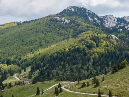
- Velebit traverse, Northern Velebit and Paklenica National Parks: The route crosses Croatia’s largest mountain, including Vaganski vrh and Sveto brdo. Paklenica’s deep limestone gorges are a major landmark for hikers on this section.
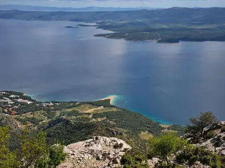
- Biokovo and Sveti Jure (1,762 m): Biokovo rises sharply above the Makarska Riviera, giving one of the trail’s most dramatic sea-to-mountain contrasts. The terrain is exposed and demanding in hot weather.
- Učka Nature Park: Učka is the forested mountain backbone of Istria above the Kvarner Gulf. It is one of the early high points after the Cape Kamenjak start.
- Risnjak National Park: This Gorski Kotar park is known for fir and beech forest and wildlife including lynx, bears and wolves. It adds a cooler, forested contrast to the exposed karst ridges.
- Konavle and Cape Oštro finish: The final approach crosses Snježnica above Konavle before reaching the Prevlaka peninsula near Montenegro. For easier coastal walking nearby, see the Dubrovnik to Cavtat Coastal Trail.
Challenges to expect
The main challenges are length, heat, water and rough limestone terrain. More than half the route uses marked Croatian mountain trails, but Via Adriatica is a linked network rather than a single purpose-built path, so navigation still matters. Exposed karst ridges can be very hot in summer, while Velebit and Dinara may hold snow into spring. Water can be scarce, so plan sources and carrying capacity carefully.
HikeList Score
Adriatic Long-Distance Trail scored 80/100 on HikeList's trail-quality metrics.
See score breakdownHide breakdown
- Ideal length 52
- Balanced challenge 84
- Scenery & wildness 82
- Varied terrain 100
- Accommodation 92
- Food & support 81
- Path quality 84
- Season flexibility 89
Computed from length, challenge, scenery & wildness, terrain variety, accommodation, food & support, path quality and season flexibility.
 Croatia
Show more data Show less
- Mountainous
- Coastal
- Karst
- Forest
- Gorges
- Rocky
- Gravel
- Forest Roads
- Paved
- Huts
- Shelters
- Cabins
- Guesthouses
- Apartments
- Pet Friendly
- Water Sources
- Campsites
- Shelters
Photos from hikers
Taken on the trail by people who've reviewed Adriatic Long-Distance Trail.
Reviews
How would you rate Adriatic Long-Distance Trail?
Tap a star to start your review — you could be the first.