Michinoku Coastal Trail
How would you rate Michinoku Coastal Trail?
Tap a star to share your experience and help other hikers.
Michinoku Coastal Trail: Japan’s 1,025 km Tohoku Coast Hike
HikeList Score
Michinoku Coastal Trail scored 79/100 on HikeList's trail-quality metrics.
See score breakdownHide breakdown
- Ideal length 52
- Balanced challenge 80
- Scenery & wildness 98
- Varied terrain 71
- Accommodation 83
- Food & support 88
- Path quality 74
- Season flexibility 76
Computed from length, challenge, scenery & wildness, terrain variety, accommodation, food & support, path quality and season flexibility.
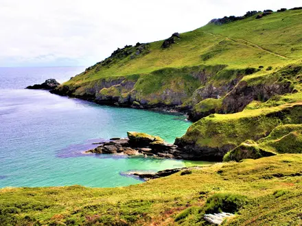
The Michinoku Coastal Trail is Japan’s longest long-distance hiking route: a 1,025 km waymarked coastal path along the Sanriku Coast in Tohoku, northern Honshu. A full thru-hike takes roughly 50 days and is hard because of the sustained distance, daily coastal climbs and descents, mixed surfaces and occasional patchy signage. It suits experienced multi-day walkers, while many hikers sample individual municipal sections over 1–3 days. The route passes through Sanriku Fukko (Reconstruction) National Park and links fishing towns, beaches, cliffs, forests and tsunami-recovery communities.
Route Overview
This is a point-to-point trail, commonly walked north to south from Kabushima Shrine in Hachinohe, Aomori Prefecture, to Matsukawaura in Soma, Fukushima Prefecture. The route follows the Pacific-facing Sanriku Coast through Aomori, Iwate, Miyagi and Fukushima, with key places including Tanesashi Coast, the Kitayamazaki cliffs near Tanohata, Jodogahama at Miyako, Goishi Coast near Ofunato and Kesennuma. It is divided into about 28 municipal sections, which makes it practical to walk in shorter blocks. Surfaces change often: beaches, grassy terraces, red pine forest paths, paved town sections, stone and log stairs, fishermen’s tunnels and a short boat segment in places. Detailed transport options are not specified in the verified brief.
A Reconstruction Trail for the Sanriku Coast
The Michinoku Coastal Trail was created as part of the Green Reconstruction Project after the 2011 Great East Japan Earthquake and tsunami. It was built section by section over several years, with the full 1,025 km route completed in June 2019. Managed by the Michinoku Trail Club, it runs through Sanriku Fukko (Reconstruction) National Park and is intended to connect walkers with the recovering coastal communities of the Sanriku region. National Geographic named it one of its Best Trips for 2020.
Notable highlights
- Kabushima Shrine, Hachinohe: The northern trailhead sits on a small island and is a major nesting ground for black-tailed gulls, known locally as umineko, between roughly March and August.
- Tanesashi Coast: A distinctive stretch of natural grassy meadows running down to the shoreline, and one of the best-loved sections of the route.
- Kitayamazaki cliffs, Tanohata: Around 200 m sheer cliffs, sea caves and unusual rock formations. The trail section through this area is both scenic and among the most demanding on the route.
- Jodogahama, Miyako: A Sanriku Coast signature spot known for white pebbles, cobalt-blue water and pale hexagonal rock formations.
- Goishi Coast, Ofunato: A roughly 6 km headland whose smooth dark-and-light pebbles resemble go game stones, giving the coast its name.
Challenges to expect
The difficulty is less about altitude and more about scale: 1,025 km of repeated coastal climbs, descents and changing surfaces. Expect sandy beaches, paved town walking, forest paths, mountain-trail sections, steep stone or log stairs and some patchy signage. Summer is hot, humid and wet, so spring and autumn are the preferred seasons. Accommodation is in towns and villages; there are no dedicated thru-hiker huts.
HikeList Score
Michinoku Coastal Trail scored 79/100 on HikeList's trail-quality metrics.
See score breakdownHide breakdown
- Ideal length 52
- Balanced challenge 80
- Scenery & wildness 98
- Varied terrain 71
- Accommodation 83
- Food & support 88
- Path quality 74
- Season flexibility 76
Computed from length, challenge, scenery & wildness, terrain variety, accommodation, food & support, path quality and season flexibility.
 Japan
JapanShow more data Show less
- Coastal
- Forest
- Mixed
- Sandy
- Paved
- Guesthouses
- Hotels
- Camping
- Family Friendly
- Pet Friendly
- Restrooms
- Water Sources
- Campsites
- Shelters
- Picnic Areas
In these collections
Photos from hikers
Taken on the trail by people who've reviewed Michinoku Coastal Trail.
Reviews
How would you rate Michinoku Coastal Trail?
Tap a star to start your review — you could be the first.