The seven-stage split below uses the common roughly 21 km-per-day itinerary from Mow Cop to Kinver Edge. Exact daily mileage can vary with accommodation detours, route variants and access choices, so check the current official guide, map or GPX before booking fixed transport.
Stage 1: Mow Cop to Rudyard Lake — approx. 21 km
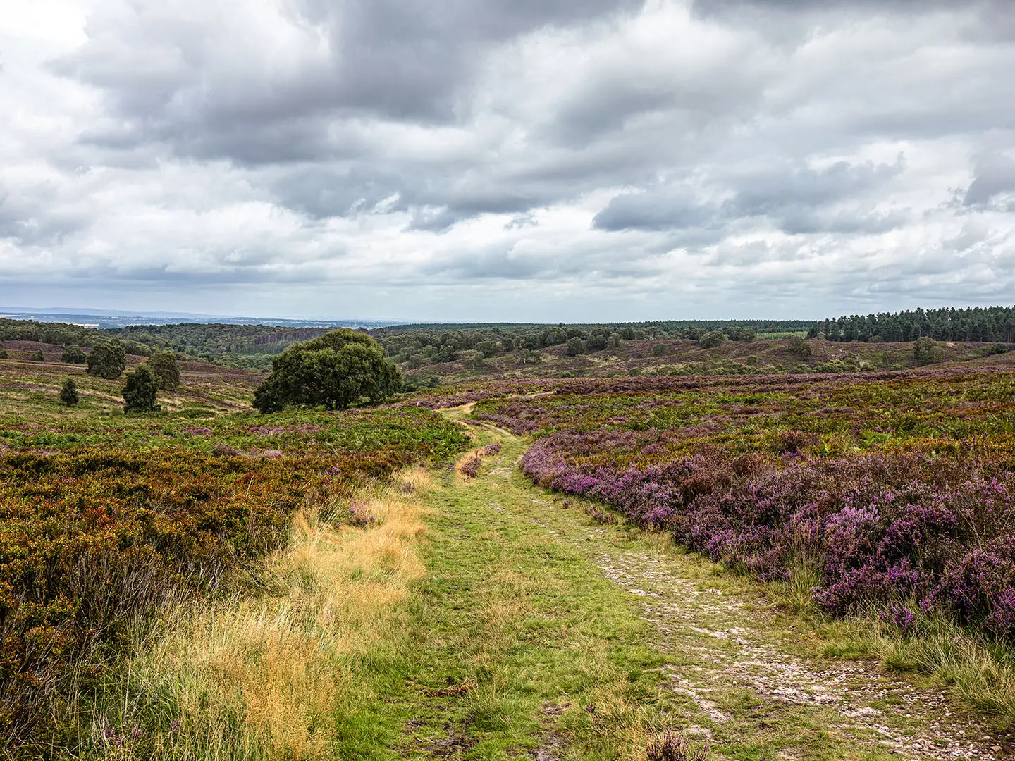
The opening stage is the highest and most exposed part of the Staffordshire Way, starting on the gritstone ridge at Mow Cop and crossing the Cheshire/Staffordshire border country towards Congleton Edge and The Cloud. It feels more like the edge of the Peak District than a lowland county trail, with open moorland, heather, gritstone outcrops and wide views before the route drops to easier railway paths and the western shore of Rudyard Lake.
Underfoot, expect a mixture of ridge paths, moorland tracks, disused railway lines and lakeside paths. The ridge walking is straightforward in good weather but can be wet and boggy after rain, especially around the higher gritstone ground near The Cloud. The ascent towards The Cloud is generally manageable from the south, but the descent eastwards is steep enough to need care in wet conditions. Later in the day, the Biddulph Valley Railway and the former Churnet Valley branch give flatter, better-drained walking.
Key landmarks come early. Mow Cop Castle is an 18th-century sham-ruin folly on a gritstone outcrop, with the Old Man of Mow quarry pillar nearby. The route then continues over Congleton Edge, through the Nick i’ the Hills dip and up over The Cloud, climbing directly to its 343 m trig point past the earthworks of an Iron Age hillfort, with broad views over Bosley Reservoir, the Dane Valley and the Cheshire Plain, before dropping steeply south-east towards the River Dane. After the descent, the Ravenscloud Brook ravine gives a more enclosed wooded section before the day finishes beside Rudyard Lake, a reservoir built to feed the Caldon Canal and later a Victorian resort.
Food and water are limited on this stage. There are no reliable shops between Mow Cop and Rushton Spencer, so carry lunch from the start. Rushton Spencer is the main useful midway stop, with The Knot Inn serving food; check current opening times before relying on it. Rudyard itself is small and has limited facilities, while Leek, around 2–3 km off-route, has supermarkets, cafés, pubs and fuller resupply options.
Accommodation is easiest to arrange in or near Leek rather than at Rudyard itself. Rudyard has some local options, but choice is limited and should be booked ahead. Many walkers use a taxi or short off-route transfer to Leek for B&Bs, guesthouses, hotels and pubs with rooms.
For access, Mow Cop has no railway station. Kidsgrove is the nearest rail option, about 3 km away by road, with onward taxi access commonly used from Kidsgrove or Stoke-on-Trent. Local buses serve the wider area, including route 95 and D&G Bus route 318 between Alsager, Kidsgrove and Congleton, but current timetables should be checked before travelling. Rudyard has no station; onward travel usually means Leek Bus Station, Macclesfield or a local taxi.
Navigation is generally uncomplicated on this first day. The Stafford knot waymarks are useful from the start, the ridge paths are clear in good visibility and the disused railway lines are easy to follow. The main planning issue is weather rather than route-finding: the Mow Cop–The Cloud section is exposed, with little shelter in poor conditions.
Stage 2: Rudyard to Hawksmoor — approx. 21 km
This stage links Rudyard Lake, the Caldon Canal and the wooded Churnet Valley, giving one of the most varied days on the route. It begins gently, following the canal feeder for several kilometres towards Leek and the Caldon Canal, before entering the steeper, more enclosed valley landscape around Cheddleton, Consall and Froghall.
The early canal and feeder sections are flat and simple, though towpaths can be muddy after rain. The character changes around Consall Forge, where the route climbs steeply from the canal towards Kingsley. This woodland climb gains height quickly and can be hard, slippery work in wet conditions. Higher up, the route uses field paths and lanes around Kingsley and Kingsley Holt before descending again towards the River Churnet and Hawksmoor.
Cheddleton Flint Mill is one of the key features on the first half of the day, standing close to the canal where corn milling was later replaced by flint grinding. Consall Forge is the best-known stop on the stage, with the canal, River Churnet and Churnet Valley Railway all close together. The Black Lion at Consall Forge is the main pub stop and is reached across the canal and railway; check opening times before planning lunch around it. Froghall and the surrounding limekilns and industrial remains mark the lower Churnet Valley’s working past. The stage ends near Hawksmoor Nature Reserve, a National Trust woodland area of stunted oaks and semi-natural woodland.
There are few services after leaving Rudyard or Leek. The Black Lion is the only substantial midway food and drink stop on the line of the stage. Kingsley and Kingsley Holt should not be relied on for resupply. Carry enough food and water for the full day, particularly if walking outside normal pub hours.
Hawksmoor itself has no walker accommodation on-site. Overnight options are usually found in Oakamoor, Alton or elsewhere in the Churnet Valley, with some walkers returning by taxi to Leek. Choice is limited compared with larger towns, so this is a stage where accommodation should be arranged before setting out.
Public transport access at Hawksmoor is weak. There is no direct public transport to the Hawksmoor car park, and taxi pick-up is more practical from Oakamoor or Alton. The Churnet Valley Railway operates heritage services seasonally in the valley; this should be treated as a visitor railway rather than a dependable trail transport link unless the current timetable fits.
Navigation is easy along the canal but needs more attention on field paths between Kingsley and Kingsley Holt. In Hawksmoor Woods, National Trust paths are clearer, but woodland junctions still require care. The main warning is the steep, muddy climb away from Consall Forge after rain, plus the need to cross the canal and railway level crossing safely when visiting the Black Lion.
Stage 3: Hawksmoor to Uttoxeter — approx. 21 km
Stage 3 begins with some of the most secluded walking on the Staffordshire Way before gradually easing into farmland, river meadows and the market town of Uttoxeter. The first section through Sutton’s Wood, Stoney Dale, Ousal Dale and Dimmingsdale is steep-sided, wooded and enclosed, often considered the most atmospheric part of the Churnet Valley.
The terrain in the dales is more intricate than difficult: woodland paths, narrow valleys, short descents and path junctions where waymarks matter. After Alton, the route becomes gentler and more open. The line towards Rocester follows the historic Saltersford Lane area and a mix of field paths, minor tracks and rolling farmland. From Rocester to Uttoxeter, the walking flattens beside the River Dove, with some stretches briefly crossing into Derbyshire before the final approach over water meadows.
Alton Castle is visible from the valley, with its medieval origins and later Gothic Revival work by A.W.N. Pugin. Alton Towers lies about 2 km from the route and can be audible during its operating season, though it is not a trail facility. Toot Hill gives a useful viewpoint over the Churnet Valley. Denstone and Quixhill Bridge come before Rocester, where Richard Arkwright’s former cotton-spinning mill now forms part of the JCB Academy and the JCB headquarters campus is nearby. Near Uttoxeter, Dove Bridge is a notable medieval bridge with surviving 14th-century arches.
Food and water are limited until Rocester. Alton has pubs and limited village services, including The Talbot Inn, but opening times should be checked. Rocester is the most useful intermediate stop, with The Red Lion serving as a practical lunch stop. Uttoxeter is the first major service town on the Staffordshire Way, with supermarkets, cafés, pubs, accommodation, buses and a railway station.
Uttoxeter is the best overnight stop for this stage. It has B&Bs, guesthouses and small hotels, as well as enough shops to make it the most useful full resupply point since Leek. Book ahead during busy local event periods, especially around the racecourse.
Uttoxeter station on Station Road has East Midlands Railway services towards Stoke-on-Trent and Derby, with step-free access. The station itself has limited amenities, so use the town centre for food and supplies. Bus services and taxis also make Uttoxeter a practical place to join or leave the trail.
Navigation needs attention in Ousal Dale and Dimmingsdale, where turns can be missed among woodland paths and gorge-side tracks. A notable angled turn into Ousal Dale is a point to check carefully. Near Uttoxeter, the route passes under the A50 dual carriageway; the underpass is part of the route but marks a shift from rural walking to the town approach. Expect some duller, wetter field walking in poor weather after the Churnet Valley highlights.
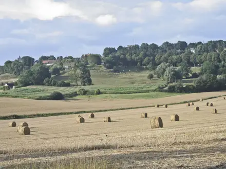
Stage 4: Uttoxeter to Shugborough — approx. 21 km
This is one of the flatter and easier days underfoot, but it is still a full-length stage and can feel long in wet farmland conditions. The route leaves Uttoxeter by Timber Lane and field paths, crosses the Bagot Park area, passes close to Blithfield Reservoir and Abbots Bromley, then uses the Trent & Mersey Canal towpath towards Shugborough.
The terrain is mostly low-level: green lanes, field paths, farmland, reservoir-side country, village approaches and canal towpath. Field sections around Bagot Park and Blithfield can be muddy after prolonged rain, and some stiles may be awkward or poorly maintained. The canal section later in the day is straightforward and gives easier progress before the route enters the landscaped parkland of Shugborough Estate.
Bagot Park is part of the old Needwood Forest landscape and gives a more open, estate-like feel than the Churnet Valley stages. Blithfield Reservoir is the largest body of water in Staffordshire and a major visual marker on the day. Abbots Bromley is the key settlement, known for its listed buildings and the ancient Horn Dance in September. The Goats Head Inn and the Crown are useful pub options in the village; check opening times before planning a stop. Beyond Colton, the Trent & Mersey Canal leads towards Great Haywood, Colwich Lock and the Shugborough area. Essex Bridge, a 16th-century packhorse bridge over the Trent, is one of the most distinctive structures near the end of the stage.
Abbots Bromley is the main food and water stop, with pubs and village services. Colton has very limited facilities and should not be relied on without checking first. Great Haywood, beside Shugborough, has some services, including the Clifford Arms, while Little Haywood also has limited options.
There is no normal walker accommodation on Shugborough Estate itself. Great Haywood, Little Haywood and Milford are the closest practical overnight areas, but availability is limited. Stafford, around 8 km to the west by bus or taxi, has a much wider choice of hotels and B&Bs and is often the more flexible base.
For transport, the Shugborough area is served indirectly. Rugeley Town and Rugeley Trent Valley stations lie around 3–4 km east of Shugborough, with rail connections towards Birmingham and Stoke. Stafford station to the west is a larger hub with intercity services. Current bus and rail timetables should be checked before relying on them, especially for evening connections.
Navigation is simple on the canal towpath and through Shugborough’s maintained estate paths. More care is needed on the farmland and Bagot Park sections, where waymarks and field exits can be less obvious, particularly in poor visibility or after path growth in summer. The main warnings are mud, exposed field walking in bad weather and the need to keep to public rights of way through estate land. Walking the Staffordshire Way as a public right of way through Shugborough does not require National Trust admission.
Stage 5: Shugborough to Penkridge — approx. 21 km
Stage 5 is the Cannock Chase day: a clear change from canals and farmland into heath, birch woodland and broader forest tracks. After the parkland of Shugborough and the Milford area, the route climbs into Cannock Chase, a National Landscape and one of the wilder-feeling sections of the Staffordshire Way, before crossing Bednall, Teddesley Park and the Staffordshire & Worcestershire Canal into Penkridge.
The Chase gives varied walking on sandy and gravelly tracks, heathland paths, woodland trails and valley descents, including the Sherbrook Valley. Compared with the very flat previous stage, this section has more contour and interest, though it is still moderate rather than mountainous. After leaving the Chase, the route becomes more agricultural again, passing through Bednall and historic parkland at Teddesley before finishing on canal towpath into Penkridge.
Key features include Harts Hill, the silver-birch heath of Cannock Chase, viewpoints across the open heath and the Sherbrook Valley. Wildlife is a major part of this stage: fallow deer are common on the Chase, along with woodland birds and other mammals. A glacial erratic boulder on a plinth marks the area’s Ice Age history. Bednall is a small village with a 19th-century church and useful churchyard benches. Teddesley Park gives mature trees and parkland associated with the former Teddesley Hall estate. The final canal section leads into Penkridge, a small market town with canal-side services.
Services are limited between Milford and Penkridge. Milford has some facilities just before the Chase, but there are no shops or pubs on the Chase proper. Carry food and water for the heath and woodland section. Bednall should not be relied on for supplies. Penkridge has shops, cafés and pubs, including The Boat Inn by the canal, making it a good end-of-day resupply stop.
Accommodation in Penkridge exists but is limited, so book ahead. Stafford, about 6 km north by rail, has a wider choice of hotels and B&Bs. Wolverhampton, around 14 km south by rail, is another practical accommodation fallback with city-centre options.
Penkridge station is on the Rugeley–Stafford–Wolverhampton line, with West Midlands Railway services useful for stage walking or reaching accommodation off-route. Road access is also strong, with the M6 running along the eastern side of Penkridge near Junctions 12 and 13. Rail and taxi times should be checked before committing to evening plans.
Navigation on Cannock Chase is helped by multiple trail markers, but the density of paths means it is important to stay with the Stafford knot waymarks rather than simply following the broadest track. Around Oldacre Valley, map lines and walked paths can be confusing, so a reliable GPX or OS map is useful. Teddesley Park and the canal approach are more straightforward. Dogs should be kept under close control around deer and livestock, and the Chase section should be treated as food-free for planning purposes.
Stage 6: Penkridge to Seisdon — approx. 21 km
This southern stage moves through parkland Staffordshire: field paths, green lanes, minor roads and estate landscapes around Brewood, Chillington Hall, Weston Park and Codsall. It is less dramatic than Cannock Chase or Kinver Edge, but it needs careful planning because services and accommodation do not always sit directly on the line of the trail.
From Penkridge, the route leaves the canal and turns south through farmland and lanes. Brewood lies close to the route rather than directly on it and is worth the short detour for food and supplies. The Staffordshire Way then crosses the Chillington Hall estate on public footpaths, passing through a landscape shaped by long estate ownership and Capability Brown parkland. It later skirts the Weston Park deer park area before continuing towards Codsall and then Seisdon.
Brewood is the most useful early highlight and service stop: a Georgian market town with shops, pubs and cafés just off-route. Chillington Hall is a Grade I listed mansion associated with the Giffard family since the 12th century; the route uses public rights of way through the estate, so walkers should not assume access beyond the path. Weston Park is another major estate on the Shropshire/Staffordshire border, with house and grounds open seasonally to visitors. Codsall is the main settlement later in the day, with shops, cafés, a Co-op nearby and the Codsall Station pub beside the railway station.
Food and water are best planned around Brewood and Codsall. Perton is passed nearby but not directly as a dependable trail stop. Seisdon is a small village with limited services, and any pub or shop opening should be checked before relying on it. Carry enough supplies to finish the day from Codsall if necessary.
Accommodation at Seisdon is very limited. Wolverhampton, around 7 km east, has the widest choice and strong transport links. Bridgnorth, around 10 km west, is another possible accommodation base with B&Bs and hotels. If staying off-route, arrange taxis in advance rather than expecting easy late-day options in Seisdon.
Codsall station, on the Wolverhampton–Shrewsbury line, is the key rail access point on the stage; current operators and timetables should be checked before travelling. Wolverhampton is the nearest major rail hub, with broader onward connections.
Navigation can be more demanding here than the terrain suggests. Waymarking on some southern sections can be patchy, and field exits, estate paths and minor lanes require attention. Carry OS mapping or a reliable GPX rather than relying only on posts. Expect some minor road walking and take normal care with traffic on narrow lanes. Livestock fields are common, so dogs should be controlled and field gates left as found.
Stage 7: Seisdon to Kinver Edge — approx. 21 km
The final stage continues through west Staffordshire countryside before building to the sandstone finish on Kinver Edge. It passes through or near the Pattingham and Enville area, crosses heathland at Highgate Common and then rises onto the National Trust-owned escarpment at Kinver, where the Staffordshire Way meets the North Worcestershire Path near the southern end of the route.
The terrain is a mix of field paths, lanes, wooded sections, common land and the final sandstone heath ridge. The first part of the day is typical southern Staffordshire field-and-village walking, with intermittent road sections and navigation that can require care. Highgate Common introduces more open heathland before the final approach to Kinver Edge, where the landscape becomes much more distinctive: red sandstone, birch, heather and wide views.
Pattingham is the key village on the stage, with a pub and small services; opening times should be checked. The route then continues south near Enville before reaching Highgate Common. Kinver Edge is the clear highlight of the day and a strong finish to the whole walk, with heath-covered sandstone, the Iron Age hillfort of Kinver Camp and views south towards the Wyre Forest and Worcestershire. The Holy Austin Rock Houses, cut into the sandstone cliffs and inhabited until the 1960s, are a National Trust visitor attraction near the finish. The café and visitor facilities are seasonal, so do not rely on them outside advertised opening times.
Food and water options are limited before Kinver. Pattingham may provide a pub stop, but it should not be treated as guaranteed without checking. The National Trust café at Kinver Edge is useful when open, particularly from spring to autumn and during some school holiday periods, but carry enough food and drink to finish the stage independently. Kinver village, about 1 km from the Edge, has the best end-of-route services, with pubs, cafés, village shops, restaurants and limited accommodation.
Accommodation at Kinver is available but not extensive, so book ahead if finishing there. Stourbridge, around 8 km east, and Kidderminster, around 8 km south, offer wider accommodation choices and are practical fallback towns if Kinver is full or if onward transport is easier from a larger centre.
Kinver has no railway station. Stourbridge Junction and Stourbridge Town are the nearest rail options, with onward services towards Birmingham New Street, Wolverhampton and beyond. Bus 242 links Stourbridge and Kinver, with a journey of roughly 25 minutes, but the current timetable should be checked before arrival. Taxis from Kinver to Stourbridge Junction or Wolverhampton are also commonly the simplest finish-day option.
Navigation on this final stage should not be underestimated. Waymarking through the Pattingham and Enville area can be patchy, and the day is long enough that small errors matter. Use OS mapping or a reliable GPX, especially through field systems and lane junctions. Once on Kinver Edge, National Trust signage and the escarpment itself make the finish more obvious. Set off early enough to reach Kinver village before food, café or bus options become limited.