Staffordshire Way

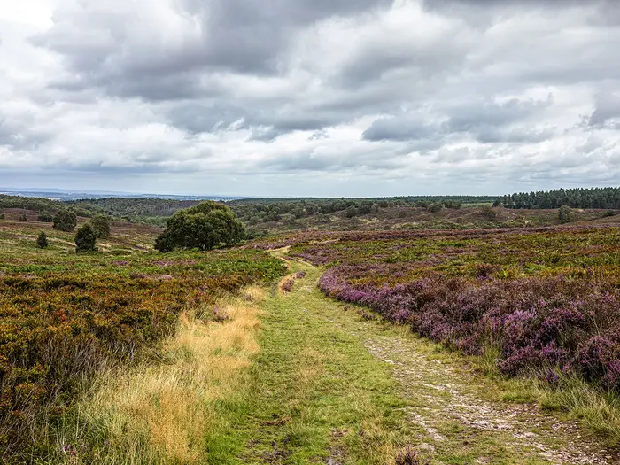
i Image by garry

1 hiker has reviewed this — add yours

Tap a star to share your experience and help other hikers.

Staffordshire Way: A Complete Hiking Guide

Published 17 July 2025 Updated 8 June 2026
1
Ranked #1 of 974
See the Top 100 →

HikeList Score

Staffordshire Way scored 96/100 on HikeList's trail-quality metrics.

96
Outstanding
See score breakdownHide breakdown
  • Ideal length 100
  • Balanced challenge 100
  • Scenery & wildness 98
  • Varied terrain 83
  • Accommodation 100
  • Food & support 88
  • Path quality 98
  • Season flexibility 89

Computed from length, challenge, scenery & wildness, terrain variety, accommodation, food & support, path quality and season flexibility.

The Staffordshire Way is a 148 km waymarked, point-to-point long-distance path through Staffordshire in England, usually walked north to south from Mow Cop to Kinver Edge in about 7 days. It is a moderate lowland hike: mostly field paths, woodland tracks, canal towpaths, parkland and gentle hills, with 2,195 m of total ascent. It suits hikers wanting a week-long county traverse with varied Midlands landscapes rather than high mountain terrain.

Route Overview

The route starts at Mow Cop Castle on the Cheshire/Staffordshire boundary, then follows the high gritstone ground around Congleton Edge and The Cloud before turning south-east through the county. Key places include Rudyard Lake, Leek, the Caldon Canal and Churnet Valley, Hawksmoor Wood, Rocester, Uttoxeter, the Trent and Mersey Canal, Shugborough Estate, Cannock Chase, Penkridge, Brewood, Weston Park, Codsall, Highgate Common and Kinver Edge. It is a linear walk, so plan separate start and finish logistics; no verified public transport details are included in the brief. For another Midlands canal-based walk, compare the Ashby Canal Trail; for a different inland English route, see the Amber Valley Route.

History of the Staffordshire Way

The Staffordshire Way was devised by Staffordshire County Council to run the length of the county and opened in three stages between 1977 and 1983. It was resurveyed and refurbished in 1995. The trail links with several other long-distance routes, including the Gritstone Trail, Limestone Way, Heart of England Way, North Worcestershire Path and Worcestershire Way. A 47.5-mile section also forms part of the European long-distance path E2.

Notable highlights

  • Mow Cop Castle: The northern trailhead is an 18th-century sham-ruin folly on a gritstone ridge straddling the Cheshire/Staffordshire border. It is also noted as the 1807 birthplace of Primitive Methodism.
  • Rudyard Lake: A two-mile reservoir near Leek, built to feed the Caldon Canal and later popular as a Victorian resort. It gives the route one of its clearest waterside sections.
  • Churnet Valley and Caldon Canal: The trail follows the Caldon Canal towpath through a wooded, steep-sided valley past Consall Nature Park and the Churnet Valley Railway.
  • Shugborough Estate: A grand 18th-century mansion and parkland estate now cared for by the National Trust. The Trent and Mersey Canal towpath takes the route past it.
  • Cannock Chase: A National Landscape of heath and woodland, known for lowland heath habitat and fallow deer. It is one of the wilder-feeling middle sections of the walk.
  • Kinver Edge: The southern finish is a heath-topped sandstone escarpment with an Iron Age hillfort and the Holy Austin rock houses, cut into the cliff and now cared for by the National Trust.

Challenges to expect

The difficulty is mainly cumulative: 148 km, 2,195 m of ascent and a full week on foot. Terrain is mostly low-level, but northern moorland can be exposed and boggy after rain, and woodland or field paths can be muddy. Waymarking uses the Stafford-knot logo, but some sections are poorly signed, so carry OS mapping. No permit is needed, though nearby attractions may charge admission or parking.

Distance
148 kilometres
Duration
7 days
Difficulty rating
Moderate
Trail type
Point to point
Elevation gain/loss
2195 metres
Highest point altitude
323 metres
When to hike
Best months: Mar–Nov
Climate: NASA POWER · location © OpenStreetMap
Show more data Show less
Permits & Fees
No permits or fees
Terrain & Landscape
  • Forest
  • Moorland
  • Wetlands
Trail surface
  • Dirt
  • Grass
  • Gravel
Accommodation
  • Hotels
  • Guesthouses
  • Campsites
  • Hostels
Average daytime temperature
15°C
Chance of rainfall
Medium
Estimated cost
$$
Optimal hiking season
Spring
March to May
Summer
June to August
Autumn
September to November
Accessibility
  • Family Friendly
  • Pet Friendly
Facilities
  • Restrooms
  • Water Sources
  • Campsites
  • Picnic Areas

Download Our Full Guide to Staffordshire Way FREE!

Get our comprehensive guide to this hike for free. Save it for later reading or print out at home.

Check out our library of free hiking guides

Report an issue

Spotted a mistake on Staffordshire Way? Tell us what's wrong and we'll fix it.

Hiker reviews

Written by HikeList users who have walked the trail — the most helpful first.

Adam★★☆☆☆
Difficulty: ModerateCompleted Took 6 days

First two days are worthwhile, but not the full route.

We walked the Staffordshire Way over six days in July. The first two days were excellent, but the final four felt like a chore. I therefore wouldn’t recommend the full route or walk it again. If you have a week, choose the Dales Way instead. The route does pass through varied terrain, and the Staffordshire countryside is stunning in summer. Our best day was the second, from Leek to Alton. Much of it followed canals lined with beautifully painted houseboats and weeping willows, before continuing through fields, forests and heathland full of wildlife. We saw herds of deer, birds of prey, English grass snakes and plenty of cattle. The day ended perfectly with our arrival in Alton beneath the medieval Alton Castle. It was genuinely idyllic. If you walk any part of the Staffordshire Way, do the first two days. The main problem was the condition of many paths through farmland. They appeared neglected and were badly overgrown with stinging nettles and thorny brambles. We would spend 30 enjoyable minutes crossing a few kilometres of beautiful rolling countryside, only to lose another 15 minutes forcing our way through 50 metres of sharp brambles and stinging nettles. This happened constantly and made each section feel anticlimactic. More walkers might help keep the paths clear, but the route seems extremely quiet. We didn’t meet a single other walker, and almost none of our accommodation hosts had even heard of the Staffordshire Way. After the high point of day two, the remaining four days felt underwhelming, and the finish at Kinver Edge was a major anticlimax. Our route was: Mow Cop – Leek – Alton – Rugeley – Penkridge – Tettenhall – Kinver Edge. We stayed in Stoke-on-Trent the night before and took an Uber to the start at Mow Cop. Tettenhall is some distance from the official route, so we took an Uber to our hotel and returned by Uber the following morning. From Kinver Edge, we took another Uber to Wolverhampton for the train home. If you’ve read this far, do the Dales Way instead lol.

Photos from hikers

Taken on the trail by people who've reviewed Staffordshire Way.

Staffordshire Way: The Complete Guide

Staffordshire Way i Image by garry

The Staffordshire Way is a full-county traverse from the gritstone fringe of the Peak District to the sandstone edge above Kinver, linking two very different ends of Staffordshire in 92 miles / 148 km.

It begins at Mow Cop Castle and crosses exposed northern ridge country over Congleton Edge and the 343 m summit of The Cloud. From there it softens through Rudyard Lake, Leek and the wooded Churnet Valley — the secluded "Staffordshire's Rhineland" of canal towpath, old industrial landscapes and steep valley sides.

Southwards it follows the Caldon and Trent & Mersey canals, passes the parkland of Shugborough, and opens onto the heath and forest of Cannock Chase. It then threads through the 18th-century estate country around Brewood, Codsall and Pattingham before finishing on Kinver Edge, with its heath-topped escarpment, hillfort and rock houses.

It suits reasonably fit walkers who want a varied, quieter Midlands journey rather than a mountain route, and it works just as well in day or section stages.

The walk asks for consistent mileage over about a week, separate start and finish logistics, and advance accommodation planning — there is no dedicated baggage-transfer operator or official booking scheme.

This guide covers practical stage planning, accommodation, food and water, transport to Mow Cop and from Kinver Edge, terrain and conditions, navigation, gear, budget, highlights, shorter sections and common mistakes.

Stage-by-Stage Guide

The seven-stage split below uses the common roughly 21 km-per-day itinerary from Mow Cop to Kinver Edge. Exact daily mileage can vary with accommodation detours, route variants and access choices, so check the current official guide, map or GPX before booking fixed transport.

Stage 1: Mow Cop to Rudyard Lake — approx. 21 km

The opening stage is the highest and most exposed part of the Staffordshire Way, starting on the gritstone ridge at Mow Cop and crossing the Cheshire/Staffordshire border country towards Congleton Edge and The Cloud. It feels more like the edge of the Peak District than a lowland county trail, with open moorland, heather, gritstone outcrops and wide views before the route drops to easier railway paths and the western shore of Rudyard Lake.

Underfoot, expect a mixture of ridge paths, moorland tracks, disused railway lines and lakeside paths. The ridge walking is straightforward in good weather but can be wet and boggy after rain, especially around the higher gritstone ground near The Cloud. The ascent towards The Cloud is generally manageable from the south, but the descent eastwards is steep enough to need care in wet conditions. Later in the day, the Biddulph Valley Railway and the former Churnet Valley branch give flatter, better-drained walking.

Key landmarks come early. Mow Cop Castle is an 18th-century sham-ruin folly on a gritstone outcrop, with the Old Man of Mow quarry pillar nearby. The route then continues over Congleton Edge, through the Nick i’ the Hills dip and up over The Cloud, climbing directly to its 343 m trig point past the earthworks of an Iron Age hillfort, with broad views over Bosley Reservoir, the Dane Valley and the Cheshire Plain, before dropping steeply south-east towards the River Dane. After the descent, the Ravenscloud Brook ravine gives a more enclosed wooded section before the day finishes beside Rudyard Lake, a reservoir built to feed the Caldon Canal and later a Victorian resort.

Food and water are limited on this stage. There are no reliable shops between Mow Cop and Rushton Spencer, so carry lunch from the start. Rushton Spencer is the main useful midway stop, with The Knot Inn serving food; check current opening times before relying on it. Rudyard itself is small and has limited facilities, while Leek, around 2–3 km off-route, has supermarkets, cafés, pubs and fuller resupply options.

Accommodation is easiest to arrange in or near Leek rather than at Rudyard itself. Rudyard has some local options, but choice is limited and should be booked ahead. Many walkers use a taxi or short off-route transfer to Leek for B&Bs, guesthouses, hotels and pubs with rooms.

For access, Mow Cop has no railway station. Kidsgrove is the nearest rail option, about 3 km away by road, with onward taxi access commonly used from Kidsgrove or Stoke-on-Trent. Local buses serve the wider area, including route 95 and D&G Bus route 318 between Alsager, Kidsgrove and Congleton, but current timetables should be checked before travelling. Rudyard has no station; onward travel usually means Leek Bus Station, Macclesfield or a local taxi.

Navigation is generally uncomplicated on this first day. The Stafford knot waymarks are useful from the start, the ridge paths are clear in good visibility and the disused railway lines are easy to follow. The main planning issue is weather rather than route-finding: the Mow Cop–The Cloud section is exposed, with little shelter in poor conditions.

Stage 2: Rudyard to Hawksmoor — approx. 21 km

This stage links Rudyard Lake, the Caldon Canal and the wooded Churnet Valley, giving one of the most varied days on the route. It begins gently, following the canal feeder for several kilometres towards Leek and the Caldon Canal, before entering the steeper, more enclosed valley landscape around Cheddleton, Consall and Froghall.

The early canal and feeder sections are flat and simple, though towpaths can be muddy after rain. The character changes around Consall Forge, where the route climbs steeply from the canal towards Kingsley. This woodland climb gains height quickly and can be hard, slippery work in wet conditions. Higher up, the route uses field paths and lanes around Kingsley and Kingsley Holt before descending again towards the River Churnet and Hawksmoor.

Cheddleton Flint Mill is one of the key features on the first half of the day, standing close to the canal where corn milling was later replaced by flint grinding. Consall Forge is the best-known stop on the stage, with the canal, River Churnet and Churnet Valley Railway all close together. The Black Lion at Consall Forge is the main pub stop and is reached across the canal and railway; check opening times before planning lunch around it. Froghall and the surrounding limekilns and industrial remains mark the lower Churnet Valley’s working past. The stage ends near Hawksmoor Nature Reserve, a National Trust woodland area of stunted oaks and semi-natural woodland.

There are few services after leaving Rudyard or Leek. The Black Lion is the only substantial midway food and drink stop on the line of the stage. Kingsley and Kingsley Holt should not be relied on for resupply. Carry enough food and water for the full day, particularly if walking outside normal pub hours.

Hawksmoor itself has no walker accommodation on-site. Overnight options are usually found in Oakamoor, Alton or elsewhere in the Churnet Valley, with some walkers returning by taxi to Leek. Choice is limited compared with larger towns, so this is a stage where accommodation should be arranged before setting out.

Public transport access at Hawksmoor is weak. There is no direct public transport to the Hawksmoor car park, and taxi pick-up is more practical from Oakamoor or Alton. The Churnet Valley Railway operates heritage services seasonally in the valley; this should be treated as a visitor railway rather than a dependable trail transport link unless the current timetable fits.

Navigation is easy along the canal but needs more attention on field paths between Kingsley and Kingsley Holt. In Hawksmoor Woods, National Trust paths are clearer, but woodland junctions still require care. The main warning is the steep, muddy climb away from Consall Forge after rain, plus the need to cross the canal and railway level crossing safely when visiting the Black Lion.

Stage 3: Hawksmoor to Uttoxeter — approx. 21 km

Stage 3 begins with some of the most secluded walking on the Staffordshire Way before gradually easing into farmland, river meadows and the market town of Uttoxeter. The first section through Sutton’s Wood, Stoney Dale, Ousal Dale and Dimmingsdale is steep-sided, wooded and enclosed, often considered the most atmospheric part of the Churnet Valley.

The terrain in the dales is more intricate than difficult: woodland paths, narrow valleys, short descents and path junctions where waymarks matter. After Alton, the route becomes gentler and more open. The line towards Rocester follows the historic Saltersford Lane area and a mix of field paths, minor tracks and rolling farmland. From Rocester to Uttoxeter, the walking flattens beside the River Dove, with some stretches briefly crossing into Derbyshire before the final approach over water meadows.

Alton Castle is visible from the valley, with its medieval origins and later Gothic Revival work by A.W.N. Pugin. Alton Towers lies about 2 km from the route and can be audible during its operating season, though it is not a trail facility. Toot Hill gives a useful viewpoint over the Churnet Valley. Denstone and Quixhill Bridge come before Rocester, where Richard Arkwright’s former cotton-spinning mill now forms part of the JCB Academy and the JCB headquarters campus is nearby. Near Uttoxeter, Dove Bridge is a notable medieval bridge with surviving 14th-century arches.

Food and water are limited until Rocester. Alton has pubs and limited village services, including The Talbot Inn, but opening times should be checked. Rocester is the most useful intermediate stop, with The Red Lion serving as a practical lunch stop. Uttoxeter is the first major service town on the Staffordshire Way, with supermarkets, cafés, pubs, accommodation, buses and a railway station.

Uttoxeter is the best overnight stop for this stage. It has B&Bs, guesthouses and small hotels, as well as enough shops to make it the most useful full resupply point since Leek. Book ahead during busy local event periods, especially around the racecourse.

Uttoxeter station on Station Road has East Midlands Railway services towards Stoke-on-Trent and Derby, with step-free access. The station itself has limited amenities, so use the town centre for food and supplies. Bus services and taxis also make Uttoxeter a practical place to join or leave the trail.

Navigation needs attention in Ousal Dale and Dimmingsdale, where turns can be missed among woodland paths and gorge-side tracks. A notable angled turn into Ousal Dale is a point to check carefully. Near Uttoxeter, the route passes under the A50 dual carriageway; the underpass is part of the route but marks a shift from rural walking to the town approach. Expect some duller, wetter field walking in poor weather after the Churnet Valley highlights.

Stage 4: Uttoxeter to Shugborough — approx. 21 km

This is one of the flatter and easier days underfoot, but it is still a full-length stage and can feel long in wet farmland conditions. The route leaves Uttoxeter by Timber Lane and field paths, crosses the Bagot Park area, passes close to Blithfield Reservoir and Abbots Bromley, then uses the Trent & Mersey Canal towpath towards Shugborough.

The terrain is mostly low-level: green lanes, field paths, farmland, reservoir-side country, village approaches and canal towpath. Field sections around Bagot Park and Blithfield can be muddy after prolonged rain, and some stiles may be awkward or poorly maintained. The canal section later in the day is straightforward and gives easier progress before the route enters the landscaped parkland of Shugborough Estate.

Bagot Park is part of the old Needwood Forest landscape and gives a more open, estate-like feel than the Churnet Valley stages. Blithfield Reservoir is the largest body of water in Staffordshire and a major visual marker on the day. Abbots Bromley is the key settlement, known for its listed buildings and the ancient Horn Dance in September. The Goats Head Inn and the Crown are useful pub options in the village; check opening times before planning a stop. Beyond Colton, the Trent & Mersey Canal leads towards Great Haywood, Colwich Lock and the Shugborough area. Essex Bridge, a 16th-century packhorse bridge over the Trent, is one of the most distinctive structures near the end of the stage.

Abbots Bromley is the main food and water stop, with pubs and village services. Colton has very limited facilities and should not be relied on without checking first. Great Haywood, beside Shugborough, has some services, including the Clifford Arms, while Little Haywood also has limited options.

There is no normal walker accommodation on Shugborough Estate itself. Great Haywood, Little Haywood and Milford are the closest practical overnight areas, but availability is limited. Stafford, around 8 km to the west by bus or taxi, has a much wider choice of hotels and B&Bs and is often the more flexible base.

For transport, the Shugborough area is served indirectly. Rugeley Town and Rugeley Trent Valley stations lie around 3–4 km east of Shugborough, with rail connections towards Birmingham and Stoke. Stafford station to the west is a larger hub with intercity services. Current bus and rail timetables should be checked before relying on them, especially for evening connections.

Navigation is simple on the canal towpath and through Shugborough’s maintained estate paths. More care is needed on the farmland and Bagot Park sections, where waymarks and field exits can be less obvious, particularly in poor visibility or after path growth in summer. The main warnings are mud, exposed field walking in bad weather and the need to keep to public rights of way through estate land. Walking the Staffordshire Way as a public right of way through Shugborough does not require National Trust admission.

Stage 5: Shugborough to Penkridge — approx. 21 km

Stage 5 is the Cannock Chase day: a clear change from canals and farmland into heath, birch woodland and broader forest tracks. After the parkland of Shugborough and the Milford area, the route climbs into Cannock Chase, a National Landscape and one of the wilder-feeling sections of the Staffordshire Way, before crossing Bednall, Teddesley Park and the Staffordshire & Worcestershire Canal into Penkridge.

The Chase gives varied walking on sandy and gravelly tracks, heathland paths, woodland trails and valley descents, including the Sherbrook Valley. Compared with the very flat previous stage, this section has more contour and interest, though it is still moderate rather than mountainous. After leaving the Chase, the route becomes more agricultural again, passing through Bednall and historic parkland at Teddesley before finishing on canal towpath into Penkridge.

Key features include Harts Hill, the silver-birch heath of Cannock Chase, viewpoints across the open heath and the Sherbrook Valley. Wildlife is a major part of this stage: fallow deer are common on the Chase, along with woodland birds and other mammals. A glacial erratic boulder on a plinth marks the area’s Ice Age history. Bednall is a small village with a 19th-century church and useful churchyard benches. Teddesley Park gives mature trees and parkland associated with the former Teddesley Hall estate. The final canal section leads into Penkridge, a small market town with canal-side services.

Services are limited between Milford and Penkridge. Milford has some facilities just before the Chase, but there are no shops or pubs on the Chase proper. Carry food and water for the heath and woodland section. Bednall should not be relied on for supplies. Penkridge has shops, cafés and pubs, including The Boat Inn by the canal, making it a good end-of-day resupply stop.

Accommodation in Penkridge exists but is limited, so book ahead. Stafford, about 6 km north by rail, has a wider choice of hotels and B&Bs. Wolverhampton, around 14 km south by rail, is another practical accommodation fallback with city-centre options.

Penkridge station is on the Rugeley–Stafford–Wolverhampton line, with West Midlands Railway services useful for stage walking or reaching accommodation off-route. Road access is also strong, with the M6 running along the eastern side of Penkridge near Junctions 12 and 13. Rail and taxi times should be checked before committing to evening plans.

Navigation on Cannock Chase is helped by multiple trail markers, but the density of paths means it is important to stay with the Stafford knot waymarks rather than simply following the broadest track. Around Oldacre Valley, map lines and walked paths can be confusing, so a reliable GPX or OS map is useful. Teddesley Park and the canal approach are more straightforward. Dogs should be kept under close control around deer and livestock, and the Chase section should be treated as food-free for planning purposes.

Stage 6: Penkridge to Seisdon — approx. 21 km

This southern stage moves through parkland Staffordshire: field paths, green lanes, minor roads and estate landscapes around Brewood, Chillington Hall, Weston Park and Codsall. It is less dramatic than Cannock Chase or Kinver Edge, but it needs careful planning because services and accommodation do not always sit directly on the line of the trail.

From Penkridge, the route leaves the canal and turns south through farmland and lanes. Brewood lies close to the route rather than directly on it and is worth the short detour for food and supplies. The Staffordshire Way then crosses the Chillington Hall estate on public footpaths, passing through a landscape shaped by long estate ownership and Capability Brown parkland. It later skirts the Weston Park deer park area before continuing towards Codsall and then Seisdon.

Brewood is the most useful early highlight and service stop: a Georgian market town with shops, pubs and cafés just off-route. Chillington Hall is a Grade I listed mansion associated with the Giffard family since the 12th century; the route uses public rights of way through the estate, so walkers should not assume access beyond the path. Weston Park is another major estate on the Shropshire/Staffordshire border, with house and grounds open seasonally to visitors. Codsall is the main settlement later in the day, with shops, cafés, a Co-op nearby and the Codsall Station pub beside the railway station.

Food and water are best planned around Brewood and Codsall. Perton is passed nearby but not directly as a dependable trail stop. Seisdon is a small village with limited services, and any pub or shop opening should be checked before relying on it. Carry enough supplies to finish the day from Codsall if necessary.

Accommodation at Seisdon is very limited. Wolverhampton, around 7 km east, has the widest choice and strong transport links. Bridgnorth, around 10 km west, is another possible accommodation base with B&Bs and hotels. If staying off-route, arrange taxis in advance rather than expecting easy late-day options in Seisdon.

Codsall station, on the Wolverhampton–Shrewsbury line, is the key rail access point on the stage; current operators and timetables should be checked before travelling. Wolverhampton is the nearest major rail hub, with broader onward connections.

Navigation can be more demanding here than the terrain suggests. Waymarking on some southern sections can be patchy, and field exits, estate paths and minor lanes require attention. Carry OS mapping or a reliable GPX rather than relying only on posts. Expect some minor road walking and take normal care with traffic on narrow lanes. Livestock fields are common, so dogs should be controlled and field gates left as found.

Stage 7: Seisdon to Kinver Edge — approx. 21 km

The final stage continues through west Staffordshire countryside before building to the sandstone finish on Kinver Edge. It passes through or near the Pattingham and Enville area, crosses heathland at Highgate Common and then rises onto the National Trust-owned escarpment at Kinver, where the Staffordshire Way meets the North Worcestershire Path near the southern end of the route.

The terrain is a mix of field paths, lanes, wooded sections, common land and the final sandstone heath ridge. The first part of the day is typical southern Staffordshire field-and-village walking, with intermittent road sections and navigation that can require care. Highgate Common introduces more open heathland before the final approach to Kinver Edge, where the landscape becomes much more distinctive: red sandstone, birch, heather and wide views.

Pattingham is the key village on the stage, with a pub and small services; opening times should be checked. The route then continues south near Enville before reaching Highgate Common. Kinver Edge is the clear highlight of the day and a strong finish to the whole walk, with heath-covered sandstone, the Iron Age hillfort of Kinver Camp and views south towards the Wyre Forest and Worcestershire. The Holy Austin Rock Houses, cut into the sandstone cliffs and inhabited until the 1960s, are a National Trust visitor attraction near the finish. The café and visitor facilities are seasonal, so do not rely on them outside advertised opening times.

Food and water options are limited before Kinver. Pattingham may provide a pub stop, but it should not be treated as guaranteed without checking. The National Trust café at Kinver Edge is useful when open, particularly from spring to autumn and during some school holiday periods, but carry enough food and drink to finish the stage independently. Kinver village, about 1 km from the Edge, has the best end-of-route services, with pubs, cafés, village shops, restaurants and limited accommodation.

Accommodation at Kinver is available but not extensive, so book ahead if finishing there. Stourbridge, around 8 km east, and Kidderminster, around 8 km south, offer wider accommodation choices and are practical fallback towns if Kinver is full or if onward transport is easier from a larger centre.

Kinver has no railway station. Stourbridge Junction and Stourbridge Town are the nearest rail options, with onward services towards Birmingham New Street, Wolverhampton and beyond. Bus 242 links Stourbridge and Kinver, with a journey of roughly 25 minutes, but the current timetable should be checked before arrival. Taxis from Kinver to Stourbridge Junction or Wolverhampton are also commonly the simplest finish-day option.

Navigation on this final stage should not be underestimated. Waymarking through the Pattingham and Enville area can be patchy, and the day is long enough that small errors matter. Use OS mapping or a reliable GPX, especially through field systems and lane junctions. Once on Kinver Edge, National Trust signage and the escarpment itself make the finish more obvious. Set off early enough to reach Kinver village before food, café or bus options become limited.

Planning the Route

How many days to allow

Most walkers should plan the Staffordshire Way as a 7-day walk. That gives a steady rhythm of roughly 21 km / 13 miles per day, which suits the terrain and lines up reasonably well with the towns and villages where accommodation is most likely.

A 6-day itinerary is possible for fit, experienced walkers who are comfortable with longer days and limited flexibility around accommodation. An 8-day itinerary is often more practical if you want shorter days, time at Shugborough Estate or Cannock Chase, or if available beds force a less even split.

The route is not technically hard for most of its length. The main planning issue is not mountain terrain, but the cumulative effect of a full week on field paths, woodland tracks, towpaths and muddy rural rights of way. The northern gritstone section around Mow Cop, Congleton Edge and The Cloud is the part that needs the most hill-walking judgement, especially in poor weather or after prolonged rain.

A practical 7-day structure

The neatest plan is to use the common 7-stage split, with each day built around an overnight stop or a nearby town with accommodation. Exact daily distances should be checked against the current Staffordshire County Council guide booklet or your chosen mapping app before booking, as route variants and accommodation detours can change the day length.

Day Stage Approx. distance Planning notes
1 Mow Cop to Rudyard Lake 21 km The most exposed northern day, crossing gritstone country near Congleton Edge and The Cloud before dropping towards Rudyard. Leek is the obvious larger accommodation base nearby, but may require a short detour or transport arrangement.
2 Rudyard to Hawksmoor / Churnet Valley 21 km A more wooded and canal-linked stage through the Leek, Caldon Canal and Churnet Valley area. Plan food and accommodation carefully, as the best overnight option may not be exactly on the line of the path.
3 Hawksmoor to Uttoxeter 21 km A useful stage because Uttoxeter is one of the more practical overnight and transport points on the route.
4 Uttoxeter to Shugborough 21 km Ends around the Shugborough Estate / Stafford area. Shugborough itself is not a large accommodation centre, so many walkers will need to look nearby, including Stafford.
5 Shugborough via Cannock Chase to Penkridge 21 km A key middle section through Cannock Chase, where navigation and water planning matter more than the modest height gain suggests. Penkridge is a useful overnight stop.
6 Penkridge to Seisdon 21 km Rural south Staffordshire walking, with accommodation becoming more limited than in the larger towns. Book ahead rather than assuming a bed will be available close to the path.
7 Seisdon to Kinver Edge 21 km Final approach through the southern estate and sandstone-edge country towards Kinver Edge. Kinver is a workable finish base, but accommodation is limited.

Some online stage plans use different overnight stops and can create much longer days, particularly in the southern half. Treat any stage over 30 km as a serious full day rather than a standard lowland walk, especially if carrying overnight kit.

Let accommodation shape the stages

Accommodation is the biggest constraint on the Staffordshire Way. There is no official accommodation booking scheme and no single trail-specific list covering the whole route. Stages are therefore usually shaped around towns and villages rather than around perfect walking distances.

The most useful planning bases include:

  • Leek — a practical market-town base near the northern stages, with B&Bs, pubs and more services than the smaller villages.
  • Uttoxeter — a strong mid-route stop with hotels and B&Bs.
  • Shugborough / Stafford area — useful for the end of the Uttoxeter stage; Stafford gives more accommodation choice than the estate area itself.
  • Penkridge — a convenient stop for the Cannock Chase and south Staffordshire section.
  • Brewood — an attractive village in the southern section, but with limited accommodation.
  • Kinver — useful for the final night or post-walk stay, though choice is limited.

Book earlier for weekends, school holidays and bank holidays. The rural stretch between Penkridge and Kinver Edge is the section where a neat on-route overnight plan is most likely to need adjustment, a taxi, or a short off-route detour.

Transport and linear-route logistics

The Staffordshire Way is a linear walk, and the start and finish do not form a simple public-transport loop. This needs deciding before accommodation is booked.

Common approaches are:

  1. Use public transport to reach the start and return from the finish. Kidsgrove is the nearest rail access point for Mow Cop, with Mow Cop about 3 miles away. A taxi or local bus connection may be needed for the final approach.
  2. Leave a car near the finish and travel to the start. This avoids a tired onward journey from Kinver Edge, but requires a reliable plan for reaching Mow Cop before the first stage.
  3. Arrange drop-off and collection. This is the simplest option where available, particularly because Kinver Edge is not directly linked to the start by one simple service.
  4. Use local taxis for awkward gaps. Taxis are often the most practical way to connect accommodation, trailheads and transport hubs on this route.

Useful access points for section hikers include Kidsgrove for Mow Cop, Uttoxeter for the middle of the route, Penkridge for the mid-to-southern section, and Stourbridge for Kinver Edge. Stourbridge is about 5 miles / 8 km from Kinver Edge, with bus links to Kinver, including the 242 service; current timetables should be checked before travelling.

There is no dedicated baggage-transfer operator marketed for the Staffordshire Way. Walkers should expect to carry their own kit or make ad-hoc arrangements with local taxi firms and accommodation providers.

Shortening, extending and section hiking

The Staffordshire Way is well suited to section hiking. It passes near several towns with rail or bus access, and many local walkers tackle it as a series of day walks rather than a continuous week.

Good break points include:

  • Mow Cop / Kidsgrove for the northern trailhead.
  • Leek / Rudyard / Churnet Valley for the northern and canal-valley stages.
  • Uttoxeter as a strong central access point.
  • Shugborough / Stafford area for the transition into Cannock Chase.
  • Penkridge for the southern half.
  • Kinver / Stourbridge for the finish.

To shorten the walk, use one of these access points to create a 2–4 day section rather than trying to force the whole route into too few days. To extend it, add time at Shugborough Estate, Cannock Chase, Leek or the Churnet Valley, or link the Staffordshire Way with nearby long-distance paths such as the Heart of England Way, North Worcestershire Path, Limestone Way, Cheshire Gritstone Trail or Worcestershire Way.

Navigation planning

The route is waymarked with the Stafford knot logo, but it should not be treated as a trail where signs alone are enough. Field paths, woodland junctions, towpaths and estate tracks create plenty of small decision points, and waymarking can be patchy in places.

Carry proper mapping and a backup navigation method. Useful Ordnance Survey sheets for the route include OL24, 218, 219, 242, 244, 258, 259 and 268. A GPX track is strongly recommended, especially for solo walkers, winter itineraries or anyone using off-route accommodation. The Staffordshire County Council guide booklet is the key official planning document.

A 2021 CPRE Staffordshire health-check identified waymarking failures and overgrown sections, so allow extra time for navigation rather than planning each day on walking speed alone.

Food, water and daily supplies

Do not assume every stage has regular services. The route passes through useful towns and villages, but several stretches of farmland, woodland, towpath and heath can leave you without shops or cafés for hours.

Plan each day around:

  • where breakfast is available;
  • where lunch can realistically be bought;
  • how much water is needed before the next reliable stop;
  • whether an evening meal is available at or near the overnight accommodation;
  • whether a short taxi or detour is needed to reach food.

Carry lunch and spare snacks unless the day’s services have been checked in advance. This is particularly important on rural southern stages and through Cannock Chase, where the walking is not remote in a mountain sense but services are not continuous along the path.

Weather, ground conditions and season

Spring, summer and autumn are the most practical seasons. The route is mostly low-level, but that does not make it immune to poor conditions. After rain, field paths, woodland tracks and northern moorland sections can become muddy or boggy, and progress can slow sharply.

The northern gritstone ground around Mow Cop, Congleton Edge and The Cloud is the most exposed part of the route. In mist, wind or winter conditions it needs more care than the rest of the walk. Cannock Chase and the southern sandstone/heath sections are lower, but still need sensible footwear and waterproofs in wet weather.

Permits, fees and access

No permit is required to walk the Staffordshire Way. It follows public rights of way and open-access-style visitor landscapes rather than a paid trail corridor. There is no charge simply to walk through Cannock Chase or to finish on Kinver Edge, although parking, visitor facilities or property entry charges may apply where relevant. Current opening arrangements and charges for specific attractions should be checked before travelling.

Towns, Villages and Overnight Stops

Accommodation on the Staffordshire Way is self-arranged. There is no official booking scheme and no dedicated baggage-transfer operator for this route, so most walkers either carry their own kit, use local taxis for selected transfers, or base themselves in larger towns and walk day sections.

For a continuous 6–8 day walk, the most useful overnight bases are generally Rudyard or Leek, Uttoxeter, the Great Haywood/Shugborough area, Penkridge, Brewood or Codsall, and Kinver. The awkward sections are the Churnet Valley/Hawksmoor area and Cannock Chase, where accommodation and food are more limited and should be planned before setting off.

Place Best use for walkers Accommodation picture Transport usefulness
Mow Cop Start logistics only No accommodation at the folly; use nearby towns Taxi or lift usually simplest
Rudyard / Leek First-night stop Rudyard has limited lakeside options; Leek has much more choice Leek has buses but no railway station
Uttoxeter Strong mid-route stop Good choice of hotels, B&Bs and food Railway station on the Crewe–Derby line
Great Haywood / Shugborough Useful Stage 4 area Campsites, B&Bs and cottages nearby; Stafford is the larger off-route base Stafford is the nearest larger transport hub
Penkridge Strong late-route stop Hotels, pub rooms, B&Bs and budget hotel options Railway station with useful West Midlands links
Brewood / Codsall Flexible late-stage stops Brewood has limited village accommodation; Codsall has services and rail Codsall is useful for joining/leaving late
Kinver Finish village Guesthouses, B&Bs and self-catering nearby No railway station; Stourbridge Junction is the practical rail link

Mow Cop

Mow Cop is the northern trailhead, with the Staffordshire Way starting at Mow Cop Castle, the gritstone sham-ruin folly on the Cheshire/Staffordshire border. It is an atmospheric place to begin, but it is a hilltop village rather than a full service centre.

There is a free car park below the castle, useful for drop-offs and day walkers. There is no overnight accommodation at the folly itself, so most walkers stay elsewhere the night before and travel in for the start. Congleton, around 4 km to the north, and Kidsgrove, around 5 km to the west, are the nearest practical towns for accommodation and onward transport.

Kidsgrove railway station is about 5 km away, on the Crewe–Derby and Manchester–Stoke lines. Some bus services run from Congleton, but for most end-to-end walkers a taxi from Kidsgrove or Congleton is the simplest start arrangement. Current public transport times should be checked before travelling.

Congleton Edge and The Cloud

The early route leaves Mow Cop for the gritstone border country around Congleton Edge and The Cloud. This is one of the more exposed northern sections and is not a service area. Do not plan on accommodation, shops or reliable food stops on the high ground itself.

Treat this part of the walk as a carry-through section: start with water, snacks and weather protection already sorted. The Way climbs over the 343 m summit of The Cloud itself, with a steep descent on the far side towards the River Dane, so allow time and care for the exposed, higher ground rather than expecting an easy passage.

Rushton Spencer

Rushton Spencer is a small rural village on the route, roughly between Mow Cop and Rudyard. It is a useful passing-through point rather than a major overnight base.

The Knot Inn gives the village a proper pub stop, and St Lawrence’s Church, often known as The Chapel in the Wilderness, is a notable local landmark. Facilities beyond this are limited, so do not rely on Rushton Spencer for a full resupply.

For day walkers, the Old Railway Station Car Park just off Station Lane, down a short lane between The Knot Inn and the Old Station, is a useful access point. Long-distance walkers should check current pub opening hours before counting on food here.

Rudyard and Rudyard Lake

Rudyard Lake is the natural first overnight area on many 7-day itineraries, after roughly the first 21 km from Mow Cop. The lake is a two-mile reservoir built to supply the Caldon Canal, and the route gives one of its clearest waterside sections here.

Accommodation at the lake is limited but useful. Hotel Rudyard has en-suite rooms, family cottages, a restaurant and a dog-friendly coffee shop; opening times and meal service should be checked before booking. Rudyard Lake Lodges offer self-catering lodge accommodation in woodland above the lake, better suited to walkers who are happy arranging a self-catered stay rather than a simple pub-room stop.

There is a lakeside café, but Rudyard is not a large service village and has no railway station. Local buses are limited. If Rudyard accommodation is full, Leek is only around 3 km south and is a much stronger overnight base, although reaching it may mean walking on or arranging a short taxi.

Leek

Leek is just off the route south of Rudyard Lake and is the best service town in the northern part of the Staffordshire Way. It is a practical overnight choice for walkers who want more accommodation, food and resupply options than Rudyard can offer.

Accommodation is much broader here, including a Premier Inn on Ashbourne Road, B&Bs, guesthouses, self-catering options and Roaches Bunkhouse for budget or group stays. This makes Leek a sensible first-night alternative, especially at weekends when lakeside accommodation may book out.

Food options are strong for a trail town. The Victorian Butter Market, outdoor market in Market Place, cafés, pubs, restaurants, takeaways and the Leek Oatcake Shop make it a good place to eat properly and restock snacks. Pubs range from old town-centre inns to more modern food-led options.

Leek has no railway station. Bus services connect it with the Stoke-on-Trent area, including services from Hanley and Stoke via Cheddleton, but timetables and fares should be checked before travelling. Walkers needing rail access usually connect by bus or taxi to Stoke-on-Trent, Congleton or Macclesfield.

Caldon Canal, Consall and Hawksmoor

The section through the Caldon Canal and Churnet Valley is one of the most distinctive parts of the route, but it is not one of the easiest for accommodation planning. The path follows canal towpath and wooded valley terrain through Consall Nature Park, with small settlements rather than service towns.

Consall Forge is a hamlet with an isolated canal-side feel. The Black Lion at Consall Forge is a memorable stop, reached by footpath, boat or the Churnet Valley Railway heritage line, but it should not be treated as a guaranteed food source without checking opening hours.

Hawksmoor, near Kingsley, is used as a Stage 2 endpoint in common itineraries, but it is very small and accommodation is limited. Walkers often need to plan carefully here: either secure a local bed in advance, arrange a taxi transfer, return to Leek, or continue towards better-served places on the Uttoxeter side. This is one of the key sections where booking late can create problems.

Rocester

Rocester is a small village on the River Dove, encountered before Uttoxeter on the southern half of the Churnet Valley to Uttoxeter stage. It works well as a food and rest stop, but it is not the main overnight target for most walkers.

The Red Lion is a useful village pub for Staffordshire Way walkers, and there are village stores on Ashbourne Road for groceries, snacks and basic supplies. Denstone Hall Farm Shop & Café is around 1.6 km from the village and can be useful if it fits the day’s timings.

Uttoxeter, around 3–4 km away, is the proper service town in this area. If accommodation in Rocester is limited or unavailable, continue to Uttoxeter or arrange transport there.

Uttoxeter

Uttoxeter is one of the strongest overnight stops on the Staffordshire Way and the first proper town with a broad range of services after the northern rural stages. It is a sensible place for a planned restock, a night indoors and a transport reset.

Accommodation includes the Bank House Hotel in the town centre, the White Hart Hotel, a Premier Inn and various B&Bs. Food options include pubs, cafés, restaurants, Market Square, Carters Square Shopping Centre and coffee/brunch stops such as BEAR Coffee Company.

Uttoxeter railway station is on the Crewe–Derby line, with services running between Crewe and Nottingham/Newark. This makes it the best mid-trail point for walkers who need to join, leave, pause, receive supplies or change plans. Current train times should still be checked before relying on a connection.

Trent & Mersey Canal, Great Haywood and Shugborough

After Uttoxeter, the route works towards the Trent & Mersey Canal and the Shugborough Estate. Great Haywood Junction, where canal and river routes meet near the estate, is the key planning area.

Great Haywood is a small canal village rather than a large service centre. Great Haywood Canalside Camping overlooks the canal junction and is within walking reach of the village and Shugborough Estate. Little Haywood has a pub and a small village shop. Other accommodation in the wider area includes B&Bs, holiday cottages and camping, including The White Lodge campsite between Shugborough Estate and the River Trent.

Shugborough Estate has National Trust facilities and a café, but opening is seasonal and should be checked before depending on it for food or toilets. Stafford, around 7 km west, is the nearest larger town with full accommodation, food and rail services, but using it as a base adds an off-route transfer.

Cannock Chase

Cannock Chase is a major landscape section rather than an overnight stop. The Staffordshire Way crosses heath and woodland within the National Landscape, and there are no towns in the Chase itself.

Carry enough water and food for the crossing, especially outside peak visitor hours. Birches Valley visitor centre, near Rugeley, has a café and facilities and can be a useful stop depending on the exact line being followed. Rugeley, east of the Chase boundary, is the fallback town for supplies if plans need changing.

Accommodation should be arranged before or after the Chase rather than assumed within it. This is a section where poor timing can leave a long walk to the next bed, particularly on Sundays or in bad weather.

Penkridge

Penkridge is one of the best late-route overnight stops. It is a large village or small town on the River Penk and the Staffordshire & Worcestershire Canal, with enough facilities to make it a comfortable break after the Cannock Chase stage.

Accommodation options include the Stafford South Hatherton Hotel, Travelodge Penkridge, local B&Bs and pub rooms. The Littleton Arms is a former coaching inn with modern hotel rooms and daily food, while The Boat Inn gives a canalside pub option. Penkridge also has independent shops, cafés, pubs and restaurants, plus a market on Wednesdays and Saturdays.

Penkridge railway station is a major practical advantage. Services run on the Birmingham New Street to Liverpool Lime Street route via Wolverhampton, with easy onward connections via Wolverhampton and Birmingham. This makes Penkridge the most useful mid-to-late trail access point for walkers joining, leaving or splitting the Staffordshire Way into sections.

Brewood

Brewood is an attractive market village and a good refreshment stop on the southern stages. It has shops, pubs, restaurants and tea rooms, making it useful for lunch, drinks and a slower village-based overnight if accommodation is available.

Pub options include The Bridge Inn on the Shropshire Union Canal, The Lion Hotel, The Swan Inn and The Oakley Arms on the village outskirts. The Bridge Inn is particularly useful for multi-day walkers because it has a coin-operated launderette as well as canal moorings.

Accommodation exists in and around Brewood, including B&B and guesthouse options, but capacity is more limited than in Penkridge. Many walkers therefore use Penkridge as the overnight base and treat Brewood as a daytime stop. There is no railway station in Brewood; the nearest rail options are Penkridge, around 7 km away, or Codsall, around 5 km away.

The southern route also passes through the estate landscapes around Chillington Hall and Weston Park. These should be treated as walking highlights rather than dependable resupply points unless current visitor facilities have been checked in advance.

Codsall

Codsall is a useful late-stage service village with a railway station, making it valuable for walkers who need to shorten, pause or rejoin the route near the southern end. It has everyday amenities including shops, pubs, restaurants, a GP, library and leisure centre.

Pub options include Codsall Station, a Grade II-listed conversion of the railway station with cask ales and railway memorabilia, plus The Bull, The Crown and The Cross Guns at Codsall Wood. Accommodation is not as central to Codsall’s role as transport and services, so walkers needing to sleep here should book ahead.

Codsall railway station is on the Wolverhampton–Shrewsbury line, with services to Wolverhampton and onward to Birmingham and the national rail network. It is one of the most practical late-route escape or access points.

Seisdon

Some 7-day itineraries use Seisdon as the break between Penkridge and Kinver Edge. Treat it as a route-planning point rather than a guaranteed service base.

Accommodation, food and public transport in or near Seisdon should be checked before travelling. If a suitable bed cannot be arranged, it may be more practical to plan around Penkridge, Brewood, Codsall or Kinver and use a local taxi transfer.

Pattingham and Highgate Common

Pattingham and Highgate Common fall on the southern approach towards Kinver Edge. The area is useful for route progression, but it should not be relied on in the same way as Penkridge, Codsall or Kinver for full walker services.

Plan food and water before leaving the better-served villages. If using accommodation or pub stops in this area, check availability and opening hours before travelling, especially on Sundays and bank holidays.

Kinver and Kinver Edge

Kinver is the practical finish village for the Staffordshire Way, sitting below Kinver Edge and its sandstone escarpment. The formal finish is on Kinver Edge, but the village is where walkers should look for food, accommodation and onward transport.

Kinver has a useful high street with cafés, tearooms, pubs, restaurants, independent shops, a fruit and veg shop and a butcher. Pubs include The White Hart, dating from the 14th century, and The Vine by the canal. Local accommodation includes guesthouses, B&Bs and self-catering cottages in and around the village.

Kinver Edge is managed by the National Trust and includes the Iron Age hillfort and the Holy Austin Rock Houses, cut into the sandstone. Opening times for the Rock Houses and visitor facilities should be checked if they are part of the finish-day plan.

Kinver has no railway station. The practical rail connection is Stourbridge Junction, about 6 km east, with services towards Birmingham New Street. Buses run towards Stourbridge, but a pre-booked taxi to Stourbridge Junction is the most reliable finish option, particularly after a late-afternoon arrival. Do not rely on last buses without checking current times.

Getting to the Start

The Staffordshire Way starts at Mow Cop Castle, a gritstone folly on the Cheshire/Staffordshire border at grid ref SJ 856573. Mow Cop is a hilltop village with no railway station of its own, sparse bus coverage and only short-stay parking at the castle, so the most practical start logistics are usually: train to Kidsgrove, then a short taxi to the trailhead.

By train

Kidsgrove is the nearest and most useful railway station for Mow Cop. It is about 3 miles / 4.5 km south-west of Mow Cop Castle, making it the best railhead for most walkers starting the Staffordshire Way.

Kidsgrove station is served by several regional services, including links from Stoke-on-Trent, Crewe, Manchester and the Derby/Nottingham direction. It has step-free access to all platforms and a station car park with 56 spaces, though current charges and parking conditions should be checked before relying on it for a multi-day walk.

Typical rail approaches include:

Starting point Practical rail route to Kidsgrove Notes
Manchester Piccadilly Direct train to Kidsgrove Around 47–50 minutes on the Manchester–Stoke service, then taxi to Mow Cop.
Stoke-on-Trent Train to Kidsgrove Very short journey, around 7–9 minutes, then taxi to the start.
Birmingham Train to Crewe, then change for Kidsgrove Allow roughly 1.5 hours overall, depending on connection times.
London Euston Train to Crewe, then change for Kidsgrove Around 2 hours or more overall, depending on connections.
Manchester Airport Train with a change, commonly via Crewe Journey times vary; allow around 1 hour 40 minutes to 2 hours 20 minutes, then taxi from Kidsgrove.

From Kidsgrove, a taxi to Mow Cop Castle is the normal final link. The drive is roughly 3 miles and takes about 10 minutes. Local taxi firms operate in the Kidsgrove and Mow Cop area, including firms based around Mow Cop Road, and taxis are commonly listed at the Kidsgrove station forecourt. Pre-booking is sensible, especially for an early start, Sunday travel or if arriving with a full pack.

Congleton station is a workable alternative, around 9 miles from Mow Cop. It has services towards Manchester and other regional destinations, but it is less convenient for the trailhead than Kidsgrove. From Congleton, a taxi is usually the practical option.

Train times, first and last services, engineering works and strike disruption should always be checked before travel.

By bus

Mow Cop has limited bus coverage and should not be treated as an easy bus-access trailhead.

The most relevant service is D&G Bus route 318, which links Alsager, Scholar Green, Kidsgrove, Mow Cop and Congleton and serves Mow Cop Post Office. However, this service is very limited, with operation only on certain weekdays, and it does not provide a reliable start option for most walkers. This should be checked before travelling.

There are also bus services in the wider Mow Cop and Biddulph area from the Stoke-on-Trent direction, including route 95, but routes and frequencies can change. This should be checked before travelling.

For most walkers using public transport, the realistic plan is:

  1. Travel by train to Kidsgrove.
  2. Take a pre-booked taxi to Mow Cop Castle.
  3. Start walking from the castle rather than trying to time the day around the sparse bus network.

Sunday and bank-holiday travel needs particular care. Bus options are reduced, and a taxi should be arranged in advance.

By car

Mow Cop is accessible by road from the A34 corridor between Newcastle-under-Lyme and Congleton, and from the M6, with junction 16 approximately 6 miles away. The village is on high ground, and the final approach roads are local roads rather than major trunk-road access.

There is a small National Trust car park on Mow Cop High Street / Castle Road for visitors to Mow Cop Castle, but it has a maximum stay of 2 hours. It is not suitable for leaving a vehicle while walking the Staffordshire Way.

For a linear, week-long walk, better car logistics include:

  • parking at or near Kidsgrove station, then taking a taxi to Mow Cop;
  • using paid long-stay car parks in Congleton town centre;
  • leaving a vehicle at the southern end near Kinver Edge and arranging transport back to the start;
  • using two vehicles for a self-arranged shuttle.

Current parking charges, maximum stays and overnight rules should be checked before travelling. Do not assume the Mow Cop Castle car park can be used for long-stay parking.

From the nearest airport

Manchester Airport is the most convenient international gateway for the start of the Staffordshire Way. It is about 24 miles north of Mow Cop. There is no direct train to Kidsgrove, so the usual public-transport route involves a change, commonly at Crewe, before continuing to Kidsgrove and taking a taxi to the trailhead. Journey times vary, but allow roughly 1 hour 40 minutes to over 2 hours by train plus the final taxi.

A direct taxi from Manchester Airport to Mow Cop is quicker but more expensive. The journey typically takes around 45–55 minutes and may cost roughly £40–60, depending on time of day, luggage and booking arrangements. Confirm current prices before booking.

Birmingham Airport is farther south, about 55 miles from Mow Cop, and is generally more useful for walkers dealing with the southern end of the route than for starting at Mow Cop. Rail travel to the Stoke-on-Trent or Kidsgrove area usually involves changes.

East Midlands Airport is also possible but less straightforward by rail, usually requiring a transfer to a rail hub before continuing towards Stoke, Crewe or Kidsgrove.

Where to stay before starting

Mow Cop itself is a small hilltop village with very limited accommodation, so most walkers stay nearby and take a taxi to the castle in the morning.

The most practical pre-walk bases are:

Base Why use it before starting?
Congleton Good choice if arriving from the Manchester side, with a reasonable selection of hotels and B&Bs and a rail station for onward travel.
Stoke-on-Trent / Kidsgrove Useful for the shortest morning transfer to Mow Cop, with wider accommodation choice in the Stoke area and quick rail access to Kidsgrove.
Alsager A smaller option on the A34 corridor, with some B&B and guesthouse accommodation.

Booking a night in Congleton or the Stoke-on-Trent/Kidsgrove area, then taking a morning taxi to Mow Cop Castle, is the simplest arrangement for most end-to-end walkers. Because the Staffordshire Way is linear and has no dedicated baggage-transfer operator or official accommodation-booking scheme, any luggage movement or taxi support should be arranged directly with local providers in advance.

Getting Home from the Finish

Kinver Edge is a practical but not railway-served finish. The Staffordshire Way ends on the sandstone ridge above Kinver, so most walkers first need to descend into Kinver village, roughly 1–2 km from the Edge, for buses, taxis, food and accommodation. The nearest main rail hub is Stourbridge Junction, about 10–12 km / 6–7 miles from Kinver.

By train

Kinver has no train station. The usual rail exit is via Stourbridge Junction, reached by bus or taxi from Kinver village.

From Stourbridge Junction there are regular services into Birmingham:

Rail link Typical use
Stourbridge Junction to Birmingham New Street Main onward hub for Avanti West Coast and CrossCountry services, including London Euston, Manchester, Bristol and Edinburgh. Journey time is typically about 29–43 minutes.
Stourbridge Junction to Birmingham Moor Street / Snow Hill Useful for Chiltern Railways services, including London Marylebone. Services are typically around every 30 minutes, with a journey time of about 26–29 minutes.
Stourbridge Town branch line Connects Stourbridge Junction with Stourbridge town centre and the bus interchange. This short shuttle is useful if changing between rail and local buses.

For London, the fastest options usually involve changing in Birmingham: New Street for London Euston, or Moor Street for London Marylebone. There is no direct train from Kinver, and Stourbridge-to-London journeys should be checked before booking, especially on Sundays or during engineering works.

By bus

The key public transport link from Kinver is Diamond Buses route 242, running between Kinver, Stourton, Wollaston and Stourbridge Bus Station / Stourbridge Interchange.

Important points for walkers:

  • The bus does not start from Kinver Edge itself; descend into Kinver village first.
  • Stops around Kinver village, including the clock tower area, are the practical place to pick up the service.
  • Journey time from Kinver to Stourbridge is about 24–25 minutes.
  • Weekday last buses from Kinver are around 18:40.
  • Saturday last buses are around 16:40, which is early for a long final walking day.
  • Sunday services are limited or may not run in a useful way for finishers.

Timetables change, so check Diamond Buses or Traveline before relying on the 242. This is especially important if finishing late, walking in winter daylight, or travelling on a Saturday, Sunday or bank holiday.

Stourbridge Interchange has useful facilities, including toilets during the day, but facilities may close early.

By car/taxi

Taxis are the most reliable fallback from Kinver, particularly if the last bus has gone or if carrying a full pack after the final descent from Kinver Edge.

Local options include:

  • Skyline Taxis Stourbridge — 01384 480 480
  • Crystal Cabs Stourbridge — 01384 422888 / Text4Taxi 07811 422888
  • Uber — operates in the area

A taxi from Kinver to Stourbridge Junction typically takes about 15–20 minutes. A taxi from Kinver to Birmingham city centre is usually about 45–60 minutes by road, depending on traffic. Pre-booking is sensible at weekends and if finishing late in the afternoon.

If being collected by car, the most useful finish-area parking points are:

  • National Trust car park, Compton Road, Kinver, DY7 6DL
  • Rocky Wall car park, Kingsford Lane, DY7 5NP

Both are near Kinver Edge. For longer stays in the village, Kinver Parish Council’s general car park is the relevant local parking option. Current parking rules and charges should be checked before leaving a vehicle.

For walkers who left a car at the start at Mow Cop, allow time for a multi-stage return. The practical pattern is usually taxi or bus from Kinver to Stourbridge Junction, then rail north towards the Stoke-on-Trent / Congleton area, with a final taxi for Mow Cop if needed. Kidsgrove is a few kilometres from Mow Cop and is on the Crewe–Stoke line, but exact rail connections and taxi availability should be checked before travelling.

There is no dedicated Staffordshire Way shuttle or baggage-transfer operator, so any private transfer between the start and finish needs to be arranged independently.

From the nearest airport

The nearest major airport is Birmingham Airport (BHX), around 30 miles / 48 km from Kinver by road.

Options from the finish are:

Option Practical notes
Taxi from Kinver or Stourbridge to Birmingham Airport Usually about 34–48 minutes by road, traffic-dependent. Typical airport-transfer fares are roughly £46–£84 depending on vehicle class and operator. Book ahead.
Rail via Stourbridge Junction and Birmingham New Street Take bus or taxi from Kinver to Stourbridge Junction, train to Birmingham New Street, then change for Birmingham International. Total journey time is typically about 50–70 minutes including the connection.

Birmingham International station is directly linked to the airport and has onward rail connections, including services towards London.

Where to stay at the finish

Staying in Kinver can be the easiest option if the final day runs late, especially on Saturdays when the 242 bus may finish around 16:40. It also avoids rushing the descent from Kinver Edge or relying on an evening taxi at short notice.

Kinver is a proper village finish with a High Street, pubs, cafés and shops. Accommodation in and near the village includes B&Bs and guesthouses such as The Laurels and White Cottage, with further options usually listed on mainstream booking platforms. Availability should be checked early for weekends.

Useful post-walk pub options in Kinver include The White Harte on the High Street, The Cat Inn near the foot of Kinver Edge, and The Plough and Harrow near the canal. Food service times should be checked if arriving after a long final stage.

Which Direction Should You Walk?

The Staffordshire Way is best walked north to south, from Mow Cop to Kinver Edge. This is the standard direction for the route, and it also makes the most practical sense for transport, terrain and the quality of the finish.

Standard direction: Mow Cop to Kinver Edge

Walking north to south starts with the most upland-feeling part of the route: Mow Cop Castle, the gritstone border country above Congleton Edge, and the exposed northern ground towards The Cloud. It then eases through Rudyard Lake, the Churnet Valley, canal towpaths, farmland, Shugborough, Cannock Chase and the southern parkland estates before finishing on the sandstone escarpment of Kinver Edge.

That progression works well. The first day feels like a proper high-start, while the final day still has a strong objective rather than simply fading out into lowland fields. Kinver Edge is one of the route’s best endpoints: a heath-topped ridge with wide views, an Iron Age hillfort and the Holy Austin rock houses nearby.

Transport: north to south is easier overall

This is the biggest practical reason to follow the standard direction.

Direction Start logistics Finish logistics Verdict
North to south: Mow Cop → Kinver Edge Mow Cop has no railway station, but Kidsgrove station is about 2.5 miles / 4 km away, so the trailhead is reachable by walking or taxi. Buses from Stoke-on-Trent also serve Mow Cop, but services should be checked before travelling. Kinver has no railway station, but bus 242 runs to Stourbridge Interchange on Monday to Saturday daytime services. Stourbridge Junction has frequent onward trains, including to Birmingham. A taxi from Kinver to Stourbridge is a useful fallback. Best option: the awkward end is dealt with at the start, while the finish has better onward travel.
South to north: Kinver Edge → Mow Cop Kinver can be reached via Stourbridge and the 242 bus, subject to current timetables. Finishing at Mow Cop leaves you on a hilltop with no station; most walkers would need to walk or arrange a taxi to Kidsgrove before catching a train. Less convenient, especially if finishing tired or late in the day.

For a north-to-south walk, many walkers make Kidsgrove the practical public-transport gateway to the start, then walk or take a local taxi up to Mow Cop Castle. At the southern end, Kinver village is a short walk from Kinver Edge, with the 242 bus to Stourbridge Interchange providing the main public-transport exit. Current timetables, last buses and Sunday services should be checked before booking travel; the 242 is not a Sunday fallback.

Terrain and climbing

The northern end contains the highest and roughest-feeling ground on the Staffordshire Way, with open gritstone edges and sometimes boggy moorland. Walking north to south puts this tougher terrain at the beginning of the route, when legs are fresh and packs are usually best organised.

After the northern section, the walking generally becomes lower and more varied: wooded valleys, canal towpaths, farmland, Cannock Chase heath and forest, and landscaped parkland. There is still cumulative distance to deal with, but the route does not save its most exposed gritstone walking for the final tired days.

Walking south to north reverses that pattern. It gives an easier lowland start, but it also means ending with the more exposed northern ridges and the awkward Mow Cop exit.

Weather and wind

Staffordshire’s prevailing winds are broadly south-westerly to westerly. Because the Staffordshire Way runs broadly north to south, walking north to south usually means the wind is more likely to be behind you or on your side than directly in your face, particularly on the open northern sections around Mow Cop and Congleton Edge.

This is not a decisive factor in settled summer weather, but it can matter in autumn, winter or any blustery spell. Walking south to north can make the exposed northern end feel harder if the prevailing wind is up.

Accommodation flow

There is no dedicated baggage-transfer service or official accommodation-booking scheme on the Staffordshire Way, so the direction needs to work with realistic overnight stops. The north-to-south flow fits the common accommodation pattern well, with useful overnight areas including Leek, Uttoxeter and Penkridge as the route progresses.

Reverse walking is possible, but it does not create a clear accommodation advantage. In either direction, beds should be booked around the main towns and villages, with some willingness to detour off-route or use local taxis where necessary.

Finish quality and psychology

A good long-distance walk benefits from a strong finish, and Kinver Edge provides one. The final sandstone ridge, heathland, views and rock houses make the southern end feel like a destination rather than just the end of a line on the map.

Mow Cop is also a memorable place, but as a finish it is less practical: it is more remote, has no railway station, and generally leaves extra onward travel after the walking is done.

Recommendation

Walk the Staffordshire Way north to south: Mow Cop to Kinver Edge. It is the standard direction, gives the better transport finish, starts with the toughest upland section while you are fresh, works naturally with the main overnight towns, and ends with one of the most distinctive landscapes on the route.

Accommodation Along the Route

The Staffordshire Way is workable as an inn-to-inn walk, but it is not a trail where accommodation falls neatly at every stage end. There is no official accommodation-booking scheme, no single trail accommodation list and no dedicated baggage-transfer operator, so overnight stops need to be planned individually. Most walkers build the itinerary around Leek or Rudyard, Uttoxeter, Penkridge, Brewood or nearby villages, and Kinver, with taxis used where the route finishes in a quieter rural section.

The main pinch point is the Churnet Valley / Hawksmoor end of Stage 2, where on-route beds are genuinely limited. Shugborough is the other awkward overnight because the estate itself is not an accommodation stop; Great Haywood or Rugeley are more practical. Book those two nights first, then fill the easier town stops around them.

Accommodation by place

Place Accommodation level (good/limited/none) Best for Notes
Mow Cop Limited Pre-walk night if starting early Accommodation is not the strength of the northern trailhead. Many walkers start after travelling in or stay nearby off-route. This should be checked before travelling.
Rudyard / Rudyard Lake Limited End of Stage 1 Hotel Rudyard is the most convenient named option at the lake end, with rooms and food. Book early if relying on it.
Leek Good Best northern accommodation hub Stronger choice than Rudyard, with chain, B&B and guesthouse options including Premier Inn Leek, The Green Man Guesthouse and The White Hart Tearoom. It may require a short road transfer or detour from Rudyard.
Blackshaw Moor / Upperhulme area Limited Walkers wanting a northern moorland-style stop Three Horseshoes Country Inn is a useful off-route inn near Leek. Roaches Bunkhouse near Upperhulme is a budget hostel-style option for walkers arranging a detour or alternative northern stop.
Consall / Hawksmoor / Churnet Valley Limited End of Stage 2 if booked well ahead This is the most awkward accommodation section. Options include Consall Valley Lodge for groups and Wildacres apartment in the Churnet Valley, but individual walker choice is limited. A taxi to Oakamoor, Cheadle or another nearby village may be needed.
Cheadle area Good Taxi-based overnight for the Churnet Valley A practical fallback for Stage 2, with B&B and guesthouse options and Hales Hall Caravan & Campsite on the edge of town for campers. Current transport should be checked before relying on buses.
Abbots Bromley area Limited Shortening Stage 3 before Uttoxeter Useful if splitting the Hawksmoor–Uttoxeter day. Antlers Bed and Breakfast and Marsh Farm B&B & Tea Room are examples in or near the village area.
Uttoxeter Good End of Stage 3 One of the strongest accommodation towns on the route, with B&Bs, small hotels and wider services. A sensible anchor for the middle of the walk.
Shugborough Estate None Daytime route highlight only The route passes the estate, but it is not an overnight accommodation stop. Plan for Great Haywood, Rugeley or a taxi transfer.
Great Haywood Limited End of Stage 4 near Shugborough A practical village stop just beyond Shugborough via the Trent & Mersey Canal, with some B&B-style accommodation. Book ahead.
Rugeley Good Shugborough / Cannock Chase access A useful nearby town for Stage 4 or before crossing Cannock Chase, with B&B and self-catering options. Blithfield Lakeside Barns is an off-route self-catering/group option near Rugeley.
Cannock Chase Limited Campers or walkers splitting the Chase section The Rag Country Inn at Rawnsley is a useful inn on the edge of the Chase. Camping options include Cannock Chase Camping and Caravanning Club Site, Tackeroo Camp Site and Chase Camping at Four Oaks Farm. Campsite seasons and membership requirements should be checked before booking.
Hednesford Good Budget fallback from Cannock Chase Travelodge Hednesford provides a budget chain option reachable from the Chase area by local transport or taxi. Current bus links should be checked before travelling.
Penkridge Good End of Stage 5 One of the best stage-end villages for accommodation. The village has a central 17th-century coaching inn with boutique en-suite rooms, plus other B&B-style choices nearby.
Brewood Good Stage 6 overnight A practical southern overnight base. The Staffordshire Grill & Lion Hotel has boutique bedrooms, and the village area has B&Bs and self-catering cottages.
Chillington Hall / Weston Park None Route landmarks only These estate sections are not casual overnight stops for walkers. Use Brewood, Codsall or nearby villages for accommodation.
Codsall Good Alternative to Brewood / southern logistics A practical nearby settlement for Stage 6 planning where Brewood is full or the day needs adjusting. Exact accommodation and transport should be checked before booking.
Seisdon Limited Stage-break area only The 7-day split often uses Seisdon as a practical stage division, but accommodation choice is limited. Many walkers are better served by Brewood, Codsall, Pattingham or a taxi transfer.
Pattingham Limited Alternative southern stop Useful for adjusting the final stages, but do not assume plentiful walker accommodation. Book ahead.
Kinver Limited Finish night Kinver has modest accommodation rather than a large hotel base. Dunsley Hall Hotel is the most substantial local option, and The Fox Inn offers a village pub-with-rooms option.
Stourbridge area Good Wider choice after finishing If Kinver is full or a wider choice of hotels and restaurants is wanted, Stourbridge is a practical taxi or bus option from the finish area. Current transport should be checked before travelling.

Best overnight stops for a 7-day itinerary

A typical 7-day accommodation plan uses the listed stage ends, but the strongest sleeping bases are not always exactly on the line of the path:

  • Night 1: Rudyard or Leek — Rudyard is most convenient if a room is available; Leek has the better overall choice.
  • Night 2: Hawksmoor / Churnet Valley / Cheadle area — the hardest night to arrange. Book this before committing to the rest of the itinerary.
  • Night 3: Uttoxeter — the easiest mid-route town for accommodation and services.
  • Night 4: Great Haywood or Rugeley — use these rather than expecting to sleep at Shugborough itself.
  • Night 5: Penkridge — a strong stage-end base after Cannock Chase.
  • Night 6: Brewood, Codsall, Pattingham or a taxi-based stop near Seisdon — Brewood is usually the most practical named base for this part of the route.
  • Night 7: Kinver or Stourbridge area — Kinver works for a quiet finish; Stourbridge gives more choice if Kinver’s limited accommodation is full.

Booking ahead and seasonal pressure

Advance booking is strongly advised rather than optional. The Staffordshire Way passes near enough towns to make accommodation possible, but several stage ends are rural and the best-located rooms can disappear quickly.

Prioritise bookings in this order:

  1. Churnet Valley / Hawksmoor / Cheadle area — the tightest supply on the route.
  2. Rudyard or Leek — especially for Friday or Saturday nights.
  3. Great Haywood / Rugeley — needed because Shugborough itself is not an overnight stop.
  4. Penkridge and Brewood — popular village bases with limited central rooms.
  5. Kinver — small finish village with fewer beds than a large town.

Summer weekends, bank holidays and Saturday nights throughout the year need particular care. July and August are the busiest months, but May, June and September can also be tight when weather is good. Many B&Bs and country inns operate year-round, while some campsites are seasonal, often running roughly spring to autumn; exact opening dates should be checked before travelling.

As a rough planning guide, simple B&B rooms often start around £50–65 per person per night, pub rooms and budget options around £40–55, and small hotels around £70–100+. Prices vary by season, room occupancy and weekend demand, so confirm current rates before booking.

Baggage transfer, taxis and camping

There is no dedicated Staffordshire Way luggage-transfer service comparable with those on the busiest National Trails. Walkers usually choose one of three approaches:

  • Carry everything and use B&Bs, inns or campsites.
  • Travel light and use local taxis to reach off-route accommodation at places such as Cheadle, Rugeley or Stourbridge.
  • Use private car support from a non-walking partner or a self-arranged shuttle plan.

Taxis are most useful for the Churnet Valley, Shugborough area, Cannock Chase edges and the southern finish if Kinver accommodation is unavailable. Rural taxi availability is not guaranteed late in the evening, so book transfers in advance rather than trying to arrange them after arriving tired.

Camping is possible but not seamless. Named options exist around Cheadle and Cannock Chase, and there are occasional campsites or caravan sites near the wider route corridor, but this is not a continuous campsite-to-campsite trail. Wild camping should not be assumed. Campers still need to plan each night carefully and check current opening dates, facilities and booking rules.

Camping and Wild Camping

Camping is possible on the Staffordshire Way, but it needs more planning than on routes with trail-side camping infrastructure. This is a lowland English route through private farmland, managed estates, woodland, canal corridors and protected landscapes; there is no official camping itinerary, no trail-wide booking scheme and no right to pitch wherever convenient.

For most backpackers, the workable approach is to pre-book designated campsites near the route and accept some short off-route detours, taxis or adjusted stage lengths.

Is the Staffordshire Way suitable for camping?

Yes, with planning. The route’s typical day stages of roughly 20–25 km can line up reasonably well with campsites in the Leek/Rudyard area, the Churnet Valley, Cannock Chase, Penkridge and Kinver. The Cannock Chase section is the strongest part of the trail for legal camping because there are established sites within or beside the Chase corridor.

It is less convenient as a pure tent-only walk than an inn-to-inn route. Several sections pass through farmland, estate land and villages where pitching options are limited unless a campsite or landowner permission has been arranged in advance. Summer weekends and school holidays should be booked ahead, especially around Cannock Chase and Kinver Edge.

Campsites and camping-style options near the route

Opening dates, facilities, pitch types and rules change, so check directly with each site before building an itinerary around it.

Area Option Practical use for Staffordshire Way walkers Key notes
Leek / Blackshaw Moor Leek Camping and Caravanning Club Site Useful for the northern stages around Mow Cop, Rudyard and Leek At Blackshaw Grange, Blackshaw Moor, about 3 miles north-west of Leek town centre, near Tittesworth Reservoir. Facilities include toilets, showers, electric hook-ups, shop, Wi-Fi and washing machines. Seasonal opening listed as 27 March–26 October 2026.
Leek area Leek Camping Barns, Padwick Farm Budget roofed alternative if poor weather makes tent camping unattractive Camping barns on a 19th-century pink-sandstone farm, about 5 minutes’ drive from Leek. Practical rather than luxury.
Churnet Valley Glencote Caravan Park Useful for walkers reaching the Churnet Valley / Hawksmoor area In the Churnet Valley by the River Churnet. Check current tent availability, access and booking terms before relying on it.
Alton / Churnet Valley Alton, The Star Camping & Caravanning Club Site Possible option for the Hawksmoor to Uttoxeter part of the route Camping and Caravanning Club site near Alton, with views over the Churnet Valley and towards the Peak District. Check current opening and pitch availability.
Cannock Chase Cannock Chase Camping and Caravanning Club Site One of the most useful legal camping stops for the Chase section At Wandon, WS15 1QW, on the edge of Cannock Chase National Landscape. Facilities include toilets, showers, Wi-Fi, shop, washing machines, accessible facilities, electric hook-ups and hardstanding pitches. Seasonal opening listed as 27 March–26 October 2026. Advance booking is strongly advisable in summer.
Cannock Chase Forest Tackeroo Campsite, Birches Valley Basic forest camping for self-sufficient walkers on the Cannock Chase stage Forestry England / Chase Camping site at Birches Valley, Rugeley, WS15 2UQ. Basic facilities only: hardstanding pitches, running water, chemical toilet disposal and rubbish bins. No showers, no toilets and no electricity. A chemical toilet is required; tent campers need to check current requirements before booking. Advance booking is essential. No fires or BBQs.
Cannock Chase Four Oaks Farm, Chase Camping Another Chase Camping option for walkers crossing Cannock Chase On Penkridge Bank Road, Rugeley. Check current facilities, booking rules and access before planning a stage around it.
Penkridge area Pillaton Hall Farm Possible stop between Cannock Chase and the southern estate country Near Penkridge, with spacious pitches, shower facilities, play areas and views towards Cannock Chase.
Kinver / finish Hideaway Edge, Kinver Very convenient for a final night near Kinver Edge Off-grid pop-up camping near the outskirts of Kinver, described as a few minutes’ walk from Kinver Edge and about five minutes’ drive from Kinver village. Check seasonal opening and booking availability.

Wild camping: legality and practical reality

Wild camping is not legal in England without the landowner’s permission. The Countryside and Rights of Way Act gives access to some open land for recreation, but it does not grant a right to camp. In practical terms, the Staffordshire Way should be treated as a campsite-and-permission route, not a wild-camping route.

Unauthorised camping is civil trespass, but police have stronger powers under the Police, Crime, Sentencing and Courts Act 2022 to direct trespassers to leave in certain circumstances; failing to comply can carry serious penalties, including a fine of up to £2,500 or imprisonment. The sensible approach is simple: use designated campsites, or ask the landowner first.

This matters particularly on the Staffordshire Way because much of the line passes through private farms, estate land, nature reserves, woodland and managed public-access landscapes. A small, discreet tent does not make an unauthorised pitch lawful.

Places where camping restrictions are especially important

Area Camping position
Cannock Chase National Landscape Wild camping is not permitted without landowner permission. BBQs and open fires are banned on publicly accessible land because of wildfire risk. Use designated campsites only.
Tackeroo and other Chase Camping sites These are legal camping options, but site rules are strict. Tackeroo is basic and requires self-sufficiency, including a chemical toilet. Fires and BBQs are not allowed.
Shugborough Estate National Trust estate land; wild camping is not permitted.
Kinver Edge National Trust land at the finish; wild camping is not permitted. Use a recognised campsite near Kinver instead.
Churnet Valley / Hawksmoor A mix of private land and nature-reserve-type landscapes. Permission is needed before camping.
Managed southern estates, including Chillington Hall and Weston Park areas Treat these as private or managed estate landscapes. Do not pitch without permission.

Best sections for camping

The most practical camping sections are the northern and middle parts of the route, where established sites sit within reach of the walking line:

  • Mow Cop to Rudyard / Leek area: workable with sites around Leek and Blackshaw Moor, though they may require a detour from the direct line of the Way.
  • Rudyard, Leek and the Churnet Valley: useful concentration of camping-style options, including caravan parks and camping barns.
  • Cannock Chase: the strongest legal camping section, with designated sites on or near the Chase. This is the closest the route gets to a recognised camping corridor.
  • Penkridge area: a useful staging area after Cannock Chase before the more estate-heavy southern section.
  • Kinver Edge finish: Hideaway Edge can make camping at the end of the walk straightforward when open and available.

The southern estate and farmland sections are less naturally suited to spontaneous camping. Plan accommodation before reaching them rather than assuming a pitch will appear late in the day.

Water and cooking for campers

Do not rely on natural water along the Staffordshire Way. The route follows canals such as the Caldon Canal and Trent & Mersey Canal, but canal water should not be used for drinking. The reliable sources are campsite taps, village facilities, pubs and other agreed refill points.

In the Churnet Valley and across rural farmland sections, gaps between dependable refill points can be several kilometres. Carry enough capacity to reach the next planned source, especially in warm weather or when using a stove for evening meals.

Use a camping stove rather than a fire. Fires should not be lit anywhere along the route, and they are specifically banned on publicly accessible land in Cannock Chase. Farmland, dry heath, managed woodland and protected landscapes all make fire risk a serious issue.

Seasonal considerations

The Staffordshire Way is best suited to spring, summer and autumn camping. Many designated campsites operate seasonally, often from around Easter or late March through October. Winter camping is possible only where sites remain open, but it is a much less practical option: daylight is short, facilities are limited, and the route can be very muddy, particularly through the Churnet Valley and field-path sections.

Before committing to a camping itinerary, check:

  • whether each campsite is open on the intended date;
  • whether tents are accepted, not just caravans or motorhomes;
  • whether advance booking is required;
  • whether dogs, late arrivals or one-night stays are allowed;
  • whether any special site rules apply, such as the chemical-toilet requirement at Tackeroo.

Leave No Trace on this route

Even when using designated campsites, low-impact habits matter on a route that crosses working farmland, canals, woodland and protected heath.

  • Pack out all litter, food waste and used hygiene products.
  • Keep to paths through crops, pasture and estate land.
  • Close gates and avoid blocking farm access.
  • Use campsite toilets wherever available.
  • If caught away from facilities in an emergency, human waste should be buried at least 50 m from paths, water and any camping area.
  • Use biodegradable soap well away from watercourses.
  • Never light fires, and do not use BBQs in restricted areas such as Cannock Chase.
  • Leave no visible trace of any lawful pitch arranged with a landowner.

For this route, responsible camping means planning legal overnight stops before setting off. The Staffordshire Way can be camped, but it rewards a booked, self-sufficient approach rather than a flexible wild-camping style.

Food, Water and Resupply

The Staffordshire Way is not a remote expedition route, but it is not a café-to-café walk either. Most overnight stage ends are in or near settlements with food, yet several daytime sections cross moorland, wooded valleys, canal towpaths, Cannock Chase and estate parkland with little or nothing for several hours. Plan to start each day with lunch, snacks and 1.5–2 litres of water unless a specific pub, café or shop has been checked and fits the day’s timing.

Resupply strategy

The easiest full resupply points are Leek if staying off-route near Rudyard, Uttoxeter, Penkridge, and Kinver at the finish. These places have the best mix of supermarkets, cafés, pubs and independent food shops. Smaller villages such as Rushton Spencer, Rocester, Brewood, Codsall and Pattingham can be useful, but should not be treated as guaranteed all-day resupply points without checking current opening hours.

For a typical 7-day itinerary, the practical approach is:

  • Carry breakfast and lunch basics for each day, especially if accommodation does not provide an early breakfast.
  • Use pubs and cafés as bonuses rather than necessities on the more rural stages.
  • Restock properly in Uttoxeter and Penkridge, as both sit at useful points in the route.
  • Do not rely on the trailhead at Mow Cop for food; arrive with supplies already bought.
  • Check Sunday and seasonal hours, particularly for rural pubs, National Trust facilities and forest cafés.

Stage-by-stage food and water

Section Food availability Water availability Notes
Mow Cop to Rudyard No food shop at Mow Cop trailhead. The main mid-stage option is The Knot Inn at Rushton Spencer, a walker-friendly pub on the old railway trackbed used by the Way. Rudyard has the Rudyard Hotel and Mini Beans on the Lake; Leek, slightly off-route, has full town resupply. Start full. Refill at The Knot Inn if stopping. Do not expect services on Congleton Edge, The Cloud or between Rushton Spencer and Rudyard. Pack lunch from the previous night’s stop, even if planning to use The Knot Inn. The northern gritstone section is one of the more exposed parts of the route.
Rudyard to Hawksmoor / Churnet Valley Limited shops on the canal and wooded valley sections. The Black Lion Inn at Consall Forge is the key canalside pub stop, with food and drinks when open. Cheddleton has limited services. Carry enough from Rudyard. Refill at The Black Lion if open. The Black Lion’s hours can be seasonal or variable; check ahead. If it is closed, this stage can feel surprisingly empty for food.
Hawksmoor to Uttoxeter Rocester has basic amenities but limited options. Uttoxeter is a major resupply point with large supermarkets including Asda, Tesco Superstore and Waitrose, plus cafés, shops and a market. Carry from the start; refill opportunities are limited until settlements. Use Uttoxeter to restock properly for the next day’s canal and parkland walking.
Uttoxeter to Shugborough Few services on the Trent & Mersey Canal section. At Shugborough Estate, National Trust cafés and tearoom facilities can provide hot and cold food when open. Carry from Uttoxeter. Shugborough has toilets and on-site facilities during opening hours. Check Shugborough opening times before relying on it as the day’s main stop, especially outside the main season.
Shugborough to Penkridge via Cannock Chase Limited services across Cannock Chase. Birches Valley Forest Centre / The Grounds Café is the key café stop if it lies on the exact line being walked. Penkridge has pubs, cafés, a supermarket, independent shops and a market. Carry plenty for the Chase. Birches Valley has toilets and is one of the better mid-stage refill points if used. Penkridge is good for end-of-day refill and resupply. Confirm the exact route line against the official booklet, as Birches Valley is not directly on every version of the Staffordshire Way routing. Carry lunch regardless.
Penkridge to Seisdon Brewood is the important mid-stage resupply village, with convenience groceries, pubs, a café, pharmacy and post office. Chillington Hall and Weston Park parkland sections have no food services. Seisdon has very limited services. Start full from Penkridge and refill in Brewood if stopping. Stock up in Brewood for the afternoon and evening if staying near Seisdon. Do not assume food will be easy at the stage end.
Seisdon to Kinver Edge Codsall has local shops including convenience groceries and pub options. Pattingham has limited services. Kinver has cafés, pubs and independent shops, including the Rock House café near the National Trust site. Start with enough water for the morning; top up in Codsall or pubs/cafés where possible. Carry lunch unless the day’s timing works with Codsall or Pattingham. Kinver is the best finish-point food stop.

Key places to buy food

Leek is the best full resupply close to the northern end if staying off-route near Rudyard. It has supermarkets, independent shops, butchers, bakers, delis, cafés and pubs. Its market operates on Wednesdays, Fridays and Saturdays.

Uttoxeter is the most useful mid-route town resupply. The town has Asda, Tesco Superstore and Waitrose, plus cafés, independent shops and a market at Market Place on Wednesdays, Fridays and Saturdays.

Penkridge is another strong resupply stop, with a supermarket, independent food shops, cafés, pubs and a market on Wednesdays and Saturdays. The Boat Inn and The Cross Keys provide canalside pub options, while Market Street has cafés and bakeries.

Brewood is the key village stop between Penkridge and Seisdon. It has convenience groceries, pubs, a café, pharmacy and post office, making it much more useful than many of the smaller settlements on the southern half.

Kinver is well suited to finish-day food, with cafés, pubs and shops in the village, plus the Rock House café near Kinver Edge.

Pubs and cafés worth planning around

  • The Knot Inn, Rushton Spencer — the main Stage 1 lunch stop, walker and muddy-boots friendly. It usually opens from midday on weekdays and from 10am at weekends, with food served into the evening, but current hours should be checked before travelling.
  • The Black Lion Inn, Consall Forge — an isolated canalside pub in the Churnet Valley and the classic Stage 2 lunch stop. Hours can vary seasonally, so check ahead.
  • Shugborough Estate cafés — useful at the end of Stage 4, with National Trust café and tearoom facilities, toilets and seasonal extras. Check opening times, particularly outside peak season.
  • Birches Valley Forest Centre / The Grounds Café — the main café and water stop around Cannock Chase if the chosen route line passes it. Opening hours are seasonal.
  • Brewood village cafés and pubs — the most useful mid-stage food options on the Penkridge to Seisdon section.

Water and refills

The Staffordshire Way does not consistently pass public taps or formal refill points. The safest plan is to leave each overnight stop with 1.5–2 litres of water, more in hot weather or if walking slowly through Cannock Chase or the open northern ground.

Good practical refill opportunities are usually pubs, cafés, accommodation and visitor facilities rather than outdoor taps. The most useful mid-stage water points include The Knot Inn, The Black Lion, Shugborough Estate, Birches Valley Forest Centre, and services in Penkridge, Brewood, Codsall and Kinver.

The route passes plenty of water on the map — Rudyard Lake, the Caldon Canal, the Trent & Mersey Canal, the River Churnet and smaller streams — but this should not be treated as drinking water. Canal water and lowland agricultural streams can be affected by run-off, livestock and boat traffic. If natural water is used in an emergency, filter and treat it. Even in the northern moorland and gritstone sections, stream water is not guaranteed clean.

Sundays, evenings and seasonal closures

Rural Staffordshire opening hours can make or break a food plan. Village shops and pubs may close early, close on certain weekdays, or run reduced Sunday hours. UK supermarkets generally open on Sundays, but with shorter trading hours. National Trust and forest visitor facilities are seasonal, with earlier winter closing times.

The main checks before setting out each day are:

  • whether The Black Lion at Consall Forge is open;
  • whether Shugborough Estate facilities are open and accessible at the planned arrival time;
  • whether Birches Valley café is on the chosen route line and open;
  • whether small village shops in Brewood, Codsall or other settlements will still be open on arrival;
  • whether the overnight stop includes breakfast or requires carrying food from the previous town.

A simple rule works well on this route: carry enough food and water to finish the day without buying anything, then use pubs, cafés and shops to make the walk more comfortable rather than to rescue poor planning.

Terrain, Conditions and Difficulty in Practice

The Staffordshire Way is a moderate lowland route, but it is not uniformly easy. In practice, the harder moments come from repeated 20 km-plus days, wet field paths, awkward stiles, overgrown summer edges and the more exposed gritstone ground in the north, rather than from technical mountain terrain. There is no scrambling, no sustained high moorland and no long alpine-style climbs, but the route still demands robust footwear, competent navigation and realistic pacing over a full week.

How the terrain changes from north to south

Section Typical surfaces What makes it easier or harder
Mow Cop to Rudyard Gritstone ridge paths, heathery ground, rocky tracks, woodland paths The most exposed and highest ground on the route. Can be boggy after rain and more tiring underfoot than the later canal and estate sections.
Rudyard to the Churnet Valley Woodland paths, disused railway lines, valley-floor tracks, hillside paths The converted railway sections give firm, level walking, but the Churnet Valley has steeper wooded sides and more enclosed, muddy paths.
Churnet Valley to Shugborough Caldon Canal and Trent & Mersey Canal towpaths, river-valley paths, farmland The canal towpaths are among the easiest walking on the route: flat, firm and predictable. Off-towpath links and bridge approaches can involve stiles and muddy field edges.
Central farmland sections Grass field paths, arable margins, livestock fields, short road links This is where mud, overgrowth and stile fatigue become most noticeable, especially after prolonged rain. Navigation can also be less obvious across fields.
Cannock Chase Sandy heath paths, wide forestry tracks, gravelled tracks, woodland paths Generally well-maintained and gently rolling, but sandy paths can be tiring in dry weather and forestry tracks can be muddy after rain.
Southern parkland and Kinver Edge Estate tracks, mown grass, heath paths, sandstone woodland paths Parkland walking is usually straightforward. Kinver Edge adds steeper wooded climbs and descents on sandstone paths that can be slippery when wet.

Northern gritstone: the roughest and most exposed walking

The opening section from Mow Cop towards Congleton Edge and The Cloud area is the most upland-feeling part of the Staffordshire Way. Mow Cop sits on a gritstone ridge, and the route quickly introduces rocky, heathery ground rather than the gentler field-and-canal walking that dominates much of the rest of the trail.

Expect:

  • rougher gritstone and heathland paths underfoot;
  • more exposure to wind and rain than on the wooded and canal sections;
  • short but noticeable climbs and descents around the ridge country;
  • boggy patches on moorland and heath after wet weather;
  • a steep descent south-east off the summit of The Cloud, which the Way crosses, down towards the River Dane, noticeably sharper than the gentler approach from the south.

This is not technical terrain, but it is the section where a walker carrying a full pack is most likely to notice the footing. In poor weather, waterproofs and a warm layer need to be easily accessible from the start, not buried at the bottom of the pack.

Woodland, valley and railway-path walking

South of the northern ridge, the character softens into woodland, lake and valley walking around Rudyard, Reacliffe Wood and the Churnet Valley. The route uses sections of disused railway line, including the Biddulph Valley Way and parts of the old Churnet Valley railway corridor. These are useful, energy-saving sections: usually flat, firm and straightforward to follow.

The Churnet Valley is more enclosed and rugged in feel. The steep wooded slopes, valley-floor paths and streamside sections can be damp and slippery, particularly after rain or leaf fall. Around the more secluded parts of the valley, including the wooded stretch below Oakmeadow Ford Lock, surfaces can feel more remote and less manicured than the easier canal towpaths.

Canal towpaths: the easiest miles, but not always clean miles

The Caldon Canal and Trent & Mersey Canal sections are the most reliable underfoot. Towpaths are generally flat, firm gravel or compacted surfaces, with minimal ascent and clear onward direction. These sections are useful for making steady progress and reducing the impact of the more awkward field paths elsewhere.

The main cautions are practical rather than serious:

  • towpaths can be greasy after rain and slippery after frost;
  • bridge approaches and off-towpath links may involve stiles, steps or muddy ramps;
  • canal edges require normal care, especially in poor visibility or when tired;
  • shared-use sections may be busy, so do not assume fast uninterrupted walking.

Farmland, mud and overgrowth

The Staffordshire Way crosses a significant amount of agricultural land, especially through the central and southern parts of the route. These are not technically difficult miles, but they are often the least predictable.

Common issues include:

  • wet grass soaking footwear early in the day;
  • churned gateways and field corners after livestock use;
  • muddy arable margins after heavy or prolonged rain;
  • indistinct lines across fields where the path has not been recently walked;
  • nettles, brambles and long grass on quieter summer sections;
  • repeated stiles, some awkward or in poor condition.

This is the main reason the route can feel harder than its modest altitude suggests. A dry towpath kilometre and a wet field-path kilometre are not equivalent when walking several consecutive days. Lightweight trail shoes may be comfortable in dry summer conditions, but waterproof walking shoes or boots are the safer default for spring, autumn and unsettled weeks.

Short road-walking links occur, particularly where field paths connect between settlements, estates and lanes. Road walking is not a dominant feature of the Staffordshire Way, but high-visibility clothing or a bright pack cover is sensible in dull conditions.

Cannock Chase: sandy, wooded and gently rolling

Cannock Chase is one of the more distinctive middle sections: lowland heath, pine and deciduous woodland, wide forestry tracks and narrower sandy paths. The hills are generally gentle rather than steep, and the path network is well used, but the surface changes noticeably from the farmland before it.

Underfoot, expect a mix of:

  • firm forestry tracks;
  • sandy heath paths;
  • gravelled or compacted woodland tracks;
  • muddy forestry sections after rain;
  • some uneven ground where stronger-soled footwear is useful.

Dry sand can be surprisingly tiring over distance, while wet woodland tracks can hold mud. Cannock Chase also has a large fallow deer herd; dogs should be kept under close control and on a lead where required around deer and other sensitive areas.

Parkland, Highgate Common and Kinver Edge

The southern part of the route passes through landscaped parkland around places such as Chillington Hall and Weston Park, where broad estate tracks and mown grass paths usually give easier walking than the farmland sections. These areas are generally firm and relatively flat, although wet grass can still soak footwear and estate paths can become muddy at gates or vehicle crossings.

Highgate Common brings a return to lowland heath. It is smaller in scale than Cannock Chase but has a similar heath-and-woodland feel.

Kinver Edge provides the final change in terrain: a wooded sandstone ridge with gravel and sandy paths, steeper wooded climbs and descents, and exposed sandstone underfoot in places. In wet weather, the woodland paths on and below the ridge can be slippery. The National Trust area at Kinver Edge is notably more gate-friendly than much of the farmland route, with no stiles and only a few kissing gates, but the final ridge still deserves care when tired at the end of the walk.

Stiles, gates, livestock and dogs

Stiles are a real part of the Staffordshire Way experience. They are common across the farmland sections, and some can be awkward, overgrown or in poor repair. Gates increasingly replace older stiles in some areas, and the estate and Kinver Edge sections are generally easier in this respect, but walkers should not plan this as a stile-free route.

Practical implications:

  • allow extra time on field-heavy days;
  • avoid shorts unless prepared for nettles, brambles and rough field margins;
  • expect to lift or assist dogs over some stiles;
  • keep dogs under close control in livestock fields and on Cannock Chase;
  • take particular care around cattle and horses, which are commonly encountered in Staffordshire farmland.

Navigation and waymarking in practice

The Staffordshire Way is waymarked with the Staffordshire knot logo, but waymarking should not be the only navigation method. In woods, estates, field corners and settlement edges, signs can be missed, hidden by summer growth or absent at the point where a decision is needed.

A GPX track and proper mapping are strongly recommended, especially for:

  • field crossings where the trodden line is faint;
  • overgrown summer paths;
  • junctions in Cannock Chase and other woodland areas;
  • off-towpath links from canals;
  • detours to accommodation or transport.

Seasonal conditions

Season What to expect
Spring Good walking conditions as days lengthen, but many field paths remain muddy from winter. Woodland and valley sections can be damp.
Summer Usually the easiest season underfoot, with firmer fields and longer days. The trade-off is overgrowth: nettles, brambles and long grass can make some field edges and stiles slower.
Autumn Often excellent in the Churnet Valley, Cannock Chase and Kinver Edge, but mud returns as rainfall increases and leaf-covered woodland paths become slippery.
Winter Possible for experienced walkers in suitable conditions, but it is not the most practical season for a full traverse. Northern gritstone sections can be icy or very boggy, farmland can become extremely muddy, and canal towpaths may be slippery after frost.

What makes the route feel harder than the map suggests

The Staffordshire Way has a modest high point and no technical obstacles, but several small factors add up over 148 km:

  • repeated daily mileage over mixed surfaces;
  • wet or churned farmland after rain;
  • frequent stiles and gates interrupting rhythm;
  • exposed weather on the northern gritstone ridges;
  • sandy or muddy going on Cannock Chase;
  • slippery sandstone and woodland paths at Kinver Edge;
  • variable waymarking where field and woodland paths change direction.

For most reasonably fit walkers, the route is manageable with sensible stages. The key is to treat it as a full multi-day walk, not as a sequence of easy lowland strolls: keep daily distances realistic, carry waterproofs, use reliable mapping and assume that mud and stiles will slow progress more than the elevation profile suggests.

Weather and Best Time to Walk

Best months overall

The best overall windows for the Staffordshire Way are late April to May and September to early October.

  • Late April–May gives the strongest balance of drier ground, improving daylight and manageable temperatures. April is one of the driest months around Stafford, while May and June have the best sunshine and clear-sky balance.
  • September–early October is often excellent for a full traverse: still mild, less peak-season pressure on accommodation, clearer views and the start of autumn colour. October is visually strong in the Churnet Valley and on Cannock Chase, but it is also one of the wettest months and daylight shortens quickly.
  • Mid-summer is very walkable, with long days and warm but usually moderate temperatures. The main drawbacks are accommodation pressure at weekends, overgrown field paths, ticks and the need to carry enough water on exposed sections.
  • Winter is possible for experienced, well-equipped walkers, but it is not the best season for a continuous 6–8 day itinerary. Short daylight, mud, ice, fog and occasional snow on the northern gritstone edge make full-length stages much harder to manage.

Seasonal planning guide

Season What to expect Practical advice
Spring: March–May Cool to mild conditions, lengthening days and often the best chance of dry walking. Around Stafford, March and April are among the driest months, with April around 36 mm of rainfall. A strong choice for the whole route. Boots are still advisable: the northern moorland and field paths can remain soft after winter, especially around Mow Cop, Congleton Edge and the early Staffordshire Moorlands sections.
Summer: June–August Warmest and lightest period. July and August average around 20°C daytime highs, and late June has nearly 17 hours of daylight. June is not automatically dry, and rainfall is fairly evenly spread through the year. Good for relaxed pacing and longer days, but book accommodation early for weekends and school-holiday periods. Expect overgrown field edges, nettles, bracken and tick risk in woodland and heathland. Long trousers are useful.
Autumn: September–October September is often mild, with daytime highs around 17°C. October brings strong colour in the Churnet Valley and Cannock Chase, but it is also one of the wettest months. Excellent visually, especially through Consall, the Churnet Valley woods and Cannock Chase. From mid-October, allow for muddy fields, soft towpaths and shorter walking days. By the end of October there is only about 10 hours of daylight, so stage timing matters.
Winter: November–February Short days, frost, mud, fog and occasional snow. Around the winter solstice there is only about 7 hours 36 minutes of daylight. January is generally the windiest month. A winter traverse needs shorter stages, early starts, a head torch and daily forecast checks. The northern ridge can be sharp, windy and icy; canal towpaths and stiles can be slippery. Full 21 km days are often impractical without a very efficient pace.

Weather by section of the route

The Staffordshire Way is not a high-mountain route, but its weather changes noticeably between the northern gritstone edge, wooded valleys, canal towpaths, heathland and lowland parkland.

Section Weather considerations Planning impact
Mow Cop, Congleton Edge and The Cloud area The highest and most exposed part of the route, with the Way reaching about 323 m on the northern gritstone ground. It is more exposed to wind, rain, mist and brief snow than the lowland sections. Check the forecast before starting, especially from late autumn to early spring. Low cloud can sit on the ridge even when lower ground is clearer, and moorland can be boggy after rain.
Rudyard, Leek, Caldon Canal and Churnet Valley Sheltered, wooded and often atmospheric, but prone to mist and fog in autumn and winter mornings. Canal towpaths can vary from firm and easy to very muddy after wet weather. Waterproof footwear is worth carrying even in otherwise settled weather. In autumn, allow extra time for soft towpaths and slippery leaf-covered paths.
Trent & Mersey Canal and Shugborough area Low-level walking, but towpaths and field approaches can become muddy after rain. Rain affects pace more than exposure here. Poles can help on greasy banks and estate paths.
Cannock Chase Lowland heath and woodland around 200 m, noticeably windier and more exposed than surrounding towns. Paths can be sandy and free-draining in places, but muddy in hollows and on heavily used tracks. Carry waterproofs even in a good forecast. August–September is strong for heather colour; October brings the fallow deer rut, so give deer space and avoid approaching them.
Southern parkland, Highgate Common and Kinver Edge Generally lower-level, but woodland, heath and sandstone paths still become slippery in wet or frosty weather. Good in spring and autumn. In winter, expect mud on parkland paths and care on frosty slopes near the sandstone finish.

Rain, mud and underfoot conditions

Rainfall in Staffordshire is spread fairly evenly through the year, so the route can be muddy in any season. Around Stafford, annual rainfall is about 839 mm, with October and November among the wettest months and March and April among the driest.

Underfoot conditions vary by terrain:

Terrain Driest / easiest period Muddiest / slowest period
Northern gritstone moorland and ridge Late spring and dry summer spells After rain in any season; worst from November to March
Canal towpaths: Caldon Canal and Trent & Mersey Canal Dry summer spells and settled spring weather After heavy rain; soft and greasy in autumn and winter
Field paths and farmland June to August, when grass paths are usually firmer October to March, especially around gateways, stiles and field margins
Churnet Valley woodland Late spring, summer and early autumn Wet autumn leaves, fog and mud can slow progress from October onwards
Cannock Chase heath and woodland Often better-draining than field paths, especially on sandy tracks Muddy hollows and loose gravel can still be awkward after rain
Southern parkland and estate paths Spring to early autumn Soft, churned and slippery in wet autumn and winter weather

Waterproof boots are the safest default for a full-route walk. Lightweight trail shoes can work in a dry summer spell, but they are less forgiving on wet towpaths, muddy stiles and the boggier northern ground.

Daylight and stage timing

Daylight is one of the biggest seasonal factors because the usual itinerary involves several days of roughly 21 km.

  • Around 21 June, Stafford has about 16 hours 54 minutes of daylight, giving plenty of margin for breaks, navigation pauses and accommodation detours.
  • By late October, daylight is short enough that slower walkers should avoid overlong stages.
  • Around 21 December, daylight falls to about 7 hours 36 minutes, making standard full stages difficult unless started early and walked efficiently.

In winter, a head torch is essential even if the plan is to finish before dark. Fog in the Churnet Valley and low cloud on the northern ridge can also make progress slower than the map distance suggests.

Heat, wind, fog and snow

The Staffordshire Way is rarely extreme, but conditions can still affect safety and pace.

  • Heat: Summer temperatures are usually moderate, with typical highs around 19–21°C from June to August. Hot spells can still feel tiring on exposed heathland, open fields and the northern ridge, so carry enough water between services.
  • Wind: The most exposed walking is at the northern end near Mow Cop, Congleton Edge and The Cloud, and across Cannock Chase. January is generally the windiest month, and winter wind chill can be significant despite the modest elevation.
  • Fog and low cloud: Autumn and winter fog is a real planning issue in the Churnet Valley, while the northern ridge can be in cloud when lower ground is clear. Navigation should not rely only on waymarks in poor visibility.
  • Snow and ice: Snow is possible, mainly from November to March, and is most likely to affect the northern gritstone moorland. It is usually temporary, but ice on stiles, field paths, towpaths and shaded woodland can be more disruptive than depth of snow.

Ticks and vegetation

Ticks are the main insect issue on this route; midges are not a Staffordshire problem in the way they are in parts of Scotland.

Tick risk is highest from April to October, especially in long grass, bracken, woodland and heath. The main areas to be alert are the Churnet Valley, Consall, Cannock Chase and Kinver Edge woodland and heath.

Practical precautions:

  • wear long trousers on bracken and field-edge sections;
  • consider tucking trousers into socks where vegetation is dense;
  • check skin carefully at the end of each day;
  • remove ticks promptly and correctly.

In high summer, some field paths and margins can become overgrown. Long trousers are useful not only for ticks but also for nettles, brambles and wet vegetation after rain.

Accommodation and seasonal pressure

There is no official Staffordshire Way accommodation booking scheme, so seasonal planning matters more than on trails with organised support.

  • Spring and autumn are usually easier for booking than the summer holiday period, while still offering good walking conditions.
  • Summer weekends can be busier, especially around popular areas such as Cannock Chase and the better-known towns and villages near the route.
  • Winter accommodation is generally possible, but some pubs, cafés and smaller village services may keep reduced hours. This should be checked before travelling.

There is no single seasonal closure for the Staffordshire Way itself, but weather can make particular sections unpleasant or slow. In winter, the limiting factors are usually daylight, mud, ice, fog and occasional snow on the northern high ground rather than any formal route closure.

Safety Notes

The Staffordshire Way is a moderate lowland route rather than a mountain walk, but it still needs proper hillwalking judgement. The main risks are cumulative fatigue, mud, patchy waymarking, exposed weather on the northern gritstone ground, slippery woodland paths in the Churnet Valley, confusing forest tracks on Cannock Chase, livestock and short road sections.

Emergency help and mobile signal

  • In the UK, call 999 or 112 for emergency services. For a walking incident away from a road, ask for the Police, who can coordinate the appropriate rescue response if needed.
  • Mobile coverage is not guaranteed. Expect possible dead spots on the northern gritstone moorland, in the Churnet Valley woodland and within Cannock Chase forest.
  • A 999 call may connect through another network even when your own provider shows no service.
  • Register for the UK emergency SMS service before the walk at emergencysms.net; a text can sometimes get through when a voice call cannot.
  • Keep a power bank accessible, not buried in the pack, and download offline mapping before leaving each town or accommodation stop.
  • Solo walkers should leave a daily route plan and expected check-in time with someone reliable.

Weather exposure and underfoot conditions

The most exposed part of the route is the northern end from Mow Cop over the gritstone ridge towards Congleton Edge, The Cloud area and Rudyard. This is not high mountain terrain, but it is much more open than the later lowland stages.

  • Mist and low cloud can make navigation difficult on the open ridge.
  • Wind can be strong on the edge and moorland sections; carry a windproof layer even in mild weather.
  • Waterproofs are worth carrying throughout the route, particularly in spring and autumn.
  • Boggy ground is common after rain on the northern moorland and can become very slow going in a wet spell.
  • Mud is also a regular issue in the Churnet Valley, on agricultural field paths south of Uttoxeter, and on estate and farmland sections in the south.
  • Waterproof boots with good grip are strongly preferable to lightweight trainers after rain; gaiters are useful in prolonged wet conditions.

Navigation hazards

The Staffordshire Way is waymarked with the Stafford knot logo and standard footpath or bridleway arrows, but waymarking should not be treated as sufficient on its own.

  • Carry offline mapping on a phone or GPS device, and make sure the route is downloaded for offline use.
  • Paper OS Explorer mapping is worthwhile for the northern moorland, field-path sections and Cannock Chase, where wrong turns can add time quickly.
  • Take particular care at field edges, woodland junctions and estate paths, where multiple tracks can look equally likely.
  • In Cannock Chase, the number of intersecting forest tracks can be confusing; check the map at every major junction rather than following the most obvious track.
  • Some field-edge paths may be ploughed, cropped over or indistinct. Stay on the legal line where possible, or detour carefully and legally around field edges if the line is obstructed.

Churnet Valley, canals and waterside paths

The Churnet Valley is a steep-sided, wooded section where wet leaves, roots and shaded ground can make descents and traverses slippery. Mobile signal can also be limited in the valley bottom.

The route also uses or passes waterside sections including Rudyard Lake, the Caldon Canal and the Trent & Mersey Canal.

  • Stay on the towpath and keep away from lock edges, weirs and steep canal banks.
  • Take extra care beside water in darkness, poor visibility or after drinking at pubs en route.
  • Do not walk on or near the Churnet Valley Railway track.
  • Do not drink untreated stream, canal or reservoir water; refill from accommodation, pubs, cafés or treated supplies.

Road walking

The route includes some short road and lane sections, especially where field paths are linked through farmland and estate country around Rocester, Uttoxeter, Penkridge, Brewood and the Codsall area.

  • Walk facing oncoming traffic where there is no pavement.
  • Use high-visibility clothing or a bright pack cover in poor light, rain or dusk.
  • Take particular care on narrow lanes and bends, where drivers may have little warning of walkers.
  • Keep headphones off or use only one earbud on road sections.

Livestock and dogs

Working farmland is a regular feature of the Staffordshire Way. Expect cattle, sheep, horses and farm machinery on the middle and southern stages.

  • Keep dogs on leads near livestock at all times.
  • Never walk between a cow and her calf.
  • Give young cattle and horses a wide, calm berth; do not run through fields.
  • If a field appears unsafe, use another legal right of way where possible and report the issue to the landowner or the relevant rights-of-way authority.
  • Stiles vary in condition and some can be overgrown or awkward with a heavy pack; cross slowly and check footing before committing weight.

Cannock Chase and heathland risks

Cannock Chase is one of the wilder-feeling middle sections, with heath, woodland and many intersecting tracks.

  • Navigation is the main issue: check the map often and do not rely only on waymarks.
  • Give deer plenty of space, especially during the autumn rut in October.
  • Military training activity can occasionally mean more vehicle noise and movement; stay on open paths and follow any local instructions.
  • Ticks are present in bracken, heath and long grass. Check skin and clothing after the day’s walk, and remove ticks promptly with a tick-removal tool.

Heat, sun and cold

Although much of the walk is low-level, exposed sections can still be uncomfortable in poor conditions.

  • In hot weather, the open gritstone ground near the start, the heathland of Cannock Chase and Kinver Edge, and some southern field sections can have limited shade.
  • Carry enough water for the full stage rather than assuming frequent refills.
  • Use sun cream and a hat in summer, and start early on hot days.
  • In cool, wet or windy weather, the northern ridge can feel significantly colder than the towns and valleys below.

Before setting off each day

Check the following before leaving accommodation or a resupply point:

Check Why it matters on this route
Weather forecast Mist, wind and rain affect the northern moorland most, but mud and slippery paths can affect the whole route.
Rights of way closures Temporary diversions can affect field paths, estates, woodland and canal sections; check Staffordshire County Council information where needed.
Offline maps and battery Waymarking is not always reliable, and mobile signal can disappear between towns.
Food and water Some stages have long gaps between reliable refreshment stops.
Road visibility Bright clothing is useful for lane sections in rain, dusk or poor light.
Check-in plan Solo walkers should have someone expecting a message at the end of the day.

Gear Recommendations

The Staffordshire Way does not need mountain-expedition kit, but it does reward sensible, weatherproof walking gear. The main gear challenges are cumulative mileage, mud, wet grass, exposed gritstone at the northern end, canal towpaths and woodland that become slippery after rain, and a lack of dedicated baggage transfer.

Footwear

Waterproof walking boots are the safest default for a full end-to-end walk. The route is mostly low-level, but the combination of boggy northern moorland, uneven field paths, wet grass and muddy woodland makes trail shoes a poor choice for most week-long walkers.

Choose:

  • Waterproof, well broken-in boots with enough structure for long days on grass, dirt, gravel and rougher gritstone ground.
  • Moderate ankle support, useful on the northern section around Mow Cop, Congleton Edge and The Cloud, and on rutted field paths later in the route.
  • Merino or good synthetic hiking socks; carry at least 2–3 pairs so one pair can dry while another is worn.
  • Waterproof socks if using older boots whose waterproofing is no longer reliable.
  • Lightweight gaiters for the northern moorland, autumn mud and prolonged wet spells. They are less necessary for a dry summer walk, particularly on the canal, estate and southern sections.

Blisters are one of the most likely problems on this trail. Boots should be tested on back-to-back long walks before starting, not worn new on the first day.

Waterproofs and clothing layers

A full waterproof set is essential in spring, summer and autumn. The Staffordshire Way is not high mountain terrain, but wet clothes over several consecutive days can make the walk miserable and, on the exposed northern ridges, cold.

Pack:

  • Waterproof jacket with a proper hood.
  • Waterproof over-trousers, especially for wet grass, boggy field edges and heavy showers.
  • Quick-drying walking trousers; avoid jeans and cotton combat trousers.
  • Moisture-wicking base layers in synthetic or merino wool. Cotton is a poor choice because it stays wet and cold.
  • Fleece or lightweight insulated layer for cool evenings and the windier northern ground.
  • Hat and gloves for spring and autumn, particularly around Mow Cop, Congleton Edge and The Cloud.

Rucksack choice

Because there is no dedicated baggage-transfer service for the Staffordshire Way, pack size depends heavily on how accommodation and luggage are being handled.

Walking style Recommended pack Practical notes
Inn-to-inn, carrying everything 30–40 litres Enough for spare clothing, waterproofs, food, water, toiletries and electronics without overpacking.
Inn-to-inn with local taxi luggage transfers 20–25 litres Suitable for waterproofs, warm layer, lunch, water, navigation and emergency kit. Taxi arrangements should be made directly and checked before travelling.
Camping 55–65 litres Needed for tent, sleeping kit, stove and food, but camping adds significant weight and difficulty.
Fast or section walking 15–25 litres Works for single stages if the forecast is settled, but still carry waterproofs, navigation, food and water.

Use a waterproof rucksack liner or separate dry bags. Canal towpaths, wet woodland and heavy rain can soak a pack quickly, and phone, power bank and spare layers should stay dry.

Navigation

The route carries Stafford knot waymarks, but signing can be inconsistent in places. Do not rely on waymarks alone, especially when leaving towns, crossing farmland, or walking through woodland and heathland.

Carry:

  • The official Staffordshire County Council guide booklet, printed or downloaded for offline use.
  • OS mapping, ideally at 1:25,000 scale. The route spans multiple OS Explorer sheets; exact sheet coverage should be checked before travelling.
  • A downloaded GPX track in an offline mapping app such as OS Maps or Komoot.
  • A compass, particularly useful on the northern moorland in mist or poor visibility.
  • A power bank, because phone navigation and GPS tracking can drain a battery over a long day.

Offline maps matter. Mobile signal can be unreliable on the more rural sections, including parts of Cannock Chase and the northern moorland.

Water and food carry

Most stages pass through or near towns and villages, so this is not a route that normally requires a huge water carry. A practical daily setup is:

  • 1.5–2 litres of water for most days.
  • 2 litres plus snacks for more rural stretches, particularly where services are uncertain.
  • Packed lunch or substantial snacks on stages where pubs, cafés or shops may not fit the timing of the walk.

Do not plan to drink from canals, rivers or lakes without proper treatment. For most walkers, refilling at accommodation, shops, cafés and pubs is simpler than carrying a filter. A filter or purification tablets are optional rather than standard kit for this route.

Trekking poles

Trekking poles are not essential, but they are genuinely useful on this trail. They help with:

  • Boggy and uneven ground on the northern moorland.
  • Reducing knee strain over a week of repeated 20 km-plus days.
  • Slippery canal banks and wet woodland paths.
  • Leaf-covered tracks in autumn.

A single pole is enough for some walkers; a pair is better if knee comfort is a concern.

Sun, insects and heathland protection

Summer walkers should not treat this as an all-shade woodland route. Cannock Chase, canal stretches and open farmland can be exposed in hot weather.

Pack:

  • Sun hat and sun cream in summer.
  • Insect repellent, especially for Cannock Chase and warm, still sections near heathland, bracken, hedgerows and water.
  • Antihistamine tablets or cream if prone to bites or stings.
  • Long socks or trousers when walking through heather, bracken or rough path edges.

Fallow deer are present on Cannock Chase, and ticks can occur in heathland and bracken habitats. Check legs after walking through long vegetation.

First aid and foot care

For a week-long walk, foot care is more important than a large medical kit. Carry:

  • Blister plasters such as Compeed, or tape such as Leukotape.
  • Small plasters and antiseptic wipes.
  • Pain relief such as ibuprofen, if suitable for the walker.
  • A small bandage.
  • Any personal medication, with spare doses kept dry.

Deal with hot spots immediately. Waiting until the end of a long stage can turn a minor rub into a walk-ending blister.

Seasonal adjustments

Season Gear priorities
Spring Waterproofs, warm mid-layer, gloves and hat for the northern gritstone section; expect mud on field paths.
Summer Waterproofs still required; add sun hat, sun cream, insect repellent and enough water for exposed canal, heath and farmland sections.
Autumn Gaiters, poles and a warmer layer become more valuable; wet leaves, mud and shorter daylight make a headtorch sensible.

The trail is generally planned for spring to autumn walking. Full winter hill kit, crampons or microspikes are not normally part of a Staffordshire Way kit list; if snow or ice is forecast, conditions should be reassessed before setting out.

Camping-specific gear

Most end-to-end walkers are better served by accommodation than by camping. The route has no official accommodation-booking scheme and limited formal camping options, while wild camping has no general legal right in England. Anyone camping should plan legal overnight stops in advance and be realistic about the extra load.

Camping walkers need, in addition to the standard walking kit:

  • Lightweight tent or shelter.
  • Sleeping bag and mat suitable for the season.
  • Stove, fuel and cooking kit where needed.
  • Larger food carry between resupply points.
  • 55–65 litre pack with a robust liner.

Keep the camping load as low as possible. A heavy pack makes the boggy northern section, repeated field crossings and long daily distances noticeably harder.

What to leave at home

Leave out kit that adds weight without solving a Staffordshire Way problem:

  • Heavy winter mountaineering equipment.
  • Crampons or microspikes for a normal spring-to-autumn itinerary.
  • Large expedition rucksacks for inn-to-inn walking.
  • Excess spare clothing; quick-dry layers and daily washing at accommodation are more useful.
  • Minimalist footwear for a full thru-hike unless the walker is highly accustomed to it and conditions are dry.

Budget and Costs

The Staffordshire Way is generally a good-value week-long trail by UK standards, but it is not a packaged National Trail-style walk. The main costs are accommodation, food, transport to Mow Cop and away from Kinver Edge, and occasional taxis where beds or public transport do not line up neatly with the route.

Prices below are realistic planning ranges in GBP (£). Accommodation, public transport and attraction prices change regularly, so check current prices before booking.

Typical total trip budget

For a 7-day end-to-end walk, excluding gear:

Style Likely total per person What it assumes
Budget / camping £280–470 Campsites where available, supermarket food, limited cafés/pubs, public transport
Mid-range B&B £670–1,000 B&Bs/guesthouses, packed lunches, some pub meals, public transport, occasional local taxi buffer
Comfortable £900–1,350 En-suite B&Bs or hotels, eating out most meals, more taxi use, less cost-cutting

The mid-range figure is the most realistic for many walkers because formal camping is patchy and there is no accommodation-booking scheme to smooth out awkward stages.

Daily walking costs

Budget style Accommodation Food and drink Incidentals Approx. daily total
Budget: camping or cheapest rooms, mostly self-catered £15–40 £15–25 £5–10 £35–60
Mid-range: B&B, packed lunch, pub dinner £55–80 £25–40 £10–15 £90–135
Comfortable: better rooms, cafés and pub meals most days £80–120 £40–60 variable £120–180

Incidentals include hot drinks, snacks, small shop top-ups, laundry, short taxi hops or admission charges spread across the week.

Accommodation costs

Accommodation is mixed rather than abundant. Leek and Uttoxeter have the best depth of choice; Penkridge is smaller; Brewood, Codsall and Kinver have more limited options. In the southern stages especially, budget for the possibility of a taxi to or from accommodation if the best-value bed is off-route.

Accommodation type Typical cost
Hostel/bunkhouse-style beds, where available £25–40 per person per night
Campsites £15–25 per pitch per night
B&Bs and guesthouses £55–85 per person per night for a single room
Pubs with rooms £60–80 per person, often including breakfast
Chain-style hotels in larger towns Around £50–70 per room per night when available
More comfortable B&B/hotel rooms £80–120 per person or room, depending on setup

There is no official Staffordshire Way accommodation-booking service. Book each night independently, and book ahead for weekends, school holidays and smaller overnight places such as Penkridge, Brewood/Codsall and Kinver.

Camping costs

Camping can reduce the budget, but it needs more planning than on some long-distance routes. Formal sites are scattered and not evenly spaced, with limited provision in some northern sections. The Cannock Chase Camping and Caravanning Club site is one of the more useful mid-route options, with pitch fees typically around £11–20, though non-members may pay more. Other campsites in the area are commonly around £15–25 per pitch.

Wild camping is not a practical budget strategy on this route. There is no general legal right to wild camp in England, and the Staffordshire Way crosses a lot of farmland, managed woodland, estate land and popular countryside.

Food and drink costs

Resupply is straightforward in the main towns but thinner in villages. Leek has good supermarket and independent-shop options; Uttoxeter is another useful resupply point; Penkridge has basic shops and pubs. Brewood and Codsall are more limited, so check opening times and do not assume late-evening food will be available.

Food style Typical cost
Supermarket breakfast/lunch/snacks £4–7 for a simple packed lunch
Café lunch £7–12
Pub main course £12–18
Dinner at a B&B or pub with rooms, where offered £15–25
Mostly self-catered day £15–25
Packed lunch plus pub dinner £30–45
Eating out for most meals £40–60

Useful food stops include cafés and pubs in Leek and Uttoxeter, canal-side pubs on the Caldon Canal and Trent & Mersey Canal sections, Ramblers Retreat at Dimmingsdale in the Churnet Valley area, and The Boat Inn at Penkridge. Opening days and kitchen times should be checked before relying on any single stop.

Transport to and from the trail

Because the Staffordshire Way is linear, transport is a real budget item. Most walkers use public transport at each end, or leave a car at one end and arrange a lift or taxi transfer. A full car shuttle can become expensive unless shared.

Journey Typical cost/planning note
Train to Kidsgrove for the Mow Cop start Around £10–25 from Manchester Piccadilly or Crewe; around £15–30 from Birmingham New Street via Crewe, depending on timing and ticket type
Kidsgrove to Mow Cop Around 3 miles by road; taxi approximately £9–13; bus options may exist but timetables should be checked before travelling
Kinver to Stourbridge Diamond Bus route 242 links Kinver and Stourbridge, usually around 20–30 minutes; check current timetable, especially for late finishes
Taxi from Kinver to Stourbridge Approximately £9–10; useful if buses have stopped
Train from Stourbridge Junction to Birmingham New Street Typically around £5–8 off-peak
Overall public-transport budget Around £20–50 for a Midlands-based walker; more for London, northern England or long-distance connections

For a late finish at Kinver Edge, do not rely on a last bus without checking the current Diamond Bus timetable. A taxi into Stourbridge is a sensible contingency; Skyline Taxis on 01384 480480 covers the area.

Luggage transfer and taxis

There is no dedicated baggage-transfer operator for the Staffordshire Way. Walkers normally either carry their own kit or use local taxis on an ad hoc basis. This affects both cost and packing: a heavy bag is less convenient here than on routes with daily baggage movement built in.

Budget extra for taxis if:

  • accommodation is off-route, especially around Brewood, Codsall or Kinver;
  • a stage needs shortening because of weather, mud or fatigue;
  • public transport at the start or finish does not align with walking times;
  • camping locations force longer approaches to shops or evening meals.

Even one or two short taxi hops can add noticeably to a budget trip, so allow a small contingency rather than planning every day to the lowest possible cost.

Maps, guide material and route apps

The official Staffordshire Way booklet from Staffordshire County Council is available as a free PDF. Many walkers will still want Ordnance Survey mapping, either on paper or via an app, because the route crosses farmland, woodland and canal sections where careful navigation is useful.

Item Typical cost
Official Staffordshire Way PDF booklet Free
Ordnance Survey Explorer paper maps Around £8–10 per sheet; multiple sheets are needed for the full route
OS Maps app subscription Around £30 per year
Offline digital mapping package Around £30, depending on provider and coverage

Entry fees and attractions

Most of the walk itself is free. Optional paid visits can add to the budget if time is allowed for them.

Place Budget note
Mow Cop Castle Free open access
Cannock Chase Free access to the forest and heathland
Shugborough Estate National Trust property; non-members may pay around £12–15 for paid areas, while the route may not require entry to the house or exhibitions
Kinver Edge and the Rock Houses National Trust; free to members, with paid entry for non-members to the Rock Houses when open

National Trust membership may be worthwhile for walkers who also plan to visit Shugborough and the Kinver Edge Rock Houses, but access arrangements and opening times should be checked before travelling.

Luggage Transfer, Guided Tours and Support Services

Expect an independent, self-supported walk

The Staffordshire Way is not set up like the busier National Trails. There is no dedicated baggage-transfer courier, no official accommodation-booking scheme and no standard self-guided walking-holiday package for the full Mow Cop to Kinver Edge route.

That does not make the trail impractical, but it does change the planning. Most walkers arrange the week themselves: book B&Bs, guesthouses or hotels in advance, carry their own kit, and use local taxis or public transport where a stage end is awkward. The route’s useful service hubs include Leek, Uttoxeter, Stafford, Penkridge and the Kinver area, but several stage ends are rural enough that assuming a taxi will appear on demand is a mistake.

Luggage transfer options

There is no trail-wide luggage-transfer service for the Staffordshire Way. If walking the whole route, the realistic options are:

Option How it works Best for Watch-outs
Carry everything Walk with a light overnight pack and book accommodation close to the route where possible Independent walkers used to multi-day UK trails Keep the kit list disciplined; muddy field paths and canal sections are easier with a lighter load
Use local taxis selectively Pre-book taxis to move you, or sometimes luggage, between the route and off-route accommodation Walkers staying in towns or villages away from the line Taxi firms are general local operators, not specialist baggage couriers; ask clearly whether they will carry bags and whether someone must travel with them
Two-car shuttle Leave one car near the finish and drive another to the start, or shuttle between stage ends Pairs or groups with access to cars Parking arrangements at Kinver Edge, including the National Trust car park, should be checked before travelling
Base-and-transfer sections Stay two nights in a useful hub and taxi or bus to stage starts/finishes Walkers wanting less packing and unpacking Works best around better-served towns such as Leek, Uttoxeter, Stafford or Penkridge; rural endpoints still need advance planning

For most walkers, a hybrid approach works best: carry personal kit, book accommodation around the main towns, and use taxis only where beds or transport links force a detour.

Taxi support along the route

Local taxis are the main fallback for the Staffordshire Way, especially at Mow Cop, the Churnet Valley, Shugborough, and Kinver Edge. Book ahead, give clear pickup points, and do not rely on a phone signal at every rural lane or woodland edge.

Area Practical taxi notes
Mow Cop No on-site taxi rank. Use Congleton or Stoke-on-Trent as the nearest practical taxi bases. Mow Cop is a rural hilltop start, so arrange arrival before travel, particularly on Sundays.
Rudyard, Leek and the Churnet Valley Leek-based taxi firms serve the Moorlands, including the Rudyard and Churnet Valley area. This is useful where accommodation is off the line of the Way.
Uttoxeter A useful mid-route hub with local taxis and its own railway station on the Crewe–Derby line. Good for resupply, overnight stops and splitting the walk.
Shugborough and Stafford area Stafford is the nearest large service centre to Shugborough. Stafford Cabs, Stafford Taxis and SmartCars Taxis operate in this area and can also be useful for Penkridge and nearby stage logistics.
Penkridge Small town with local taxi availability and a rail link on the Wolverhampton–Stafford line. Still worth booking taxis ahead for early starts or evening arrivals.
Kinver Edge and Kinver Kinver Edge is not a taxi-rank finish. Kinver is a village with no railway station; taxis are more likely to come from Stourbridge or Kidderminster. Bus services 227 and 242 link Kinver with Stourbridge, but current timetables should be checked before relying on them.

When booking taxis, use OS grid references, what3words, a road name, or a named landmark rather than saying only “the Staffordshire Way”. For luggage moves, agree the exact bag count, pickup time, delivery address and payment method in advance.

Guided walks and local walking support

There is no standard full-route guided Staffordshire Way holiday with accommodation and baggage included. Guided help is still possible on a bespoke or section basis.

Guide My Walk, based on the Staffordshire/Shropshire border, offers private guiding and bespoke group walks in Staffordshire, including Cannock Chase routes. It also lists the Staffordshire 3 Peaks Challenge at £20 per person. The company is better treated as a custom guiding contact rather than a ready-made Staffordshire Way package; bespoke route enquiries can be made via [email protected]. Check current prices and availability before booking.

For walkers interested in the northern part of the route, the Staffordshire Moorlands Walking Festival is useful. It is an annual Visit Staffordshire event, typically held in April or May, with free guided walks in the northern moorlands area. It is most relevant for section-walkers rather than anyone trying to book a continuous end-to-end itinerary. Current dates and routes should be checked with Visit Staffordshire.

How to create a self-guided package yourself

Because there is no commercial package, a workable self-guided plan is simply built from the route notes, accommodation and transport links:

  1. Use the official Staffordshire Way booklet from Staffordshire County Council for the line of the route and stage planning.
  2. Book accommodation independently around the main service points, especially Leek, Uttoxeter, Penkridge and the Kinver area.
  3. Allow for off-route accommodation detours in the rural sections, particularly around the Churnet Valley, Shugborough and the approach to Kinver Edge.
  4. Pre-book taxis for the awkward ends: Mow Cop at the start and Kinver Edge at the finish should not be treated as turn-up-and-go transport points.
  5. Use Traveline West Midlands, Traveline East Midlands and National Rail for current public transport planning. Timetables change, and rural services may be limited.

What to book ahead

  • Accommodation at all overnight stops, especially in the smaller rural sections where choice is limited.
  • Taxis to or from Mow Cop and Kinver Edge.
  • Any taxi transfer between the trail and off-route accommodation.
  • Any luggage movement agreed with a local taxi firm.
  • Parking arrangements if using a car shuttle, including the National Trust car park at Kinver Edge.
  • Guided days with Guide My Walk or festival places for Staffordshire Moorlands Walking Festival events, where relevant.

The key point is to plan the Staffordshire Way as an independent county traverse rather than a serviced holiday trail. With accommodation fixed in advance and taxis arranged for the few awkward locations, the lack of a dedicated baggage operator is manageable.

Shorter Hikes and Best Sections

The Staffordshire Way works well as a section-hiking route because its landscapes change clearly from north to south: gritstone edges, Rudyard Lake, the Churnet Valley, canal country, Cannock Chase, estate parkland and finally Kinver Edge. Distances below are approximate and should be checked against the latest map, GPX or Staffordshire County Council guide before booking transport or accommodation.

Best day walk: Mow Cop to Rudyard Lake

Start End Approx distance Why choose it Transport notes
Mow Cop Castle Rudyard Lake 20.8 km / about 13 miles The strongest single-day introduction to the northern Staffordshire Way: Mow Cop Castle, gritstone ridge walking over Congleton Edge and towards The Cloud, then a descent towards the old railway approach and Rudyard Lake. It has the most open, elevated feel of the route. Mow Cop has no station. Kidsgrove is the nearest mainline rail access point, with a bus or taxi needed for the final few miles to Mow Cop. From Rudyard, use bus or taxi links towards Leek or Kidsgrove. Current services should be checked before travelling.

This is a full hill-country day rather than a casual stroll. The northern end is more exposed than most of the Staffordshire Way, and the gritstone ground can be wet or boggy after rain, so allow time for slower going.

Best shorter day option: Cheddleton to Froghall / Churnet Valley

Start End Approx distance Why choose it Transport notes
Cheddleton area Froghall area About 8–12 km, depending on the exact route The most manageable scenic section: Caldon Canal towpath, wooded valley sides, Consall Nature Park and the Churnet Valley Railway corridor. It suits walkers wanting a half-day or easier day without committing to a 20 km stage. Cheddleton is served by bus routes between the Stoke-on-Trent / Hanley / Longton area and Leek. Froghall is served by the Leek–Cheadle bus. The Churnet Valley Railway can help make a circular outing on selected operating days, but it is a heritage railway, not a daily commuter service. Timetables should be checked before travelling.

Best weekend section: Rudyard to Uttoxeter

Start End Approx distance Why choose it Transport notes
Rudyard Lake Uttoxeter About 42 km over two days This is the best two-day slice for variety: Rudyard Lake, Leek access, the wooded Churnet Valley, Caldon Canal, Consall Nature Park, Hawksmoor and the approach towards Uttoxeter. It gives a strong sense of the route without needing to solve the whole week’s accommodation plan. Rudyard is usually reached via Leek or by taxi. Uttoxeter has a mainline station on the Crewe–Derby line and is one of the best transport hubs on the route. Accommodation around Hawksmoor / Consall is limited, so many walkers use Leek, Cheadle or a local taxi to make the overnight work.

A practical split is Rudyard to Hawksmoor / Consall, then Hawksmoor / Consall to Uttoxeter. The first of these is one of the more accessible stages of the Staffordshire Way, while the second is longer and needs a firmer plan for food, water and the evening finish.

Alternative weekend: Uttoxeter to Penkridge via Shugborough and Cannock Chase

Start End Approx distance Why choose it Transport notes
Uttoxeter Penkridge About 39 km over two days A strong choice for walkers who want the mid-route contrast: canal and estate country around Shugborough, then the heath and woodland of Cannock Chase before reaching Penkridge. Uttoxeter and Penkridge both have rail access, making this one of the easier linear weekend sections to organise. If breaking the walk near Shugborough, accommodation may require using nearby towns or a taxi.

Best 3-day section: Mow Cop to Uttoxeter

Start End Approx distance Why choose it Transport notes
Mow Cop Uttoxeter About 65 km The most dramatic and varied three-day section: gritstone ridge, Rudyard Lake, Leek access, the Churnet Valley, Caldon Canal and the run into Uttoxeter. For many walkers, this is the best condensed version of the Staffordshire Way. Use Kidsgrove for rail access to the northern end, with bus or taxi onward to Mow Cop. Uttoxeter is a useful rail exit. The main planning issue is the middle overnight around Hawksmoor / Consall, where beds are limited; Leek or Cheadle with a taxi is often more practical.

Best 3-day southern finish: Penkridge to Kinver Edge

Start End Approx distance Why choose it Transport notes
Penkridge Kinver Edge About 65 km A gentler southern traverse through parkland and villages, including Brewood, Chillington Hall, Weston Park, Codsall, Pattingham, Highgate Common and the final sandstone escarpment of Kinver Edge. It is less rugged than the northern third but has a satisfying finish. Penkridge has rail access. Kinver has no station; bus 242 links Kinver with Stourbridge Interchange in the daytime, and Stourbridge Junction has onward rail services. Current bus times should be checked before relying on this exit.

Best section for scenery: Rudyard to Hawksmoor / Consall

Start End Approx distance Why choose it Transport notes
Rudyard Lake Hawksmoor / Consall area Around 18–21 km, depending on the exact finish The Churnet Valley is the most atmospheric part of the route: steep wooded sides, canal towpath, nature reserve, railway heritage and a more enclosed, wilder feel than the farmland sections. Rudyard is reached via Leek or taxi. For the southern end, bus access is better around Cheddleton or Froghall than at every point in the valley, so plan the finish carefully.

Best section for beginners: Rudyard to Hawksmoor

Start End Approx distance Why choose it Transport notes
Rudyard Hawksmoor 18.7 km / about 11.5 miles A good first Staffordshire Way stage: modest elevation, accessible paths, canal towpath walking and plenty of interest without the exposure of the Mow Cop ridge. Leek is the key access town for Rudyard, with bus links to Stoke-on-Trent, Macclesfield and Uttoxeter. Return options from the Churnet Valley side may require bus planning via Cheddleton or Froghall, or a taxi.

Best section for public transport: Penkridge to Codsall

Start End Approx distance Why choose it Transport notes
Penkridge Codsall About 28 km One of the cleanest linear day walks by rail: a practical station-to-station section through the southern countryside, passing Brewood and the Chillington Hall parkland area. Penkridge is on the Birmingham–Wolverhampton–Stafford rail line. Codsall is on the Wolverhampton–Shrewsbury line, and the station area has immediate pub facilities. Check train times before setting out, especially on Sundays.

Uttoxeter is the other key public-transport anchor on the route. It has a mainline station, town facilities and works well as a start, finish or mid-route reset point for section walkers.

Best section for villages and accommodation: Uttoxeter to Shugborough

Start End Approx distance Why choose it Transport notes
Uttoxeter Shugborough About 21 km A practical accommodation-minded stage with town services at Uttoxeter, canal villages such as Great Haywood and Little Haywood, and nearby options around Stafford or Rugeley if accommodation close to the line is full. It also includes the approach to Shugborough Estate via canal country. Uttoxeter has rail access. Shugborough itself is not the simplest public-transport finish; Stafford is the main rail hub nearby, and Milford is about 3 miles south on foot or by bus. This should be checked before travelling.

Best section for camping: Shugborough to Penkridge via Cannock Chase

Start End Approx distance Why choose it Transport notes
Shugborough Penkridge About 21 km Cannock Chase is the most practical camping area in character, with open heath and woodland rather than the more settled farmland and estate sections. It is also one of the wilder-feeling parts of the middle route. Penkridge has rail access at the southern end. Access to the Shugborough side is usually arranged via Stafford / Milford or by taxi.

Wild camping is not generally permitted in England without landowner consent, so do not assume that Cannock Chase can be used for informal camping. Use designated sites where available, check rules locally, and book ahead in busy periods.

Highlights and Points of Interest

The Staffordshire Way’s strongest sections are the gritstone viewpoints at the northern end, the Churnet Valley and Caldon Canal, the heath and woodland of Cannock Chase, and the historic parkland and sandstone finish in the south. If building in extra time, these are the places most worth slowing down for.

Highlight Where on the route Why it matters for walkers
Mow Cop Castle Start Dramatic hilltop trailhead, wide views and major Methodist history.
Congleton Edge and The Cloud Early northern section Best open gritstone-edge walking and long views across the Cheshire Plain.
Rudyard Lake End of Day 1 area Easy waterside walking, canal history and a useful place to pause near Leek.
Churnet Valley, Caldon Canal and Consall Days 2–3 The most atmospheric valley section: woodland, towpath, heritage railway, locks and a remote pub.
Shugborough Estate Day 4 Major 18th-century National Trust estate reached via the Trent & Mersey Canal towpath.
Cannock Chase Day 5 The wildest-feeling central section, with lowland heath, woodland and fallow deer.
Chillington Hall and Weston Park area Days 6–7 A distinctive belt of landscaped Georgian parkland in south Staffordshire.
Kinver Edge and the Rock Houses Finish Sandstone escarpment, hillfort, big views and National Trust rock dwellings.

Mow Cop Castle: the best possible start

Mow Cop Castle gives the Staffordshire Way a far more memorable start than many lowland long-distance paths. The “castle” is an 18th-century sham-ruin folly, built in 1754 for Randle Wilbraham as a summer house and eyecatcher, standing on a gritstone ridge on the Cheshire/Staffordshire border.

On a clear day the views can reach the Welsh mountains, including Snowdonia, the West Pennine Moors, Manchester, the Shropshire Hills and Cannock Chase. It is worth arriving with enough time to take in the panorama before starting south, particularly because the early part of the walk soon drops into a more enclosed pattern of field paths, lanes and wooded valleys.

Mow Cop is also important in religious history. On 31 May 1807, Hugh Bourne and William Clowes held a 14-hour open-air camp meeting here, an event that led directly to the founding of the Primitive Methodist Church in 1810. The site is therefore regarded as the birthplace of Primitive Methodism. The National Trust manages Mow Cop Castle and the nearby Old Man O’Mow rock formation.

Congleton Edge and The Cloud

The early northern section follows high gritstone ground along the Staffordshire/Cheshire border towards Congleton Edge and The Cloud. This is one of the most open and elevated parts of the whole route, with views west over the Cheshire Plain and east towards the Peak District moorlands.

The Way crosses the 343 m summit and trig point of The Cloud directly, passing the earthworks of an Iron Age hillfort and making this the highest viewpoint on the route’s northern section. In good visibility the all-round views take in the Cheshire Plain, Bosley Reservoir and the Dane Valley, before the path drops steeply south-east towards the River Dane. This section also provides the clearest contrast between the moorland fringe of the north and the lower, more pastoral Staffordshire that follows.

Rudyard Lake

Rudyard Lake is a natural place to slow down at the end of the first day or to use as a shorter section-walking target. The reservoir is 2.25 miles / 3.6 km long and was built in 1797–1798 by the Scottish engineer John Rennie as a feeder for the Caldon Canal. It is now managed by the Canal & River Trust.

The lake became a major Victorian leisure destination, with large numbers of visitors arriving by railway from the Potteries. It also has a well-known literary link: John Lockwood Kipling and Alice Macdonald, the parents of Rudyard Kipling, first met near the lake and later named their son after it.

For walkers, the appeal is practical as well as scenic. After the higher gritstone start, the lakeside section gives straightforward, reflective waterside walking before the route heads towards Leek, the Caldon Canal and the Churnet Valley. A miniature railway still runs along the western shore, making the lake one of the more distinctive cultural stops on the route.

The Churnet Valley, Caldon Canal and Consall

The Churnet Valley is one of the essential highlights of the Staffordshire Way. The valley is steep-sided, densely wooded and noticeably more secluded than many parts of the route. The Staffordshire County Council guide describes the 3-mile section below Oakmeadow Ford Lock as “perhaps its most beautiful and certainly its most secluded section”.

The Caldon Canal towpath gives easy, level walking through a landscape of locks, lime kilns and old industrial infrastructure. This is also where the route feels most layered: canal, woodland, heritage railway and valley-bottom hamlets all share the same narrow corridor. The Churnet Valley Railway, a heritage line, runs through the valley, adding another reason to allow extra time rather than treating this purely as a transit stage.

Consall Nature Park covers 479 acres and is managed as a Site of Special Scientific Interest. Its woodland includes oak, birch, ash, hazel and hawthorn, with birdlife including pied flycatcher, redstart, lesser spotted woodpecker and spotted flycatcher. This is a good section for walkers who prefer woodland and wildlife to wide hilltop views.

Consall Forge is one of the most memorable small stops on the Way. The hamlet sits deep in the valley and is accessible on foot, by canal or by heritage railway. The Black Lion pub stands directly on the Staffordshire Way beside old lime kilns and is a notable remote pub stop, serving real ales and ciders from micro-breweries. Food and opening times should be checked before relying on it during a walking day.

Shugborough Estate and the Trent & Mersey Canal

The route approaches Shugborough via the Trent & Mersey Canal towpath, giving a gentle and historically rich lead-in to one of Staffordshire’s major estates. Shugborough is now a National Trust property and is one of the most important 18th-century landscape estates in Britain.

The estate was shaped largely by Thomas Anson, who used family wealth from Admiral George Anson’s naval victories to commission monuments and follies by James “Athenian” Stuart. The result is one of England’s early Greek Revival landscape designs. Monuments in or near the park include the Grade I listed Shepherd’s Monument, the Tower of the Winds, the Chinese House, the Cat Monument and Hadrian’s Arch.

For Staffordshire Way walkers, Shugborough is worth treating as more than a passing landmark. The canal, parkland and estate architecture make this one of the best places on the route to add a longer break, especially if the day’s walking schedule allows time before heading south towards Cannock Chase.

Cannock Chase National Landscape

Cannock Chase is the route’s wildest-feeling central section. It is England’s smallest National Landscape, designated as an AONB in 1958 and renamed a National Landscape in November 2023. Despite its size, it contains the largest remaining area of lowland heathland in the English Midlands.

The Chase is a mix of open heath, conifer plantation, deciduous woodland, small lakes and traces of former coal-mining industry. It is managed by Forestry England and supports a resident herd of around 800 fallow deer, making it one of the more accessible places in England to see fallow deer in the wild. Rare migrant nightjars and other upland-edge birds are also associated with the area.

This is one of the best sections to walk unhurriedly. Late summer and early autumn are especially rewarding when the heather is in bloom, though the open heath and woodland still make Cannock Chase a key highlight in spring and summer. Stick to the intended line and follow local signs where habitat restoration or access management is in place.

The southern parkland belt: Chillington Hall and Weston Park

South Staffordshire gives the Way a very different character from the northern gritstone and the central heathland. The route threads through a belt of historic parkland and estate landscapes, with Shugborough, Chillington and Weston together creating a strong parkland theme through the second half of the walk.

Chillington Hall, near Brewood, is a Grade I listed Georgian house associated with the Giffard family. The house includes work by Francis Smith and John Soane, while the surrounding Capability Brown landscape from the 1760s contains Brown’s largest purpose-built lake, created by damming a stream. An elegant bridge and dam by James Paine are part of the designed landscape.

Weston Park, at Weston-under-Lizard, is a 17th-century mansion set in more than 1,000 acres of Capability Brown parkland. It was given to the nation in 1986 by the 7th Earl of Bradford and is now managed by the Weston Park Foundation. Its landscape includes lakes, an ornamental bridge, the Temple of Diana by James Paine and deer park sections.

This southern parkland belt is most rewarding for walkers interested in designed landscapes, estate history and quieter pastoral walking rather than rugged terrain. Access, routes through estates and opening arrangements should be checked before planning any extended visit beyond the Staffordshire Way line.

Kinver Edge and the Holy Austin Rock Houses

Kinver Edge gives the Staffordshire Way a strong southern finish. The route ends on a heath-topped sandstone escarpment near Kinver village, managed by the National Trust. The ridge is crowned by an Iron Age hillfort, with views across Shropshire, Staffordshire and Worcestershire from the ramparts.

The Holy Austin Rock Houses are the main cultural highlight at the finish. These dwellings were cut directly into the red sandstone cliff face, inhabited until the 1960s and later restored by the National Trust with period Victorian interiors. They make Kinver Edge worth treating as a destination in its own right rather than simply the end point of the walk.

The rock houses usually open Friday to Sunday in school terms and Thursday to Monday during local holidays. Entry is £9 for adults, £4.50 for children aged 5–17 and £22.50 for a family ticket, with National Trust members free. Opening days and current prices should be checked before travelling. There is also a tea-room, a second-hand bookshop and free parking on site.

Beyond the buildings, Kinver Edge combines heather and gorse heath, birch and oak woodland, longhorn cattle and long views from the sandstone ridge. If arranging a lift or taxi from the finish, allow enough spare time to visit the hillfort and rock houses before leaving.

Common Mistakes and Planning Tips

The Staffordshire Way is not technically severe, but it does punish casual planning. The most common problems are navigation gaps, awkward end-to-end transport, limited rural services and accommodation that is not conveniently spaced at perfect daily intervals.

1. Relying on waymarks alone

The route is waymarked with the Stafford knot, but the signing is not consistent enough to be the only navigation method. Waymarks can be sparse, missing or obscured by vegetation, especially on lesser-walked southern sections. Field-edge junctions, parkland paths and rural lanes can also be ambiguous; a wrong turn around Lapley and Wheaton Aston can add a significant detour.

Avoid it:

  • Download the current Staffordshire County Council Staffordshire Way PDF booklet before setting off.
  • Do not rely on the older 1996 guide if it appears in second-hand form; use the updated official guide instead.
  • Carry the relevant OS Explorer 1:25,000 mapping for the whole route.
  • Use a GPX track as a supplement, not as the sole navigation tool. A GPX line will not give the same context as a map when field paths, estate tracks or rights of way are unclear.
  • Check the map at every unsigned junction rather than walking on until the mistake becomes obvious.

2. Leaving accommodation too late

There is no official Staffordshire Way accommodation-booking scheme and no dedicated baggage-transfer operator marketing the trail. Beds are concentrated around larger places such as Leek, Uttoxeter and Penkridge, while stops such as Rudyard, Hawksmoor/Consall and Seisdon have far fewer options. The southern section towards Kinver is particularly rural.

Avoid it:

  • Book all overnight stops before starting, ideally at least 4–6 weeks ahead in spring, summer and early autumn.
  • Use Leek, Uttoxeter and Penkridge as practical anchor towns when building an itinerary.
  • Expect some accommodation to sit off the line of the path; build in taxi transfers or extra walking rather than assuming a bed will be beside the route.
  • If walking without baggage support, keep pack weight realistic from the start. This is a self-supported trail for most end-to-end walkers.

3. Treating Mow Cop as an easy trailhead

Mow Cop is a striking start point, but it is not on a railway line and there is no official long-stay trail car park at the start. The nearest station is Kidsgrove, about 4.5 km away, with Congleton farther off. Bus 95 links Kidsgrove with Church Lane, Mow Cop, but it runs on a limited timetable and has no Sunday service.

Avoid it:

  • Plan the start as a separate logistics task, not as an afterthought.
  • If using public transport, check current train times to Kidsgrove and the current bus 95 timetable before travelling.
  • If arriving by car, arrange legal long-stay parking in advance rather than assuming there will be somewhere suitable at Mow Cop.
  • For a Sunday start, be ready to use a taxi from Kidsgrove or adjust the itinerary.

4. Underestimating the finish at Kinver Edge

Kinver Edge feels satisfyingly remote at the end of the walk, but that also makes onward travel awkward. Kinver is not on a railway line; Stourbridge Junction is around 10 km away. Local buses, including services 831 and 833, serve the area but can be limited and should not be assumed to run conveniently, especially on Sundays.

Avoid it:

  • Arrange the finish transport before the walk begins.
  • Consider pre-booking a taxi from Kinver or Kinver Edge to Stourbridge Junction or Wolverhampton.
  • Check current bus timetables before relying on them; Sunday services are the main risk.
  • If the final day is long or transport is uncertain, book a final night in or near Kinver rather than trying to rush a same-day journey home.

5. Assuming the northern section is just lowland walking

The Staffordshire Way is moderate overall, but the northern end has the roughest feel. From Mow Cop the route crosses gritstone edges and moorland ground towards Congleton Edge and The Cloud area, with the route’s high ground around 323 m. Paths can be wet, boggy and slower than expected after rain. The Churnet Valley section also has muddy climbs, including a notable climb after Consall Forge, and navigation around places such as Ladderedge and Deep Hayes Country Parks can be fiddly.

Avoid it:

  • Treat the first two days as moorland-and-valley walking, not as a gentle canal towpath warm-up.
  • Start with well-broken-in waterproof boots.
  • Allow slower progress from Mow Cop to Rudyard and from Rudyard towards Hawksmoor/Consall.
  • Keep paper or digital OS mapping accessible rather than buried in the pack.
  • Do not schedule an over-ambitious first day if arriving late at Mow Cop.

6. Not carrying enough food and water

Several sections have long gaps with no shops, cafés or pubs directly on the route. The Churnet Valley and Cannock Chase are the main examples, but some field-path sections also pass through quiet farmland for long stretches. Consall Forge has the Black Lion, a useful lunch stop when open, but it should not be the only food plan. On Cannock Chase, the Museum of Cannock Chase visitor centre near Hednesford has a small café, but the Chase itself is a long open stretch of heath and woodland rather than a serviced trail corridor.

Avoid it:

  • Refill and buy food in Leek, Uttoxeter and Penkridge before committing to rural stages.
  • Uttoxeter has larger-town resupply options, including supermarkets; Penkridge has shops and pubs, including a Co-op.
  • Carry at least 1.5 litres of water on moorland, Churnet Valley and Cannock Chase sections; carry more in warm weather.
  • Keep a day’s emergency food in the pack, particularly when pub opening hours are uncertain.
  • Check lunch stops the day before each stage, not when standing outside a closed door.

7. Ignoring Sunday, Monday and seasonal closures

Rural Staffordshire services are not uniformly open seven days a week. Village pubs and shops may close early, close on Mondays or Tuesdays, or operate shorter Sunday hours. Buses around rural sections such as Brewood, Codsall, Pattingham and Kinver can also be reduced at weekends. Weston Park is seasonal and event-led, so its café should not be treated as a guaranteed resupply point.

Avoid it:

  • Check pub, café and shop opening times for the next stage each evening.
  • Carry enough food to bypass a planned stop if it is closed.
  • Avoid planning the most transport-dependent stage finish for late on a Sunday.
  • Do not rely on estate cafés or visitor facilities unless current opening times suit the walking day.

8. Forcing every day to fit a neat 21 km split

A seven-day itinerary averages roughly 21 km per day, but the days are not equal in effort. The northern gritstone and Churnet Valley stages are slower than the headline distance suggests. Later sections can be flatter, but long field paths and straight farm tracks can be mentally tiring, especially if navigation is patchy. Compressing the route into 5–6 days can create 30 km-plus days with little margin for wrong turns, bad weather or accommodation detours.

Avoid it:

  • Use the seven-day structure as the sensible default unless already comfortable with repeated long days.
  • If condensing to six days, check exactly where the overnight stops fall before booking anything.
  • Do not merge stages if it leaves no workable accommodation or transport option at the end of the day.
  • Build in extra time for navigation on field-path, parkland and southern rural sections.

9. Not checking current path conditions and diversions

Some parts of the Staffordshire Way are less heavily walked than better-known National Trails. Overgrown sections, awkward stiles and unclear field paths can occur. The official guide also notes places where the line on mapping and the practical route on the ground may not match perfectly, including alternative handling around areas such as Oldacre Valley.

Avoid it:

  • Check Staffordshire County Council rights of way information before departure.
  • Use the current official booklet alongside OS mapping and a GPX track.
  • Expect occasional overgrown towpath or field-edge walking, particularly after wet weather or in high summer vegetation.
  • If a signed diversion or official alternative is in place, follow it rather than trying to force an older route line.

10. Packing shower-proof kit instead of proper waterproofs

The route is low by upland standards, but it is still exposed in places. The northern moorland, gritstone edges and Churnet Valley can be wet for prolonged periods, and spring conditions can change quickly. Mud is also a normal part of the walk after rain.

Avoid it:

  • Carry a fully waterproof jacket, not just a shower-resistant shell.
  • Add waterproof trousers for spring, autumn or unsettled forecasts.
  • Use waterproof boots with good grip; lightweight shoes can be unpleasant on boggy moorland and muddy valley paths.
  • Consider gaiters for the first two days and any wet-weather itinerary.

Quick pre-walk checklist

Before setting off, make sure the following are settled:

  • Current Staffordshire County Council guide downloaded.
  • OS mapping and GPX track available offline.
  • All accommodation booked, including any off-route transfers.
  • Start transport to Mow Cop checked, especially if travelling on a Sunday.
  • Finish transport from Kinver Edge arranged or a final night in Kinver booked.
  • Lunch stops and shop opening times checked for the next two days.
  • Enough food and water carried for Churnet Valley, Cannock Chase and rural southern stages.
  • Proper waterproofs packed, not just light shower gear.

Final Advice

Who the Staffordshire Way suits best

The Staffordshire Way is best for reasonably fit walkers who want a full week of varied English countryside without the remoteness or exposure of a mountain trail. It is a moderate route rather than a technical one: the challenge comes from linking consecutive 20 km-ish days, dealing with mud, navigating fields and keeping logistics tidy over a linear 92-mile / 148 km route.

It suits walkers who enjoy lowland variety: gritstone edges above Mow Cop and Congleton Edge, the wooded Churnet Valley, Caldon and Trent & Mersey canal towpaths, Cannock Chase heathland, parkland estates and the sandstone finish at Kinver Edge. It is less suitable for anyone expecting the infrastructure of a National Trail, or for walkers who want accommodation, luggage transfer and transport to fall neatly into place without active planning.

The main thing to plan carefully

Logistics matter more than terrain on this trail. The Staffordshire Way is a point-to-point walk from Mow Cop to Kinver Edge, not a loop, and there is no dedicated baggage-transfer service or official accommodation-booking scheme. Most walkers either carry their own kit, use local taxis where needed, or arrange a two-car shuttle.

Kinver Edge has no rail station. Stourbridge is the nearest railhead, with onward rail links towards Birmingham and connections back towards Stoke-on-Trent, but current train, bus and taxi options should be checked before travelling. Accommodation should also be booked ahead, especially around the thinner rural sections and the Cannock Chase area, where convenient beds are not guaranteed at every natural stage end.

The most rewarding sections

The Churnet Valley is the standout scenic section for many walkers: steep woodland, the Caldon Canal, Consall Nature Park and the Churnet Valley Railway give it a noticeably more enclosed and secluded feel than much of the route.

Cannock Chase is the other major highlight. Its heath, woodland and deer make it feel unexpectedly wild for mid-England, and it gives the middle of the walk a strong identity. The route also starts and ends well: Mow Cop Castle gives a memorable northern trailhead, while Kinver Edge provides a satisfying finish on sandstone heath with the Iron Age hillfort and Holy Austin Rock Houses nearby.

Thru-hike or section hike?

Both approaches work well. A 6–8 day thru-hike gives the Staffordshire Way its strongest sense of journey, carrying the walker from the Peak District fringe to the edge of the West Midlands and showing how much the county changes from north to south.

Section hiking is equally practical, particularly for Midlands-based walkers. Much of the route sits within reach of Stoke-on-Trent, Stafford, Cannock and the West Midlands by public transport or car, making it a good long-term weekend project. The strongest standalone sections are Mow Cop to Rudyard Lake, the Churnet Valley, and the Cannock Chase traverse.

Final warnings before committing

Do not underestimate navigation. Waymarking with the Stafford knot is useful but variable, with gaps most likely in agricultural fields and away from the canal sections. A downloaded GPX and the relevant OS Explorer mapping are strongly recommended; the route uses OS Explorer 218, 219, 242, 244, 258, 259 and OL24.

After rain, the northern gritstone ground and some lowland field paths can become boggy, so waterproof footwear is sensible even though the route is not mountainous. Treat the Staffordshire Way as a managed but lightly serviced county route: rewarding, varied and quieter than many better-known trails, but best enjoyed by walkers who are prepared to navigate, self-support and make their own logistics work.

Day 1
Mow Cop to Rudyard
Approx. 21 km

Start at Mow Cop Castle and follow the Cheshire/Staffordshire border area around Congleton Edge and The Cloud before continuing towards Rudyard.

Day 2
Rudyard to Hawksmoor
Approx. 21 km

Continue from Rudyard Lake towards Leek, then into the Caldon Canal and Churnet Valley area before reaching the Hawksmoor section.

Day 3
Hawksmoor to Uttoxeter
Approx. 21 km

Leave the wooded Hawksmoor area and head south through Rocester and the River Dove corridor towards Uttoxeter.

Day 4
Uttoxeter to Shugborough
Approx. 21 km

Walk from Uttoxeter towards the Trent and Mersey Canal and the parkland setting of Shugborough Estate.

Day 5
Shugborough and Cannock Chase to Penkridge
Approx. 21 km

This stage crosses the Cannock Chase heath and woodland landscape before continuing to Penkridge.

Day 6
Penkridge to Seisdon
Approx. 21 km

Head south from Penkridge through the Staffordshire countryside, with places on or near this southern section including Brewood, Chillington Hall and Weston Park.

Day 7
Seisdon to Kinver Edge
Approx. 21 km

Finish the route southwards via the Highgate Common and Kinver Edge area, ending on the wooded sandstone escarpment at Kinver Edge.

Reviews

1 review so far — the average appears once a trail has 3.

Adam ★★☆☆☆
Difficulty: Moderate Completed Took 6 days

First two days are worthwhile, but not the full route.

We walked the Staffordshire Way over six days in July. The first two days were excellent, but the final four felt like a chore. I therefore wouldn’t recommend the full route or walk it again. If you have a week, choose the Dales Way instead. The route does pass through varied terrain, and the Staffordshire countryside is stunning in summer. Our best day was the second, from Leek to Alton. Much of it followed canals lined with beautifully painted houseboats and weeping willows, before continuing through fields, forests and heathland full of wildlife. We saw herds of deer, birds of prey, English grass snakes and plenty of cattle. The day ended perfectly with our arrival in Alton beneath the medieval Alton Castle. It was genuinely idyllic. If you walk any part of the Staffordshire Way, do the first two days. The main problem was the condition of many paths through farmland. They appeared neglected and were badly overgrown with stinging nettles and thorny brambles. We would spend 30 enjoyable minutes crossing a few kilometres of beautiful rolling countryside, only to lose another 15 minutes forcing our way through 50 metres of sharp brambles and stinging nettles. This happened constantly and made each section feel anticlimactic. More walkers might help keep the paths clear, but the route seems extremely quiet. We didn’t meet a single other walker, and almost none of our accommodation hosts had even heard of the Staffordshire Way. After the high point of day two, the remaining four days felt underwhelming, and the finish at Kinver Edge was a major anticlimax. Our route was: Mow Cop – Leek – Alton – Rugeley – Penkridge – Tettenhall – Kinver Edge. We stayed in Stoke-on-Trent the night before and took an Uber to the start at Mow Cop. Tettenhall is some distance from the official route, so we took an Uber to our hotel and returned by Uber the following morning. From Kinver Edge, we took another Uber to Wolverhampton for the train home. If you’ve read this far, do the Dales Way instead lol.

Review Staffordshire Way

Share your experience to help other hikers. Reviews are checked before they appear.

Photos are resized for the web. By uploading, you confirm they're yours and agree they may be used by HikeList under our Terms.

Related hikes

Other hikes in United Kingdom

Arran Coastal Way
#6
94/100
Arran Coastal Way
Glyndŵr’s Way
#17
93/100
Glyndŵr’s Way
John Muir Way
#29
92/100
Offa's Dyke Path
#151
88/100

Similar distance

Rhodope Mountains Trail
#69
90/100
Rhodope Mountains Trail
Bulgaria150 km7 days
Tour of Matterhorn
#397
82/100
Tour of Matterhorn
Switzerland150 km9-11 days
Weerribben-Wieden Trail
#118
89/100
Weerribben-Wieden Trail
Netherlands150 km8-10 days
Drava River Trail (Dravska Pot)
#322
83/100
Drava River Trail (Dravska Pot)
Slovenia145 km4 days

Similar difficulty

GR128 (Flanders Trail)
#126
88/100
GR128 (Flanders Trail)
France152 km7-9 days
Navarre Camino Route
#192
86/100
Navarre Camino Route
Spain155 km7 days
Padjelantaleden
#331
83/100
Padjelantaleden
Sweden140 km9-10 days
Maas Valley Trail (Maasroute)
#210
86/100
Maas Valley Trail (Maasroute)
Belgium137 km6 days

Join HikeList

New to HikeList? Pick a username and password — we'll email you a code to verify.