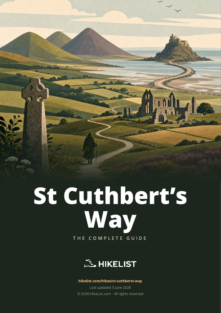
St Cuthbert’s Way
St Cuthbert's Way: A Borders-to-Holy Island Hiking Guide
HikeList Score
St Cuthbert’s Way scored 93/100 on HikeList's trail-quality metrics.
See score breakdownHide breakdown
- Ideal length 85
- Balanced challenge 100
- Scenery & wildness 91
- Varied terrain 100
- Accommodation 100
- Food & support 88
- Path quality 90
- Season flexibility 89
Computed from length, challenge, scenery & wildness, terrain variety, accommodation, food & support, path quality and season flexibility.
St Cuthbert's Way is a 100 km / 62 mile waymarked walk from Melrose Abbey in the Scottish Borders to the Holy Island of Lindisfarne in Northumberland. Most hikers take 5 days. It is a moderate point-to-point route: not technical or exposed, but with long stages, steady ascent over the Eildon Hills and Cheviot foothills, and a tidal final crossing. It suits walkers wanting a historic pilgrimage-style trail through Scotland and northern England.
Route Overview
The route runs west to east from Melrose to Lindisfarne and is waymarked in both directions, though most people walk with the prevailing wind behind them. It starts at Melrose Abbey, climbs by the Eildon Hills, follows the Tweed area through St Boswells and Harestanes, then reaches Morebattle and Wideopen Hill before crossing the border near Kirk Yetholm, where it meets the Pennine Way. In England it continues through Hethpool, the College Valley, Wooler, St Cuthbert's Cave and Fenwick before the low-tide crossing over Beal sands to Holy Island. Because it is linear, arrange end-of-walk transport around the Lindisfarne safe crossing times. For other Scottish routes, compare the Annandale Way, Arran Coastal Way and Ayrshire Coastal Path.
History of St Cuthbert's Way
St Cuthbert (c.634–687) was one of the major saints of early medieval northern Britain. He began monastic life at Melrose, later became prior and then Bishop of Lindisfarne, and was known for piety and miracles. After his death he was buried on Lindisfarne; when Viking raids forced the monks to flee in the late 9th century, they carried his body across the region, eventually to Durham. The modern trail was devised by Ron Shaw and opened in 1996.
Notable highlights
Melrose Abbey: The ruined 12th-century Cistercian abbey is the official start of the walk. It matters because St Cuthbert began his religious life at Melrose, and the abbey is reputed to hold the buried heart of Robert the Bruce.
Eildon Hills: Three distinctive volcanic peaks are crossed early in the route. They give wide views over the Scottish Borders and the River Tweed, and add some of the first real ascent.
Wideopen Hill (368 m): The highest point of St Cuthbert's Way and roughly the halfway point. Expect the steepest, most remote section between Morebattle and Kirk Yetholm, with 360-degree views in clear weather.
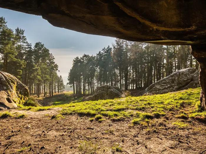
St Cuthbert's Cave: A sandstone overhang near Holburn, traditionally linked to the monks carrying St Cuthbert's body after leaving Lindisfarne. It is now cared for by the National Trust.
Lindisfarne / Holy Island: The tidal island finish is central to early English Christianity and associated with the Lindisfarne Gospels. Walkers reach it at low tide by the causeway road or the post-marked Pilgrims' Path across the sands.
Challenges to expect
The walking is approachable, but not effortless: several days are long, there is 2,075 m of total ascent, many stiles, and short steep climbs, especially around Wideopen Hill. Terrain ranges from riverside paths and farmland to woodland, open moorland, grassy Cheviot hills and minor roads. The main safety issue is the final Lindisfarne crossing: check published safe crossing times, as the causeway floods at high tide. Coastal hikers may also like the wilder Assynt Coastal Path.
HikeList Score
St Cuthbert’s Way scored 93/100 on HikeList's trail-quality metrics.
See score breakdownHide breakdown
- Ideal length 85
- Balanced challenge 100
- Scenery & wildness 91
- Varied terrain 100
- Accommodation 100
- Food & support 88
- Path quality 90
- Season flexibility 89
Computed from length, challenge, scenery & wildness, terrain variety, accommodation, food & support, path quality and season flexibility.
Show more data Show less
- Riverside
- Farmland
- Woodland
- Moorland
- Hills
- Coastal
- Grass
- Dirt
- Farm Tracks
- Forest Tracks
- Paved
- Sand
- Mud
- B&Bs
- Guesthouses
- Inns
- Hotels
- Bunkhouses
- Hostels
- Campsites
- Family Friendly
- Dog Friendly On Leash
- No Dogs Allowed
- Restrooms
- Established Campsites
- Visitor Center
- Public Transport Access Points
Download Our Full Guide to St Cuthbert’s Way FREE!
Get our comprehensive guide to this hike for free. Save it for later reading or print out at home.
In these collections
St Cuthbert’s Way: The Complete Guide
 i
Image by drhfoto
i
Image by drhfoto St Cuthbert’s Way is a 100 km cross-border walk from Melrose Abbey in the Scottish Borders to the tidal Holy Island of Lindisfarne in Northumberland. It suits reasonably fit walkers looking for a manageable long-distance route with history, varied terrain and a finish that feels genuinely different.
The trail starts with the Eildon Hills, follows Borders riverside paths and farmland, then climbs through the quieter ground around Wideopen Hill before reaching Kirk Yetholm. From there it enters Northumberland National Park, crossing the Cheviot foothills and College Valley before turning towards Wooler, St Cuthbert’s Cave and the coast.
Its pilgrimage thread is strong but not compulsory. Melrose Abbey, St Cuthbert’s Cave and Lindisfarne give the route a clear historical shape, while the walking itself remains a practical mix of field paths, tracks, moorland, woodland, minor roads and tidal sands.
The route is moderate rather than technical, but it still asks for steady days, hill fitness, patience with stiles and sensible logistics. The final crossing to Holy Island must be planned around the official Lindisfarne safe crossing times, whether using the causeway or the post-marked Pilgrims’ Path across the sands.
This guide covers stages, day-by-day planning, accommodation, food and water, transport, terrain and common mistakes.
Stage-by-Stage Guide
Stage 1: Melrose to Harestanes — 24 km / 15 miles, 6–8 hours
This is a substantial opening day, so an early start from Melrose Abbey is sensible. The stage begins with the steepest ground of the day: a climb onto the Eildon Hills, using clear grassy paths over open moorland, with broad views back over Melrose and the Tweed valley.
After the Eildons, the route descends to Bowden, a small village with no walker facilities, then turns east towards Newtown St Boswells and the River Tweed. Dryburgh Abbey is visible and close to the route, but requires a short detour.
The riverside section beside the Tweed is one of the gentler parts of the day, with grass and meadow paths that can become muddy after rain. The trail continues through St Boswells and Maxton before joining the line of Dere Street, the Roman road, on firmer tracks through rolling farmland.
Near the end of the stage the route passes the Monteviot estate beside the River Teviot and finishes at Harestanes Countryside Visitor Centre. Harestanes is a useful landmark and daytime service point, but it is not a village with accommodation.
Food and water: Melrose is the best place to buy supplies before setting off, with shops, cafes, pubs and restaurants. Newtown St Boswells is a slight detour from the main route and has services including the Dryburgh Arms, Main Street Trading Company and convenience stores; St Boswells has small shops. Harestanes has a seasonal cafe, open daily from April to October and Friday to Sunday from November to March, but opening should be checked before relying on it.
Accommodation: There is no accommodation at Harestanes itself. Options are off-route, including Ancrum, Newtown St Boswells and Jedburgh; Jedburgh has the widest range of services but requires onward transport or a longer detour. Some walkers split this first day at Newtown St Boswells, then continue beyond Harestanes the following day.
Transport and access: Harestanes has road access, with the nearest bus options around the B6400/A68 junction or Ancrum village. Public transport links also run to and from Jedburgh, but exact services should be checked before travelling.
Navigation and warnings: Waymarking is generally good, using the St Cuthbert’s Cross symbol, but farmland junctions need attention. The Eildon Hills climb is straightforward in clear weather but can be slippery when wet. Carry enough water for a long day, as reliable refill points are limited between Melrose and Harestanes.
Stage 2: Harestanes to Kirk Yetholm — 28 km / 17.5 miles, 6–7 hours
This is the hardest stage for many walkers because it combines the longest distance with the climb to Wideopen Hill. The day begins with riverbank, woodland, farm paths and tracks through agricultural land, where mud is common after wet weather.
The route uses the Monteviot Suspension Bridge and follows the River Teviot towards Jedfoot before turning south-east through woodland and farmland towards Cessford. Cessford Castle is a major landmark: a ruined medieval tower house associated with the Borders reivers.
From Cessford, minor road walking leads towards Morebattle, the main service point of the day. Beyond Morebattle, the character changes sharply as the trail climbs Grubbit Law to the ridge of Wideopen Hill, the highest point of St Cuthbert’s Way at 368 m and roughly the halfway point of the whole route.
The ridge gives wide views back towards the Eildons and across the Borders, but it is exposed in wind, rain or low cloud. The descent leads to Town Yetholm and then Kirk Yetholm, the border village also known as the northern end of the Pennine Way.
Food and water: Harestanes may have a seasonal cafe, but do not rely on it outside its published opening times. Morebattle has a village shop and pub, making it the key resupply and meal stop. Kirk Yetholm has The Border Hotel on the village green, with a bar, restaurant and accommodation; Town Yetholm has additional local options.
Accommodation: Kirk Yetholm and Town Yetholm are the normal overnight base for this stage. Morebattle also has accommodation and is the most practical place to split the stage if 28 km plus the Wideopen Hill climb is too much for one day. Mid-stage accommodation is otherwise limited.
Transport and access: Morebattle has road access but no regular bus service. Kirk Yetholm is served by bus, with Kelso the nearest larger service centre. There is no railway station in the Yetholms; the nearest railheads for wider travel are Tweedbank and Berwick-upon-Tweed.
Navigation and warnings: The route is well waymarked, but the section over Wideopen Hill needs more care in mist or low cloud. Carry a map, GPS backup and compass, and do not treat the hill as a casual finish to the day in bad weather. Expect some minor road walking, livestock fields, stiles and muddy field paths.
Stage 3: Kirk Yetholm to Wooler — 19.2 km / 12 miles, 6–7 hours
This stage leaves Scotland and crosses into England, with a more remote feel than the distance suggests. From Kirk Yetholm the trail climbs out on the same initial line as the Pennine Way, rising around Green Humbleton with views back over the Yetholms.
The route reaches the border ridge around Eccles Cairn, where a short detour is worthwhile in good visibility. This is the England–Scotland border crossing, and it marks an important change in access rights: Scotland’s statutory access rights, including responsible wild camping on unenclosed land, end here. In England, stay on rights of way and seek landowner permission for any wild camping.
After the border, St Cuthbert’s Way enters Northumberland National Park and descends via Elsdonburn to Hethpool at the head of the College Valley. This is one of the most remote-feeling sections of the route, with woodland, good tracks and open Cheviot foothills.
The trail passes beneath Yeavering Bell, a prominent hill and the site of Northumberland’s largest Iron Age hillfort, before approaching Wooler through the River Till valley. The route does not summit Yeavering Bell, but the hill is a strong landmark through the latter part of the stage.
Food and water: There are no food or water facilities between Kirk Yetholm and Wooler. Carry lunch, snacks and sufficient water from the start. Wooler has the full range of walker services, including shops, a Co-op supermarket, butchers, cafes, pubs, restaurants and takeaways.
Accommodation: Wooler is a strong overnight stop, with hotels, B&Bs, guesthouses, campsites and Wooler Hostel & Shepherd’s Huts, which has self-catering facilities and drying space. It is a well-established base for walking in the Cheviots.
Transport and access: Wooler has bus links to Berwick-upon-Tweed and Newcastle, but no railway station. Berwick-upon-Tweed is the nearest mainline station, on the East Coast Main Line.
Navigation and warnings: Waymarking is good, but the open ground near the border ridge, Gains Law and Humbleton Hill needs attention in poor visibility. The College Valley is remote and mobile signal can be poor. Expect boggy or muddy sections after rain, and carry all supplies needed for the full stage.
Stage 4: Wooler to Fenwick — 19 km / 11.5 miles, 5–6 hours
This stage heads east from Wooler towards the lowlands before the Holy Island crossing. It begins across Weetwood Moor, where the route passes prehistoric cup-and-ring rock carvings, then continues by Weetwood Bridge, quiet lanes, farm tracks and agricultural land.
The walking is generally less mountainous than the previous day, but it is still exposed in terms of resupply. The route crosses or passes close to the line of the Devil’s Causeway, a Roman road through Northumberland, before reaching the area around Holburn.
St Cuthbert’s Cave is the main landmark of the stage. This sandstone overhang, managed by the National Trust, is traditionally associated with the monks carrying St Cuthbert’s body after leaving Lindisfarne. It is reached on foot from the trail and is one of the most important historical stops before Holy Island.
From the cave the route continues north-east through farmland towards Fenwick. Fenwick is a small, quiet settlement and is best treated as a practical staging point for the final tidal crossing rather than a full-service trail town.
Food and water: Beyond Wooler there are no food services directly on the route until the Fenwick and Beal area. Carry food and water for the day from Wooler. Lowick is off-route and has a pub; the Lindisfarne Inn at Beal is a useful option for meals, packed lunches and water refills if staying or detouring there.
Accommodation: Fenwick has limited B&B and guesthouse options. Beal, reached by continuing or detouring beyond Fenwick, is a practical alternative before the final crossing, with the Lindisfarne Inn offering walker-focused accommodation and facilities. Staying at Beal can make tide planning for the next morning easier.
Transport and access: Public transport is limited in the Fenwick and Beal area. Borders Buses service 477 links Berwick-upon-Tweed and Holy Island / the Beal area, but it runs around tide-dependent crossing times, so the current timetable must be checked carefully. Taxis from Berwick-upon-Tweed are often the more flexible option.
Navigation and warnings: Navigation is generally straightforward on tracks, lanes and signed paths, and St Cuthbert’s Cave is signed from the trail. The main planning issue is not navigation but timing: check the official Northumberland County Council Holy Island crossing times before leaving Wooler or Fenwick, so the next stage is not forced into an unsafe tide window.
Stage 5: Fenwick to Holy Island of Lindisfarne — 10 km / 6 miles, 2–4 hours
The final stage is short in distance but governed entirely by the tide. From Fenwick the route follows historic paths and farm tracks towards the coast, passing Fenwick Granary, crossing the East Coast Main Line and Beal Cast Burn, then passing wartime coastal defence remains before reaching the Holy Island causeway.
There are two possible final crossings. The causeway road is the modern tarmac route across the sands and is the safer, more certain option. The Pilgrims’ Path is the traditional route across the open sands, marked by wooden posts, and should only be used in daylight when the sands are exposed; its safe timing differs from the road causeway.
The tide is the critical safety issue on St Cuthbert’s Way. The causeway is covered by the sea twice daily, and fast incoming tides regularly cut off people who misjudge the timing. Always use the official Northumberland County Council Holy Island safe crossing times before setting out, allow at least two hours for the crossing, and never cross on a rising tide.
If using the Pilgrims’ Path, follow the posts exactly and do not stray across the sands. The surface can be slippery, and trekking poles are useful. Walkers without local knowledge should not attempt the Pilgrims’ Path alone.
Once on Holy Island, the finish brings the route into the village and the historic Lindisfarne area. Lindisfarne Priory is the key endpoint landmark, with Lindisfarne Castle also on the island.
Food and water: Holy Island has pubs, restaurants, a visitor centre cafe and some shops, but opening is seasonal and more limited outside the main visitor period. The Ship Inn, The Crown & Anchor and the Manor House Hotel are among the island options for food or drink. The Lindisfarne Inn at Beal is the main mainland service point before the crossing.
Accommodation: Holy Island accommodation is limited and should be booked well ahead, especially in summer and at weekends. Options include pubs, hotels, guesthouses and self-catering cottages, but one-night stays can be harder to secure. If not staying on the island, Beal is the most convenient mainland base.
Transport and access: Borders Buses service 477 links Holy Island with Berwick-upon-Tweed, but it operates around the tide-dependent crossing times and must be checked before travel. Taxis to Berwick-upon-Tweed are another option. Berwick-upon-Tweed station is on the East Coast Main Line, with direct trains towards Edinburgh and London.
Navigation and warnings: The route from Fenwick to the coast is straightforward, and the causeway is well signed. The danger is arriving outside the safe crossing window: if the tide is wrong, wait. There is a pedestrian refuge box on the causeway for emergencies, but it is not a planning fallback.
Recommended Itinerary
Standard 5-day itinerary
This is the official and most common way to walk St Cuthbert's Way. It keeps the daily distances manageable for reasonably fit walkers, but Day 2 is still a long hill day and the final day must be planned around the Holy Island safe crossing times.
| Day | From | To | Approx. distance | Why this stage makes sense | Services/accommodation notes |
|---|---|---|---|---|---|
| 1 | Melrose | Harestanes | 24 km / 15 mi | A varied first day from Melrose Abbey over the Eildon Hills, then through Bowden, Newtown St Boswells, St Boswells, Maxton and towards Harestanes. It gets the main early climb done while still leaving a practical end point near the Jedburgh accommodation area. | Melrose has full start-town services. St Boswells has a pub and small shop. Harestanes has no accommodation at the visitor centre and the café is seasonal, so arrange a nearby B&B, stay off-route in Ancrum, or use Jedburgh, about 4 km away by taxi or bus. |
| 2 | Harestanes | Kirk Yetholm | 28 km / 17.5 mi | The longest and toughest stage, crossing open Borders farmland via Cessford and Morebattle before the steep climb to Wideopen Hill, the route high point at 368 m. Finishing in Kirk Yetholm places you at the Pennine Way meeting point and ready for the Northumberland stage. | Morebattle is the key midway refuel, with a pub offering accommodation and meals plus a small shop. Kirk Yetholm has pub accommodation, hostel and B&B options; Town Yetholm, about 1 km away, has a shop. Book ahead, as this is a small border village. |
| 3 | Kirk Yetholm | Wooler | 19 km / 12 mi | A shorter but remote day over the England–Scotland border and through the College Valley in Northumberland National Park. The distance is sensible after the previous long day, with Wooler providing the best resupply point on the English side. | There are no services between Kirk Yetholm and Wooler. Wooler is a proper market town with supermarket, shops, pubs, cafés, restaurants and a wide choice of accommodation. |
| 4 | Wooler | Fenwick | 19 km / 11.5 mi | This stage crosses rolling Northumberland farmland, Weetwood Moor, the Roman Devil's Causeway and St Cuthbert's Cave before reaching the lowland approach to Holy Island. It avoids making the tide-dependent finish too long. | Stock up in Wooler before leaving. Fenwick is a very small hamlet with no shop or pub, though there are some B&Bs. Many walkers continue or transfer to the Beal area, where the Lindisfarne Inn provides pub accommodation. |
| 5 | Fenwick | Holy Island of Lindisfarne | 10 km / 6 mi | A deliberately short final day because the crossing to Holy Island is controlled by the tide. Start time should be set by the official Lindisfarne safe crossing window, not by habit or breakfast time. | Check the official Northumberland County Council Lindisfarne safe crossing times before travelling and again before crossing. Holy Island has cafés, pubs, restaurants, shops and accommodation, but places fill quickly in high season and on popular walking weekends. |
Slower 6–7 day options
A slower itinerary suits first-time long-distance walkers, families, pilgrimage walkers wanting a more reflective pace, or anyone who wants time for Jedburgh and Lindisfarne. It is also useful if the standard Day 2 distance from Harestanes to Kirk Yetholm feels too long.
| Day | From | To | Approx. distance | Why this stage makes sense | Services/accommodation notes |
|---|---|---|---|---|---|
| 1 | Melrose | St Boswells | 12 km / 7.5 mi | Splits the opening day and keeps the Eildon Hills from being combined with a full 24 km stage. | St Boswells has a pub, small shop and some accommodation. Book ahead. |
| 2 | St Boswells | Harestanes / Jedburgh area | 12 km / 7.5 mi | Leaves time for the River Tweed, Maxton and the approach to Harestanes without rushing. | Harestanes has no accommodation at the visitor centre. Use nearby accommodation, Ancrum, or Jedburgh by short taxi or bus transfer. |
| 3 | Harestanes / Jedburgh area | Morebattle | Approx. 10 km from Harestanes | A useful split of the hardest standard stage, ending before the climb over Wideopen Hill. | Morebattle has a pub with accommodation and meals, plus a small shop. This is the logical overnight before the high point. |
| 4 | Morebattle | Kirk Yetholm | Check official mapping before booking | Keeps Wideopen Hill as a shorter focused hill day rather than the second half of a 28 km push. | Kirk Yetholm and nearby Town Yetholm have limited village services, including pub accommodation, hostel, B&Bs and a shop in Town Yetholm. |
| 5 | Kirk Yetholm | Wooler | 19 km / 12 mi | Crosses into England through the Cheviot foothills and College Valley, then finishes at the main resupply town. | No services en route. Wooler has the best range of shops, food and accommodation before Holy Island. |
| 6 | Wooler | Fenwick / Beal area | 19 km / 11.5 mi to Fenwick | Keeps the St Cuthbert's Cave and Kyloe Hills section separate from the tidal crossing day. | Fenwick has minimal services. Beal has pub accommodation. Stock up in Wooler. |
| 7 | Fenwick / Beal area | Holy Island of Lindisfarne | 10 km / 6 mi from Fenwick | Allows the final crossing to be timed safely and without pressure. | Book Holy Island accommodation well in advance, or arrange onward transport in line with the tide-linked bus or a pre-booked taxi. |
Another slower arrangement is to keep the official first day from Melrose to Harestanes, then take a rest or short-transfer night in Jedburgh before continuing. This works well if accommodation around Harestanes is limited, but transport between Harestanes and Jedburgh should be arranged before travelling.
Faster 4-day itinerary
The 4-day version is for experienced walkers who are comfortable with long days and can plan the final approach around the tide. The key difference is that the Fenwick overnight is removed, creating a long final day from Wooler to Lindisfarne.
| Day | From | To | Approx. distance | Why this stage makes sense | Services/accommodation notes |
|---|---|---|---|---|---|
| 1 | Melrose | Harestanes | 24 km / 15 mi | Follows the standard opening stage over the Eildon Hills and through the Tweed-side Borders countryside. | No accommodation at Harestanes itself; arrange nearby accommodation or transfer to Jedburgh. |
| 2 | Harestanes | Kirk Yetholm | 28 km / 17.5 mi | Keeps the official long hill stage intact, including Morebattle and Wideopen Hill. | Morebattle is the main refuel. Kirk Yetholm accommodation should be booked early. |
| 3 | Kirk Yetholm | Wooler | 19 km / 12 mi | A shorter remote stage over the border and through the College Valley, ending at the last full-service town before the coast. | No services between Kirk Yetholm and Wooler. Resupply fully in Wooler. |
| 4 | Wooler | Holy Island of Lindisfarne | 28.8 km / 18 mi | Combines the Wooler–Fenwick stage with the final tidal crossing. This saves a day but leaves very little margin if the safe crossing window is awkward. | Plan the whole day backwards from the official Lindisfarne safe crossing times. Do not attempt the causeway or Pilgrims' Path outside the published safe window; high wind and poor weather can also affect safety. |
Choosing the right pace
The 5-day itinerary is the best default for most walkers: long enough to feel like a proper crossing, but not so compressed that every day becomes a race. The main booking complication is the Harestanes overnight, because the visitor centre is not an accommodation stop.
Choose the slower version if shorter days, more village time or a Jedburgh visit matter more than finishing quickly. Choose the faster version only if 24–29 km days are already comfortable and the Holy Island tide window fits the final day's walking plan.
Planning the Route
How many days to allow
Most walkers should plan St Cuthbert’s Way as a 5-day walk. This is the official itinerary and the most natural fit for the spacing of accommodation and services along the route.
A 4-day crossing is realistic for fit walkers, but it makes the final part harder to manage. The usual compromise is to walk Wooler to Holy Island in one long stage of about 29 km / 18 miles, which still has to fit the Lindisfarne tide window.
A 6-day itinerary is often the better choice if you want shorter days, more time at the abbeys and historic sites, or a less rushed pilgrimage-style walk. Commercial walking companies also offer 7–9 day versions with very short daily distances, typically around 14–16 km per day.
| Pace | Best for | Main trade-off |
|---|---|---|
| 4 days | Strong walkers with light packs | Long final stage and tighter tide planning |
| 5 days | Most independent walkers | One long day to Kirk Yetholm |
| 6 days | Leisurely walkers, pilgrims, first-time long-distance hikers | More accommodation bookings to line up |
| 7–9 days | Very short walking days | Higher accommodation cost and more logistics |
The standard 5-day structure
The usual 5-day plan is shaped more by overnight stops than by perfectly even daily distances. The first two days are the longest, so arrive in Melrose rested rather than treating the opening stage as an easy warm-up.
| Day | Stage | Approx. distance | Planning notes |
|---|---|---|---|
| 1 | Melrose to Harestanes | 24 km | A substantial first day over the Eildon Hills and through the Tweed-side countryside. St Boswells, around halfway, is a useful alternative overnight stop. |
| 2 | Harestanes to Kirk Yetholm | 28 km | The longest stage, with Wideopen Hill and a more remote feel after Morebattle. Stock up before leaving Morebattle. |
| 3 | Kirk Yetholm to Wooler | 19 km | The most remote day, crossing the border area and the Cheviot foothills. There are virtually no services between the endpoints. |
| 4 | Wooler to Fenwick | 19 km | A practical positioning day before the tidal crossing to Holy Island. |
| 5 | Fenwick to Holy Island | 10 km | Short in distance but completely controlled by the safe crossing times for Lindisfarne. |
Accommodation drives the itinerary
Book accommodation before finalising travel, baggage transfer or restaurant plans. This is especially important in Holy Island, Morebattle, Crailing and the Harestanes/Ancrum area, where options are limited.
Harestanes has very limited accommodation directly on the route. A common workaround is to leave the trail near the Harestanes/Ancrum area, travel to Jedburgh for the night, then return the next morning; Jedburgh has a wider choice of hotels, B&Bs and places to eat. This should be checked before travelling, particularly for current bus times.
Kirk Yetholm and nearby Town Yetholm have a reasonable village-level choice, including hostel, hotel and B&B options, but they are popular with both St Cuthbert’s Way walkers and Pennine Way walkers. Book ahead rather than assuming a room will be available.
Wooler is the strongest service hub on the Northumberland side, with the widest spread of accommodation. Fenwick and the Beal area are useful for splitting the approach to Holy Island, but options are fewer and can be expensive.
Holy Island itself has very limited accommodation and very high demand in the main walking season. For April–May and July–August, book as early as possible; 4–6 months ahead is sensible, and some holiday lets may be taken much earlier.
The tide is the key final-stage decision
The final crossing to Holy Island is the one piece of planning that cannot be improvised. The causeway road and the post-marked Pilgrims’ Path across the sands are passable only at low tide.
Use the official Northumberland County Council Lindisfarne safe crossing times before setting your final day: holyislandcrossingtimes.northumberland.gov.uk. Do not cross outside the safe window.
The Pilgrims’ Path is about 5 km / 3.2 miles and typically takes 75–120 minutes. It should be started roughly 2 hours before low tide; the road causeway normally has a longer usable window, but it still depends on the published safe crossing times.
For this reason, Fenwick is a practical overnight stop before Holy Island. It lets you treat the final day as a timed crossing rather than trying to force a longer walking day to fit the tide.
Food and water planning
Do not rely on finding food at every village. Small shops, pubs and cafés can have limited hours, and evening meals in villages such as Kirk Yetholm should be booked ahead, especially in peak season.
The Kirk Yetholm to Wooler stage needs the most careful food planning. There are virtually no services between the two endpoints, so carry lunch, snacks and enough water from the start of the day.
Morebattle is an important resupply point on the long Harestanes to Kirk Yetholm stage. After Morebattle, the route heads into the most exposed and remote part of that day over Wideopen Hill.
A water capacity of at least 2–2.5 litres is sensible, particularly in warm weather and on the remote sections. Refill opportunities should be planned around overnight stops and known villages rather than assumed on the hill.
Navigation and terrain decisions
St Cuthbert’s Way is generally well waymarked, with white cross markers, and it is signed in both directions. Most walkers still go west to east, from Melrose to Lindisfarne, because that gives the route its traditional pilgrimage direction and finishes with the tidal crossing.
Carry a map or offline digital mapping, plus a GPX backup. This is most useful on the Cheviot foothills section between Kirk Yetholm and Wooler and in poor visibility on more open ground.
The route is not technical, but the walking is varied: riverside paths, farm tracks, woodland, grass, moorland, mud, lanes and the final sands to Holy Island. Many stiles make a very heavy pack more awkward than the distance alone suggests.
Shortening, extending and splitting stages
The easiest place to soften the opening day is St Boswells, which breaks Melrose to Harestanes into a shorter first stage. Jedburgh is another practical overnight option via the Harestanes/Monteviot area, though it involves leaving the direct line of the route.
Morebattle can be used to split the long Harestanes to Kirk Yetholm day, but accommodation is limited and should be booked early. Fenwick is the most useful split before Holy Island because it separates the approach from the tide-dependent crossing.
The hardest section to shorten without arranged transport is Kirk Yetholm to Wooler. There are no convenient mid-stage service villages, so section hikers or slower walkers may need a taxi or accommodation shuttle.
Jedburgh Abbey can be added as a detour from the Monteviot/Harestanes area, and Dryburgh Abbey is a short off-route option near St Boswells. Add these only if the day’s distance and onward transport still work.
Section hiking
Section hiking is practical, but it takes more organisation than a continuous walk. Local buses link several Scottish Borders settlements including Melrose, St Boswells, Jedburgh, Morebattle, Kelso and Yetholm, while taxis may be needed for more awkward sections.
A common broad split is the Scottish half from Melrose to Kirk Yetholm, followed by the English half from Kirk Yetholm to Holy Island. The Scottish half is about 52 km and works well over 2 days for strong walkers; the English half is about 48 km and is more naturally spread over 3 days because of the Wooler and Fenwick stops and the Holy Island tide.
The Kirk Yetholm to Wooler stage is the least transport-friendly part of the route. Anyone walking isolated sections should arrange pick-ups in advance rather than depending on finding transport at the end of the day.
Access, camping and baggage transfer
Access rules change as the route crosses from Scotland into England. On the Scottish section, statutory access rights and responsible wild camping apply under the Scottish Outdoor Access Code.
From the Kirk Yetholm/Hethpool area onwards, the route is in England, where there is no general right to wild camp. Use formal campsites where available, or seek the landowner’s permission for any off-route camping. Camping is not available on Holy Island.
Inn-to-inn walkers should prioritise accommodation and tide timing. Once those are fixed, baggage transfer, meals and transport can usually be arranged around them.
Baggage transfer is widely used on this route. The official St Cuthbert’s Way website lists providers, and companies such as Absolute Escapes, Macs Adventure, Mickledore Travel, Hillwalk Tours, Brigantes and The Natural Adventure offer walking packages or luggage support. Prices and current operating dates should be checked before booking.
Transport at the start and finish
For the start, the nearest railway station is Tweedbank on the Borders Railway, about 2 miles from Melrose. Trains from Edinburgh Waverley to Tweedbank take roughly 55–60 minutes, with onward bus or taxi connections to Melrose.
For the finish, plan the journey home before walking the final stage. Borders Buses service 477 links Holy Island with Berwick-upon-Tweed, but it runs around the tide-dependent safe crossing times and may operate only 1–2 times daily.
A pre-booked taxi from Holy Island to Berwick-upon-Tweed is often the simplest option; recent planning estimates put this at around £20, but current prices should be confirmed before travelling. From Berwick-upon-Tweed, trains on the East Coast Main Line run north to Edinburgh and south towards London King’s Cross.
Season and weather planning
May to September is the main walking season and usually gives the best balance of daylight, accommodation availability and weather. April and October can work well, but expect colder, wetter conditions, especially on the Cheviot sections.
January and February are poor planning choices for most walkers because of short daylight, accommodation closures and the possibility of snow or winter conditions on higher ground such as Wideopen Hill.
Ticks are present from April to September, so carry a tick remover and check skin after grassy or bracken-lined sections. Adders are occasionally encountered on moorland; give them space and keep to the path where possible.
Towns, Villages and Overnight Stops
St Cuthbert’s Way has enough services for an independent walker, but they are unevenly spaced. Melrose, Kirk Yetholm and Wooler are the key hiker bases; Harestanes, Morebattle, Fenwick and Holy Island need more careful booking because accommodation is limited or indirect.
For the standard 5-day itinerary, the usual overnight pattern is Melrose, Harestanes/Jedburgh, Kirk Yetholm, Wooler, Fenwick and Holy Island. Slower itineraries often use St Boswells or Morebattle to shorten the long early stages.
Melrose
Melrose is the official start of the route, with the way beginning at Melrose Abbey. It is the best-served town on the Scottish section and the most convenient place to stay the night before starting.
Accommodation is plentiful by trail standards, with B&Bs, small hotels and inns in the centre. Options include Braidwood B&B, Old Bank House, Old Abbey School, Fiorlin B&B, Burt’s Hotel, the Townhouse Hotel and the Station Hotel. Book early for summer weekends and bank holidays.
Food is straightforward here. Marmions Brasserie, Eden Café, the Kings Arms, the Ship Inn and the Station Hotel restaurant are all central options, and the town has a useful mix of cafés, restaurants and takeaway choices.
The nearest railway station is Tweedbank on the Borders Railway, about 2 miles from Melrose by bus or taxi. Trains run between Tweedbank and Edinburgh in roughly 55–60 minutes, and Borders Buses 67/68 link Tweedbank with Melrose; current times should be checked before travelling.
Newtown St Boswells and St Boswells
Newtown St Boswells and St Boswells sit in the Tweed valley on the first day from Melrose, before the route continues towards Harestanes. They are useful for resupply and occasional overnight stops, especially if splitting the first stage.
Newtown St Boswells has a Co-op supermarket, public toilets, a bank and the Lunch Box sandwich shop. This is one of the more practical places to buy food before the route becomes quieter later in the day.
St Boswells has the Buccleuch Arms Hotel for food and rooms, plus Main Street Trading Company, a well-regarded bookshop and café. Dryburgh Abbey Hotel is in the wider area, though Dryburgh is around 3 miles from the route.
There is no railway station here. Buses link the area with Galashiels and Melrose, but walkers relying on public transport should check current services before planning a stage around them.
Harestanes, Ancrum and Jedburgh
Harestanes is the standard end point for Day 1 on the official 5-day itinerary, around 24 km from Melrose. It works well as a walking-stage finish, but not as a self-contained overnight base.
The Harestanes Countryside Visitor Centre has toilets, parking and a café option in season, including Ancrum Pantry / Out There Artisan café. It is generally open daily from early April to the end of October; off-season walkers should not rely on it being open.
There is no accommodation at Harestanes itself. Most walkers ending the day here use Jedburgh, about 3 miles off-route, or B&Bs in nearby Ancrum.
Jedburgh is the practical overnight choice if staying near Harestanes, with hotels, B&Bs, pubs, restaurants and shops. The detour adds logistics at the end and start of the walking day, so pre-arranged taxi or accommodation transfer details should be sorted before arrival.
Ancrum is a smaller alternative, with Ancrum Organic Village Store and Ancrum Pantry providing local food options. Availability is limited compared with Jedburgh, so book ahead rather than assuming space will be available.
Cessford
Cessford is a tiny hamlet on the second day, best treated as a passage point rather than a stop. The main landmark is the ruin of Cessford Castle, visible from the path.
There are no shops, pub or accommodation here. Carry food and water from your overnight stop or from Morebattle, depending on your direction and itinerary.
Morebattle
Morebattle is a small Borders village on the route between Harestanes and Kirk Yetholm. It is one of the most useful places on the long second day and a sensible overnight option for walkers who do not want to complete the full Harestanes–Kirk Yetholm stage in one go.
Morebattle Community Shop is a genuine trail resource, selling sandwiches, snacks and fresh produce, with free water-bottle refills. Public toilets are available across the road.
The Templehall Inn on Main Street offers en-suite rooms, a licensed bar and evening meals. It is a good choice for splitting the long stage before the climb towards Wideopen Hill and Kirk Yetholm.
Do not leave Morebattle short of food or drink unless already carrying enough. The next section over Wideopen Hill is the highest and one of the more remote parts of the route.
Town Yetholm and Kirk Yetholm
Town Yetholm and Kirk Yetholm are twin villages in the Scottish Borders, separated by the Bowmont Water. The route passes through Town Yetholm and reaches Kirk Yetholm, the usual end of Day 2 on the standard itinerary.
Kirk Yetholm is a major walker village because it is also the northern terminus of the Pennine Way. It is one of the key overnight stops on St Cuthbert’s Way and should be booked early in the main walking season.
Accommodation options include the Border Hotel in Kirk Yetholm, Mill House B&B, Farmhouse at Yetholm Mill, Friends of Nature House, Cross Keys B&B, Rutherford House B&B and Blunty’s Mill B&B. In Town Yetholm, the Plough Hotel has letting rooms and pub meals.
Food and drink are available at the Border Hotel and the Plough Hotel, and there is a community-owned shop in the village. This is a good place to check supplies before crossing into the quieter Northumberland section.
Kirk Yetholm is the last Scottish village on the route. From here the trail crosses into Northumberland National Park, where there is no general right to wild camp; landowner permission should be sought if planning to camp outside formal sites.
Holy Island accommodation should already be booked before reaching Kirk Yetholm. From here, most walkers are only two walking days from the finish, and rooms on the island can be fully booked well ahead.
Hethpool and the College Valley
Hethpool is a small hamlet in the College Valley, shortly after the route enters England and Northumberland National Park. It sits on one of the more isolated and scenic sections in the Cheviot foothills.
There are no shops or general services at Hethpool. Treat this as a remote walking section, not a resupply point.
Some walkers use accommodation at or near Hethpool, including holiday cottages on the College Valley Estate or limited options around Kirknewton a few miles north. These arrangements need planning because there is no large village service base here.
Water may be available from streams in the valley, but it should be filtered or treated. Carry enough food from Kirk Yetholm or arrange packed lunches through accommodation.
Wooler
Wooler is the main service hub on the English section and the standard end of Day 3. It is the best place after Melrose to resupply, repair kit and take a more comfortable overnight stop.
Accommodation includes Wooler Hostel & Shepherds Huts, the Black Bull Inn, B&Bs and self-catering cottages. The hostel is popular with long-distance walkers and groups, so summer bookings should be made well ahead.
Food and drink options include the Black Bull Inn, Ad Gefrin Bistro, Terrace Café and other cafés and pubs around the High Street. Ad Gefrin is also a whisky and gin distillery in Wooler.
For supplies, Wooler has a Co-op supermarket within walking distance of the hostel, independent bakeries and an outdoor gear shop. This is the last guaranteed full resupply point before Holy Island.
Wooler has no railway station. Bus services run to Berwick-upon-Tweed, where the East Coast Main Line gives onward rail connections to Edinburgh, Newcastle and London, but frequencies are limited and current timetables should be checked before travelling.
St Cuthbert’s Cave and Holburn
St Cuthbert’s Cave is a landmark on the Wooler to Fenwick stage, near Holburn. It is a sandstone overhang associated with the monks who carried St Cuthbert’s body after leaving Lindisfarne.
This is not a service stop. The cave and nearby Holburn have no shops, pubs or accommodation for walkers to rely on.
In the wider area, the Fenton Centre at Fenton has a café, farm shop and nature trail, while Café Maelmin at Milfield is another refreshment option. Opening hours can vary, so this should be checked before travelling if planning the day around them.
Fenwick
Fenwick is the standard final mainland overnight on the 5-day itinerary, usually reached at the end of Day 4. It is a small Northumbrian hamlet, useful mainly because it positions walkers close to the Holy Island crossing.
Accommodation is limited to a handful of B&Bs, including Manor House, 7 The Village and Fenwick. Book early, as there are few fallback options if rooms are full.
There is no pub or shop in Fenwick itself. Evening meals, packed lunches and breakfast arrangements should be confirmed with accommodation before arrival.
Whether Fenwick is the best overnight stop depends on the next day’s Lindisfarne safe crossing times. If the tide window is late in the day, some walkers may choose to start later or stay elsewhere; if it is early, Fenwick can be the most practical base.
Beal
Beal sits near the Holy Island road and the causeway junction, making it a useful last mainland stop before the tidal crossing. It can work as either a refreshment stop, an overnight alternative to Fenwick, or a practical staging point if the tide window is awkward.
The Barn at Beal has a restaurant and coffee shop and is popular with walkers before or after the crossing. Brockmill Farmhouse B&B offers accommodation close to the route, and the Lindisfarne Inn near the A1/Holy Island road junction has food, bar facilities and rooms.
There are no general shops at Beal. Stock up properly in Wooler, and do not assume Holy Island will have walker-style grocery supplies on arrival.
Holy Island of Lindisfarne
Holy Island is the finish of St Cuthbert’s Way and the most logistics-sensitive overnight stop on the route. It is a tidal island, reached only during the safe low-tide window by the causeway road or the post-marked Pilgrims’ Path across the sands.
Always check the official Northumberland County Council Lindisfarne safe crossing times before setting out for the final stage. Never cross outside the safe window; if the tide is missed, the only safe option is to wait.
The causeway road is tarmac and shared with vehicles, with no pavement. The Pilgrims’ Path is the more traditional walking line across the sands, marked by wooden posts, but it can be wet and muddy; gaiters or waterproof footwear are sensible.
Accommodation on the island is limited and fills very quickly in peak season and at weekends. Options include B&Bs and guesthouses such as Belvue Guesthouse, the Crown and Anchor Inn, the Manor House Hotel and small hotels; holiday lets often require minimum stays.
Food and drink options include The Ship Inn, Crown and Anchor Inn, Manor House Hotel bar, Pilgrims Coffee House and Celtic Craft, Oasis Café and Coffee Shop, and Café Beangoose. Evening meals should be reserved ahead in busy periods.
Shops on Holy Island are mainly gift shops and galleries rather than full resupply stores. St Aidan’s Winery sells Lindisfarne Mead, local produce, beers and wines, but walkers should not treat the island as a supermarket stop.
Public transport off the island is tide-dependent. Borders Buses service 477 links Holy Island with Berwick-upon-Tweed, where there are East Coast Main Line trains, but the bus timetable follows the safe crossing times and should be checked before travelling.
A pre-booked taxi to Berwick can be useful if the bus timing does not work or if leaving late in the day. Public toilets are usually available seasonally next to the Village Hall, roughly from March to October.
Getting to the Start
The official start of St Cuthbert’s Way is Melrose Abbey on Abbey Street, Melrose, TD6 9LG. Melrose has no railway station, so most walkers arrive via Tweedbank or Galashiels, then use a short bus, taxi or walk into town.
By train
The nearest railway station is Tweedbank, on the Borders Railway. ScotRail runs direct trains from Edinburgh Waverley to Tweedbank, taking about 55–60 minutes.
Services are fairly frequent for a rural trailhead: typically around two trains per hour Monday to Saturday and roughly hourly on Sundays. Exact times, engineering works and seasonal changes should be checked before travelling.
| Leg | Typical option | Notes |
|---|---|---|
| Edinburgh Waverley to Tweedbank | ScotRail Borders Railway | About 55–60 minutes |
| Tweedbank to Melrose | Borders Buses 67 or 68 | Around 10 minutes; roughly every 30 minutes |
| Tweedbank to Melrose on foot | Riverside walk | About 20–30 minutes |
| Tweedbank to Melrose by taxi | Local taxi | About 5 minutes; roughly £5–8 |
A useful detail: Borders Buses 67 and 68 do not serve Tweedbank Rail Station between roughly 09:30 and 14:30. During that window, use the stops on Tweedbank Drive, just outside the station. This should be checked before travelling.
An alternative is to leave the train at Galashiels, where the transport interchange is directly across from the station. From there, Borders Buses 67 or 68 run to Melrose in about 10 minutes.
For walkers arriving from elsewhere in Britain, the simplest rail plan is usually to reach Edinburgh Waverley, then take the Borders Railway south to Tweedbank or Galashiels.
By bus
Borders Buses provide the main bus access to Melrose. Service 51 runs between Galashiels and Edinburgh, calling at Melrose on its route via places including Borders General Hospital, Newtown St Boswells, Earlston, Lauder and Pathhead.
The direct bus from Edinburgh to Melrose takes about 1 hour 50 minutes. Saturday services are more numerous than Sunday services, when the timetable is much thinner, with around three services per day.
Another option is Borders Buses X95 from Edinburgh to Galashiels, then a change at Galashiels Interchange for service 67 or 68 to Melrose.
The Borders Explorer combined rail-and-bus day ticket can be good value for same-day travel to the start. Current prices, validity and bus times should be checked before travelling at Borders Buses, ScotRail or Traveline Scotland.
By car
Melrose is close to the A68 and A7 trunk roads. From the A68, take the A6091 towards Galashiels, then turn onto the B6374 signed for Melrose.
Typical driving times are:
| From | Approximate drive |
|---|---|
| Edinburgh | 50–60 minutes |
| Newcastle | About 1 hour 20 minutes |
There is a Pay & Display public car park about 75 m from Melrose Abbey, run by Scottish Borders Council, with electric charging points. It can be busy in summer, and there is also on-road parking near the abbey.
Long-stay parking is the main car-logistics issue. There is no dedicated long-stay walker car park in Melrose for leaving a vehicle for several days, so do not assume the abbey car park is suitable for a full-route walk.
Common options are:
- ask booked accommodation in Melrose whether a car can be left during the walk;
- check whether Buccleuch Street car park is suitable for the required duration;
- leave the car at Tweedbank Park & Ride and take the bus or a taxi into Melrose;
- arrange a lift to the start and a taxi or transfer back after finishing on Holy Island.
Any multi-day parking plan should be checked before travelling, including current restrictions, charges and overnight rules.
From the nearest airport
Edinburgh Airport is the nearest airport to Melrose, about 46 miles away. By car or pre-booked transfer the journey is roughly 54 minutes, with private transfers commonly around £60–90 depending on operator and timing. Confirm current prices before booking.
By public transport from Edinburgh Airport, take the tram into central Edinburgh, then either travel by ScotRail from Edinburgh Waverley to Tweedbank and continue by bus, taxi or on foot to Melrose, or use a Borders Buses service from Edinburgh. Allow roughly 2.5–3 hours overall, depending on connections.
Newcastle Airport is also workable, especially for walkers combining arrival plans with onward travel from the finish at Berwick-upon-Tweed. The drive to Melrose is about 66 miles and roughly 1 hour 20 minutes. Public transport requires connections via Newcastle Central and the East Coast Main Line or via Berwick and Borders bus links; this should be checked before travelling.
Where to stay before starting
Staying in Melrose the night before the walk is the easiest way to make an unhurried start from Melrose Abbey. This is especially sensible if using public transport from Edinburgh or arriving by air.
Melrose has a good range of walker-friendly accommodation, but it is a popular small town and summer weekends can book out. Reserve early if starting during holiday periods or if a baggage-transfer company needs a fixed first-night address.
Central hotel options include Burts Hotel on Market Square, The George and Abbotsford Hotel on High Street, and Townhouse Hotel on Market Square. B&B options include Braidwood on Buccleuch Street, Dunfermline House, Fiorlin on Abbey Street, and Old Bank House.
The official St Cuthbert’s Way accommodation listings and baggage-transfer providers are useful for finding places accustomed to walkers. If leaving a car in Melrose, ask accommodation directly about parking before booking.
Getting Home from the Finish
Leaving St Cuthbert’s Way needs more planning than most inland trails because the finish is on the tidal Holy Island of Lindisfarne. The island is reached and left by the minor causeway road that runs off the A1 at Beal, or by the post-marked Pilgrims’ Path across the sands, both of which are only usable at low tide.
Always plan the final day around the official Northumberland County Council Lindisfarne safe crossing times: https://holyislandcrossingtimes.northumberland.gov.uk/. Do not attempt to cross outside the published safe window, and remember that buses, taxis and private pick-ups also have to work around the same tide times.
By train
The nearest mainline railway station is Berwick-upon-Tweed, around 15–16 miles by road from Holy Island. Berwick is on the East Coast Main Line, with direct services north to Edinburgh and south to Newcastle and London.
Typical journey times from Berwick-upon-Tweed are:
| Destination | Typical train time | Notes |
|---|---|---|
| Edinburgh Waverley | about 41–47 minutes | Fast, regular LNER services; fewer on Sundays |
| Newcastle upon Tyne | about 42–48 minutes | Regular services southbound |
| London King’s Cross | about 3h 45m–4h 15m | LNER services, usually best booked in advance |
| York, Leeds, Peterborough and beyond | varies | Usually via direct or connecting East Coast Main Line services |
LNER is the main fast operator at Berwick, with TransPennine Express and some CrossCountry services also serving the station. Train times and fares should be checked before booking, especially if the day’s safe causeway window gives only a narrow connection.
From Holy Island to Berwick station, use the 477 bus if it fits your finish day and tide window, or pre-book a taxi. If you need a same-day long-distance train, build in a generous buffer: a delayed crossing, slow service in a pub or café, or an unavailable taxi can all make tight connections risky.
By bus
Borders Buses service 477, operated by Glen Valley Tours, links Holy Island Coach Park with Berwick-upon-Tweed Railway Station forecourt via places including Beal. The road journey is around 30–35 minutes.
This is a useful service when it runs, but it is very limited. The 2025–2026 timetable runs on Wednesdays and Saturdays only, with two return journeys per day of operation. Departure times change because the bus is planned around the safe causeway crossing windows.
Typical Holy Island departures may fall in the afternoon or early evening, but the exact times vary by date. Check the current Glen Valley Tours timetable before relying on it: https://glenvalley.co.uk/.
Do not assume there will be a bus when you finish. If the 477 does not run on your finish day, or if your safe crossing window falls outside the bus times, a taxi to Berwick-upon-Tweed is the practical alternative.
The 477 also stops outside the Lindisfarne Inn at Beal, which is useful for walkers who stayed near Fenwick or Beal before the final crossing, or for anyone returning to a pre-booked night there after reaching Holy Island.
By car/taxi
A pre-booked taxi is often the simplest way to leave Holy Island, especially outside the 477 bus days. The key point is to book the taxi around the safe causeway times, not simply around your expected walking finish time.
Woody’s Taxis is a Holy Island taxi service based in Berwick-upon-Tweed:
| Taxi | Details |
|---|---|
| Woody’s Taxis | Tel: 01289 547009 |
| [email protected] | |
| Vehicles | 4, 6 and 8-seater vehicles, with wheelchair-accessible options |
| Booking note | 24 hours’ notice is recommended for longer journeys |
The road journey between Holy Island and Berwick-upon-Tweed is roughly 20–25 minutes by car, once the causeway is open. Fares are not fixed in the trail information, so confirm the price when booking.
If a support driver is meeting you, they must also follow the official safe crossing times. The Holy Island visitor car park is at Chare Ends and is pay-and-display, with public toilets nearby. Standard long-stay parking is not the same as overnight parking; current charges and overnight rules should be checked before travelling.
For walkers using their own car, Berwick-upon-Tweed is usually a more practical place to leave it than Holy Island. Options include long-stay parking in Berwick and parking at Berwick Railway Station for up to 72 hours. If leaving a vehicle for several days, check the current parking limits and charges before committing.
From the nearest airport
The nearest useful airport is Newcastle Airport, around 44–45 miles from Holy Island. The usual public-transport route is Metro from the airport to Newcastle Central Station, then train to Berwick-upon-Tweed, followed by taxi or the 477 bus to Holy Island if travelling in the opposite direction. For getting home after the walk, reverse this: Holy Island to Berwick by taxi or bus, train to Newcastle, then Metro to the airport.
Edinburgh Airport is also practical, at around 65 miles from Holy Island. Travel from Berwick-upon-Tweed to Edinburgh Waverley by train, then continue to the airport by tram or bus. The Berwick to Edinburgh train leg is fast, but airport connections should still be planned with a sensible buffer around the tide window.
For flights on the same day as finishing, avoid tight departures. A late safe crossing window or missed 477 bus can easily make a same-day airport transfer stressful or impossible without a pre-booked taxi.
Where to stay at the finish
Staying overnight on Holy Island is often the most relaxed way to finish St Cuthbert’s Way. It removes the pressure of matching the final low-tide crossing to a bus, taxi and onward train, and it is especially sensible if the safe crossing window falls late in the day.
Accommodation on Holy Island is limited and books quickly, particularly from April to October, with busy periods also around Easter and Christmas. Book the island night at the same time as the rest of the walk, not at the end of the trip.
Options on the island include:
| Accommodation | Notes |
|---|---|
| Lindisfarne Hotel | Church Lane; 7 rooms; tel 01289 389207 |
| Manor House Hotel | Church Lane; tel 01289 389207 |
| Crown and Anchor Inn | Rooms, pub and restaurant on The Marketplace; tel 01289 389215 |
| Belvue Guesthouse | En-suite studio-style rooms |
| Self-catering cottages | Various island properties; book well ahead |
Food and drink are available on the island, including pubs, hotel dining, cafés, tea rooms, fish-and-chip outlets in season and a small shop. Opening hours can reduce outside the main visitor season, especially from October to Easter, so check ahead if arriving late or walking out of season.
If Holy Island accommodation is full, the Lindisfarne Inn at Beal is a useful staging option near the final approach. It is around 1.3 miles from the route at Fenwick by quiet roads, has walker-friendly facilities, and is served by the 477 bus when that service is running.
Which Direction Should You Walk?
The clear recommendation is to walk west to east, from Melrose to Holy Island of Lindisfarne. The route is waymarked in both directions, so a reverse walk is perfectly possible, but the standard direction is more practical, more traditional and gives a much stronger finish.
Most official itineraries, guidebooks and walking holidays are built around the Melrose-to-Lindisfarne direction. That matters for accommodation planning, baggage transfer and stage rhythm, as services along the route are generally used to walkers moving eastwards.
Standard direction: Melrose to Lindisfarne
Walking west to east follows the pilgrimage story of St Cuthbert, beginning at Melrose Abbey and ending on Holy Island, where Lindisfarne gives the route its natural climax. This direction makes the final tidal crossing feel like the reward for the whole walk rather than something dealt with on the first morning.
It also gives the best scenery progression. The walk starts with abbey, river and Borders countryside around Melrose, the Eildon Hills, St Boswells and Harestanes, then moves into the more open ground around Morebattle, Wideopen Hill and the Cheviot foothills before finishing with St Cuthbert's Cave, the Northumberland coast and the sands to Lindisfarne.
The UK's prevailing winds are south-westerly, so west-to-east walkers are more likely to have the wind behind them on the exposed sections. This is not guaranteed, but it is a real advantage on open ground around the Eildon Hills, Wideopen Hill and the College Valley.
Reverse direction: Lindisfarne to Melrose
Walking east to west can work for experienced walkers who specifically want a different version of the route. The waymarking is in both directions, and finishing at Melrose has simpler onward transport than finishing on a tidal island.
The main drawback is that the route's most memorable feature comes immediately. Starting on Holy Island means dealing with the tide, the causeway or Pilgrims' Path, and the limited island transport before the walk has properly begun.
Reverse walkers are also more likely to face the prevailing south-westerly wind on the most open ground. The scenery progression is less satisfying too: the walk begins with the island climax, then heads inland towards the Borders rather than building towards the coast.
Transport: which direction is easier?
Starting in Melrose is straightforward. The nearest railway station is Tweedbank on the Borders Railway, with trains from Edinburgh Waverley taking about an hour; Melrose is then a short bus or taxi ride away, or a longer approach on foot. Borders Buses 67/68 link Tweedbank and Melrose, and there are wider bus connections via Edinburgh, Galashiels and Kelso.
Finishing on Holy Island is the awkward part of the standard direction, but it is easier to plan for as the final objective. Borders Buses 477 links Holy Island with Berwick-upon-Tweed, the nearest mainline station, but it is tide-dependent, limited, and does not run every day. Current timetables and the official Lindisfarne safe crossing times should be checked before travelling.
In reverse, the same Holy Island complication moves to the start of the walk. You need to reach the island from Berwick, fit the bus or taxi around the tide, and then begin walking at the right time. Ending at Melrose is easier, but that does not remove the need for careful planning at Lindisfarne.
| Factor | Melrose → Lindisfarne | Lindisfarne → Melrose |
|---|---|---|
| Tradition | Follows St Cuthbert's journey from Melrose to Lindisfarne | Works logistically, but loses the pilgrimage direction |
| Waymarking | Signed | Signed |
| Wind | Usually better with prevailing south-westerlies behind you | More likely to walk into the prevailing wind |
| Transport | Easy start; tide-dependent finish | Tide-dependent start; easier finish |
| Scenery progression | Builds from abbey and Borders countryside to hills, coast and island | Starts with the climax, then heads inland |
| Accommodation flow | Fits the usual stage sequence through Melrose, Harestanes/Jedburgh area, Kirk Yetholm, Wooler and Holy Island | Possible, but Holy Island needs early planning at the start |
Are the climbs easier one way?
There is no decisive technical advantage in either direction. St Cuthbert's Way is not an exposed mountain route, and the main climbs are steady rather than difficult.
In the standard direction, the Eildon Hills come early, while Wideopen Hill, the route's high point at 368 m, arrives around the middle of the walk between Morebattle and Kirk Yetholm. That pacing is helpful: the hardest ascent feels like a mid-route challenge rather than an immediate test after leaving Holy Island.
The western approaches to the Eildon Hills and the Cheviot foothills are generally a more natural build-up through farmland and open country. In reverse, some eastern approaches can feel more abrupt, and they may be combined with a less favourable headwind.
Accommodation flow
West to east gives the most natural overnight sequence. Melrose is a strong start point, the Harestanes/Jedburgh area works for the first long stage, Kirk Yetholm is a classic walkers' stop, Wooler has a solid range of services, and Holy Island makes a distinctive final night if accommodation is available.
Holy Island accommodation is limited and should be booked well ahead whichever direction you walk. In the standard direction, that booking becomes the finale. In reverse, it can become a constraint before the walk has even started, especially when combined with the tide and bus timetable.
Recommendation
Walk west to east: Melrose Abbey to Holy Island of Lindisfarne. It is the traditional direction, it suits the prevailing wind, the transport and accommodation pattern is easier to manage, and the route builds properly towards its tidal-island finish.
Only choose the reverse direction if there is a specific reason: for example, a second-time walk, a fixed accommodation plan, or a strong preference to finish with the simpler transport at Melrose and Tweedbank. For most walkers, Melrose to Lindisfarne is the better and more rewarding choice.
Accommodation Along the Route
St Cuthbert's Way works well as an inn-to-inn walk, but it is not a route where accommodation can be left to chance. The trail links small Borders towns, rural villages and a tidal-island finish, so several key overnight stops have only a handful of rooms.
Book the whole itinerary in one pass rather than one night at a time. For peak walking season, especially April to October, aim to book at least 3 months ahead; for Holy Island in summer, 4–6 months ahead is more realistic. May to September, school holidays and bank holiday weekends create the most pressure.
Accommodation summary by stop
| Place | Accommodation level | Best for | Notes |
|---|---|---|---|
| Melrose | Good | All types | Best-served start point, with hotels, B&Bs and a campsite. Easier than later stops, but still worth booking early in summer. |
| Bowden | Limited | Short-stage or glamping-style stays | Very limited choice; most walkers continue through. Roulotte Retreat is an unusual self-catering/glamping option. |
| Newtown St Boswells / St Boswells | Good | Easier first day, inn-to-inn walkers | Useful alternative first night around 12 km from Melrose, with B&Bs and hotel options. |
| Harestanes | None | Stage planning only | No accommodation at Harestanes Visitor Centre itself. Use nearby Ancrum or Jedburgh instead. |
| Ancrum | Limited | Near-route first-night stop | Around 1 km off-route, with B&B accommodation and a pub with meals. |
| Jedburgh | Good | End of Day 1, off-route base | Around 4 km from the route, usually reached by short bus or taxi. Often the practical choice when walking the official first stage to Harestanes. |
| Morebattle | Limited | Inn-to-inn walkers | Templehall Hotel is the main dedicated village option. If full, many itineraries continue to Kirk Yetholm or use a two-night Yetholm arrangement. |
| Town Yetholm / Kirk Yetholm | Good | All types | Hotel, B&Bs and hostel-style accommodation. Book early because Kirk Yetholm also sees Pennine Way traffic. |
| Hethpool / College Valley | Limited | Groups, rest days, remote stays | Hethpool House B&B is well placed but has a 2-night minimum. Mounthooly Bunkhouse is remote and group-oriented; individual beds may be possible if space allows. |
| Wooler | Good | All types | Best-served Northumberland stop, with hostel, hotels, inns, B&Bs, holiday accommodation and campsites. Most resilient stop for later bookings. |
| East Horton / Lowick | Limited | Breaking the Wooler–Fenwick stage | Off-route alternatives with a small number of rooms. Useful if Wooler, Fenwick or Beal is full. |
| Fenwick | Limited | Pre-Holy Island staging night | Small selection of B&B/farm accommodation and camping nearby. Book months ahead in peak season. |
| Beal | Limited | Mainland alternative to Holy Island | Practical fallback near the causeway, with farm B&Bs, an inn and a campsite. Useful if island rooms are unavailable. |
| Belford | Limited | Off-route backup base | Around 6.4 km / 4 miles off-route, with hotels, guesthouse and camping/caravan options. Sometimes used when Fenwick or Beal is full. |
| Holy Island of Lindisfarne | Limited | Final night, pilgrimage finish | The most constrained and in-demand accommodation on the route. Small-scale rooms only; no camping permitted. Tidal access must be planned carefully. |
Best overnight stops for a standard 5-day walk
The official 5-day pattern creates overnight stops at or near Harestanes, Kirk Yetholm, Wooler, Fenwick and Holy Island. Of these, Wooler and Melrose have the strongest range of accommodation, while Fenwick and Holy Island are the most likely to dictate the whole itinerary.
Harestanes is awkward because there is no lodging at the visitor centre itself. Ancrum, around 1 km off-route, can work if a room is available, but many inn-to-inn walkers use Jedburgh instead. Jedburgh is around 4 km from the route and has a much larger range, including hotels and B&Bs.
Kirk Yetholm is a key overnight stop and a natural place to split the walk, but it is also the northern end of the Pennine Way. That overlap increases demand, particularly on summer weekends. Town Yetholm and Kirk Yetholm effectively function as one accommodation area for walkers.
Wooler is the safest Northumberland base in terms of choice. Options include Wooler Youth Hostel, several B&Bs, inns and hotels, plus camping and holiday-park accommodation. It is the best place to absorb minor itinerary changes, although booking ahead is still sensible in peak months.
Fenwick is the usual staging point before the final crossing to Lindisfarne, but the accommodation pool is small. Options include Garden Cottage B&B, West Kyloe Farm Campsite, Manor House and South Buckton B&B. If these are full, Beal or Belford may be needed instead.
Holy Island: book first, then build the itinerary backwards
Holy Island is the hardest bed to secure on St Cuthbert's Way. Accommodation is small-scale, with options including Manor House Hotel, Lindisfarne Hotel, Crown and Anchor, The Ship Inn, The Open Gate, Rose Villa, High Rigg House, Bamburgh View and The Bungalow.
Much of the island's self-catering accommodation is geared towards longer lets rather than one-night walking stops. Camping is not permitted on Holy Island, so walkers carrying a tent still need a mainland plan unless they have booked a room.
The final approach is governed by the Lindisfarne safe crossing times published by Northumberland County Council. Accommodation bookings should be matched to a crossing window, not simply to the walking distance. Never plan to arrive on the island outside the safe crossing period.
If Holy Island is full, the most practical approach is to stay on the mainland at Beal, or further off-route at Belford, then cross to the island during a safe window the next day. The Lindisfarne Inn at Beal is the most convenient mainland alternative close to the causeway; nearby options also include Brockmill Farmhouse, Fenham Farm B&B and The Barn at Beal campsite. Current campsite prices and facilities should be checked before booking.
Budget, hostel and camping options
Budget accommodation is possible, but it is not evenly spread. Wooler Youth Hostel is the standout budget stop, with private and shared rooms, a drying room, self-catering kitchen and restaurant. Friends of Nature House in Kirk Yetholm provides another hostel-style option.
Campsites and camping-style options appear at several points, including Gibson Caravan Park in Melrose, Highburn House Country Holiday Park and Riverside Country Park near Wooler, West Kyloe Farm Campsite near Fenwick, The Barn at Beal and sites around Belford. Campsites should still be booked where possible, especially near the coast and during summer.
Wild camping needs care on this cross-border route. In Scotland, responsible wild camping is allowed under the Scottish Outdoor Access Code, but this does not remove the need to avoid enclosed fields, livestock areas, gardens and sensitive sites. From the English side of the route onwards there is no general right to wild camp, so landowner permission should be sought.
Using baggage transfer, taxis and off-route bases
Baggage transfer is widely used on St Cuthbert's Way and makes inn-to-inn walking straightforward. Operators serving the route include Sherpa Van, Walking Support, Carrylite Baggage Transfer Ltd and David Curry / Hownam Taxis. Current coverage, prices and baggage limits should be checked before booking.
Transfers do not solve a lack of beds, but they do make off-route accommodation easier. Jedburgh, Beal and Belford are the main examples where walkers may sleep away from the line of the trail and use a taxi, bus or arranged lift to rejoin it.
If using baggage transfer, confirm that each overnight address is acceptable to the operator before finalising the itinerary. This matters most for small B&Bs, campsites, remote College Valley accommodation and any off-route stop.
Camping and Wild Camping
St Cuthbert's Way can be walked as a camping trip, but it needs more planning than many Scottish routes. The Scottish half is straightforward for responsible wild camping; the English half has fewer formal sites and no general legal right to pitch without permission.
The key split is the England–Scotland border around Kirk Yetholm. Treat the route as two different camping environments rather than one continuous set of rules.
Camping legality: Scotland vs England
| Section | Wild camping position | Practical meaning |
|---|---|---|
| Melrose to Kirk Yetholm / the border | Responsible wild camping is permitted under the Scottish Outdoor Access Code | Small, discreet camps on unenclosed land are generally lawful if you leave no trace and avoid livestock fields, buildings and crops. |
| Kirk Yetholm onwards to Wooler, Fenwick, Beal and Lindisfarne | No general right to wild camp in England | Landowner permission is required. Do not assume that open moorland or farmland is available for camping. |
| Holy Island of Lindisfarne | Camping is prohibited | Overnight camping and overnight occupation of vehicles are not allowed under Lindisfarne National Nature Reserve byelaws. Use mainland accommodation or a campsite before the crossing. |
Scotland has no special camping permit system on this route. The Scottish Borders are not subject to the seasonal camping byelaws found in Loch Lomond & The Trossachs National Park, so the standard Scottish Outdoor Access Code applies.
In England, Northumberland National Park does not operate a wild-camping permit scheme for this route. Responsible camping with prior landowner permission is the correct approach, particularly around the College Valley and Hethpool area.
Campsites on or near St Cuthbert's Way
Formal campsites are unevenly spaced. Melrose, Town Yetholm, Wooler and Beal are the most useful camping stops; the Fenwick area needs more care because tent space is limited and often by arrangement.
| Location | Campsite | Position for walkers | Key notes |
|---|---|---|---|
| Melrose | Gibson Caravan Park | At the start in Melrose | Small number of tent pitches; useful for the night before starting. Open most of the year, but check direct. Tel: 01896 822969. |
| Town Yetholm | Kirkfield Caravan Park | Good for the end of the Scottish section | Open 1 April to 31 October. Limited tent pitches among 26 total pitches. Toilets, wash basins and shower block. Arrival from 1pm, departure by 12 noon. Town Yetholm has a shop/post office, butcher, garage and hotel. |
| Near Wooler | Hetton Hall Holidays Campsite | About 1 mile from St Cuthbert's Way | Accepts tents, caravans and motorhomes. Electric hook-up available. On the edge of Northumberland National Park; booking recommended. |
| Wooler | Highburn House Country Holiday Park | About 1/4 mile from Wooler town centre | Tent pitches with and without electric. 60 pitches in total. Handy for Wooler shops, pubs, cafés and supplies. Tel: 01668 281344. |
| Wooler | Riverside Country Park | Wooler alternative | Listed as a campsite option in Wooler. Details should be checked direct. Tel: 01668 281447. |
| Near Fenwick | West Kyloe Farm / Old Mill Caravan Site | About 1 mile from St Cuthbert's Way | Primarily for caravans and motorhomes. Tents by special arrangement only; contact ahead. Does not accept groups under 25. Tel: 01289 381279 / 07971 411625. |
| Warren Mill, near Bamburgh | Budle Bay Campsite | About 4 miles from the main route | A detour or taxi is likely to be needed. Grass and hardstanding pitches; glamping also available. Tel: 01668 214598. |
| Beal | The Barn at Beal | Mainland stop before Holy Island | The most practical campsite before Lindisfarne. Around 4 miles from the Holy Island causeway. 11 tent pitches with electric hook-up, toilets, showers, outdoor sinks and an on-site restaurant/bar. Open most of the year. Current prices should be checked before booking. |
Wooler is the strongest camping stop on the English section, with more than one campsite and the best resupply options. Beal is the obvious final mainland camping stop because camping on Holy Island itself is not permitted.
Best sections for wild camping
The Scottish section is the part of St Cuthbert's Way that suits wild camping best. Good possibilities include open hillside above Newtown St Boswells, open ground approaching Wideopen Hill, and the grassy Cheviot foothills between Morebattle and Kirk Yetholm.
Wideopen Hill is the most obvious wild-camping area for fit walkers wanting a remote-feeling pitch. It is open and spacious, but there are no facilities, so carry enough water and be prepared for exposed conditions.
The Eildon Hills and the open hillside between St Boswells and Kirk Yetholm can also work well, provided tents are kept away from enclosed livestock fields, buildings, roads and farm operations. Camp small, arrive late, leave early and remove every trace.
English section: why camping gets harder
From Kirk Yetholm onwards, the trail passes through Northumberland National Park, the College Valley, Hethpool, Wooler, farmland, managed estates and the approach to Lindisfarne. This is not a section where walkers should plan to pitch wherever convenient.
Some walkers use discreet, late-arrival camps on remote moorland between Kirk Yetholm and Wooler, but this is not a legal right. Permission should be sought from the landowner where possible, and a formal campsite in or near Wooler is the more dependable plan.
Between Wooler and Fenwick the route is less suitable for wild camping because much of the land is farmland or managed ground. Around Fenwick and Beal, use booked accommodation or a formal campsite rather than relying on finding a pitch.
Holy Island: no camping
Do not plan to camp on Holy Island of Lindisfarne. Lindisfarne National Nature Reserve byelaws prohibit overnight camping and overnight occupation in vehicles, and this is enforced by wardens.
The Barn at Beal is the practical mainland camping option before the final crossing. The final walk to Holy Island must still be planned around the official Lindisfarne safe crossing times; never cross the causeway or Pilgrims' Path outside the safe window.
Water and facilities for camping walkers
On the Scottish section, burns and streams can provide water, but all untreated water should be filtered or purified. Agricultural run-off is a real issue in the Borders farmland, so do not rely on clear-looking water being safe.
Carry enough water for high or exposed camps, especially around Wideopen Hill where facilities are absent. Formal campsites in Melrose, Town Yetholm, Wooler and Beal are the reliable places for drinking water, washing and charging devices.
On the English section, do not assume there will be convenient water at a wild pitch. Plan around villages, booked campsites and resupply stops, particularly between Wooler, Fenwick and Beal.
Fires, stoves and Leave No Trace
Use a stove rather than an open fire. In Scotland, fires must be managed under the Scottish Outdoor Access Code: avoid fires near farmland, woodland, buildings, dry grass or peat, and check fire-risk conditions before lighting anything.
In England, do not light fires without explicit landowner permission. On Holy Island, camping and fires should be treated as off-limits.
Leave No Trace matters on this route because it is a waymarked trail through farmland, villages, open hill and a nationally important nature reserve. Pack out all rubbish, avoid damaging vegetation, keep well away from livestock, bury toilet waste only where appropriate and never leave wipes or sanitary products behind.
Camping verdict
A full camping itinerary is workable, but it is not a completely free-form wild-camping route. The easiest plan is to wild camp responsibly in Scotland, then use formal sites around Town Yetholm, Wooler and Beal for the English section.
Book the smaller campsites ahead, especially in Wooler, near Fenwick and at Beal. Tent availability can be limited, and the Holy Island finish gives little flexibility because the final crossing is controlled by the tide.
Food, Water and Resupply
Food and water planning on St Cuthbert’s Way is straightforward in the towns but patchy between them. Melrose, Jedburgh, Town/Kirk Yetholm and Wooler are the main places to buy supplies; several rural stages have no reliable food stop at all.
The safest approach is to start each walking day with a packed lunch, snacks and full water bottles. Do not plan around finding a café at lunchtime unless it has been checked that day, especially on Sundays, Mondays and outside the main spring-to-autumn walking season.
How much to carry
Most walkers should carry at least 2 litres of water per day, more in hot weather or if walking slowly. A common set-up is a 2 litre bladder plus a small bottle for easier drinking and café refills.
Carry lunch every day. This is essential on the Kirk Yetholm to Wooler stage and strongly recommended between Harestanes and Morebattle, and between Wooler and Fenwick.
There are no dependable treated water points between settlements. Fill up at accommodation each morning, and ask pubs, cafés or shops for refills when using their services.
Key food and water gaps
| Section | Food availability | Water availability | Notes |
|---|---|---|---|
| Melrose | Good — town shops, pubs, bakeries and food shops | Tap water at accommodation | Best place to stock up before starting |
| Melrose → Newton St Boswells | Limited — Co-op in Newtown St Boswells, cafés and hotel food nearby | No dedicated route water points | Useful mid-stage resupply, but do not rely on all services being open |
| Newton St Boswells → Harestanes | Very limited — Harestanes Visitor Centre café is seasonal; Ancrum has food options about 1 km off route | No dedicated route water points | Pack lunch from Melrose or Newtown St Boswells |
| Harestanes → Morebattle | None until Morebattle | No safe treated water points | Carry a full lunch and at least 2 litres of water |
| Morebattle → Kirk Yetholm | Food in Morebattle and Town Yetholm; meals at Kirk Yetholm | No safe treated water points | Yetholm Village Shop is a useful top-up before/after the stage |
| Kirk Yetholm → Wooler | None | Burns may be present but must be treated | The most critical gap on the route; leave Kirk Yetholm fully supplied |
| Wooler | Good — Co-op, cafés, bakeries, pubs and restaurants | Tap water at accommodation | Last major resupply before the finish |
| Wooler → Fenwick | Very limited — possible café/farm-shop options near the route; Fenwick has nothing reliable | No safe treated water points | Pack lunch from Wooler; Beal has food options near the stage end |
| Fenwick/Beal → Holy Island | Good at the finish, with cafés, pubs and hotels in the village | Available on Holy Island | Short stage, but timings depend on the safe crossing window |
Stage-by-stage resupply notes
Melrose to Harestanes
Melrose is a well-provisioned start point, with a supermarket, bakeries, delis, independent food shops and pub/hotel meals. Stock up here before leaving, particularly if starting early.
Bowden is a tiny village with no shop or café. Newtown St Boswells and St Boswells are the main mid-stage service points, with a Co-op/supermarket, café options and hotel food nearby, including the Buccleuch Arms Hotel and Dryburgh Abbey Hotel.
Harestanes has a visitor centre café, but it is seasonal and should not be relied on without checking opening times. Ancrum Organic Village Store and Ancrum Pantry are close to the route, around 1 km away, while Jedburgh is a short off-route detour with a Co-op, pubs, fish and chip shops and restaurants.
Water should be carried from Melrose and topped up only from treated sources such as accommodation, shops or cafés. The River Tweed is close for much of this stage, but untreated river water should not be drunk.
Harestanes to Kirk Yetholm
This is a long stage with a remote middle section. There are no useful services around the Cessford Castle area, so leave Harestanes or Jedburgh with lunch and full water bottles.
Morebattle is the main resupply point, with Morebattle Village Shop and the Templehall Hotel. Rural opening hours can be limited, and pub food should not be assumed on quiet days or Mondays.
Town Yetholm has Yetholm Village Shop, selling snacks, sandwiches, food and drink, and there is also a pub. Kirk Yetholm has meals at the Border Hotel, but evening food should be booked ahead and walkers should arrive early rather than assuming late service.
Natural burns may be encountered in the Borders farmland and Cheviot foothills, but livestock and agricultural land make treatment necessary. A filter or purification tablets are sensible for anyone who may need to top up away from settlements.
Kirk Yetholm to Wooler
This is the driest and most remote food stage of St Cuthbert’s Way. There are no food stops between Kirk Yetholm and Wooler, including through Hethpool and the College Valley.
Buy food the evening before in Town Yetholm or Kirk Yetholm, and carry a full packed lunch. Hethpool has accommodation but is not a resupply point.
Carry at least 2 litres of water from Kirk Yetholm. Elsdonburn and College Valley burns are natural water sources only; treat or filter all water before drinking.
Wooler is the next proper resupply point, with a Co-op supermarket, bakeries, cafés, pubs and restaurants. It is the best place on the eastern half of the route to restock for the final two days.
Wooler to Fenwick
Wooler is the last major town before Holy Island, so leave with lunch, snacks and full water bottles. Grinders Coffee Shop and the Co-op are useful for packed-lunch supplies.
There may be café or farm-shop options near the route, including Café Maelmin and the Fenton Centre, but opening times and exact usefulness for a walking day should be checked before relying on them. Across Weetwood Moor and around St Cuthbert’s Cave there are no services.
Fenwick is a small hamlet with no reliable shop, pub or café. If staying there, arrange dinner through accommodation in advance, or continue/use nearby Beal, where The Barn at Beal and the Lindisfarne Inn provide food options.
Water is limited on this stage. The River Till is crossed at Weetwood Bridge, but it is not a safe untreated drinking source.
Fenwick or Beal to Holy Island
The final stage is short, but the safe crossing window controls the day. Most walkers need only breakfast, water and a snack before crossing to Holy Island.
Holy Island has several places to eat in the village, including pubs, hotel restaurants, cafés, takeaway-style food and a post office selling local produce. Options include The Ship Inn, The Crown and Anchor Hotel, The Manor House Hotel, 1st Class Food, Causeway Café, Pilgrims Coffee House and Roastery, and Chare Ends Café.
Holy Island is highly seasonal, with many services focused on Easter to October. Evening meals should be booked ahead in the busier months, and some businesses alter hours around the tide because the causeway is covered at high water.
Natural water sources
St Cuthbert’s Way crosses or follows several natural water sources, including the River Tweed, burns in the Kale Water/Cessford area, Elsdonburn, College Valley burns and the River Till. These should be treated as emergency or filtered sources, not routine drinking-water stops.
Much of the route passes through farmland, grazing land and upland livestock country. Use a proper filter, purification tablets or another reliable treatment method before drinking from burns, rivers or streams.
Sundays, Mondays and seasonal hours
Rural shops, pubs and cafés in the Scottish Borders and Northumberland often keep shorter hours than town services. Sunday and Monday closures are common enough that food should be bought in advance rather than left to chance.
Seasonal cafés at Harestanes, near Wooler and on Holy Island should be checked before travelling. Holy Island food options are busiest in the main visitor season, and dinner reservations are strongly advised from spring through early autumn.
Navigation and Waymarking
St Cuthbert's Way is a waymarked National Trail-style route and is generally straightforward to follow in good conditions. It is signed in both directions with the St Cuthbert's Cross symbol, usually a Celtic cross on a white or named disc, so west-to-east walkers from Melrose to Lindisfarne are not the only ones catered for.
Waymarking is good enough that many walkers with modest navigation experience complete the route without difficulty, provided they stay alert at field edges, junctions and hill paths. It should not be treated as a substitute for a map, especially on the higher and more remote sections where mist, low cloud or a missed marker can quickly make the line less obvious.
Where navigation needs most care
The first miles over the Eildon Hills require normal hill-walking attention, particularly if visibility is poor. The route is not technical, but the combination of grassy paths, junctions and changing gradients makes it worth checking the map rather than simply following the most worn line.
The most important inland navigation section is the high ground between Morebattle, Wideopen Hill and Kirk Yetholm. Wideopen Hill is the highest point of the route at 368 m, and its false tops can be disorientating in mist or low cloud. This is one of the sections where a paper map and offline GPX track are particularly useful.
Between Kirk Yetholm, Hethpool, the College Valley and Wooler, the route enters the Cheviot foothills and Northumberland National Park. The path can be narrow, faint or overgrown in places where it crosses open fields and hills, and the College Valley has fewer obvious landmarks than the lower river and farmland stages.
Short detours off the main long-distance path are not always waymarked to the same standard as St Cuthbert's Way itself. If leaving the main route for accommodation, supplies or sightseeing, check the onward line separately rather than assuming the trail markers will continue.
The Holy Island crossing
The final approach to Holy Island is the most critical navigation and safety issue on the whole walk. From the Beal/Fenwick area, walkers choose between the modern road causeway and the historic Pilgrims' Path across the sands, which is marked by wooden posts.
The posts show the line of the Pilgrims' Path, but they do not make the crossing safe outside the tide window. The sands are passable only at low tide and can still be wet or muddy even when the route is open.
Always check the official Northumberland County Council Lindisfarne safe crossing times before leaving Beal or Fenwick, and do not improvise a crossing. In poor visibility, or if there is any doubt about the sands, the road causeway is the simpler navigational option, but it is still governed by the same tide restrictions.
Maps to carry
A dedicated route map is the easiest option for most walkers, but OS mapping gives better detail for the hill sections and for any detours. Carrying at least one reliable offline map source is strongly recommended.
| Map option | Best use | Notes |
|---|---|---|
| Harvey Map: St Cuthbert's Way, 1:40,000 | Convenient single-map option for the whole trail | Waterproof strip map covering the full 100 km from Melrose to Lindisfarne. It shows less surrounding terrain than OS mapping, so it is less useful for detours. Current price should be checked before buying. |
| OS Explorer 338: Galashiels, Selkirk and Melrose | Melrose and the early route | Most detailed paper mapping for local paths, field boundaries and hill features. |
| OS Explorer 339: Kelso, Coldstream and Lower Tweed Valley | Middle Scottish Borders section | Useful for the St Boswells, Maxton and Harestanes area. |
| OS Explorer OL16: The Cheviot Hills | Wideopen Hill, Kirk Yetholm, Hethpool, College Valley and Wooler | The most important OS Explorer sheet for the remote hill sections. |
| OS Explorer 340: Holy Island and Bamburgh | Fenwick, Beal and Lindisfarne | Useful for the final approach and Holy Island area. |
| OS Landranger 73, 74 and 75 | Broader, lighter 1:50,000 coverage | Adequate for general route-following, but less detailed than OS Explorer for field paths and complex junctions. |
For a simple five-day walk in fair weather, the Harvey map plus an offline GPX track is a practical combination. For walkers less confident on open hill ground, OS Explorer OL16 is especially worthwhile for the Wideopen Hill and Cheviot sections.
GPX files and navigation apps
A GPX track is recommended, not because the route is poorly signed, but because it provides a useful check when waymarks are missed, paths are faint, or visibility drops. The official St Cuthbert's Way website provides a GPX download, and the route is also available through LDWA. MemoryMap and Tracklogs formats are also available, and Walking Englishman provides GPX and Google Earth KMZ files.
Good app choices include OS Maps for 1:25,000 and 1:50,000 Ordnance Survey mapping, Memory Map, OsmAnd and Komoot. OsmAnd and Komoot can be used with offline mapping, and OS or Harvey map layers can be activated where available.
Download all mapping and GPX data before leaving reliable signal. Do not rely on live mobile data to load maps while on the hill.
Mobile signal and backup navigation
Mobile reception should not be relied on across the whole route. The remote Cheviot Hills, the moorland between Morebattle and Kirk Yetholm, Wideopen Hill and the College Valley can all have poor or absent signal.
A phone with offline maps is useful, but it should be backed up by a paper map and the ability to use it. A power bank is sensible if using a phone for navigation across the longer stages.
Guidebooks
Two useful route guides are available: the Rucksack Readers St Cuthbert's Way Official Guide, with waterproof pages and official route maps, and Cicerone's Walking St Cuthbert's Way by Rudolf Abraham. A guidebook is not essential if carrying maps and a GPX track, but it can help with junction-by-junction detail, accommodation detours and understanding where the trail leaves roads, fields or forest tracks.
How much navigation experience is needed?
St Cuthbert's Way suits walkers with limited long-distance navigation experience, as long as they are prepared and do not rely solely on waymarks. In settled weather, the signing and the logical line through villages, farmland and hill passes make the route manageable.
The main exceptions are poor visibility on the hill sections and the tide-dependent Holy Island finish. Those two factors make proper planning, offline navigation and checking the official Lindisfarne safe crossing times essential parts of the walk.
Terrain, Conditions and Difficulty in Practice
St Cuthbert’s Way is a moderate walk in the practical sense: there is no scrambling, no exposed ridge walking and no technical ground, but the distance, cumulative ascent, stiles and wet-weather terrain all add up. The headline ascent is 2,075 m, with the high point at Wideopen Hill at 368 m.
Most fit walkers will find the route manageable over five days, but it is not a soft lowland stroll. The hardest walking is concentrated in three places: the Eildon Hills above Melrose, Wideopen Hill between Morebattle and Kirk Yetholm, and the boggier Cheviot foothills between Kirk Yetholm and Wooler.
Underfoot: what you actually walk on
Expect a varied mix rather than one consistent surface. The route uses field paths, riverside grass, farm and forest tracks, moorland grass and heather, woodland paths, quiet lanes, Roman road alignments and, at the end, either the Holy Island causeway road or the tidal Pilgrims’ Path across the sands.
The easiest ground is generally on the later stages from Wooler to Fenwick and from Fenwick to Beal. The heaviest ground is after rain on the Dere Street sections, around Wideopen Hill, and on the Kirk Yetholm to Wooler moorland stage.
| Terrain type | Where it matters most | Practical effect |
|---|---|---|
| Steep hill paths | Eildon Hills; Wideopen Hill | Short but demanding climbs, with steep descents in places |
| Riverside grass | River Tweed section; College Valley | Pleasant in dry weather, soft after rain |
| Farmland field paths | Frequent throughout, especially Scottish Borders stages | Stiles, gates, livestock and slower progress |
| Roman roads | Dere Street; Devil’s Causeway | Straight and efficient in dry weather, but can feel long and boggy after rain |
| Moorland grass and heather | Wideopen Hill; Kirk Yetholm to Wooler | The most tiring underfoot conditions, especially when saturated |
| Woodland and forest tracks | Around Harestanes, Kyloe Hills and Shiellow Wood | Usually firm, though local diversions or storm damage can affect short sections |
| Tarmac lanes | Scattered on several days; more noticeable near Wooler and on the causeway | Not dominant, but enough to be felt underfoot |
| Tidal sand and mudflat | Beal to Holy Island if using the Pilgrims’ Path | Timing-critical, slippery and very different from normal trail walking |
Stage-by-stage terrain notes
Melrose to Harestanes
The walk starts hard. From Melrose Abbey the route climbs steeply onto the Eildon Hills, with eroded grass and some loose, scree-like sections on the way to the saddle between the three peaks. This is the most abrupt climb of the route and can feel surprisingly strenuous on fresh legs with a full pack.
After the Eildons, the descent drops through woodland towards Newtown St Boswells. The route then follows the River Tweed on grassy riverside paths for around 5 km, where the ground can be soft after rain.
Beyond Maxton, Dere Street gives a long, straight Roman-road section towards Harestanes. In dry weather it is straightforward; in wet conditions it can become heavy, boggy and mentally slow because of its linear character.
Harestanes to Kirk Yetholm
This is the longest and most demanding day on the standard five-day itinerary. Much of the early walking uses farmland paths, field tracks, stiles and gates, with generally good going in dry weather.
Near Cessford Castle ruins, the route crosses the River Teviot on a rope bridge. It is a brief feature rather than a technical obstacle, but it breaks up a day that otherwise has long rural stretches.
The main work comes with Wideopen Hill, the highest point of St Cuthbert’s Way at 368 m. The ascent is steep on rough moorland grass, and the descent towards Kirk Yetholm is also steep. This section feels more remote than the map height might suggest.
Kirk Yetholm to Wooler
This is the most rugged and weather-sensitive stage. Much of the route crosses moorland in the Cheviot foothills, often around 250 m, on grass and thin heather paths that can be soft, spongy and genuinely boggy.
The areas around Gains Law and Humbleton Hill can be exposed to strong winds and can create navigation difficulty in low cloud or poor weather. In clear conditions the route is not technically difficult, but this is the day where weather can most change the character of the walk.
The descent towards Wooler includes woodland and rougher ground. Fallen trees, roots, stones, log debris or temporary path diversions can occasionally make this section slower than expected. There is also about a mile of tarmac road walking near Wooler.
Wooler to Fenwick
This is the easiest full stage for most walkers. The route leaves Wooler over gentler moorland around Weetwood Moor, then uses the Devil’s Causeway Roman-road line, farmland and woodland tracks, and quiet lanes.
The climb to St Cuthbert’s Cave in the Kyloe Hills is modest compared with the earlier hill stages. The approach is mainly on woodland track and firm ground, with a short climb to the sandstone ridge.
There can still be wet patches, especially where forestry or woodland sections have been affected by local diversions, but this day is generally kinder underfoot than the Scottish Borders hill stages and the Cheviot crossing.
Fenwick to Holy Island
The final day is short, but it is the most logistically serious. From Fenwick to Beal the walking is gentle, using farmland paths, tracks and lanes before reaching the Lindisfarne crossing.
There are two ways onto Holy Island. The causeway road is tarmac and simple underfoot, but it is only passable at low tide. The Pilgrims’ Path across Beal Sands is more atmospheric but much more serious in terrain terms: firm sand gives way to muddier, more slippery ground, with shallow water crossings and shellier sand near Holy Island.
The Pilgrims’ Path is marked by wooden poles across the sands and has rescue platforms along the route, but these are an emergency refuge, not a planning tool. The crossing should only be made within the official Lindisfarne safe crossing times published by Northumberland County Council, and the Pilgrims’ Path should be started on a receding tide and completed well before the tide turns.
Mud, bog and wet-weather difficulty
Rain makes a real difference on this route. The main problem is not rock or steep exposure, but saturated grass, peaty moorland, churned field paths and boggy Roman-road sections.
The boggiest walking is typically between Kirk Yetholm and Wooler. Wideopen Hill and the Dere Street sections can also become heavy going after prolonged wet weather. Waterproof boots are strongly preferable, and gaiters are useful on the moorland stages, especially Stage 3.
In dry spells, much of St Cuthbert’s Way feels faster and easier than the daily distances suggest. In wet conditions, the same itinerary can become significantly more tiring, particularly over the 28 km Harestanes to Kirk Yetholm stage and the moorland crossing into Wooler.
Climbs, descents and exposure
The route’s hills are not high, but they are placed where they matter. The Eildon Hills come almost immediately after the start at Melrose; Wideopen Hill comes on the longest day; and the Cheviot foothills follow after two already substantial stages.
The Eildon Hills are short and steep. Wideopen Hill is the biggest single climb and sits on rougher, more open ground. The Kirk Yetholm to Wooler stage is less about one major summit and more about sustained rolling moorland, boggy footing and exposure to wind.
There is no exposed scrambling terrain. The exposure that matters is weather exposure: open hill and moorland sections can feel bleak in wind, rain or low cloud, particularly around Gains Law, Humbleton Hill and the broader Cheviot foothills.
Stiles, gates, livestock and field walking
Stiles are numerous, especially through the farmland sections of the Scottish Borders. Some are steep-sided, and they slow progress over the longer days. Walkers with dogs should check the route and accommodation logistics carefully before committing, as repeated stiles can become a practical issue.
The route crosses active farmland throughout, with sheep and cattle common in the border fields. Keep dogs under close control, close gates properly, and allow extra time where livestock, field boundaries or churned ground make the walking slower.
Access rules also change along the route. In Scotland, responsible access rights apply under the Scottish Outdoor Access Code, including responsible wild camping. From Kirk Yetholm onwards in England, there is no general right to wild camp, and landowner permission should be sought.
Road walking
Road walking is present but not dominant. Expect short sections of quiet tarmac lane on several days, a more noticeable stretch near Wooler, and the tarmac causeway option to Holy Island if not taking the Pilgrims’ Path.
The lane sections are generally used to link farms, villages and tracks rather than as long road slogs. In wet conditions they can provide welcome firm footing; in hot, dry weather they may be harder on feet than the grass and track sections.
Seasonal conditions
St Cuthbert’s Way is best suited to spring, summer and autumn. The key variable is ground condition rather than altitude: after wet weather, the moorland and field sections become much slower, while dry periods make the route markedly easier.
Spring can bring soft ground and wet field paths, especially on the Borders farmland and Cheviot moorland. Summer usually gives the best chance of firmer going, though the Holy Island crossing remains entirely tide-dependent regardless of weather.
Autumn can be excellent, but shorter daylight and wetter ground make stage timing more important. This matters most on the longer Harestanes to Kirk Yetholm day, the exposed Kirk Yetholm to Wooler stage, and the final crossing to Lindisfarne, where the official safe tide window must dictate the schedule.
Weather and Best Time to Walk
St Cuthbert’s Way is best planned as a spring-to-autumn walk. The most reliable window is April to September, with May and June the strongest months for a first attempt: long daylight, comparatively lower rainfall, mild temperatures and fewer accommodation pressures than the main summer holiday period.
The route is not technically high, but weather matters. Wideopen Hill, the Cheviot foothills around Hethpool and the College Valley, and the final approach to Holy Island are all exposed to wind, rain and poor visibility.
Best months at a glance
| Period | What to expect | Planning advice |
|---|---|---|
| April | Cool, often green and fresh; daytime temperatures around 9–11°C; rain still common. | A realistic start to the season, but carry full waterproofs and expect mud. Lambing is active March–May, so dogs must be kept on short leads near livestock. |
| May–June | The best overall conditions: long days, milder weather and lower rainfall. June has up to about 17 hours of usable daylight. | The prime walking window. Good for long stages such as Harestanes to Kirk Yetholm and for enjoying views from Wideopen Hill. |
| July | Warm, long days and generally good walking conditions; daytime temperatures typically around 15–17°C. | Still an excellent month, but book accommodation ahead, especially in smaller villages and on Holy Island. |
| August | Often the warmest month, with good daylight but higher visitor numbers. | Accommodation on Holy Island, in Morebattle, Town/Kirk Yetholm and the Fenwick/Beal area can fill early. Book before setting off. |
| September | Quieter, still pleasant, with autumn colour beginning in the Borders woodland; daytime temperatures often around 12–14°C. | A good shoulder-season choice. Watch for increasing rain and occasional coastal mist near Holy Island. |
| October | Shorter days, wetter ground and a higher chance of poor visibility; daylight drops to roughly 10 hours. | Still possible for fit walkers, but start early and keep the final tide-dependent day conservative. |
| November–March | Cold, wet and short days; winter daytime temperatures often 2–6°C. Snow and frost are possible on Wideopen Hill and the Cheviot sections. | Not recommended for most walkers. Only experienced, well-equipped hill walkers should consider it, and accommodation/services may be limited. |
Rain, mud and trail conditions
Rain is possible in any month. December and January are typically the wettest months, while May to July usually give the driest and most settled walking conditions.
After rain, the farmland and riverside sections become muddy quickly. Expect wet ground around the Tweed valley near Melrose, field paths after the Jedburgh area, and the moorland approach towards Kirk Yetholm.
The section from Kirk Yetholm towards Hethpool and the College Valley can be boggy after wet weather. Even when it is not raining, long grass and moorland verges can soak trousers and gaiters, so waterproof trousers or gaiters are useful outside dry summer spells.
Wind, fog and exposure
Most walkers go west to east, from Melrose to Lindisfarne, which often puts the prevailing south-westerly wind behind them. That is a practical advantage, but it should not be relied on: strong winds can arrive quickly on the open hills.
Wideopen Hill is the highest point of the trail at 368 m and has little shelter. Wind, driving rain and hill fog can make this section feel much harder than its height suggests.
The Cheviot foothills through Hethpool and the College Valley are also exposed. Navigation is usually straightforward in good weather, but hill fog can reduce visibility significantly on the open moorland sections.
Near the finish, Holy Island is open and coastal. Sea winds can be strong at any time of year, and in September or October the Northumberland coast can occasionally be affected by sea mist, locally known as haar.
Daylight and stage timing
Long daylight is one of the main reasons May to July works so well. In June, there is enough usable light for the longer stages without pressure, provided normal start times are used.
By October, the shorter days make timing more important, especially if walking the official five-day schedule. The final day to Holy Island must also fit the tide window, so there may be limited flexibility if the weather is poor.
In December and January, daylight can be as little as 6–8 hours. That is a major constraint on a route with long rural stages, exposed moorland and limited accommodation options.
Holy Island: weather and tides
The final crossing to Holy Island is both tide-dependent and weather-dependent. The causeway road and the post-marked Pilgrims’ Path across the sands are only safe during the published low-tide crossing window.
Always check the official Northumberland County Council Lindisfarne safe crossing times before planning the final day. Never cross outside the safe window, and allow extra time in strong wind, heavy rain or poor visibility.
In bad weather, the exposed sands can feel much more serious than the distance suggests. If the safe window is narrow, start from Fenwick or Beal early enough to avoid rushing.
Insects and ticks
Midges are not a major issue on St Cuthbert’s Way compared with the West Highlands. They can still appear in sheltered, damp places in summer, especially around dawn and dusk, so repellent is a sensible precaution from June to August.
Ticks are more relevant. They are present in moorland, heathland, long grass and bracken, particularly in late spring and summer. Check skin after each day and carry a tick-removal tool.
Accommodation and seasonal services
Accommodation availability is one of the biggest seasonal planning issues. Holy Island has limited beds in any season and should be booked well ahead in spring and summer.
July and August are the tightest months for accommodation in smaller places such as Morebattle, Town/Kirk Yetholm, Fenwick and Beal. Booking the full itinerary before departure is strongly advised.
April, May, September and October are usually quieter, although Holy Island and Melrose still need early planning. In winter, many rural B&Bs, guesthouses, cafés, pubs and village shops may have reduced hours or close seasonally; this should be checked before travelling.
There are no formal seasonal closures on St Cuthbert’s Way itself. Visitor sites such as Melrose Abbey may operate seasonal opening hours, and holiday closures can apply around Christmas and New Year.
Safety Notes
St Cuthbert’s Way is a moderate, waymarked trail rather than a technical mountain route, but it has two safety issues that deserve proper planning: the remote, exposed Cheviot sections and the tide-dependent final crossing to Holy Island. Treat the route as a self-sufficient countryside walk, not a town-to-town stroll with services always close at hand.
Emergency numbers
In an emergency in the UK, call 999 or 112 and ask for the appropriate service: police, ambulance, fire, mountain rescue or coastguard.
For any incident on the Holy Island causeway or tidal sands, call 999 and ask for the Coastguard. Northumberland National Park Authority can be contacted on 01434 605555 for park-related non-emergency matters.
Holy Island tidal crossing
The final approach to Holy Island of Lindisfarne is the most serious safety consideration on the whole route. The island is cut off from the mainland twice a day at high tide, and both the causeway road and the Pilgrims’ Path across the sands are only passable at low tide.
Check the official Northumberland County Council Lindisfarne safe crossing times before leaving accommodation on the final day: holyislandcrossingtimes.northumberland.gov.uk. Safe times are also posted at either end of the causeway, but they change daily and should not be guessed from memory or from a previous itinerary.
The tide comes in extremely quickly. Cars are stranded on the causeway in a typical year, and walkers should never assume there is “just enough time” to cross late in the window. Strong winds can also affect the practical crossing window, so tide tables should be treated as advisory rather than a reason to cut things fine.
If using the Pilgrims’ Path across the sands, only cross in daylight and during the middle of the safe crossing window. The official advice is: “Only use the Pilgrim’s Path during the middle of the safe crossing times.” Never start the sands on a rising tide.
There is a refuge box on the causeway for anyone caught by the tide, with an emergency phone in the refuge hut. If stranded, use the refuge and call 999 Coastguard rather than attempting to wade or continue across.
Mobile signal and navigation
Mobile signal is patchy in places, especially in the Borders valleys, around Hethpool and College Valley, and across the Cheviot foothills between Kirk Yetholm and Wooler. Valley bottoms can have limited or no coverage, so a phone should not be the only navigation tool.
Download offline mapping before setting out, ideally OS mapping or an equivalent detailed map. A paper map and compass remain sensible on the more remote stages, particularly if low cloud or poor visibility is forecast.
The route is waymarked, but mist, wind, fatigue and long grass can make navigation less obvious on open ground. Follow the signed line and avoid improvising shortcuts across moorland or farmland, especially after crossing into England where access rights differ from Scotland.
Remote and exposed sections
The longest and most remote day on the standard itinerary is Harestanes to Kirk Yetholm, about 28 km, including the climb to Wideopen Hill at 368 m. This section has long gaps without villages, shops or easy shelter, so carry enough food, water and spare layers for the whole day.
The Kirk Yetholm to Wooler stage crosses the Cheviot foothills through the College Valley. Gains Law and Humbleton Hill can be exposed to strong winds, and navigation can be more demanding in mist or low cloud.
These sections are not technically difficult, but they are remote enough for small problems to escalate. Start early, know the day’s escape options where applicable, and make sure someone knows the planned overnight stop and expected arrival time.
Weather, heat and cold
Wideopen Hill and the Cheviot sections are fully exposed to wind and weather. Waterproofs and an insulating layer should be carried even in settled summer conditions, as the weather can change quickly on open ground.
Check the forecast specifically for the Cheviots before the Harestanes–Kirk Yetholm and Kirk Yetholm–Wooler stages. Local hill conditions can be significantly worse than the general regional forecast.
Cold, wet and wind together can create hypothermia conditions, particularly late in the day if a walker is tired or off-route. In hot weather, the same exposed moorland brings sunburn and dehydration risk, so carry sun protection and more water than usual.
Water and food
Do not rely on finding safe drinking water on the remote moorland sections. Natural water may be present but should be treated before drinking.
Carry sufficient water for the full day on Stage 2: Harestanes to Kirk Yetholm and Stage 3: Kirk Yetholm to Wooler, where services and easy resupply are limited. There is no water source on the tidal crossing to Holy Island.
Road walking
St Cuthbert’s Way includes short sections of minor tarmac lane, particularly around farmland links and on the approach to Kirk Yetholm. These are not major fast-road sections, but care is still needed on narrow lanes.
Walk facing oncoming traffic where there is no pavement, keep to the verge where possible, and take extra care on bends, in poor visibility and when walking in a group.
Livestock, dogs and field hazards
Many stages cross working farmland with sheep, cattle and horses. Give livestock space, close gates as found, and avoid getting between cows and calves.
Suckler cows with calves are the main livestock concern. If walking with a dog, keep it on a lead around livestock, but release it if cattle charge and personal safety is at risk.
Take extra care during lambing season from March to May, bird breeding season from April to June, and calving periods in spring and autumn. The route also has many stiles, some of them steep or awkward, so allow time and avoid rushing tired legs over field boundaries.
Wildlife
Adders are present on Northumberland moorland and heathland, though bites are rare and usually occur when snakes are stood on or handled. In warm weather, scan the path a few metres ahead in heather and rough grass.
If an adder is seen, give it space and let it move away. Do not try to pick up, photograph closely or move any snake.
Solo hiking
Solo walking is common on St Cuthbert’s Way and is suitable for experienced walkers who are comfortable navigating and managing a full day between services. The main extra precaution is communication before entering the remote sections.
Before the Harestanes–Kirk Yetholm and Kirk Yetholm–Wooler stages, tell someone the intended route, destination and expected arrival time. Do not rely on sending updates from the trail, as mobile signal may be unavailable when most needed.
Before setting off each day
Use this quick safety check each morning:
- Check the weather forecast for the specific day’s section, especially before the Cheviot stages.
- On the final day, check the official Lindisfarne safe crossing times before leaving accommodation.
- Make sure someone knows the planned route and overnight stop.
- Carry enough food and water for the full stage, particularly on Stages 2 and 3.
- Load offline maps and carry a paper backup if possible.
- Keep waterproofs, warm layers and a basic first-aid kit accessible.
- Wear broken-in boots or trail shoes; do not use the route to test new footwear.
- Allow enough daylight to finish comfortably, with extra margin for stiles, mud, navigation pauses and the Holy Island tide window.
Gear Recommendations
St Cuthbert’s Way does not need technical mountain kit, but it does need reliable hillwalking gear. The route mixes riverside paths, farmland, mud, grassy Cheviot hills, minor roads, many stiles and a tidal sand crossing to Holy Island, so kit should be chosen for wet ground, changeable weather and long days rather than altitude or exposure.
Footwear
Waterproof hiking boots with ankle support are the safest default choice for this route. They are especially useful on the Eildon Hills, Wideopen Hill, muddy field paths and repeated stile crossings, where wet grass, uneven ground and short steep descents can quickly punish lightweight footwear.
Trail shoes or trail runners are less suitable unless you are already confident using them on wet British farmland and hill paths over several consecutive days. For most walkers, broken-in boots plus good socks will reduce the risk of blisters and ankle fatigue over 100 km.
Use wool or technical wicking socks rather than cotton. Waterproof socks can help in persistently wet conditions, but they can also run warm and increase blister risk if used without care.
Break footwear in well before travelling. St Cuthbert’s Way is moderate rather than technical, but five days of damp paths, tarmac lanes and stiles will expose any poor boot fit quickly.
Holy Island Footwear Strategy
The final approach to Holy Island needs separate planning. The Pilgrims’ Path across the tidal sands is around 3 miles / 4.8 km and can involve mud deep enough to submerge boots or pull them off.
Many walkers cross barefoot, but sharp shells can be present, so watch footing carefully. A practical option is to carry sandals, water shoes or similar lightweight crossing footwear, with a bag for muddy boots. Wellies can also work if you are prepared to carry or arrange them.
Trekking poles or a walking stick are particularly useful on the sands, where the surface can be slippery. Always check the official Lindisfarne safe crossing times before setting out and never start the crossing outside the safe window.
Waterproofs and Clothing Layers
Waterproof jacket and waterproof trousers are non-negotiable, whatever the forecast. The route is low-level by mountain standards, but weather can change quickly across the Borders, the Cheviot foothills and the exposed approach towards Lindisfarne.
Use a simple layering system:
| Layer | Route-specific advice |
|---|---|
| Base layer | Merino wool or technical synthetic fabric; avoid cotton. |
| Mid-layer | Lightweight fleece or similar warm layer for stops and exposed sections. |
| Shell | Waterproof jacket and trousers, carried every day. |
| Trousers | Quick-drying hiking trousers; convertible trousers work well in warmer months. |
| Accessories | Hat and gloves are worth carrying even in summer, especially over Wideopen Hill and the Cheviot foothills. |
Sun protection still matters. Carry sunscreen and a sun hat in summer, and consider them in spring and early autumn if the forecast is clear. Exposed grassland and moorland can feel much hotter than expected in still weather.
Pack Size: Inn-to-Inn, Camping and Fast Days
Most walkers use accommodation and baggage transfer, which keeps the daily carry manageable. Campers and self-carriers need to be more disciplined, as the route includes many stiles and several long stages where an overloaded pack becomes awkward.
| Walking style | Recommended pack | What it needs to carry |
|---|---|---|
| Inn-to-inn with baggage transfer | 20–25 litres | Waterproofs, warm layer, food, water, map/navigation, first aid, power bank and Holy Island crossing footwear if needed. |
| Self-carrying / camping | 45–55 litres | Full overnight kit, food, water, waterproofs, navigation and safety kit. Fit and back length matter more than headline capacity. |
| Fast or section hiking | Small daypack | Do not strip out essentials: waterproofs, offline navigation, water, food and emergency kit are still needed on remote sections. |
If camping, remember that access rules change at the England–Scotland border. Scotland has statutory access rights and responsible wild camping under the Scottish Outdoor Access Code; in England, from Kirk Yetholm onwards, there is no general right to wild camp and landowner permission should be sought.
Navigation
The route is waymarked in both directions with the St Cuthbert’s Cross symbol, but a map should still be carried. Missing a sign in farmland, woodland or poor visibility can cost time, and phone signal is unreliable on remoter sections, especially between Kirk Yetholm and Wooler.
Good map options include:
| Option | Coverage / use |
|---|---|
| Harvey XT40 St Cuthbert’s Way map | Waterproof, double-sided, 1:40,000 route map made specifically for St Cuthbert’s Way. |
| OS Explorer 338 | Galashiels, Selkirk and Melrose; useful for the start of the route. |
| OS Explorer OL16 | The Cheviot Hills; useful for the middle stages towards Wooler. |
| OS Explorer 340 | Holy Island and Bamburgh; useful for the final approach and Lindisfarne area. |
A GPX file on a phone or GPS device is useful, but download it and the mapping offline before starting. Carrying a paper map remains sensible because batteries, rain and poor signal are all realistic issues on this trail.
Water and Food Carry
A minimum 2-litre water capacity is recommended for the more remote stages. This is particularly important through the Cheviot foothills between Kirk Yetholm and Wooler, and again after leaving Wooler, where resupply becomes limited before Lindisfarne.
Carry lunch and substantial snacks rather than relying on finding food during the day. Days 2 and 3 need particular care, and from Wooler you should leave with enough supplies for the final stretch, especially if staying around Fenwick or walking in the low season when Holy Island services may be limited.
A lightweight filter or purification tablets can be useful as a backup on remote stages, but should not replace carrying enough water from the start of the day. Do not assume every village or accommodation stop will provide easy daytime resupply.
Trekking Poles
Trekking poles are strongly worth considering on St Cuthbert’s Way. They help on the steeper climbs and descents around the Eildon Hills and Wideopen Hill, steady footing on muddy grass, and reduce strain over repeated long stages.
They are also useful around stiles, provided they are handled safely and do not obstruct other walkers. Poles with removable rubber tips are practical if you want better grip on harder surfaces while still being able to use the tips on grass, mud and sand.
Safety, First Aid and Power
Carry a small first aid kit with blister treatment, including blister plasters in several sizes. Blisters are one of the most likely problems on a five-day route with mixed surfaces and wet ground.
A foil emergency blanket, whistle and headtorch are sensible additions, especially for the more remote Kirk Yetholm to Wooler section and for autumn trips with shorter daylight. A headtorch is also useful if a late arrival or early start becomes necessary.
Carry a power bank if using a phone for navigation, accommodation details or tide information. Charging opportunities can be limited during hostel stays or remote overnight stops, and the phone should not be allowed to run flat before the Holy Island crossing.
Insects and Ticks
The Scottish Borders are usually less midge-affected than the west Highlands, but repellent is still worth carrying from late May to September, particularly for dawn and dusk stops. A midge head net is optional and light, but not essential for most walkers.
Ticks are a more important consideration in grassland, woodland and bracken, including parts of Northumberland National Park. Wear long trousers where practical, check skin and clothing after each day, and remove any tick promptly with a proper tick tool.
Seasonal Extras
| Season | Gear priorities |
|---|---|
| Spring | Waterproofs, warm layers and boots that can cope with mud on field paths. Midges may begin later in the season. |
| Summer | Sun hat, sunscreen, extra water capacity and insect repellent. Heat can build on exposed moorland and grassy hill sections. |
| Autumn | Warmer layers, headtorch, waterproofs and careful timing for shorter daylight. Paths can become muddy after rain. |
Winter-specific kit is outside the normal recommended season for this route. If attempting it outside spring, summer or autumn, conditions, daylight and Holy Island crossing logistics should be checked especially carefully before travelling.
Budget and Costs
St Cuthbert’s Way is usually cheaper than the most commercialised UK long-distance trails, but costs vary sharply with accommodation choice and the Holy Island finish. The main budget pressure points are limited beds in small villages, Holy Island accommodation, taxis around the tidal finish, and whether you use baggage transfer.
For a 5-day walk, many itineraries involve 5–6 paid nights, depending on whether you stay in Melrose before starting and whether you overnight on Holy Island, at Beal/Fenwick, or leave via Berwick-upon-Tweed after finishing. All prices below are in GBP and should be checked before booking.
Typical total costs for independent walkers
| Style | What it usually means | Likely total for 5 days |
|---|---|---|
| Budget | Camping and/or hostels, self-catering where possible, no baggage transfer | £165–340 pp |
| Mid-range | B&Bs/guesthouses, pub meals, baggage transfer | £575–755 pp |
| Comfortable | Better B&Bs/hotels or a self-guided package, baggage transfer, more eating out | £900–1,200+ pp |
These totals exclude long-distance travel from home to Edinburgh, Berwick-upon-Tweed or the wider region. They include typical local access costs, food, accommodation, and trail logistics.
Accommodation costs
Accommodation is the largest cost on St Cuthbert’s Way. Melrose and Wooler have the broadest choice; Morebattle, Kirk Yetholm, Fenwick/Beal and Holy Island need earlier booking, especially from May to August.
| Accommodation type | Typical cost | Notes |
|---|---|---|
| Campsites | £6–10 per tent per night | Cheapest option where available; not every stage has easy camping. |
| Hostels / bunkhouses | around £30 pp/night | Examples include Kirk Yetholm Friends of Nature House and bunkhouse-style options in Wooler. |
| B&Bs / guesthouses / inns | £45–70 pp/night | Common mid-range choice in Melrose, Kirk Yetholm, Wooler and Holy Island. |
| Hotels / higher-end rooms | £75–120+ pp/night | More likely in Melrose and on Holy Island; prices rise where supply is limited. |
Holy Island has limited accommodation and books up early. Staying around Beal or Fenwick is often cheaper and gives more flexibility with the tide-dependent final crossing, but it may mean using a bus or taxi after finishing.
Camping can reduce costs, but plan it carefully. Scotland has statutory access rights and responsible wild camping is allowed under the Scottish Outdoor Access Code; after Kirk Yetholm, the route is in England, where there is no general right to wild camp and landowner permission is needed.
Food and drink
B&B rates often include breakfast, which helps keep daily costs predictable. Lunch is less reliable on the quieter stages, so most walkers should carry food on the Harestanes–Kirk Yetholm and Wooler–Fenwick sections.
| Food style | Typical cost |
|---|---|
| Budget food, packed lunches, limited café/pub spending | £15–25 per day |
| Eating out more often | £25–40 per day |
| Packed lunch or café stop | £8–14 |
| Pub/inn evening meal with a drink | £14–22 |
Melrose and Wooler are the best places on the route to buy supplies. Smaller places such as Cessford and Hethpool should not be relied on for shops, and Sunday or bank-holiday hours can be limited in rural villages.
Carry some cash. Small B&Bs, pubs and rural services may prefer cash or have limited payment flexibility; check payment arrangements when booking.
Transport costs
The start is reached via Tweedbank, the nearest railway station to Melrose. A train from Edinburgh Waverley to Tweedbank on the Borders Railway is about 55–60 minutes, with advance fares from around £14 one-way and walk-up fares around £22. A taxi from Tweedbank to Melrose is roughly £8–10 for the short 2-mile journey.
At the finish, Berwick-upon-Tweed is the nearest mainline station. Borders Buses service 477 links Berwick and Holy Island around the safe crossing windows; typical single fares are around £2–4, but the timetable and fare should be checked before travelling.
A taxi from Holy Island to Berwick-upon-Tweed is typically around £33–40 one-way, rising to about £35–42 on Sundays or at night. Pre-booking is strongly advised because the causeway timing controls when vehicles can reach or leave the island.
Train fares from Berwick-upon-Tweed vary widely. Advance fares to Edinburgh are often around £8–18, while advance fares to London can be around £30–60+ depending on timing and booking window.
Always check the official Northumberland County Council Lindisfarne safe crossing times before committing to transport from Holy Island. Do not plan any bus, taxi or train connection that relies on crossing outside the safe window.
Baggage transfer
Baggage transfer is widely used on St Cuthbert’s Way because the route has some long stages, many stiles, and several small overnight stops where arriving with only a daypack is noticeably easier.
Sherpa Van lists St Cuthbert’s Way baggage transfer at £17 per bag per move for 2026, with a 20 kg bag limit, a minimum booking charge of £34, and a season running from late March to late September. A simple 5-stage transfer works out at about £85 per bag, though minimum charges can matter for solo walkers.
Other operators listed for the route include Carry-Lite, Brigantes, Walking Support, Hownam Taxis and Glendale Taxis in the Wooler area. Prices, coverage and seasonal availability should be checked before booking.
Self-guided package costs
Self-guided packages are relevant on this trail and can simplify booking, especially if walking in peak season or wanting baggage transfer included. They normally combine accommodation, baggage transfer, route notes or maps, and support.
| Operator type | Typical price |
|---|---|
| EasyWays-style 5-day walking / 6-night B&B package | from about £820 pp, based on two sharing |
| Macs Adventure St Cuthbert’s Way options | about £695–1,145 pp, depending on itinerary length |
| Tailor-made package operators | from about £860 pp |
| Solo supplement | commonly £200–350 extra |
Packages are not always cheaper than booking independently, but they reduce the time spent coordinating small-village accommodation, baggage moves and route materials. Independent walkers can usually save money by booking early, avoiding Holy Island overnight stays, and carrying their own luggage.
Practical ways to reduce the cost
- Book accommodation at least 3 months ahead for May–August, especially Holy Island and the smaller villages.
- Stay near Beal or Fenwick rather than on Holy Island if island rooms are expensive or unavailable.
- Use Wooler and Melrose for supermarket-style supplies and carry lunches on the quieter stages.
- Share rooms where possible; single occupancy is one of the biggest cost increases.
- Compare baggage-transfer operators if walking solo, as minimum charges can change the real cost.
- Keep taxi use to essential links, especially around Holy Island and Berwick-upon-Tweed.
- Check current prices before booking, particularly rail fares, bus times, taxi quotes and baggage-transfer rates.
Luggage Transfer, Guided Tours and Support Services
St Cuthbert's Way is well served by baggage couriers, self-guided walking-holiday companies and local taxis. Support is not essential for fit, self-sufficient walkers carrying lightweight kit, but it can make the route much easier to organise, especially where accommodation is spread between smaller villages and the Holy Island finish is governed by tide times.
The key is to book in the right order: accommodation first, then luggage transfer, then any taxis for awkward stage starts, late finishes or the Holy Island to Berwick-upon-Tweed connection. Prices, operating seasons and baggage limits change, so current details should be checked before booking.
Luggage-transfer couriers
Baggage transfer is straightforward on St Cuthbert's Way. Couriers move your main bag between overnight stops, leaving you to walk with a daypack containing waterproofs, warm layers, food, water, medication and anything needed before the bag arrives.
It is particularly useful on the longer 5-day itinerary, for walkers using B&Bs and inns in different villages each night, or for anyone carrying heavy camping kit but not wanting to walk the full route under load. It is less necessary for strong walkers using a minimalist pack, as the route is moderate rather than remote expedition terrain.
| Provider | Coverage and notes | Key details |
|---|---|---|
| Sherpa Van Project | Full-route baggage transfer from Melrose to Holy Island | £17 per bag per move; minimum £34 per booking; maximum 20 kg per bag; maximum 20 bags per booking; season listed as 30 March–30 September for 2026 |
| Carry-lite | Full-route coverage | Per-bag, per-stage pricing for bags up to 18 kg; discounts may apply for larger groups |
| Brigantes Walking Holidays / Bagmovers | Full-route baggage courier service | Suitable for walkers booking their own accommodation but wanting luggage moved daily |
| Walking Support | Melrose-based support service with full-route coverage | Well placed for walkers starting in Melrose and arranging route logistics from the Scottish Borders end |
For peak-season walks, especially June to August, baggage transfer should be booked early once overnight stops are fixed. Couriers need the exact accommodation names, walking dates, lead passenger name and a contact number; if staying off-route, check whether that address is covered before committing.
Do not put anything needed during the day into the transferred bag. This is especially important on the final stage to Holy Island, where the tide window dictates timing and there may be little flexibility once committed to the crossing.
Self-guided walking-holiday packages
Self-guided packages suit walkers who want the independence of walking without a guide, but do not want to arrange every accommodation, baggage and route-detail element separately. These trips usually include accommodation, baggage transfer, route notes or guidebook material, maps or digital navigation, and a support contact.
Companies such as Contours Walking Holidays, Macs Adventure, Hillwalk Tours, Shepherds Walks Holidays and Absolute Escapes offer St Cuthbert's Way packages. The standard package style is B&B, guesthouse or inn accommodation with daily luggage movement and route information.
| Company | Typical offering | Notes |
|---|---|---|
| Contours Walking Holidays | Self-guided packages with accommodation, luggage transfer, holiday pack and 24/7 support | Flexible departures; extra nights can be added at stops |
| Macs Adventure | Self-guided itineraries including a 5-day Highlights option, plus longer 8-day and 9-day versions | Uses the Macs Adventure app for GPS navigation; luggage transfers and guidebook pack included |
| Hillwalk Tours | Self-guided 4–9 day options with Gentle, Moderate and Challenging pace tiers | Prices listed around £549–£1,169 per person, with single supplements around £300–£550 extra; includes breakfast, GPS tracks via HiiKER, baggage transfer and 24/7 support |
| Shepherds Walks Holidays | Self-guided and guided options | Self-guided prices listed from around £886–£1,122 per person depending on itinerary and nights; bespoke bookings available |
| Absolute Escapes | Self-guided packages from an Edinburgh-based specialist | Four suggested itineraries; includes accommodation, baggage transfers, Cicerone guidebook, Harvey map and a personalised itinerary |
A package can be good value for walkers travelling from outside the region, solo walkers who want a support contact, or anyone trying to secure accommodation in smaller stops such as Morebattle, Kirk Yetholm, Fenwick, Beal or Holy Island. Independent booking may be cheaper for walkers who are flexible about stage lengths, happy to use taxis, or carrying their own luggage.
Check exactly what is included before booking. Lunches, evening meals, transfers to the start in Melrose, onward travel from Holy Island or Berwick-upon-Tweed, single supplements and extra rest nights may be charged separately.
Guided group tours
St Cuthbert's Way is well waymarked and does not normally require a guide for experienced hillwalkers. A guided trip can still be useful for solo walkers wanting company, walkers new to multi-day routes, or groups who prefer a leader to manage pacing, navigation decisions and day-to-day logistics.
Thistle Trekking runs fully guided St Cuthbert's Way trips with qualified UK Mountain Leader guides. Its 8-day / 7-night itinerary uses 6 walking days, has a maximum group size of 12, and includes accommodation with breakfast, luggage transfers, a support vehicle, route information pack and a transfer to Berwick-upon-Tweed at the end. Prices are listed from £1,359 in a shared room and from £1,779 for a single room, with scheduled departures on 11–18 July 2026 and 17–24 July 2027; private trips are available year-round for groups of at least 4.
Shepherds Walks Holidays also offers guided group options, including a 7-day September 2026 guided departure listed at £1,235 per person. As with all guided holidays, check whether lunches, dinners, arrival travel and departure travel are included before booking.
Taxi transfers and ad-hoc support
Local taxis are useful on this trail for one-off problems rather than daily use: reaching accommodation away from the line, shortening a stage, escaping bad weather, getting to or from Wooler, or linking Holy Island with Berwick-upon-Tweed station after the finish. They are also useful when public transport does not fit the tide-dependent safe crossing times.
| Taxi / support provider | Area where useful | Contact details |
|---|---|---|
| Glendale Taxis / David Curry | Wooler and the English section; passenger and luggage transfers | 01668 282292 / 0787 9260465 |
| Hownam Taxis / Chris Horton | Scottish Borders section, including the Kirk Yetholm area | 07768 070818 / 01573 440389; [email protected] |
| Basher's Cabs | Berwick-upon-Tweed and finish logistics from Holy Island | basherscabs.co.uk |
Some accommodation providers along St Cuthbert's Way can also offer lifts to or from nearby rail and bus connections. Ask when booking, especially if staying slightly off-route or planning a fixed-base variation.
For the Holy Island finish, do not assume a taxi, bus or lift will be available at short notice. The Borders Buses 477 service between Berwick-upon-Tweed and Holy Island runs around the tide-dependent crossing windows, and both bus and taxi plans should be checked against the official Northumberland County Council Lindisfarne safe crossing times before travelling.
Shorter Hikes and Best Sections
St Cuthbert's Way is easy to break into sections, but the quality of transport varies sharply. Melrose, St Boswells and Wooler are the most straightforward access points; Kirk Yetholm, Fenwick/Beal and Holy Island need more careful planning, especially at weekends and outside peak season.
Any section ending on Holy Island must be planned around the official Northumberland County Council Lindisfarne safe crossing times. The causeway and the Pilgrims' Path across Beal Sands are only passable in the safe low-tide window.
Best day walk: Melrose Abbey to St Boswells
| Detail | Practical notes |
|---|---|
| Start / finish | Melrose Abbey to St Boswells |
| Distance | About 12 km / 7.5 miles |
| Best for | First taste of the route, day trippers from Edinburgh, beginners with reasonable fitness |
| Main interest | Melrose Abbey, the Eildon Hills, Borders views, woodland and the River Tweed |
| Transport | Tweedbank station is about 2 miles from Melrose on the Borders Railway, with trains from Edinburgh taking roughly 55 minutes. St Boswells has bus services on the Melrose–Jedburgh–Kelso corridor. Timetables should be checked before travelling. |
This is the best short sample of St Cuthbert's Way because it starts at the official beginning and includes one of the route's most memorable climbs straight away. The ascent over the Eildon Hills is steep but not technical, with roughly 350 m of climbing before the route drops towards easier riverside and woodland walking.
Stopping at St Boswells avoids turning the first official stage into a full 24 km day to Harestanes. It is the most practical option for walkers who want a self-contained day with public transport at both ends.
Best weekend section: Kirk Yetholm to Holy Island
| Option | Route | Distance | Who it suits |
|---|---|---|---|
| 2-day weekend | Kirk Yetholm to Wooler, then Wooler to Holy Island via Fenwick | About 48 km total | Fit walkers comfortable with a long second day of about 29 km, provided the tide window works |
| 3-day weekend / long weekend | Kirk Yetholm to Wooler, Wooler to Fenwick, Fenwick or Beal to Holy Island | About 48 km total | Most walkers, and the better option if carrying a pack or needing a safer tide plan |
The first day from Kirk Yetholm to Wooler is one of the finest parts of the whole route. It crosses the Scotland–England border, enters Northumberland National Park, passes through Hethpool and the College Valley, and gives a strong sense of the Cheviot foothills.
There are no food stops on the Kirk Yetholm to Wooler section, so carry all food and water needed for the day. Allow around 6–7 hours for this 19 km stage, plus breaks.
The Wooler to Fenwick day is gentler, with farmland, tracks and the important stop at St Cuthbert's Cave near Holburn. The final 10 km from Fenwick or Beal to Holy Island is short on paper, but it is entirely governed by the safe crossing window.
Transport needs planning. Kirk Yetholm has limited bus links towards Kelso and Jedburgh; Wooler has better bus links, including towards Alnwick and Berwick-upon-Tweed; Holy Island is served by the tide-dependent Borders Buses 477 to Berwick-upon-Tweed. This should be checked before travelling.
Best 3–5 day section: Harestanes to Holy Island
| Detail | Practical notes |
|---|---|
| Start / finish | Harestanes to Holy Island of Lindisfarne |
| Distance | About 76 km / 47 miles over 4 walking days using the official stage breaks |
| Suggested stages | Harestanes to Kirk Yetholm, Kirk Yetholm to Wooler, Wooler to Fenwick, Fenwick to Holy Island |
| Best for | Walkers who want the wilder eastern half, the trail high point and the tidal finish without walking the full 100 km |
| Transport | Harestanes has bus access nearby at the A68/B6400 junction, about 15 minutes' walk away, with services that should be checked before travel. Holy Island onward travel depends on the tides and the Borders Buses 477 link to Berwick-upon-Tweed. |
This is the strongest multi-day section if there is time for more than a weekend but not the full route. It includes Wideopen Hill, the highest point on St Cuthbert's Way at 368 m, then continues over the border through Northumberland National Park and finishes with St Cuthbert's Cave and the Lindisfarne crossing.
The first day from Harestanes to Kirk Yetholm is long at about 28 km and should not be treated as an easy warm-up. It is a rewarding section, but the distance and the climb towards Wideopen Hill make it one of the more demanding days on the trail.
Best section for scenery: Kirk Yetholm to Wooler
| Detail | Practical notes |
|---|---|
| Start / finish | Kirk Yetholm to Wooler |
| Distance | 19 km / 12 miles |
| Time | Around 6–7 hours |
| Best for | Open moorland, Cheviot foothills, Northumberland National Park, a wilder feel |
| Transport | Kirk Yetholm has limited bus access, often best approached via Kelso with careful planning or a taxi. Wooler has better bus links and parking. |
This is the scenic standout of St Cuthbert's Way. The route leaves Kirk Yetholm, crosses the border on open ground, then works through Hethpool and the College Valley before descending towards Wooler.
Yeavering Bell, at 361 m, is a major landmark on this section and the site of Northumberland's largest Iron Age hillfort. The walking is not technical, but it feels more remote than the earlier Borders sections, so carry food, water and a waterproof layer even in settled weather.
Best section for beginners: Melrose to Harestanes, or Melrose to St Boswells
| Option | Distance | Why choose it |
|---|---|---|
| Melrose to St Boswells | About 12 km / 7.5 miles | Best short beginner day with public transport and the Eildon Hills included |
| Melrose to Harestanes | 24 km / 15 miles | Best full official-stage introduction for fit beginners who want a proper long-distance walking day |
The Melrose start gives the clearest introduction to the waymarking, terrain and rhythm of the route. The Eildon Hills provide the main early climb, but it comes within the first part of the day and is followed by easier Borders countryside.
Continuing beyond St Boswells towards Harestanes adds distance rather than technical difficulty. Harestanes Visitor Centre has a café on site, but opening hours can be seasonal and should be checked before relying on it.
Transport is strongest at the Melrose end, with Tweedbank station nearby and bus links from Galashiels, Kelso and Jedburgh. Harestanes is less convenient: the nearest bus stop is around 15 minutes' walk away at the A68/B6400 junction near Ancrum.
Best section for public transport: Melrose to St Boswells
For a linear day walk using buses and trains, Melrose to St Boswells is the most practical choice. Tweedbank station gives rail access from Edinburgh, while St Boswells sits on useful Borders bus corridors.
This section also avoids the two main transport complications of St Cuthbert's Way: the limited buses around Kirk Yetholm and the tide-linked access to Holy Island. It is the safest choice if the priority is a simple day out without needing a taxi or car shuttle.
Best section for villages, pubs and accommodation: Melrose to Harestanes via St Boswells and Maxton
| Detail | Practical notes |
|---|---|
| Start / finish | Melrose to Harestanes |
| Distance | 24 km / 15 miles |
| Best for | Services, accommodation options and easy resupply compared with the more remote middle sections |
| Places on or near the route | Melrose, Newtown St Boswells, St Boswells, Maxton and Harestanes |
This first official stage has the densest spread of services on St Cuthbert's Way. Melrose has the best choice of cafés, pubs, shops and accommodation at the start, while St Boswells and Newtown St Boswells add village facilities before the quieter ground towards Maxton and Harestanes.
Maxton is small and has limited services, so it should not be treated as a major resupply point. Harestanes can be useful because of the visitor centre café, but seasonal opening should be checked before planning food around it.
Best section for camping: Harestanes to Kirk Yetholm
| Detail | Practical notes |
|---|---|
| Start / finish | Harestanes to Kirk Yetholm |
| Distance | 28 km / 17.5 miles |
| Best for | Responsible wild camping on the Scottish side, long hillier walking, Wideopen Hill |
| Transport | Harestanes has nearby bus access at the A68/B6400 junction; Kirk Yetholm has limited bus links towards Kelso and Jedburgh. Timetables should be checked before travelling. |
This is the most relevant section for camping because it remains in Scotland, where responsible wild camping is allowed under the Scottish Outdoor Access Code. The route crosses farmland and more open ground towards Cessford and Wideopen Hill, the highest point of St Cuthbert's Way.
Camping rights change after Kirk Yetholm. From the English side onwards there is no general right to wild camp, so landowner permission is needed unless using an established campsite or booked accommodation.
The Harestanes to Kirk Yetholm stage is long, and carrying camping kit will make it feel harder. Start early, keep pack weight low and do not assume there will be convenient services exactly where needed between the stage ends.
Highlights and Points of Interest
St Cuthbert’s Way is especially strong on historic sites, border landscapes and religious associations. The places below are listed in walking order and are the main candidates for spending extra time, adding short detours or timing a stage more deliberately.
Melrose Abbey
The walk starts at the entrance to Melrose Abbey, a ruined 12th-century Cistercian abbey managed by Historic Environment Scotland. It is one of the key historical sites on the route: St Cuthbert’s Borders connection explains why the trail begins here, and the abbey is reputed to hold the embalmed heart of Robert the Bruce.
Allow time before setting off if visiting the abbey rather than simply starting at the gate. There is an adult admission charge, with concessions and child rates available, and opening times vary between summer and winter, so current prices and access should be checked before travelling. Access to the abbey church has more recently been restricted for high-level masonry inspection, with the grounds, cloister and museum open at a reduced admission fee; the position can change, so this should be checked before travelling.
The Eildon Hills
The first major landscape feature comes almost immediately after Melrose. The Eildon Hills are three distinctive volcanic hills south-east of the town, and the route climbs over the saddle rather than over the summits.
This is one of the best early viewpoints, with broad views over the Tweed Valley and the surrounding Scottish Borders. Eildon Hill North is also a major archaeological site, with one of the largest Iron Age hillforts in Scotland and later Roman use of the summit as a signal station.
River Tweed, St Boswells and Maxton
After the Eildon Hills the route drops towards the River Tweed and follows the river for around 3 miles past St Boswells and Maxton. This is a gentler contrast to the opening climb, with riverside walking and Borders farmland.
The Tweed is one of Britain’s major salmon rivers, and this section is a good place to slow the pace rather than treating Stage 1 simply as a long mileage day. It is also the stretch where short cultural detours make most sense if the day’s schedule allows.
Dryburgh Abbey Detour
Dryburgh Abbey is not directly on St Cuthbert’s Way, but it is an attractive detour near St Boswells via a metal suspension bridge over the Tweed. The ruined 12th-century Premonstratensian abbey sits on a wooded loop of the river and is one of the most atmospheric abbey ruins in the Borders.
Sir Walter Scott and Field Marshal Earl Haig are buried here. The site is managed by Historic Environment Scotland, so opening times and admission should be checked before building it into the day.
Harestanes, Monteviot and the Border Country
The approach towards Harestanes and Monteviot gives a strong sense of the settled Borders landscape: river, woodland, estate country and farmland rather than high hills. It is a useful area to pause on the first stage, particularly if splitting the opening section or arranging accommodation nearby.
Jedburgh is a short detour off-route in this part of the walk. Whether it is practical depends on the day’s distance and onward accommodation, so treat it as an optional add-on rather than a core part of the line.
Cessford Castle
Between the Harestanes/Jedburgh area and Morebattle, the route passes close to Cessford Castle. This large ruined L-plan castle dates from around 1450 and was the principal stronghold of the Kerr family, one of the major Border Reiver families.
The castle’s thick walls and ruined scale make it a worthwhile brief detour for walkers interested in the turbulent Anglo-Scottish border history. It was attacked repeatedly in the 16th century and was abandoned from 1607 after the Union of the Crowns helped end the Border Reiver era.
Wideopen Hill
Wideopen Hill is the high point of St Cuthbert’s Way at 368 m and comes on the remote stretch between Morebattle and Kirk Yetholm. It is roughly the route’s halfway point and one of the most strenuous sections of the entire walk.
The reward is a wide panorama over moorland and hill country before the descent towards the Yetholm valley. This is a section to avoid rushing: carry enough food and water for the day, expect more exposed conditions than on the lower farmland sections, and allow time for the climb.
Town Yetholm and Kirk Yetholm
Town Yetholm and Kirk Yetholm sit close to the England–Scotland border and make an important overnight stop after Wideopen Hill. Kirk Yetholm is also where St Cuthbert’s Way meets the Pennine Way, whose official northern terminus is at the Border Hotel.
The meeting of these two long-distance routes gives the village a distinctive trail culture. The Border Hotel has accommodation, food and a bar, making it a practical as well as symbolic stop before the route crosses into Northumberland.
The England–Scotland Border
The crossing between Kirk Yetholm and Hethpool is one of the defining features of the walk. The route moves from the Scottish Borders into Northumberland National Park, and the landscape becomes more distinctly Cheviot in character.
It is also a practical boundary for access and camping rules. Scotland’s statutory access rights include responsible wild camping under the Scottish Outdoor Access Code; in England, from Kirk Yetholm onwards, there is no general right to wild camp and landowner permission should be sought.
Hethpool and the College Valley
After crossing the border, St Cuthbert’s Way descends into the College Valley, a private estate of around 12,000 acres within Northumberland National Park. This is one of the quietest and most secluded landscapes on the route.
The high crossing gives views back towards Scotland and, in clear weather, north towards the Eildon Hills. Native woodland, open valley and Cheviot foothills make this a strong wildlife section, with roe deer, hares and wild goats among the species associated with the area.
Hethpool Linn, a waterfall and rocky gorge on the College Burn, is a possible detour if time and energy allow. Build in margin rather than squeezing it into a tight stage to Wooler.
Wooler
Wooler is the main service hub on the English side of the walk and is known as the Gateway to the Cheviots. It sits on the edge of Northumberland National Park and has useful facilities including shops, pubs, cafes, independent shops, a youth hostel, hotels and campsites.
It is a sensible place to restock and, if walking a slower itinerary, to spend a little extra time. Nearby hillfort landscapes add interest: Yeavering Bell, the largest Iron Age hillfort in Northumberland, and Humbleton Hill are visible nearby, while the wider area around Yeavering is linked with the early medieval Northumbrian kings.
St Cuthbert’s Cave
St Cuthbert’s Cave, near Holburn in the Kyloe Hills, is one of the most atmospheric places on the route. The cave is a large natural sandstone overhang, also known as Cuddy’s Cave or Cuddy’s Cove, with an interior around 20 m by 3 m and a single pillar of rock.
Tradition links it to the monks who carried St Cuthbert’s body after fleeing Lindisfarne in AD 875 during the Viking raids. Another tradition holds that Cuthbert used it as a hermitage before moving to the Farne Islands.
The cave and its surrounding 13-acre site are cared for by the National Trust and have free access. It can also be reached from the National Trust car park at Holburn Grange, about ½ mile from the cave, and the area is a junction with St Oswald’s Way and the Northumberland Coast Path.
Holy Island of Lindisfarne
The finish on Holy Island is the most distinctive finale on the walk, but it is also the one highlight that must be planned around safety rather than preference. Both the Pilgrims’ Path across the sands and the modern causeway road from the Beal/Fenwick side are passable only at low tide.
Always check the official Northumberland County Council Lindisfarne safe crossing times before setting out. The tide comes in extremely fast, cars are stranded on the causeway every year, and walkers should never cross outside the safe window. A common approach is to aim to cross about two hours before low tide, moving with the receding tide.
The Pilgrims’ Path is the more traditional approach: a 3-mile crossing over sands and mudflats, marked by wooden posts, with refuge towers along the route. The causeway road is the modern crossing, built in 1954, and is also walkable when the tide permits.
On the island, Lindisfarne Priory is the key historical site. The 12th-century Benedictine ruins stand on the site of St Aidan’s original monastery of AD 635, and the priory museum displays monastic artefacts and a replica of the Lindisfarne Gospels, the original of which is now in the British Library.
Lindisfarne Castle, a 16th-century fortress later remodelled by Edwin Lutyens, gives panoramic coastal views from its rocky crag. The village, harbour, pubs, shops and seasonal cafes make Holy Island worth more than a quick finish-line visit, but opening hours and transport are tide-dependent and should be checked before travelling.
Wildlife to Watch For
The route is varied enough for wildlife interest without needing specialist detours. Borders woodland sections may hold red squirrels, while the Cheviot and College Valley sections are associated with red deer, roe deer, hares and wild goats.
Around Holy Island, look for common eider ducks, traditionally known as Cuddy Ducks after St Cuthbert. Coastal and moorland birdlife can include buzzards, kestrels, oystercatchers and terns, while the Farne Islands are visible offshore from Lindisfarne and are known for major seabird colonies including Atlantic puffins.
Common Mistakes and Planning Tips
St Cuthbert’s Way is not technically difficult, but several walkers get caught out by logistics rather than terrain. The main risks are the tide-dependent finish, limited accommodation in small places, long service-free stretches and assuming that a waymarked trail needs no backup navigation.
Mistake: treating the Holy Island finish like a normal final day
The last stage from Fenwick or Beal to Holy Island is short, but it is controlled by the tide. Lindisfarne is cut off twice a day, and both the causeway road and the Pilgrims’ Path across the sands are only passable inside the official safe crossing windows.
Fix: check the official Northumberland County Council Lindisfarne safe crossing times at holyislandcrossingtimes.northumberland.gov.uk for the exact date of arrival. Do this before booking the final night, onward transport or baggage collection.
If taking the Pilgrims’ Path, allow roughly 90 minutes to two hours for the sands and start in the middle of the safe window, not near the beginning or end. The crossing can be muddy and wet; boots can sink deeply, so many walkers carry boots and cross barefoot or use waterproof socks.
Mistake: planning the tide window but not the transport home
The tide window does not automatically line up with buses or onward trains. Borders Buses 477 links Holy Island and Beal with Berwick-upon-Tweed, but it is limited, tide-dependent and does not run every day.
Fix: plan the final day as one combined tide-and-transport problem. The current timetable runs the 477 on Wednesdays and Saturdays only, with two return journeys per operating day, and the times change with the tide; check the current Glen Valley Tours timetable before travelling.
The nearest mainline station is Berwick-upon-Tweed. A pre-booked taxi to Berwick is often the safest fallback, especially if finishing late, travelling on a Sunday or needing to connect with an onward train. Current taxi fares should be confirmed before booking; a rough budget of £20–£40 has been typical for the Holy Island to Berwick journey.
Mistake: assuming Harestanes has accommodation
The official first stage ends at Harestanes, but Harestanes is not a normal overnight stop. It has a seasonal visitor centre café, but no overnight accommodation.
Fix: book the first night’s logistics before setting off from Melrose. Options include staying off-route at Ancrum, using bus or taxi links to Jedburgh, or splitting the first day earlier at St Boswells.
This matters because the Melrose to Harestanes stage is about 24 km and begins with the climb over the Eildon Hills. Arriving tired at Harestanes without a bed arranged is one of the easiest planning errors on the route.
Mistake: forcing the official five-day itinerary when six days would fit better
The official itinerary is workable for fit walkers, but it includes two demanding early days: Melrose to Harestanes at about 24 km, then Harestanes to Kirk Yetholm at about 28 km. The second of these also includes Wideopen Hill, the highest point of the route at 368 m.
Fix: use the five-day itinerary as a framework, not a rule. A six-day walk can be much more comfortable by stopping at St Boswells on the first night or splitting the Harestanes to Kirk Yetholm stage at Morebattle.
Morebattle is a useful place to break the long second stage, with a village shop, pub and some B&B accommodation. This is especially sensible for walkers carrying full packs or starting the trail without recent long hill days in the legs.
Mistake: not booking Holy Island, Kirk Yetholm and Wooler early enough
Accommodation is limited in the smaller places, and Holy Island has very few beds. Kirk Yetholm also sees demand from Pennine Way walkers, while Wooler has good facilities for a small market town but a limited total number of rooms.
Fix: book the overnight stops before committing to dates, especially from Easter to the end of September and around Bank Holidays. Holy Island accommodation can sell out far ahead in peak periods, so it should be treated as the first booking to secure, not the last.
If beds on Holy Island are unavailable, plan a finish-and-transfer arrangement carefully around the tide and onward transport. Do not assume a late arrival can be solved on the day.
Mistake: leaving Kirk Yetholm without enough food and water
The stage from Kirk Yetholm to Wooler is about 19 km and is the most remote part of the walk. It crosses into Northumberland over the Cheviot foothills, with no shops, cafés or pubs between Kirk Yetholm and Wooler.
Fix: leave Kirk Yetholm with food and water for a full day in the hills. Town Yetholm has a village shop, and Morebattle can also be used to stock up the previous day.
Natural streams and small waterfalls cross the route, but water from rivers or burns should be treated or filtered before drinking. Do not rely on being able to buy lunch en route on this stage.
Mistake: assuming every village or hamlet has services
Several named places on the route are useful landmarks but not reliable resupply points. Cessford has no shop or pub, Hethpool is very limited, and the College Valley is remote.
Fix: plan food carries by confirmed services, not by place names on the map. Harestanes has a seasonal café, Ancrum has limited village facilities, and the Fenwick/Beal area may require a detour for food.
For the Wooler to Fenwick and Holy Island section, carry enough food from Wooler unless deliberately planning a stop at a known café or farm shop. Sunday opening hours in villages such as Morebattle and Town Yetholm may be reduced; this should be checked before travelling.
Mistake: relying only on waymarks in the Cheviots
St Cuthbert’s Way is waymarked with the St Cuthbert’s Cross symbol and is generally straightforward to follow. The Cheviot section between Kirk Yetholm and Wooler is more remote, and waymarks can feel sparse compared with the lower-level sections.
Fix: carry a paper OS map or have a reliable downloaded GPX file, with maps saved offline before leaving Kirk Yetholm. Mobile signal can be limited or absent in the hills, so digital navigation should not depend on live coverage.
Use current GPX files from the official St Cuthbert’s Way website where possible. Older guidebooks and files can vary slightly, and published stage distances are not always identical.
Mistake: underestimating wet ground and exposure
The route is moderate rather than technical, but the Cheviot hills can be boggy and exposed in wet weather, even outside winter. Rain is common enough that dry-weather footwear and no waterproof layer is a poor bet.
Fix: pack for wet grass, mud, wind and sudden changes in conditions. Waterproofs, footwear with grip and warm layers are useful even when the forecast looks settled.
In spring to autumn, check for ticks after crossing heather moorland and long grass, particularly around the Cheviot section. Remove ticks promptly and know the signs of tick-borne illness before the walk.
Mistake: misunderstanding wild camping rules after the border
Access rules change during the walk. In Scotland, responsible wild camping is allowed under the Scottish Outdoor Access Code; in England, from the Kirk Yetholm side onwards, there is no general right to wild camp.
Fix: plan camping nights around the legal position on each side of the border. Once in Northumberland, use campsites or seek landowner permission rather than assuming Scottish access rules still apply.
This is particularly important for anyone using a flexible itinerary through the Cheviot foothills or trying to avoid booked accommodation in Wooler or near the finish.
Mistake: arranging baggage transfer too late
Baggage transfer is available along the full route, but services are busiest in the main walking season. It is not something to leave until arriving in Melrose.
Fix: book baggage transfer at the same time as accommodation, using operators listed by the official St Cuthbert’s Way website. Give the provider the full accommodation schedule, including any off-route stays such as Jedburgh or Ancrum.
If the itinerary changes, update the baggage company early. Small villages, tide-limited access to Holy Island and off-route accommodation all make last-minute changes more awkward than on a trail with larger overnight towns.
Final Advice
St Cuthbert's Way is best for reasonably fit walkers who want a meaningful first long-distance route without committing to high mountains, technical ground or wild camping. It also suits experienced hikers who enjoy a varied, historic journey: abbey, river paths, Border farmland, Cheviot foothills, St Cuthbert's Cave and a tidal-island finish.
The route works particularly well as an inn-to-inn walk. Accommodation, baggage transfer and the usual 5-day structure make camping gear unnecessary for most walkers, although smaller villages and Holy Island need early booking.
The one thing to plan first
Plan the Holy Island crossing before fixing the final night. The causeway and the Pilgrims' Path are only safe at low tide, and the official Northumberland County Council Lindisfarne safe crossing times must be checked for the exact date.
Never attempt the Pilgrims' Path outside the official safe window. Beal Sands remains underwater longer than the road causeway, the tide comes in quickly, and the rescue platforms are an emergency refuge rather than a planning fallback.
Full route or sections?
St Cuthbert's Way is better as a full west-to-east thru-hike from Melrose to Lindisfarne. The route has a natural progression: Melrose Abbey, the Eildon Hills, the England–Scotland border, Wideopen Hill, the Cheviot foothills, St Cuthbert's Cave and finally Holy Island.
Section hiking is possible, but it is less straightforward than on routes with regular rail access. Tweedbank near Melrose and Berwick-upon-Tweed near the finish are the main railway access points, while places such as Kirk Yetholm and Wooler require more careful bus, taxi or baggage-transfer planning.
For a shorter version, the final two days from Wooler to Fenwick and on to Holy Island give the strongest concentration of route character: open Northumberland walking, St Cuthbert's Cave and the tidal crossing.
Final recommendations
- Walk west to east unless there is a strong reason not to. Waymarking, guidebooks, baggage transfer and the emotional shape of the route all favour Melrose to Lindisfarne.
- Book Holy Island accommodation very early, especially from spring through September. Limited beds on the island are one of the easiest logistics to underestimate.
- Carry a guidebook, map or up-to-date GPX. The trail is waymarked, but signs should not be the only navigation method.
- Treat the Morebattle, Wideopen Hill and Kirk Yetholm section as the key hill day. It is the highest and one of the remoter parts of the walk, with limited food, water and mobile coverage.
- Remember the access-law change at the border. Responsible wild camping is permitted under the Scottish Outdoor Access Code in Scotland, but from Kirk Yetholm onwards in England there is no general right to wild camp and landowner permission should be sought.
The most memorable moment is likely to be the final approach to Lindisfarne: crossing the sands or causeway at low tide, with Holy Island ahead, gives St Cuthbert's Way a finish unlike most British long-distance walks. Plan that crossing properly, book the small places early, and the route is a highly achievable but genuinely distinctive 100 km journey.
Start at Melrose Abbey, leave by the Eildon Hills and continue through Bowden, Newtown St Boswells / St Boswells and the River Tweed area towards Harestanes and Monteviot.
A long stage through the Borders via Cessford and Morebattle, then over Wideopen Hill, the route's highest point, before reaching Town Yetholm / Kirk Yetholm near the England-Scotland border.
Leave Kirk Yetholm, where the route meets the Pennine Way, and continue into England through Hethpool and the College Valley in Northumberland National Park before finishing in Wooler.
Walk from Wooler towards St Cuthbert's Cave and on to Fenwick, mixing hill country, woodland and farmland as the route approaches the Northumberland coast.
The short final stage crosses Beal sands to Holy Island. Time this carefully: use the published Lindisfarne safe crossing times for either the tarmac causeway road or the historic Pilgrims' Path.
Useful Links
Hand-picked external resources for planning and researching the St Cuthbert’s Way — official trail sites, maps and GPX downloads, baggage transfer and local information. Each link opens in a new tab.
Official & reference
-
 St Cuthbert's Way – Official Website stcuthbertsway.info
The official trail site for the Melrose-to-Holy Island route, with section-by-section route descriptions, suggested 4–6 day itineraries, an accommodation directory and a maps/guidebook shop.
-
 St Cuthbert's Way – Scotland's Great Trails scotlandsgreattrails.com
The national trail-authority page listing the route as one of Scotland's Great Trails, with key stats (100 km, 2,075 m ascent, 4–6 days), an interactive online map and links to guidebooks.
-
 St Cuthbert's Way – Wikipedia en.wikipedia.org
Encyclopaedic overview of the trail: its history and 1996 origin, the route through the Eildon Hills and Northumberland National Park, connections to the Pennine Way, and notes on wild camping rules either side of the border.
Maps & GPX
-
 St Cuthbert's Way – Walking Englishman (map & GPX) walkingenglishman.com
Detailed route description with an interactive map plus free downloadable GPX and Google Earth (KMZ) files for the full 63-mile walk, and a list of the OS Explorer sheets it covers.
-
 St Cuthbert's Way – LDWA Long Distance Paths ldwa.org.uk
The Long Distance Walkers Association record for the trail, giving precise distance and ascent figures, OS map references and free downloadable GPX/route files (last updated 2024).
Planning & logistics
- St Cuthbert's Way – Baggage Transfer stcuthbertsway.info
Official directory of luggage-transfer operators covering the route (Carrylite, Sherpa Van, Walking Support, Brigantes and local taxi firms), who move your bag (up to 18 kg) between each night's accommodation.
Local area & national parks
-
 Walk St Cuthbert's Way – Visit Northumberland visitnorthumberland.com
Northumberland's official tourism guide to the English half of the trail through Northumberland National Park, the College Valley and Cheviot foothills, with advice on the tidal Holy Island causeway and Pilgrims' Path crossing.
External links are provided for convenience and are not affiliated with HikeList. Always check official sources for the latest trail conditions before you set out.