Rota Vicentina (Fishermen's Trail and Historical Way)
How would you rate Rota Vicentina (Fishermen's Trail and Historical Way)?
Tap a star to share your experience and help other hikers.
Rota Vicentina: Fishermen’s Trail and Historical Way Guide
HikeList Score
Rota Vicentina (Fishermen's Trail and Historical Way) scored 81/100 on HikeList's trail-quality metrics.
See score breakdownHide breakdown
- Ideal length 75
- Balanced challenge 90
- Scenery & wildness 65
- Varied terrain 94
- Accommodation 83
- Food & support 81
- Path quality 98
- Season flexibility 89
Computed from length, challenge, scenery & wildness, terrain variety, accommodation, food & support, path quality and season flexibility.
The Rota Vicentina is a waymarked long-distance walking network in southwest Portugal, crossing the Alentejo and Algarve through the Southwest Alentejo and Vicentina Coast Natural Park. Its two main linear routes — the coastal Fishermen’s Trail and inland Historical Way — total about 450 km and take roughly 20 days end to end. Difficulty is mixed: the Historical Way is officially easy, while the Fishermen’s Trail is more demanding because of soft sand and exposed cliffs. It suits self-guided hikers who want village-to-village walking with guesthouse accommodation.
Route Overview
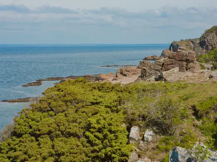
North to south, the Fishermen’s Trail starts around Sao Torpes / Porto Covo and the classic route ends at Odeceixe; the extended trail continues to Lagos via Cabo de Sao Vicente. Key coastal stops include Vila Nova de Milfontes, Almograve, Cavaleiro / Cabo Sardao and Zambujeira do Mar. The Historical Way starts at Santiago do Cacem, runs via Cercal do Alentejo, Sao Luis, Odemira and Saboia, with the classic core finishing at Odeceixe and extensions towards Cabo de Sao Vicente / Sagres. Both main routes are linear and signposted in both directions. At Vila Nova de Milfontes, walkers cross the Mira estuary by small ferry boat or road bridge. For the coast-only option, see the Fishermen's Trail; for another long-distance route in Portugal, compare the Caminho Portugues.
How the Rota Vicentina was created
The Rota Vicentina was created and waymarked by the Rota Vicentina association, founded around 2012–2013, to revive and connect old local paths. These routes were once used by fishermen walking to fishing grounds and by villagers travelling between settlements. The project was designed to support sustainable, slow tourism in southwest Portugal. The Historical Way was certified by the European Ramblers Association as a “Leading Quality Trails - Best of Europe” route in 2016 and 2020.
Notable highlights
- Cabo de Sao Vicente: The south-western tip of mainland Europe near Sagres, known for high Atlantic cliffs, a lighthouse and its historic “end of the known world” associations. It is a major landmark and terminus on the extended routes.
- Mira river crossing at Vila Nova de Milfontes: Walkers cross the wide Mira estuary by small ferry boat, or use the road bridge. It is one of the most distinctive transitions on the Fishermen’s Trail.
- Cliff-nesting white storks near Cabo Sardao / Cavaleiro: White storks nest directly on sea cliffs and rock stacks here. The exposed coastal walking makes this one of the trail’s most memorable wildlife sections.
- Cork oak forests: The Historical Way passes through cork oak montado, the traditional Alentejo landscape where cork is still harvested by hand. It gives the inland route a quieter, rural character.
- Zambujeira do Mar and Odeceixe: These whitewashed coastal villages and nearby beaches break up the southern coastal stages. Odeceixe is especially notable for its river-meets-Atlantic setting.
- Praia da Amalia / Carrapateira dunes: The southern Fishermen’s Trail includes wild beaches and shifting dunes. Expect soft sand and a more remote coastal feel.
Challenges to expect
The Fishermen’s Trail is the tougher half: 60–70% sandy trails, repeated cliff climbs and exposed edges make it physically demanding and unsuitable for hikers with vertigo or fear of heights. July and August are very hot, often over 30°C, and the Fishermen’s Trail booking season pauses. Navigation is helped by intuitive waymarking, but logistics are village-based: book guesthouses or rural lodgings, and note that wild camping is not permitted on the Fishermen’s Trail.
HikeList Score
Rota Vicentina (Fishermen's Trail and Historical Way) scored 81/100 on HikeList's trail-quality metrics.
See score breakdownHide breakdown
- Ideal length 75
- Balanced challenge 90
- Scenery & wildness 65
- Varied terrain 94
- Accommodation 83
- Food & support 81
- Path quality 98
- Season flexibility 89
Computed from length, challenge, scenery & wildness, terrain variety, accommodation, food & support, path quality and season flexibility.
 Portugal
Show more data Show less
- Coastal
- Cliffs
- Rural
- Cork Oak Forest
- Rolling Hills
- Valleys
- Sand
- Rural Tracks
- Trails
- Guesthouses
- Hotels
- Rural Lodgings
- Family Friendly
- Pet Friendly
- Restrooms
- Water Sources
- Campsites
Photos from hikers
Taken on the trail by people who've reviewed Rota Vicentina (Fishermen's Trail and Historical Way).
Reviews
How would you rate Rota Vicentina (Fishermen's Trail and Historical Way)?
Tap a star to start your review — you could be the first.