Rosenlaui Glacier Gorge Trail
How would you rate Rosenlaui Glacier Gorge Trail?
Tap a star to share your experience and help other hikers.
Rosenlaui Glacier Gorge Trail: Short Walk Through a Glacier Gorge
HikeList Score
Rosenlaui Glacier Gorge Trail scored 75/100 on HikeList's trail-quality metrics.
See score breakdownHide breakdown
- Ideal length 55
- Balanced challenge 100
- Scenery & wildness 71
- Varied terrain 89
- Accommodation 57
- Food & support 68
- Path quality 98
- Season flexibility 89
Computed from length, challenge, scenery & wildness, terrain variety, accommodation, food & support, path quality and season flexibility.
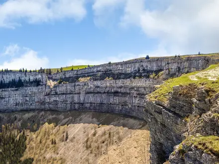
The Rosenlaui Glacier Gorge Trail is a 2 km, sub-hour, moderate day walk through the Gletscherschlucht Rosenlaui in the Bernese Oberland, Switzerland. This is not a long-distance trek: it is a managed visitor route with a ticket office, secured walkways, tunnels, footbridges and more than 200 steps. It suits families and casual hikers with sturdy shoes, provided they are comfortable with wet rock, spray, stairways and a short but steep climb beside glacier-fed water.
Route Overview
The walk starts and ends at the Rosenlaui glacier gorge car park and ticket office in Rosenlaui, in the Reichenbachtal near Meiringen. From the entrance, the secured path climbs through the narrow gorge on rock-cut sections, galleries, footbridges, two illuminated tunnels and stairways, gaining about 115 m. The return descends by a gravel path through mountain forest back to the ticket office, so the route feels more like a short circuit than a pure out-and-back. Access is normally via Meiringen; the B164 Postbus runs between Meiringen and Schwarzwaldalp from May to October. For bigger Swiss glacier walks, compare the Aletsch Glacier Panorama Trail or Diavolezza Glacier Trail.
History of the Rosenlaui Glacier Gorge
The Rosenlaui Glacier Gorge opened to the public on 6 June 1903. Creating the walkway was a major engineering job: blasting began on 28 October 1901, with around 9,000 dynamite charges used to cut the path through the limestone. The upper section had first been opened by local hotelier Kaspar Brog, and the route was extended to roughly its current length in the winter of 1930/31. The gorge is still inspected each spring before the visitor season opens.
Notable highlights
- The secured gorge walkway (573 m): Footbridges, galleries, tunnels and over 200 steps thread through polished rock beside loud glacier meltwater.
- Glacier pots and waterfalls: Meltwater from the Rosenlaui Glacier has carved smooth potholes, whirlpools and cascades into the gorge walls.
- Solar-lit tunnels: Two longer rock tunnels lead through the darkest, most enclosed parts of the gorge and are lit by solar-powered lighting.
- Wetterhorn and Wellhorn backdrop: The gorge sits below the Wetterhorn, Wellhorn, Engelhorner and Dossen, giving the short walk a strong Bernese Alps setting.
- Mountain forest return: The descent leaves the roar of the gorge for a mossy forest path back to the ticket office.
- Schwarzwaldalp sawmill: Up-valley at Schwarzwaldalp, a historic water-powered sawmill makes a worthwhile add-on if you continue along the valley road.
Challenges to expect
Expect a short but steep and wet route rather than a technical hike. The main challenges are over 200 steps, spray-slick rock, narrow enclosed sections and changing conditions in the gorge. Sturdy shoes are recommended. Navigation is simple and the path is secured, but opening hours can change in severe weather and the gorge is closed in winter. If you want a full multi-day route instead, look at the Alpine Pass Route or Bernina Trek.
HikeList Score
Rosenlaui Glacier Gorge Trail scored 75/100 on HikeList's trail-quality metrics.
See score breakdownHide breakdown
- Ideal length 55
- Balanced challenge 100
- Scenery & wildness 71
- Varied terrain 89
- Accommodation 57
- Food & support 68
- Path quality 98
- Season flexibility 89
Computed from length, challenge, scenery & wildness, terrain variety, accommodation, food & support, path quality and season flexibility.
Show more data Show less
- Gorge
- Mountain Forest
- Alpine Valley
- Rock Cut Path
- Footbridges
- Galleries
- Tunnels
- Steps
- Gravel
- Hotels
- Family Friendly
- Restrooms
- Picnic Areas
Photos from hikers
Taken on the trail by people who've reviewed Rosenlaui Glacier Gorge Trail.
Reviews
How would you rate Rosenlaui Glacier Gorge Trail?
Tap a star to start your review — you could be the first.