North Wales Path
How would you rate North Wales Path?
Tap a star to share your experience and help other hikers.
North Wales Path: Coast, Castles and Carneddau Foothills
HikeList Score
North Wales Path scored 90/100 on HikeList's trail-quality metrics.
See score breakdownHide breakdown
- Ideal length 89
- Balanced challenge 100
- Scenery & wildness 85
- Varied terrain 89
- Accommodation 91
- Food & support 88
- Path quality 92
- Season flexibility 89
Computed from length, challenge, scenery & wildness, terrain variety, accommodation, food & support, path quality and season flexibility.
The North Wales Path is a 97 km / 60 mile point-to-point hike across the north coast of Wales, linking Bangor in Gwynedd with Prestatyn in Denbighshire. Allow roughly 4–7 days; 5 days is a practical mid-range plan. Overall difficulty is moderate, but the western half is noticeably tougher, with moorland walking in the Carneddau foothills, while the eastern half uses gentler coastal and promenade sections. It suits walkers who want upland views, seaside towns and easy transport logistics.
Route Overview
The route can be walked either way, though many guidebooks describe it west-to-east from Bangor to Prestatyn. It passes Abergwyngregyn, Penmaenmawr, Conwy, Llandudno, Colwyn Bay, Abergele, Rhyl and Prestatyn, mixing public footpaths, old railway trackbed, seafront paths and exposed upland sections. The North Wales coast railway and bus routes run close to much of the trail, so it works well as a continuous point-to-point walk or as day walks from a fixed base. At Prestatyn it connects with the Offa’s Dyke Path, while coastal stretches overlap the Wales Coast Path. For nearby ideas, see the Aber Falls Walk or the Anglesey Coastal Path.
History of the North Wales Path
The North Wales Path was created in the 1990s as a waymarked long-distance route linking the North Wales coast resorts with the uplands behind them; a guidebook appeared in 1999. It largely follows pre-existing public footpaths and was devised and maintained by the former Countryside Council for Wales, now Natural Resources Wales, with Gwynedd, Conwy and Denbighshire councils. In many places it now overlaps with the later Wales Coast Path, and at Prestatyn it meets the Offa’s Dyke Path National Trail.
Notable highlights
- Aber Falls (Rhaeadr Fawr): A waterfall above Abergwyngregyn where the Afon Goch drops roughly 37 m over a cliff. The western stages climb onto open moorland close above it; for a shorter outing, see the Aber Falls Walk.
- Carneddau foothills: The strenuous western section traverses high moorland below Foel Fras, Foel Lwyd and Tal y Fan. Expect open views over the Menai Strait, Anglesey and Snowdonia.
- Conwy and its castle: The path passes through the medieval walled town of Conwy, dominated by Edward I’s 13th-century castle, a UNESCO World Heritage Site. It then climbs over Conwy Mountain, known locally as Mynydd y Dref.
- Sychnant Pass: A scenic pass between Conwy Mountain and Penmaenmawr, with heather moorland and broad coastal views. It is a useful transition between the upland and coastal character of the route.
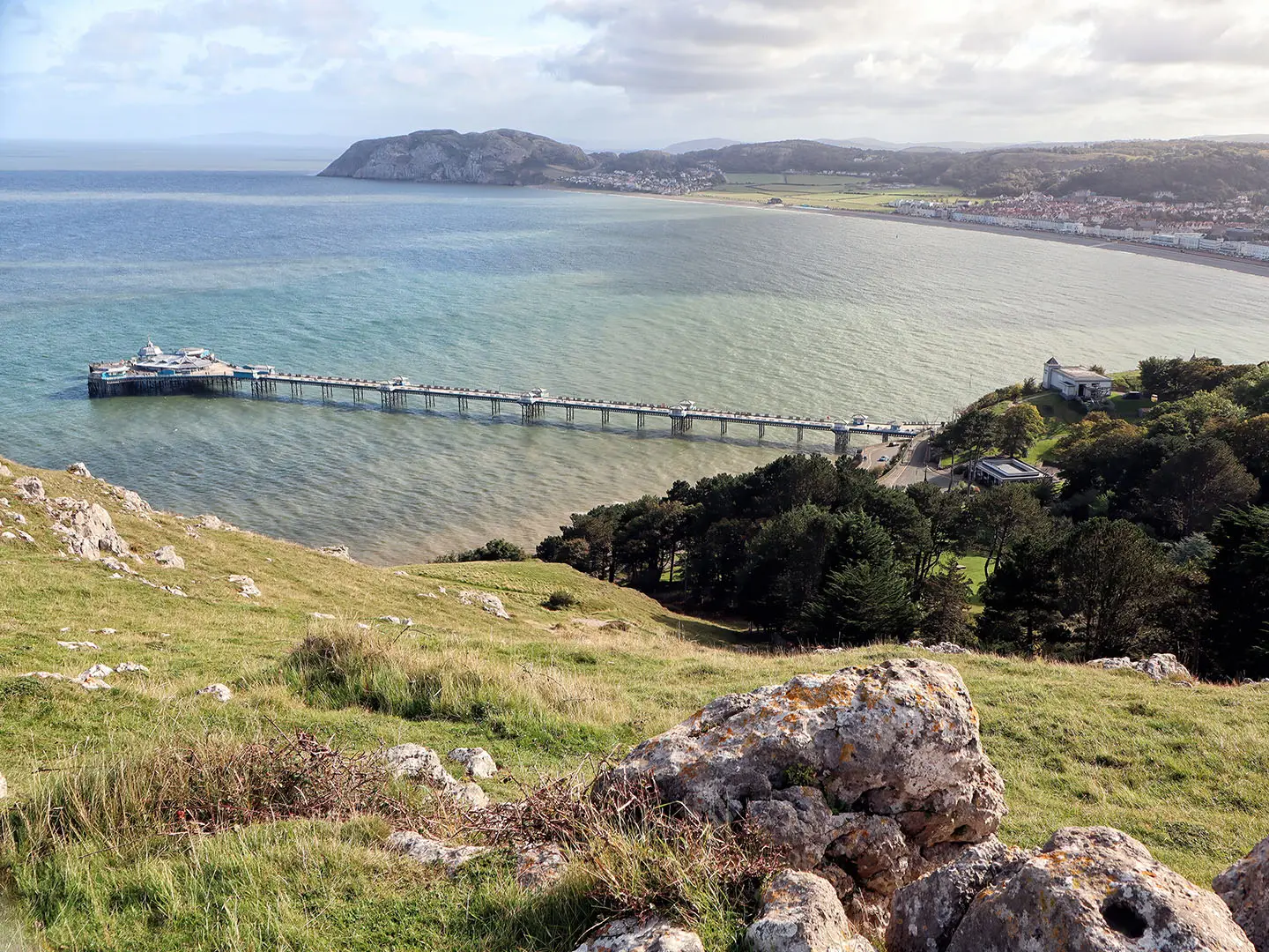
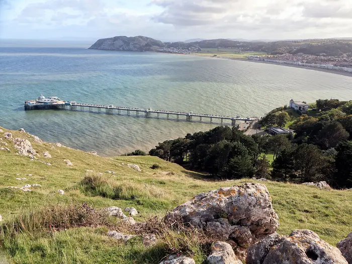
- Great Orme and Little Orme: These limestone headlands flank Llandudno. The Great Orme rises to about 207 m and is a Country Park known for wildflowers, seabirds and feral Kashmir goats.
- Wales Coast Path and Offa’s Dyke link: The route overlaps the Wales Coast Path along much of the coast and joins the Offa’s Dyke Path National Trail at Prestatyn.
Challenges to expect
The main difficulty is the contrast between sections. The Bangor end is more strenuous, with uneven moorland, upland exposure and around 2,300 m of total ascent across the full route. Mist, wind and wet ground can make the Carneddau foothills slow going, especially outside the main season. The eastern stages are easier underfoot, using flatter coastal promenades and seafront paths, with frequent towns for food, accommodation and transport.
HikeList Score
North Wales Path scored 90/100 on HikeList's trail-quality metrics.
See score breakdownHide breakdown
- Ideal length 89
- Balanced challenge 100
- Scenery & wildness 85
- Varied terrain 89
- Accommodation 91
- Food & support 88
- Path quality 92
- Season flexibility 89
Computed from length, challenge, scenery & wildness, terrain variety, accommodation, food & support, path quality and season flexibility.
Show more data Show less
- Moorland
- Upland
- Coastal
- Public Footpaths
- Surfaced Promenades
- Old Railway Trackbed
- Seafront Paths
- B&Bs
- Guesthouses
- Hotels
- Family Friendly
- Pet Friendly
- Restrooms
- Water Sources
- Campsites
- Picnic Areas
Download Our Full Guide to North Wales Path FREE!
Get our comprehensive guide to this hike for free. Save it for later reading or print out at home.
In these collections
Photos from hikers
Taken on the trail by people who've reviewed North Wales Path.
North Wales Path: The Complete Guide
 i
Image by Steve McHale
i
Image by Steve McHale The North Wales Path is a 60-mile / 97 km waymarked walk from Bangor to Prestatyn, linking the Menai Strait, the Carneddau foothills, Conwy, Llandudno and the north Wales coast. It suits walkers who want a route with real upland character but straightforward public transport and regular coastal towns.
Its western half is the demanding part: open moorland, rough tracks, steep ground and exposed walking below Tal y Fan and Foel Lwyd, with Aber Falls (Rhaeadr Fawr) and Conwy Mountain (Mynydd y Dref) among the key rewards. The path reaches about 395 m here, well above the easier seaside sections later on.
East of Conwy and the Great Orme (Y Gogarth), the character changes sharply. Promenades, seafront paths, field paths and the Prestatyn–Dyserth Way make the run towards Rhyl and Prestatyn much gentler underfoot.
This is not a technical trail, and the waymarking is a major advantage, but the western stages still need proper hill kit, weather judgement and enough flexibility for slow going in mist or boggy conditions. Accommodation is easiest in the coastal resort towns and thinner around the upland western section, so planning ahead matters.
This guide covers stages, walking days, accommodation, food, transport, terrain and the common mistakes to avoid.
Stage-by-Stage Guide
Distances below are approximate and should be used for planning rather than navigation. The North Wales Path is waymarked with its own hills-and-sea logo, but the western stages cross open, exposed ground where a map, compass and offline GPX are still important.
Stage 1: Bangor to Abergwyngregyn — 18 km
The opening stage leaves Bangor and heads east towards Abergwyngregyn (Aber), moving from city-edge walking into the more rural western half of the route. This is the beginning of the tougher side of the North Wales Path, so treat it as a hill-walking day rather than a coastal stroll.
Underfoot, expect a mixture of paths, tracks and field sections, with the ground becoming rougher and more open as the route approaches the Carneddau foothills. Conditions can be wet or slow after rain, and visibility can deteriorate quickly on higher or more exposed ground.
Abergwyngregyn is the key end-point for the day and the gateway to Aber Falls (Rhaeadr Fawr), where the Afon Goch drops about 37 m in the Carneddau foothills. The path crosses the bridge below the falls, with Rhaeadr Fach nearby, making this one of the main natural highlights of the whole route.
Food and water options should be treated as limited once away from Bangor. Carry a full day’s food and enough water, especially if walking outside the main season or arriving late in the day.
Accommodation is thinner here than in the coastal resort towns further east. Abergwyngregyn and the nearby western section should be booked ahead, with Llanfairfechan also a practical planning point on this part of the trail.
Bangor has a railway station on the North Wales Main Line, making the start straightforward by public transport. Local bus options for Abergwyngregyn and nearby villages should be checked before travelling.
Navigation is generally supported by waymarks, but this is not a stage to rely on waymarks alone. Take particular care where the route leaves built-up areas and where field or hill paths are less obvious.
Stage 2: Abergwyngregyn to Penmaenmawr — 12 km
This short-looking stage is one of the most serious days on the North Wales Path. It crosses the open Carneddau-foothills terrain below the higher summits of Foel Fras, Foel Lwyd and Tal y Fan, using an old Roman road through exposed upland country.
The route does not climb the named 600 m summits, but it still reaches the highest ground of the trail at about 395 m. Expect rough moorland paths, farm or hill tracks, steep gradients and sections that can be boggy, misty and slow.
The rewards are substantial in clear weather, with wide views towards the Menai Strait, Anglesey and the northern edge of Eryri (Snowdonia). The contrast between the high, open moor and the coast below is one of the defining features of the western half of the route.
There should be no assumption of reliable food or water between Abergwyngregyn and Penmaenmawr. Start with a full hill-day supply and do not plan around being able to resupply on the moorland section.
Penmaenmawr is a useful overnight halt on the coast below the Carneddau, but accommodation on this western stretch is less plentiful than in Conwy, Llandudno, Rhyl or Prestatyn. Book ahead, particularly at weekends and during the main walking season.
Public transport options along this coastal corridor are generally good compared with many upland routes, but specific bus or rail times for Penmaenmawr should be checked before travelling. Road access is better at the coastal settlements than on the moorland crossing itself.
This is the stage where poor visibility matters most. Carry proper waterproofs, warm layers, map, compass and offline navigation; in mist, the old-track lines and open moor can be disorientating even though the route is waymarked.
Stage 3: Penmaenmawr to Conwy — 10 km
This is another comparatively short stage, but it still belongs to the hillier western half of the North Wales Path. From Penmaenmawr the route works through upland and fringe-country towards Dwygyfylchi, Sychnant Pass (Bwlch Sychnant) and Conwy Mountain (Mynydd y Dref) before dropping towards Conwy.
Sychnant Pass marks a clear transition in the route: steep, heather-clad ground between Penmaenmawr and Conwy Mountain before the trail begins to feel closer to the coast and the settlements. The terrain remains rougher than the later promenade stages, with steep ascents and descents that can be slippery in wet weather.
Conwy Mountain is a major highlight, with heathery slopes, views over the estuary and the Iron Age hillfort of Castell Caer Seion. The descent towards Conwy brings the route into one of the most historically distinctive towns on the trail.
Conwy is the first major service hub after the western upland stages. Food, drink and accommodation options are much stronger here than at the smaller western stops, though booking ahead is still sensible in busy periods.
Conwy has a railway station on the North Wales Main Line, and nearby Llandudno Junction is also on the line. This makes Conwy a practical place to start, finish or split the walk if the western stages need to be shortened.
Navigation across Sychnant Pass and Conwy Mountain still needs hill-walking attention, especially in low cloud or strong wind. Once descending into Conwy, the route passes close to the walled town and Conwy Castle, part of the UNESCO-listed Castles and Town Walls of King Edward in Gwynedd.
Stage 4: Conwy to Llandudno — 13 km
This stage links two of the best-served towns on the route and begins the shift into easier coastal walking. It is less remote than the previous stages, but it still includes headland and hillside walking rather than being a purely flat seafront day.
The route leaves the Conwy area and heads towards Llandudno, with the Great Orme (Y Gogarth) forming the major landscape feature above the town. The Great Orme rises to 207 m and is a Country Park and SSSI known for limestone habitat, wildflowers, seabirds and feral Kashmir goats.
Underfoot, expect a mixed day: paths and tracks around the Conwy and Llandudno side of the route, then easier surfaces as the trail approaches the resort. Compared with the Carneddau-foothills stages, navigation is less exposed, but do not underestimate wind and weather around the headland.
Conwy is a strong place to stock up before setting off, and Llandudno has plentiful food, drink and accommodation. This is one of the easiest overnight logistics on the North Wales Path.
Both Conwy and Llandudno are useful public-transport points, with Conwy on the North Wales Main Line and Llandudno on a short branch. This stage is therefore a good candidate for a day walk or for joining the trail mid-route.
Waymarking should be straightforward through the more populated sections, but take care where the North Wales Path overlaps or runs near other signed coastal routes. The North Wales Path is a separate, older route from the Wales Coast Path, even where the two share ground along the coast.
Stage 5: Llandudno to Llanddulas / Abergele — 17 km
This is the first full eastern-coastal stage and feels very different from the moorland west of Conwy. The walking is generally easier underfoot, using promenades, seafront paths, pavement and field paths as the route continues along the coast.
From Llandudno the trail passes between the resort setting and the limestone headlands of the Great Orme (Y Gogarth) and Little Orme (Rhiwledyn). Little Orme gives further sea views and is known for nesting seabirds, while the route then continues through or near Rhos-on-Sea (Llandrillo-yn-Rhos), Colwyn Bay (Bae Colwyn), Llysfaen and towards Llanddulas / Abergele.
Services are much more frequent than on the western upland days. Llandudno, Rhos-on-Sea and Colwyn Bay are practical places for food and drink, but carry water between towns rather than assuming every seafront section will have open facilities year-round.
Accommodation is plentiful in the larger coastal resort towns, particularly Llandudno and Colwyn Bay. At the Llanddulas / Abergele end, check exact accommodation location against the route before booking, as using Abergele or Pensarn may be more practical for transport.
Colwyn Bay and Abergele & Pensarn are on the North Wales Main Line, and Llandudno has rail access on its branch line. This makes the stage easy to shorten, split or use as a day walk from a fixed base.
Navigation is usually simple, but the main issue is choosing the correct signed route where several coastal paths, promenades and local paths meet. In built-up areas, watch for waymark discs at junctions rather than simply following the nearest seafront.
Stage 6: Llanddulas / Abergele to Rhyl — 13 km
This is an easier coastal stage, with the upland character now largely behind the route. The walking uses a mixture of seafront paths, pavement and low-level routes through the coastal corridor towards Rhyl (Y Rhyl).
The main places associated with this section are Llanddulas, Abergele, Pensarn and Rhyl. The day is less about height gain and more about steady progress along the coast, with straightforward surfaces and frequent access points.
Food and drink are easier to manage than in the western half, especially around Abergele, Pensarn and Rhyl. Even so, carry enough water for the whole stage if walking early, late or outside the main visitor season, when some seafront facilities may be closed.
Rhyl has a wide range of accommodation for an overnight stop and is one of the easier places on the trail to arrange transport or restart the next day. It is a practical staging point before the final run to Prestatyn.
Abergele & Pensarn and Rhyl are both on the North Wales Main Line. This makes the section straightforward to access by train, and it can be combined with Stage 7 by fit walkers wanting a longer final coastal day.
Navigation is usually uncomplicated, but pay attention where the route leaves promenades or shared coastal paths for field or inland sections. The main walking warning is exposure to wind and weather on open seafront stretches rather than difficult terrain.
Stage 7: Rhyl to Prestatyn — 14 km
The final stage continues east from Rhyl (Y Rhyl) to Prestatyn, finishing where the North Wales Path meets the northern end of the Offa's Dyke Path National Trail. This is a relatively gentle end to the route compared with the Carneddau-foothills crossing at the start.
The terrain is low-level and generally easy, using coastal and inland paths, including the Prestatyn–Dyserth Way near the finish. This former railway trackbed gives a straightforward traffic-free approach towards Prestatyn.
Dyserth lies near the route, while Prestatyn provides the clear end-point and the link to the longer Offa's Dyke Path. The finish at the coast is logistically convenient, with good onward transport compared with many long-distance trail termini.
Food and drink are available at the larger towns, especially Rhyl and Prestatyn, but carry enough for the walking day. Do not rely on facilities along every intermediate section being open, particularly out of season.
Prestatyn has a railway station on the North Wales Main Line, making the finish easy to leave by public transport. Rhyl is also on the same line, so the final stage works well as a standalone day walk.
Navigation is generally easy, but the usual caution applies where the North Wales Path shares space with other local routes and coastal paths. Follow the North Wales Path waymarks to avoid drifting onto a parallel promenade or cycle route, and note that the Offa's Dyke Path connection is at Prestatyn rather than before it.
Recommended Itinerary
The safest default plan for the North Wales Path is to give the western half enough time. The Bangor to Conwy section is shorter on paper than the coast, but it contains the exposed Carneddau-foothills walking, the high point of the route and slower ground; the eastern half can be compressed more easily because it follows easier coastal paths, promenades and the Prestatyn–Dyserth Way near the finish.
Distances below are approximate and should be checked against official mapping before booking accommodation, especially if combining stages.
Standard itinerary – 7 walking days
| Day | From | To | Approx. distance | Why this stage makes sense | Services/accommodation notes |
|---|---|---|---|---|---|
| 1 | Bangor | Abergwyngregyn (Aber) | 18 km | A substantial first day without forcing the highest, most exposed moorland into the same stage. It positions you well for the Carneddau-foothills crossing and Aber Falls (Rhaeadr Fawr). | Bangor has strong rail access and a good choice of places to stay. Accommodation is thinner around Abergwyngregyn, so book ahead or check current bus options before relying on it as an overnight stop. |
| 2 | Abergwyngregyn (Aber) | Penmaenmawr | 12 km | Short in distance but one of the key hill days, crossing exposed ground on the Carneddau foothills below Tal y Fan and Foel Lwyd, with the route high point at about 395 m. The path does not summit the named 600 m peaks. | Keep this day deliberately short if the weather is poor. Llanfairfechan is a practical alternative stopping point on this western stretch, but accommodation and onward transport should be checked before travelling. |
| 3 | Penmaenmawr | Conwy | 10 km | Another short stage, but it includes the Sychnant Pass (Bwlch Sychnant) and Conwy Mountain (Mynydd y Dref) area before reaching the walled town. This avoids rushing the final upland section. | Conwy is one of the best overnight stops on the route, with accommodation, food and rail access. It is also a sensible place to pause if weather has slowed progress in the western hills. |
| 4 | Conwy | Llandudno | 13 km | A manageable link between two major service centres, with time to see Conwy Castle and the town walls before moving on to the Llandudno section. It also sets up the easier coastal half. | Both Conwy and Llandudno have good accommodation options. Llandudno is on a short rail branch, with wider main-line connections via the North Wales coast. |
| 5 | Llandudno | Llanddulas / Abergele | 17 km | This is the first longer coastal-resort stage, taking in the easier eastern character of the path, with the Great Orme (Y Gogarth), Little Orme (Rhiwledyn), Rhos-on-Sea (Llandrillo-yn-Rhos), Colwyn Bay (Bae Colwyn) and Llysfaen lying on this section of the route sequence. | Accommodation is generally easier to find in the coastal towns than in the western hills. Choose between Llanddulas and Abergele according to available beds and onward transport; Abergele & Pensarn is on the North Wales Main Line. |
| 6 | Llanddulas / Abergele | Rhyl (Y Rhyl) | 13 km | A relatively straightforward coastal day after the hillier western stages. Keeping it separate prevents the final two days becoming one long road-and-seafront push. | Rhyl is a large coastal town with rail access and a range of services. This is a useful bail-out or regrouping point if walking in mixed weather. |
| 7 | Rhyl (Y Rhyl) | Prestatyn | 14 km | A clean final stage into Prestatyn, using easy ground including the Prestatyn–Dyserth Way near the eastern end. The route finishes where it links with the Offa’s Dyke Path National Trail. | Prestatyn has its own station and accommodation. If connecting onward by train, check current services before committing to a late finish. |
Slower option – 8 days or more
A slower itinerary suits walkers carrying heavier packs, anyone uncertain about exposed upland conditions, and groups who want time for Conwy, Llandudno or the Ormes rather than treating them as pass-through points.
The most useful way to slow the route is to protect the western half. Keep Bangor to Abergwyngregyn, Abergwyngregyn to Penmaenmawr, and Penmaenmawr to Conwy as separate walking days, then add a spare night around Conwy or Llandudno. Llanfairfechan can also work as an alternative or additional stop on the Bangor–Penmaenmawr stretch, but exact stage distances and accommodation availability should be checked before booking.
The coastal half is easier to day-walk from a fixed base because the North Wales Main Line runs close to the route, with stations including Conwy, Colwyn Bay, Abergele & Pensarn, Rhyl and Prestatyn, plus the Llandudno branch. Current train and bus times should be checked before travelling.
Faster option – 5 to 6 days
A faster itinerary is best for fit walkers with light packs who are comfortable combining shorter stages. It is usually more sensible to compress the eastern coastal half than the Carneddau-foothills section, because the western days are more exposed and slower underfoot.
| Option | Pattern | Who it suits | Main caution |
|---|---|---|---|
| 6 days | Follow the 7-day itinerary to Llanddulas / Abergele, then combine Llanddulas / Abergele to Rhyl and Rhyl to Prestatyn into one final day of about 27 km. | Walkers who want a steady hill schedule in the west but are happy with one longer coastal day. | The final day is long even if the terrain is easier; check transport from Prestatyn before committing to a late arrival. |
| 5 days | Bangor to Abergwyngregyn; Abergwyngregyn to Conwy, about 22 km; Conwy to Llandudno; Llandudno to Rhyl, about 30 km; Rhyl to Prestatyn. | Strong walkers who can handle one long upland-linked day and one long coastal day. | Abergwyngregyn to Conwy combines two of the more demanding western stages, while Llandudno to Rhyl is a long day despite easier surfaces. This is not the best plan in poor hill weather. |
A 4-day crossing leaves very little margin on the western half and is only appropriate for walkers already used to long hill days. For most independent hikers, 6 or 7 days gives a much better balance between distance, weather flexibility and accommodation logistics.
Planning the Route
How many days to allow
Most walkers should plan the North Wales Path as a 5–6 day walk unless deliberately moving fast or using it as a series of day walks. The key point is that the route should not be divided purely by distance: the western half from Bangor through Abergwyngregyn (Aber), Llanfairfechan, Penmaenmawr, Sychnant Pass (Bwlch Sychnant) and Conwy is slower, rougher and more exposed than the coast east of Llandudno.
A 4-day itinerary is realistic only for fit walkers who are comfortable with long days and upland conditions. A 7-day itinerary gives a much easier pace and suits walkers who want shorter days, more time around Conwy, Llandudno and the Ormes, or a more relaxed coastal finish.
Bangor to Prestatyn is the usual direction in guidebooks and has the advantage of putting the hardest walking early. Walking east-to-west is equally possible because the route is waymarked both ways, but it means the final stages build into the more strenuous Carneddau-foothills terrain.
Practical stage planning
The route has natural overnight points, but accommodation is not evenly spread. The coastal towns and resorts are much easier for beds, food and transport; the western upland section needs more care, especially around Abergwyngregyn (Aber), Llanfairfechan and Penmaenmawr.
A sensible 7-day breakdown is:
| Stage | From | To | Approx. distance | Planning note |
|---|---|---|---|---|
| 1 | Bangor | Abergwyngregyn (Aber) | 18 km | First upland-feeling day; do not treat it as an easy coastal opener. |
| 2 | Abergwyngregyn (Aber) | Penmaenmawr | 12 km | Short on paper, but the Carneddau-foothills crossing can be slow in poor weather. |
| 3 | Penmaenmawr | Conwy | 10 km | Crosses the Sychnant Pass (Bwlch Sychnant) and Conwy Mountain (Mynydd y Dref). |
| 4 | Conwy | Llandudno | 13 km | Transition into the resort/coastal half, with easier logistics. |
| 5 | Llandudno | Llanddulas / Abergele | 17 km | Coastal walking via the Ormes, Rhos-on-Sea and Colwyn Bay (Bae Colwyn). |
| 6 | Llanddulas / Abergele | Rhyl (Y Rhyl) | 13 km | Easier underfoot, with coastal services nearby. |
| 7 | Rhyl (Y Rhyl) | Prestatyn | 14 km | Final approach using easier paths, including the Prestatyn–Dyserth Way near the finish. |
For a 5-day plan, combine some of the shorter eastern coastal days rather than forcing long upland stages in the west. The western half deserves conservative planning because ascent, boggy ground, mist and exposure can all slow progress.
Accommodation and resupply
Book the western half first. Bangor, Conwy, Llandudno, Colwyn Bay (Bae Colwyn), Rhyl (Y Rhyl) and Prestatyn have far more accommodation choice than the smaller places between Bangor and Conwy, while the upland fringe around Abergwyngregyn (Aber), Llanfairfechan and Penmaenmawr is thinner and should be planned ahead.
Food planning is straightforward on the coast but more important before the Carneddau-foothills stages. Start the western days with enough food and water for a full hill day, rather than relying on finding regular services on the moorland sections. Current opening times for shops, pubs and cafés should be checked before travelling, especially outside the main summer season.
Transport and section hiking
This is one of the easier Welsh long-distance paths to section-hike. The North Wales Main Line runs close to the trail for much of its length, with stations at Bangor and Prestatyn and useful rail access at places including Conwy, Colwyn Bay, Abergele & Pensarn, Rhyl and Llandudno Junction; Llandudno is on a short branch.
That rail access makes several approaches practical: walking the whole route point-to-point, basing yourself in one coastal town for day walks, or splitting the trail into western upland and eastern coastal weekends. Buses, including coastal and valley services in Conwy, help fill gaps, but current train and bus times should be checked before travelling.
The eastern half is the easiest part to shorten at short notice because the railway and coastal settlements stay close. The western half has fewer simple escape points once committed to the moorland crossing, so weather and daylight matter more there.
Navigation and mapping
The North Wales Path is waymarked with its own stylised hills-and-sea logo, but the western half should still be treated as proper hill navigation. Mist on the Carneddau foothills, rough tracks, boggy ground and exposed moorland make a map, compass and/or reliable offline GPS essential.
Useful Ordnance Survey mapping includes Explorer OL17, Explorer 263, 264 and 265, and Landranger 114, 115 and 116. Conwy Council recommends OL17 and 264 for the route. Carry mapping that covers the full day, not just the coast, and check for current diversions before setting off.
Take care not to confuse the North Wales Path with the Wales Coast Path. They overlap along parts of the coastal half, but the North Wales Path is the older Bangor–Prestatyn route that deliberately goes inland over the Carneddau foothills and Conwy Mountain before returning to the coast.
Weather and timing
Spring, summer and autumn are the normal seasons for planning this route. The coast can feel benign, but the western section reaches exposed moorland at about 395 m below the higher summits of Tal y Fan and Foel Lwyd, so wind, low cloud and rain can change the character of a day quickly.
Build flexibility around the Bangor to Conwy half if possible. In poor visibility, the old Roman road and open moorland above Abergwyngregyn (Aber) and the crossing towards Penmaenmawr require more care than the later promenades and seafront paths.
Extending the walk
Prestatyn is a natural finish because the North Wales Path meets the northern end of the Offa’s Dyke Path National Trail there. Walkers wanting a longer journey can continue onto Offa’s Dyke from Prestatyn, but this changes the character of the trip completely and should be planned as a separate long-distance route.
Towns, Villages and Overnight Stops
Overnight planning is easiest from Conwy eastwards, where the route stays close to the coast and larger resort towns. The western half between Bangor, Abergwyngregyn (Aber), Llanfairfechan, Penmaenmawr and Conwy is more committing: accommodation and food options are thinner, the walking is more exposed, and small-place availability should be checked before travelling.
For a first end-to-end itinerary, the most practical overnight hubs are usually Bangor, Abergwyngregyn (Aber) or Llanfairfechan, Penmaenmawr, Conwy, Llandudno, Llanddulas / Abergele, Rhyl and Prestatyn. The North Wales Main Line and local buses make it possible to adjust stages, but current timetables should be checked before booking accommodation around them.
Bangor
Bangor is the standard western start for the North Wales Path and a sensible place to stay the night before beginning the route. It has its own railway station and is the last substantial service centre before the first, tougher west-to-east day across the lower Carneddau side of the route.
Use Bangor to start with food, water and any missing hill kit already sorted. The next section towards Abergwyngregyn (Aber) is not the place to discover that waterproofs, navigation or a packed lunch are inadequate.
Abergwyngregyn (Aber)
Abergwyngregyn, often shortened to Aber, sits below the Carneddau foothills and is a natural stopping point after the first west-to-east stage from Bangor. It is also the access village for Aber Falls (Rhaeadr Fawr), where the route crosses below the waterfall.
This is a useful overnight stop if splitting the western upland section into manageable days, but it is not a large resort town. Accommodation, evening meals and any food supplies should be arranged in advance rather than assumed on arrival.
Llanfairfechan
Llanfairfechan is on the coast between Abergwyngregyn (Aber) and Penmaenmawr and is a practical alternative stage break on the western half. Some walkers use it instead of Abergwyngregyn or Penmaenmawr to make the early days fit accommodation availability.
It works well as a planning buffer because the route is still close to the North Wales coastal transport corridor. Exact rail and bus options, and the location of accommodation relative to the path, should be checked before travelling.
Penmaenmawr
Penmaenmawr is a key western-half overnight stop below the Carneddau foothills, commonly used before or after the crossing towards Sychnant Pass (Bwlch Sychnant) and Conwy Mountain (Mynydd y Dref). It is a former quarrying town, with the prehistoric Druids' Circle (Meini Hirion) on the moor above.
For walkers heading west to east, Penmaenmawr is a useful place to regroup before the climb towards Dwygyfylchi, Sychnant Pass and Conwy. Accommodation and food options are less plentiful here than in the larger coastal resort towns, so book ahead and do not rely on last-minute availability.
Dwygyfylchi
Dwygyfylchi lies between Penmaenmawr and Sychnant Pass (Bwlch Sychnant), at the foot of the higher ground leading towards Conwy. It is more of a route waypoint than a primary overnight hub.
It can be useful for access, pick-ups or adjusting a day, but walkers should not assume a full range of hiker services here. If planning to end a stage around Dwygyfylchi, check accommodation, food and onward transport before committing.
Sychnant Pass (Bwlch Sychnant)
Sychnant Pass is a high-level transition point between the upland western half and the descent towards Conwy. It is not an overnight stop or a resupply point.
Plan to cross it as part of a day between Penmaenmawr, Dwygyfylchi and Conwy, with enough food, water and weather protection already carried. In poor visibility or rough weather, this section should be treated as hillwalking rather than coastal strolling.
Conwy
Conwy is one of the best overnight stops on the route. It sits at the end of the western upland section for many walkers and has plentiful accommodation compared with the smaller settlements to the west.
The town has a railway station and strong onward transport links via the North Wales coastal corridor, with Llandudno Junction also nearby on the main line. It is a good place to reset the itinerary, take a shorter day after the tougher Carneddau and Conwy Mountain sections, or restart as a section walker.
Conwy is also a practical food and services stop before the route turns towards Llandudno and the Great Orme (Y Gogarth). The path passes the walled town and Conwy Castle area, so accommodation close to the centre is usually convenient for rejoining the trail.
Conwy Mountain (Mynydd y Dref)
Conwy Mountain is a route feature rather than an overnight stop. The path crosses this heathery hill above Conwy, passing the Iron Age hillfort of Castell Caer Seion and giving views over the estuary.
There are no planning advantages in treating it as a stop. Carry what is needed from Penmaenmawr or Conwy, depending on direction, and allow for exposed conditions despite the hill's proximity to town.
Llandudno
Llandudno is one of the strongest overnight bases on the North Wales Path. It has plentiful accommodation, sits on a short railway branch from the North Wales Main Line, and makes an obvious stop between the Conwy / Great Orme section and the easier coastal walking eastwards.
This is a good place for a rest night, laundry, resupply and itinerary adjustment. Walkers who only want the gentler eastern half can also use Llandudno as a practical starting point, provided transport to the route is planned in advance.
Great Orme (Y Gogarth)
The Great Orme is the limestone headland above Llandudno, rising to about 207 m. The North Wales Path skirts it as part of the Llandudno section.
It is not a separate overnight stop for most walkers; Llandudno is the practical base. Treat the headland as a walking section where weather can still matter, then use the town for accommodation, food and transport.
Little Orme (Rhiwledyn)
Little Orme lies on the eastern side of Llandudno Bay and is another route feature rather than a services hub. It is useful mainly as a landmark on the transition from Llandudno towards Rhos-on-Sea and Colwyn Bay.
Do not plan around Little Orme for accommodation or resupply. Llandudno and Colwyn Bay are the more practical bases on either side.
Rhos-on-Sea (Llandrillo-yn-Rhos)
Rhos-on-Sea sits on the coastal section between Llandudno and Colwyn Bay. It can work as a pause or short-stage point on the easier eastern half, especially for walkers taking a relaxed pace along the seafront.
For overnight planning, nearby Llandudno and Colwyn Bay are the stronger confirmed hubs. If using Rhos-on-Sea as a stop, check accommodation, evening food and transport before booking the stage around it.
Colwyn Bay (Bae Colwyn)
Colwyn Bay is a major practical stop on the eastern half of the route. It has plentiful accommodation relative to the smaller settlements, and Colwyn Bay station is on the North Wales Main Line.
This is a good place to stay if splitting the Llandudno to Llanddulas / Abergele stretch into shorter days. It is also useful for section walkers, because the railway makes it straightforward to leave or rejoin the route without committing to the full end-to-end walk.
Llysfaen
Llysfaen is an inland route point east of Colwyn Bay and before Llanddulas. It is not one of the main accommodation hubs on the path.
Use it as a navigation and stage-planning marker rather than a guaranteed services stop. If a route plan depends on stopping here, accommodation, food and transport should be checked before travelling.
Llanddulas
Llanddulas is a practical stage-end option on the eastern half, often paired in planning with Abergele. It sits between Colwyn Bay and the Abergele / Pensarn area.
It may suit walkers who want to keep the coastal stages shorter, but it should not be assumed to offer the same range of accommodation as Llandudno, Colwyn Bay, Rhyl or Prestatyn. Check where any booked accommodation sits in relation to the path, as small detours can matter at the end of a day.
Abergele
Abergele is one of the more useful overnight choices between Colwyn Bay and Rhyl, particularly when linked with nearby Pensarn. Abergele & Pensarn station is on the North Wales Main Line, making this area useful for both end-to-end walkers and section hikers.
It works well as a break before the final coastal run towards Rhyl and Prestatyn. Accommodation and food should still be checked before travelling, especially outside busy holiday periods or if arriving late in the day.
Pensarn
Pensarn is closely linked with Abergele for route-planning purposes, and Abergele & Pensarn station gives this part of the walk a useful rail access point. It is a sensible place to consider when arranging a shorter day between Llanddulas / Abergele and Rhyl.
For overnight logistics, treat Pensarn and Abergele together and choose accommodation based on proximity to the route and station. Do not assume that every option will be directly on the path.
Rhyl (Y Rhyl)
Rhyl is a strong overnight stop near the eastern end of the North Wales Path. It has plentiful accommodation and its own railway station on the North Wales Main Line.
For west-to-east walkers, Rhyl is a practical final-night base before the run-in to Prestatyn. It is also useful for section walking, as the rail access makes it easy to shorten or rearrange the last part of the route.
Dyserth
Dyserth sits near the route close to the eastern end, associated with the Prestatyn–Dyserth Way, a former railway trackbed used on the approach to Prestatyn. It is best treated as a nearby waypoint rather than a core overnight stop.
The main practical value is for access, short walks and understanding the final approach to Prestatyn. If planning to leave the route or stay around Dyserth, check current transport and accommodation before relying on it.
Prestatyn
Prestatyn is the eastern finish of the North Wales Path and the point where it meets the northern terminus of the Offa's Dyke Path National Trail. It has its own railway station and plentiful accommodation, making it a straightforward place to finish, stay overnight or connect to onward travel.
Walkers continuing onto Offa's Dyke Path should plan Prestatyn as a proper resupply and recovery stop rather than simply a finish marker. Those ending the North Wales Path here should still check train times before travelling, especially if finishing late in the day.
Getting to the Start
By train
Bangor has its own railway station and is the normal public-transport gateway for starting the North Wales Path west-to-east. It sits on the North Wales Main Line, the Crewe–Holyhead railway, which also serves many points along or near the route.
For most walkers arriving from elsewhere in the UK, the simplest plan is to route onto the North Wales Coast railway and travel to Bangor by train. This also makes the end-to-end logistics straightforward: Prestatyn, the finish, is on the same rail corridor, so you can return along the coast by train after completing the walk.
If breaking the route into day walks or shorter sections, the same line is useful throughout the trail. Stations on or near the route include Conwy, Colwyn Bay, Abergele & Pensarn, Rhyl, Prestatyn and Llandudno Junction, with Llandudno on a short branch. Current train times and engineering work should be checked before travelling.
By bus
Bus travel is useful for filling gaps between railway stations, accommodation and trailheads, especially where the route moves inland or onto the western upland section. Conwy’s coastal and valley services are particularly relevant once the walk is under way.
For reaching the start itself, Bangor by train is usually the cleaner option unless travelling from somewhere local. If using buses to reach Bangor, Abergwyngregyn (Aber), Llanfairfechan or another nearby overnight stop before day one, check current timetables carefully before committing accommodation or baggage plans. This should be checked before travelling.
By car
Driving to Bangor is possible, but the North Wales Path is a point-to-point walk, so parking needs more thought than on a circular route. The easiest car-based plan is often to park at or near pre-walk accommodation in Bangor, walk to Prestatyn, then use the North Wales Coast railway to return.
Do not assume long-stay parking will be available exactly where the route begins. Parking rules, charges and overnight restrictions in Bangor should be checked before travelling, and any arrangement with accommodation should be agreed in advance.
If being dropped off, Bangor is the most convenient starting point. Taxis can also help with short local transfers to accommodation or to a different start point, but availability and fares should be checked locally, especially for early starts or evening arrivals.
From the nearest airport
Air travel is rarely the key logistical issue for this route; the practical gateway is the North Wales Coast railway. If flying in, choose an airport with a workable rail connection onto the Crewe–Holyhead line, then continue by train to Bangor.
Airport rail connections, late-evening arrivals and Sunday services can affect the viability of starting the next morning. This should be checked before travelling.
Where to stay before starting
Bangor is the most straightforward place to stay before beginning the North Wales Path. It gives direct access to the start and avoids needing a morning transfer before the first walking day.
Accommodation becomes thinner on the western upland half than in the coastal resort towns later on the route. If planning a first night at Abergwyngregyn (Aber), Llanfairfechan or Penmaenmawr rather than in Bangor, book ahead and check how you will reach the property from the trail.
A late arrival is best handled by staying in Bangor and starting fresh the next morning. The first western stages include exposed moorland and rougher upland walking, so they are not ideal for squeezing in after a long journey.
Getting Home from the Finish
By train
Prestatyn has its own railway station, making the finish one of the easier long-distance trail exits in Wales. The station is on the North Wales Main Line, the Crewe–Holyhead “North Wales Coast” railway, which also serves Bangor at the start of the route and several useful intermediate trail towns.
For most walkers, the train is the simplest way to leave Prestatyn. It gives direct or connecting options back along the coast towards Rhyl (Y Rhyl), Abergele & Pensarn, Colwyn Bay (Bae Colwyn), Llandudno Junction, Conwy and Bangor, as well as onward main-line travel via Crewe or Holyhead.
If a car has been left at Bangor, returning by rail from Prestatyn is usually the most practical plan. If accommodation has been booked elsewhere on the coast for the final night, nearby stations such as Rhyl, Abergele & Pensarn, Colwyn Bay and Llandudno Junction can also be useful.
Train times, last services and engineering works should be checked before travelling, especially if finishing late in the day or walking the final Rhyl–Prestatyn stage in poor weather.
By bus
Buses can be useful for short local moves from Prestatyn, particularly if staying away from the station or linking to nearby coastal towns. The wider route is well served by coastal and valley bus services, but buses are more timetable-sensitive than the railway for getting home from the finish.
Use the train as the default exit unless a bus clearly fits the final accommodation or onward plan. Evening and Sunday services should be checked before relying on them.
By car/taxi
The North Wales Path is a point-to-point route, so car logistics need planning in advance. If using one vehicle, the cleanest option is often to leave it at the start or finish and use the North Wales Main Line to make the return journey between Bangor and Prestatyn.
If leaving a vehicle in Prestatyn, check current parking rules and any overnight restrictions before setting out. If leaving a vehicle in Bangor, the rail journey back from Prestatyn avoids a long end-of-walk taxi.
Taxis are useful for short local transfers at the finish, for example to accommodation in Prestatyn or nearby coastal towns. A taxi for the full route back towards Bangor would be a long and potentially expensive journey, so it should be arranged in advance if needed. Late-day finishers should pre-book rather than assume immediate availability.
From the nearest airport
Most walkers will leave the North Wales Path by rail rather than by air. Prestatyn’s position on the North Wales Main Line makes onward airport travel a rail-first journey, usually involving changes onto wider UK rail or coach networks.
Specific airport routes, journey times and late connections depend on the chosen airport and should be checked before travelling. If flying out the same day, build in a generous buffer after the final stage, as the last section from Rhyl (Y Rhyl) to Prestatyn still needs completing before any onward transport.
Where to stay at the finish
Prestatyn is a practical place to stop at the end of the walk, with accommodation in the town and more options along the nearby resort coast. Rhyl (Y Rhyl) is also close by and has its own station on the same rail line.
Staying overnight at the finish is sensible if the final day ends late, if onward trains are limited, or if continuing onto the Offa’s Dyke Path, which starts from Prestatyn. It also removes pressure from the final stage and gives a safer fallback if weather, fatigue or delays slow the approach from Rhyl.
Which Direction Should You Walk?
The North Wales Path is normally described west to east, from Bangor to Prestatyn. Most guidebooks and the LDWA use this direction, and it gives the route a clear finish at Prestatyn, where it meets the northern end of the Offa's Dyke Path National Trail.
The route is waymarked in both directions, so walking east to west from Prestatyn to Bangor is perfectly practical. Direction choice is more about day structure, accommodation and how you want the difficulty to unfold than about navigation.
| Direction | Best for | Main trade-off |
|---|---|---|
| Bangor to Prestatyn | The standard direction, harder walking first, easier coastal finish, Offa's Dyke link at the end | The exposed Carneddau-foothills section comes early, so you need to be hill-ready from day one |
| Prestatyn to Bangor | A gentler start on coastal paths and promenades, building towards the upland western half | The toughest and most weather-exposed walking comes late in the trip |
Bangor to Prestatyn: the standard direction
Walking west to east puts the demanding half of the route first. From Bangor, the route heads towards Abergwyngregyn (Aber), the Carneddau foothills, Penmaenmawr, Sychnant Pass (Bwlch Sychnant) and Conwy Mountain (Mynydd y Dref), where the walking is higher, rougher and more exposed.
This is a good direction if you prefer to tackle the strenuous ground while fresh. It also means the trail gradually relaxes into easier coastal walking after Conwy and Llandudno, with promenades, seafront paths and the Prestatyn–Dyserth Way making the eastern end simpler underfoot.
The finish at Prestatyn has strong psychological appeal. It is a proper end point on the coast and links directly with the Offa's Dyke Path, which makes it the natural choice if you are joining routes or want the North Wales Path to feel like a complete west-to-east journey.
Prestatyn to Bangor: the reverse direction
Starting in Prestatyn gives an easier opening. The first part uses gentler coastal terrain through Rhyl (Y Rhyl), Pensarn, Abergele, Llanddulas, Colwyn Bay (Bae Colwyn), Rhos-on-Sea (Llandrillo-yn-Rhos) and Llandudno before the route reaches the more serious upland walking around Conwy, Sychnant Pass and the Carneddau foothills.
This can suit walkers who want to build fitness over several days or who are using the North Wales Main Line for flexible day-walk logistics. It also gives a strong scenery progression, moving from resort coast and promenades towards the rougher northern edge of Eryri (Snowdonia) and the Menai Strait end of the route.
The drawback is that the hardest walking comes towards the end. In poor weather, the exposed western section can feel like a demanding finale rather than a satisfying wind-down, and accommodation on the Bangor / Abergwyngregyn / Llanfairfechan / Penmaenmawr end is thinner than in the coastal resort towns, so those final nights need planning ahead.
Transport and accommodation considerations
Transport does not strongly favour either direction. Bangor and Prestatyn both have railway stations, and the North Wales Main Line runs close to the route for much of its length, with useful intermediate stations including Conwy, Colwyn Bay, Abergele & Pensarn, Rhyl and Llandudno Junction; Llandudno is on a short branch.
Accommodation flow is more important. The eastern half has more options in coastal towns such as Llandudno, Colwyn Bay, Rhyl and Prestatyn, while the western upland section has fewer convenient stopping points. Whichever direction you choose, the Bangor to Penmaenmawr / Conwy half should be booked and planned more carefully than the coastal half.
Climbs, weather and underfoot difficulty
There is no clearly “easy” direction for the western half. The route has steep ascents and descents around the Carneddau foothills, Sychnant Pass and Conwy Mountain whichever way it is walked.
Weather matters more than direction. The high ground below Tal y Fan and Foel Lwyd reaches about 395 m and can be exposed, misty, boggy and slow, so those days need proper hill kit and navigation in either direction. Current forecasts and any path diversions should be checked before travelling.
Recommendation
For most walkers, Bangor to Prestatyn is the better direction. It is the traditional way to walk the North Wales Path, puts the strenuous upland half early, gives an easier coastal run-out, and finishes neatly at Prestatyn with the link to the Offa's Dyke Path.
Choose Prestatyn to Bangor if the transport or accommodation works better, or if you deliberately want the route to build from easy coastal walking into the tougher Carneddau-foothills section. For a first end-to-end walk of the trail, though, Bangor to Prestatyn is the most natural and practical choice.
Accommodation Along the Route
Accommodation is one of the easier parts of the North Wales Path once the route reaches the coast, but the western upland half needs more care. The best choice is in the larger coastal towns, especially Conwy, Llandudno, Colwyn Bay (Bae Colwyn), Rhyl (Y Rhyl) and Prestatyn. These are the most forgiving places to end a day if you want several hotels, guesthouses or B&Bs to choose from.
The awkward stretch is the Bangor to Conwy half, where the path crosses the Carneddau foothills, Abergwyngregyn (Aber), Llanfairfechan, Penmaenmawr, Dwygyfylchi and Sychnant Pass (Bwlch Sychnant). Accommodation exists in this western section, but it is thinner and the walking is tougher, so overnight stops should be planned before committing to stage lengths.
Best overnight stops
For a straightforward inn-to-inn itinerary, the most practical overnight hubs are Bangor, Abergwyngregyn or Llanfairfechan, Penmaenmawr, Conwy, Llandudno, Colwyn Bay or Llanddulas/Abergele, Rhyl and Prestatyn. A slower 6–7 day plan gives the best chance of matching the tougher western stages to available beds.
Abergwyngregyn, Llanfairfechan and Penmaenmawr are the places to check first when building the western half of the itinerary. If beds are unavailable, the North Wales Main Line and local buses can help create a rail- or bus-assisted stage, but current timetables and last services should be checked before travelling.
East of Conwy, accommodation planning becomes much easier. Llandudno, Colwyn Bay, Rhyl and Prestatyn are established coastal resort towns with a stronger spread of places to stay, making this half well suited to flexible staging or a fixed-base approach.
| Place | Accommodation level | Best for | Notes |
|---|---|---|---|
| Bangor | Good | Start/end night, rail access, resupply | Practical western trailhead with its own station. Book ahead if starting at a busy time. |
| Abergwyngregyn (Aber) | Limited | Breaking up the first upland section | Useful for avoiding an overlong first day, but choice is limited. Arrange accommodation before setting out. |
| Llanfairfechan | Limited | Alternative western-stage stop | A practical fallback or stage end between Abergwyngregyn and Penmaenmawr. Availability should be checked before travelling. |
| Penmaenmawr | Limited | Western upland staging | A useful stop before or after the Sychnant Pass / Conwy Mountain section. Do not assume late availability. |
| Dwygyfylchi | Limited | Shortening the approach to Sychnant Pass | Small-place logistics; use only with accommodation or transport already arranged. |
| Sychnant Pass (Bwlch Sychnant) | None | Not an overnight base | Treat as a walking landmark, not a stopping point. Plan to continue to Penmaenmawr/Dwygyfylchi or Conwy. |
| Conwy | Good | Major overnight hub, rest stop, transport links | One of the strongest places to stop, with good onward options and easy access to the coastal half. |
| Llandudno | Good | Comfortable overnight, fixed-base walking, rest day | Excellent base for the Great Orme (Y Gogarth), Little Orme (Rhiwledyn) and nearby coastal stages. |
| Rhos-on-Sea (Llandrillo-yn-Rhos) | Limited | Shorter coastal stages | Useful if splitting the Llandudno to Colwyn Bay stretch, but check availability in advance. |
| Colwyn Bay (Bae Colwyn) | Good | Coastal overnight, rail-supported walking | Stronger accommodation choice and a station on the North Wales Main Line. |
| Llysfaen | Limited | Inland/coastal transition | Not a main accommodation hub; use only if a suitable place has been booked. |
| Llanddulas | Limited | Splitting the coastal eastern half | A possible stage end before Abergele/Pensarn or Rhyl, but choice is more limited than in the larger resorts. |
| Abergele / Pensarn | Limited | Rail-linked coastal staging | Useful between Colwyn Bay and Rhyl, with Abergele & Pensarn station nearby. Accommodation should be checked before relying on it. |
| Rhyl (Y Rhyl) | Good | Late-route overnight, rail access | Strong practical stop before the final run to Prestatyn. |
| Dyserth | Limited | Alternative near-route stop | Near the route around the Prestatyn–Dyserth Way, but not the default end-point for most walkers. Check transport and accommodation before using it. |
| Prestatyn | Good | Finish night, Offa’s Dyke Path link, rail access | Sensible final overnight stop, especially if continuing onto the Offa’s Dyke Path or travelling home by train. |
Booking strategy
Booking ahead is strongly recommended for the western half, particularly Abergwyngregyn, Llanfairfechan, Penmaenmawr and any small-village stop. These places have fewer beds and fewer easy alternatives if a stage finishes late after the moorland crossing.
On the coast, it is easier to be flexible, but summer weekends, school holidays and event periods in resort towns such as Llandudno, Rhyl and Prestatyn can still tighten availability. Prices and cancellation terms vary widely, so current rates should be confirmed before booking.
For a 4-day itinerary, accommodation planning becomes more demanding because the western days are longer and harder. A 5–7 day itinerary is much easier to fit around available overnight stops and public transport.
Using transport to solve accommodation gaps
The North Wales Main Line is a major advantage on this route. Bangor, Conwy, Colwyn Bay, Abergele & Pensarn, Rhyl and Prestatyn are all useful rail-linked points, and Llandudno sits on a short branch. This makes it realistic to stay in one larger town and use trains or buses to reach the day’s start and finish, especially on the eastern half.
This fixed-base approach is particularly useful if accommodation is full in a smaller western village or if you prefer not to move luggage every day. Bus coverage can fill some gaps, but evening and weekend services should be checked before travelling.
Local taxis can also help with awkward stage ends, especially between the smaller western settlements and larger accommodation hubs, but availability should not be assumed at short notice. Pre-booking is the safer option.
Luggage transfer and camping
The North Wales Path works well for inn-to-inn walkers, especially with a moderate daily schedule and pre-booked accommodation. Self-guided walking packages may also be able to arrange accommodation and luggage movement on sections of the route, but independent baggage transfer availability should be checked before travelling.
Camping is possible only where suitable campsites are available, and they should be identified in advance rather than left to chance. The route crosses exposed upland, farmland, resort promenades and built-up seafronts, so carrying camping kit does not remove the need to plan legal overnight stops carefully.
Camping and Wild Camping
Camping is possible on the North Wales Path, but it is not the simplest way to walk the route. The trail passes plenty of accommodation hubs on the coast, while the more strenuous western half has thinner options and more awkward logistics for anyone carrying a full camping load.
There are some campsites and hostels on or near the wider route corridor, but no single, evenly spaced chain of campsites should be assumed. Anyone planning to camp should identify overnight stops before setting off, especially between Bangor, Abergwyngregyn (Aber), Llanfairfechan and Penmaenmawr, where the route is more upland, exposed and less service-heavy.
Campsites and practical camping logistics
The easiest places to plan camping nights are near the larger coastal towns and resort areas, where accommodation choice is generally better: Conwy, Llandudno, Colwyn Bay (Bae Colwyn), Abergele, Rhyl (Y Rhyl) and Prestatyn. Exact campsite locations, opening dates and whether they accept backpacking tents should be checked before travelling.
The western half is the harder section to make work with a tent. The route climbs into the Carneddau foothills, crosses exposed moorland below Tal y Fan and Foel Lwyd, and can be boggy, misty and slow. Carrying camping gear over this ground is realistic for fit walkers, but it makes the toughest part of the trail noticeably harder.
| Section | Camping practicality | Planning notes |
|---|---|---|
| Bangor to Abergwyngregyn (Aber) | Moderate to awkward | Start-of-route logistics are simple in Bangor, but onward camping options should be planned rather than assumed. |
| Abergwyngregyn to Penmaenmawr | Awkward | This is part of the exposed western upland section; book or confirm overnight options in advance. |
| Penmaenmawr to Conwy / Llandudno | Moderate | Better access to towns, transport and services, but still check campsite availability before relying on it. |
| Llandudno to Prestatyn | Easier logistically | The walking is gentler and more coastal, with frequent towns and rail access, though much of the route is built-up or close to private land. |
Wild camping legality and reality
In Wales, wild camping should be treated as requiring the landowner’s permission unless a specific local arrangement says otherwise. The North Wales Path crosses farmland, moorland, country park land, coastal paths, promenades and built-up resort areas, so it is not a route where informal camping can be assumed to be acceptable.
The practical reality is also limiting. East of Conwy and Llandudno, the route uses coastal promenades, seafront paths, an old railway trackbed near Prestatyn and field paths; these areas are generally too public, managed or developed for discreet camping. West of Conwy, the upland ground may look more remote, but it is exposed, can be wet underfoot and is still land where permission should be obtained.
Do not camp on or near archaeological features such as Castell Caer Seion on Conwy Mountain (Mynydd y Dref), or in sensitive managed areas such as the Great Orme (Y Gogarth), which is a Country Park and SSSI. Local signs and site restrictions take priority and should be followed.
Water and supplies for campers
Do not rely on finding treated water on the upland sections. Carry enough from accommodation, cafés, shops or other legitimate refill points before leaving towns and villages, particularly before the Carneddau-foothills traverse and the crossing towards Penmaenmawr and Conwy.
Streams and upland watercourses should not be treated as safe drinking water without filtration or purification. In dry spells, some minor sources may be unreliable; in wet weather, water may be silty or contaminated by livestock and runoff.
The coastal half is much easier for resupply because the route passes through or close to larger settlements. Even there, opening hours and seasonal availability should be checked before depending on a particular shop, café or campsite.
Leave No Trace and fire rules
Anyone camping with permission should keep impact low: arrive late, leave early, pitch on durable ground, take all litter out, and avoid damaging walls, gates, fences, crops, dunes, moorland vegetation or field edges. Toileting should be well away from paths, watercourses and buildings, with waste dealt with responsibly.
Open fires are not appropriate on this route. The upland moorland, Great Orme (Y Gogarth), Little Orme (Rhiwledyn), field margins and coastal grassland are all sensitive to damage, and fire risk can rise quickly in dry weather. Use a stove only where permitted and safe, and never on vegetation or near dry grass.
Seasonal considerations
Spring, summer and autumn are the realistic camping seasons, but weather on the western half can still be severe. The high ground below the Carneddau can be misty, windy and cold even when the coast is mild, so a proper shelter, warm layers and navigation backup are necessary if carrying camping kit.
Summer weekends and school-holiday periods can make coastal accommodation and campsites busier around Llandudno, Colwyn Bay, Rhyl and Prestatyn. Booking ahead is the safest approach, particularly if using campsites that may prioritise caravans, campervans or longer stays over one-night backpacking tents.
Food, Water and Resupply
The North Wales Path is straightforward to resupply on the coastal half, but the western upland section needs more planning. Treat Bangor, Conwy, Llandudno, Colwyn Bay (Bae Colwyn), Rhyl (Y Rhyl) and Prestatyn as the main food-and-supply stops, with smaller settlements such as Abergwyngregyn (Aber), Llanfairfechan, Penmaenmawr, Dwygyfylchi, Llysfaen, Llanddulas, Abergele and Pensarn useful but more variable.
Do not assume that every village on the line has a shop open when you arrive. Rural opening hours, Sunday trading and seasonal café hours can all affect this route, especially on the Bangor–Penmaenmawr–Conwy half. This should be checked before travelling.
Practical resupply pattern
For the western half, start each day with lunch, snacks and enough water for the whole stage. The walking over the Carneddau foothills, the old Roman road and Conwy Mountain (Mynydd y Dref) is exposed, and there may be long spells where leaving the route for food or drink would cost time and height.
From Conwy eastwards, resupply is much easier. The route passes through or close to major coastal towns and resort areas, so cafés, pubs, takeaways and shops are generally more realistic options during the day, particularly around Llandudno, Rhos-on-Sea (Llandrillo-yn-Rhos), Colwyn Bay (Bae Colwyn), Rhyl (Y Rhyl) and Prestatyn. Still, do not rely on a single planned café for the day’s food unless its current opening times have been checked.
Water planning
Reliable water should be taken from accommodation, cafés, pubs and shops in settlements rather than from the hill. On the upland western half, carry enough from the start of the stage; in normal conditions many walkers will want around 1.5–2 litres, with more in hot weather or if moving slowly.
The route passes wet upland ground and the Aber Falls (Rhaeadr Fawr) area near Abergwyngregyn, but natural water should not be treated as automatically safe. If taking water from streams or other natural sources, filter or treat it first. East of Conwy, water logistics are simpler because the route is close to towns and seafront facilities, but exposed promenade walking can still be thirsty in sun and wind.
| Section | Food availability | Water availability | Notes |
|---|---|---|---|
| Bangor to Abergwyngregyn (Aber) | Start with food from Bangor. Abergwyngregyn is a small village, so do not rely on late or Sunday supplies without checking. | Fill up before leaving Bangor; refill options are most dependable in settlements. | Carry lunch, snacks and water for the full stage. This is the start of the more rural western half. |
| Abergwyngregyn (Aber) to Llanfairfechan / Penmaenmawr | Limited and variable between villages. Plan to be self-sufficient through the Carneddau-foothills section. | Carry enough from the start. Treat or filter any natural water if used. | Exposed upland walking below Tal y Fan and Foel Lwyd; poor weather can slow progress and increase food/water needs. |
| Penmaenmawr / Dwygyfylchi to Conwy via Sychnant Pass (Bwlch Sychnant) and Conwy Mountain | Better at the town ends than on the hill section. Penmaenmawr and Conwy are the practical supply points. | Refill before leaving town; do not rely on upland sources. | The Sychnant Pass and Conwy Mountain section is short but hilly and exposed. Carry what is needed before climbing. |
| Conwy to Llandudno via the Great Orme (Y Gogarth) area | Good in Conwy and Llandudno. Daytime food options are much easier here than on the western hills. | Refill in Conwy or Llandudno; cafés and accommodation are the most reliable options. | A shorter coastal-resort stage, but the Great Orme is still open and windy in poor weather. |
| Llandudno to Colwyn Bay / Llysfaen / Llanddulas | Good around Llandudno, Rhos-on-Sea and Colwyn Bay; more variable once away from the main seafront towns. | Regular settlement-based refill opportunities along the coast; check opening times if relying on cafés. | Easy underfoot compared with the western half, but carry snacks and water if walking beyond the main towns. |
| Llanddulas / Abergele / Pensarn to Rhyl (Y Rhyl) | Generally easier through the coastal settlements, especially Abergele, Pensarn and Rhyl. | Refill in settlements. | This is a less remote section, but Sunday and seasonal hours can still affect smaller stops. |
| Rhyl (Y Rhyl) to Prestatyn via the Prestatyn–Dyserth Way area | Good at Rhyl and Prestatyn; carry food if planning a continuous finish without stopping. | Start with water from Rhyl and refill at Prestatyn. | The finish links to the Offa’s Dyke Path at Prestatyn, so anyone continuing onward should resupply properly before leaving town. |
What to carry
On the western half, carry a packed lunch, high-energy snacks and enough water for the whole day before leaving the overnight stop. This applies particularly to the Abergwyngregyn–Llanfairfechan–Penmaenmawr and Penmaenmawr–Sychnant Pass–Conwy sections, where the walking is slower and the route is less service-heavy.
On the eastern coastal half, a lighter food carry is usually practical, but do not start with nothing. A reserve snack and water should still be in the pack, especially if walking early, late, out of season or on a Sunday.
If camping or self-catering, buy supplies in the larger towns rather than expecting every smaller settlement to cover full meals. Current shop, pub and café opening times should be checked before setting a fixed day plan.
Terrain, Conditions and Difficulty in Practice
The North Wales Path is moderate overall, but the difficulty is very uneven. The western half is hill-walking on exposed moorland, rough tracks and steep ground; the eastern half is largely straightforward coastal walking on promenades, seafront paths, pavements, field paths and the former railway line of the Prestatyn–Dyserth Way.
The route has no technical scrambling and does not climb the summits of Tal y Fan or Foel Lwyd, but the high ground in the Carneddau foothills reaches about 395 m and feels much more serious than the later seaside sections. Mist, wind and wet ground can make the upland days slow even when the mileage looks modest.
The western half: Bangor to Conwy
This is the demanding part of the route. From Bangor through Abergwyngregyn (Aber), Llanfairfechan, Penmaenmawr, Dwygyfylchi and Sychnant Pass (Bwlch Sychnant), the path crosses the northern edge of Eryri (Snowdonia) on a mix of moorland path, rough upland track, farm track, woodland and open hillside.
The Carneddau-foothills section above Abergwyngregyn and Aber Falls (Rhaeadr Fawr) is the main place to allow extra time. The path uses an old Roman road across exposed high ground below Foel Fras, Foel Lwyd and Tal y Fan, but that does not mean a smooth engineered surface throughout. In wet weather the ground can be boggy, and in poor visibility navigation becomes more important despite the waymarking.
Climbs and descents are concentrated in this western half. The total ascent for the route is about 2,318 m, and much of that is gained before and around Conwy, rather than spread evenly across all seven days. Short stage distances such as Abergwyngregyn to Penmaenmawr or Penmaenmawr to Conwy should not be judged like flat coastal mileage.
Conwy Mountain (Mynydd y Dref) and Sychnant Pass add another hill-walking element before the route drops towards Conwy. Expect heathery, open ground, steeper gradients and a more exposed feel than the map distance suggests. Strong wind, low cloud or rain can turn this into a slow, tiring section.
The eastern half: Conwy, Llandudno and the coast to Prestatyn
East of Conwy and Llandudno the route becomes much easier underfoot. Walking is mostly on surfaced promenades, seafront paths, pavements, field paths and easier tracks, with the Prestatyn–Dyserth Way giving a traffic-free old railway trackbed near the finish.
The Great Orme (Y Gogarth) and Little Orme (Rhiwledyn) add short headland walking and some height, but they are not comparable with the Carneddau-foothills crossing. The Great Orme rises to about 207 m, while the route’s overall high point is farther west on the moorland below Tal y Fan and Foel Lwyd.
The coastal sections through places such as Rhos-on-Sea (Llandrillo-yn-Rhos), Colwyn Bay (Bae Colwyn), Llanddulas, Abergele, Pensarn and Rhyl (Y Rhyl) are generally faster walking. They can still feel hard at the end of a long day, especially on firm promenade or pavement surfaces, which are easy to follow but repetitive underfoot.
Surfaces and underfoot conditions
| Terrain type | Where it matters most | Practical effect |
|---|---|---|
| Open moorland and rough upland track | Carneddau foothills, high ground above Abergwyngregyn, Penmaenmawr and towards Sychnant Pass | Slowest terrain; can be boggy, exposed and harder to navigate in mist |
| Old Roman road | Western upland section below the higher Carneddau summits | Useful line across the hills, but still hill terrain rather than a smooth road |
| Steep hill paths and descents | Western half, especially around the Carneddau foothills, Sychnant Pass and Conwy Mountain | Adds effort and time; trekking poles may help on descents |
| Farm tracks, field paths and woodland | Mixed throughout the inland sections | Expect uneven ground, gates or stiles, and livestock in some fields |
| Promenades, pavements and seafront paths | Llandudno eastwards through the coastal towns | Easy navigation and fast progress, but hard surfaces can be tiring on feet |
| Former railway trackbed | Prestatyn–Dyserth Way near the eastern end | One of the easiest and most predictable sections underfoot |
Mud, bog and wet-weather problems
The main wet-ground issue is on the western moorland. After rain, the Carneddau-foothills traverse can be boggy and slower than expected, especially where paths cross open ground rather than built surfaces.
Waterproof footwear is more useful here than on a purely coastal route. In prolonged wet weather, allow extra time for the western stages and avoid planning tight onward transport immediately after the hill sections.
The coastal half has fewer mud problems because much of it uses surfaced promenades and paths. Field sections can still be wet after rain, but the character is generally easier and less committing than the upland half.
Exposure, weather and visibility
The western half is exposed to wind and poor visibility. The route is waymarked with its own hills-and-sea logo, but waymarks are not a substitute for map-and-compass or GPS navigation on open moorland in mist.
The high point of about 395 m is not extreme by Welsh mountain standards, but it is high enough for cloud, wind and rain to affect progress. The path crosses below 600 m summits rather than over them, yet it still requires proper hill clothing and the ability to keep to the route when visibility drops.
On the eastern half, exposure is more about wind and weather on open promenades and headlands. Navigation is generally simpler, but sea-front walking can be bleak in strong wind and hot in full sun because shade is limited in places.
Gates, stiles, livestock and field walking
The route uses existing public footpaths, farm tracks and field paths as well as coastal paths and promenades. On the inland sections, expect normal Welsh countryside infrastructure: gates, stiles, fences and occasional livestock fields.
Dogs should be kept under close control wherever livestock is present. Field paths can also be less obvious than promenade sections, so take care at field exits and junctions even where the route is waymarked.
Seasonal difficulty
Spring, summer and autumn are the practical walking seasons for most hikers. In spring, the western hills may still be wet underfoot, while longer daylight makes the longer or slower stages easier to manage.
Summer gives the best daylight margin and usually the easiest logistics in the coastal towns, but carry enough water on the more exposed upland and promenade sections. Hard coastal surfaces can be surprisingly tiring in warm weather.
Autumn can be excellent, but the upland half becomes more weather-dependent as days shorten. Mist, rain and wind are the main factors that can turn a moderate route into a harder hill day.
What makes the route harder or easier in practice
The route feels harder when the western stages are compressed into long days, when the Carneddau foothills are wet or misty, or when a full pack is carried over the hill sections. The biggest planning mistake is treating every stage as equivalent just because the total distance is only about 97 km.
It feels easier if extra time is allowed for Bangor to Conwy, with shorter hill days through Abergwyngregyn, Llanfairfechan, Penmaenmawr and Conwy. Once east of Llandudno, progress is usually faster and the frequent coastal settlements make food, rests and transport simpler.
Fit walkers with hill experience should find the whole route straightforward in good conditions. Walkers used only to lowland coastal paths should treat the Bangor-to-Conwy half as proper upland walking and pack accordingly.
Weather and Best Time to Walk
The North Wales Path is best planned for spring, summer or autumn, with the most forgiving conditions usually falling between late spring and early autumn. The key planning issue is not the coastal half, which is mostly low-level and easy underfoot, but the western section over the Carneddau foothills, Sychnant Pass (Bwlch Sychnant) and Conwy Mountain (Mynydd y Dref), where mist, wind and wet ground can slow progress significantly.
Best months
Late spring and early autumn are the strongest choices for most walkers. They give a better balance of daylight, walking temperatures and accommodation availability than the extremes of winter or the busiest summer holiday periods.
Summer is also a practical time to walk, especially if using the coastal resort towns for accommodation. However, places such as Llandudno, Colwyn Bay (Bae Colwyn), Rhyl (Y Rhyl) and Prestatyn can be busier, so booking ahead matters more.
| Season | Practical verdict |
|---|---|
| Spring | Good walking season, but expect wet and boggy ground on the upland western half after rain. Carry full waterproofs and warm layers. |
| Summer | Longest daylight and easiest logistics, but accommodation in coastal resort towns can be busy. Exposed sections still need hill kit in poor weather. |
| Autumn | Often a good choice for quieter walking, with shorter days and a greater need to watch forecasts on the moorland sections. |
| Winter | Possible for experienced, well-equipped walkers in settled weather, but not the best season for a first end-to-end walk. Short daylight, cold rain, wind, fog and occasional snow or ice can make the western half much more serious. |
Weather risks on the western half
The western half from Bangor through Abergwyngregyn (Aber), Llanfairfechan, Penmaenmawr and towards Conwy is the weather-critical part of the route. The path crosses exposed open moorland below the higher Carneddau summits, reaching about 395 m, and can feel much more like hillwalking than a coastal path.
In mist, the old Roman road and open moorland sections can become slow and disorientating despite the route being waymarked. Carry a proper map, compass or reliable offline navigation, and avoid relying only on waymarks when visibility drops.
After sustained rain, expect boggy ground and slower going on the upland paths and rough tracks. Strong winds can also be a real factor on the open ground above Abergwyngregyn, around Sychnant Pass (Bwlch Sychnant), and over Conwy Mountain (Mynydd y Dref).
Weather on the coastal half
East of Conwy and Llandudno the route becomes much easier underfoot, with promenades, seafront paths, field paths and the Prestatyn–Dyserth Way near the finish. Bad weather here is usually more about comfort and exposure than navigation difficulty.
Rain and strong coastal winds can still make long promenade sections tiring, especially between Llandudno, Rhos-on-Sea (Llandrillo-yn-Rhos), Colwyn Bay (Bae Colwyn), Abergele, Rhyl (Y Rhyl) and Prestatyn. In warm weather, these lower-level surfaced sections can feel hot and offer less shade than the hillier western half, so carry enough water between stops.
Daylight and itinerary planning
A 4-day schedule leaves less margin for poor weather, especially across the tougher western half. A 5- to 7-day plan gives more flexibility to shorten exposed days, wait for a better forecast, or use the North Wales Main Line to adjust plans from coastal towns.
In spring and autumn, start early enough to finish the moorland stages in daylight. In winter, the short days make the route more suitable for experienced walkers taking shorter sections rather than a fast end-to-end itinerary.
Accommodation and seasonal practicalities
Accommodation is generally easier to find in the coastal towns, particularly Conwy, Llandudno, Colwyn Bay (Bae Colwyn), Rhyl (Y Rhyl) and Prestatyn. The upland western section around Bangor, Abergwyngregyn (Aber), Llanfairfechan and Penmaenmawr needs more careful planning, especially if walking in peak summer or at weekends.
There are no special seasonal permits for the route, but temporary path diversions can occur and should be checked before travelling. Weather forecasts should be treated as essential planning information for the Carneddau-foothills section, not as an optional extra.
Safety Notes
The North Wales Path is not a technical mountain route, but the western half has real upland exposure. Treat the Carneddau-foothills crossing, Sychnant Pass (Bwlch Sychnant) and Conwy Mountain (Mynydd y Dref) as hill-walking days, not coastal strolls.
In an emergency in the UK, call 999 or 112 and ask for Police, then Mountain Rescue if the incident is on the hill. Give your location as clearly as possible, using a grid reference, GPS coordinates, nearby waymarks or the last known settlement.
Main hazards on this route
Weather exposure is the biggest safety issue. The high western section reaches about 395 m on open moorland below Tal y Fan and Foel Lwyd, where mist, wind, rain and cold can make progress slow even in the main walking season. Carry waterproofs, warm layers, hat and gloves, and be prepared to shorten the day if visibility deteriorates.
Navigation still matters. The route is waymarked with its own hills-and-sea logo, but mist, boggy ground and path junctions can make the Carneddau foothills confusing. Carry an OS map or a reliable offline mapping app, plus a charged phone and power bank; do not rely solely on waymarks.
The western half is more committing than the eastern half. Between Bangor, Abergwyngregyn (Aber), Llanfairfechan, Penmaenmawr and Conwy the route uses rough upland tracks, moorland paths and steep climbs or descents. Food, water and exit options should be planned before leaving each settlement.
The eastern half is easier but not risk-free. From Llandudno eastwards there is more promenade, pavement, old railway trackbed and field-path walking, with frequent towns and transport links. The main risks here are road crossings, fatigue on hard surfaces, poor weather on exposed seafronts, and complacency after the hillier western stages.
Mobile signal and escape options
Mobile coverage should not be assumed on the open Carneddau-foothills sections or in poor weather. Download maps before setting off and keep key accommodation and transport details available offline.
One advantage of the route is the North Wales Main Line, with stations at Bangor, Conwy, Colwyn Bay, Abergele & Pensarn, Rhyl, Prestatyn and other coastal points. This gives practical escape options on many eastern and central sections, but it is still essential to check current train and bus times before relying on them.
Roads, livestock and field paths
Where the path uses lanes, pavements or road crossings, walk facing oncoming traffic where there is no pavement and take particular care in poor visibility. Do not assume drivers will expect walkers on narrow rural lanes.
Field sections may contain livestock. Keep gates as found, give cattle and horses plenty of space, and keep dogs under close control, especially around sheep and young animals. If cattle become agitated, release the dog rather than trying to hold it close.
Heat, cold and water
In warm weather, the exposed moorland and long promenade sections can feel hotter than expected, with limited shade in places. Carry enough water for the full day, especially on the Bangor to Conwy half where services are thinner.
In cold, wet or windy weather, the western high ground can chill quickly. A lightweight emergency layer or survival bag is sensible for solo walkers or anyone moving slowly.
Take care around Aber Falls (Rhaeadr Fawr), streams, bridges and the seafront sections. Do not leave the path to get closer to fast water, slippery rocks or rough sea conditions, and keep children and dogs close near water.
Solo hiking
Solo walkers should be comfortable navigating in mist and making conservative decisions on the upland sections. Leave a route plan with someone reliable, including the intended overnight stop and a time to raise concern if there is no contact.
On the tougher western days, avoid pushing on late in poor visibility simply to reach a booked stop. The route’s rail-and-bus access is useful, but the practical exit points should be identified before starting the day.
Check before setting off each day
- Weather forecast for the relevant section, especially wind, rain and visibility on the Carneddau foothills and Conwy Mountain.
- Current accommodation, train and bus arrangements, particularly west of Conwy where services and beds are thinner.
- Any local path diversions or closures. This should be checked before travelling.
- Phone battery, offline maps, power bank and emergency contact details.
- Water and food for the full stage, not just to the next named village.
- Clothing suitable for both exposed hill conditions and long hard-surface coastal walking.
- Whether the day’s stage includes moorland, road walking, field paths or seafront promenades, and what footwear is appropriate.
Gear Recommendations
The North Wales Path needs a mixed kit approach. The western half over the Carneddau foothills, Sychnant Pass (Bwlch Sychnant) and Conwy Mountain (Mynydd y Dref) is proper exposed hill walking; the eastern half through Llandudno, Rhos-on-Sea (Llandrillo-yn-Rhos), Colwyn Bay (Bae Colwyn), Rhyl (Y Rhyl) and Prestatyn is much easier underfoot, with long stretches of promenade, seafront path and trackbed.
Do not pack only for a coastal stroll. The route’s high point is about 395 m on open moorland below Tal y Fan and Foel Lwyd, and that section can be boggy, misty and slow even when the coast feels benign.
Footwear
Sturdy walking shoes or lightweight boots are the best all-round choice. The western stages need grip and support for rough upland tracks, moorland path, wet ground and steep ascents and descents; the eastern stages reward cushioning for hard promenade and pavement walking.
Waterproof footwear is useful, especially between Bangor, Abergwyngregyn (Aber), Llanfairfechan, Penmaenmawr and Conwy. In dry summer conditions, experienced walkers may prefer breathable trail shoes, but they should still have a sole capable of handling wet grass, rough track and muddy field paths.
Gaiters are not essential, but they are worthwhile in wet weather on the Carneddau-foothills section. They are unnecessary for most of the coastal half.
Waterproofs and Warm Layers
Carry a proper waterproof jacket and waterproof trousers for the full route, not just the upland days. The exposed western moorland, Conwy Mountain and the Great Orme (Y Gogarth) can all feel much colder and windier than the towns below.
A warm mid-layer is strongly recommended even in spring and summer. For autumn trips, add a warmer insulating layer, hat and gloves, particularly if starting early or finishing late on the hillier western days.
The coastal half is easier walking, but wind-driven rain on open promenades can still be uncomfortable. A light windproof layer is useful on dry but breezy days along Llandudno Bay and the seafront sections.
Navigation
The route is waymarked with its own North Wales Path discs, but navigation kit is still important. Mist, low cloud or poor visibility on the Carneddau foothills and Conwy Mountain can make the upland sections harder to follow than the waymarking suggests.
Carry either paper mapping or a reliable offline digital map, ideally both. OS Explorer OL17 and 264 are specifically recommended for parts of the route, with Explorer 263 and 265 also relevant for wider coverage; check exactly which sheets are needed for the itinerary being walked.
A downloaded GPX track is useful, but it should not be the only navigation method. A compass, map-reading ability and a charged phone are sensible on the western half, where the ground is more open and less forgiving.
Water and Food
Carry more food and water on the western stages than on the resort-town coastal stages. The section from Bangor through Abergwyngregyn (Aber), Llanfairfechan, Penmaenmawr, Sychnant Pass (Bwlch Sychnant) and Conwy includes open upland ground where refreshments cannot be assumed.
A practical approach is to start each upland day with enough water and lunch to complete the day without relying on services en route. On the eastern half, towns and seaside settlements are more frequent, but opening times, seasonal closures and exact facilities should still be checked before travelling.
A minimum day capacity of around two litres is sensible for most walkers in normal conditions, with more in hot summer weather or when camping. Electrolytes can be useful on the long hard-surface coastal stages, where dehydration is easy to underestimate.
Trekking Poles
Trekking poles are useful but not mandatory. They are most helpful on the steeper and rougher western sections, especially around the Carneddau foothills, the approaches to Sychnant Pass (Bwlch Sychnant) and the climb or descent of Conwy Mountain (Mynydd y Dref).
They are less useful on long promenade sections and may feel unnecessary from Llandudno eastwards. Walkers with knee issues, a heavy camping pack or wet ground underfoot will benefit most.
Electronics and Power
A power bank is recommended if using a phone for navigation, train times, accommodation details or GPX tracking. Cold, wet and windy conditions on the hillier western half can drain batteries faster than expected.
Keep a phone in a waterproof pouch or dry bag. Do not rely on being able to charge during the day unless staying in booked accommodation or stopping somewhere with suitable facilities.
Sun, Wind and Insect Protection
Sun protection matters on both halves of the route. The open moorland, Great Orme (Y Gogarth), Little Orme (Rhiwledyn), promenades and seafront paths can offer long exposed stretches with limited shade.
Pack sun cream, sunglasses and a cap or brimmed hat in late spring and summer. A buff or light neck covering is useful in both sun and wind.
Insect repellent is not a defining item for this route, but it can be useful on still, damp evenings, around grassy field paths and when camping.
Inn-to-Inn Hikers
Inn-to-inn walkers can keep packs relatively light, but should still carry full hill day kit for the western half. A small rucksack with waterproofs, warm layer, navigation, water, lunch, first-aid basics and a power bank is appropriate.
Do not strip the kit down just because the route links towns and rail stations. The most committing walking comes early if travelling west-to-east from Bangor, and conditions above Abergwyngregyn (Aber), Llanfairfechan and Penmaenmawr can change quickly.
Spare socks are useful because the route alternates between wet upland ground and long hard-surface sections. Lightweight evening footwear is optional rather than essential, as most overnight stops are in towns or villages rather than remote bothies.
Campers
Camping is possible as part of a North Wales Path itinerary, but campsites are not continuous along the route and accommodation is thinner on the western upland side. Campsite locations, opening seasons and booking requirements should be checked before travelling.
A lightweight three-season tent, warm sleeping bag, mat, stove and waterproof pack liner are the core camping items. Keep the load realistic: the western half has the steepest and roughest walking, and a heavy pack will be felt most between Bangor and Conwy.
Campers should carry more food and water capacity than inn-to-inn walkers, particularly before crossing the open moorland sections. Avoid planning a day that depends on finding informal camping or unlisted water sources.
Fast and Section Hikers
Fast walkers and day-hikers can take advantage of the strong North Wales Main Line rail access, but kit should still match the section being walked. A short coastal outing near Rhyl (Y Rhyl), Prestatyn or Colwyn Bay (Bae Colwyn) is very different from a fast traverse of the Carneddau foothills.
For the upland western sections, carry the same waterproofs, warm layer, navigation, food and water as for a full backpacking day. Minimal running-style kit is only sensible for fit walkers in stable conditions who have a clear escape or transport plan.
For the eastern promenade and trackbed sections, prioritise comfortable footwear, windproof layers, sun protection and enough water. Hard surfaces can be tiring over distance, so blister care is worth carrying even on the easier coastal days.
Budget and Costs
The North Wales Path can be walked cheaply because it has strong rail access, several coastal towns with accommodation, and no permits or compulsory hut bookings. Costs rise mainly on the western half, where accommodation choices are thinner around Abergwyngregyn (Aber), Llanfairfechan, Penmaenmawr, Dwygyfylchi and the Sychnant Pass (Bwlch Sychnant) area.
All figures below are broad GBP planning ranges for an independent walker and should be checked against current prices before booking.
Typical daily budget
| Style | Likely approach | Indicative cost per person per day* |
|---|---|---|
| Budget | Campsites or hostels where available, supermarket food, rail/bus links, no baggage transfer | £40–£80 |
| Mid-range | B&Bs or modest hotels, pub/café meals, occasional taxi where accommodation does not line up | £90–£160 |
| Comfortable | Better hotels or guesthouses, more restaurant meals, taxis or package support | £160–£250+ |
*Excludes long-distance travel to Bangor or home from Prestatyn.
For a 5-day crossing, a realistic independent mid-range budget is often built around accommodation plus meals, with a little extra for local transport. A 6–7 day itinerary reduces daily mileage but adds one or two more nights, so the total trip cost may be higher even though the walking is easier.
Accommodation costs
Accommodation is the main cost. The coastal towns — especially Conwy, Llandudno, Colwyn Bay (Bae Colwyn), Rhyl (Y Rhyl) and Prestatyn — give the widest choice of hotels, guesthouses and B&Bs. Prices are usually most sensitive to school holidays, weekends and summer seaside demand.
The western half needs more careful budgeting. Around Bangor, Abergwyngregyn (Aber), Llanfairfechan and Penmaenmawr, there are fewer convenient overnight options close to the line of the path, so book earlier and allow for a taxi or bus if the best-value bed is off-route.
Camping can reduce costs, but campsites are not evenly spaced along the whole trail. Do not plan a camping itinerary simply by dividing the route into equal days; check actual campsite locations, opening periods and booking requirements before committing.
Food and drink
Food costs are controllable on this route. The coastal half passes through or near towns where cafés, pubs, shops and takeaways make resupply straightforward, while the Carneddau-foothills section west of Conwy is more exposed and should be treated as a hill day with food carried from the start.
A budget walker using supermarkets and simple meals can keep food costs low. A mid-range walker eating breakfast at accommodation, buying lunch supplies and having a pub or restaurant meal in the evening should allow more. In the smaller western settlements, do not assume late-opening food options; check before relying on them.
Transport costs
Public transport is one of the route’s strongest budget advantages. Bangor and Prestatyn both have railway stations, and the North Wales Main Line runs close to the trail for much of its length, with useful stations including Conwy, Colwyn Bay, Abergele & Pensarn, Rhyl and Llandudno Junction. Llandudno is reached by a short branch line.
Train fares vary heavily by time of day, ticket type, Railcard use and how early tickets are booked. Check current fares before travelling, especially if starting from outside north Wales or returning after the finish at Prestatyn.
Buses can help fill gaps, including around the Conwy coast and valleys, but evening, Sunday and seasonal services can be limited. Current timetables should be checked before building a day around a bus connection.
Taxis and off-route transfers
Taxis are most useful on the western half, where the path crosses upland ground and accommodation may not sit neatly at the day’s end. A short taxi link can make an Abergwyngregyn (Aber), Llanfairfechan, Penmaenmawr or Dwygyfylchi stage work without forcing an awkward mileage.
Agree the fare in advance and book ahead for early starts or remote pick-ups. Relying on a last-minute taxi at the end of a long moorland day is poor planning, particularly in bad weather or outside main visitor periods.
Baggage transfer and walking packages
There is no need to use baggage transfer on the North Wales Path, but it may suit walkers who want to enjoy the western upland section with a lighter pack. Dedicated luggage movement should not be assumed; arrange it through a walking-holiday provider or local taxi operator and confirm exactly which overnight stops are covered.
Companies such as Wales Walking Holidays offer self-guided options on the western Llandudno–Bangor section. Package prices depend on accommodation grade, single-room supplements, baggage arrangements and any included transfers, so current prices should be checked before booking.
Extra costs to allow for
The walk itself has no mandatory route fee. Optional costs may include paid visitor attractions in places such as Conwy or Llandudno, extra nights before or after the walk, laundry on a longer itinerary, and replacement waterproofing or hill kit if the western moorland forecast is poor.
A sensible contingency is particularly useful on this route because the two halves are so different: rail and bus links help keep costs down on the coast, but bad weather, missed connections or awkward accommodation gaps in the west can quickly turn into taxi or extra-night costs.
Luggage Transfer, Guided Tours and Support Services
The North Wales Path is relatively easy to organise independently, mainly because the North Wales Main Line runs close to the route for most of its length. Bangor and Prestatyn have stations, and Conwy, Colwyn Bay, Abergele & Pensarn, Rhyl, Llandudno Junction and Llandudno also give useful access for staging, rest days or returning to a fixed base.
Support services are most useful on the western half, where the route crosses the Carneddau foothills, the ground is rougher, and accommodation is thinner around Abergwyngregyn (Aber), Llanfairfechan and Penmaenmawr. East of Conwy and Llandudno, the walking is generally easier and coastal towns give more flexibility.
Luggage transfer
There is no single named baggage-transfer operator for the whole Bangor to Prestatyn route included in the route information, so luggage transfer should be arranged before committing to accommodation if it is essential. Some walkers use a self-guided walking-holiday package; others arrange local taxi transfers between overnight stops. Availability, luggage limits and prices should be checked before booking.
For independent hikers, the simplest approach is often to keep luggage light and use the railway to make shorter point-to-point days possible. This works especially well from the coastal section around Conwy, Llandudno, Colwyn Bay (Bae Colwyn), Abergele, Rhyl (Y Rhyl) and Prestatyn.
If arranging ad hoc luggage movement by taxi, book ahead rather than assuming a same-day service. This matters most on the Bangor–Abergwyngregyn–Llanfairfechan–Penmaenmawr section, where the trail moves away from the main resort towns and the walking day may finish in a smaller place.
Self-guided walking holidays
Companies such as Wales Walking Holidays offer self-guided North Wales Path walking packages for the western section between Llandudno and Bangor. Packages of this type typically suit walkers who want accommodation arranged, route notes provided and the more awkward western logistics handled, particularly around the Carneddau foothills and Conwy Mountain (Mynydd y Dref).
Check exactly what is included before booking. Important details are whether baggage transfer is included, which direction the itinerary runs, whether it covers the full North Wales Path or only the western section, and where nights are placed around Abergwyngregyn (Aber), Llanfairfechan, Penmaenmawr, Conwy and Llandudno.
Guided options
The North Wales Path is a waymarked regional route and does not normally require a guide for competent walkers with hill-navigation skills. A guide may still be useful for groups, less confident walkers, or anyone wanting support on the exposed western moorland section below Tal y Fan and Foel Lwyd.
Guided provision is more likely to be arranged as a private day or short-break service than as a fixed full-route departure. This should be checked before travelling, especially outside the main spring-to-autumn walking season.
Taxi and public-transport support
Taxis are most useful for shortening the tougher western stages, linking accommodation away from the line of the route, or recovering from an early finish in poor weather. They are also useful where accommodation is not available exactly at a stage end.
Public transport can remove much of the need for paid transfers on the eastern half. The railway and coastal bus services make it practical to base in a larger town such as Llandudno, Conwy, Colwyn Bay (Bae Colwyn), Rhyl (Y Rhyl) or Prestatyn and walk sections by day.
What to book ahead
| Service | When it matters most | Practical advice |
|---|---|---|
| Accommodation | Western half: Bangor, Abergwyngregyn (Aber), Llanfairfechan, Penmaenmawr | Book before fixing daily stages, as options are thinner than on the coast. |
| Luggage transfer | If walking with more than a daypack | Confirm availability, luggage limits, pick-up times and drop-off addresses before booking rooms. |
| Self-guided package | If wanting arranged logistics on the harder western section | Check whether the itinerary covers Bangor–Llandudno only or the full Bangor–Prestatyn route. |
| Taxis | Remote-feeling western stages and accommodation away from the route | Pre-book for early starts, late finishes or weather-contingency plans. |
| Trains and buses | Section-walking or fixed-base trips | Check current timetables before travelling, especially for first and last services of the day. |
Shorter Hikes and Best Sections
The North Wales Path is easy to break into shorter walks because the North Wales Main Line runs close to much of the route, with stations at Bangor, Conwy, Colwyn Bay, Abergele & Pensarn, Rhyl and Prestatyn, plus the Llandudno branch. Buses fill many of the gaps, although current timetables should be checked before building a day around them.
The main planning choice is between the tougher western upland half and the easier eastern coastal half. Choose the Carneddau foothills and Conwy Mountain for the best hill scenery; choose the coast east of Llandudno for easier walking, accommodation and transport.
| Best for | Section | Approx distance | Why choose it | Transport notes |
|---|---|---|---|---|
| Best day walk | Conwy to Llandudno | 13 km | A compact sample of the route: Conwy’s castle and walls, the transition onto the coastal section, and the Great Orme (Y Gogarth) above Llandudno. | Conwy has rail access; Llandudno is on a branch from the North Wales Coast railway. Llandudno Junction is also useful for main-line connections. |
| Best scenic hill day | Penmaenmawr to Conwy | 10 km | A short but rewarding upland section over Dwygyfylchi, Sychnant Pass (Bwlch Sychnant) and Conwy Mountain (Mynydd y Dref), with heathery ground and views towards the Conwy estuary. | Use coastal public transport to reach Penmaenmawr and return from Conwy; exact train and bus options should be checked before travelling. |
| Best weekend section | Penmaenmawr to Llandudno | 23 km | Links the western upland finale with Conwy, then continues to the Great Orme and Llandudno. It gives a strong two-day flavour without committing to the rougher Bangor–Abergwyngregyn crossing. | Conwy and Llandudno are straightforward public-transport points; Penmaenmawr is on the coastal corridor, but current services should be checked. |
| Best 3–5 day section | Bangor to Llandudno | 53 km | The strongest half-route for walkers wanting the character of the North Wales Path: Bangor, Aber Falls (Rhaeadr Fawr), the Carneddau foothills, Sychnant Pass, Conwy Mountain, Conwy and the Great Orme. | Bangor and Llandudno both have rail access. Accommodation is thinner on the western upland section, so Abergwyngregyn, Llanfairfechan and Penmaenmawr stops need planning ahead. |
| Best for beginners | Abergele / Pensarn to Rhyl | 13 km | One of the gentler coastal stages, with easier underfoot conditions than the Carneddau foothills and simple end-point logistics. | Abergele & Pensarn and Rhyl are both on the North Wales Main Line. |
| Best for public transport | Conwy to Rhyl | 43 km | A flexible coastal section that can be split at Llandudno, Colwyn Bay, Abergele & Pensarn or Rhyl, using the railway to shorten or extend days. | This is the easiest part of the route to manage by rail, with several named stations close to the trail corridor. |
| Best for villages and accommodation | Conwy to Prestatyn | 57 km | The most practical accommodation-based section, passing through or near Llandudno, Rhos-on-Sea (Llandrillo-yn-Rhos), Colwyn Bay (Bae Colwyn), Llanddulas, Abergele, Pensarn, Rhyl and Prestatyn. | Good rail access along the coast, with more accommodation choice than the upland western half. Book ahead in busy holiday periods. |
| Best camping-friendly section | Llandudno to Prestatyn | 44 km | The coastal half gives the best chance of finding formal campsites or budget accommodation, while keeping resupply and transport simple. | Campsite availability is not guaranteed on every stage and should be checked before travelling. Avoid relying on the exposed western moorland section without firm overnight plans. |
Best day walk: Conwy to Llandudno
Conwy to Llandudno is the most practical single-day taste of the North Wales Path. It starts with the walled town and Conwy Castle, then heads towards the coast and the Great Orme (Y Gogarth), finishing in Llandudno with easy onward transport and accommodation.
At about 13 km, it is long enough to feel like a proper section but avoids the roughest Carneddau-foothills ground. It is also one of the simplest linear days to organise, with rail access at Conwy and Llandudno.
Best hill section: Penmaenmawr to Conwy
For upland scenery without a very long mileage, Penmaenmawr to Conwy is the standout. The route crosses the high ground around Dwygyfylchi and Sychnant Pass (Bwlch Sychnant), then takes in Conwy Mountain (Mynydd y Dref) before descending towards Conwy.
Although it is only about 10 km, treat it as hill walking rather than a coast-path stroll. Weather can change quickly on the exposed ground, and navigation is more important here than on the promenade sections east of Llandudno.
Best 3–5 day sample: Bangor to Llandudno
Bangor to Llandudno is the best shorter version for walkers who want the route’s full contrast without continuing all the way to Prestatyn. Over roughly 53 km, it includes the Carneddau-foothills traverse, Aber Falls (Rhaeadr Fawr), Penmaenmawr, Sychnant Pass, Conwy, Conwy Mountain and the Great Orme.
This is also the more demanding half of the trail. Accommodation and services are less dense around Abergwyngregyn, Llanfairfechan and Penmaenmawr than in the coastal resort towns, so overnight stops should be arranged before setting out.
Easiest coastal section: Llandudno to Prestatyn
Llandudno to Prestatyn is the best choice for easier walking over several days. The route follows the gentler eastern half through the coastal corridor, with promenades, seafront paths, field paths and the Prestatyn–Dyserth Way near the finish.
At about 44 km, it works well as a relaxed three-day section or a short break with rail-based logistics. It also has the best spread of accommodation and services, passing through or near Llandudno, Rhos-on-Sea, Colwyn Bay, Llanddulas, Abergele, Pensarn, Rhyl and Prestatyn.
Notes for section-hikers
Waymarking makes section-walking straightforward, but the North Wales Path is separate from the Wales Coast Path, even where the coastal sections overlap. Make sure maps, GPX files and signs relate to the North Wales Path rather than assuming the two routes are identical.
For the western sections, carry proper hill kit even on short days. For the eastern sections, the main planning issue is less about terrain and more about choosing sensible start and finish points around rail stations, buses and accommodation.
Highlights and Points of Interest
The North Wales Path is strongest where its two characters meet: open upland walking above the Menai Strait and Anglesey in the west, then a chain of castles, headlands, promenades and coastal towns east of Conwy. The places below are the main points worth allowing extra time for when planning stages or rest stops.
Bangor and the Menai Strait
Bangor is the usual western start, by the cathedral city on the Menai Strait. It is a practical place to begin rather than just a trailhead, with rail access and services before the route turns inland towards Abergwyngregyn (Aber) and the Carneddau foothills.
If starting late in the day, it is better to treat Bangor as a proper overnight base rather than underestimate the first western stage. The walking ahead soon becomes more exposed and hillier than the coastal finish of the route.
Aber Falls (Rhaeadr Fawr)
Aber Falls (Rhaeadr Fawr) is one of the clearest natural highlights of the route. Above Abergwyngregyn (Aber), the Afon Goch drops about 37 m over a sill of igneous rock, with the smaller Rhaeadr Fach nearby.
The North Wales Path crosses the bridge below the falls, so this is not a distant detour or a vague viewpoint: it is a genuine route feature. It is worth allowing time here, especially if staying in or near Abergwyngregyn rather than pushing straight on into the higher Carneddau-foothills section.
The Carneddau foothills and old Roman road
The western upland traverse is the wildest part of the North Wales Path. The route crosses open moorland on the northern edge of Eryri (Snowdonia), below Foel Fras, Foel Lwyd and Tal y Fan, using an old Roman road across high ground.
This is also where the route reaches its high point of about 395 m. The path does not climb the named 600 m summits, but the ground is still exposed and can be boggy, misty and slow.
On a clear day this section gives the route’s broadest views, especially back towards the Menai Strait and Anglesey. It is the part most worth prioritising for good weather, and the part least suited to rushing at the end of a long day.
Penmaenmawr and the Druids’ Circle (Meini Hirion)
Penmaenmawr is a useful coastal staging point below the Carneddau and a former quarrying town. It makes a natural pause between the high western moorland and the approach to Conwy.
The prehistoric Druids’ Circle (Meini Hirion) lies on the moor above Penmaenmawr. Walkers with spare time in this area can use it as a local-interest objective, but onward accommodation and daylight should be judged carefully because the surrounding upland ground is still more demanding than the later promenade sections.
Sychnant Pass (Bwlch Sychnant)
Sychnant Pass (Bwlch Sychnant), above Dwygyfylchi, is one of the key transition points on the route. It sits between Penmaenmawr and Conwy Mountain (Mynydd y Dref), where the trail shifts from the rougher western hill country towards the Conwy side of the route.
The pass is steep and heather-clad, so it is more than a scenic road crossing. In poor visibility or wet weather, this area still needs proper hillwalking attention despite being close to the coast.
Conwy Mountain (Mynydd y Dref) and Castell Caer Seion
Conwy Mountain (Mynydd y Dref) is a compact but memorable coastal hill above Conwy. The path crosses it on the descent towards the town, with views over the estuary.
Its summit area is topped by the Iron Age hillfort of Castell Caer Seion, giving this section a strong sense of continuity between landscape and history. It is a good place to slow down before dropping into the busier streets and services of Conwy.
Conwy Castle and the walled town
Conwy is the outstanding historic town on the North Wales Path. The route passes alongside the medieval town walls, with Conwy Castle dominating the estuary.
The castle was built for Edward I between 1283 and 1287 and forms part of the Castles and Town Walls of King Edward in Gwynedd UNESCO World Heritage Site, inscribed in 1986. If choosing one place on the route for a longer cultural stop, Conwy is the strongest candidate.
Conwy is also a practical overnight point, especially after completing the tougher western half. It gives a clear break before the route’s more coastal and resort-based eastern stages.
Llandudno and Great Orme (Y Gogarth)
Llandudno is the main resort town on the route, known as the “Queen of the Welsh Resorts”. Its promenade and pier sit between the Great Orme (Y Gogarth) and the Little Orme (Rhiwledyn), making it one of the most obvious places to add extra time.
The Great Orme rises to 207 m above Llandudno and is a Country Park and SSSI. It is known for wildflowers, seabirds and a herd of feral Kashmir goats.
This headland is not the highest point of the North Wales Path — that is the 395 m moorland high point in the Carneddau foothills — but it is one of the route’s most distinctive coastal landmarks. Llandudno is therefore well suited to walkers who want a shorter day, a rest day, or an easier place to base themselves using rail and local transport.
Little Orme (Rhiwledyn) and Llandudno Bay
The Little Orme (Rhiwledyn) is the smaller limestone headland on the eastern side of Llandudno Bay. It brings a more intimate coastal feel after the scale of the Great Orme.
The area is noted for sea views and nesting seabirds. It is a good section to take slowly in settled weather, though walkers should keep to the waymarked route and avoid treating coastal viewpoints as a substitute for navigation.
Rhos-on-Sea, Colwyn Bay and the easier coastal miles
East of Llandudno, the route becomes much easier underfoot, using promenades, seafront paths and field paths through places including Rhos-on-Sea (Llandrillo-yn-Rhos), Colwyn Bay (Bae Colwyn), Llysfaen, Llanddulas, Abergele, Pensarn and Rhyl (Y Rhyl). This is the gentler half of the trail and suits shorter days, family sections and day-walks from rail-served towns.
The interest here is less about remote hill scenery and more about easy coastal progress, cafés and services in the resort towns, and the contrast with the exposed western half. It is also the most forgiving part of the route for flexible itineraries.
Prestatyn–Dyserth Way
Near the eastern end, the North Wales Path uses the Prestatyn–Dyserth Way, a former railway trackbed. This gives an easy, traffic-free approach towards Prestatyn.
After the rougher moorland and the busier resort sections, this old railway alignment is a straightforward final walking surface. It is a useful reminder that the route is varied rather than purely coastal or purely upland.
Prestatyn waterfront and the Offa’s Dyke Path link
Prestatyn is the eastern finish of the North Wales Path and a significant trail junction. At the coast, the route meets the northern terminus of the Offa’s Dyke Path National Trail.
This makes Prestatyn more than a convenient end point with a station: it is a natural place to mark the completion of the route, or to continue onto another long-distance trail if planning a larger Welsh walking journey.
Common Mistakes and Planning Tips
| Common mistake | Better plan |
|---|---|
| Treating the North Wales Path as a simple coast walk | Remember that the western half is upland walking over the Carneddau foothills, Sychnant Pass (Bwlch Sychnant) and Conwy Mountain (Mynydd y Dref). Carry proper hill kit, allow for slower ground, and check the forecast before committing to the exposed moorland sections. |
| Confusing it with the Wales Coast Path | The North Wales Path is the older Bangor to Prestatyn route and is not simply the coastal trail. It overlaps coastal walking in places, but the route also goes inland over rougher high ground. Use North Wales Path mapping, GPX and waymarks rather than assuming the Wales Coast Path line is correct. |
| Planning equal-length days across the whole route | The kilometres are not equal in effort. Bangor to Abergwyngregyn (Aber), the Carneddau-foothills crossing, Sychnant Pass and Conwy Mountain are much slower than the promenade and seafront sections farther east. Build the itinerary around terrain, not just distance. |
| Leaving accommodation too late on the western half | Accommodation is much thinner around Abergwyngregyn (Aber), Llanfairfechan and Penmaenmawr than in Llandudno, Colwyn Bay (Bae Colwyn), Rhyl (Y Rhyl) or Prestatyn. Book the Bangor-to-Conwy half first, then fill in the easier coastal stages. |
| Assuming every village has reliable food and supplies | The route passes many settlements, but the upland sections are not a continuous chain of services. Carry enough food and water for the Bangor–Abergwyngregyn–Llanfairfechan–Penmaenmawr stretch and do not rely on a small village having exactly what is needed on the day. Opening times should be checked before travelling. |
| Relying only on waymarks | The route is well waymarked with its own hills-and-sea logo, but mist, moorland paths, field edges and local diversions can still cause mistakes. Carry OS mapping and a downloaded GPX, and keep a paper or offline backup for the exposed western half. |
| Underestimating the ascent | The high point is only about 395 m, but the route still has around 2,318 m of total ascent. The repeated climbs and descents west of Conwy can make a short stage feel much harder than the distance suggests. |
| Starting too late on the moorland days | The open ground below Tal y Fan and Foel Lwyd, and the approach over Conwy Mountain, are not places to be racing fading light or poor visibility. Start early on these sections, especially outside high summer. |
| Using unsuitable footwear for only one half of the trail | The route combines boggy moorland, rough tracks, farm paths, pavement and long surfaced promenades. Footwear needs enough grip and protection for the Carneddau foothills but also enough comfort for hard coastal surfaces. |
| Assuming public transport removes the need to plan | The North Wales Main Line makes this one of the easier long-distance routes to section-walk, with stations at Bangor, Prestatyn and several coastal towns. Even so, train and bus times, Sunday services and last connections should be checked before relying on them. |
| Overloading the easy eastern stages | East of Conwy and the Great Orme (Y Gogarth), the walking is generally easier underfoot, but long paved sections can still be tiring. Plan breaks in Llandudno, Rhos-on-Sea (Llandrillo-yn-Rhos), Colwyn Bay, Abergele, Pensarn or Rhyl rather than treating the coast as a flat march to the finish. |
| Following an old GPX without checking for changes | Long-distance routes can be affected by local path diversions, access works and waymark changes. Check current route information, accommodation and transport before travelling, especially if using an old downloaded file. |
| Forgetting that Prestatyn is also a trail junction | The North Wales Path finishes at Prestatyn, where it meets the northern terminus of the Offa's Dyke Path. If continuing onto another route, plan the transition deliberately rather than treating Prestatyn as just another overnight stop. |
Final Advice
The North Wales Path is best suited to walkers who want a varied, manageable long-distance route with both proper hill walking and easy coastal miles. It is not technically difficult, but the western half should be treated as a hill route: the Carneddau foothills and Conwy Mountain bring exposure, rougher ground, steep climbs and the possibility of mist, bog and slow progress.
The main planning priority is the Bangor to Conwy section. Accommodation and services are thinner around Abergwyngregyn (Aber), Llanfairfechan, Penmaenmawr and Dwygyfylchi than they are farther east, so overnight stops should be arranged before committing to a schedule. Carry suitable waterproofs, warm layers, map/GPS navigation and enough food and water for the upland stretches.
The most rewarding walking is likely to be the western half: Aber Falls (Rhaeadr Fawr), the old Roman road across the Carneddau foothills, Sychnant Pass (Bwlch Sychnant) and Conwy Mountain (Mynydd y Dref) give the route its character. The eastern half is easier and more flexible, with Llandudno, the Great Orme (Y Gogarth), Little Orme (Rhiwledyn), Colwyn Bay (Bae Colwyn), Rhyl (Y Rhyl) and Prestatyn all fitting well with rail-based day walking.
As a full thru-hike, the route works well over about 5–7 days, especially for walkers who like the contrast between upland and seafront walking. It is equally strong as a section hike because the North Wales Main Line runs close to much of the trail, with stations at Bangor, Conwy, Llandudno Junction, Colwyn Bay, Abergele & Pensarn, Rhyl and Prestatyn, plus the Llandudno branch.
The final practical recommendation is simple: do not underestimate the first half just because the route finishes with promenades and coastal paths. Check current train and bus times, accommodation availability and any path diversions before travelling, then give the upland days enough time and flexibility. Walked with that in mind, the North Wales Path is one of the most logistically straightforward ways to combine Eryri-edge hill country with the north Wales coast.
Leave Bangor and head east towards Abergwyngregyn, reaching the western upland character of the North Wales Path below the northern Carneddau.
A shorter but more strenuous stage through the western moorland section, passing close to the high ground above Aber Falls and towards Penmaenmawr.
Continue through upland and coastal-edge terrain towards Conwy, with the route approaching the medieval walled town and its castle.
Climb over Conwy Mountain before descending towards the Llandudno area, with coastal views and the Great Orme and Little Orme ahead.
A varied coastal stage leaving Llandudno and continuing east towards Llysfaen, with easier access to seaside towns and transport.
The route becomes gentler and more coastal in character, continuing through the built-up North Wales coast towards Rhyl.
Follow the final eastern section to Prestatyn, where the North Wales Path meets the Offa’s Dyke Path National Trail.
Useful Links
Hand-picked external resources for planning and researching the North Wales Path — official trail sites, maps and GPX downloads, baggage transfer and local information. Each link opens in a new tab.
Official & reference
- North Wales Path – Conwy County Borough Council conwy.gov.uk
Page from one of the trail's managing authorities, with route and difficulty notes, a downloadable Wales Coast Path & North Wales Path map PDF, recommended OS Explorer sheets (OL17 and 264) and transport details.
-
 North Wales Path – Wikipedia en.wikipedia.org
Concise overview of the 60-mile / 97 km route between Bangor and Prestatyn, covering its history, waymarking, key sections (Aber Falls, Conwy Mountain, the Great and Little Ormes) and its links to the Wales Coast Path and Offa's Dyke Path.
Maps & GPX
-
 North Wales Path – LDWA Long Distance Paths ldwa.org.uk
Long Distance Walkers Association entry with a full route description, elevation data and recently updated downloadable GPX, MemoryMap and Tracklogs route files for the whole trail.
-
 North Wales Path – Walking Englishman walkingenglishman.com
Dedicated trail page with an interactive map, route statistics and free downloadable GPX and Google Earth KMZ files for the Bangor-to-Prestatyn walk.
-
 North Wales Path – GPS Routes gps-routes.co.uk
Interactive OS and OpenStreetMap views plus a downloadable GPX (and MemoryMap) file for the full route, with an elevation profile and section notes.
Planning & logistics
-
 Anglesey Walking Holidays – North Wales Path (western section) angleseywalkingholidays.com
Self-guided package covering the tougher western half (Llandudno to Bangor, approx. 30 miles) with arranged accommodation and optional luggage transfer – useful if you want support on the upland Carneddau-foothills stages.
Local area & national parks
-
 Visit Conwy – Official Visitor Guide visitconwy.org.uk
Official tourism site for Conwy County, the heart of the trail, with accommodation, attractions and practical visitor information for Conwy, Llandudno, Colwyn Bay and the Great Orme.
External links are provided for convenience and are not affiliated with HikeList. Always check official sources for the latest trail conditions before you set out.
Reviews
How would you rate North Wales Path?
Tap a star to start your review — you could be the first.