Fishermen’s Trail (Rota Vicentina)
How would you rate Fishermen’s Trail (Rota Vicentina)?
Tap a star to share your experience and help other hikers.
Fishermen’s Trail (Rota Vicentina): Coastal Portugal Hiking Guide
HikeList Score
Fishermen’s Trail (Rota Vicentina) scored 84/100 on HikeList's trail-quality metrics.
See score breakdownHide breakdown
- Ideal length 91
- Balanced challenge 84
- Scenery & wildness 68
- Varied terrain 100
- Accommodation 83
- Food & support 81
- Path quality 98
- Season flexibility 89
Computed from length, challenge, scenery & wildness, terrain variety, accommodation, food & support, path quality and season flexibility.
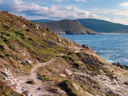
The Fishermen’s Trail is the 226.5 km coastal route of the Rota Vicentina in south-west Portugal, following the Atlantic edge of the Southwest Alentejo and Vicentine Coast Natural Park. It is a point-to-point hike from the Porto Covo area to Lagos, usually walked in 11–13 days, with 13 official one-day stages. The difficulty is moderate to demanding: there is no technical climbing, but long soft-sand sections, cliff undulations and Atlantic wind make it tougher than the low altitude suggests.
Route Overview
The usual walking start is Porto Covo in Alentejo, although the official trail begins about 10 km north at São Torpes beach. The route runs south via Vila Nova de Milfontes, Almograve, Cabo Sardão, Zambujeira do Mar, Odeceixe, Aljezur, Arrifana, Carrapateira, Vila do Bispo, Sagres, Cabo de São Vicente, Salema and Praia da Luz, finishing in Lagos in the western Algarve. This is a linear coastal trail, not a loop; transport details are not verified in the brief, so plan access and return travel separately. For a very different Portuguese long-distance route, compare the Caminho Português; for a shorter Atlantic-cliff walk, see the Ponta de São Lourenço Trail.
Fishermen’s paths on the Rota Vicentina
The route follows clifftop and beach paths used for generations by local fishermen — the “percursos dos pescadores” — to reach remote coves and rock-fishing spots along the Alentejo and Algarve coast. The Rota Vicentina association formalised and waymarked the network from around 2013, opening both the coastal Fishermen’s Trail and the inland Historical Way to long-distance walkers. The coastal route was later extended south beyond Sagres and Cabo de São Vicente to Lagos.
Notable highlights
- Cabo de São Vicente: The south-westernmost headland of mainland Europe, with a lighthouse on high limestone cliffs. It is a major landmark on the route, but not the finish of the current Fishermen’s Trail.
- Cabo Sardão near Cavaleiro: A clifftop lighthouse on the Alentejo coast, known for white storks nesting on sea stacks and cliff ledges above the Atlantic.
- Odeceixe beach: A wide crescent of sand where the Seixe river meets the ocean, on the Alentejo/Algarve border. It is a memorable coastal stop and a popular surf area.
- Vila Nova de Milfontes: A whitewashed town on the Mira river estuary with a small fortress. It is a natural early rest and resupply point on the trail.
- Praia do Amado and Carrapateira dunes: A renowned surf beach and dune-and-cliff area on the Costa Vicentina, showing the wilder Atlantic character of the southern half.
- Southwest Alentejo and Vicentine Coast Natural Park: The protected coastal landscape that gives the trail its cliffs, dunes, beaches, seabirds and endemic plants. If you want another protected-area walking option in Portugal, see the Peneda-Gerês National Park Trails.
Challenges to expect
Expect slow going on sand: around 60–70% of the route is soft sand, with long beach and dune sections. The trail also has repeated short climbs and descents over cliffs, full Atlantic wind exposure, and sections close to unfenced cliff edges, so it is not ideal for hikers with vertigo. Waymarking is generally excellent, using blue-and-green Rota Vicentina marks, not red-and-white GR markings. There are no huts; overnight stops are in villages.
HikeList Score
Fishermen’s Trail (Rota Vicentina) scored 84/100 on HikeList's trail-quality metrics.
See score breakdownHide breakdown
- Ideal length 91
- Balanced challenge 84
- Scenery & wildness 68
- Varied terrain 100
- Accommodation 83
- Food & support 81
- Path quality 98
- Season flexibility 89
Computed from length, challenge, scenery & wildness, terrain variety, accommodation, food & support, path quality and season flexibility.
 Portugal
Show more data Show less
- Coastal
- Clifftop
- Dunes
- Beaches
- Sand
- Single Track
- Beach
- Field Tracks
- Hotels
- Hostels
- Campsites
- Family Friendly
- Pet Friendly
- Restrooms
- Water Sources
- Campsites
Download Our Full Guide to Fishermen’s Trail (Rota Vicentina) FREE!
Get our comprehensive guide to this hike for free. Save it for later reading or print out at home.
In these collections
Photos from hikers
Taken on the trail by people who've reviewed Fishermen’s Trail (Rota Vicentina).
Fishermen’s Trail (Rota Vicentina): The Complete Guide
Recommended Itinerary
The most practical end-to-end plan from Porto Covo to Lagos is 12 walking days, using the main overnight villages on the route. This keeps the longer sandy sections manageable, avoids unnecessary transfers between stages, and finishes with two shorter Algarve stages into Praia da Luz and Lagos.
Distances are approximate and can vary slightly between GPS tracks and operator itineraries. Check official mapping before booking accommodation, especially if starting at Praia de São Torpes rather than Porto Covo.
Standard itinerary: 12 walking days
| Day | From | To | Approx. distance | Why this stage makes sense | Services/accommodation notes |
|---|---|---|---|---|---|
| 1 | Porto Covo | Vila Nova de Milfontes | 19 km | A demanding but logical opening stage from the usual walking start, with immediate exposure to the trail’s mix of sand, dunes and clifftop paths. | Both Porto Covo and Vila Nova de Milfontes have walker accommodation. Vila Nova de Milfontes is a natural early resupply point on the Rio Mira. |
| 2 | Vila Nova de Milfontes | Almograve | 16 km | A shorter day after the opening stage, useful because the Rio Mira crossing can affect timing. | The Mira river is normally crossed by a small seasonal ferry to the south bank; use the road-bridge detour when it is not running. This should be checked before travelling. Almograve has village accommodation. |
| 3 | Almograve | Zambujeira do Mar | 22 km | One of the longer northern stages, but it links two established overnight stops without needing a transfer. The route passes the Cavaleiro / Cabo Sardão area. | Book ahead in Zambujeira do Mar, especially in peak periods. Expect long exposed coastal walking with limited shade. |
| 4 | Zambujeira do Mar | Odeceixe | 19 km | A well-balanced stage to the Alentejo/Algarve border area, finishing near one of the route’s key beach-and-river landscapes at Praia de Odeceixe and the Rio Seixe. | Odeceixe is a standard overnight stop with guesthouses and other small-scale accommodation. |
| 5 | Odeceixe | Aljezur | 23 km | One of the longest days in the standard plan, so start early and allow for slow progress on sand. It keeps the itinerary moving between established towns. | Aljezur is one of the more useful overnight stops for accommodation and practical resupply. |
| 6 | Aljezur | Praia da Arrifana | 18 km | A moderate-length day after the longer Odeceixe–Aljezur stage, finishing at the surf beach settlement of Praia da Arrifana. | Accommodation is available around Praia da Arrifana, but choice can be tighter than in larger towns; book early. |
| 7 | Praia da Arrifana | Carrapateira | 21 km | A full coastal walking day linking two key Costa Vicentina surf areas, with more exposed cliff and dune terrain. | Carrapateira is a normal overnight stop. Do not rely on finding late-notice rooms in busy periods. |
| 8 | Carrapateira | Vila do Bispo | 19 km | A practical transition stage into the southern section, ending in Vila do Bispo before the approach to Sagres and Cabo de São Vicente. | Vila do Bispo has accommodation and is a useful base before the more exposed south-western headland stages. |
| 9 | Vila do Bispo | Sagres | 21 km | A longer southern stage, with the route reaching the higher cliff country around Vila do Bispo / Sagres. It positions walkers for the Cabo de São Vicente area without ending the trail there. | Sagres is a major overnight stop on the route. Remember that Cabo de São Vicente is a landmark on the route, not the finish. |
| 10 | Sagres | Salema | 20 km | A solid day continuing east from Sagres along the Algarve coast, keeping the final approach to Lagos in two shorter stages. | Salema has accommodation, but it is a small coastal village; advance booking is sensible. |
| 11 | Salema | Praia da Luz | 12 km | A deliberately shorter day after several 19–23 km stages, useful for tired legs and for managing the cumulative effect of sand and cliff climbs. | Praia da Luz is an established overnight stop close to the final stage into Lagos. |
| 12 | Praia da Luz | Lagos | 11 km | A short final stage into the harbour town of Lagos, leaving time for onward transport planning or an overnight stay at the finish. | Lagos has the widest range of finish-point services and onward transport links, including access towards Faro and Lisbon. |
Slower variant: 13+ days
A slower plan suits walkers carrying full packs, anyone uncertain about the soft-sand difficulty, and those who want more time around the larger stops such as Vila Nova de Milfontes, Odeceixe, Sagres or Lagos.
The cleanest slower option is to add the official northern start at Praia de São Torpes, about 10 km before Porto Covo, as an extra opening section. Another sensible option is to keep the 12 walking stages above and add a rest day at one of the better-served towns rather than trying to split stages where accommodation may be limited.
| Variant | How it changes the standard plan | Who it suits | Planning note |
|---|---|---|---|
| Add Praia de São Torpes to Porto Covo | Adds the official start section before Day 1 | Walkers who want the full official line rather than the common Porto Covo start | Transport to Praia de São Torpes and any start logistics should be checked before travelling. |
| Add a rest day | Keeps the 12 walking days but adds a non-walking day in a larger stop | Walkers carrying their own luggage, spring flower watchers, or anyone wanting margin for wind, heat or fatigue | Vila Nova de Milfontes, Odeceixe, Sagres or Lagos are the most practical places from the route list. |
Faster variant: 11 days
An 11-day itinerary is possible for strong walkers by combining the final two short stages, walking Salema to Lagos in one day via Praia da Luz. Using the stage distances, that makes a final day of about 23 km.
This faster version is best for fit hikers travelling light, ideally with luggage transfer, who are comfortable with repeated sandy walking and do not need long stops on the final Algarve section.
| Faster option | Combined stage | Approx. distance | Trade-off |
|---|---|---|---|
| 11 walking days | Salema to Lagos, combining Salema–Praia da Luz and Praia da Luz–Lagos | 23 km | Saves one night but turns the relaxed final approach into a long day. Book Lagos accommodation and onward transport with enough margin for a late finish. |
Avoid compressing the earlier itinerary unless already well-conditioned for sand. The 21–23 km stages are much harder than their distance suggests because so much of the route is on soft sand, with repeated short climbs and full Atlantic exposure.
Planning the Route
How many days to allow
Most walkers should plan this as an 11–13 day walk, with 12 walking days being the natural schedule from Porto Covo to Lagos using the main overnight villages. The official route is divided into 13 one-day stages, but many walkers begin at Porto Covo rather than the official start at Praia de São Torpes, about 10 km further north.
Do not plan the Fishermen’s Trail purely by map distance. The daily kilometre figures look modest, but the soft sand, repeated short climbs out of beaches and coves, Atlantic wind exposure and slow cliff-edge walking make the days more tiring than a low-altitude coastal route might suggest.
A faster 11-day itinerary is possible by combining one of the shorter southern days, such as the final Salema–Praia da Luz–Lagos section, but this is best kept for fit walkers travelling light. A 13-day plan gives more margin for the São Torpes start, a shorter day, or a rest/resupply pause in a larger village such as Vila Nova de Milfontes, Aljezur, Sagres or Lagos.
Let the villages dictate the stages
This route is naturally planned village-to-village. Accommodation and food are concentrated in the coastal settlements: Porto Covo, Vila Nova de Milfontes, Almograve, Zambujeira do Mar, Odeceixe, Aljezur, Praia da Arrifana, Carrapateira, Vila do Bispo, Sagres, Salema, Praia da Luz and Lagos.
There are no mountain huts, and wild intermediate stops are not the normal way to walk the trail. For most independent hikers, the practical plan is to book each night in advance, then walk the established stage between settlements.
The biggest accommodation pressure is in July and August, when beds in the smaller coastal villages can book out quickly. Guesthouses, small hotels, hostels and campsites are the usual options, and luggage-transfer services are widely offered by operators for walkers who want to carry only a daypack.
Choosing the start and finish
Porto Covo is the usual walking start and the simplest place to begin. The official route begins at Praia de São Torpes near Sines, so hikers wanting the full official line should add the extra northern approach and arrange transport accordingly; ask for the São Torpes stop if using the coach and starting there. This should be checked before travelling.
The route now finishes in Lagos, not at Cabo de São Vicente. Cabo de São Vicente remains a major landmark on the southern section near Sagres, but the coastal trail continues east through Salema and Praia da Luz to Lagos.
Because this is a point-to-point trail, access and return transport should be planned before booking accommodation. Lisbon is the usual access city for Porto Covo, with Rede Expressos coaches from Lisbon Sete Rios or Oriente taking roughly 2.5–3 hours. From Lagos, Faro is the nearest airport, with onward regional buses and the Algarve railway line, plus longer-distance connections to Lisbon. Current timetables and prices should be checked before travelling.
Where route planning can catch walkers out
The Rio Mira crossing after Vila Nova de Milfontes is an important planning point. The normal crossing to the south bank is by a small seasonal ferry; when it is not running, walkers need to use a road-bridge detour. Check the current ferry timetable before fixing that day’s accommodation and start time.
Beach sections and sandy dune paths are a defining feature of the trail. Some days can feel slow even when the distance is under 20 km, especially in heat or strong wind. Build in earlier starts and avoid assuming road-walking pace.
The cliffs are actively eroding and often unfenced. Stay well back from edges, follow the blue-and-green Rota Vicentina waymarks rather than informal cliff traces, and avoid this route if exposed cliff walking or heights are a serious issue.
Shortening, extending and section hiking
Section hiking is very practical because the route is broken by real villages with accommodation and transport links. The most straightforward sections are the northern Alentejo coast from Porto Covo to Odeceixe, the wilder Costa Vicentina stages from Odeceixe to Sagres, and the southern Algarve continuation from Sagres to Lagos.
Shortening the walk is easiest by finishing at one of the larger settlements rather than trying to leave from an isolated beach. Vila Nova de Milfontes, Odeceixe, Aljezur, Vila do Bispo, Sagres and Lagos are the most natural decision points for breaking the journey, changing plans or building a shorter itinerary.
Extending north to Praia de São Torpes gives the official start. Extending beyond Lagos is outside the Fishermen’s Trail route described here and would need separate planning.
What to book and check first
Prioritise the practical constraints in this order:
- Accommodation: book village stays early, especially for July–August and for the smaller overnight stops.
- Transport: arrange Lisbon-to-Porto Covo access and Lagos return travel before committing to fixed dates.
- Mira ferry: check the Vila Nova de Milfontes ferry timetable or plan the road-bridge alternative.
- Weather and season: spring is the most reliable planning choice for pleasant walking and wildflowers; autumn and winter can also work, but Atlantic wind and exposed conditions matter.
- Food and water: resupply in the overnight villages and do not rely on frequent services between them. Carry enough water for long exposed stretches with little shade.
- Navigation: use the Rota Vicentina blue-and-green waymarks, not red-and-white GR markings, and carry an offline map or GPX as backup.
- Trail updates: check the official Rota Vicentina information for diversions, cliff safety notices, beach-passability notes and current local conditions before setting off.
Permits are not the main planning constraint on this walk. Accommodation, transport, ferry timing, heat, wind and cliff safety matter far more in practice.
Towns, Villages and Overnight Stops
Accommodation on the Fishermen's Trail is based around coastal villages and small towns, not huts or remote camps. Expect guesthouses, small hotels, hostels and campsites in the main overnight stops, with locally owned lodging common and luggage-transfer services widely available between stages.
Book ahead in July and August, when beds in the smaller villages can fill quickly. Outside peak season, opening days for restaurants, cafés, shops and campsites can vary, so evening food and next-day supplies should be checked before travelling.
Praia de São Torpes
Praia de São Torpes, near Sines, is the official northern start of the Fishermen's Trail, around 10 km before Porto Covo. Most walkers do not overnight here, instead starting in Porto Covo for easier staging and better village facilities.
If beginning at São Torpes, ask for the São Torpes stop when using the Lisbon–Porto Covo coach service. Accommodation, food and water options at the actual beach start should not be assumed; this should be checked before travelling.
Porto Covo
Porto Covo is the usual practical trailhead and the first main overnight base for most walkers. It is a small Alentejo fishing village with guesthouses, small hotels, hostels and campsite-style options in or around the village.
This is the best place to arrive the day before walking, sort luggage transfer if using it, and buy any last-minute food before the first stage to Vila Nova de Milfontes. Rede Expressos coaches run from Lisbon Sete Rios / Oriente to Porto Covo in roughly 2.5–3 hours, with fares varying by booking and date.
Porto Covo also gives a straightforward start to the first coastal stage, with views towards Ilha do Pessegueiro. In high season, do not treat it as a place where a same-day bed will necessarily be available.
Ilha do Pessegueiro
Ilha do Pessegueiro is an offshore island passed early on the route rather than an overnight stop. It is useful mainly as a landmark between Porto Covo and Vila Nova de Milfontes.
There is no reason to plan accommodation around the island itself. Carry what is needed from Porto Covo and continue with the day’s stage as planned.
Vila Nova de Milfontes
Vila Nova de Milfontes is one of the most useful early trail towns and a natural overnight, rest and resupply point. It sits on the Rio Mira (Mira river) estuary and has a wider choice of lodging than the smaller villages before and after it.
Food, cafés and shops are generally more useful here than in the smaller stage stops, making it a sensible place to restock snacks and check plans for the next day. The route south normally uses a small seasonal ferry across the Rio Mira; when it is not running, walkers need to use the road-bridge detour.
The ferry timetable is an important planning detail and should be checked before travelling. If walking early or late in the season, do not assume the ferry will fit your preferred start time.
Almograve
Almograve is the standard overnight stop after Vila Nova de Milfontes on the usual stage plan. It is a smaller village, so accommodation should be booked rather than left to chance.
Expect village-scale services: enough for a normal overnight if planned properly, but not the same margin of choice as Vila Nova de Milfontes. Check restaurant and shop opening times outside the main walking season, especially if arriving late.
Almograve is also a useful place to reset after the first two sand-heavy days. Carry next-day food if relying on an early start or if accommodation does not provide breakfast.
Cavaleiro / Cabo Sardão
Cavaleiro and nearby Cabo Sardão sit between Almograve and Zambujeira do Mar, and are not a standard overnight stop on the main stage sequence. The area is best treated as a daytime landmark rather than a dependable place to finish a stage.
Cabo Sardão is important for hikers because the clifftop lighthouse area is one of the notable points on the Alentejo coast, with white storks nesting on sea stacks and cliff ledges. Keep well back from the cliff edges here, as along the rest of the route.
Accommodation and food around Cavaleiro should not be assumed without arranging it in advance. If planning to break the Almograve–Zambujeira do Mar stage here, this should be checked before travelling.
Zambujeira do Mar
Zambujeira do Mar is a regular overnight village on the northern half of the trail. It stands above small sandy coves and is a practical stop after the Almograve stage.
Accommodation is available in the village, but capacity is limited compared with larger towns, so booking ahead is sensible. Food and basic supplies are normally part of the village stop, though exact opening hours can change seasonally.
This is a good place to recover before the walk to Odeceixe, another exposed coastal stage with sand, cliffs and limited shade. Sort water and snacks before leaving rather than relying on intermediate services.
Odeceixe
Odeceixe is a key overnight stop at the transition towards the Algarve side of the route. The nearby Praia de Odeceixe, where the Rio Seixe (Seixe river) meets the Atlantic, is one of the most memorable beach locations on the trail.
The village has accommodation suitable for walkers, including guesthouse-style options. It is also a sensible place to eat properly and prepare for the longer stage towards Aljezur.
Treat Odeceixe as a booked stop rather than a flexible last-minute option in summer. Transport onward from smaller coastal and inland villages can be limited or seasonal, so any non-walking exit plan should be checked before travelling.
Aljezur
Aljezur is a useful overnight town after the Odeceixe stage and before the route turns towards Praia da Arrifana. It is one of the better places on the itinerary for practical errands because it is a town rather than a small beach village.
Accommodation is part of the normal trail infrastructure here, with guesthouses and other small-scale lodging used by walkers. Food and resupply options are generally more useful than in the smaller coastal settlements, but opening times still matter outside peak months.
This part of the route includes links that share the inland Historical Way rather than being continuous clifftop trail throughout. Check the current Rota Vicentina route information before setting off, particularly if following older GPX files or guidebooks.
Praia da Arrifana
Praia da Arrifana is the standard overnight stop after Aljezur on the practical stage plan. It is a coastal surf settlement below high cliffs, with accommodation available but less urban flexibility than Aljezur.
Book lodging ahead, especially if aiming to stay close to the beach rather than back in the wider Aljezur area. Food options can be seasonal, so check dinner and breakfast arrangements when booking accommodation.
The next stage to Carrapateira is another committing coastal day. Leave with enough water and food for the full walk rather than assuming frequent services en route.
Carrapateira
Carrapateira is a regular overnight stop between Praia da Arrifana and Vila do Bispo. It is associated with the dunes and coast around Bordeira and Praia do Amado, one of the wilder-feeling parts of the southern half.
Accommodation is available, but it remains a small village stop and should be booked. Food, cafés and shops should be treated as village-scale services with seasonal variation.
Carrapateira is a sensible place to pause before the route turns towards Vila do Bispo and the higher southern cliff sections. If walking with luggage transfer, confirm the exact accommodation address carefully because small settlements can have dispersed lodging.
Vila do Bispo
Vila do Bispo is an important overnight stop before the Sagres stage. It sits on the southern part of the route, where the trail reaches its higher cliff country around Vila do Bispo and Sagres.
Accommodation is available and the town is a useful practical base compared with smaller beach settlements. Food and supplies should be sorted here before the exposed walk towards Sagres.
This is also a good place to check weather and wind forecasts before the Cabo de São Vicente area. The walking is not technical, but exposure and cliff-edge awareness are serious planning factors.
Sagres
Sagres is a major overnight stop near the south-western corner of Portugal. It is the base for the route section around Cabo de São Vicente, but it is not the end of the Fishermen's Trail, which continues east to Lagos.
Accommodation, food and walker services are available, with more choice than in the smallest villages. Even so, summer bookings should be made ahead because Sagres is a popular coastal destination as well as a trail stop.
Use Sagres to plan the next two days carefully: the route continues to Salema and then Praia da Luz before the final approach to Lagos. Local transport or shortcuts around the headland should be checked before travelling if needed.
Cabo de São Vicente
Cabo de São Vicente (Cape St Vincent) is a major headland landmark reached on the route near Sagres. It is a powerful psychological waypoint, but it is not the trail finish.
Do not plan this as a normal overnight stop. Treat it as an exposed headland visit on the walking day, with services and transport checked in advance if relying on anything other than walking back or onwards.
The cliffs here demand the same caution as the rest of the trail, with extra care in wind. Stay well back from unfenced edges and avoid stepping onto eroded cliff margins for photographs.
Salema
Salema is the overnight stop after Sagres on the standard stage sequence. It breaks the final western Algarve section into manageable coastal days before Praia da Luz and Lagos.
Accommodation is available in the village, but the usual summer warning applies: book ahead and confirm arrival arrangements. Food and cafés should be checked seasonally, particularly for early breakfasts.
This is a practical stop rather than a major resupply centre. Carry enough for the following day to Praia da Luz, especially if leaving before shops or cafés open.
Praia da Luz
Praia da Luz is the penultimate overnight stop on the usual route, leaving a short final walk to Lagos. It is a good option for walkers who do not want to combine the last two stages or rush into the finish.
Accommodation and food are available, with guesthouses, small hotels and other coastal lodging used by walkers. In busy periods, book ahead rather than assuming a same-day room.
The final stage to Lagos is comparatively short, so Praia da Luz works well for a slower last morning or for timing onward travel from Lagos later in the day. Confirm any luggage transfer or onward transport timing before committing to a same-day departure.
Lagos
Lagos is the finish of the extended Fishermen's Trail and the main transport hub at the southern end. It is a harbour town with a much wider range of accommodation, food and onward travel options than the smaller villages along the coast.
The nearest airport is Faro, about 90 km east, reached from Lagos by regional buses and the Algarve railway line. Onward trains and coaches also run to Lisbon, making Lagos the most practical place to end, wash kit, and connect to wider travel.
Book a final night if arriving late, walking in high season, or relying on luggage transfer. This gives a safer buffer for delays caused by heat, wind, route diversions or slower-than-expected sand walking on the final stages.
Getting to the Start
By train
Porto Covo does not have a direct rail connection, so train is not the simplest way to reach the usual start of the Fishermen’s Trail. Most walkers use Lisbon as the access point and continue by coach to Porto Covo.
If planning a rail-and-taxi approach via a nearby town, check current Portuguese rail and local taxi options before committing to it. This should be checked before travelling.
By bus
The most straightforward public transport option is the Rede Expressos coach from Lisbon to Porto Covo. Services run from Lisbon Sete Rios and Lisbon Oriente, with a journey time of roughly 2.5–3 hours and typical fares around EUR 7–17.
Porto Covo is the usual walking start used by most hikers and operators. The official trail begins about 10 km north at Praia de São Torpes near Sines; if starting there rather than in Porto Covo, ask for the São Torpes stop when booking or boarding. Current timetables, stop arrangements and fares should be checked before travelling.
By car
Driving to Porto Covo is possible, but the Fishermen’s Trail is a point-to-point route ending in Lagos, not a loop. Leaving a vehicle at the start creates a return-transport problem at the end of the hike.
There is no reliable long-stay parking detail to plan around here. If arriving by car, ask your Porto Covo accommodation about current parking options and whether leaving a vehicle for the full walk is realistic. This should be checked before travelling.
A taxi can be useful for awkward arrival times, for a short transfer between Porto Covo and Praia de São Torpes, or if public transport is limited on the day you arrive. Agree the fare before setting off.
From the nearest airport
For the start, Lisbon is the usual airport gateway. From Lisbon, transfer to Sete Rios or Oriente for the Rede Expressos coach to Porto Covo.
Faro is more relevant for leaving the trail from Lagos at the finish, rather than for reaching the Porto Covo start. If flying into Faro and starting in Porto Covo, allow for a longer cross-country transfer and check current train, coach and connection times before booking flights.
Where to stay before starting
Porto Covo is the best place to stay before beginning the walk. It has the practical advantage of being the standard trailhead for most itineraries, with accommodation in the village and an easy first stage onwards to Vila Nova de Milfontes.
Accommodation along the route is mainly guesthouses, small hotels, hostels and campsites. Beds in Porto Covo and the coastal villages can book out quickly in July and August, so reserve early if travelling in peak season.
If choosing the official Praia de São Torpes start, it is still usually simplest to base the night before in Porto Covo or to arrange transport to the start point. Confirm the latest bus stop details or taxi availability before relying on this plan.
Getting Home from the Finish
The Fishermen's Trail now finishes in Lagos, which is a practical end point for onward travel. Unlike many of the smaller coastal villages earlier on the route, Lagos has rail and bus connections, accommodation, taxis and onward links towards Faro and Lisbon.
Timetables are still the key planning point. Check current train, coach and regional bus times before committing to a same-day flight or long onward journey, especially if finishing late in the afternoon.
By train
Lagos is on the Algarve railway line, making the train a useful option for reaching Faro and other onward connections. Faro is the main transport hub to the east and the nearest airport city for the trail finish.
For Lisbon, plan around the available onward train connections from the Algarve. Exact routes, connection points and journey times vary by timetable, so this should be checked before travelling.
If the final walking day from Praia da Luz to Lagos finishes late, staying overnight in Lagos is usually the safer plan than relying on the last transport connection of the day.
By bus
Regional buses run from Lagos towards Faro, and onward coach services also connect the Algarve with Lisbon. This gives a useful alternative to the train, particularly if the day’s rail times do not fit your finish time.
Bus frequency can vary by season, day of the week and public holidays. Check current timetables before travelling, and avoid booking a tight same-day flight connection unless there is a clear margin after the expected finish time in Lagos.
By car/taxi
Taxis and private transfers are practical for short local movements around Lagos, for reaching accommodation, or for a direct transfer towards Faro if public transport times are awkward. Faro is about 90 km east of Lagos, so confirm the fare before booking a taxi or private transfer.
Because this is a point-to-point hike, leaving a car at the start in Porto Covo is usually inconvenient unless there is a separate plan to retrieve it. If using a car, it is often more practical to position it at the finish in Lagos or use public transport at one end of the trip.
From the nearest airport
Faro Airport is the nearest airport for the Lagos finish, about 90 km to the east. From Lagos, use the Algarve railway line or regional buses towards Faro, then allow for the additional airport connection.
For international flights, build in a buffer after the final stage. The last day from Praia da Luz to Lagos is relatively short, but delays can still happen through heat, tired legs, accommodation check-out logistics or simply taking longer than expected on the approach to Lagos.
Lisbon is also an onward option by train or coach from the Algarve, but it is farther away and should be treated as a longer transfer rather than a quick end-of-walk connection.
Where to stay at the finish
Lagos has guesthouses, small hotels, hostels and campsites, so it is a sensible place to spend the final night before travelling on. Staying overnight removes pressure from the last walking day and gives more choice of morning trains, buses or airport transfers.
Accommodation in the Algarve can book out quickly in July and August. Reserve ahead if finishing in peak season, and confirm check-in arrangements if arriving late from Praia da Luz.
Which Direction Should You Walk?
Standard direction: Porto Covo to Lagos
The standard and most common direction is north to south, starting at Porto Covo — or at the official start near Praia de São Torpes — and finishing in Lagos. This is the direction that best matches the usual stage flow, accommodation planning and the way most walking operators package the route.
It also works well for transport. From Lisbon, Rede Expressos coaches run to Porto Covo in roughly 2.5–3 hours, making the northern trailhead straightforward to reach. Finishing in Lagos leaves you in a larger Algarve town with onward regional buses, the Algarve railway line, connections towards Faro airport and onward services to Lisbon.
Scenically, north to south gives the route a strong sense of progression. The walk begins on the wilder Alentejo coast, passes Vila Nova de Milfontes, Cabo Sardão, Zambujeira do Mar and Odeceixe, then moves into the more rugged western Algarve stages via Aljezur, Praia da Arrifana, Carrapateira, Vila do Bispo and Sagres. Cabo de São Vicente becomes a major late-route landmark before the final easier-feeling approach through Salema and Praia da Luz to Lagos.
The psychological finish is better southbound. Lagos is a practical and satisfying end point: it has more services than many of the smaller coastal villages, better onward transport, and enough accommodation and food options to absorb tired walkers at the end of a long point-to-point route.
Reverse direction: Lagos to Porto Covo
Walking south to north is entirely possible for an independent hiker, but it is less conventional. It can make sense if flight plans are built around Faro airport and you want to start in the Algarve, or if accommodation availability forces a reverse itinerary in peak periods.
The main drawback is that the route’s big southern landmarks come early. Sagres, Cabo de São Vicente and the high southern cliff stages are encountered near the beginning rather than as a build-up, and the walk ends in Porto Covo rather than in the larger transport hub of Lagos. Porto Covo is a pleasant trailhead village, but it is less convenient as a finale if immediate onward travel is needed.
Reverse walkers should also be more careful with logistics. Luggage-transfer providers and self-guided itineraries are widely available on the Fishermen’s Trail, but many standard schedules are designed north to south. Reverse luggage movement, stage timing and accommodation check-ins should be arranged explicitly before booking.
Does either direction make the walking easier?
There is no major climbing advantage either way. The trail stays low overall, with repeated short cliff climbs and descents rather than long mountain ascents, and the toughest physical factor is the soft sand rather than the gradient.
Wind matters more than ascent on exposed days, but it should not be treated as a fixed reason to choose a direction. The Fishermen’s Trail is open to Atlantic weather for long stretches, so current forecasts should be checked before travelling and daily plans adjusted if conditions are poor, especially near unfenced and eroding cliff edges.
The seasonal Mira river crossing at Vila Nova de Milfontes does not strongly favour either direction. If the small ferry is not running, walkers use the road-bridge detour, so the current ferry timetable should be checked before travelling.
Recommendation
For most hikers, walk the Fishermen’s Trail north to south: Porto Covo to Lagos, or São Torpes to Lagos if completing the official start. It fits the standard stage sequence, makes transport straightforward, gives the best scenic build-up, and finishes in the most practical town for onward travel.
Walk it in reverse only if flights, accommodation availability or a specific itinerary make Lagos a better starting point. In that case, book accommodation and any luggage transfer carefully, and check current transport and ferry details before committing to dates.
Reviews
How would you rate Fishermen’s Trail (Rota Vicentina)?
Tap a star to start your review — you could be the first.