Beacons Way
Beacons Way: A Complete Hiking Guide
HikeList Score
Beacons Way scored 85/100 on HikeList's trail-quality metrics.
See score breakdownHide breakdown
- Ideal length 98
- Balanced challenge 56
- Scenery & wildness 74
- Varied terrain 100
- Accommodation 100
- Food & support 88
- Path quality 92
- Season flexibility 89
Computed from length, challenge, scenery & wildness, terrain variety, accommodation, food & support, path quality and season flexibility.
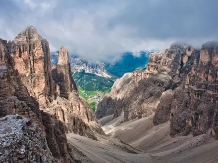
The Beacons Way is a 158 km point-to-point mountain trail across Bannau Brycheiniog / Brecon Beacons National Park in South Wales. Traditionally walked in 8 days from Abergavenny railway station to Llangadog, it is a strenuous route for experienced walkers, with 6,719 m of total ascent and long upland days. Expect remote moorland, open ridges, boggy ground after rain, and sparse waymarking on the tops. Good navigation skills are essential, especially in poor visibility.
Route Overview
The route runs broadly east to west from Abergavenny railway station in Monmouthshire to Llangadog in Carmarthenshire. It crosses the Black Mountains, the central Brecon Beacons and the Black Mountain (Y Mynydd Du), linking places such as Llanthony Priory, Crickhowell, Llangynidr, Storey Arms, Craig-y-Nos, Llanddeusant and Carreg Cennen Castle. It is linear and waymarked with a beacon/flame symbol, but signs are limited on open high ground. The National Park’s current Day 8 ends at Bethlehem, near Llangadog, after a 2016 realignment. For a gentler Welsh walk, compare the Aber Falls Walk; for a coastal alternative, see the Anglesey Coastal Path.
History of the Beacons Way
The Beacons Way was proposed in 2001 and opened in 2005 as the flagship long-distance trail of Bannau Brycheiniog / Brecon Beacons National Park. It was planned by John Sansom, a founder of the Brecon Beacons Park Society, with input from local walkers Arwel Michael and Chris Barber. The route was created to improve public access across the park and is sometimes described as running “from the Holy Mountain to Bethlehem”. It has been realigned, most recently in spring 2016.
Notable highlights
- Ysgyryd Fawr / Skirrid Fawr: The “Holy Mountain” above Abergavenny is an isolated, landslip-scarred ridge with the remains of a medieval St Michael’s chapel. It gives the trail its eastern start and its “Holy Mountain” epithet.
- Llanthony Priory: Atmospheric ruins of a 12th-century Augustinian priory in the Vale of Ewyas. It is reached at the end of Day 1 and is one of the strongest historical landmarks on the route.
- Crug Hywel / Table Mountain: A flat-topped hill above Crickhowell capped by an Iron Age hillfort. Its Welsh name, Hywel’s cairn, gives Crickhowell its name.
- Pen y Fan and Corn Du: The twin red-sandstone summits at the heart of the central Beacons. Pen y Fan, at 886 m, is the highest point on the route and the highest peak in southern Britain.
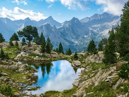
- Llyn y Fan Fach: A glacial lake below the Black Mountain escarpment. It is associated with the “Lady of the Lake” legend and is passed in the western stages.
- Carreg Cennen Castle: A medieval castle on a limestone crag. It was remodelled under John Giffard after Edward I’s conquest and was attacked unsuccessfully by Owain Glyndwr’s forces in 1403.
Challenges to expect
This is a strenuous mountain route, not a low-level waymarked trail. Day lengths range from 16 to 23.5 km, often with significant climbs. Expect remote moorland, rocky tracks, muddy or boggy ground after rain, and exposed ridges. Waymarking is sporadic on the open tops, so carry a map and compass or GPS and know how to use them. Accommodation is off-route or in nearby towns and villages.
HikeList Score
Beacons Way scored 85/100 on HikeList's trail-quality metrics.
See score breakdownHide breakdown
- Ideal length 98
- Balanced challenge 56
- Scenery & wildness 74
- Varied terrain 100
- Accommodation 100
- Food & support 88
- Path quality 92
- Season flexibility 89
Computed from length, challenge, scenery & wildness, terrain variety, accommodation, food & support, path quality and season flexibility.
Show more data Show less
- Mountainous
- Moorland
- Open Hill
- Glacial Lakes
- Limestone
- Upland Grass
- Moorland Paths
- Rocky Tracks
- Woodland Trails
- Quiet Lanes
- Canal Side Paths
- Hotels
- Inns
- Hostels
- Bunkhouses
- Campsites
- Wild Camping Spots
- Family Friendly
- Dog Friendly On Leash
- Restrooms
- Non Potable Water Sources
- Established Campsites
- Shelters
- Picnic Areas
In these collections
Hard stage from Abergavenny towards the Vale of Ewyas, finishing at the ruins of Llanthony Priory.
Hard stage linking Llanthony with Crickhowell, continuing through the eastern uplands of the park.
Moderate stage from Crickhowell to Llangynidr, with the route moving west through mixed upland and lower-level terrain.
Strenuous stage to Storey Arms. This is the hardest-graded day in the official itinerary and demands confident navigation in poor conditions.
Moderate stage from Storey Arms to Craig-y-Nos, continuing west from the central Beacons.
Hard stage from Craig-y-Nos to Llanddeusant, entering the western part of the route towards the Black Mountain.
Hard stage from Llanddeusant to Carreg Cennen Castle, a major landmark near the western end of the trail.
Easy final official stage to Bethlehem, near Llangadog. The traditional full trail terminus is Llangadog.