Albsteig (Swabian Jura Trail)
How would you rate Albsteig (Swabian Jura Trail)?
Tap a star to share your experience and help other hikers.
Albsteig (Swabian Jura Trail): HW1 Along the Albtrauf
HikeList Score
Albsteig (Swabian Jura Trail) scored 89/100 on HikeList's trail-quality metrics.
See score breakdownHide breakdown
- Ideal length 83
- Balanced challenge 84
- Scenery & wildness 98
- Varied terrain 83
- Accommodation 91
- Food & support 88
- Path quality 98
- Season flexibility 89
Computed from length, challenge, scenery & wildness, terrain variety, accommodation, food & support, path quality and season flexibility.
Albsteig (Swabian Jura Trail) is a hard, ~360 km point-to-point hike across southern Germany, usually walked in 16 stages from Donauwörth to Tuttlingen. Also known as HW1 or the Schwäbische-Alb-Nordrandweg, it follows the northern rim of the Swabian Jura/Schwäbische Alb, using the Albtrauf escarpment for a sustained sequence of climbs, descents and viewpoints. It suits fit hikers who want a well-waymarked, hotel-and-guesthouse-based long-distance trail rather than technical alpine terrain.
Route Overview
Start at Donauwörth, where the Wörnitz meets the Danube, and follow the red triangle waymark towards Tuttlingen on the upper Danube; the triangle tip points in the canonical direction. The official split is 16 point-to-point stages via Harburg, Mönchsdeggingen, Bopfingen below the Ipf, Aalen-Unterkochen, Heubach, Kuchalb, Boßler, Burg Teck, Bad Urach, Honau below Schloss Lichtenstein, Willmandingen, Jungingen, Burgfelden, Ratshausen and Risiberg. Accommodation is in towns, inns, guesthouses and Albverein Wanderheime, with no true wilderness-hut section. For other German multi-day options, compare Altmühltal Panorama Trail, Goldsteig or Eifelsteig.
History of the Albsteig HW1
The Albsteig is Hauptwanderweg 1 of the Schwäbischer Albverein, one of Germany’s oldest hiking clubs, founded on 13 August 1888 in Plochingen. The route is the association’s flagship long-distance trail and is also known as the Schwäbische-Alb-Nordrandweg. It was upgraded and certified as a Qualitätsweg Wanderbares Deutschland and became a Top Trail of Germany in 2012.
Notable highlights
- Harburg Castle (Schloss Harburg): A large, well-preserved Staufer-era castle above the Wörnitz, encountered near the beginning of the trail.
- Burg Teck: A hilltop castle and viewpoint on the Albtrauf, around the route’s mid-point and a classic Swabian landmark.
- Burgruine Hohenneuffen: A major ruined fortress on a limestone spur near Bad Urach, notable for its exposed escarpment position.
- Schloss Lichtenstein: The “fairy-tale castle of Württemberg”, built in 1840–42 on a crag above the Echaz valley at Honau, directly on the route.
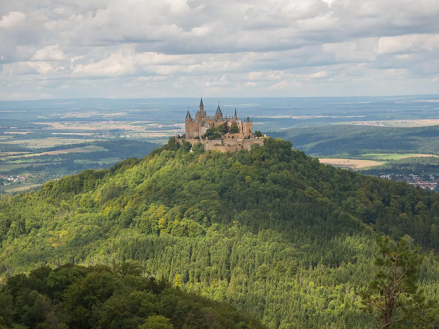
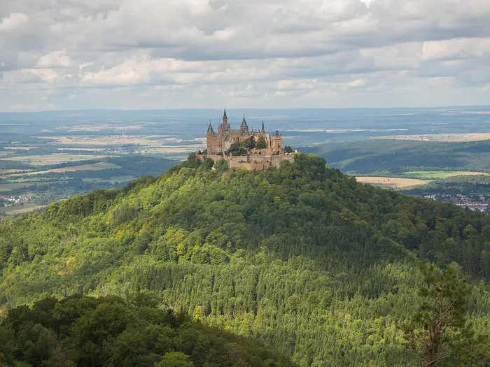
- Zeller Horn viewpoint: The classic viewpoint for the panorama of Burg Hohenzollern across the valley; the castle is seen from here, not visited as a stage stop.
- Lemberg (1,015 m): The highest summit of the Swabian Jura, near the western end of the trail, with wide views.
Challenges to expect
The Albsteig is hard because of repetition, not technical climbing: expect roughly 8,500 m of total ascent, frequent steep climbs and descents, and a roller-coaster profile along the Albtrauf. Paths are mostly natural, with dirt, rocky sections and gravel forest tracks. Exposed escarpment edges are weather-dependent, and some Albverein Wanderheime open only at weekends or holidays.
HikeList Score
Albsteig (Swabian Jura Trail) scored 89/100 on HikeList's trail-quality metrics.
See score breakdownHide breakdown
- Ideal length 83
- Balanced challenge 84
- Scenery & wildness 98
- Varied terrain 83
- Accommodation 91
- Food & support 88
- Path quality 98
- Season flexibility 89
Computed from length, challenge, scenery & wildness, terrain variety, accommodation, food & support, path quality and season flexibility.
 Germany
Show more data Show less
- Mountainous
- Forest
- Plateau
- Dirt
- Rocky
- Gravel
- Hotels
- Guesthouses
- Hostels
- Family Friendly
- Pet Friendly
- Restrooms
- Water Sources
- Campsites
- Shelters
- Picnic Areas
Download Our Full Guide to Albsteig (Swabian Jura Trail) FREE!
Get our comprehensive guide to this hike for free. Save it for later reading or print out at home.
Photos from hikers
Taken on the trail by people who've reviewed Albsteig (Swabian Jura Trail).
Albsteig (Swabian Jura Trail): The Complete Guide
 i
Image by maxmann
i
Image by maxmann The Albsteig is a long, demanding traverse of the Schwäbische Alb’s northern rim, following the Albtrauf from Donauwörth to Tuttlingen. It is the waymarked HW1 of the Schwäbischer Albverein, a red-triangle route built around escarpment walking, viewpoints, beech woods and limestone edges.
This is not an alpine trek, but it is a serious long-distance walk. Over about 358–360 km, the trail repeatedly drops into valleys and climbs back to the plateau, building roughly 8,000–9,000 m of ascent across the full route.
The reward is a route with strong daily structure: castles and ruined fortresses, juniper heath, wooded ridges, spa towns and high viewpoints over the Zollernalb. Schloss Harburg, Burg Teck, Schloss Lichtenstein, Zeller Horn and the Lemberg all give the walk clear landmarks from east to west.
Most walkers will suit it best as a hotel, Gasthof and Pension-based hike, with occasional Schwäbischer Albverein Wanderheime where opening days fit the plan. Fit first-time long-distance walkers can manage it with careful staging, but the full route favours hikers already comfortable with repeated climbs, long days and variable escarpment weather.
This guide covers stages, days, accommodation, food, transport, terrain and the common planning mistakes to avoid.
Stage-by-Stage Guide
The stage notes below follow the 16-stage Albsteig itinerary used on this page. The Schwäbischer Albverein also divides HW1 into a longer list of shorter stages, so accommodation and transport planning can be adjusted if the 16-stage days are too long. Distances are approximate and should be checked against your map or GPX before booking fixed overnight stops.
The red-triangle waymark points towards Tuttlingen. It is generally a reliable guide, but the Albsteig is a long escarpment route with many village approaches, forest junctions and viewpoint spurs, so a map or offline GPX is still sensible.
Stage 1: Donauwörth to Harburg — approx. 18 km
The route begins at the Rathaus in Donauwörth, where the Wörnitz meets the Danube, and leaves town following the red triangle westwards. This first day is a manageable introduction before the harder Albtrauf stages later on, with the line moving out of the Danube/Wörnitz setting towards the eastern Swabian Alb.
The main landmark is Schloss Harburg, a large Staufer-era castle above the Wörnitz and one of the strongest starts to the whole trail. Paths are a mix of town approaches, tracks and natural walking, with less of the relentless escarpment roller-coaster that defines the central and western sections.
Donauwörth is the best place to start fully supplied, and Harburg is a sensible overnight halt with accommodation in or near the town. Do not rely on finding frequent food or water between the two; carry enough for the day and check opening times before setting off.
Donauwörth has excellent rail access, including ICE and regional services. Harburg has road access and is a practical place to break the route, but current public transport options should be checked before travelling. Navigation is usually straightforward leaving Donauwörth, though extra attention is useful through built-up areas where waymarks can be easier to miss.
Stage 2: Harburg to Mönchsdeggingen — approx. 12 km
This is the shortest stage in the 16-day schedule and can feel like a half-day compared with the 25–27 km days that follow. It is useful as a gentle second day, particularly if arriving late in Donauwörth or taking time at Schloss Harburg before leaving.
The walking continues through the eastern approach to the Alb, using a mixture of field, woodland and village-linked paths. It is not one of the most dramatic viewpoint days, but it helps position the route for the longer push towards Bopfingen.
Food and water planning is simple but still important: start from Harburg with what is needed for the day, as intermediate services should not be assumed. Mönchsdeggingen is a smaller overnight stop, so accommodation and evening meals should be booked ahead rather than left to arrival.
Public transport at this point is more limited than at the larger rail towns on the route. If using this as a section-hike endpoint, connections should be checked before travelling. Navigation is mostly routine, but village exits and field-edge junctions are the places to watch for the red triangle.
Stage 3: Mönchsdeggingen to Bopfingen — approx. 27 km
The third stage is a sharp step up in distance and should be treated as a full walking day. The route passes through the eastern Alb country via Schweindorf before reaching Bopfingen, below the Ipf.
The Ipf is the key landmark: an isolated, flat-topped Zeugenberg and major early-Celtic site that dominates this part of the route. The walking is less technically difficult than it is sustained, with natural paths, tracks and open ground that can feel exposed in poor weather.
Carry enough food and water from Mönchsdeggingen, as this is a long stage and services in smaller villages should not be relied on without checking. Bopfingen is the main practical endpoint, with better prospects for accommodation and resupply than the smaller places earlier in the day.
Bopfingen has road and local transport access, but exact public transport times should be checked before travelling. The main navigation issue is keeping momentum over a long day: do not be tempted onto unplanned viewpoint or summit spurs unless time, daylight and weather allow.
Stage 4: Bopfingen to Aalen-Unterkochen — approx. 27 km
This is another long day and one of the first clear reminders that the Albsteig is an endurance trail rather than a simple ridge stroll. From Bopfingen, the route continues west across the eastern Swabian Alb, with Hülen appearing on the line before the finish at Aalen-Unterkochen.
The terrain becomes more typical of the full route: woodland, gravel forest tracks, natural paths and repeated changes in height. There is no technical alpine ground, but the cumulative effort builds quickly over consecutive 27 km days.
Bopfingen is the sensible place to stock up. Hülen may be a useful point on the route, but food, water and opening times should be checked before relying on it. Aalen-Unterkochen is a practical overnight stop, with access to the wider Aalen area.
Aalen is one of the better mid-route transport hubs, useful for joining, leaving or adjusting the itinerary. If fatigue is building after Stages 3 and 4, this is a logical place to reassess the schedule. Navigation is generally by the red triangle, but forest junctions can be frequent, so an offline map helps avoid small but time-consuming errors.
Stage 5: Aalen-Unterkochen to Heubach — approx. 24 km
This stage brings the route onto some of the stronger eastern Alb viewpoints, with Volkmarsberg and Rosenstein on or near the line above Heubach. It is a varied day of wooded heights, escarpment scenery and the first of several classic Albtrauf outlooks.
Underfoot, expect forest tracks, earth paths and rocky sections near the escarpment edge. The walking is not technical, but the climbs and descents can be steep, and care is needed in wet weather on natural ground and around viewpoints.
Start from Aalen-Unterkochen with a full day’s food and water unless current services have been checked. Heubach is the planned overnight stop and a sensible base for accommodation in the eastern third of the trail.
The Aalen area gives good transport flexibility at the start of the day; onward options from Heubach should be checked before travelling. Navigation around viewpoint areas such as Volkmarsberg and Rosenstein deserves attention, as local paths and short detours can intersect with the main HW1 line.
Stage 6: Heubach to Kuchalb (Donzdorf) — approx. 27 km
Heubach to Kuchalb is another demanding long stage, continuing the traverse of the Albtrauf westwards. Weißenstein lies on the route sequence, and the day links wooded escarpment sections with open high ground and settlement approaches.
This is classic Albsteig terrain: beech woodland, gravel tracks, natural paths and repeated ascents and descents rather than one single big climb. In damp conditions the forest sections can be muddy, while exposed edges and viewpoints are best treated with caution in wind, rain or low visibility.
Carry provisions from Heubach and do not assume regular refreshment stops. Kuchalb is associated with Donzdorf, but it is not a large service town on the ridge, so accommodation, evening meals and any transfers should be arranged in advance.
Road access exists in the wider Donzdorf/Kuchalb area, but public transport details should be checked before travelling. The navigation challenge is the length of the day and the number of forest and track junctions; keep checking that the red triangle is still leading towards Tuttlingen.
Stage 7: Kuchalb (Donzdorf) to Boßler — approx. 25 km
This stage crosses a practical but more thinly serviced section of the Albtrauf, passing through or near Gingen an der Fils, Gruibingen and the Kornbergsattel before reaching Boßler. It is a linking day with plenty of ridge-and-valley character rather than a simple point-to-point road walk.
The route alternates between forest, open ground and escarpment paths. Expect the usual Albsteig pattern of climbs to the edge and descents towards valleys, with the cumulative ascent becoming more important than any individual obstacle.
Gingen an der Fils, Gruibingen and Kornbergsattel are important planning names for the day, but services should be checked before relying on them. Boßler is not a large town finish, so accommodation at or near the endpoint must be planned carefully; this is a stage where booking ahead matters.
Public transport and road access may be possible via valley settlements, but exact connections should be checked before travelling. Navigation needs care around saddles and settlement approaches, where several local routes can converge.
Stage 8: Boßler to Burg Teck — approx. 24 km
This is one of the classic central Albtrauf days, finishing at Burg Teck, a prominent hilltop castle and viewpoint around the trail’s mid-section. The route passes through the Ochsenwang area and reaches the Teck/Owen section of the escarpment.
The terrain is varied and satisfying: woodland, open plateau edges, natural paths and viewpoint approaches. The final approach to Burg Teck gives the day a strong objective, but the walking remains a full 24 km stage with repeated height changes.
Carry food and water from the start unless services have been checked in advance. Overnight arrangements need particular care: Burg Teck is a landmark on the hill, while Owen lies below the castle, so accommodation may be at the castle area, in Owen, or in nearby settlements depending on availability. This should be checked before travelling.
Owen and the surrounding valley settlements can be useful for access, but current bus and rail connections should be checked. The main navigation issue is separating the main HW1 line from local paths around the popular Teck area; expect more walkers and more path options than on quieter stages.
Stage 9: Burg Teck to Bad Urach — approx. 23 km
From Burg Teck, the Albsteig continues west along the escarpment towards Bad Urach, one of the most useful towns on the whole route. Burgruine Hohenneuffen is nearby on a short detour rather than on the main line, so allow extra time if including it.
The stage keeps the familiar pattern of wooded edge paths, limestone viewpoints and descents into valleys. Paths can be rocky in places near the escarpment and slippery after rain, especially where leaf litter and mud build up in woodland.
Bad Urach is a strong resupply and accommodation stop, and it is a good place to plan a rest, laundry or schedule adjustment if needed. The Uracher Wasserfall is a popular nearby detour, but it is not on the main Albsteig line; do not add it late in the day unless time and daylight are secure.
Bad Urach has rail access, making this one of the best points for section hiking, joining, leaving or shortening the itinerary. Navigation into the town requires attention, as valley approaches and local walking routes can create several options away from the ridge.
Stage 10: Bad Urach to Honau — approx. 26 km
This is a long, high-value stage linking Bad Urach with Honau beneath Schloss Lichtenstein. It is one of the route’s most memorable days because Schloss Lichtenstein sits directly on the Albsteig above the Echaz source area.
The walking is typical western Albtrauf: forested slopes, plateau-edge paths, natural ground and viewpoints. There is no scrambling, but the length of the stage and the repeated climbs make it a serious day after leaving the comfort of Bad Urach.
Bad Urach is the best place to leave fully supplied. Services along the way should be checked before relying on them, and Honau accommodation should be booked ahead, especially if using a fixed 16-stage schedule.
Bad Urach is the strongest public transport point for the start; onward access from Honau should be checked before travelling. Around Schloss Lichtenstein, expect more local visitors and path options, so follow the red triangle carefully and do not confuse castle access paths with the onward HW1 route.
Stage 11: Honau to Willmandingen — approx. 22 km
Leaving Honau, the route moves on from the Schloss Lichtenstein area into a quieter plateau and village stage. Holzelfingen lies on the route sequence before the finish at Willmandingen.
The day is moderate by Albsteig standards, but still includes the usual mix of woodland, open ground and rolling escarpment terrain. Footing is mostly natural paths and tracks, with weather-dependent mud possible in forested sections.
Honau should be treated as the morning supply point only if current services are available; otherwise carry what is needed from the previous larger stop. Holzelfingen and Willmandingen are smaller places, so food, evening meals and accommodation must be checked and booked before arrival.
Public transport on this stage is less straightforward than at Bad Urach or Aalen. If using Honau, Holzelfingen or Willmandingen as section endpoints, current bus connections should be checked before travelling. Navigation is usually uncomplicated on the open sections, but village exits are the places most likely to cause small mistakes.
Stage 12: Willmandingen to Jungingen — approx. 24 km
This stage continues west through the central-western Alb, passing the Willmandingen/Genkingen area and Talheim before reaching Jungingen. It is a solid walking day that positions the route for the Zollernalb viewpoints that follow.
The terrain remains a mixture of open plateau, farmland, woodland and escarpment-edge walking. The day is not technically difficult, but it should not be underestimated: 24 km on rolling Albtrauf terrain can be tiring, especially after nearly two weeks on trail.
Carry lunch and water unless services in Genkingen or Talheim have been checked. Jungingen is the planned overnight halt; accommodation and dinner arrangements should be booked ahead, particularly outside the busiest walking periods.
Road and bus access may be available through the villages, but timings should be checked before travelling. Navigation is mostly about consistency: keep following the red triangle and avoid being drawn onto local circular walks around the villages.
Stage 13: Jungingen to Burgfelden — approx. 22 km
This is one of the signature Zollernalb stages, with Onstmettingen, Zeller Horn and Raichberg in the route sequence. The classic view from Zeller Horn looks across the valley to Burg Hohenzollern; the castle is admired from the viewpoint and is not a stop on the Albsteig.
Expect escarpment-edge walking, wooded sections and exposed viewpoints. Dreifürstenstein and Hangender Stein belong to this western half of the route and are part of the wider sequence of dramatic Albtrauf outlooks around the Zollernalb.
Food and water should be carried from Jungingen unless current services have been checked in Onstmettingen. Burgfelden is a small endpoint, so accommodation and meals should be arranged in advance rather than assumed on arrival.
Transport options in the valley and villages should be checked before travelling. In poor visibility, take particular care around the viewpoint areas: the main danger is not technical ground, but losing time on the wrong local path or being too casual near exposed escarpment edges.
Stage 14: Burgfelden to Ratshausen — approx. 22 km
From Burgfelden, the route continues along the western Albtrauf, passing Laufen an der Eyach before reaching Ratshausen. The stage keeps the walker on a quieter sequence of escarpment and valley-edge terrain.
The walking is steady rather than spectacularly difficult, but it still includes climbs, descents, forest paths and natural ground. Mud and slippery leaves can be an issue after rain, and windy weather can make exposed viewpoints less comfortable.
Carry enough food and water from Burgfelden unless services have been checked at Laufen an der Eyach. Ratshausen is the overnight endpoint and should be booked in advance, as this is not a stage where it is wise to assume abundant accommodation.
Road access is part of the practical safety net in this area, but public transport times should be checked before travelling. Navigation is generally by the red triangle, with extra attention needed where the route drops towards or climbs away from valley settlements.
Stage 15: Ratshausen to Risiberg (Dürbheim) — approx. 26 km
This is the major high-point stage of the Albsteig. From Ratshausen, the route heads towards Gosheim and the Lemberg, the highest summit of the whole Swabian Jura at 1,015.7 m, before continuing towards Risiberg near Dürbheim.
The Lemberg is topped by the Lembergturm, and on the clearest days the view can reach as far as Mont Blanc. The stage is long, exposed in places and likely to feel harder than its distance suggests because it comes late in the trail and includes the route’s highest ground.
Start with a full food and water carry unless services in Gosheim have been checked and fit the day’s timing. Risiberg is a small endpoint, so accommodation must be organised ahead; this is not a place to leave overnight planning loose.
Gosheim and Dürbheim-area access can be useful for logistics, but public transport should be checked before travelling. Weather matters on this stage: strong wind, low cloud or cold rain can reduce the value of the Lemberg viewpoint and make the high ground feel much more serious.
Stage 16: Risiberg (Dürbheim) to Tuttlingen — approx. 13 km
The final stage is short compared with the previous days and descends the route towards Tuttlingen on the upper Danube. The trail finishes at the Rathaus in Tuttlingen, bringing HW1 back to a river setting after the long traverse of the Albtrauf.
Terrain remains a mix of natural paths and tracks, but the day is mainly a practical completion stage rather than a full mountain day. Tuttlingen sits below the ruined Honberg fortress, giving the finish a clear town landmark.
Carry enough water and snacks from Risiberg, as the short distance can still take time if weather is poor or legs are tired after the Lemberg stage. Tuttlingen has the best accommodation and resupply options at the end of the route.
Tuttlingen has rail access on the Gäubahn, with connections towards Stuttgart and the Black Forest. Check current train times before travelling, especially if finishing late in the day. Navigation into town should still be followed carefully: long trails are often easiest to misread near the finish, where urban paths and roads multiply.
Recommended Itinerary
The most practical through-hike for fit walkers is the 16-stage Donauwörth to Tuttlingen itinerary. It keeps most days in the low-to-mid 20 km range, but there are several harder 26–27 km days and the repeated Albtrauf climbs make the figures feel more demanding than a flat route of the same length.
Stage schemes differ on this trail. The 16-day version below is a popular long-distance split, while the Schwäbischer Albverein also divides HW1 into 23 shorter stages; use one scheme consistently when booking, and check current mapping before relying on any stage-end accommodation.
Standard 16-day itinerary
| Day | From | To | Approx. distance | Why this stage makes sense | Services/accommodation notes |
|---|---|---|---|---|---|
| 1 | Donauwörth | Harburg | ~18 km | A manageable first day from the Rathaus in Donauwörth, with Schloss Harburg as the main landmark before the overnight stop. | Donauwörth has rail access, including long-distance and regional services. Harburg is a logical first town stop, but accommodation should still be booked ahead. |
| 2 | Harburg | Mönchsdeggingen | ~12 km | A deliberately short second day, useful for easing into the route or recovering after travel to the start. | Mönchsdeggingen is a smaller stage end, so do not assume plentiful beds or evening services. This should be checked before travelling. |
| 3 | Mönchsdeggingen | Bopfingen | ~27 km | One of the longer early stages, carrying the route west towards Bopfingen and the Ipf, a major landmark of the eastern Alb. | Bopfingen is a more useful town stop below the Ipf. Book ahead, especially if arriving after a long day. |
| 4 | Bopfingen | Aalen-Unterkochen | ~27 km | Another long day, linking the eastern Alb section with the Aalen area and setting up the climb towards Volkmarsberg and Rosenstein. | Aalen is one of the more practical transport points on the route, with rail/bus access. Aalen-Unterkochen accommodation and local connections should be checked before booking. |
| 5 | Aalen-Unterkochen | Heubach | ~24 km | A solid Albtrauf stage over wooded escarpment country, with Volkmarsberg and Rosenstein forming key high-ground features before Heubach. | Heubach is a sensible town/village stop after a demanding day. Accommodation should be reserved rather than left to chance. |
| 6 | Heubach | Kuchalb (Donzdorf) | ~27 km | A long stage that keeps momentum through the eastern-middle section and positions the route for the Fils/Boßler area. | Kuchalb is not a large trail town in the way Bad Urach or Aalen are. Check accommodation carefully, including any need to descend towards Donzdorf. |
| 7 | Kuchalb (Donzdorf) | Boßler | ~25 km | A full day across the Albtrauf, ending around Boßler and setting up the approach to Burg Teck. | Boßler is a stage point rather than an obvious full-service town. Beds, meals and onward options must be planned in advance. |
| 8 | Boßler | Burg Teck | ~24 km | A classic mid-route day finishing at one of the best-known Swabian Alb landmarks, Burg Teck. | Burg Teck is a hilltop stage end; many walkers will need to plan accommodation carefully or use Owen below the castle. This should be checked before travelling. |
| 9 | Burg Teck | Bad Urach | ~23 km | A strong but not excessive day from the Burg Teck area to Bad Urach, with the option to plan time around the Hohenneuffen area as a detour. | Bad Urach is one of the most practical overnight stops on the route and is reachable by rail/bus. It is a good place to resupply, rest or split the walk. |
| 10 | Bad Urach | Honau | ~26 km | A demanding day out of the Erms valley towards Honau, with Schloss Lichtenstein directly on the route near the stage end. | Honau sits below Schloss Lichtenstein. Accommodation and local services should be booked ahead, as the day is already long. |
| 11 | Honau | Willmandingen | ~22 km | A more moderate stage after the Bad Urach–Honau day, crossing the central Albtrauf towards Willmandingen. | Willmandingen is a smaller overnight point; check beds and evening food before committing to this stop. |
| 12 | Willmandingen | Jungingen | ~24 km | A steady day into the Zollernalb approach, keeping the itinerary balanced before the major viewpoints around Onstmettingen and Raichberg. | Jungingen is the logical stage end here. Accommodation and any bus/rail links should be checked before travelling. |
| 13 | Jungingen | Burgfelden | ~22 km | A scenic western-half stage, with Zeller Horn and the view towards Burg Hohenzollern among the route’s major viewpoints. | Burgfelden is a small stage end, so book early and check meal options. Do not treat Burg Hohenzollern as a route stop; it is viewed across the valley. |
| 14 | Burgfelden | Ratshausen | ~22 km | A well-balanced day through the Zollernalb section, continuing the sequence of escarpment climbs and descents without excessive distance. | Ratshausen is a village stop. Accommodation and services should be confirmed before travelling. |
| 15 | Ratshausen | Risiberg (Dürbheim) | ~26 km | One of the toughest late stages, taking in the high western Alb country and the Lemberg area, the highest point of the Swabian Jura at about 1,016 m. | Risiberg/Dürbheim requires careful accommodation planning. This is not the stage to leave beds or food arrangements uncertain. |
| 16 | Risiberg (Dürbheim) | Tuttlingen | ~13 km | A short final day, useful after the demanding Lemberg section and allowing time to finish at the Rathaus in Tuttlingen on the upper Danube. | Tuttlingen has rail access on the Gäubahn, with connections towards Stuttgart and the Black Forest. Check current train times before travelling. |
Slower variant: 23 shorter stages
The most sensible slower option is to follow the Schwäbischer Albverein’s shorter HW1 stage scheme. It suits walkers who prefer shorter days, want more time for detours such as Burgruine Hohenneuffen or the Uracher Wasserfall near Bad Urach, or are walking in spring or autumn when daylight and weather can be less forgiving.
The shorter scheme uses stage ends including Harburg, Mönchsdeggingen, Schweindorf, Bopfingen, Hülen, Unterkochen, Heubach, Weißenstein, Gingen, Kornbergsattel, Ochsenwang, Owen, Bad Urach, Holzelfingen, Genkingen, Talheim, Jungingen, Onstmettingen, Laufen, Ratshausen, Gosheim, Risiberg and Tuttlingen. Distances and accommodation for each of these shorter stages should be checked against current official mapping before booking.
This version is also better if relying on smaller guesthouses, Gasthöfe, Pensionen or Wanderheime, because some Wanderheime open only at weekends or during holiday periods. A slower itinerary gives more flexibility to route around closed accommodation.
Faster variant: 15 days or fewer
A 15-day version is possible by combining the first two stages into Donauwörth to Mönchsdeggingen, making an opening day of about 30 km, then continuing with the remaining 14 stages as listed above. This only suits strong walkers who can start early from Donauwörth and who have confirmed accommodation in Mönchsdeggingen.
Going faster than 15 days quickly means repeated 27 km-plus days on a route with around 8,000–9,000 m of total ascent. It is only sensible for very fit hikers carrying light kit, with all stage-end beds booked and a clear plan for the smaller or less obvious stops such as Boßler, Burg Teck, Burgfelden and Risiberg.
For most independent hikers, the 16-day itinerary is the best balance: long enough to avoid rushed logistics, but still a demanding through-hike along the Albtrauf.
Planning the Route
The main planning decision is which stage scheme to use. The route is commonly walked as a 16-stage traverse from Donauwörth to Tuttlingen, but the Schwäbischer Albverein also divides the HW1 into 23 shorter stages, and some descriptions use about 25 short day-stages. Both approaches follow the same waymarked trail; the difference is how hard each day becomes and which overnight stops are used.
For a fit walker, the 16-stage version is a demanding but logical end-to-end plan, with several days in the 24–27 km range and repeated climbing on the Albtrauf. A more comfortable plan is to use the shorter Albverein-style stage split, especially if carrying a full pack, walking outside high summer daylight hours, or wanting time for detours such as Burgruine Hohenneuffen or the Uracher Wasserfall near Bad Urach.
Choosing a pace
Do not judge the Albsteig by distance alone. Daily mileage is only part of the workload: the harder factor is the repeated sequence of climbs to escarpment viewpoints and descents into valleys. A 22–27 km day on this route can feel much longer than the same distance on a lowland trail.
The 16-stage itinerary suits strong walkers who are comfortable booking consecutive long days and arriving late if conditions are slow. The 23-stage version is better for most walkers who want a steadier rhythm, more flexibility around accommodation, and less pressure on days with poor weather or rougher escarpment paths.
A practical compromise is to plan the route in blocks and shorten the longest days where accommodation allows. The eastern and central sections include several substantial towns and villages, while some smaller places and Wanderheime require more careful booking.
Accommodation dictates the stages
The Albsteig is not a wilderness-hut route. Overnight planning is based on hotels, Gasthöfe, Pensionen, inns and some Schwäbischer Albverein Wanderheime in towns and villages on or below the Albtrauf.
This makes the route straightforward to walk with a normal overnight pack, but it also means stages should be built around available beds rather than around equal distances. Some Wanderheime open only at weekends or during holiday periods, so they should never be treated as guaranteed accommodation without checking opening days and booking ahead.
The places used by the 16-stage version include Donauwörth, Harburg, Mönchsdeggingen, Bopfingen, Aalen-Unterkochen, Heubach, Kuchalb, Boßler, Burg Teck, Bad Urach, Honau, Willmandingen, Jungingen, Burgfelden, Ratshausen, Risiberg and Tuttlingen. The shorter Albverein-style split uses additional or alternative stops such as Schweindorf, Hülen, Weißenstein, Gingen, Kornbergsattel, Ochsenwang, Owen, Holzelfingen, Genkingen, Talheim, Onstmettingen, Laufen and Gosheim.
Shortening, extending and section hiking
Section hiking is practical on the Albsteig. Donauwörth and Tuttlingen both have rail access, and mid-route towns such as Aalen and Bad Urach make useful access points for shorter trips, rest days or bail-outs.
The route can be split into eastern, central and western sections without losing the character of the trail. This is often the best option for walkers who cannot spare two to three continuous weeks or who want to avoid committing to every accommodation booking in one journey.
Shortening individual days is usually possible only if there is a suitable village, valley descent or transport link nearby. Do not assume that every escarpment-top viewpoint has onward transport or lodging; the Albtrauf often runs above the settlements rather than through them.
Direction and navigation
The canonical direction is Donauwörth to Tuttlingen, following the red-triangle waymark with the tip pointing towards Tuttlingen. Walking this way also matches the usual published 16-stage itinerary and avoids confusion when following stage descriptions.
The route is well waymarked, but a map or GPX track is still important. Stage schemes vary, detours to viewpoints and castles can add time, and valley descents for accommodation or transport may not follow the main HW1 line.
Before setting off, check for live diversions and make sure the chosen GPX or guide matches the stage plan being booked. This matters particularly where the 16-stage and 23-stage splits use different overnight stops.
Food, water and daily supplies
Plan each day as a self-sufficient walking day between settlements. Although the trail passes many towns and villages over the full route, long stretches are on woodland paths, gravel forest tracks, farmland and escarpment edges where services may be limited.
Carry enough water and food for the full day unless a specific refreshment stop has been checked in advance. Opening hours in small villages, inns and Wanderheime can vary, and this should be checked before travelling.
Breakfast and evening meals are easiest to manage when staying in hotels, inns or guesthouses. Lunch is the meal most likely to need advance planning, especially on longer stages such as Mönchsdeggingen to Bopfingen, Bopfingen to Aalen-Unterkochen, Heubach to Kuchalb, and Bad Urach to Honau.
Transport planning
Transport is one of the route’s strengths. Donauwörth has long-distance and regional rail services, while Tuttlingen is on the Gäubahn with connections towards Stuttgart and Singen. Aalen, Bad Urach and other valley towns also make staged walking and bail-outs realistic.
Current train and bus times should be checked before travelling, especially for weekend starts, late finishes and any plan that depends on reaching accommodation below the escarpment. In rural sections, a missed connection can turn a manageable day into a difficult evening.
Weather and timing
Spring, summer and autumn are the normal walking seasons. The route has no technical alpine ground, but the Albtrauf is exposed in places, and weather can affect both safety and pace on the escarpment edge.
Rain can make rocky and earthy paths slower, while wind, fog or poor visibility can reduce the value and safety of exposed viewpoints. Build some slack into the schedule if walking the full route, particularly in the western half where the trail reaches the Lemberg at about 1,016 m.
Permits and bureaucracy
Permits are not a major planning issue for this hotel-and-guesthouse-based route. The practical constraints are accommodation availability, Wanderheim opening days, transport timings and current route conditions rather than access paperwork.
Towns, Villages and Overnight Stops
The Albsteig is best planned as a booked-accommodation trail. Overnight stops are mainly hotels, Gasthöfe, Pensionen and inns in towns and villages on or just below the Albtrauf, with some Schwäbischer Albverein Wanderheime. Smaller places can be thin on beds and food, and some Wanderheime open only at weekends or during holiday periods, so opening days and meal availability should be checked before travelling.
The 16-stage split uses longer days and fewer overnight stops. The Schwäbischer Albverein stage scheme uses more, shorter stages, which can be useful if accommodation is unavailable in a particular village or if the 24-27 km days feel too demanding.
Donauwörth
Donauwörth is the start point, with the official beginning at the Rathaus where the Wörnitz meets the Danube. It is one of the easiest places on the whole route for arrival logistics, as Donauwörth station has ICE long-distance trains on the Munich-Hamburg line and regional services towards Augsburg, Nuremberg, Ulm and Aalen.
It is a strong pre-walk overnight stop, especially if starting early on the first stage to Harburg. As a sizeable town, it is the sensible place to sort last-minute supplies, cash, food for the first day and any rail connections before committing to the smaller settlements ahead.
Harburg and Schloss Harburg
Harburg is the first main overnight stop on the 16-stage itinerary, about 18 km from Donauwörth. The route reaches the area of Schloss Harburg, a major landmark above the Wörnitz, so many walkers use Harburg as the first natural break rather than pushing on.
Accommodation should be booked ahead, particularly if walking in the main spring-to-autumn season. For food, do not rely on being able to buy everything late in the day; arrive with enough for the next morning if onward shop opening times are uncertain. Transport options from Harburg should be checked before travelling.
Mönchsdeggingen
Mönchsdeggingen is the second stop in the 16-stage version, reached after a shorter day from Harburg of about 12 km. It is useful because it breaks up the early eastern section before the longer push to Bopfingen.
This is a smaller overnight stop, so bed availability and evening meals need advance planning. If accommodation is full, the Schwäbischer Albverein shorter-stage layout gives alternative ways to divide this part of the trail, but any off-route transfers or local transport should be checked before travelling.
Schweindorf
Schweindorf appears in the shorter Schwäbischer Albverein stage structure between Mönchsdeggingen and Bopfingen. It is more of a practical staging point than a major service centre.
Use it if a shorter day is needed or if accommodation works better here than in the 16-stage endpoints. Do not assume full town services; check beds, food and transport before building a day around Schweindorf.
Bopfingen and the Ipf
Bopfingen is a major early trail town below the Ipf, the isolated flat-topped hill that dominates this part of the eastern Alb. In the 16-stage itinerary it follows a long day from Mönchsdeggingen of about 27 km, so it is an important recovery and resupply stop.
It is one of the better places in the eastern section to look for town accommodation and food compared with the smaller villages either side. Walkers planning the climb-and-descent sequence around the Ipf and onward towards Aalen-Unterkochen should leave Bopfingen with enough water and day food, as services on the higher ground are not guaranteed.
Hülen
Hülen is used in the shorter Albverein stage pattern between Bopfingen and Unterkochen. It is a useful intermediate place if the full Bopfingen to Aalen-Unterkochen day is too long.
Treat Hülen as a small-route stop: accommodation, food and public transport should all be checked before travelling. It can be a practical booking solution, but it should not be assumed to have the flexibility of a larger valley town.
Aalen-Unterkochen
Aalen-Unterkochen is the 16-stage overnight stop after Bopfingen, reached after another long day of about 27 km. Aalen is named as one of the mid-route towns with rail and bus access, making this one of the better places for joining, leaving or pausing the trail.
It is a useful logistics point for anyone section-hiking the Albsteig or needing a restock before the wooded escarpment around Volkmarsberg, Rosenstein and Heubach. Accommodation should still be booked, but this area offers more practical fallback potential than many of the ridge villages.
Volkmarsberg
Volkmarsberg is a high wooded section and viewpoint area rather than a major overnight town. It sits between Aalen-Unterkochen and Heubach in the eastern third of the trail.
Plan it as part of the walking day rather than as a default overnight stop unless a specific bed has been arranged. Carry food and water from the valley stop, and avoid assuming regular services on the ridge.
Rosenstein
Rosenstein is another escarpment-top landmark area above Heubach, known for wooded tops, caves and views. It is a key part of the walking between Aalen-Unterkochen and Heubach rather than a primary service stop.
It is worth allowing time in the day schedule here, but overnight planning normally centres on Heubach or another booked settlement. Check any intended Wanderheim or local accommodation opening days before relying on them.
Heubach
Heubach is a 16-stage overnight stop after Aalen-Unterkochen, with the stage listed at about 24 km. It is also a useful base for the Rosenstein area and a practical reset before the next long day towards Kuchalb.
As a town stop, Heubach is a better bet for accommodation and food than the nearby ridge points. Book ahead and confirm evening meal arrangements, especially if arriving after a long escarpment day.
Weißenstein
Weißenstein lies in the shorter Albverein stage structure between Heubach and Gingen. It can help divide the long Heubach to Kuchalb day used in the 16-stage itinerary.
Use Weißenstein only with a definite accommodation plan. Food, shop opening times and onward transport should be checked before travelling, as the trail here is moving through smaller Alb-edge communities rather than large service towns.
Kuchalb (Donzdorf)
Kuchalb, associated with Donzdorf, is the 16-stage overnight stop after Heubach, reached after about 27 km. This is one of the longer days in the common itinerary, so accommodation should be secured before setting out.
The practical issue here is not navigation but timing: arrive with a booked bed and a clear plan for dinner and breakfast. If services are limited at the exact overnight location, Donzdorf may be relevant for wider local logistics, but any transfers or transport should be checked before travelling.
Gingen an der Fils
Gingen an der Fils appears in the shorter Albverein stage list between Weißenstein and Kornbergsattel. It is a potential staging point for walkers avoiding the longer 16-stage days.
Because it sits off the simpler 16-stage overnight rhythm, use it only when the accommodation and onward route plan are clear. Check transport and food availability before committing to it as a start, finish or overnight stop.
Gruibingen / Kornbergsattel
Gruibingen and the Kornbergsattel area mark an intermediate part of the route before Boßler. In the shorter Albverein structure, Kornbergsattel is a stage point; in the 16-stage version, this ground is folded into the longer Kuchalb to Boßler day of about 25 km.
This is a section where hikers should be careful not to assume services at the pass itself. If using Gruibingen or Kornbergsattel to shorten the day, confirm the exact location of the accommodation, whether meals are available, and how it connects back to the waymarked HW1.
Boßler
Boßler is a 16-stage overnight stop between Kuchalb and Burg Teck. It is a practical breaking point before the route continues across the Albtrauf towards the Teck area.
This is not a large town stop, so advance booking is essential. Check whether the intended bed provides meals and whether there are any nearby alternatives; arriving without a reservation can create an awkward onward walk.
Ochsenwang
Ochsenwang is included in the shorter Albverein stage scheme before Owen. It is a useful intermediate stop or fallback in the Teck section if the 16-stage split does not fit accommodation availability.
Treat it as a small Alb village for planning purposes. Confirm beds, dinner and breakfast before travelling, and do not assume frequent public transport without checking current timetables.
Owen and Burg Teck
Owen sits below Burg Teck, while the 16-stage itinerary uses Burg Teck as the overnight endpoint after Boßler. Burg Teck is a major Swabian Albtrauf landmark and a logical place to stop if accommodation is available.
Because a castle or ridge stop has fewer fallback options than a town, book early and check opening days carefully. Owen can be relevant for lower-level accommodation or transport logistics, but the exact connection between any bed and the HW1 should be checked before travelling.
Bad Urach
Bad Urach is one of the most important mid-route towns on the Albsteig. It is the 16-stage stop after Burg Teck, with the day listed at about 23 km, and is also named as a rail/bus-accessible town, making it a strong place to join, leave, pause or resupply.
Accommodation and food options are generally more practical here than in the smaller villages on either side. It is also the logical base for hikers who want to include the nearby detours to Burgruine Hohenneuffen or the Uracher Wasserfall, both of which are not simply main-line stage stops and should be allowed for in the day plan.
Honau and Schloss Lichtenstein
Honau is the 16-stage overnight stop after Bad Urach, reached after about 26 km. The route passes Schloss Lichtenstein above Honau, one of the major landmarks on the trail.
Honau is a sensible place to stop after the long escarpment day from Bad Urach, but accommodation and food should be booked ahead. The castle setting can slow the day down, so avoid planning a late arrival without knowing where the evening meal is coming from.
Holzelfingen
Holzelfingen appears in the shorter Albverein stage layout between Bad Urach and Genkingen. It can be useful for walkers who want to break up the long Bad Urach to Honau or Honau to Willmandingen rhythm.
It is a small-place option rather than a guaranteed service hub. Check accommodation, meals and any local transport before relying on Holzelfingen as an overnight or bail-out point.
Willmandingen / Genkingen
Willmandingen is the 16-stage overnight stop after Honau, with the stage listed at about 22 km. Genkingen appears in the shorter Albverein stage scheme in the same broad section, so the two names matter when comparing itineraries and booking locations.
This is a practical rural overnight area before the route continues towards Talheim and Jungingen. Confirm exactly which village the accommodation is in, how far it lies from the waymarked trail, and whether dinner and breakfast are available.
Talheim
Talheim is part of the shorter Albverein stage structure between Genkingen and Jungingen. It can be useful if the Willmandingen to Jungingen stage of about 24 km is too long or if beds are unavailable at the main endpoints.
Plan Talheim with the same caution as other smaller Albtrauf settlements. A booked bed, confirmed meal arrangements and checked onward transport are advisable.
Jungingen
Jungingen is a 16-stage overnight stop after Willmandingen, reached after about 24 km. It is also included in the shorter Albverein stage list, so it is a reliable planning name across different stage schemes.
This is an important stop before the Zollernalb viewpoint section towards Onstmettingen, Zeller Horn and Burgfelden. Book accommodation ahead and carry the next day’s food if shop or café opening times are uncertain.
Onstmettingen, Zeller Horn and Raichberg
Onstmettingen is a shorter-stage stop in the Albverein scheme and sits near the Zeller Horn and Raichberg viewpoint area. The Zeller Horn is the classic viewpoint towards Burg Hohenzollern across the valley; the castle is viewed from the trail area, not used as an Albsteig stage stop.
Onstmettingen can be a useful overnight or resupply alternative before Burgfelden. It should be booked and planned deliberately, especially if using it to modify the 16-stage Jungingen to Burgfelden day.
Burgfelden
Burgfelden is the 16-stage overnight stop after Jungingen, with the day listed at about 22 km. It sits in the western half of the trail, where the route continues along exposed Albtrauf viewpoints and repeated climbs.
Accommodation is likely to be more limited than in larger towns, so book ahead and check meals. If Burgfelden is full, compare the shorter Albverein stage options around Onstmettingen and Laufen an der Eyach rather than assuming there will be a simple same-day alternative.
Laufen an der Eyach
Laufen an der Eyach appears in the shorter Albverein stage structure between Onstmettingen and Ratshausen. It is a useful alternative staging point in the section after Burgfelden.
Use it for itinerary flexibility, but check whether accommodation lies conveniently to the waymarked trail. Food and transport should be checked before travelling.
Ratshausen
Ratshausen is a 16-stage overnight stop after Burgfelden, reached after about 22 km. It is also used in the shorter Albverein stage list, making it a clear planning point in the western section.
This is the stop before the demanding day towards the Lemberg and Risiberg area, listed at about 26 km in the 16-stage itinerary. Make sure accommodation, dinner and breakfast are confirmed, and leave with enough food and water for the high ground ahead.
Gosheim and Lemberg
Gosheim lies below the Lemberg, the highest summit of the Swabian Jura at 1,015.7 m, usually rounded to about 1,016 m. The shorter Albverein stage scheme uses Gosheim as a stage point before Risiberg, while the 16-stage version folds this ground into the longer Ratshausen to Risiberg day.
Gosheim is a highly useful planning alternative if the full day over the Lemberg area is too much or if weather makes the exposed high ground less appealing. Check accommodation and transport before travelling, and do not treat the Lemberg section as a place to improvise late in the day.
Risiberg (Dürbheim)
Risiberg, associated with Dürbheim, is the final overnight stop in the 16-stage itinerary before Tuttlingen. The stage from Ratshausen is about 26 km, while the final walk to Tuttlingen is shorter at about 13 km.
This is a practical last rural stop, but it needs to be booked rather than left to chance. Confirm meals and opening days, particularly if relying on a walkers’ hostel or inn, and remember that the finish in Tuttlingen has much stronger onward transport options.
Tuttlingen
Tuttlingen is the official finish at the Rathaus on the upper Danube. It is the main end-of-trail logistics point, with a station on the Gäubahn between Stuttgart and Singen and connections towards Stuttgart and the Black Forest.
It is the best place to plan a final overnight if train times do not line up with the walking finish. As a larger town, Tuttlingen is also the sensible place for post-walk accommodation, food and onward travel rather than trying to force a same-day departure from a smaller preceding stop.
Getting to the Start
The Albsteig starts in Donauwörth, Bavaria, at the Rathaus in the old town, close to where the Wörnitz meets the Danube. The first waymarks are the HW1 red triangle, with the tip pointing westwards towards Tuttlingen.
By train
Donauwörth is the most straightforward start point because it has its own railway station. It is served by ICE long-distance trains on the Munich–Hamburg line and by regional services towards Augsburg, Nuremberg, Ulm and Aalen.
From Donauwörth station, allow time to reach the official start at the Rathaus rather than beginning directly from the platforms. The exact local transfer on foot, by local bus or taxi should be checked before travelling, especially if arriving late in the day.
For most walkers, arriving by rail the day before is the cleanest option. The first stage to Harburg is about 18 km, so a same-day train arrival is possible only if the connection gives enough daylight and the accommodation at the end of the stage is secure.
By bus
Bus travel is mainly useful for local or regional access into Donauwörth rather than for long-distance arrival. Services and frequencies can vary by day of the week, particularly at weekends and on public holidays.
If relying on a bus connection to reach Donauwörth or to get from the station area to accommodation, this should be checked before travelling. Late arrivals should not assume that onward buses will still be running.
By car
Driving to Donauwörth is possible, but it is not the most convenient option for the full trail because the Albsteig is a long point-to-point route ending in Tuttlingen, not a circuit. Anyone leaving a car at the start needs a proper long-stay parking plan and a return journey from Tuttlingen.
Do not assume that town-centre parking near the Rathaus is suitable for a multi-week stay. Long-stay parking rules, charges and restrictions in Donauwörth should be checked before travelling.
For a full thru-hike, rail is usually simpler: start in Donauwörth by train, finish in Tuttlingen, then continue onward from Tuttlingen station on the Gäubahn. If using a car, it may be more practical to park at the end or use rail to reposition, but current connections and parking conditions must be checked before committing.
From the nearest airport
The practical airport choice depends on flight availability and onward rail connections. Donauwörth is well suited to a rail-based arrival, with connections via major rail hubs on the Munich–Hamburg corridor and regional links from Augsburg, Nuremberg, Ulm and Aalen.
Plan the airport transfer around reaching Donauwörth railway station, then continue to the Rathaus start point. Current DB train times, late-evening connections and any required changes should be checked before travelling.
Where to stay before starting
Stay in Donauwörth the night before starting if possible. Accommodation close to the old town keeps the official Rathaus start simple; accommodation near the station can be convenient for a late arrival, but adds a local transfer before the first waymarks.
Book ahead in busy periods rather than relying on arrival without a reservation. The first stage finishes in Harburg, so accommodation there should also be booked before setting out, especially if starting late or walking outside the main summer season.
Getting Home from the Finish
The Albsteig finishes at the Rathaus in Tuttlingen on the upper Danube. For most walkers, the practical exit is by rail from Tuttlingen station, with an overnight in town worth considering if the final stage from Risiberg (Dürbheim) is completed late in the day.
By train
Tuttlingen has a railway station on the Gäubahn, the Stuttgart–Singen line. This gives onward connections towards Stuttgart and towards Singen, with further rail links into the Black Forest and wider German network.
Train times are timetable-dependent and should be checked before travelling, especially on Sundays, public holidays and if finishing in the evening. If a long onward journey is needed after the final stage, allow time to get from the Rathaus/finish area to the station, buy food, and make a sensible connection rather than relying on the last train of the day.
If returning to the start at Donauwörth, plan this as a cross-country rail journey with changes rather than a simple shuttle. Donauwörth is also on the German rail network, with ICE and regional services, but exact routings and journey times should be checked before booking accommodation or fixed tickets.
By bus
Local and regional buses can be useful for short onward movements around Tuttlingen or for reaching accommodation outside the town centre. They are not usually the main way to leave the trail for a longer journey; the railway is the more practical backbone from the finish.
Bus timetables should be checked before travelling. Evening, weekend and holiday services may be limited, so do not assume there will be a convenient bus after a late finish.
By car/taxi
A taxi can be useful for the short transfer from the finish area or accommodation to Tuttlingen station, particularly with tired legs, heavy luggage or a late arrival. Availability and fares should be checked locally, and it is sensible to book ahead if finishing at an awkward time.
Using a taxi for a long transfer back across the route to Donauwörth would be expensive and inefficient. If a car has been left at the start or elsewhere on the route, rail will normally be the more practical way to return, with any final local taxi leg arranged separately if needed.
From the nearest airport
For flights after the hike, the usual approach is to travel first by train from Tuttlingen towards a larger rail hub such as Stuttgart or Singen, then continue to the chosen airport. The best airport depends on flight availability, ticket cost and the day’s rail connections.
Airport transfer times and late-evening connections should be checked before travelling. If flying the same day as finishing, build in a generous buffer; the final stage may be short compared with earlier days, but delays, weather and transport connections can still make same-day departures risky.
Where to stay at the finish
Tuttlingen is the most straightforward place to stay at the end of the Albsteig. It avoids a rushed final afternoon and gives more flexibility for train connections the following morning.
Staying overnight is especially sensible if finishing late, travelling on a Sunday or public holiday, or making a long rail journey back to Donauwörth or onwards across Germany. Book ahead in busy periods and check accommodation location against both the Rathaus finish and Tuttlingen station.
Which Direction Should You Walk?
Standard direction: Donauwörth to Tuttlingen
The normal and most practical direction is Donauwörth to Tuttlingen. This is the canonical direction of HW1: the red-triangle waymark points towards Tuttlingen, so following the trail as signed is simpler than walking it in reverse.
It also fits the usual stage descriptions and the common 16-stage itinerary used for the Albsteig. The Schwäbischer Albverein’s shorter stage scheme also runs in this direction, so accommodation planning, map-reading and comparing daily sections are more straightforward.
Scenically, this direction gives a good sense of progression. The route begins at Donauwörth where the Wörnitz meets the Danube, reaches Schloss Harburg on the first stage, then builds through Bopfingen and the Ipf, Aalen-Unterkochen, Heubach, Burg Teck, Bad Urach and Schloss Lichtenstein before the western Alb highlights around Zeller Horn, Raichberg and Lemberg.
The finish is also satisfying. Lemberg, the highest summit of the Swabian Jura at about 1,016 m, comes near the end above Gosheim, before the trail drops towards Tuttlingen and the upper Danube.
Reverse direction: Tuttlingen to Donauwörth
Walking from Tuttlingen to Donauwörth is entirely possible, but it is less natural for this trail. The main drawback is navigation: the red-triangle waymark is designed with its tip pointing towards Tuttlingen, so reverse walkers need to pay more attention at junctions and should carry reliable mapping or GPX.
Transport does not strongly favour the reverse direction. Donauwörth has strong rail access, including ICE and regional services, while Tuttlingen also has rail connections on the Gäubahn towards Stuttgart and Singen. Either end can work as a start or finish, but Donauwörth is the cleaner starting point for many long-distance arrivals.
The reverse direction front-loads some of the bigger western Alb scenery, including Lemberg and the Zollernalb viewpoints. That may appeal if time is limited or if the strongest highlights are the priority, but it gives the full traverse a less gradual build-up.
Accommodation is not a reason to reverse the route. Hotels, guesthouses, inns and some Schwäbischer Albverein Wanderheime appear along or below the Albtrauf in both directions, but opening days and bed availability still need planning. Some Wanderheime open only at weekends or during holidays, so this should be checked before travelling.
Are the climbs easier one way?
There is no major ascent advantage in either direction. The Albsteig is a repeated sequence of climbs to the escarpment rim and descents into valleys, with around 8,000–9,000 m of total ascent over the full route.
Changing direction does not remove the work; it only changes whether particular climbs are taken as ascents or descents. The difficulty comes from the cumulative roller-coaster profile and long stages, not from one single pass or one dominant direction of travel.
Weather and wind
There is no clear route-specific reason to choose a direction based on prevailing wind. The more important weather issue is exposure on the Albtrauf edge: in poor visibility, strong wind, snow, ice or thunderstorms, the escarpment sections and viewpoints need caution whichever way the trail is walked.
Recommendation
For most hikers, walk the Albsteig from Donauwörth to Tuttlingen. It follows the intended waymarking, matches the standard stage planning, gives a strong east-to-west scenic progression, and saves Lemberg and the upper Danube finish for the final part of the walk.
Reverse the route only if transport, accommodation availability or a section-hiking plan makes it clearly more convenient.
Accommodation Along the Route
The Albsteig is best planned as an inn-to-inn walk using hotels, Gasthöfe, Pensionen and occasional Schwäbischer Albverein Wanderheime. It is not a wilderness-hut route, and it is not a trail where camping solves the main logistics; the practical challenge is matching long escarpment stages to real beds in small towns and villages.
Booking ahead is strongly recommended, especially on the thinner middle and western sections where the route uses smaller Albtrauf settlements rather than large towns. Some Albverein Wanderheime open only at weekends or during holiday periods, so they should never be treated as guaranteed stage-end accommodation without checking opening days and reserving a bed.
The most straightforward bases are the larger towns on or near the line: Donauwörth, Bopfingen, Aalen-Unterkochen, Heubach, Bad Urach and Tuttlingen. The more awkward overnights are places such as Kuchalb, Boßler, Honau, Willmandingen, Burgfelden, Ratshausen and Risiberg, where walkers should plan earlier and be ready to adjust stage length or use a transfer.
Planning your overnights
Two stage systems are commonly used: the 16-stage version followed on this HikeList page, and the shorter Schwäbischer Albverein stage scheme. Accommodation planning is often easier if the stage split is adapted to available beds rather than followed rigidly.
The 16-stage itinerary includes several long days of around 24–27 km, so a fully booked village can create a real problem late in the day. Where accommodation is limited, contact the next night’s host in advance about dinner, arrival time and any possible transfer from the trail.
Luggage transfer can make the Albsteig much more comfortable, but it should not be assumed to exist automatically from every small stage end. If walking with bags transported, arrange it through a booked walking package, through accommodation providers, or by local taxi; this should be checked before travelling.
Accommodation by key overnight place
| Place | Accommodation level | Best for | Notes |
|---|---|---|---|
| Donauwörth | Good | Start night, late arrivals by rail | The official start is at the Rathaus, so staying centrally keeps the first morning simple. Donauwörth has strong transport access, including long-distance and regional rail. |
| Harburg | Limited | First overnight after Donauwörth | A practical stop after the opening stage via Schloss Harburg. Book ahead rather than assuming space on arrival. |
| Mönchsdeggingen | Limited | Shorter early-stage split | Useful in the 16-stage itinerary, but it is a small-place overnight. Secure a bed before committing to the Donauwörth–Harburg–Mönchsdeggingen sequence. |
| Bopfingen | Good | Resupply, recovery after longer early stages | A stronger base below the Ipf and a sensible place to reset after the longer Mönchsdeggingen–Bopfingen stage. |
| Aalen-Unterkochen | Good | Rail access, flexible staging | One of the more useful mid-route bases, with Aalen in the wider valley area. Good for joining, leaving or shortening the trail. |
| Heubach | Good | Overnight before the Rosenstein / eastern Albtrauf section | A practical town stop before the route continues over wooded escarpment tops and towards the Kuchalb / Donzdorf area. |
| Kuchalb (Donzdorf) | Limited | Quiet stage end, splitting Heubach to Boßler | Treat this as a planned overnight, not a flexible turn-up option. Check evening meals and onward transfer possibilities if staying off the exact line. |
| Boßler | Limited | High-level escarpment staging | One of the places where planning matters most. Beds and services should be checked before travelling, and walkers may need to adjust the stage to a nearby settlement. |
| Burg Teck / Owen | Limited | Mid-route landmark overnight | Burg Teck is a key Albtrauf landmark, with Owen below the castle. Do not rely on staying at the height unless accommodation has been booked; check current options before fixing the stage end. |
| Bad Urach | Good | Rest night, rail access, resupply | One of the strongest accommodation bases on the trail. Also useful for a shorter day, a rest stop, or detours such as Burgruine Hohenneuffen or the Uracher Wasserfall. |
| Honau | Limited | Overnight below Schloss Lichtenstein | A practical stop after the Bad Urach stage, but not a large accommodation hub. Reserve ahead, especially in walking season and at weekends. |
| Willmandingen / Genkingen / Holzelfingen | Limited | Flexible western-half staging | These settlements help divide the Honau–Jungingen section. Accommodation should be planned around confirmed availability rather than a fixed map distance. |
| Jungingen | Limited | Overnight before the Zeller Horn / Raichberg area | A useful base before the Zollernalb viewpoints. Book ahead and check food arrangements. |
| Burgfelden | Limited | Shortening the western escarpment stages | Small-stage-end logistics apply here: reserve early and be prepared to adapt if beds are unavailable. |
| Ratshausen | Limited | Overnight before the Lemberg section | Important for the 16-stage split before the route heads towards Gosheim, Lemberg and Risiberg. Do not leave this booking late. |
| Gosheim / Risiberg (Dürbheim) | Limited | Lemberg stage, final approach to Tuttlingen | The Lemberg is the highest point of the Swabian Jura and sits near this western end of the trail. Accommodation around Risiberg should be secured before starting the Ratshausen stage. |
| Tuttlingen | Good | Finish night, onward rail travel | The trail finishes at the Rathaus in Tuttlingen on the upper Danube. A good place to book a final night before onward travel from Tuttlingen station. |
Where booking pressure is highest
The biggest risk is not a lack of accommodation across the whole route, but uneven distribution. A bed shortage in a small Albtrauf village can force a long extra walk, a descent off-route, or a taxi transfer.
Expect more pressure in spring, summer and autumn walking periods, particularly around weekends and holidays. Wanderheime can be especially variable because some operate only at weekends or during holiday periods.
For a smooth inn-to-inn trip, book every night before departure, then build the walking days around those reservations. If walking only a section, the railway-linked towns such as Donauwörth, Aalen, Bad Urach and Tuttlingen are the easiest places to anchor the plan.
Camping and Wild Camping
The Albsteig is primarily a hotel, guesthouse and Wanderheim trail, not a camping-based wilderness route. It crosses frequent towns and villages along or below the Albtrauf, but there is no continuous chain of official camping places or remote huts in the route information, so a tent itinerary needs more local checking than a standard accommodation-based plan.
Campsites and organised camping
Do not assume there will be a campsite at every stage end. The 16-stage itinerary includes small places such as Mönchsdeggingen, Kuchalb, Boßler, Burgfelden, Ratshausen and Risiberg, where accommodation and services can be thinner and must be checked before travelling.
If planning to camp, build the itinerary around places where camping is specifically available and bookable, then adapt the day lengths to suit. Larger towns and valley settlements such as Donauwörth, Harburg, Bopfingen, Aalen-Unterkochen, Heubach, Bad Urach and Tuttlingen are more practical points to investigate first, but campsite availability, opening season and distance from the trail should be checked directly before committing.
Some Schwäbischer Albverein Wanderheime may be useful as non-camping alternatives, but they are not a substitute for a campsite network. Some open only at weekends or during holidays, so opening days and bed availability must be checked in advance.
Wild camping and bivouacking
Wild camping should not be treated as a normal strategy for the Albsteig. The route runs through a settled landscape of woodland, farmland, juniper heath, viewpoints, castles and villages, with many sections close to private land and sensitive escarpment habitats.
Rules on camping, bivouacking, protected areas and forest use can vary locally, and the route crosses from Bavaria into Baden-Württemberg. Permission from the landowner or the relevant local authority is the safe approach; otherwise, use official campsites or booked accommodation. This should be checked before travelling.
Do not pitch on farmland, in meadows, on juniper heath, close to viewpoints, beside castles or ruins, or on narrow escarpment-edge ground. These are visible, sensitive and often unsuitable places to camp, even where a flat patch appears tempting at the end of a long stage.
Does the route suit a camping load?
Camping is possible only with careful planning, but it is not the most natural way to walk this trail. The Albsteig’s main difficulty is cumulative: repeated climbs and descents along the Albtrauf, long days of around 22–27 km on several stages, and roughly 8,000–9,000 m of total ascent across the full route.
A full camping pack will make the steeper escarpment climbs noticeably harder. Walkers set on camping should consider using shorter stage splits, especially where the official 16-stage version creates long days, and should avoid relying on improvised overnight stops.
Water and food planning
Water planning should be based on settlements, accommodation, inns and known services, not on finding reliable natural water on the tops. The route alternates between escarpment edge, forest tracks, open heath and farmland, and there is no guaranteed water supply simply because the map shows woodland or valleys nearby.
Carry enough water for the full day before leaving each town or village, especially on warm summer stages and on longer sections such as Mönchsdeggingen to Bopfingen, Bopfingen to Aalen-Unterkochen, Heubach to Kuchalb, Bad Urach to Honau and Ratshausen to Risiberg. Any plan to refill from fountains, public taps, streams or businesses should be checked locally.
Food resupply is easier than on a remote mountain route, but not every stage end should be assumed to have evening meals, shops or camping supplies. This matters more for campers, who may need stove fuel, simple food and earlier stopping points than hikers staying in inns.
Fires, stoves and low-impact camping
Open fires are not appropriate on this route. The Albsteig passes through beech woodland, juniper heath and dry escarpment-edge terrain where fire risk and local restrictions can be serious, particularly in summer and early autumn.
Use official campsite facilities where available. If using a stove, only do so where permitted, on a stable non-flammable surface, and never in dry grass, heath or forest litter. Local fire rules and seasonal bans should be checked before travelling.
Leave No Trace standards are essential: camp only where allowed, arrive late and leave early where permission has been granted, pack out all litter, avoid noise, keep well away from wildlife and livestock, and never cut vegetation or damage trees. Human waste must be dealt with properly; do not leave toilet paper or waste near paths, viewpoints, water sources or farmland.
Practical recommendation
For most hikers, the best plan is to use guesthouses, inns, hotels and selected Wanderheime, with camping considered only as an occasional booked option where an official campsite fits the stage. A fully camping-based Albsteig itinerary is possible only if each night’s legal stopping place is identified before departure, rather than solved at the end of the day.
Food, Water and Resupply
The Albsteig is best planned as an inn-to-inn or guesthouse-based walk, not as a trail with constant on-path food. You pass through regular towns and villages, but long parts of the day are spent on the Albtrauf, in beech woodland, on escarpment paths and across open plateau, where there may be no shop, café or reliable water for several hours.
Use the larger overnight stops and valley towns for resupply, especially Donauwörth, Bopfingen, Aalen-Unterkochen, Bad Urach and Tuttlingen. Smaller places such as Mönchsdeggingen, Kuchalb, Boßler, Honau, Willmandingen, Burgfelden, Ratshausen and Risiberg should be treated as accommodation and meal stops only if arrangements are clear in advance. Do not assume every village has a grocery shop or all-day food service.
Food planning
Most hikers should leave each overnight stop with breakfast already arranged, lunch in the pack and enough snacks for a full walking day. This is particularly important on the longer 24–27 km stages, where the route may spend much of the day away from valley services.
Hotels, Gasthöfe, Pensionen and inns are the practical food backbone of the route. When booking accommodation, ask whether evening meals are served, whether breakfast is included, and whether a packed lunch can be provided. This matters most in the smaller villages and at Wanderheime, where opening days can be restricted.
Sunday and public-holiday planning is important in rural Germany. Shops may be closed, and small restaurants or walkers’ hostels can keep seasonal or limited opening hours. Current hours should be checked before travelling, especially if a stage depends on a single evening meal or packed-lunch option.
Water planning
Reliable water is most easily managed through accommodation, cafés, inns and town/village facilities. Start each stage with full bottles rather than expecting to refill on the escarpment.
As a working minimum, carry around 1.5–2 litres per person for a normal day, and more in hot weather or on the longer exposed stages. The Albsteig has repeated climbs and descents, so water consumption can be higher than the map distance suggests.
Natural water should not be relied on as a primary source. The route meets rivers and valleys at points, including the Wörnitz and Danube at the start and the upper Danube at Tuttlingen, but untreated natural water should be filtered or treated before drinking. No stage should be planned around an unconfirmed spring or stream refill.
Resupply by route section
| Section | Food availability | Water availability | Notes |
|---|---|---|---|
| Donauwörth to Harburg and Mönchsdeggingen | Best organised at Donauwörth before starting. Harburg is an overnight stop; Mönchsdeggingen is smaller, so food arrangements should be checked when booking. | Fill bottles in Donauwörth and at accommodation. Do not rely on water between settlements. | The first stages quickly establish the pattern: town services at the ends, quieter walking in between. |
| Mönchsdeggingen to Bopfingen and Aalen-Unterkochen | Bopfingen and Aalen-Unterkochen are key practical resupply points in the eastern part of the trail. Carry lunch and snacks on the 27 km stages. | Refill at overnight stops and in towns. Carry enough for the full day on the longer sections. | Mönchsdeggingen–Bopfingen and Bopfingen–Aalen-Unterkochen are both long days in the 16-stage schedule. |
| Aalen-Unterkochen to Heubach and Kuchalb | Heubach is a useful overnight service point. Kuchalb/Donzdorf arrangements should be checked ahead, particularly for evening food and packed lunch. | Fill before leaving each accommodation. Woodland and escarpment sections should be treated as dry for planning purposes. | Do not depend on casual cafés or inns being open mid-stage. |
| Kuchalb to Boßler, Burg Teck and Bad Urach | Food is more dependable at booked accommodation and in Bad Urach. Boßler and Burg Teck require advance checking for meals and opening times. | Start with full bottles; refill where you have booked food or lodging. | This central stretch includes long ridge and escarpment walking, so carry a complete day’s food. |
| Bad Urach to Honau, Willmandingen and Jungingen | Bad Urach is one of the strongest resupply points on the route. Honau, Willmandingen and Jungingen should be planned through booked accommodation and confirmed meals. | Refill in Bad Urach and at overnight stops. Carry enough for climbs and exposed viewpoints. | If detouring near Bad Urach, allow extra food and water for the additional time on foot. |
| Jungingen to Burgfelden, Ratshausen and Risiberg | Food availability becomes more dependent on accommodation, inns and pre-arranged meals. Carry lunch every day and keep an emergency snack reserve. | Fill at accommodation; do not assume reliable public water on the Albtrauf. | The western stages are still demanding, with repeated climbs and some smaller overnight places. |
| Risiberg to Tuttlingen | Risiberg food should be arranged in advance. Tuttlingen is the finish and a practical place for full services after the walk. | Carry enough from Risiberg to reach Tuttlingen comfortably. | The final stage is shorter in the 16-stage schedule, but still should not be started without water. |
Terrain, Conditions and Difficulty in Practice
The Albsteig is hard because it is long, repeatedly hilly and physically cumulative, not because it requires alpine technique. The route follows the Albtrauf, the steep northern rim of the Schwäbische Alb, so the walking is a near-constant pattern of climbing to escarpment viewpoints, traversing woodland or open plateau-edge ground, then descending again into valleys and settlements.
Over the full trail, the cumulative ascent is around 8,000–9,000 m. That figure matters more than the modest absolute height of the hills: even fit walkers can be worn down by the repeated climbs and descents over 16 long stages.
Path surfaces underfoot
Most of the route is on natural or semi-natural walking surfaces rather than engineered mountain trail. Expect a mix of dirt and earth paths, rocky limestone sections close to the escarpment edge, gravel forest tracks through beech woodland, and more open stretches across Wacholderheide and farmland on the tops.
| Terrain type | What it means in practice |
|---|---|
| Beech woodland paths and gravel forest tracks | Generally straightforward walking, but can feel repetitive on long days and may be slippery with wet leaves or mud after rain. |
| Rocky escarpment-edge sections | Usually walking terrain rather than scrambling, but care is needed on wet limestone and near exposed viewpoints. |
| Open Wacholderheide and farmland | Easier underfoot, but more exposed to sun, wind and weather than the wooded sections. |
| Town and village approaches | The route passes through or near many settlements, so expect some firm-surface walking on streets, lanes and access tracks, especially at the start and end of stages. |
There is no indication of sustained bog, wilderness moorland, river fords or technical mountain ground. The challenge is keeping a steady pace over mixed surfaces while managing the daily height gain.
Climbs, descents and fatigue
The Albtrauf profile is the defining difficulty. A stage may not look extreme on distance alone, but a 22–27 km day with several descents into valleys and climbs back to the rim can feel much harder than a flatter walk of the same length.
The 16-stage itinerary includes several long days of around 24–27 km, including Mönchsdeggingen to Bopfingen, Bopfingen to Aalen-Unterkochen, Heubach to Kuchalb, Bad Urach to Honau, and Ratshausen to Risiberg. Strong walkers will find these manageable, but only with an early start, realistic breaks and accommodation already arranged.
Descending is as important as climbing. The repeated drops from the plateau edge can be hard on knees and feet, especially late in the day or after rain when woodland paths and limestone sections are slick.
Exposure and escarpment edges
The route includes exposed escarpment-edge viewpoints and rocky limestone spurs, including sections around major Albtrauf landmarks such as Burg Teck, Schloss Lichtenstein, Zeller Horn, Raichberg and the western high ground near Lemberg. These are not scrambling sections, but they are weather-dependent walking terrain.
In dry, settled weather, the edges are one of the route’s great strengths: open views, clear navigation and enjoyable ridge-like walking. In strong wind, heavy rain, low cloud or icy conditions, those same sections require more caution, and keeping to the waymarked line becomes more important.
Mud, wet ground and slippery rock
The Albsteig is not known as a boggy route, but wet weather still changes the difficulty. Earth paths in woodland can become muddy, beech leaves can make descents slippery, and rocky limestone close to the escarpment can be polished or greasy when wet.
Waterproof footwear with good grip is more useful than heavy alpine boots for most walkers. Trekking poles are worth considering for the repeated descents, particularly if walking the full route with a multi-day pack.
Livestock, fences and field boundaries
The route crosses open farmland and Wacholderheide, but livestock management is not a defining logistical issue of the Albsteig in the same way it can be on some upland pasture routes. Expect ordinary rural boundaries and keep to the red-triangle waymarks through agricultural areas.
Any local access instructions, temporary diversions or field closures should be followed on the ground. This should be checked before travelling if walking during periods when land management or forestry work may affect paths.
Seasonal conditions
Spring, summer and autumn are the practical walking seasons. Each changes the route in a different way.
| Season | Practical effect on the trail |
|---|---|
| Spring | Fresh conditions and good walking temperatures, but woodland paths may be wet or muddy after rain. Longer stages still need careful timing. |
| Summer | Long daylight helps with the 24–27 km stages, but open heath and farmland sections can be hot and exposed. Carry enough water between settlements. |
| Autumn | Often excellent for escarpment walking, but fallen leaves can hide stones and make descents slippery, especially in beech woodland. |
Winter is not the standard season for this route. The high point is Lemberg at about 1,016 m, and the western Alb can feel significantly more exposed than the valley towns; cold, ice, snow or short daylight would make the long-stage format much less forgiving.
What makes the route easier
The waymarking is a major advantage. The Albsteig is HW1 of the Schwäbischer Albverein, marked by a red triangle whose tip points towards Tuttlingen in the canonical walking direction, so navigation is generally simpler than on an unmarked route.
The trail also passes regular towns and villages, and there is rail or bus access at several points, including Donauwörth, Aalen, Bad Urach and Tuttlingen. That makes it easier to shorten the route, split it into sections, or step off if weather, injury or fatigue become a problem.
What makes the route harder
The main trap is underestimating the cumulative effort. The Albsteig is not a single big mountain day; it is many medium-hard days stacked together, with little time for recovery if following the 16-stage schedule.
Accommodation spacing can also affect difficulty. If beds are not available exactly at the intended stage end, a short extra walk down from or back up to the Albtrauf can turn an already long day into a much harder one. Book ahead, especially on thinner sections and where Wanderheime may open only at weekends or during holidays.
For most walkers, the best preparation is not technical mountain training but stamina: comfortable 25 km days, repeated climbing and descending, and confidence moving on wet natural paths with a loaded pack.
Weather and Best Time to Walk
The Albsteig is best treated as a spring, summer or autumn route. It is not technical alpine terrain, but the combination of long stages, around 8,000–9,000 m of cumulative ascent, exposed Albtrauf viewpoints and repeated steep descents makes weather a real planning factor.
For most walkers, the most comfortable window is outside the extremes: late spring and early autumn usually give the best balance of usable daylight, manageable temperatures and accommodation availability. Summer is entirely feasible, but long 22–27 km days on open plateau sections can feel hard in heat, especially where the route crosses farmland or juniper heath between wooded sections.
Seasonal conditions
| Season | What to expect | Planning advice |
|---|---|---|
| Spring | Generally a good walking season, but paths through beech woodland and on shaded escarpment slopes can stay wet or slippery after rain. | Carry waterproofs and allow extra time on rocky or muddy descents. Check accommodation opening days, especially Wanderheime. |
| Summer | Long daylight hours suit the 16-stage itinerary, but heat, thunderstorms and exposed ridge-edge sections need respect. | Start early on longer stages such as Mönchsdeggingen–Bopfingen, Bopfingen–Aalen-Unterkochen and Heubach–Kuchalb. Carry enough water between settlements. |
| Autumn | Often one of the best times for the Albtrauf, with cooler walking conditions and good visibility on clear days. Wet leaves, mud and shorter days become more important later in the season. | Keep an eye on daylight for the longer stages and book accommodation ahead on thinner sections. |
| Winter | Not the normal season for an end-to-end Albsteig walk. Snow, ice, short daylight and slippery escarpment paths can turn a non-technical route into a much more serious undertaking. | A full winter traverse is only realistic for well-equipped walkers with flexible plans. Current path and transport conditions should be checked before travelling. |
Rain, mud and slippery descents
The Albsteig repeatedly drops from the plateau edge into valleys and climbs back to viewpoints. After rain, the hardest ground is often not the flat forest track but the steep descent: wet limestone, roots, leaves and clay can all slow progress.
Waterproof footwear with a reliable sole is more useful than lightweight road-style shoes. Trekking poles are worth considering for the cumulative strain of the descents, particularly on the western half where the route continues to roll along the Zollernalb towards Lemberg and Tuttlingen.
Wind, fog and exposed viewpoints
The route follows the Albtrauf, so many of its best viewpoints are also the places most affected by wind, fog and fast-changing visibility. Burg Teck, the escarpment around Bad Urach and Honau, Zeller Horn, Raichberg and the Lemberg area can all feel very different in poor weather from how they look on a clear day.
Fog is mainly a navigation and safety issue on exposed edges and in woodland junctions. The red-triangle waymarking is a major strength of the route, but a map or offline GPX is still sensible when visibility is poor.
Heat and thunderstorms
Summer heat matters because the route is long and cumulative rather than technically difficult. Several stages are in the mid-20 km range, and the constant climbing can make a hot day much harder than the distance suggests.
Thunderstorms are a particular concern on open tops, castle hills and escarpment viewpoints. If storms are forecast, leave early, avoid lingering on exposed lookouts, and be prepared to shorten the day by dropping to a valley town where transport allows.
Snow and ice
The Albsteig reaches its high point at Lemberg, about 1,016 m, and much of the route runs on upland terrain rather than valley floor. In winter or cold shoulder-season weather, snow and ice can affect shaded forest paths, rocky edges and steep descents.
There is no need to plan this as a snow route in the normal hiking season, but early spring and late autumn conditions should not be assumed to be dry or benign. This should be checked before travelling.
Daylight and stage planning
The popular 16-stage version includes several long days of about 24–27 km. In summer, daylight is usually generous enough for this style of itinerary; in spring and autumn, slower ground and shorter days make early starts more important.
If walking outside peak daylight months, the shorter Schwäbischer Albverein stage scheme can be more practical than forcing the longer 16-stage split. This is especially useful if wet ground, fog or accommodation availability makes the original plan too tight.
Accommodation and seasonal availability
The Albsteig is a hotel, guesthouse and inn-based trail, with some Schwäbischer Albverein Wanderheime along the way. There is no wilderness-hut system that lets walkers improvise freely each night.
Accommodation should be booked ahead, particularly on thinner sections and during busy holiday periods. Some Wanderheime open only at weekends or during holidays, so their current opening days should be checked before relying on them for a stage end.
Insects and ticks
The route includes beech woodland, farmland edges and open Wacholderheide, so normal Central European tick precautions are sensible in the main walking season. Check legs and clothing after walking through grass or vegetation, and consider long socks or trousers where paths are overgrown.
Overall recommendation
Choose spring to autumn for a full traverse, with late spring and early autumn generally the most balanced periods for fit walkers. Winter is better suited to short local sections than to a full end-to-end hike unless conditions, equipment and accommodation are checked carefully in advance.
Safety Notes
Emergency and navigation basics
Germany uses 112 for emergency medical help and fire services. Carry identification, travel insurance details and the address of that night’s accommodation, especially if walking solo.
The Albsteig is well waymarked with the red triangle towards Tuttlingen, but it is still a long route with many forest tracks, valley descents and village approaches. Carry an offline map or downloaded GPX for each stage rather than relying only on signs or live mobile data.
Mobile coverage should not be treated as guaranteed on wooded escarpment slopes, in valleys or away from towns. Tell someone your planned stage and expected finish point if walking alone.
Escarpment edges, steep ground and weather
The main safety issue is not technical mountaineering; it is repeated steep climbing and descending along the Albtrauf. Wet limestone, earth paths and leaf-covered woodland descents can become slippery, so poles and footwear with reliable grip are useful.
Several viewpoints and castle spurs sit close to exposed escarpment edges. Stay back from drops in poor visibility, strong wind, ice, or when the ground is wet, and take particular care when stopping for photos.
Check the local forecast before setting off each morning. Open plateau tops, juniper heath and exposed viewpoints can feel very different from sheltered valley towns, with wind, thunderstorms, heat and sudden cold all more serious when you still have a long descent or climb ahead.
Distance, fatigue and bail-outs
The 16-stage version includes days of around 22–27 km, with frequent ascent and descent rather than steady valley walking. Fatigue is a real safety factor on the Albsteig: a stage that looks moderate on distance alone can be slow after several consecutive days.
Start early on longer stages and avoid committing to late finishes, especially in spring and autumn when daylight is shorter. If using shorter Albverein-style stages, check the actual end point and accommodation before relying on it.
Rail and bus access is available at several towns along or below the route, including Donauwörth, Aalen, Bad Urach and Tuttlingen, which makes retreat or rest days practical. Current services and last departures should be checked before travelling and again before depending on them for a bail-out.
Heat, cold and water
There is no wilderness-hut section, but do not assume food and water will be available exactly when needed on the escarpment. Fill up before leaving towns and carry enough for the full stage, particularly across open tops and in warm weather.
In summer, exposed sections on the Albtrauf and farmland can be hot, while woodland climbs can still be strenuous and humid. In colder months within the normal walking season, wind and rain on the plateau edge can make conditions feel much colder than in the valleys.
The route is not defined by hazardous river crossings. Normal care is still needed near the Wörnitz and Danube at the start and finish, and on wet paths after heavy rain.
Roads, villages and livestock
Most of the walking is on natural paths, rocky sections and gravel forest tracks, but the route also passes through towns and villages. Take care where the waymark leads along streets, across roads or between accommodation and the trail.
Farmland and open Wacholderheide are part of the route landscape. Where livestock is present, pass calmly, keep dogs under close control and do not leave gates open.
Daily pre-walk checks
Before setting off each day, check:
- the weather forecast, especially wind, thunderstorms, heavy rain and heat;
- the length and ascent of the stage, not just the distance;
- daylight hours and likely finish time;
- water and food availability before the next town or village;
- accommodation opening and booking details, particularly Wanderheime that may open only at weekends or in holidays;
- current rail or bus options if a shorter day or escape route might be needed;
- live route diversions or forestry works;
- battery level, offline maps and a backup navigation option.
The safest approach is to treat the Albsteig as a demanding endurance trail with good infrastructure, not as a casual waymarked stroll. Good planning, early starts and conservative decisions in bad weather solve most problems before they become serious.
Gear Recommendations
The Albsteig is best packed as a long, inn-to-inn escarpment walk rather than a wilderness route. The main gear challenge is not technical terrain, but repeated steep climbs and descents, changeable weather on the Albtrauf, long day-stages, and enough self-sufficiency for quieter stretches between towns and villages.
Footwear
Choose supportive walking shoes or lightweight boots with reliable grip. The route uses dirt paths, rocky escarpment-edge sections and gravel forest tracks, with frequent descents where tired legs and loose stones can be a bigger issue than the absolute altitude.
Trail runners can work for fit, experienced walkers in dry summer conditions, especially on shorter sections. For a full Donauwörth to Tuttlingen traverse, many hikers will be better served by footwear with more underfoot protection and lateral support.
Waterproof footwear is useful in spring and autumn, and after wet weather in beech woodland. In hot summer weather, breathable shoes that dry quickly may be more comfortable, but they still need a sole that grips on damp limestone and forest tracks.
Waterproofs and Warm Layers
Carry proper waterproofs, not just a light shower shell. The Albtrauf includes exposed escarpment edges and viewpoints, and weather can change quickly when you are committed to a long stage.
A windproof layer is especially useful on open tops, Wacholderheide and viewpoints such as Zeller Horn, Raichberg and Lemberg. Even though the trail is not alpine, the high point is around 1,016 m and spring or autumn days can feel cold in wind and rain.
A practical clothing system is:
| Item | Why it matters on the Albsteig |
|---|---|
| Waterproof jacket | Essential for long exposed stages and wet woodland |
| Waterproof trousers or rain skirt | Useful in sustained rain, especially on full-route walks |
| Fleece or light insulated layer | Needed for cool mornings, breaks and higher western stages |
| Windproof layer | Valuable on open escarpment viewpoints |
| Spare dry top | Important if staying in guesthouses and walking day after day |
Navigation
The Albsteig/HW1 is waymarked with the red triangle pointing towards Tuttlingen, but do not rely on waymarks alone. Carry offline mapping or GPX on a phone, plus a backup power source.
This matters because several valid stage schemes exist. The popular 16-stage itinerary differs from the Schwäbischer Albverein’s shorter stage breakdown, so accommodation bookings, day distances and signs may not always match a single guidebook or app layout.
A paper map or printed stage notes are useful as a backup, particularly for bad weather, phone failure, diversions or late finishes into smaller villages. Any live diversions should be checked before travelling.
Water and Food Carry
Carry enough water for a full walking day, particularly on the longer 24–27 km stages and on warm summer days. The route passes towns and villages, but services are not guaranteed at the exact time you need them, and some accommodation or Wanderheime may have limited opening days.
For food, carry lunch and emergency snacks rather than assuming a café or shop will appear mid-stage. This is especially important on quieter sections along the Albtrauf and when walking outside peak holiday periods.
A compact evening resupply plan is sensible: buy food where there are valley towns or larger stage stops, and do not leave breakfast or lunch planning until the morning if staying in a small village or walkers’ hostel.
Trekking Poles
Trekking poles are strongly recommended for the full route. The Albsteig’s difficulty comes from cumulative ascent and descent along the escarpment, with around 8,000–9,000 m of total climbing over the whole trail.
Poles reduce strain on knees during repeated descents into valleys and help maintain rhythm on steep climbs back to the plateau edge. They are particularly useful for hikers carrying a full multi-day pack.
Power, Phone and Electronics
Carry a power bank if using a phone for mapping, bookings and transport checks. Long days, GPS use, photos and poor signal can drain batteries faster than expected.
Inn-to-inn walkers should still keep essential navigation available offline. Fast hikers and section hikers using rail or bus bail-outs should keep enough battery to check onward connections from places such as Donauwörth, Tuttlingen, Bad Urach, Aalen and other valley towns.
Sun, Heat and Insects
In summer, carry sun protection for open tops, farmland and heathland sections. A cap, sunglasses and sunscreen are useful even though much of the route also passes through beech woodland.
Insect protection is sensible in warm weather, especially around woodland, meadows and still evenings in villages. Lightweight long sleeves can be more comfortable than relying only on repellent.
Seasonal Extras
Spring and autumn hikers should pack for cool, wet and windy days rather than treating the route as a lowland stroll. Gloves, a warm hat and a warmer mid-layer are worthwhile on higher western sections and exposed viewpoints.
After wet periods, expect mud on natural paths and slippery rock or roots in forest. In dry summer weather, the main issue shifts towards heat management, water capacity and sun exposure.
The normal hiking seasons are spring, summer and autumn. Winter conditions, snow or ice are not part of the standard recommendation for this route and would require a separate equipment judgement.
Inn-to-Inn Hikers
Most Albsteig walkers should pack light and stay in hotels, guesthouses, inns and occasional Schwäbischer Albverein Wanderheime. A 30–40 litre rucksack is usually enough if accommodation is booked and no camping kit is carried.
Prioritise:
- comfortable footwear already tested on steep descents
- waterproofs and a warm layer
- offline navigation and power bank
- water capacity for a full day
- lunch and emergency snacks
- small first-aid kit, blister care and any personal medication
- lightweight town clothes or spare base layer for evenings
Some Wanderheime open only at weekends or during holidays, so overnight plans should be booked ahead. Opening days should be checked before travelling.
Campers
The Albsteig is not a natural choice for a camping-based trip. The route is planned around towns, villages, guesthouses and walkers’ hostels, and there is no true wilderness-hut or camping section.
If camping, keep the kit compact and light because the repeated climbs and descents will punish a heavy pack. Campsites, legal camping options and any permission requirements should be checked before travelling.
Do not assume that a tent solves accommodation gaps. On this route, advance planning is still needed, especially where services sit below the Albtrauf or where the day’s logical stopping point is a small village.
Fast and Section Hikers
Fast hikers and section walkers can travel lighter, but should not strip the kit down to fair-weather basics. Even a single stage can include steep climbs, exposed viewpoints and long stretches where weather or fatigue changes the day quickly.
For one-day or weekend sections, carry:
- grippy shoes or boots suited to rocky paths and forest tracks
- waterproof jacket
- warm or windproof layer
- offline map or GPX
- water and food for the planned stage
- power bank if relying on phone navigation or public transport
Rail and bus access at both ends and several mid-route towns makes section hiking practical, but current train and bus times should be checked before travelling.
Budget and Costs
The Albsteig is best budgeted as a hotel, guesthouse and inn-based walk rather than a camping or hut-to-hut route. Costs are driven mainly by accommodation availability in the smaller Albtrauf towns and villages, plus meals, rail travel and any taxis needed to reach off-route beds.
No fixed trail permit is required in the route information. Accommodation, public transport and opening days change over time, so current prices should be checked before booking.
Main cost items
| Cost item | What to budget for | Planning notes |
|---|---|---|
| Accommodation | Hotels, Gasthöfe, Pensionen, inns and some Schwäbischer Albverein Wanderheime | Book ahead, especially on thinner sections and where the 16-stage itinerary ends away from larger towns. Some Wanderheime open only at weekends or during holidays. |
| Food | Breakfasts, packed lunches, snacks and evening meals | Many nights are in towns or villages, but do not rely on every ridge-stage having easy daytime resupply. Buy lunch supplies before long stages. |
| Transport to the start | Rail to Donauwörth | Donauwörth has ICE and regional rail services. Current DB fares and timetables should be checked before travelling. |
| Transport from the finish | Rail from Tuttlingen | Tuttlingen is on the Gäubahn with connections towards Stuttgart and the Black Forest. Check current fares and connections before booking. |
| Mid-route transport | Rail/bus from places such as Bad Urach, Aalen and other valley towns | Useful for section-hiking, rest days or bad-weather bail-outs. Timetables should be checked before relying on them. |
| Local taxis | Transfers to off-route accommodation, missed buses or shortening a stage | This can become a significant extra cost if accommodation is not available directly on the route. Confirm local taxi availability in advance in smaller villages. |
| Camping | Limited relevance | The brief does not describe a true camping-based Albsteig itinerary. Plan on built accommodation unless a specific campsite has been checked and booked. |
| Luggage transfer | Optional, if arranged through a package or local provider | No fixed route-wide luggage service is specified in the information. Availability and prices should be checked before booking. |
| Guided or self-guided packages | Optional | If using a walking-holiday company, compare what is included: accommodation standard, breakfasts, luggage transfer, maps/GPX, emergency support and transport. |
Budget approaches
Lower-cost approach: use the shorter Schwäbischer Albverein stage pattern where it helps match cheaper beds, look for Pensionen, Gasthöfe and Wanderheime, and keep restaurant spending low by buying supermarket lunches where possible. This approach needs early booking because the cheapest practical beds in smaller places can be limited, and some Wanderheime do not open every day.
Mid-range approach: book private rooms in guesthouses, inns and modest hotels along the 16-stage itinerary, eat evening meals in local restaurants or inn accommodation, and use public transport for arrival, departure and any rest-day movement. This is the most realistic style for many independent walkers on the Albsteig.
Comfortable approach: choose higher-standard hotels where available, add rest nights in larger or better-connected towns such as Bad Urach, and budget for occasional taxis where accommodation sits away from the trail. This reduces logistical stress but can increase costs quickly on a point-to-point route with many small overnight stops.
How to build a realistic trip budget
For the full 16-stage traverse, calculate accommodation first: each overnight stop should be priced individually before committing to the itinerary. The longest stages and smaller end points can create the biggest cost uncertainty because there may be fewer nearby options.
Food costs depend heavily on whether accommodation includes breakfast and whether packed lunches can be bought before each stage. Evening meals are usually simpler to plan in towns and villages than on the escarpment itself, but opening days should still be checked, particularly outside the main walking season.
Transport costs are normally straightforward at the ends because both Donauwörth and Tuttlingen have rail access. Mid-route changes, section-hiking plans and bad-weather exits should include a small contingency for buses, trains or taxis, especially where the trail is up on the Albtrauf and the transport corridor lies down in the valley.
A sensible contingency is important on this route. Weather, fatigue from the repeated climbs, or a fully booked village can all force an extra night, a taxi transfer or a revised stage split.
Luggage Transfer, Guided Tours and Support Services
Luggage transfer on the Albsteig
The Albsteig is well suited to hotel-and-guesthouse walking, but luggage transfer should not be assumed in the same way as on some heavily packaged alpine routes. There is no route-wide courier network to rely on for the full Donauwörth to Tuttlingen traverse, so any baggage plan needs to be arranged before booking non-refundable accommodation.
For a full 16-stage itinerary, luggage transfer is most useful on the longer days of around 24–27 km and on the repeated Albtrauf climbs, where carrying a heavy pack will make the route significantly harder. It is less necessary for fit walkers using the shorter Schwäbischer Albverein stage scheme, or for section-hikers returning to a rail-served base after each day.
The practical approach is to ask each hotel, Gasthof or Pension whether it can receive and hold bags, and whether it can arrange a local taxi transfer to the next overnight stop. This is particularly important where the stage end is a smaller place rather than a larger town, such as Mönchsdeggingen, Kuchalb, Boßler, Burgfelden, Ratshausen or Risiberg. This should be checked before travelling.
If using luggage transfer, pack as though one bag could be delayed: carry waterproofs, warm layers, food, water, medication, chargers and documents in the daypack. The Albsteig has frequent steep climbs and exposed escarpment sections, so day-walking light is useful, but not at the cost of leaving essential safety kit in the transported bag.
Self-guided walking packages
Self-guided packages, where available, are the simplest way to combine accommodation booking, stage planning and luggage movement. These typically include pre-booked hotels or guesthouses, luggage transfers between overnight stops and route information, while the walking itself remains independent.
Before booking, check exactly which version of the Albsteig itinerary is being sold. The trail is commonly split into 16 longer stages, while the Schwäbischer Albverein stage scheme uses 23 shorter stages; a package based on one system may not match another guidebook, GPX collection or HikeList day plan.
Also check whether the package covers the whole Donauwörth to Tuttlingen route or only a selected section around places such as Bad Urach, the Zollernalb or the western Alb. Shorter supported sections can work well for hikers who want the best escarpment walking without committing to the full 358–360 km traverse.
Prices, baggage limits, single-room supplements, rest-day options and included transfers vary by operator and season. Confirm current details before booking.
Guided walking
A fully guided end-to-end Albsteig traverse is not essential for most competent long-distance walkers. The HW1 is a waymarked trail, using the red triangle towards Tuttlingen, and the main challenge is endurance, daily ascent and accommodation logistics rather than technical navigation or alpine terrain.
Guided support may still suit groups, first-time multi-day walkers, or visitors who prefer not to manage German-language bookings and transport arrangements. For occasional guided days or local walks, tourist offices and walking organisations in the Schwäbische Alb region are the most appropriate starting point. This should be checked before travelling.
If booking a guide privately, make sure the agreement is clear on what is included: guiding only, accommodation booking, luggage movement, taxi transfers, bad-weather alternatives and any transport back to the start or forward to a rail station.
Taxi transfers and bail-out support
Local taxis can be useful on this route, especially where accommodation is below the Albtrauf rather than directly on the ridge, or where a long stage needs to be shortened. They are also practical for moving luggage between nearby villages when no formal baggage service is included.
Taxi availability should be arranged in advance in smaller overnight stops. Do not rely on finding an immediate taxi late in the day after a hard stage, particularly outside larger towns such as Donauwörth, Aalen-Unterkochen, Bad Urach or Tuttlingen.
Public transport is a useful back-up rather than a complete replacement for taxis. Donauwörth and Tuttlingen have rail access, and places such as Bad Urach, Aalen and other valley towns are reachable by rail or bus, making section walking and mid-route exits realistic. Current DB train and bus times should be checked before travelling.
What to book ahead
For a supported Albsteig walk, arrange the following before departure:
- Accommodation for every night, especially in smaller villages and at Wanderheime with limited or seasonal opening.
- Written agreement that each overnight stop will accept luggage before the walker arrives.
- Any taxi-based luggage transfers, with pick-up time, destination and baggage count clearly agreed.
- Transfers between the trail and off-route accommodation, if staying below the ridge.
- Current rail or bus options for the start, finish and any planned exit points.
- A contingency plan for bad weather, injury or a missed stage, particularly on the longer 24–27 km days.
The Albsteig can be walked independently with a normal backpack, but supported walking makes the long escarpment days more manageable. The key is not to leave luggage, taxis or small-place accommodation to chance.
Shorter Hikes and Best Sections
The Albsteig is easy to break into shorter trips because it links a long chain of towns, villages and valley access points along the Albtrauf. The main caution is that stage systems differ: the popular 16-stage itinerary uses several long 22–27 km days, while the Schwäbischer Albverein also breaks the HW1 into shorter stages. If a section looks too demanding, use the shorter stage split and book extra nights.
Distances below use the 16-stage HikeList split, so treat them as planning distances rather than survey measurements. Local bus and train times, especially for smaller villages and weekend travel, should be checked before travelling.
| Best for | Start → end | Approx. distance | Why choose it | Transport notes |
|---|---|---|---|---|
| Best long day walk | Bad Urach → Honau | 26 km | A demanding but rewarding single-day slice of the central Albtrauf, with Bad Urach as a practical start and Schloss Lichtenstein directly on the route above Honau. Burgruine Hohenneuffen and the Uracher Wasserfall are nearby detours around Bad Urach, but adding them makes an already long day longer. | Bad Urach is reachable by rail/bus. Onward transport from Honau should be checked before travelling. |
| Best weekend section | Boßler → Bad Urach | 47 km over 2 days | A strong two-day traverse via Burg Teck, one of the classic landmarks of the route, finishing in the spa town of Bad Urach. This is a good choice for fit walkers who want a compact Albtrauf experience without committing to a full week. | Bad Urach has good onward rail/bus access. Transport to Boßler and accommodation around Burg Teck should be checked before travelling. |
| Best 3–5 day section | Bad Urach → Burgfelden | 94 km over 4 days | One of the most satisfying short thru-hike options: Bad Urach, Schloss Lichtenstein, the Honau area, Willmandingen, Jungingen and the Zollernalb viewpoints around Onstmettingen, Zeller Horn and Raichberg. It gives a concentrated version of the western-half escarpment scenery. | Start access is simplest at Bad Urach. Finish logistics from Burgfelden should be checked before travelling; nearby valley settlements on the route may offer better connections depending on the timetable. |
| Best section for scenery | Jungingen → Ratshausen | 44 km over 2 days | This is the section to prioritise for big Albtrauf panoramas, including the Zeller Horn view towards Burg Hohenzollern and the high viewpoints around Raichberg, Dreifürstenstein and Hangender Stein. The castle is seen across the valley rather than visited on the main trail. | Public transport at both ends should be checked before travelling. Book accommodation ahead, especially if using the 16-stage split. |
| Best for beginners | Risiberg → Tuttlingen | 13 km | The shortest stage in the 16-stage split and a manageable way to sample the red-triangle HW1 waymarking without taking on a 25 km escarpment day. It also gives the satisfaction of finishing at Tuttlingen on the upper Danube. | Tuttlingen has a station on the Gäubahn with connections towards Stuttgart and the Black Forest. Transport to Risiberg should be checked before travelling. |
| Best for public transport | Donauwörth → Aalen-Unterkochen | 84 km over 4 days | A practical eastern section with strong rail access at the start and in the Aalen area, plus major early-route landmarks including Schloss Harburg and Bopfingen below the Ipf. It is not an easy four days: the two later stages are about 27 km each. | Donauwörth has ICE and regional rail services. Aalen is a useful rail/bus access point for the route. Intermediate village transport should be checked before travelling. |
| Best for villages and accommodation | Donauwörth → Bopfingen | 57 km over 3 days | A good hotel-and-guesthouse-based introduction to the eastern Alb, passing Donauwörth, Harburg, Mönchsdeggingen and Bopfingen. The first two walking days are shorter, but the Mönchsdeggingen → Bopfingen stage is much longer at about 27 km. | Donauwörth is the strongest start for rail access. Accommodation in the smaller overnight stops should be booked ahead, and transport from Bopfingen should be checked before travelling. |
Camping and hut-style shorter trips
The Albsteig is not a wilderness-hut or camping trail. Short sections are best planned around hotels, guesthouses, inns and, where suitable, Schwäbischer Albverein Wanderheime.
Some Wanderheime open only at weekends or during holiday periods, so they should not be used as assumed walk-up accommodation. Check opening days and book beds before fixing a section itinerary.
Highlights and Points of Interest
The Albsteig’s best moments are concentrated on escarpment viewpoints, castles and distinctive limestone-edge landscapes. Several major sights sit directly on the HW1 line, while a few of the most famous places near Bad Urach are short detours and should be planned deliberately rather than assumed to be on the main route.
Key highlights along the route
| Route section | Highlight | Why it matters | Planning note |
|---|---|---|---|
| Donauwörth to Harburg | Donauwörth and the Wörnitz/Danube confluence | The trail begins at the Rathaus in Donauwörth, where the Wörnitz meets the Danube. | Worth allowing enough time at the start to locate the red-triangle waymark before leaving town. |
| Harburg | Schloss Harburg | A large, well-preserved Staufer-era castle above the Wörnitz, reached on the first stage. | One of the most immediate historic highlights of the whole walk. Check current visiting arrangements if planning to go inside. |
| Bopfingen | The Ipf | Bopfingen sits below this isolated, flat-topped Zeugenberg and major early-Celtic site. It is a strong landmark on the eastern Alb. | A good place to slow the pace if early-history landscapes are a priority. |
| Aalen-Unterkochen to Heubach | Volkmarsberg and Rosenstein | Wooded escarpment tops, caves and broad views above Heubach give this eastern third a more rugged Albtrauf character. | Viewpoints are weather-dependent; in poor visibility this section can feel more like forest-and-track walking. |
| Around Owen / trail mid-point | Burg Teck | A hilltop castle and classic Swabian Alb landmark on the Albtrauf. | Directly on the route and one of the best places to plan a longer pause. |
| Near Bad Urach | Burgruine Hohenneuffen | A huge ruined fortress on a limestone spur with a wide escarpment panorama. | This is a short detour, not the main HW1 line. Build in time if it is a must-see. |
| Bad Urach | Bad Urach and the Uracher Wasserfall | Bad Urach is a spa town in the Erms valley; the Uracher Wasserfall is one of the area’s best-known natural sights. | The waterfall is on a nearby detour rather than directly on the main trail. Bad Urach is one of the most sensible places to add spare time. |
| Honau | Schloss Lichtenstein | The “fairy-tale castle of Württemberg”, built 1840–42 above Honau on a crag over the source of the Echaz. | Directly on the route. Check opening times before planning an interior visit. |
| Onstmettingen / Raichberg area | Zeller Horn and Burg Hohenzollern view | Zeller Horn gives the classic view across the valley to Burg Hohenzollern. | Burg Hohenzollern is admired from the route, not visited as a stage stop. Do not plan the HW1 day as though the castle itself is on the trail. |
| Western Alb / Zollernalb | Raichberg, Dreifürstenstein and Hangender Stein | A sequence of escarpment overlooks with sweeping Zollernalb views. | These are among the route’s strongest viewpoint days; visibility makes a big difference. |
| Near Gosheim | Lemberg and Lembergturm | Lemberg is the highest summit of the whole Swabian Jura at 1,015.7 m, with the 33 m Lembergturm on top. On the clearest days the view can reach Mont Blanc. | A major psychological and topographic high point near the western end. Allow time rather than treating it as just another summit on a long stage. |
| Tuttlingen | Upper Danube and Honberg fortress | The trail finishes at the Rathaus in Tuttlingen on the young Danube, below the ruined Honberg fortress. | A worthwhile place to end with an unhurried final afternoon before onward travel. |
Best places to spend extra time
Bad Urach is the most obvious rest or half-rest-day candidate because it combines town services with two nearby attractions: Burgruine Hohenneuffen and the Uracher Wasserfall. Both require deliberate detours from the main line, so they are easier to enjoy with spare time rather than squeezed into a full-distance stage.
Honau and Schloss Lichtenstein are worth more than a rushed photo stop if castle visits are part of the plan. The castle sits directly on the route above Honau, but current opening times and access arrangements should be checked before travelling.
The Zollernalb section around Zeller Horn, Raichberg, Dreifürstenstein and Hangender Stein is the route’s strongest sustained viewpoint area. If the forecast is poor, walkers with a flexible schedule may prefer not to waste the best escarpment panoramas in low cloud.
Lemberg above Gosheim deserves time for the summit and Lembergturm, especially in settled weather. It is also close enough to the end of the trail that tired walkers should avoid treating it as a minor late-route bump; it is the high point of the entire Swabian Jura.
On-route, detour and view-only sights
Several famous names around the Albtrauf can be confusing when planning from maps or guide summaries. For booking and timing, the distinction matters:
- Directly on or effectively on the HW1 line: Schloss Harburg, Burg Teck, Schloss Lichtenstein, Zeller Horn, Raichberg viewpoints, Lemberg and Tuttlingen.
- Short detours near the route: Burgruine Hohenneuffen and the Uracher Wasserfall near Bad Urach.
- Seen from the route, not visited by it: Burg Hohenzollern, viewed classically from Zeller Horn across the valley.
Landscape highlights
The constant feature of the Albsteig is the Albtrauf, the steep northern rim of the Schwäbische Alb. Expect repeated climbs from valleys to edge-top viewpoints, followed by descents through beech woodland, juniper heath and farmland.
The natural interest is therefore less about one single wilderness section and more about the changing sequence of limestone spurs, wooded escarpments and open plateau edges. In clear weather, the viewpoint days are the defining experience of the trail; in poor weather, the same stages become more physically demanding and less visually rewarding.
Common Mistakes and Planning Tips
Mistake: treating the 16-stage itinerary as the only sensible plan
The popular 16-stage split is workable for fit walkers, but it creates several long days of roughly 24–27 km, including Mönchsdeggingen to Bopfingen, Bopfingen to Aalen-Unterkochen, Heubach to Kuchalb and Bad Urach to Honau. On the Albtrauf, those distances feel harder than flat kilometres because the route repeatedly climbs to viewpoints and drops into valleys.
Fix: choose a stage scheme before booking anything. The Schwäbischer Albverein also divides HW1 into 23 shorter stages, and the trail is sometimes walked in even more short days. If carrying a full pack, arriving late, or walking in spring or autumn daylight, plan shorter days rather than forcing the 16-stage version.
Mistake: underestimating the ascent because the trail is not alpine
The Albsteig has no technical alpine ground, but the full route still accumulates around 8,000–9,000 m of ascent. The hard part is the repeated roller-coaster profile along the Albtrauf, not one single high pass.
Fix: train for consecutive climbing days, not just distance. Build in time for steep descents, rocky escarpment-edge sections and slower forest paths, especially when the ground is wet.
Mistake: booking accommodation too late on thinner sections
This is a hotel, guesthouse, inn and Wanderheim route, not a wilderness-hut trail with guaranteed beds at every stop. Some Schwäbischer Albverein Wanderheime open only at weekends or in holiday periods, and smaller places along or below the escarpment may have limited capacity.
Fix: book the full sequence in advance if walking the route continuously. Confirm Wanderheim opening days, evening meals and check-in arrangements before relying on them. This should be checked before travelling.
Mistake: assuming every stage end has full food supplies
The route passes many towns and villages, but not every overnight stop should be treated as a reliable place to buy a full resupply or evening meal. A missed shop or closed inn matters more on the longer 24–27 km days.
Fix: leave larger towns with enough food for the day and carry an emergency meal or substantial snacks. Ask accommodation in advance whether dinner and breakfast are available, particularly where the planned stop is a smaller village, inn or Wanderheim.
Mistake: relying only on the red-triangle waymarks
HW1 is well waymarked, and the red triangle points towards Tuttlingen in the canonical direction. Even so, waymarks can be missed at forest junctions, in towns, or where temporary diversions are in place.
Fix: carry an offline map or current GPX as a back-up, and know the day’s main place names before leaving. Check for live diversions before starting each section. This should be checked before travelling.
Mistake: mixing stage lists and ending up with mismatched bookings
Different planning resources use different stage systems: the 16-stage version has stops such as Honau, Willmandingen, Burgfelden, Ratshausen and Risiberg, while the Albverein’s shorter scheme uses a different sequence of stage ends. Distances also vary slightly between published figures, with the full route commonly treated as about 358–360 km rather than one exact number.
Fix: do not copy accommodation from one itinerary and distances from another without checking the actual day on a map. Build the plan from point to point, then book beds to match that exact version.
Mistake: treating all highlights as directly on the main route
Schloss Harburg, Burg Teck, Schloss Lichtenstein and Lemberg are on the route. Burgruine Hohenneuffen and the Uracher Wasserfall are detours near Bad Urach, and Burg Hohenzollern is viewed across the valley from Zeller Horn rather than visited as a stage stop.
Fix: add detours deliberately, with time and energy allowed. Do not add Burgruine Hohenneuffen or the Uracher Wasserfall to an already long day unless the extra distance and opening daylight fit the plan.
Mistake: ignoring weather on the exposed escarpment sections
Much of the route follows the Albtrauf, with viewpoints, rocky edge sections and open juniper heath as well as beech woodland. Wind, rain, poor visibility or slippery ground can make these sections slower and less comfortable, even without technical scrambling.
Fix: check the forecast before exposed days and be prepared to shorten or alter a stage. Carry layers for wind on the rim and footwear with good grip for wet limestone, earth paths and forest tracks.
Mistake: leaving transport planning until the final day
Donauwörth has strong rail access, including ICE and regional services, and Tuttlingen is on the Gäubahn with onward connections. Mid-route access is also useful through places such as Bad Urach and Aalen, but connection times and local buses can change.
Fix: check current DB rail and bus times before booking travel, especially for a late finish in Tuttlingen or for section-hiking. This should be checked before travelling.
Mistake: walking the route in reverse without adjusting navigation habits
The red-triangle waymark is oriented towards Tuttlingen, which is the standard direction from Donauwörth. Walking west-to-east reverses the intended waymark logic and can make junction decisions less intuitive.
Fix: if walking from Tuttlingen to Donauwörth, rely more heavily on map navigation and GPX, and check each junction rather than assuming the triangle’s point supports the direction of travel.
Mistake: carrying too much because the route is long
A 358–360 km trail can tempt walkers into packing as if they are entering remote mountains. The Albsteig is hard, but it is generally a town-and-guesthouse route with regular settlements rather than a self-sufficient wilderness traverse.
Fix: keep the rucksack lean and prioritise waterproofs, warm layers, navigation, food for the day and foot care. Avoid carrying unnecessary camping or expedition equipment unless it is part of a separately planned accommodation strategy.
Final Advice
The Albsteig is best for fit, self-sufficient walkers who want a long, well-waymarked German trail with real daily effort but no technical alpine terrain. The difficulty comes from repetition: steep climbs, descents into valleys, long stages and around 8,000–9,000 m of ascent over the full route.
The main planning task is not navigation; it is matching stages to beds. The 16-stage version is efficient but includes several long days of about 24–27 km, while the Schwäbischer Albverein’s 23-stage scheme creates shorter walking days. Decide which structure suits your pace before booking, and check Wanderheim opening days carefully, as some operate only at weekends or during holidays.
For most walkers, the finest reward is the sustained Albtrauf walking: beech woodland, juniper heath, limestone edges and repeated views from places such as Burg Teck, Schloss Lichtenstein, Zeller Horn, Raichberg and Lemberg. The western half is particularly strong for escarpment viewpoints, but the route builds steadily rather than relying on a single showpiece day.
A full Donauwörth to Tuttlingen thru-hike gives the most satisfying sense of crossing the whole northern rim of the Schwäbische Alb. It is also a very practical section hike, with rail or bus access at Donauwörth, Tuttlingen, Bad Urach, Aalen and other valley towns making shorter trips and bail-outs realistic.
Do not underestimate the route because it stays below alpine height. Wet limestone, forest descents, exposed escarpment edges and repeated ascent can make a hard day harder, especially with a full pack. Book ahead on thinner accommodation sections, check current DB and local transport times before travelling, and treat the red triangle towards Tuttlingen as the primary waymark while still carrying offline mapping or GPX.
Begin at Donauwörth, where the Wörnitz meets the Danube, and head towards Harburg, a Staufer castle town above the Wörnitz.
Continue from Harburg to Mönchsdeggingen on the early eastern section of the HW1.
Walk to Bopfingen, below the Ipf, an isolated Zeugenberg that marks the landscape around the stage end.
Leave Bopfingen and continue westwards to Aalen-Unterkochen, following the red-triangle HW1 waymark.
A further Albtrauf stage to Heubach, with the route continuing along wooded ridges and natural paths.
Continue from Heubach to Kuchalb, part of Donzdorf, on the northern edge of the Swabian Jura.
Follow the Albtrauf west from Kuchalb towards Boßler, with more escarpment-edge walking and repeated height gain.
Reach Burg Teck, a hilltop castle and viewpoint on the Albtrauf, around the trail’s mid-point.
Walk from Burg Teck to Bad Urach, a spa town near Burgruine Hohenneuffen and the popular Uracher Wasserfall detour.
Continue from Bad Urach to Honau, below Schloss Lichtenstein, one of the best-known landmarks directly on the route.
Leave Honau and continue towards Willmandingen, with Schloss Lichtenstein and the Echaz valley area behind you.
A continuing escarpment stage from Willmandingen to Jungingen, using the HW1’s red-triangle waymarking.
Walk from Jungingen to Burgfelden on the western half of the Albsteig, with more Albtrauf viewpoints nearby.
Continue from Burgfelden to Ratshausen, staying on the northern rim route of the Swabian Jura.
Head from Ratshausen to Risiberg, part of Dürbheim, as the route approaches its western end.
Finish the Albsteig at Tuttlingen on the upper Danube, completing the Donauwörth-to-Tuttlingen point-to-point traverse.
Useful Links
Hand-picked external resources for planning and researching the Albsteig (Swabian Jura Trail) — official trail sites, maps and GPX downloads, baggage transfer and local information. Each link opens in a new tab.
Official & reference
- Schwäbische Alb-Nordrand-Weg (HW1) – Schwäbischer Albverein (official) wege.albverein.net
The official page of the Schwäbischer Albverein, the club that created and still maintains the HW1: an overview of the 360 km route along the Albtrauf from Donauwörth to Tuttlingen, the red-triangle waymark and its network of Wanderheime.
- HW1 stage descriptions (Etappenbeschreibung) – Schwäbischer Albverein wege.albverein.net
The trail body's own stage-by-stage description of the HW1, breaking the route into daily walking sections with start and end points and distances — the primary reference for planning your own itinerary.
- Albsteig (HW1) – Schwäbische Alb Tourismus schwaebischealb.de
The regional tourism board's Albsteig hub, presenting the trail as 16 tourism stages with maps, escarpment viewpoints, highlights and accommodation along the Swabian Jura's northern rim.
-
 Albsteig/Schwäbische Alb Nordrandweg (HW1) – Wanderbares Deutschland wanderbares-deutschland.de
The German Hiking Association's certified-trail record for the Albsteig, confirming its 'Qualitätsweg Wanderbares Deutschland' premium status with route data and the full stage listing.
Maps & GPX
-
 The Swabian Albsteig (HW1) – 16 stages on komoot (maps & GPX) komoot.com
A komoot collection dividing the full Albsteig into 16 stages, each with an interactive map, elevation profile and downloadable GPX track for offline navigation.
Planning & logistics
- Bookable Albsteig (HW1) packages – Schwäbische Alb Tourismus schwaebischealb.de
The tourism board's list of bookable Albsteig packages from established operators, arranging the walk with pre-booked accommodation and hotel-to-hotel luggage transfer if you would rather not carry a full pack.
Local area & national parks
-
 Schwäbische-Alb-Nordrand-Weg – Wikipedia (German) de.wikipedia.org
The German Wikipedia article giving an encyclopaedic overview of the ~365 km route, its history under the Schwäbischer Albverein, the red-triangle waymarking and the castles and viewpoints it links along the Albtrauf.
External links are provided for convenience and are not affiliated with HikeList. Always check official sources for the latest trail conditions before you set out.
How long is the Albsteig (HW1)?
The Albsteig, the Schwäbischer Albverein's Hauptwanderweg 1, runs about 360 km point-to-point from Donauwörth to Tuttlingen along the northern rim of the Swabian Jura. It is usually walked in 16 stages, so most hikers allow around two weeks. The Albverein also publishes a finer breakdown of roughly 25 shorter day sections for those wanting gentler daily distances.
How hard is the Albsteig?
The Albsteig is rated a hard long-distance trail, though the difficulty comes from repetition rather than technical climbing. It follows the Albtrauf escarpment in a roller-coaster of frequent short, steep ascents and descents, with well over 8,000 m of total climb across the full route. Paths are mostly natural dirt, rock and gravel forest tracks, with some exposed edges, but no alpine scrambling.
Where does the Albsteig start and finish?
The Albsteig (HW1) starts at Donauwörth in Bavaria, where the Wörnitz meets the Danube, and finishes at Tuttlingen on the upper Danube in Baden-Württemberg. The waymark is a red triangle whose point faces towards Tuttlingen, indicating the canonical walking direction. Both towns have rail connections, which makes organising the linear point-to-point walk straightforward.
Where do you stay on the Albsteig?
The Albsteig is a town-to-town trail with no wilderness-hut section, so accommodation is in hotels, guesthouses and inns in the villages along the Albtrauf, supplemented by the Schwäbischer Albverein's own Wanderheime (hiking homes). Some Wanderheime open only at weekends or during holidays, so it is worth checking opening times and booking ahead. Several operators also offer the route with pre-booked lodging and luggage transfer for those who prefer not to carry a full pack.
How is the Albsteig waymarked?
The whole Albsteig (HW1) is marked with a red triangle, the Schwäbischer Albverein's symbol for its first main trail, with the tip of the triangle pointing towards Tuttlingen. As a certified Qualitätsweg Wanderbares Deutschland, the signing is maintained to a national quality standard. This makes the route easy to follow without needing constant map checks.
When is the best time to walk the Albsteig?
Late spring to autumn, roughly May to October, is the usual season for the Albsteig, when the paths are clear and the escarpment viewpoints are at their best. The exposed edges of the Albtrauf are weather-dependent, so conditions are more comfortable outside winter. Bear in mind that some Albverein Wanderheime and facilities keep reduced opening hours in the shoulder months.
Do you need a permit or pay a fee to hike the Albsteig?
No permit is required to walk the Albsteig (HW1); it is a public, freely accessible waymarked trail, so there is no charge simply to hike it. Your costs are for accommodation, food and any luggage-transfer or transport services you choose to book. This keeps budgeting straightforward, with spending driven mainly by the standard of guesthouse or hotel you pick.
What are the main highlights of the Albsteig?
The Albsteig strings together the castles and viewpoints of the Albtrauf: Harburg Castle above the Wörnitz near the start, Burg Teck and the ruined Hohenneuffen fortress around the middle, and the fairy-tale Schloss Lichtenstein above Honau. Natural highlights include the Uracher Wasserfall near Bad Urach and Lemberg (1,015 m), the highest summit of the Swabian Jura. These landmarks follow one another closely as the trail traces the northern escarpment.
Reviews
How would you rate Albsteig (Swabian Jura Trail)?
Tap a star to start your review — you could be the first.