White Horse Trail
How would you rate White Horse Trail?
Tap a star to share your experience and help other hikers.
White Horse Trail: Wiltshire’s Chalk Horse Loop
HikeList Score
White Horse Trail scored 91/100 on HikeList's trail-quality metrics.
See score breakdownHide breakdown
- Ideal length 98
- Balanced challenge 100
- Scenery & wildness 71
- Varied terrain 83
- Accommodation 100
- Food & support 94
- Path quality 98
- Season flexibility 89
Computed from length, challenge, scenery & wildness, terrain variety, accommodation, food & support, path quality and season flexibility.
The White Horse Trail is a 146.5 km waymarked loop in Wiltshire, England, linking all eight of the county’s chalk-cut white horses. Allow 7–9 days for the full circuit. It is a moderate long-distance walk: there are no mountains, but the route repeatedly climbs chalk escarpments and uses mostly unsurfaced field paths, downland tracks and bridleways. It suits walkers who want historic landscapes, open countryside and flexible village-based accommodation rather than a remote wilderness trek.
Route Overview
The loop starts and finishes at the Westbury White Horse on Bratton Down, below Bratton Camp. It can be walked clockwise or anti-clockwise; one common order is Westbury, Pewsey, Marlborough, Hackpen Hill, Broad Town, Cherhill, Alton Barnes and Devizes. Useful access or section bases include Devizes, Marlborough and Pewsey. Expect classic Wiltshire Downs walking: chalk grassland, rolling farmland, short lane sections and a flat towpath stretch beside the Kennet & Avon Canal near Devizes. For other UK multi-day options, compare the hillier Beacons Way, the gentler waterside Ashby Canal Trail or the rural Amber Valley Route.
History of the White Horse Trail
The White Horse Trail is a modern long-distance path, created in 2000 by the Wiltshire Ramblers with help from Wiltshire Council. It links eight Wiltshire chalk horses whose current figures range from Westbury, dating to 1778, to the Devizes Millennium White Horse, cut in 1999. The route also passes major prehistoric sites around Avebury, Silbury Hill and Windmill Hill, and follows part of the Kennet & Avon Canal near the Caen Hill locks.
Notable highlights
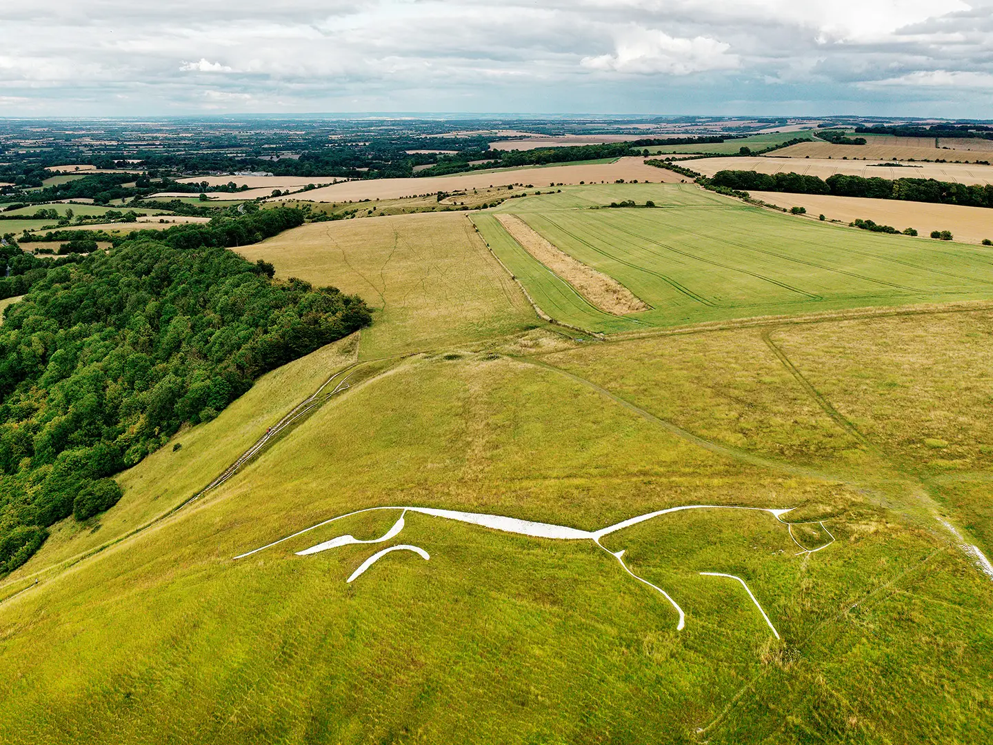
- The eight Wiltshire white horses: The trail’s defining feature is its complete link-up of Westbury, Pewsey, Marlborough, Hackpen Hill, Broad Town, Cherhill, Alton Barnes and Devizes. Each adds a short climb and a viewpoint to the loop.
- Westbury White Horse: The start and finish point on Bratton Down, and the oldest of the Wiltshire horses in its present form. It sits below Bratton Camp, an Iron Age hillfort, with broad views across the plain.
- Avebury, Silbury Hill and Windmill Hill: The route passes through the Avebury complex, part of a UNESCO World Heritage Site. For walkers, it is one of the richest prehistoric landscapes on the trail.
- Caen Hill Locks and the Kennet & Avon Canal: Near Devizes, the trail swaps open downland for a flatter canal towpath. The Caen Hill flight of 29 locks is a major engineering landmark on the route.
- Cherhill White Horse, Lansdowne Monument and Oldbury Castle: Cherhill Down combines a chalk horse, a prominent monument and the ramparts of Oldbury Castle hillfort. It is one of the strongest viewpoint sections of the walk.
- Devizes Millennium White Horse: Cut in 1999 on Roundway Hill, this is the newest of the eight horses. It gives the route a modern counterpoint to the older chalk figures elsewhere.
Challenges to expect
The main challenge is cumulative: 146.5 km over 7–9 days with repeated climbs to chalk escarpments and around 1,900 m of ascent. Underfoot, chalk and clay can become slippery after rain, and exposed downland can be windy. Navigation is helped by purple horse waymarks, but carry a map or GPS for field-path junctions. Resupply and accommodation are easiest in towns and larger villages such as Marlborough, Pewsey, Devizes and Westbury.
HikeList Score
White Horse Trail scored 91/100 on HikeList's trail-quality metrics.
See score breakdownHide breakdown
- Ideal length 98
- Balanced challenge 100
- Scenery & wildness 71
- Varied terrain 83
- Accommodation 100
- Food & support 94
- Path quality 98
- Season flexibility 89
Computed from length, challenge, scenery & wildness, terrain variety, accommodation, food & support, path quality and season flexibility.
 United Kingdom
 England
Show more data Show less
- Grassland
- Rural
- Hills
- Dirt
- Grass
- Gravel
- Guesthouses
- Hotels
- Hostels
- Campsites
- Family Friendly
- Dog Friendly On Leash
- Restrooms
- Established Campsites
- Picnic Areas
- Potable Water Sources
- Public Transport Access Points
Download Our Full Guide to White Horse Trail FREE!
Get our comprehensive guide to this hike for free. Save it for later reading or print out at home.
In these collections
Photos from hikers
Taken on the trail by people who've reviewed White Horse Trail.
White Horse Trail: The Complete Guide
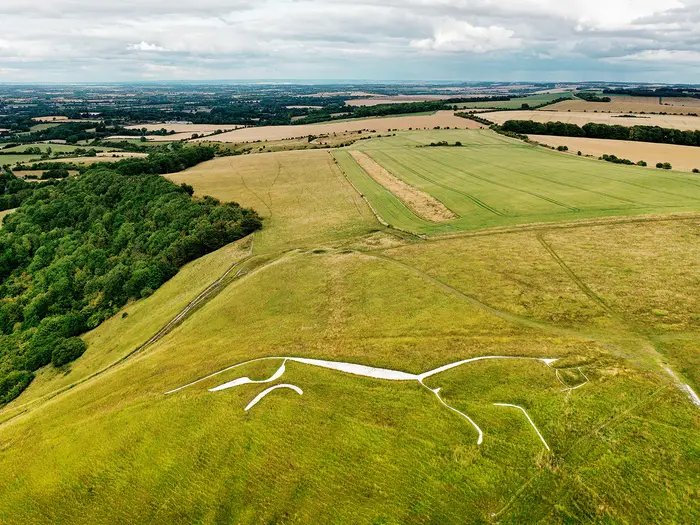 i
Image by David Matthew Lyons
i
Image by David Matthew Lyons The White Horse Trail is a distinctive Wiltshire circuit across chalk downs, vale paths and old fieldways, linking the county’s eight white-horse hill figures. It starts and finishes high on Bratton Down beside the Westbury White Horse, with the route rolling through Devizes, Alton Barnes, Cherhill, Broad Town, Hackpen Hill, Marlborough and Pewsey before returning to the escarpment.
This is not a mountain walk, but it has real long-distance character. Expect open downland, cropped fields, stiles, sunken lanes, short road links and a calmer stretch beside the Kennet & Avon Canal near Devizes.
The appeal is as much historical as scenic: Bratton Camp, Caen Hill Locks, the Avebury option, the Wansdyke alternative, Oldbury Castle and the high chalk country around Milk Hill all sit close to the line. The walk suits reasonably fit hikers who want a manageable multi-day route with frequent villages and strong landscape variety rather than wilderness.
What the trail asks for is steady pacing and proper navigation. Waymarking can be patchy, field junctions are frequent, accommodation is unevenly spaced, and the exposed downs can feel harder in wind, rain or summer heat than the modest heights suggest.
This guide covers stages, walking days, accommodation, food, transport, terrain and the common mistakes to avoid.
Stage-by-Stage Guide
The notes below follow the clockwise seven-stage itinerary in the route summary. Distances are approximate, especially around the Alton Barnes–Cherhill link where the Avebury and Wansdyke options change the total distance.
Stage 1: Westbury White Horse to Devizes — 26 km
This is a long opening day that starts high on Bratton Down beside the Westbury White Horse, below Bratton Camp, then works north through lower Wiltshire farmland towards Devizes. It is less dramatic than the later downland stages, but it sets the pattern for the trail: field paths, village links, stiles, lanes and sections where the line on the map matters more than the waymarks.
The main places on or near the route are Steeple Ashton, Keevil, Bulkington and Poulshot before the approach to Devizes. Expect a mixture of arable fields, hedged paths, byways and short road or lane links rather than continuous open downland.
Food and water should be sorted before leaving the Westbury/Bratton area, as services between the start and Devizes should not be assumed. Devizes is a proper overnight stop with the best chance of accommodation, evening food and supplies at the end of the day.
The start is awkward without a car. Westbury has a major railway station, but the White Horse is up on the escarpment; a bus such as service 87 can get you to Bratton, leaving a short uphill walk to the start, but times should be checked before travelling. Devizes has road and bus access but no railway station.
Navigation needs care from the first day. The purple White Horse Trail waymarking is patchy, field edges can be confusing, and cropped fields may not always have an obvious walked line in summer. Carry the relevant OS mapping, GPX and LDWA route directions rather than relying on signs alone.
Stage 2: Devizes to Alton Barnes / Honeystreet — 19 km
This stage gives the route one of its clearest changes of character: from town and canal-side walking to open chalk country above the Vale of Pewsey. The trail uses the Kennet & Avon Canal towpath near Devizes, with the Caen Hill locks close by, then heads towards Roundway Hill and the Devizes Millennium White Horse.
Beyond Devizes, the route passes near Bishops Cannings and the Horton / All Cannings area before reaching Alton Barnes, Alton Priors and the Honeystreet area. The Alton Barnes White Horse sits on the slope of Milk Hill, with the trail running through some of Wiltshire’s highest downland beside Milk Hill and Tan Hill.
The canal towpath is straightforward underfoot, but the later chalk sections are more exposed and can be slippery after rain. On the downs, wind and weather are felt more strongly than the modest altitude suggests.
Devizes is the place to buy food before setting out. Do not rely on regular services through the villages unless checked in advance, and carry enough water for the full stage, especially in warm weather.
Accommodation around Alton Barnes, Alton Priors and Honeystreet is more limited than in Devizes. Book ahead and be prepared to use a local taxi or pre-arranged accommodation transfer if the nearest suitable bed is off-route.
Navigation is generally helped by obvious landscape features on the open downs, but field-path junctions and the transitions on and off the canal require attention. The Alton Barnes area is also where route options and onward choices begin to matter, so check the next stage before committing to accommodation.
Stage 3: Alton Barnes to Cherhill via Avebury and Windmill Hill — 19 km
The Avebury option is the richer historic line between Alton Barnes and Cherhill, passing through the Avebury stone-circle complex and near Windmill Hill within the Stonehenge and Avebury UNESCO World Heritage Site. It is one of the most memorable stages of the whole trail, combining high chalk country, prehistoric landscape and the approach to Cherhill Down.
The alternative Wansdyke option gives a shorter overall route and follows the early-medieval earthwork across the downs instead of going via Avebury. Decide which option to take before booking accommodation or arranging baggage transfers, as the line and daily logistics differ.
Underfoot, expect a mix of open downland, tracks, field paths and village approaches. The chalk can be greasy after rain, while exposed sections can feel bleak in strong wind even though the heights are modest.
Cherhill is reached after the route’s northern sweep towards Cherhill Down, where the Cherhill White Horse, Oldbury Castle and the Lansdowne Monument form a compact group of landmarks. This is a rewarding finish, but it is not a large service centre.
Food and water availability should be treated cautiously on this stage. Avebury is the key place on the Avebury line where facilities may be possible, but opening times and availability should be checked before travelling; otherwise carry what is needed from Alton Barnes.
Accommodation at or near Cherhill is limited compared with Devizes, Marlborough and Pewsey. The A4 at Cherhill has bus access, including the Calne–Marlborough service 42, but current times should be checked before depending on it.
Navigation is particularly important because this is the stage with a significant route choice. Make sure the map, GPX and LDWA directions match the chosen option: Avebury and Windmill Hill, or the Wansdyke line.
Stage 4: Cherhill to Broad Town / Broad Hinton — 13 km
This is a shorter stage, useful after the longer opening days and before the Hackpen Hill and Marlborough Downs section. It links Cherhill with Clevancy, Clyffe Pypard, Broad Town and Broad Hinton, crossing a quieter mix of farmland, lanes and chalk-country paths.
The main landmark is the Broad Town White Horse, a smaller hill figure on the chalk scarp below Broad Town. It is a more understated stage than Avebury or the Alton Barnes downs, but it remains typical White Horse Trail walking: fields, stiles, field corners and occasional lane links.
Path conditions can vary with farming activity. In summer, cropped fields may obscure the trodden line; after rain, chalk and clay can be slippery and heavy underfoot.
Services are limited on this part of the loop. Carry food and water from the start unless specific village options have been checked in advance.
Accommodation around Broad Town and Broad Hinton is sparse. This is one of the sections where walkers commonly need to be flexible, either booking well ahead or arranging a transfer to a larger accommodation base such as Marlborough.
Road access is possible at the villages, and Cherhill has the A4 bus corridor, but onward public transport from smaller villages should not be assumed. This should be checked before travelling.
Navigation can be fiddly rather than technically difficult. The main risks are missed field exits, unclear waymarking and following the wrong field edge after a stile or lane crossing.
Stage 5: Broad Hinton / Hackpen Hill to Marlborough (Manton) — 17 km
This stage returns to more open downland, climbing through the Hackpen Hill area before turning towards Rockley, Manton and Marlborough. Hackpen Hill White Horse is the key hill figure of the day, set on the Marlborough Downs close to where the Ridgeway National Trail crosses the scarp.
The walking is a mix of exposed chalk downland, bridleways, byways, field paths and lanes. Views are broad in good weather, but there is little shelter on the open tops, so wind, rain and sun exposure all matter.
The approach to Marlborough brings the route towards Manton and the Marlborough, or Preshute, White Horse on Granham Hill above the River Kennet. This is the smallest of the eight horses and is easily missed if the day is rushed or the line is not followed carefully.
Carry food and water from Broad Hinton or your accommodation base, as dependable services should not be assumed before Marlborough. Marlborough is a strong overnight stop, with a better range of accommodation, food and resupply than the rural stages to either side.
Marlborough has no railway station, so access is by road and bus rather than train. It is, however, one of the more practical places on the route for accommodation transfers and itinerary adjustments.
Navigation on the downs is usually clearer than in cropped lowland fields, but the route is shared in places with other long-distance paths and tracks. Check signs carefully and keep the White Horse Trail line distinct from the Ridgeway and other routes.
Stage 6: Marlborough (Manton) to Pewsey — 18 km
From Marlborough and Manton, the trail heads south-west through the Kennet valley fringe and towards Oare before climbing towards Pewsey Hill and the Pewsey White Horse. This is a varied stage, with town-edge walking at the start, field paths and downland later in the day.
The Pewsey White Horse is the last white horse before the route begins its long return towards Westbury. The present figure dates from 1937 and sits above the town on the site of an earlier horse.
Underfoot, expect more field paths, stiles, tracks and short lane sections. As elsewhere on the route, wet chalk can be slippery and arable sections may be awkward when crops are high or paths have not been clearly reinstated.
Marlborough is the logical place to stock up before starting. Between Marlborough and Pewsey, do not rely on food or water without checking current options; Pewsey has the best end-of-day services.
Pewsey is one of the easiest access points on the whole trail because it sits directly on the route and has its own mainline station on the Berks & Hants line, with direct GWR trains from London Paddington and the West Country. This makes it a good joining, leaving or rest-point location.
Accommodation in Pewsey is more practical than in the smaller villages, but it should still be booked ahead on a multi-day itinerary. If using luggage transfer, Pewsey is also a sensible point to confirm arrangements for the long final stage.
Navigation is not severe, but care is needed around field-path junctions and the climb towards the Pewsey horse. Keep the map or GPX handy rather than assuming the waymarks will be present at every turn.
Stage 7: Pewsey to Westbury White Horse via Redhorn Hill — 38 km
This is by far the longest stage in the seven-day itinerary and should not be underestimated. It carries the route from Pewsey through the Charlton St Peter and Manningfords area, towards Redhorn Hill, then along the Salisbury Plain edge and back to Bratton Down and the Westbury White Horse.
The distance alone makes it a committing day. Fit walkers may complete it as planned, but many hikers will prefer to split it if suitable accommodation or transfers can be arranged. Any split point on this section should be checked before travelling, as services and accommodation are limited.
Terrain is classic end-of-route White Horse Trail: long field paths, byways, stiles, chalk tracks, open downland and short road or lane links. The final return to Bratton Down is exposed, and the finish sits high above Westbury rather than in the town itself.
Food and water should be carried for the full day unless specific intermediate options have been checked and are open. Pewsey is the last reliable place to organise supplies before setting out.
The finish at the Westbury White Horse is beside the car park on Bratton Down, off the B3098. If not finishing with a car or pre-arranged lift, plan the descent and onward travel carefully: Westbury has the railway station, while Bratton has bus access that must be checked against current timetables.
Navigation fatigue is a real issue on this stage. The route remains moderate in terrain, but after many kilometres of fields and lanes, missed stiles or indistinct field exits can cost time late in the day. Start early, carry a headtorch outside high summer, and keep enough battery for GPS navigation.
The main warnings are length, exposure, mud after rain and the scarcity of easy bail-out services. In poor weather or with a heavy pack, this stage is the point where a pre-arranged taxi, luggage transfer or split overnight can make the difference between an enjoyable finish and an overlong trudge.
Recommended Itinerary
The most practical clockwise schedule is 7 walking days, but it is uneven: the final Pewsey to Westbury White Horse stage is much longer than the rest. Most walkers who want steadier days should plan an 8-day version by splitting that last stage with a pre-booked transfer.
Distances below use the Avebury option where relevant. The Wansdyke option between Alton Barnes and Cherhill is slightly shorter overall, but daily distances should be checked against the LDWA directions, OS mapping or GPX before booking accommodation.
Standard itinerary: 7 walking days
Best for fit walkers who are comfortable with one long final day and can carry enough food and water across the quieter rural stretches.
| Day | From | To | Approx. distance | Why this stage makes sense | Services/accommodation notes |
|---|---|---|---|---|---|
| 1 | Westbury White Horse, Bratton Down | Devizes | 26 km | A long but logical opening stage from the escarpment through the early vale villages to a proper overnight town. It avoids needing accommodation in the smaller settlements between Bratton Down and Devizes. | Devizes is one of the strongest service stops on the route. The trailhead is above Westbury rather than in the town, so plan the start carefully if arriving by rail and bus. |
| 2 | Devizes | Alton Barnes / Honeystreet | 19 km | A manageable day after the longer opener, using the Kennet & Avon Canal corridor and then moving towards the Alton Barnes White Horse and the high chalk downs. | Accommodation becomes thinner after Devizes. Book Alton Barnes, Alton Priors, Honeystreet or a transfer well ahead. |
| 3 | Alton Barnes | Cherhill, via Avebury and Windmill Hill | 19 km | This is one of the richest historical days, linking the high downs near Milk Hill and Tan Hill with Avebury before continuing towards Cherhill. | Cherhill has limited overnight options. Some walkers may need to use bus or taxi links to reach accommodation off-route; current services should be checked before travelling. |
| 4 | Cherhill | Broad Town / Broad Hinton | 13 km | A shorter recovery stage after the Avebury day, taking in Cherhill Down and setting up the approach to Broad Town and Hackpen Hill. | Services are sparse. Broad Hinton and the Hackpen area often require careful accommodation planning or a transfer, particularly outside peak walking season. |
| 5 | Broad Hinton / Hackpen Hill | Marlborough, via Manton | 17 km | A well-balanced stage over the northern arc of the route, taking in Hackpen Hill and the approach to Marlborough via Manton and the Marlborough/Preshute White Horse. | Marlborough is a key accommodation and resupply stop, but it has no railway station. Arrive with accommodation booked. |
| 6 | Marlborough / Manton | Pewsey | 18 km | A moderate day through Oare and towards the Pewsey White Horse, ending at the easiest rail-access point on the trail. | Pewsey has its own station on the Berks & Hants line, making this the best place to pause, join or leave the route by public transport. |
| 7 | Pewsey | Westbury White Horse, via Redhorn Hill | 38 km | This completes the loop, but it is the hardest day on the standard schedule by distance. Start early and treat it as a full long-distance day rather than a simple finish. | Intermediate services are limited. Carry food and water, and arrange onward transport from Bratton Down or Westbury in advance. |
Slower variant: 8 walking days
Best for walkers who want the route to feel like a holiday rather than a challenge walk. The main improvement is to split the 38 km final day from Pewsey to Westbury White Horse.
| Day | From | To | Approx. distance | Why this stage makes sense | Services/accommodation notes |
|---|---|---|---|---|---|
| 1 | Westbury White Horse, Bratton Down | Devizes | 26 km | Keeps the opening logistics simple by reaching a full-service town on the first night. | If this is too long for day one, consider a 9-day plan with a break or transfer around the Steeple Ashton, Keevil, Bulkington or Poulshot part of the route. Exact distances and overnight options should be checked before booking. |
| 2 | Devizes | Alton Barnes / Honeystreet | 19 km | A comfortable stage leaving Devizes and moving onto the downs. | Book early; accommodation is much thinner than in Devizes. |
| 3 | Alton Barnes | Cherhill, via Avebury and Windmill Hill | 19 km | Allows time for the Avebury option without turning the day into a forced march. | Cherhill accommodation and bus links are limited; check current options before travelling. |
| 4 | Cherhill | Broad Town / Broad Hinton | 13 km | A deliberately short middle day, useful if weather is poor on the exposed chalk or if accommodation dictates a slower rhythm. | Broad Town, Broad Hinton and the Hackpen area need advance planning. Transfers to Marlborough may be necessary. |
| 5 | Broad Hinton / Hackpen Hill | Marlborough, via Manton | 17 km | Keeps the Hackpen and Marlborough section at a sensible length. | Marlborough is the best overnight base on this part of the route, despite having no station. |
| 6 | Marlborough / Manton | Pewsey | 18 km | A straightforward stage to a useful rail town, with the Pewsey White Horse before the long return arc. | Pewsey works well for resupply, accommodation and public transport. |
| 7 | Pewsey | Charlton St Peter / the Manningfords / Redhorn Hill access area | Check official mapping before booking | Splits the otherwise very long final stage and makes the return to Westbury more manageable. | This is primarily a logistics split, not a guaranteed accommodation stop. Expect to arrange a taxi, lift or off-route overnight; this should be checked before travelling. |
| 8 | Charlton St Peter / the Manningfords / Redhorn Hill access area | Westbury White Horse, Bratton Down | Check official mapping before booking | Leaves a shorter final walk back to Bratton Down and the Westbury White Horse. | Arrange onward transport from the escarpment in advance, especially if finishing late in the day. |
Faster variant: 6 walking days
Best for strong, efficient walkers who are used to back-to-back long days, light packs and rural navigation. This version keeps the same broad line but combines the two short northern stages.
| Day | From | To | Approx. distance | Why this stage makes sense | Services/accommodation notes |
|---|---|---|---|---|---|
| 1 | Westbury White Horse, Bratton Down | Devizes | 26 km | A direct first push to a major service town. | Devizes is the sensible first overnight for a fast schedule. |
| 2 | Devizes | Alton Barnes / Honeystreet | 19 km | Moderate distance after day one, but still covers important ground towards the high downs. | Book accommodation or transfers ahead; options are limited. |
| 3 | Alton Barnes | Cherhill, via Avebury and Windmill Hill | 19 km | Keeps the Avebury section intact without overloading the day. | Cherhill logistics need checking before travel. |
| 4 | Cherhill | Marlborough, via Broad Town, Broad Hinton, Hackpen Hill and Manton | 30 km | Combines the 13 km Cherhill to Broad Town/Broad Hinton stage with the 17 km Broad Hinton/Hackpen Hill to Marlborough stage. This is the obvious compression point for a faster itinerary. | Long rural day with limited services between endpoints. Marlborough should be booked in advance. |
| 5 | Marlborough / Manton | Pewsey | 18 km | A shorter day before the longest final stage. | Pewsey is the best rail and resupply point on the trail. |
| 6 | Pewsey | Westbury White Horse, via Redhorn Hill | 38 km | A demanding finish that suits only fit walkers happy with a long day on field paths and downland. | Carry enough food and water, and do not rely on finding services en route. Plan transport from Bratton Down or Westbury before setting off. |
Planning the Route
How many days to allow
Most walkers should plan the White Horse Trail as a 7–9 day walk, with 8 days of walking being the most comfortable default. A 7-day itinerary is possible, but it tends to create at least one very long day — notably the Pewsey to Westbury White Horse leg, which is around 38 km in the sample schedule.
Fit walkers can complete the loop in 6–7 days, but that turns a moderate lowland trail into a sustained endurance walk with less time for the white horses, Avebury, the canal and the hillforts. A slower 8–9 day plan is usually better if accommodation, transport connections or poor weather need to be managed carefully.
The LDWA splits the route into 10 sections, which is useful for navigation and section-walking, but those sections do not automatically match overnight stops. Accommodation availability is the main factor that shapes a practical itinerary.
Let accommodation dictate the itinerary
The towns are the easiest places to plan around: Devizes, Marlborough, Pewsey and Westbury have the best spread of services. Between them, options can be thin, especially around the downland and village sections.
Alton Barnes / Honeystreet, Cherhill, Broad Town, Broad Hinton and Hackpen Hill need early planning. Some itineraries around Broad Hinton or Hackpen may require a transfer, often back towards Marlborough, rather than a straightforward overnight exactly on the line of the trail.
Book accommodation well ahead, especially if walking in spring, summer or early autumn. If using luggage transfer, confirm which overnight stops can be served before fixing the walking stages.
Clockwise, anti-clockwise and where to start
The route can be walked either clockwise or anti-clockwise. The common clockwise order from Westbury White Horse runs towards Devizes, Alton Barnes, Cherhill, Broad Town, Hackpen Hill, Marlborough, Pewsey and back to Westbury.
Clockwise is a sensible choice if using the LDWA clockwise directions and the standard stage pattern. Anti-clockwise is equally possible, but the accommodation and transport plan should be rebuilt rather than simply reversed.
Although the official loop starts and finishes at the Westbury White Horse on Bratton Down, Pewsey is often the simplest rail access point because the trail passes through the town and it has a mainline station. Westbury is also well connected by rail, but the actual trailhead on Bratton Down is above the town and needs onward travel to Bratton, followed by an uphill walk to the White Horse.
Avebury option or Wansdyke option
The main planning choice is the link between Alton Barnes and Cherhill. The Avebury option makes the full route around 153 km / 95 miles and passes through the Avebury and Windmill Hill prehistoric landscape.
The Wansdyke option is slightly shorter at around 149 km / 93 miles and follows the early-medieval bank and ditch across the downs. It is the more direct high-level alternative, but still needs careful navigation and weather awareness.
Choose the Avebury route if the World Heritage landscape is a priority and the slightly longer distance fits the schedule. Choose the Wansdyke route if keeping the day shorter matters more, or if the itinerary is already tight.
Shortening, splitting and section hiking
Because the trail is circular, it can be joined at several points rather than walked only from Westbury. Pewsey is the strongest option for rail-based access; Devizes and Marlborough work better with buses or taxis because they have no railway station.
Section hiking is practical, but it needs more planning than a linear trail with frequent stations. Useful access points include Westbury, Pewsey, Devizes, Marlborough and the A4 corridor near Cherhill, but current bus times and taxi availability should be checked before travelling.
The LDWA also documents a short cut between the Pewsey and Alton Barnes horses, allowing the route to be split into two shorter circular walks. This can be useful if the full loop is too much for one trip, or if accommodation gaps make a continuous walk awkward.
Food, water and resupply
Do not assume every village has reliable food or resupply. The dependable service centres are the larger towns, especially Devizes, Marlborough, Pewsey and Westbury.
Carry enough food and water for a full day on the more rural sections, particularly where the route crosses open chalk downland, arable fields and small villages. In warm weather the exposed downs around Milk Hill, Tan Hill, Cherhill Down, Hackpen Hill and Pewsey Hill can feel hotter and drier than the map suggests.
Pub and shop opening times can be limited in smaller places. This should be checked before travelling, especially for midweek walking or out-of-season itineraries.
Navigation matters more than the altitude
The White Horse Trail is not technically difficult, but it is not a route to follow by waymarks alone. Purple White Horse Trail waymarking is patchy, and the route uses many field paths, stiles, byways, bridleways, sunken lanes and short road links.
Carry OS mapping and the LDWA route directions or GPX. The relevant OS Explorer maps are 130, 143, 156, 157 and 169; Landranger 173 and 184 also cover the route at smaller scale.
Navigation is most likely to slow walkers in cropped fields, at field-edge junctions and where paths cross working farmland. The LDWA directions should also be checked for current farm or path diversions before setting off.
Weather and ground conditions
This is open chalk-country walking, so weather affects the route more than the modest height suggests. The downland tops can be windy and exposed, while chalk and clay can become slippery or waterlogged after rain.
Summer brings longer days but also cropped fields, heat exposure and greater need to carry water. Spring and autumn are often good walking seasons, but wet spells can make field paths slow and muddy.
A lightweight waterproof, sun protection, spare warmth and footwear with decent grip are more important than mountain kit. The route is low-level, but long exposed sections make poor-weather planning worthwhile.
Transport planning
If starting at Westbury White Horse, the rail journey normally gets you only as far as Westbury station. From there, a bus such as service 87 runs towards Bratton, leaving a short but noticeable uphill approach to the trailhead on Bratton Down. Current bus times should be checked before travelling.
Pewsey is the easiest on-route rail access point, with direct GWR trains on the Berks & Hants line. It is a good alternative start or finish point for section hikers.
Marlborough and Devizes do not have railway stations, so onward travel depends on buses or taxis. Services such as the Calne–Marlborough route 42, which stops at Cherhill on the A4, may help with access to the northern part of the trail, but current timetables should be checked before booking an itinerary.
Towns, Villages and Overnight Stops
Accommodation on the White Horse Trail is uneven. Westbury, Devizes, Marlborough and Pewsey are the most useful overnight bases because they have the best mix of accommodation, onward transport and town services. Between them, the route crosses small villages, downland and farm country where beds, evening meals and resupply points can be sparse.
Book accommodation well ahead, especially around Alton Barnes, Cherhill, Broad Town, Broad Hinton and Hackpen Hill. On some itineraries, a taxi, luggage-transfer provider or accommodation transfer is the practical way to bridge gaps between the path and the nearest bed.
| Route area | Overnight value | Practical notes |
|---|---|---|
| Westbury / Bratton Down | Good for start or finish | Rail access at Westbury; the actual trailhead is up on Bratton Down beside the Westbury White Horse car park. |
| Devizes | Very useful | One of the main overnight towns; good stage end after the Westbury start. No railway station. |
| Alton Barnes / Honeystreet | Useful but limited | Logical stop between Devizes and Cherhill; accommodation is sparse and should be booked early. |
| Avebury | Optional stop | Useful if splitting the Avebury variant more gently; accommodation and food arrangements should be checked before travelling. |
| Cherhill | Useful but limited | Good stop after the Avebury or Wansdyke section; bus access on the A4 is useful, but beds may be limited. |
| Broad Town / Broad Hinton | Limited but strategically important | Helps break the northern arc of the route; transfers may be needed, particularly around Hackpen. |
| Marlborough / Manton | Very useful | One of the best overnight and resupply bases on the route; no railway station. |
| Pewsey | Very useful | Directly on the trail and has a mainline station, making it the easiest rail access point. |
| Pewsey to Westbury return leg | Sparse | Long final section on the standard 7-day schedule; arrange food, water and any escape transport in advance. |
Westbury White Horse / Bratton Down and Westbury
The loop starts and finishes at the Westbury White Horse on Bratton Down, beside the car park on the escarpment below Bratton Camp. This is an excellent symbolic trailhead, but it is not a town-centre start: the practical services are down in Westbury or in Bratton.
Westbury is one of the best places for a pre-walk or post-walk night because it has the strongest transport link at this end of the route. Westbury railway station is a major rail junction, with services on the London Paddington, Bristol, South West and Wessex Main Line corridors.
From Westbury, a bus such as service 87 runs to Bratton, leaving a short walk and climb up to the White Horse. Bus times and the exact walking line from Bratton to the escarpment should be checked before travelling, especially if starting early or finishing late.
If driving, the trailhead car park is off the B3098 on Bratton Down. Do not assume food, water or toilets at the hilltop start; sort final supplies in Westbury or another town before going up to the White Horse.
Steeple Ashton, Keevil, Bulkington and Poulshot
These villages come early on the clockwise route between Westbury and Devizes. They are useful as navigation and rest points across the lower farmland section, but they are not the main accommodation anchors for most itineraries.
Do not build a resupply plan around these villages unless a specific pub, shop or accommodation has been booked or checked in advance. Opening hours and availability in small Wiltshire villages can be limited, and this should be checked before travelling.
For most walkers, this stretch is best treated as a through-walk to Devizes. Carry food and water from the start rather than relying on finding services part-way through the day.
Devizes
Devizes is one of the key overnight stops on the White Horse Trail and the usual first major town on a clockwise itinerary from Westbury. It is a sensible end point after the long opening stage and a good place to reset before the canal and downland sections to the east.
Accommodation is more plentiful here than in the surrounding villages, with the general mix on the route including B&Bs, inns, small hotels and guesthouses. Devizes is also one of the better places to organise evening food, breakfast supplies and packed lunch arrangements, though individual opening hours should still be checked.
The route’s Devizes section uses the Kennet & Avon Canal towpath and passes the Caen Hill Locks area before heading towards Roundway Hill and the Devizes Millennium White Horse. This makes Devizes a strong stop for walkers who want a less rushed start to the second day.
Devizes has no railway station. Access is by road and bus, so onward transport should be planned rather than assumed.
Roundway Hill and Bishops Cannings area
Roundway Hill is important for the trail because it carries the Devizes Millennium White Horse, but it is not usually an overnight base in its own right. It sits on the edge of Devizes and is better treated as part of the Devizes stage.
The route then continues towards the Bishops Cannings area and the Vale of Pewsey side of the walk. Services are thinner once away from Devizes, so leave town with the food and water needed for the day.
Bishops Cannings, Horton and All Cannings are near-route reference points rather than guaranteed service stops. Any pub, shop, bus or accommodation use here should be checked before travelling.
Alton Barnes, Alton Priors and Honeystreet
Alton Barnes and Alton Priors sit below the high chalk downs around the Alton Barnes White Horse, Milk Hill and Tan Hill. This is one of the most important overnight areas on the route because it breaks the walk between Devizes and Cherhill.
Accommodation is much thinner here than in Devizes, Marlborough or Pewsey. Expect a small supply of rural B&B-style options rather than a large choice, and book early. If nothing suitable is available, a taxi or accommodation transfer may be needed.
Honeystreet is commonly used in stage planning for this part of the trail. It can be a practical stop or pick-up point, but food and accommodation availability should be checked before travelling.
This is not a place to arrive without a plan. The surrounding downland is exposed, the next day may involve either the Avebury option or the Wansdyke option, and resupply opportunities are not as dependable as in the main towns.
Avebury and Windmill Hill
Avebury is on the longer Avebury variant between Alton Barnes and Cherhill. It is one of the most attractive places to break the route if time allows, because the trail passes through the Avebury stone-circle landscape and near Windmill Hill.
As an overnight stop, Avebury is useful but should not be assumed to have the same capacity as the larger towns. Accommodation, evening meals and opening hours should be checked before travelling, especially in busy seasons.
Avebury is particularly helpful for walkers who want to avoid making the Alton Barnes to Cherhill section too compressed. If walking a faster schedule, it may simply be a substantial mid-stage pause rather than an overnight.
Wansdyke option
The Wansdyke alternative is a high-level link rather than a village-based stopping option. It follows the early-medieval earthwork across the downs and bypasses the Avebury-specific line.
Accommodation planning is broadly the same as for the Avebury section: the practical overnight anchors remain Alton Barnes or the Cherhill side, with any intermediate transport or pick-up arranged in advance. Do not expect the Wansdyke option to solve accommodation gaps.
Cherhill
Cherhill is a natural overnight or stage-end point after the Alton Barnes section, particularly if taking the Avebury option. The route here is notable for the Cherhill White Horse, Oldbury Castle and the Lansdowne Monument on Cherhill Down.
Accommodation in and around Cherhill is more limited than in Devizes or Marlborough, so it is best booked well ahead. If beds are not available locally, look at arranging a transfer to a larger nearby base rather than stretching the day unexpectedly.
Cherhill has a useful transport note: the Calne–Marlborough service 42 stops at Cherhill on the A4. Current bus times and stop details should be checked before travelling.
For food and resupply, treat Cherhill as a planned stop rather than an assumed one. Confirm evening meal options with accommodation or check local opening hours before committing to the stage.
Clevancy, Clyffe Pypard and Broad Town
This part of the northern arc links Cherhill towards Broad Town and Broad Hinton. Broad Town is important because of the Broad Town White Horse, but the area is not as straightforward for accommodation as the main towns.
Broad Town can work as a stage end on shorter walking days, but beds and evening food are limited enough that arrangements need to be made before arrival. Clevancy and Clyffe Pypard are better treated as route points unless accommodation has been specifically booked.
This is a section where luggage transfer and local taxis can make the itinerary much easier. Without them, be careful not to create a stage that ends in a village with no confirmed bed or meal.
Broad Hinton and Hackpen Hill
Broad Hinton is a useful planning point before or after Hackpen Hill, where the trail reaches the Hackpen White Horse on the Marlborough Downs. This is a scenic but potentially awkward overnight area because accommodation is thin.
Some walkers need a transfer from the Broad Hinton or Hackpen area back to Marlborough or another accommodation base. This is one of the clearest places on the White Horse Trail where booking logistics matter as much as walking fitness.
Do not rely on turning up and finding a bed nearby. Confirm the overnight stop, evening meal, breakfast and any morning return transfer before starting the stage.
Rockley, Manton and Marlborough
After Hackpen Hill, the route continues towards the Marlborough side of the trail, passing near Rockley and entering Marlborough via Manton. Manton is particularly relevant because the trail approaches the Marlborough, or Preshute, White Horse on Granham Hill from this side.
Marlborough is one of the best overnight bases on the route. Accommodation is more plentiful than in the surrounding villages, and it is a sensible place to resupply, eat properly and reorganise kit before the walk towards Pewsey.
Marlborough has no railway station, so public transport access is by bus. If using Marlborough as a transfer base for Broad Hinton, Hackpen or other rural sections, arrange the taxi or accommodation lift in advance.
For many walkers, Marlborough is the most useful mid-route reset after several nights of thinner rural accommodation. It is also a sensible place to add a rest or half-day if walking a more relaxed 8- or 9-day schedule.
Oare
Oare lies on the Marlborough to Pewsey section. It is a useful route point but not one of the main overnight centres in the standard itinerary.
Treat Oare as part of the day’s walk unless accommodation or food has been specifically arranged. The stronger practical stop on this leg is Pewsey, which has both accommodation options and rail access.
Carry what is needed from Marlborough for the day. Field paths, stiles and cropped farmland can slow progress, so avoid planning a tight connection in Pewsey without allowing for navigation and terrain.
Pewsey
Pewsey is one of the most practical stops on the entire White Horse Trail. It sits directly on the route, has accommodation in the town, and has its own station on the Berks & Hants line with direct GWR trains from London Paddington and the West Country.
For walkers using public transport, Pewsey is the easiest access point on the trail. It is also a strong place to start or finish a section-hike, or to split the full circuit into shorter blocks.
The Pewsey White Horse on Pewsey Hill is the last of the eight horses before the route turns back towards the Westbury side of the loop. If following the common 7-day schedule, the next stage to Westbury White Horse is long, so Pewsey is the place to make firm arrangements for food, water, luggage and onward transport.
Accommodation is more available here than in the villages either side, but it should still be booked ahead. Confirm breakfast times or packed-lunch options if starting early for the final long section.
Charlton St Peter, the Manningfords and Redhorn Hill
The route from Pewsey towards Westbury passes near Charlton St Peter and the Manningfords before reaching the Redhorn Hill and Salisbury Plain edge section. These are useful route references, but they are not the main service centres for the trail.
On the standard itinerary this is the most demanding planning day because the Pewsey to Westbury White Horse leg is long. There are no major overnight towns listed between Pewsey and the finish, so any intermediate stop, taxi pick-up or shortening option must be arranged in advance.
Carry enough food and water for a full day, and do not assume village services will be open or available. This should be checked before travelling.
Bratton Down and the return to Westbury White Horse
The final approach returns to Bratton Down and the Westbury White Horse, closing the loop at the same hilltop where the trail began. The finish is exposed downland rather than a town-centre endpoint, so onward transport still needs planning.
If finishing by public transport, allow time to walk down to Bratton for the bus connection towards Westbury, or pre-arrange a taxi. Bus times should be checked before travelling, particularly on Sundays, bank holidays or late afternoons.
If staying overnight after the finish, Westbury is the most practical nearby base because of its railway station and wider town services. The White Horse car park is useful for access, but it should not be treated as a reliable place for post-walk food, water or public transport without prior checks.
Getting to the Start
The White Horse Trail starts at the car park on Bratton Down beside the Westbury/Bratton White Horse, above Westbury and Bratton, off the B3098. It is a convenient landmark by car, but slightly awkward by public transport because the start sits high on the escarpment rather than in the town.
By train
Westbury is the nearest railhead for the official start. It is a major railway station with services on the Wessex Main Line and at the Berks & Hants junction, with connections including London Paddington, Bristol and the South West.
From Westbury station, the trailhead is not on the valley floor: the White Horse is up on Bratton Down, below Bratton Camp. Most walkers arriving by rail should either take a bus or taxi towards Bratton, then expect a short uphill approach to the car park and White Horse.
Pewsey station is also directly on the route and has GWR trains from London Paddington and the West Country. It is the easiest rail access point for joining the trail mid-route, but it is not the official Westbury White Horse start.
Train times and engineering works should be checked before travelling.
By bus
A bus from Westbury towards Bratton, such as service 87, gives the closest public-transport approach to the start. From Bratton, you still need to walk uphill to the White Horse on Bratton Down, so allow time and avoid treating the bus stop as the trailhead.
Bus frequencies can be limited, especially at weekends and outside commuter periods. This should be checked before travelling, particularly if aiming to start walking the same day after a rail journey.
If the bus times do not work, a local taxi from Westbury station is the simplest fallback. Pre-booking is sensible if arriving early, late, on a Sunday or with a large pack.
By car
The start is the car park on the escarpment beside the Westbury/Bratton White Horse, off the B3098, with Bratton Camp above. This is the most straightforward way to reach the official start point.
Do not assume the trailhead car park is suitable for leaving a vehicle for a full 7–9 day circuit. Long-stay rules, any local restrictions and security should be checked before travelling. If in doubt, arrange parking through accommodation in Westbury or use a taxi to the start.
Because the walk is circular, returning to the same trailhead is logistically simple if a car has been left legally and safely. The final approach returns across the Salisbury Plain edge and Bratton Down to the Westbury White Horse.
From the nearest airport
There is no airport transfer that drops you close to the trailhead. For visitors flying in, the practical plan is to reach the rail network and travel to Westbury, commonly via London Paddington if arriving through London.
Allow a generous connection window if combining a flight, cross-city transfer, train to Westbury and bus or taxi up to Bratton Down on the same day. Current rail and onward transport times should be checked before booking flights.
Where to stay before starting
Westbury is the most practical overnight base before starting from the White Horse, especially for walkers arriving by train. Staying in or near Westbury also makes it easier to arrange a taxi up to Bratton Down in the morning.
Bratton is closer to the hill, but accommodation options should not be assumed. The wider route has uneven accommodation coverage, with better choice in towns such as Westbury, Devizes, Marlborough and Pewsey than in smaller villages.
Book the first night before travelling, and confirm whether the accommodation can help with taxi arrangements or parking if needed. This is particularly important if starting early or walking with luggage-transfer arrangements.
Getting Home from the Finish
The White Horse Trail finishes where it starts: at the Westbury White Horse car park on Bratton Down, above Westbury and Bratton. This is useful for anyone returning to a parked car, but less convenient by public transport because the finish is up on the escarpment rather than in the town.
By train
Westbury is the key railhead for leaving the finish. Westbury railway station is a major Wiltshire station with services towards London Paddington, Bristol and the South West, and it sits on the Wessex Main Line and the Berks & Hants route.
From the White Horse, you first need to get down from Bratton Down to Westbury or Bratton. Do not assume there will be onward transport waiting at the hilltop car park, especially late in the day; arrange a taxi in advance or time the descent to meet a bus connection.
If finishing on the long final stage from Pewsey, build in a realistic margin for the last section across Redhorn Hill and Bratton Down. Missing an evening train from Westbury may leave a long wait or require a taxi onward, depending on the day and timetable. Train times should be checked before travelling.
By bus
A bus connection, such as service 87, links Westbury and Bratton. From the finish at the White Horse, this usually means walking down from Bratton Down to Bratton and then taking the bus towards Westbury for the railway station or town accommodation.
Bus services in rural Wiltshire can be limited, with fewer options in the evening, on Sundays and on bank holidays. Treat the bus as a planned connection rather than a fallback, and check the current timetable before travelling.
By car/taxi
If a car has been left at the Westbury White Horse car park, the circular nature of the trail makes the finish straightforward. Before leaving a vehicle for several days, check current parking rules and any local restrictions.
For rail-based walkers, a pre-booked taxi is the simplest way to leave the hilltop finish, particularly in poor weather, after dark or after the long Pewsey-to-Westbury final day. Arrange the pickup point clearly as the Westbury White Horse car park on Bratton Down, off the B3098, as this is not the same as central Westbury.
A taxi can also remove the need to descend to Bratton for the bus. This is the safer plan if the day has run late or if the final stage has taken longer than expected.
From the nearest airport
The practical onward connection from the finish is by rail from Westbury rather than directly by airport transport. For flights, plan the journey around getting from the Westbury White Horse to Westbury station, then connecting through the rail network towards the chosen airport or mainline interchange.
Airport transfers and late-day rail connections are timetable-dependent and should be checked before booking flights. Allow extra time if finishing the trail on the same day as travelling onward.
Where to stay at the finish
Westbury is the most practical place to stay after finishing, because it has both town accommodation and the railway station for onward travel. Staying overnight is sensible if the final stage from Pewsey is walked as one long day, if relying on public transport, or if onward trains would require a tight evening connection.
Accommodation should be booked ahead, particularly at weekends and during busy walking periods. If using a taxi from the finish, arrange it before setting out for the final day rather than trying to organise it from Bratton Down at the end of the walk.
Which Direction Should You Walk?
The White Horse Trail can be walked either clockwise or anti-clockwise, and the LDWA provides route directions for both. In practice, clockwise is the most straightforward choice for most walkers because it matches the common stage order: Westbury White Horse > Devizes > Alton Barnes > Cherhill > Broad Town / Broad Hinton > Hackpen Hill > Marlborough > Pewsey > Westbury White Horse.
Clockwise vs anti-clockwise
| Direction | Best for | Main drawbacks |
|---|---|---|
| Clockwise | Following the standard stage flow; easier use of common itineraries; a strong finish back over Bratton Down to the Westbury White Horse | The final Pewsey to Westbury stage is long if walked as one day in a 7-day schedule |
| Anti-clockwise | Walkers with a bespoke accommodation plan, or anyone wanting to tackle the Pewsey–Westbury section early | Less aligned with the usual published stage order; the long Westbury–Pewsey leg can come immediately if starting at Westbury |
Transport does not strongly favour either direction
Because the route is a loop, direction makes little difference to overall transport planning. The traditional start and finish is the Westbury White Horse on Bratton Down, but this is awkward by public transport: Westbury has a major railway station, then you need onward local transport towards Bratton and a short uphill approach to the escarpment.
Pewsey is the easiest rail access point actually on the trail, with its own station on the Berks & Hants line. If starting at Pewsey rather than Westbury, the same clockwise-versus-anti-clockwise considerations apply, but the stage plan will need adjusting around accommodation and luggage transfer.
Scenery and route rhythm
Clockwise gives the route a logical progression. It begins at the Westbury horse on Bratton Down, crosses villages and farmland towards Devizes, picks up the Kennet & Avon Canal near Caen Hill, then works onto the northern downs through Alton Barnes, Avebury or the Wansdyke option, Cherhill, Broad Town, Hackpen Hill and Marlborough before returning through Pewsey and the Salisbury Plain edge.
Anti-clockwise is perfectly workable, but it front-loads the Pewsey and Marlborough side of the loop and leaves Devizes, the canal towpath and the lower western approach until later. The walking is not technically harder, but the journey can feel less natural if using the common White Horse Trail stage sequence.
Climbs, wind and exposure
There is no decisive climbing advantage in either direction. The trail repeatedly climbs onto chalk escarpments and open downland — including Bratton Down, Roundway Hill, Milk Hill, Hackpen Hill and Cherhill Down — so the effort is spread around the loop rather than concentrated in one direction.
The exposed downland sections can be windy in any direction. Route choice will not reliably put the wind behind you, so weather planning is more important than direction: carry layers, expect little shelter on the tops, and take extra care with navigation in poor visibility.
Accommodation flow
Clockwise is generally easier to organise because it follows the most familiar overnight pattern through Devizes, Alton Barnes / Honeystreet, Cherhill, Broad Town / Broad Hinton, Marlborough and Pewsey. Even so, accommodation is thin between the main towns, and some stages around Broad Hinton, Hackpen Hill and the Marlborough Downs may require transfers.
Anti-clockwise uses the same settlements in reverse, so it is not inherently worse, but it is more likely to need a custom booking plan. If using a luggage-transfer company or walking-holiday operator, follow the direction and overnight stops they support unless there is a clear reason to alter them.
Recommended direction
Walk the White Horse Trail clockwise unless accommodation availability or transport makes the reverse more convenient. It best matches the established stage order, gives a satisfying final return to the Westbury White Horse on Bratton Down, and is the simplest direction for most independent walkers to plan.
Accommodation Along the Route
Accommodation on the White Horse Trail is workable for an inn-to-inn itinerary, but it needs more planning than the modest mileage suggests. The main towns — Westbury, Devizes, Marlborough and Pewsey — have the strongest choice, while several of the downland and Vale of Pewsey sections rely on a small number of B&Bs, pubs with rooms, farm accommodation, bunkhouse-style options or campsites.
The key pinch points are around Alton Barnes / Honeystreet, Cherhill, Broad Town / Broad Hinton and Hackpen Hill. These places make logical overnight stops on paper, but availability can be thin, and some walkers will need a short taxi transfer to or from Marlborough, Pewsey or another nearby base. Book accommodation before committing to daily stages.
Best overnight stops
A practical 7–9 day walk usually uses the larger towns where possible, then bridges the thinner sections with early booking or transfers. Devizes is the natural first major overnight stop if starting from the Westbury White Horse; Marlborough and Pewsey are the easiest later-stage bases. Westbury is useful for the night before or after the walk, though the actual start is up on Bratton Down rather than in the town centre.
The final Pewsey to Westbury White Horse stage is long if walked in one day. Walkers wanting shorter days should look carefully at accommodation or transfer options around the Manningfords, Redhorn Hill and the Salisbury Plain edge. This should be checked before travelling.
| Place | Accommodation level | Best for | Notes |
|---|---|---|---|
| Westbury / Bratton Down | Good in Westbury; limited at the down | Pre-walk and post-walk nights | The loop starts and finishes at the Westbury White Horse on Bratton Down, above Westbury. Staying in Westbury is more practical than expecting accommodation at the hilltop start. |
| Steeple Ashton, Keevil, Bulkington, Poulshot | Limited | Breaking up the Westbury–Devizes leg | These villages sit on the early part of the route, but accommodation should not be assumed. Useful only with advance booking or a planned transfer. |
| Devizes | Good | First major overnight, resupply, rest logistics | One of the strongest accommodation bases on the trail, with town services and access to the Kennet & Avon Canal section. A reliable place to anchor an itinerary. |
| Bishops Cannings, Horton, All Cannings | Limited | Shortening the Devizes–Alton Barnes section | Rural accommodation may exist in this corridor, but choice is thin compared with Devizes or Pewsey. Book before building a stage around it. |
| Alton Barnes / Alton Priors / Honeystreet | Limited | Overnight near the Alton Barnes White Horse and Milk Hill | A logical stop after Devizes, but not a large accommodation centre. Early booking is important, especially if walking without transfers. |
| Avebury option | Limited | Optional overnight or shorter stage planning | The Avebury variant is attractive for walkers who want more time in the prehistoric landscape, but accommodation capacity should be checked before relying on it. |
| Cherhill | Limited | Overnight after the Avebury or Wansdyke link | Useful on the northern arc of the route near Cherhill Down, Oldbury Castle and the Lansdowne Monument, but choice is limited. Transfers may be simpler than forcing an overnight here. |
| Clyffe Pypard, Broad Town, Broad Hinton | Limited | Splitting the Cherhill–Hackpen–Marlborough section | This is one of the main accommodation pinch points. Around Broad Hinton and Hackpen, some itineraries may need a taxi transfer back to Marlborough or another base. |
| Hackpen Hill / Rockley | None to limited | Route passage rather than an overnight base | Do not rely on accommodation directly at Hackpen Hill. Plan this section around Broad Hinton, Marlborough or a pre-arranged transfer. |
| Manton / Marlborough | Good | Strong overnight base, resupply, transfer hub | Marlborough is one of the best places on the route for accommodation choice. It is especially useful for solving the Broad Hinton / Hackpen gap. |
| Oare | Limited | Shortening Marlborough–Pewsey | Possible as a stage-planning point, but Pewsey is the stronger accommodation base. Check availability before treating Oare as an overnight stop. |
| Pewsey | Good | Overnight before the final leg, rail access, resupply | A key trail town with its own railway station on the route. A practical place to pause, finish a section, or restart the walk. |
| Charlton St Peter, the Manningfords, Redhorn Hill | Limited | Splitting the long Pewsey–Westbury return | Accommodation is sparse on this closing stretch. If the full Pewsey–Westbury White Horse day is too long, arrange lodging or taxi transfers in advance. |
Booking strategy
Book the village nights first, then fill in the town nights around them. Devizes, Marlborough, Pewsey and Westbury give the most flexibility, but the smaller overnight points can determine the whole itinerary.
Weekend and holiday-period availability can be tight because several stages depend on only a few suitable places. This matters more here than on trails with a continuous chain of larger villages. Confirm current availability, cancellation terms and whether evening meals are available before booking.
Luggage transfer and taxi transfers
The White Horse Trail works well with luggage transfer if accommodation is booked as a continuous walking holiday. Operators commonly sell the route as an 8-day walk with 9 nights, which suits walkers who want to avoid carrying full overnight gear.
Independent walkers should still expect to use taxis or accommodation transfers in a few places. The most likely awkward gaps are around Alton Barnes / Honeystreet, Cherhill, Broad Town / Broad Hinton, Hackpen Hill and the long Pewsey to Westbury White Horse return. Taxi availability and pick-up points on rural lanes should be arranged before travelling.
Camping and budget options
The route has a mixed accommodation pattern, including campsites and the occasional hostel or bunkhouse-style option, but these are not evenly spaced. A camping itinerary needs the same careful stage planning as a B&B itinerary, because some downland sections have few practical overnight choices.
Do not assume that every village has a campsite or budget bed. Where camping is part of the plan, use bookable sites and check location, access and food options before setting out.
Camping and Wild Camping
Camping is possible on the White Horse Trail, but it is not the easiest way to do the route. This is a farmed, lowland Wiltshire walk with long stretches across private fields, chalk downs, villages and lanes, rather than a route with regular walker-oriented campsites at every natural stopping point.
Most camping itineraries need more planning than a B&B or inn-based walk. Expect to search beyond the exact line of the trail, contact sites in advance, and use short transfers or taxis where the day’s end does not match a suitable campsite.
Campsites and camping practicality
The most sensible places to look for formal camping are around the larger settlements and service points on or near the route, especially Westbury/Bratton, Devizes, the Vale of Pewsey, Marlborough/Manton and Pewsey. Smaller villages such as Alton Barnes, Cherhill, Broad Town, Broad Hinton and Oare have fewer services, so camping options may be limited or require a walk off-route.
Do not assume a campsite will be available at each stage end. The White Horse Trail is often walked using B&Bs, inns, guesthouses and luggage transfer because accommodation is unevenly spaced, and the same issue applies more strongly to camping.
A camping plan works best if you are flexible with stage lengths. The standard 7-day outline includes a very long final day from Pewsey back to Westbury White Horse, so campers may prefer to split the route differently if suitable overnight options can be arranged. This should be checked before travelling.
Wild camping legality and reality
There is no general right to wild camp on private farmland and downland in Wiltshire without the landowner’s permission. The White Horse Trail crosses working farms, cropped fields, grazing land, historic sites and open chalk escarpments, so discreet “just pitch anywhere” camping should not be treated as acceptable.
If wild camping is part of the plan, arrange permission in advance from the relevant landowner or land manager. In practice, this can be difficult on a route with many field boundaries and fragmented land ownership, so most walkers should plan around formal campsites, pubs or accommodation instead.
Avoid camping on or close to the white horse figures, hillforts, barrows, the Avebury landscape, the Wansdyke, access tracks, field margins with crops, livestock fields, and any place where a tent would be visible from houses, roads or monuments. The Avebury option passes through a highly sensitive prehistoric landscape, and camping around monuments or earthworks is not appropriate.
Best sections for a camping approach
The easiest sections to make work are those near towns and transport links. Devizes, Marlborough and Pewsey are the most useful planning anchors because they have more services than the smaller downland villages.
The Vale of Pewsey and the Kennet & Avon Canal stretch near Devizes can be logistically easier than the exposed chalk tops, but formal permission or a proper campsite is still required. The open downland sections around Milk Hill, Tan Hill, Cherhill Down, Hackpen Hill, Pewsey Hill and Bratton Down are scenic but exposed, with limited water and little shelter.
The Broad Town, Broad Hinton and Hackpen Hill part of the route is one of the sections where overnight logistics can be awkward. If no suitable campsite or accommodation is available, a transfer back to Marlborough or another service base may be the practical solution.
Water and supplies for campers
Do not rely on finding water on the downland. The route spends long periods on chalk ridges, arable field paths and open slopes where taps and reliable natural water sources are not available.
Carry enough water between settlements, especially in warm weather and on the Alton Barnes, Cherhill, Hackpen Hill and Pewsey Hill sections. Use towns, villages, accommodation, pubs, cafés and campsites to refill where available, and ask before using private taps.
The Kennet & Avon Canal near Devizes is not a dependable drinking-water source for walkers. If water is taken from any untreated source, it must be properly filtered or treated, but the better approach on this route is to plan refills from serviced places.
Fires, stoves and Leave No Trace
Open fires are not appropriate on this route. The trail crosses chalk grassland, arable farmland, field margins and exposed downland where fire risk, crop damage and ground scorching are serious concerns.
Use a small stove only where it is permitted and safe, and never on dry grass, crop stubble, monument ground or close to hedges. In very dry or windy conditions, even stove use may be unsuitable.
Campers should keep to strict low-impact practice:
- use formal campsites wherever possible;
- get permission for any non-site pitch;
- arrive late and leave early if permission has been granted for a simple overnight stop;
- pitch away from paths, livestock, crops, water troughs and historic features;
- pack out all rubbish, food waste and hygiene products;
- bury no litter and leave no toilet paper;
- avoid disturbing livestock, game birds and ground-nesting wildlife;
- never move stones, cut vegetation or damage field boundaries.
Seasonal considerations
Spring, summer and autumn are the normal walking seasons, but each brings camping issues. Spring can mean wet chalk and clay, waterlogged field margins and cold nights on the open downs.
Summer gives longer daylight but can make water carrying more important, particularly on exposed ridges with little shade. Cropped fields may also make navigation and access awkward where paths have not been clearly reinstated.
Autumn can be a good camping season, but expect shorter daylight, heavier dew, mud on field paths and colder winds on the escarpments. A tent that handles wind well is useful if camping near the higher chalk sections.
Bottom line
The White Horse Trail can be camped, but it is better suited to hikers who are willing to pre-book sites, adapt stages and occasionally transfer off-route. It is not a straightforward wild-camping trail, and planning around lawful overnight stops is essential.
Food, Water and Resupply
Food and water planning on the White Horse Trail is straightforward in the towns and much less forgiving between them. Devizes, Marlborough, Pewsey and Westbury are the main places to resupply properly; between these, the route crosses small Wiltshire villages, open chalk downs and working farmland where shops, cafés and pub hours cannot be assumed.
Do not plan this walk as a café-to-café route. Most stages should be started with a packed lunch, snacks and enough water for the whole day, especially on the exposed downland around Roundway Hill, Milk Hill, Cherhill Down, Hackpen Hill, Pewsey Hill, Redhorn Hill and Bratton Down.
Practical food planning
Use the larger towns for dependable resupply: Devizes, Marlborough, Pewsey and, before or after the walk, Westbury. These are the best places to buy trail food, evening food and next-day supplies.
Village stops such as Steeple Ashton, Keevil, Bulkington, Poulshot, Alton Barnes, Cherhill, Broad Town, Broad Hinton, Manton, Oare and the Manningfords should be treated as uncertain for day-to-day resupply unless accommodation or a pub has been arranged in advance. Rural opening hours, Sunday closures and seasonal changes matter on this route. This should be checked before travelling.
If staying in B&Bs, inns or farm accommodation, ask ahead about packed lunches. This is particularly useful on the thinner sections between Cherhill and Marlborough, and on the long final stage from Pewsey back to the Westbury White Horse.
Water planning
Carry enough water to be self-sufficient between overnight stops. For most walkers, that means leaving each morning with enough for a full day of field paths and downland walking; in warm weather on chalk downs, a larger carry is sensible because shade can be limited.
Reliable refills are most likely at accommodation, cafés, pubs and town services. Ask to refill before leaving each overnight stop, rather than assuming there will be taps en route.
Natural water should not be relied on as a primary drinking source. The route follows or passes near watercourses and the Kennet & Avon Canal near Devizes, but canal water, streams, field-edge ditches and livestock-affected water should be treated as unsuitable unless filtered and purified. A filter can be a useful emergency backup, but it should not replace carrying enough water from known sources.
Section-by-section resupply notes
| Section | Food availability | Water availability | Notes |
|---|---|---|---|
| Westbury White Horse / Bratton Down to Devizes | Limited once away from the start area; small villages are passed or approached, but do not rely on them for supplies. Devizes is the first major resupply point. | Start with a full carry. Refill opportunities are most dependable at accommodation or services in Devizes. | The Westbury White Horse car park on Bratton Down should not be treated as a food or water stop. If starting from Westbury town, buy supplies before heading up to Bratton Down. |
| Devizes to Alton Barnes / Honeystreet | Good in Devizes before departure; limited after leaving town. Villages and canal-side areas should not be assumed to provide food without checking. | Refill before leaving Devizes. Canal water is not a drinking source unless properly treated. | The Kennet & Avon Canal stretch can feel well-connected, but walkers should still carry lunch and enough water through to the overnight stop. |
| Alton Barnes to Cherhill via Avebury and Windmill Hill | Sparse at the start and finish unless accommodation or pub meals are arranged. Avebury is the main settlement on the Avebury option, but opening times should be checked. | Refill at the start if staying locally. Do not expect frequent public taps on the downs. | The Avebury option gives better potential access to services than the higher Wansdyke option, but neither should be walked without food already packed. |
| Alton Barnes to Cherhill via the Wansdyke option | More limited than the Avebury option, with a more open, downland character and fewer obvious service points. | Carry a full day’s water from Alton Barnes or the previous overnight stop. | This is the option where self-sufficiency matters most between Alton Barnes and Cherhill. |
| Cherhill to Broad Town / Broad Hinton | Limited. Small villages may have hospitality, but this should be checked before travelling. | Start with enough water for the full section. Refill at accommodation where possible. | A shorter stage, but still not one to leave unfed or under-watered, especially if walking in hot weather. |
| Broad Town / Broad Hinton to Marlborough via Hackpen Hill and Manton | Limited until reaching the Marlborough/Manton end of the stage. Marlborough is a major resupply point. | Carry enough water over the open Hackpen Hill section. Refill reliably in Marlborough or at booked accommodation. | Arrange packed lunch if staying around Broad Town or Broad Hinton, as this section crosses exposed downs before dropping towards Manton and Marlborough. |
| Marlborough / Manton to Pewsey | Good resupply in Marlborough before departure; Pewsey is the next dependable town stop. Limited in between. | Fill bottles before leaving Marlborough. Refill at Pewsey or at booked accommodation. | Buy food in Marlborough for the day and for any onward plans, particularly if arriving in Pewsey late or on a Sunday. |
| Pewsey to Westbury White Horse via Redhorn Hill and Bratton Down | Good in Pewsey before departure, then limited on the long return across rural country. The finish on Bratton Down has no guaranteed resupply. | Leave Pewsey with a full water carry. Do not rely on natural water or hilltop facilities near the finish. | This is the longest standard stage in the outline itinerary and needs the most careful food and water planning. Carry lunch, spare snacks and enough fluid to reach the finish or descend onward to transport/accommodation. |
Sunday and late-arrival planning
Sunday trading, pub kitchen hours and village-shop opening can cause problems if the itinerary reaches a small village late in the day. This is especially relevant around Alton Barnes, Cherhill, Broad Town, Broad Hinton and the final approach back to Bratton Down.
Before each walking day, check whether the next overnight stop can provide dinner, breakfast and a packed lunch. If not, buy food earlier in Devizes, Marlborough, Pewsey or Westbury and carry it.
Terrain, Conditions and Difficulty in Practice
The White Horse Trail is a moderate lowland walk, but it is not a flat or effortless route. Its difficulty comes from repeated climbs onto chalk escarpments, long field-path sections, uneven going through working farmland and the need to navigate carefully where waymarking is light.
There is no mountain terrain, scrambling or rocky technical ground. A fit walker used to British rights of way should find the walking straightforward, but the route can feel slower than the headline distance suggests when fields are cropped, stiles are frequent or chalk and clay are wet.
Underfoot: chalk downs, farmland, lanes and towpath
The dominant surface is Wiltshire chalk-country walking: open grassland on the downs, arable field paths, bridleways, byways, sunken lanes and short tarmac-lane links. Around Devizes the route also uses a flat section of the Kennet & Avon Canal towpath near Caen Hill, which is one of the easiest underfoot sections of the trail.
The downland sections are usually open and grassy, but they are exposed to wind and weather. Bratton Down, Roundway Hill, the high ground near Milk Hill and Tan Hill, Cherhill Down, Hackpen Hill, Pewsey Hill and the return over Redhorn Hill and Bratton Down can all feel much more committing in poor visibility or strong wind than their modest heights suggest.
Across the arable sections, the walking is often on field edges or cross-field rights of way. These can be slow when freshly ploughed, wet, rutted or overgrown, and in summer some cropped fields may not be clearly cleared. Stiles, gates and field junctions add time, especially on the longer days.
Climbs, descents and cumulative effort
The total ascent is roughly 1,700 m, with tracker estimates varying either side of that figure. No single climb is Alpine in scale, but the route repeatedly drops from villages and vale farmland before climbing back onto open chalk ridges and scarp slopes.
The most notable effort comes on the escarpment sections: Bratton Down at the start and finish, Roundway Hill above Devizes, the Alton Barnes area around Milk Hill and Tan Hill, Cherhill Down, Hackpen Hill, Pewsey Hill and the long final return from Pewsey towards Westbury via Redhorn Hill. These climbs are generally walking climbs rather than technical ascents, but they can be tiring with a full pack.
The high point is about 284 m on open chalk downland. Near the Alton Barnes White Horse, the route runs along the flank of Milk Hill and Tan Hill, the highest hills in Wiltshire, though the trail itself stays a little lower.
Mud, slippery chalk and seasonal conditions
Chalk and clay are the main surfaces to watch after rain. Wet chalk can be surprisingly slippery on descents and field margins, while clay sections and churned farm tracks can become sticky and waterlogged.
Spring usually brings better walking temperatures, but expect wet fields and muddy gateways after rain. Summer gives longer daylight for the bigger stages, but cropped fields, overgrown margins and exposed downland heat can slow progress.
Autumn is often practical for this trail, though ploughed fields, shorter daylight and wet chalk can make navigation and footing harder. Winter is outside the usual recommended season for most walkers on this route; the low altitude does not remove the problems of mud, wind, short days and exposed downs.
Navigation and waymarking in real conditions
The purple White Horse Trail waymarks are helpful where present, but they are patchy. The route also shares ground with other paths, including sections of the Mid Wilts Way, Wessex Ridgeway and Kennet & Avon Canal towpath, so it is easy to follow the wrong line at a junction if relying only on signs.
Navigation is most demanding across farmland, where paths may run diagonally over fields, through gaps in hedges, over stiles or around cropped ground. Carry OS mapping for the route, the LDWA directions and a GPX track, and expect to check them frequently rather than only at major villages.
Poor visibility on the open downs can also make the route feel less obvious. This is especially relevant around the higher chalk sections near Alton Barnes, Cherhill, Hackpen Hill, Pewsey Hill and the return over Redhorn Hill towards Bratton Down.
Road walking and traffic exposure
This is not primarily a road walk. The route uses short tarmac-lane links between rights of way and villages, with more sustained off-road walking on fields, downs, byways and the canal towpath.
The lane sections still matter in practice because they can be narrow, especially where the trail links small Wiltshire villages and farms. Keep high-visibility clothing or a bright pack cover available in poor light, and do not assume every lane link will have a pavement.
Stiles, gates, farm fields and livestock
The White Horse Trail crosses many working farm fields. Expect repeated stiles, gates, field corners and sometimes awkward transitions where the right of way leaves a track or crosses open arable land.
Conditions around farms can change quickly with cropping, ploughing and seasonal access issues. Any temporary diversions or path problems noted in the current LDWA directions should be checked before travelling.
Livestock may be encountered on a rural route of this kind, but the bigger practical issue is the number of field boundaries and the need to stay precisely on the right of way. Close gates, avoid disturbing stock, and keep dogs under close control wherever animals or ground-nesting birds may be present.
Where the route feels easiest and hardest
| Section | Terrain character | Practical difficulty |
|---|---|---|
| Westbury White Horse / Bratton Down to Devizes | Downland start, field paths through villages such as Steeple Ashton, Keevil, Bulkington and Poulshot, plus lane links | A long opening day if walked in one stage; navigation through fields matters from the start |
| Devizes to Alton Barnes / Honeystreet | Canal towpath near Caen Hill, then Roundway Hill and field/downland walking towards the Vale of Pewsey | The towpath is easy, but the climb out of Devizes and the exposed higher ground add effort |
| Alton Barnes to Cherhill | High chalk country near Milk Hill and Tan Hill, then either the Avebury/Windmill Hill option or the Wansdyke option before Cherhill Down | One of the most open and exposed parts of the trail; navigation and weather awareness are important |
| Cherhill to Broad Town / Broad Hinton | Shorter mileage, with chalk scarp, farmland and village linking paths | Easier on distance, but still broken by field boundaries, stiles and route-finding |
| Broad Hinton / Hackpen Hill to Marlborough | Open downland around Hackpen Hill, byways and paths towards Manton and Marlborough | Moderate walking, with exposure on the scarp and more field-path navigation before town |
| Marlborough / Manton to Pewsey | Paths via Granham Hill, Oare and Pewsey Hill, mixing farmland and downland | A steady day rather than a technical one; wet chalk and field conditions can affect pace |
| Pewsey to Westbury White Horse | Long final leg via Charlton St Peter / the Manningfords, Redhorn Hill and Bratton Down | The hardest day if walked as a single 38 km stage; fatigue, exposure and repeated field navigation are the main challenges |
What makes it harder than it looks
The route is low by mountain standards, but several factors add up: long days, exposed ridges, repeated climbs, uneven field paths, patchy waymarking and the stop-start rhythm of stiles and gates. The final Pewsey to Westbury stage is especially demanding if taken in one go because of its length.
The trail is best approached as a navigation-led countryside walk rather than a simple waymarked path. Walkers who are comfortable with OS maps, GPX, field paths and changing farm conditions will usually find the White Horse Trail enjoyable and manageable; those expecting continuous clear signage and smooth surfaces may find it slower and more tiring than expected.
Weather and Best Time to Walk
Best time of year
The White Horse Trail is best planned for spring, summer or autumn. Late spring and early autumn are usually the most practical windows: there is enough daylight for long stages, the downland is less exposed to heat than in high summer, and the field paths are generally more manageable than after prolonged winter rain.
Summer gives the longest days, which is useful if taking on a fast 6–7 day itinerary or the long Pewsey to Westbury White Horse stage. The trade-off is exposure: the chalk downs around Roundway Hill, Milk Hill, Tan Hill, Cherhill Down, Hackpen Hill, Pewsey Hill and Bratton Down offer little shelter from sun or wind. Carry enough water between villages, as services are uneven outside Westbury, Devizes, Marlborough and Pewsey.
Autumn can be excellent for walking, particularly before the days become too short. Expect wetter ground after rain and allow extra time for slippery chalk, clay and field edges.
Seasonal trail conditions
| Season | Practical implications for walkers |
|---|---|
| Spring | Often the best balance of daylight, cooler walking temperatures and manageable ground. After wet spells, chalk and clay sections can still be slippery, especially on descents from the escarpments. |
| Summer | Long daylight hours suit multi-day schedules, but open downland can be hot and exposed. Cropped fields are sometimes not cleared, so navigation and progress across arable sections can be more awkward. Book accommodation early. |
| Autumn | A good season if planned before daylight becomes short. Mud, wet grass, slippery chalk and reduced visibility become more likely after rain, so build in time for slower going. |
| Winter | Possible for fit, well-equipped walkers, but not the best season for a full end-to-end circuit. Short days, waterlogged fields, slippery chalk, cold wind on the downs and reduced accommodation flexibility make the route harder than its low altitude suggests. |
Rain, mud and chalk
This is not a mountain route, but wet weather matters. Chalk can be greasy when damp, clay sections can become heavy underfoot, and the many field paths, stiles and farm tracks can slow progress after rain.
Waterproof footwear with reliable grip is more useful than lightweight shoes in wet periods. Poles can help on slick descents from the downs and on churned field margins.
The Kennet & Avon Canal towpath near Devizes is flatter than the downland sections, but it can still be muddy after wet weather. Do not judge the whole route by the canal stage: the exposed chalk escarpments are a different proposition in wind and rain.
Wind, fog and exposure
The highest ground is only about 284 m, but much of the route crosses open chalk downland. Bratton Down, Roundway Hill, the Alton Barnes and Milk Hill area, Cherhill Down, Hackpen Hill and Pewsey Hill can feel much more exposed than their height suggests.
Windproof layers are worth carrying even in warmer months. In poor visibility, the patchy purple White Horse Trail waymarking and the number of field-path junctions make map, GPS and the LDWA directions important, especially on open or cropped ground.
Fog or low cloud can make the horse viewpoints less rewarding and can complicate navigation across featureless fields and broad downland. If visibility is poor, allow more time and avoid relying on waymarks alone.
Heat and water planning
High summer walking needs sensible water planning. The route links towns and villages, but there are long rural stretches where shops, pubs and taps cannot be assumed.
The exposed downs offer little shade, particularly around the northern and eastern arc of the loop. Start early on hot days, refill whenever there is a reliable opportunity, and avoid underestimating the final long section from Pewsey back to Westbury White Horse.
Accommodation and seasonal booking
Accommodation is plentiful in the main towns but sparse between them. This matters more in the best walking months, when B&Bs, inns and small guesthouses can fill quickly.
Book well ahead for spring weekends, summer holidays and early autumn trips. Some overnights around smaller places such as Broad Hinton or Hackpen Hill may require a transfer back to Marlborough or another base, so accommodation and taxi or luggage-transfer arrangements should be fixed before travelling.
Winter practicality
A winter completion is realistic only with short-stage planning, early starts and full confidence in navigation. The trail has no high mountain hazards, but the combination of short daylight, exposed downland wind, muddy fields and limited rural services makes winter a poor choice for most first-time walkers.
There are no routine seasonal closures for the route as a whole, but farm-field conditions, path diversions and transport times can change. The latest LDWA directions, OS mapping and public transport details should be checked before travelling.
Safety Notes
The White Horse Trail is a low-altitude Wiltshire route, not a mountain expedition, but it still needs proper daily planning. The main safety issues are navigation across working farmland, exposure on open chalk downs, slippery chalk or clay after rain, long gaps between services, and short road or lane sections.
In an emergency in the UK, call 999 or 112 and ask for the relevant service. If reporting an incident from open country, give a grid reference, nearby named feature, road access point or What3Words reference if available.
Navigation and waymarking
Do not rely on waymarks alone. The purple White Horse Trail markers are patchy, and the route crosses many field paths, stiles, cropped fields, byways and bridleways where junctions can be unclear.
Carry the relevant OS mapping, a charged phone with offline mapping or GPX, and the LDWA route directions. A power bank is sensible on longer days, especially if using a phone for navigation.
Cropped fields can make rights of way harder to follow in summer, and stiles or path furniture may change. Check the day’s line before setting off, and allow extra time for slow navigation through farmland.
Weather and exposure
The trail repeatedly climbs onto open chalk escarpments and downland, including Bratton Down, Roundway Hill, Milk Hill, Hackpen Hill, Cherhill Down, Pewsey Hill and the Salisbury Plain edge near Redhorn Hill. These sections can feel much more exposed than the modest heights suggest.
Windproof and waterproof layers are worth carrying even in settled weather. In poor visibility, open downland can make line-following harder, so map and GPS use becomes more important.
In hot weather, there is limited shade on the downs and across arable sections. Start early, carry enough water between villages, and plan food and drink stops before leaving towns such as Devizes, Marlborough and Pewsey.
Ground conditions
Chalk and clay can become slippery after rain, particularly on slopes, field edges, sunken lanes and trodden approaches to stiles. Walking poles can help on wet descents and on long downland days.
After prolonged wet weather, expect waterlogged field paths and slow going rather than technical hazards. Waterproof footwear is usually more useful than lightweight road-style shoes on multi-day itineraries.
Roads, lanes and villages
The route includes short tarmac-lane links and village approaches. These are generally part of the normal rhythm of the walk, but take care on narrow lanes with no pavement, especially near bends, farm entrances and in poor light.
Walk facing oncoming traffic where there is no pavement, cross decisively at clear sightlines, and use high-visibility clothing or a light if starting early or finishing late.
Livestock and working farmland
Much of the trail crosses working farm country. Keep to the right of way, leave gates as found, avoid blocking farm tracks, and give livestock plenty of space.
Dogs should be under close control and on a lead where livestock is present. Around cattle, avoid getting between cows and calves; if threatened while walking with a dog, release the lead rather than being pulled into danger.
Canal towpath near Devizes
The Kennet & Avon Canal section near Devizes is straightforward walking, but take care around lock edges, moored boats, cyclists and narrow towpath sections. After rain or frost, stone and timber surfaces beside locks can be slippery.
There are no special tidal or river-fording issues on this route.
Mobile signal and solo walking
The White Horse Trail is not remote wilderness, but several stretches run across open farmland and downland away from immediate facilities. Mobile signal can be inconsistent in rural dips and on field sections, so do not depend on being able to call from every point on the route.
Solo walkers should leave each day’s planned finish and route option with someone else, especially on the longer Pewsey to Westbury stage if walked as a single day. Carry a basic first-aid kit, spare layer, head torch and enough food and water to handle a delay.
Daily checks before setting off
Before each stage, check:
- the day’s route line, including whether you are taking the Avebury or Wansdyke option;
- the latest weather forecast, especially wind, heat, heavy rain or poor visibility;
- daylight hours and realistic finish time;
- water and food availability between settlements;
- accommodation, taxi or luggage-transfer arrangements for the evening;
- current bus or train times if using public transport;
- any route notes, path diversions or local access issues. This should be checked before travelling.
The route is safest when treated as a rural long-distance walk rather than a waymarked town-to-town stroll. Good navigation, sensible clothing and conservative daily timing remove most of the avoidable risk.
Gear Recommendations
The White Horse Trail does not need mountain equipment, but it does reward careful packing. The main gear issues are slippery chalk and clay after rain, exposed downland in wind or sun, patchy waymarking, many farm-field junctions and stiles, and some long stretches between reliable services.
Footwear
Choose footwear for mixed chalk-country walking rather than rough upland terrain. Lightweight walking boots or robust trail shoes both work, but they need good grip on wet chalk, clay field margins and grassy escarpments such as Bratton Down, Roundway Hill, Milk Hill, Hackpen Hill and Cherhill Down.
Waterproof footwear is useful in spring and autumn, and after wet weather when field paths can be waterlogged. In high summer, breathable shoes may be more comfortable, but expect cropped fields, dusty tracks and occasional rough vegetation.
Gaiters are not essential, but short gaiters can be useful after rain or when crops and long grass are wet. They also help keep debris out on field paths and byways.
Waterproofs and warm layers
Carry a proper waterproof jacket every day. The route is low-level, but the downland tops are open and can be windy, with limited shelter once you are committed to a ridge or escarpment section.
A light insulated layer or warm fleece is sensible even outside winter. Early starts, rest stops, exposed viewpoints and wind on the Marlborough Downs can feel much colder than the surrounding towns and villages.
Waterproof trousers are worth carrying in unsettled weather, especially for multi-day walkers who cannot simply choose the driest day. Wet crops and muddy field paths can soak trousers quickly.
Navigation
Navigation kit is one of the most important items on this trail. Purple White Horse Trail waymarking exists, but it is patchy, and the route crosses many working farm fields where junctions, stiles and paths through crops are not always obvious.
Carry the relevant OS mapping and know how to use it. The route is covered by OS Explorer 130, 143, 156, 157 and 169; Landranger 173 and 184 are the broader-scale alternatives.
A GPX track on a phone or GPS device is strongly recommended, alongside the LDWA route directions. Do not rely on phone mapping alone: battery drain, poor signal and small field-path deviations can all cause problems on a long day.
A compact compass remains useful for checking direction across open fields and downland, particularly where paths converge or where cropped fields obscure the trodden line.
Water and food carry
Plan to carry enough water for the full walking day, not just to the next village name on the map. Services are plentiful in larger places such as Westbury, Devizes, Marlborough and Pewsey, but are much thinner between them.
In warm weather, at least two litres is a sensible starting point for most walkers, with more needed on exposed downland sections. The chalk downs offer little shade, and long open stretches around Alton Barnes, Cherhill, Hackpen Hill and the return towards Bratton Down can feel dry and exposed.
Carry lunch and emergency snacks unless a definite pub, shop or accommodation stop has been arranged. This is especially important on longer itineraries and on the final Pewsey to Westbury White Horse stage if it is walked as one long day.
Trekking poles
Trekking poles are optional but useful. They help on repeated climbs and descents onto chalk escarpments and add security on wet chalk, greasy clay, grassy banks and rutted byways.
They can be awkward around frequent stiles and gates, so folding poles or poles that strap easily to a pack are preferable. Fast walkers and those carrying a heavier camping load will usually get the most benefit.
Power and electronics
Carry a power bank if using a phone for GPX navigation, accommodation calls, transport checks or photos. The route’s navigation demands make battery reserve more important than on a fully waymarked national trail.
Keep route files available offline. Printed LDWA directions or a paper map extract are a useful backup if a device fails or weather makes screen use difficult.
Sun, insects and field conditions
Sun protection matters on this route. A hat, sunglasses and sunscreen are useful from spring through autumn because much of the walking is on open chalk downland, arable field edges and exposed ridges.
Insect repellent can be useful in warm, still weather, particularly around long grass, field margins and the Kennet & Avon Canal towpath near Devizes. A small tick remover is a sensible lightweight addition for any countryside walk through grassland.
After summer growth, expect some field paths to be less clear than on the map. Long trousers or calf protection can be more comfortable where crops, nettles or rough vegetation narrow the line.
For inn-to-inn walkers
Inn-to-inn walkers can keep the pack relatively light, especially if using luggage transfer. A day pack should still hold waterproofs, warm layer, map or GPS, LDWA directions, water, food, first-aid basics and a power bank.
Do not strip the kit down too far just because each night is indoors. Some stages cross open countryside with few services, and accommodation gaps may require taxi transfers or longer walking days.
A spare pair of dry socks and lightweight evening footwear are useful if shoes get wet on muddy field sections. Accommodation in smaller villages should be booked ahead, so carry confirmation details and contact numbers offline.
For campers
Camping is possible only with careful planning, as campsites are not evenly spaced along the route and some areas between the towns have limited overnight options. Campers should expect longer carries, possible off-route links and occasional use of B&Bs, inns or transfers where camping does not line up with the trail.
Keep camping kit light. The route has many stiles, field crossings and rolling climbs, so a bulky pack is more tiring here than the modest altitude might suggest.
A stable three-season tent, warm sleeping system and reliable waterproof storage are appropriate for spring to autumn conditions. Check campsite availability, booking requirements and exact access before travelling.
For fast and section hikers
Fast walkers and section hikers should prioritise navigation, water and weather protection over spare comfort items. The route can be moved through quickly, but missed turns in cropped fields or on lightly waymarked lanes can waste time.
Trail shoes are usually suitable in dry conditions, provided they grip well on chalk and clay. In wet weather, a more protective shoe or lightweight boot is safer and more comfortable.
For long single-day sections, carry a power bank, headtorch, extra food and an additional warm layer. Even on a low-level route, late finishes across open downs or field paths are much harder if battery, daylight or weather margin has been underestimated.
Budget and Costs
The White Horse Trail is not an expensive wilderness trek, but it is not a route where costs can be stripped back easily. Accommodation is the main expense, because the trail passes through several towns but has thin provision between them, and some nights may need a taxi or accommodation transfer.
Use GBP (£) for all budgeting. Current accommodation rates, rail fares, bus fares, taxi charges and luggage-transfer prices should be checked before booking.
Main cost drivers
| Cost area | What to expect on this trail | Planning advice |
|---|---|---|
| Accommodation | B&Bs, inns, small hotels, guesthouses, the odd hostel/bunkhouse and campsites. Best choice is in Westbury, Devizes, Marlborough and Pewsey; fewer options between them. | Book well ahead, especially for the thinner stretches around Alton Barnes, Cherhill, Broad Town, Broad Hinton and Hackpen Hill. |
| Food and drink | Easy to manage in towns, less reliable on long field-path and downland sections. | Carry lunch and spare snacks rather than assuming a pub or shop will appear at the right time. |
| Transport to the route | Westbury has a major railway station, but the actual start at the Westbury White Horse on Bratton Down is awkward without a car. Pewsey is directly on the trail and has a mainline station. | Check current train and bus times before travelling. From Westbury, a bus such as service 87 runs to Bratton, leaving a short uphill walk to the White Horse. |
| Local taxis and transfers | Useful, and sometimes necessary, where accommodation is away from the line of the trail. | Budget for taxis particularly around sparse overnight areas, including the Broad Hinton / Hackpen Hill stretch where walkers may need to transfer back towards Marlborough. |
| Luggage transfer | Relevant for an 8-day / 9-night self-guided itinerary, especially if staying off-route. | Ask accommodation providers or walking-holiday operators what is included. Prices and coverage should be checked before booking. |
| Maps and navigation | The route is lightly waymarked in places, so map/GPX navigation is not optional. | Budget for OS mapping if not already owned: Explorer 130, 143, 156, 157 and 169 cover the route. |
Budget approaches
Lower-cost approach
The lowest-cost version usually means walking faster, using public transport where possible, carrying food from towns, and using campsites or cheaper rooms where they exist. This is only practical if accommodation is planned carefully, because campsites and budget beds are not evenly spaced around the loop.
Do not assume that every stage end has a cheap bed, campsite or hostel. The route’s circular shape helps with transport, but the rural overnight gaps can push costs up if taxis are needed.
Mid-range approach
Most independent walkers should budget around B&Bs, inns and guesthouses, with packed lunches bought in towns and occasional pub meals. This is the most realistic style for a 7–9 day walk.
The mid-range plan should include a separate allowance for local taxis or short transfers, not just rail fares and accommodation. This is especially important between Devizes, Alton Barnes, Cherhill, Broad Town, Broad Hinton, Hackpen Hill and Marlborough, where services are thinner than in the larger towns.
Comfortable approach
A more comfortable budget uses better rooms in towns, luggage transfer, and taxis to avoid awkward accommodation gaps. This reduces daily logistics but can increase the total cost significantly, particularly for solo walkers.
Self-guided walking-holiday companies, including operators offering the White Horse Trail with luggage transfer, commonly sell the route as around 8 days’ walking and 9 nights. Check the current package price, what accommodation grade is included, whether taxis are built in, and whether single supplements apply.
Accommodation costs
No single accommodation pattern fits the whole trail. Westbury, Devizes, Marlborough and Pewsey give the best choice; smaller places such as Alton Barnes, Cherhill, Broad Town and Broad Hinton have far fewer options.
Rooms in rural Wiltshire can sell out or become disproportionately expensive when availability is tight. Booking late may mean paying for a higher-grade room, staying off-route, or adding taxi transfers.
Campsites can reduce costs where they line up with the itinerary, but this is a mixed-accommodation trail rather than a straightforward camping route. Check campsite locations, opening dates and whether they accept one-night backpackers before building a budget around camping.
Food and resupply costs
Food budgeting is easiest in the towns. Devizes, Marlborough and Pewsey are the most practical places to restock, while long sections over chalk downs and farmland should be treated as carry-your-own-lunch days.
Pubs and cafés should not be relied on without checking opening days and serving times. A cheaper and safer approach is to buy lunch supplies before leaving town, then use pubs or inns for evening meals where available.
Transport and taxi costs
Public transport can keep the start and finish costs down, but the trailhead itself is not at Westbury station. The usual public-transport approach is rail to Westbury, then bus towards Bratton and a walk up to the Westbury White Horse on Bratton Down; times and fares should be checked before travelling.
Pewsey is the easiest rail access point on the route, with direct GWR trains on the Berks & Hants line. Marlborough and Devizes have no station, so reaching or leaving those points involves buses or taxis.
Local taxis are best treated as part of the walking budget rather than an emergency extra. They can be useful for reaching booked accommodation, returning to Marlborough from sparse northern sections, or shortening the final long Pewsey-to-Westbury stage if plans change.
Package and luggage-transfer costs
A self-guided package can be good value if it solves the difficult parts: accommodation gaps, luggage movement and off-route transfers. It is usually less flexible than booking independently, but it can reduce the risk of being left with no practical overnight option.
Before booking, check whether the quoted price includes luggage transfer, maps or route notes, taxi transfers, evening meals, packed lunches, and accommodation at or near each stage end. Package prices change, so confirm current prices before booking.
Luggage Transfer, Guided Tours and Support Services
The White Horse Trail is well suited to self-guided walking, but support services can make the route much easier because accommodation is unevenly spaced. The towns — especially Devizes, Marlborough, Pewsey and Westbury — are the natural logistics hubs; the smaller villages between them often have limited rooms and few onward transport options.
Self-guided packages and luggage transfer
Companies such as Let's Go Walking offer self-guided White Horse Trail walking holidays with luggage transfer. These packages suit walkers who want the route planned as a continuous multi-day itinerary without carrying a full overnight pack or arranging every bag move independently.
A typical self-guided package is most useful where the route is awkward: the thin accommodation belt around Alton Barnes, Cherhill, Broad Town, Broad Hinton and Hackpen Hill, and the longer final link from Pewsey back towards Westbury White Horse. Check the current itinerary, what accommodation is included, luggage limits, rest-day options and cancellation terms before booking.
Independent walkers can still arrange luggage movement, but it needs planning. Do not assume every B&B or pub will move bags as a matter of course; ask each overnight stop before booking, and use pre-booked local taxis or private-hire firms where accommodation hosts cannot help.
| Support option | Best for | Key planning point |
|---|---|---|
| Self-guided walking holiday | Walkers wanting accommodation and bag movement arranged together | Book well ahead, especially for village overnights |
| Independent luggage transfer | Walkers booking their own B&Bs, inns or campsites | Confirm every bag move before committing to the itinerary |
| Taxi transfers | Filling accommodation gaps, returning to Marlborough or another base, shortening long days | Pre-book; rural availability can be limited |
| Carrying all kit | Strong walkers, campers, or those using very simple logistics | Expect long field-path days, exposed downs and repeated chalk climbs |
Where transfers are most useful
Transfers are rarely needed in Devizes, Marlborough or Pewsey, where services and accommodation are stronger. They become more important on the northern and eastern parts of the loop, where the route passes smaller places such as Alton Barnes, Cherhill, Clyffe Pypard, Broad Town, Broad Hinton, Hackpen Hill, Manton and Oare.
Some itineraries may require an off-route overnight or a return transfer, particularly around Broad Hinton / Hackpen Hill, where accommodation can be sparse. Marlborough is a practical fall-back base for this part of the trail if a same-village overnight cannot be found.
The standard 7-day outline also leaves a long final day from Pewsey to Westbury White Horse via Redhorn Hill. Walkers who do not want a 38 km closing stage should plan a taxi-supported split, an extra night, or a different staging pattern before booking the rest of the trip.
Guided walking
The White Horse Trail is not a route that normally requires a guide. It is low-altitude, crosses settled countryside and passes through or near several towns and villages.
A guide may still be worthwhile for walkers who want interpretation of the prehistoric and historic landscape around Avebury, Windmill Hill, the Wansdyke, Oldbury Castle and the white-horse hill figures. For most competent long-distance walkers, good mapping, the LDWA directions and a GPS file are more important than guided support.
Taxi and local transport support
Taxis are useful on this trail for three reasons: reaching or leaving rural overnights, bridging accommodation gaps, and escaping a stage in poor weather or after delays. They are especially relevant where the route is away from rail access, including the villages between Devizes, Cherhill, Broad Hinton, Hackpen Hill and Marlborough.
Pre-booking is strongly advised. Rural Wiltshire taxis may not be available at short notice, and mobile reception can be unreliable on exposed downland or in smaller lanes and valleys.
Pewsey is the easiest rail access point because the trail passes through the town and it has its own mainline station. Westbury also has a major railway station, but the actual trailhead is up on Bratton Down at the Westbury White Horse, so the final link between town transport and the escarpment still needs planning.
When support is unnecessary
Luggage transfer is optional rather than essential. Fit walkers using lightweight kit, those taking a slower itinerary, or section-walkers using Devizes, Marlborough, Pewsey or Westbury as bases may not need it.
Support becomes more valuable if walking in wet conditions, when chalk and clay paths are slippery and cropped field paths can be tiring, or if attempting longer daily stages. It is also sensible for walkers who want to enjoy the open downland sections without carrying a full multi-day pack.
What to book before travelling
Book accommodation first, then build luggage transfer and taxi arrangements around the confirmed overnight stops. The route’s main logistical weakness is not technical difficulty; it is the uneven spread of beds and services between the larger towns.
Before setting off, confirm:
- overnight accommodation for every stage;
- whether each accommodation will accept delivered bags;
- luggage-transfer timings, labels and weight limits;
- taxi transfers needed around sparse accommodation areas;
- current rail and bus times for Westbury, Bratton, Pewsey, Devizes and Marlborough links;
- any planned stage changes caused by choosing the Avebury option or the Wansdyke option.
Current prices, availability and operating dates should be checked directly when booking.
Shorter Hikes and Best Sections
The White Horse Trail works well as a section walk because several of its best features sit close together on the northern and eastern arc of the loop. The main limitation is transport: Pewsey is the easiest rail access point, while Devizes and Marlborough have no station and many downland villages need a bus, taxi, lift or booked transfer.
Carry the same map or GPX discipline on short sections as on the full trail. Waymarking is patchy, field-path junctions can be unclear, and cropped fields or broken stiles can slow even a simple day walk.
| Best for | Start and end | Approx. distance | Why choose it | Transport and planning notes |
|---|---|---|---|---|
| Best single day for scenery and prehistory | Alton Barnes / Honeystreet to Cherhill via Avebury and Windmill Hill | 19 km | One of the strongest day sections: the Alton Barnes White Horse, the high chalk downs around Milk Hill and Tan Hill, Avebury and Windmill Hill, then Cherhill Down with the Cherhill White Horse, Oldbury Castle and the Lansdowne Monument. | Rural at the Alton Barnes end, so arrange a lift, taxi or overnight nearby. Cherhill is on the A4 and is served by buses such as the Calne–Marlborough service 42. Current bus times should be checked before travelling. |
| Best weekend section | Devizes to Cherhill, overnighting around Alton Barnes / Honeystreet | 38 km over 2 days | A compact two-day version with the Devizes Millennium White Horse, the Kennet & Avon Canal and Caen Hill Locks, then the Alton Barnes, Avebury and Cherhill highlights. | Devizes has no railway station and is reached by bus. Accommodation around Alton Barnes / Honeystreet is limited, so book ahead and be ready to use a taxi transfer. Cherhill has A4 bus access, but times should be checked before travelling. |
| Best 3–5 day section | Devizes to Marlborough, or continue to Pewsey | 68 km to Marlborough; 86 km to Pewsey | This covers the densest run of horses and downland features: Devizes, Alton Barnes, Cherhill, Broad Town, Hackpen, Marlborough / Preshute and, if continuing, Pewsey. It also avoids the very long Pewsey-to-Westbury finishing stage of the full route. | Devizes and Marlborough have no stations, so plan buses, taxis or accommodation transfers. Pewsey is directly on the trail and has a mainline station, making it the cleanest finish if extending beyond Marlborough. |
| Best shorter beginner section | Cherhill to Broad Town / Broad Hinton | 13 km | The shortest standard stage, with a manageable distance and two white-horse areas: Cherhill and Broad Town. It still includes chalk downland, field paths and navigation points, so it is not just a waymarked stroll. | Start access is relatively straightforward at Cherhill on the A4 bus corridor. Broad Town and Broad Hinton are rural finishes; check local buses or arrange a taxi or pick-up before setting out. |
| Best public-transport-friendly sample | Marlborough / Manton to Pewsey | 18 km | A practical one-day section ending at Pewsey station. It links the Marlborough / Preshute White Horse on Granham Hill with the Pewsey White Horse and gives a good feel for the eastern side of the route without committing to the full circuit. | Pewsey is the strongest railhead on the trail, with direct GWR services on the Berks & Hants line. Marlborough has no station, so use a bus or taxi to reach the start. This should be checked before travelling. |
| Best for villages and accommodation | Westbury White Horse / Bratton Down to Devizes | 26 km | A useful town-to-town opening section passing Steeple Ashton, Keevil, Bulkington and Poulshot before finishing in Devizes, where accommodation options are better than in the smaller villages. | Westbury has a major railway station, but the White Horse start is above the town; use a bus such as service 87 to Bratton, then walk uphill to the escarpment. Devizes has no railway station, so onward travel is by bus, taxi or pre-arranged transfer. |
| Best for camping | Devizes to Pewsey, only with pitches or overnight stops booked in advance | 86 km over 4–5 days | This is the most logical camping-style section because it links several larger service points and avoids relying entirely on isolated downland villages. It also includes much of the trail’s best scenery and most of the central horses. | Campsites exist only intermittently on and near the route, and accommodation is thin between towns. Do not assume a pitch will be available on arrival; book ahead and confirm each night before travelling. |
Using the Pewsey–Alton Barnes short cut
The LDWA documents a short cut between the Pewsey and Alton Barnes horses. This is useful if you want to split the White Horse Trail into two smaller circular walks rather than walk the whole 149–153 km loop in one go.
Exact mileage depends on how the short cut is combined with the main route. This should be checked before travelling using the current LDWA directions, OS mapping and your chosen GPX file.
Highlights and Points of Interest
The White Horse Trail is at its best when treated as more than a point-to-point mileage exercise. Several places justify extra time, especially where the route combines a hill figure with a viewpoint, an earthwork or a useful town stop.
The eight Wiltshire white horses
| White horse | Why it matters for walkers | Planning note |
|---|---|---|
| Westbury / Bratton White Horse | The start and finish point, cut into Bratton Down below the Iron Age ramparts of Bratton Camp. It gives wide views over the vale and makes a strong final landmark on the return from Redhorn Hill. | Allow time here at the beginning or end rather than rushing straight to the car park. The exposed downland can be windy. |
| Devizes Millennium White Horse | The newest horse on the trail, cut on Roundway Hill in 1999 to mark the millennium, replacing the lost “Snobs Horse”. Nearby downland around Roundway Down and Oliver’s Castle adds historical interest above the town. | Devizes is one of the better places on the route for services and accommodation, so it is a practical overnight as well as a highlight. |
| Alton Barnes White Horse | Cut in 1812 on the slope of Milk Hill, above the Vale of Pewsey. This is one of the most impressive downland sections, with the route running near Milk Hill and Tan Hill, the two highest hills in Wiltshire. | A good place to slow down for views, but the tops are exposed and navigation needs care in poor visibility. |
| Cherhill White Horse | A classic chalk-downs landmark first cut in 1780, combined with Oldbury Castle hillfort and the Lansdowne Monument on Cherhill Down. | One of the strongest “three-in-one” sightseeing stops on the route; worth extra time if the weather is clear. |
| Broad Town White Horse | A smaller, quieter hill figure below Broad Town, traditionally dated to 1864. | Services and accommodation are more limited around this part of the loop, so sightseeing time may depend on where the overnight stop is arranged. |
| Hackpen Hill White Horse | Cut in 1838 and traditionally linked with Queen Victoria’s coronation. It sits on the Marlborough Downs close to where the Ridgeway National Trail crosses the scarp. | A fine open-downs viewpoint, but also a place where wind and weather are felt more strongly than in the villages below. |
| Marlborough / Preshute White Horse | The smallest of the eight, cut on Granham Hill above the River Kennet by schoolboys in 1804. The trail passes it as it comes into Marlborough via Manton. | Marlborough is a useful place to spend extra time because it combines the horse with town facilities and onward transport by bus. |
| Pewsey White Horse | The final horse before the long return towards Westbury, on Pewsey Hill above the town. The present figure was cut in 1937 on the site of an earlier 1785 horse. | Pewsey is directly on the trail and has a mainline railway station, making it one of the easiest places to start, finish or break the walk. |
Caen Hill Locks and the Kennet & Avon Canal
Near Devizes, the trail leaves the rolling field-path character for a flatter stretch beside the Kennet & Avon Canal. The standout feature is Caen Hill Locks, one of Britain’s great canal-engineering landmarks, with 29 locks in the wider flight and 16 in the famous steep staircase.
This is a good section for a steadier half-day, especially after the first long leg from Westbury. It is also one of the easiest places on the route to combine walking with town services in Devizes.
Avebury and Windmill Hill option
The Avebury option is the more archaeologically rich choice between Alton Barnes and Cherhill. It passes through the Avebury stone-circle complex and near Windmill Hill, within the Stonehenge and Avebury UNESCO World Heritage Site.
This is the variant to choose if prehistoric landscapes are a priority. It is also the better option for walkers who want a major cultural stop rather than simply the most direct high-level line across the downs.
Wansdyke option
The alternative Wansdyke option follows a major early-medieval, post-Roman linear earthwork across the downs. It gives a more continuous high-level feel than the Avebury variant and is a strong choice for walkers who prefer open chalk-country walking and earthwork history.
The distance differs depending on whether the Avebury or Wansdyke option is taken, so accommodation and daily-stage planning should match the chosen line rather than assuming both variants are identical.
Best viewpoints and open-downland sections
The most memorable views come from the chalk escarpments and hilltops rather than from the lower field-path sections. Key places to pause include Bratton Down, Roundway Hill, the downs around Alton Barnes, Cherhill Down, Hackpen Hill, Pewsey Hill and the return across the Salisbury Plain edge towards Redhorn Hill and Bratton Down.
These sections are also the most exposed parts of the walk. In clear weather they provide the route’s big views; in wind, rain or low cloud they are where navigation and clothing matter most.
Towns and villages worth extra time
Devizes is the most useful early stop, with the canal, Caen Hill Locks and the Millennium White Horse close together. It is one of the better places to plan an overnight rather than passing through quickly.
Marlborough is another strong pause point, reached after the Hackpen Hill and Manton section. The nearby Preshute White Horse on Granham Hill gives the town a direct link to the trail’s main theme, while the town itself is a practical resupply and accommodation stop.
Pewsey is important both as a trail town and as a transport point, with its own station on the Berks & Hants line. It also sits below the Pewsey White Horse, making it a logical place to break the route if the final return to Westbury is too long for one day.
Smaller places such as Steeple Ashton, Keevil, Bulkington, Poulshot, Alton Barnes, Alton Priors, Cherhill, Clyffe Pypard, Broad Town, Broad Hinton, Manton and Oare give the walk much of its rural Wiltshire character. Services are not evenly spread through these villages, so they should be treated as route character and possible accommodation locations rather than guaranteed resupply points.
Where to spend extra time
For most walkers, the best places to build in extra time are:
- Westbury / Bratton Down — for the opening or closing viewpoint and Bratton Camp.
- Devizes and Caen Hill Locks — for canal history, services and an easier town-based stop.
- Alton Barnes, Milk Hill and Tan Hill area — for the highest and most open chalk-downs walking on the route.
- Avebury and Windmill Hill — if taking the Avebury option and interested in prehistoric sites.
- Cherhill Down — for the combination of white horse, hillfort and Lansdowne Monument.
- Marlborough — for a practical town stop tied directly to the Preshute White Horse.
- Pewsey — for the white horse, rail access and a sensible break before or after the long southern return leg.
Common Mistakes and Planning Tips
Treating the White Horse Trail as a short, fully waymarked stroll
Mistake: Planning it as an easy lowland walk because the high point is only about 284 m.
Fix: Allow for the cumulative work: repeated climbs onto chalk escarpments, long field-path sections, stiles, cropped fields and exposed downland. The trail is moderate rather than mountainous, but it still needs proper footwear, a realistic daily distance and a full navigation plan.
Relying only on purple waymarks
Mistake: Expecting continuous, obvious waymarking from Westbury to Devizes, Alton Barnes, Cherhill, Marlborough, Pewsey and back to Bratton Down.
Fix: Carry the relevant OS mapping and the latest LDWA route directions, plus an offline GPX if using a phone or GPS device. Waymarking is patchy, and many turns occur at field edges, stiles, byways and working farm tracks where a missed junction can add time quickly.
Using an old route file without checking the variant
Mistake: Downloading a GPX and assuming all White Horse Trail distances match.
Fix: Decide before booking whether the Alton Barnes to Cherhill section will use the Avebury and Windmill Hill option or the Wansdyke option. The Avebury route is about 153 km / 95 miles, while the Wansdyke option is about 149 km / 93 miles; published totals vary, so stage plans should be based on the exact file and directions being followed. This should be checked before travelling.
Leaving accommodation until late
Mistake: Assuming there will be plenty of beds in every village.
Fix: Book early, especially outside the larger stops. Westbury, Devizes, Marlborough and Pewsey have the best range, but accommodation is thinner between them, and some stages around Broad Hinton, Hackpen Hill and the smaller villages may need a taxi or luggage-transfer arrangement. Confirm pickup points, evening meals and next-morning drop-offs before committing to a stage plan.
Planning the Pewsey to Westbury finish as a routine final day
Mistake: Underestimating the final leg back to the Westbury White Horse if following the 7-day schedule.
Fix: The Pewsey to Westbury White Horse stage via Redhorn Hill is around 38 km, making it the longest day in the sample itinerary. Strong walkers may prefer it as a big finish, but many hikers should split it, rearrange stages, or use accommodation and transfers to avoid ending the trail with an over-long day.
Assuming every village has food, water and evening meals
Mistake: Treating every settlement on the map as a reliable resupply point.
Fix: Carry enough water and lunch for the day, particularly across the open downs and field-path sections. Use the larger towns for dependable resupply planning, and check pub, café and shop opening times in smaller places before relying on them, especially on Sundays or outside peak season. This should be checked before travelling.
Underestimating chalk in bad weather
Mistake: Packing as if the trail will always be dry, grassy and straightforward.
Fix: Chalk and clay can become slippery or waterlogged after rain, and field paths may be awkward where crops have not been cleared. Waterproof footwear with decent grip is sensible, and walking poles can help on slick descents from the downs. After a wet spell, allow more time than the map distance suggests.
Forgetting how exposed the downland sections are
Mistake: Planning around distance only and ignoring wind, sun and temperature on the open tops.
Fix: Check the forecast for the Marlborough Downs, Milk Hill and Tan Hill area, Hackpen Hill, Cherhill Down, Bratton Down and the Salisbury Plain edge near Redhorn Hill. There is little shelter on some higher sections, so carry warm layers, waterproofs, sun protection and enough water even when the route never reaches mountain height.
Making the start harder than it needs to be
Mistake: Booking travel to Westbury station and assuming the trail starts in town.
Fix: The loop starts at the Westbury White Horse on Bratton Down, above Westbury and Bratton, not at the railway station. From Westbury, public transport can get you towards Bratton, but there is still an uphill approach to the car park and horse; current bus times should be checked before travelling. If travelling entirely by rail, Pewsey is often the simplest access point because the trail passes through the town and it has a mainline station.
Ignoring the circular-route advantage
Mistake: Treating transport as if the walk has a separate finish requiring a long return transfer.
Fix: If starting at the Westbury White Horse by car, the trail finishes back at the same place. If starting elsewhere, choose the access point deliberately: Pewsey is practical by rail, while Marlborough and Devizes require bus links. Train and bus times, particularly at weekends, should be checked before travelling.
Confusing this route with the Uffington White Horse
Mistake: Adding the Uffington White Horse to the plan or expecting it to be one of the trail’s hill figures.
Fix: The White Horse Trail links the Wiltshire horses: Westbury, Devizes, Alton Barnes, Cherhill, Broad Town, Hackpen, Marlborough / Preshute and Pewsey. Uffington is in Oxfordshire and is not on this Wiltshire loop; visiting it would be a separate trip, not a normal trail detour.
Not checking local path notes before setting off
Mistake: Assuming farm paths, stiles and field-edge lines will be exactly as expected from an old map printout.
Fix: Use current OS mapping, the latest LDWA directions and local signs on the ground. The route crosses working farmland, so temporary issues with crops, stiles or field boundaries can affect progress. Any current diversions or route notes should be checked before travelling.
Final Advice
The White Horse Trail suits walkers who want a low-altitude long-distance route with real substance: repeated chalk escarpments, long field paths, historic hill figures and enough navigation to keep each day engaging. It is a good first multi-day trail for fit walkers, but it should not be treated as a waymarked leisure stroll; the cumulative distance, exposed downs and patchy waymarking make preparation important.
The main thing to plan carefully is the overnight structure. Westbury, Devizes, Marlborough and Pewsey are the most useful service centres, but accommodation becomes thin between them, especially around the smaller downland villages and the Broad Hinton/Hackpen area. Book ahead, allow for short transfers where needed, and check transport times before travelling.
Navigation deserves equal respect. Carry the relevant OS Explorer mapping, the current LDWA directions and a GPX track if using a navigation device. Purple White Horse Trail waymarks help in places, but field junctions, stiles, cropped paths and farm tracks can be ambiguous, particularly after harvest or in poor visibility.
The most rewarding stretch for many walkers is the central chalk-downs section linking Alton Barnes, Avebury or the Wansdyke, Cherhill and Hackpen Hill. This is where the trail feels most distinct: high open ground, prehistoric earthworks, wide Vale of Pewsey views and several of the strongest white-horse landmarks close together.
As a full circuit, the route works well over 7–9 days, with enough variety to justify walking it continuously. It is also very suitable as a section hike, particularly because Pewsey lies directly on the trail and Westbury gives rail access near the official start, even though the final climb to the Bratton Down car park needs planning.
The best final recommendation is simple: do not over-rely on waymarks, do not leave accommodation to chance, and avoid underestimating the longer field-path days. With those logistics handled, the White Horse Trail is a highly satisfying Wiltshire circuit — accessible, historic and distinctive without needing mountain experience.
Useful Links
Hand-picked external resources for planning and researching the White Horse Trail — official trail sites, maps and GPX downloads, baggage transfer and local information. Each link opens in a new tab.
Official & reference
-
 White Horse Trail - LDWA Long Distance Paths ldwa.org.uk
The Long Distance Walkers Association's authoritative entry for the trail, with the official route stats, recommended OS map sheets, downloadable clockwise/anti-clockwise route directions and GPX files, plus notes on the Wansdyke and Alton Barnes shortcut variants.
Maps & GPX
-
 White Horse Trail - Walking Englishman walkingenglishman.com
A detailed trail page with an interactive map, free GPX and Google Earth downloads, elevation/distance statistics and the full list of OS Explorer sheets you need to navigate the loop.
-
 White Horse Trail Walking Route - GPS Routes gps-routes.co.uk
A stage-by-stage route description (90.1 miles / 145 km) with an interactive OS and OpenStreetMap viewer, mobile GPS tracking and waypoints for the white horses, Avebury and Silbury Hill.
Planning & logistics
-
 White Horse Trail Walking Holiday - Let's Go Walking letsgowalking.co.uk
A self-guided package for the full loop with daily luggage transfer between accommodation and pre-booked B&Bs, inns and small hotels - handy if you want to walk the route without carrying a full pack or arranging your own lodging.
Local area & national parks
-
 Wiltshire's White Horses - Visit Wiltshire visitwiltshire.co.uk
The official county tourism guide to all eight chalk horses the trail links, with each horse's date, location and viewpoint details plus accommodation and things-to-do listings for planning your stops.
-
 Avebury - National Trust nationaltrust.org.uk
Visitor information for the Avebury World Heritage Site that the trail passes through, covering the stone circles, Silbury Hill, opening hours, parking, public transport (Stagecoach bus 49) and on-site facilities.
External links are provided for convenience and are not affiliated with HikeList. Always check official sources for the latest trail conditions before you set out.
How long is the White Horse trail?
The White Horse Trail is approximately 90 miles (146.5 km) long, forming a circular route that links all eight of Wiltshire’s famous chalk white horses.
How many days does it take to walk the White Horse Trail?
Most walkers take about 7 to 9 days to complete the full 146.5 km circuit (around 90 miles), covering roughly 16–21 km (10–13 miles) a day. The going is moderate rather than mountainous, but the repeated climbs onto the chalk escarpments and the field-path navigation make it a steady walk rather than a fast one.
Where are the 8 white horses in Wiltshire?
The 8 white horses in Wiltshire are large chalk figures cut into hillsides at various locations across the county. They can be found at the following sites: Westbury, Cherhill, Devizes (also known as Roundway), Pewsey, Alton Barnes, Hackpen, Broad Town, and Marlborough. The White Horse Trail connects all these sites in a circular route through the Wiltshire countryside.
Where does the White Horse Trail start and finish?
The trail is a loop, so it starts and finishes at the same place: the Westbury White Horse on Bratton Down, below the Iron Age ramparts of Bratton Camp. Because it is circular you can walk it clockwise or anti-clockwise, and you can join it at other towns on the route such as Devizes, Marlborough or Pewsey.
Where is the best place to see the White Horse?
The best place to see each White Horse along the White Horse Trail depends on the specific site. For clear views, many have nearby car parks or footpaths with recommended viewpoints—the lower slopes in front of each hillside figure usually offer the best perspective. Local signage and maps often indicate the ideal spots for viewing each of Wiltshire’s white horses along the trail.
Where is the White Horse situated?
The White Horses on the White Horse Trail are situated on hillsides throughout Wiltshire, England. Each of the eight figures is located near different villages or towns, including Westbury, Cherhill, Devizes, Pewsey, Alton Barnes, Hackpen, Broad Town, and Marlborough. The trail connects all these historic chalk figures in a circular route through the Wiltshire countryside.
What is the significance of the white horse?
Wiltshire’s white horses are striking chalk hill figures that have become enduring symbols of local heritage, pride and folklore. They were cut between 1778 and 1999 to mark events, commemorate landmarks or simply decorate the downs, and the White Horse Trail’s appeal is that it links all eight of them in a single long-distance walk.
How old is the Cherhill white horse?
The Cherhill White Horse was created in 1780, making it over 240 years old. It is the second oldest white horse in Wiltshire, after the Westbury White Horse.
When is the best time of year to walk the White Horse Trail?
Late spring to early autumn is the best time, when the chalk downland is at its driest and the days are long. The trail can be walked year-round, but chalk and clay paths become slippery after rain and the open ridges are exposed to wind, so most walkers choose the period from May to September.
Why does Wiltshire have white horses?
Wiltshire’s chalk downs have a thin skin of turf over bright white chalk, so cutting a figure into a hillside creates a bold landmark that can be seen for miles. From the late 18th century, local landowners and communities took up the idea, carving horses to celebrate events, mark anniversaries or simply leave their mark on the landscape — a tradition that produced the eight surviving figures, the oldest at Westbury (1778) and the newest at Devizes (1999).
What is special about white horses?
The horses are made by cutting away the turf to expose the chalk beneath, forming pale figures so large they can be seen from across the surrounding vales. What makes this trail special is that it joins all eight Wiltshire horses, from Westbury to Devizes, into one continuous walk, alongside prehistoric sites such as Avebury and Silbury Hill.
Where is the famous white horse in England?
England’s most famous white horse is the prehistoric Uffington White Horse, on White Horse Hill near Uffington — but that figure is in Oxfordshire and is not part of this trail. The Wiltshire White Horse Trail links the county’s own eight horses, of which the best known is the Westbury White Horse, the oldest of the group and the loop’s start and finish point.
Is the White Horse Trail waymarked?
Yes. The route is signed with distinctive purple white-horse waymarks, which make the main line easy to follow. Field-path and downland junctions can still be unclear, so it is worth carrying the relevant OS Explorer maps or a GPS track for the trickier sections.
How difficult is the White Horse Trail?
It is a moderate long-distance walk. There are no mountains, but the loop repeatedly climbs the chalk escarpments to reach each horse, adding up to around 1,900 m of ascent over the full 146.5 km circuit. Most of the walking is on field paths, downland tracks and bridleways, with some quiet lanes and a flat towpath stretch beside the Kennet & Avon Canal near Devizes.
Can you walk the White Horse Trail in shorter sections?
Yes. The trail passes through several towns with shops, accommodation and public transport — including Westbury, Devizes, Marlborough and Pewsey — which make natural start and finish points for day or weekend sections. A waymarked short cut between Alton Barnes and Pewsey also lets you split the full loop into two smaller circular walks.
Does the White Horse Trail pass Avebury or Stonehenge?
The trail passes through the Avebury World Heritage Site, taking in its stone circles, Silbury Hill and Windmill Hill, on the downland between Alton Barnes and Cherhill. Stonehenge is not on the route — it lies further south on Salisbury Plain and is not linked to this trail.
Is the Uffington White Horse part of the White Horse Trail?
No. The Uffington White Horse is in Oxfordshire, on White Horse Hill near the village of Uffington, and is not on this route. The Wiltshire White Horse Trail links the county’s own eight chalk horses — Westbury, Cherhill, Marlborough, Alton Barnes, Hackpen, Broad Town, Pewsey and Devizes — which do not include the Uffington figure.
Does the White Horse Trail connect with the Ridgeway?
The White Horse Trail passes close to the western start of the Ridgeway National Trail near Avebury, so the two can be combined, but they are separate routes. The Ridgeway is a National Trail waymarked with the acorn symbol and runs north-east along the chalk ridge, while the White Horse Trail loops through Wiltshire to link the eight white horses.
Are there toilets and shops along the White Horse Trail?
Yes, in the towns and larger villages along the way. Westbury, Devizes, Marlborough and Pewsey all have shops, pubs, cafés and public toilets, and Avebury has visitor facilities at its National Trust site. The open downland stretches in between have few services, so carry enough food and water for those sections.
Where can you stay along the White Horse Trail?
Accommodation is town- and village-based, with B&Bs, inns, guesthouses, small hotels and campsites in Westbury, Devizes, Marlborough, Pewsey and the surrounding villages. Self-guided walking companies also offer the route with pre-booked lodging and daily luggage transfer, which is handy on a multi-day loop like this one.
Reviews
How would you rate White Horse Trail?
Tap a star to start your review — you could be the first.