Wales Coast Path
How would you rate Wales Coast Path?
Tap a star to share your experience and help other hikers.
Wales Coast Path: A Complete Hiking Guide
HikeList Score
Wales Coast Path scored 84/100 on HikeList's trail-quality metrics.
See score breakdownHide breakdown
- Ideal length 52
- Balanced challenge 100
- Scenery & wildness 98
- Varied terrain 65
- Accommodation 92
- Food & support 88
- Path quality 87
- Season flexibility 89
Computed from length, challenge, scenery & wildness, terrain variety, accommodation, food & support, path quality and season flexibility.
The Wales Coast Path is a 1,400 km point-to-point coastal thru-hike around Wales, from the Dee Estuary near Chester to Chepstow on the Severn Estuary. Most end-to-end walkers take about 60 days. It is graded moderate: the walking is mostly straightforward, but the total distance, changeable weather and short steep climbs in places such as Pembrokeshire and the Llyn Peninsula make it a serious undertaking. See more long-distance routes in Wales.
Route Overview
The usual description runs north to south, starting at Chester / the Welsh border on the Dee Estuary and finishing at Chepstow, Monmouthshire, though the path is walkable either way. It passes the North Wales Coast, Anglesey, the Llyn Peninsula, the Snowdonia/Meirionnydd coast, Ceredigion, Pembrokeshire, Carmarthenshire, Gower, Swansea Bay, Cardiff, the Vale of Glamorgan and the Severn Estuary. New Quay in Ceredigion is the marked halfway point. Public transport serves each day’s walk, making section-hiking practical. The route incorporates older coastal paths including the Anglesey Coastal Path; for a non-coastal Welsh contrast, see the Beacons Way.
How the Wales Coast Path was created
The Wales Coast Path opened on 5 May 2012, linking existing routes into one continuous waymarked trail around the Welsh coastline. It was developed over roughly six years by the Welsh Government, the then Countryside Council for Wales, sixteen local authorities and two national parks. Earlier paths incorporated into the route include the Pembrokeshire Coast Path, Britain’s first coast national trail, the Anglesey Coastal Path and the Ceredigion Coast Path.
Notable highlights
- South Stack Lighthouse, Anglesey: A whitewashed 1809 lighthouse on a rock islet off Holy Island, reached by steps. The surrounding RSPB cliffs are known for breeding puffins, guillemots and razorbills.
- St Davids & St Davids Cathedral: Britain’s smallest city sits on the Pembrokeshire coast. Its 12th-century cathedral stands in a hollow on the site of St David’s 6th-century monastery.
- Pembrokeshire Coast National Park: The path follows the long-established Pembrokeshire Coast Path through Britain’s only coastal national park, with cliff walking, coves, sea stacks and seabird islands.
- New Quay, Cardigan Bay: This Ceredigion harbour town is the official halfway point of the Wales Coast Path. Bottlenose dolphins are regularly seen offshore in Cardigan Bay.
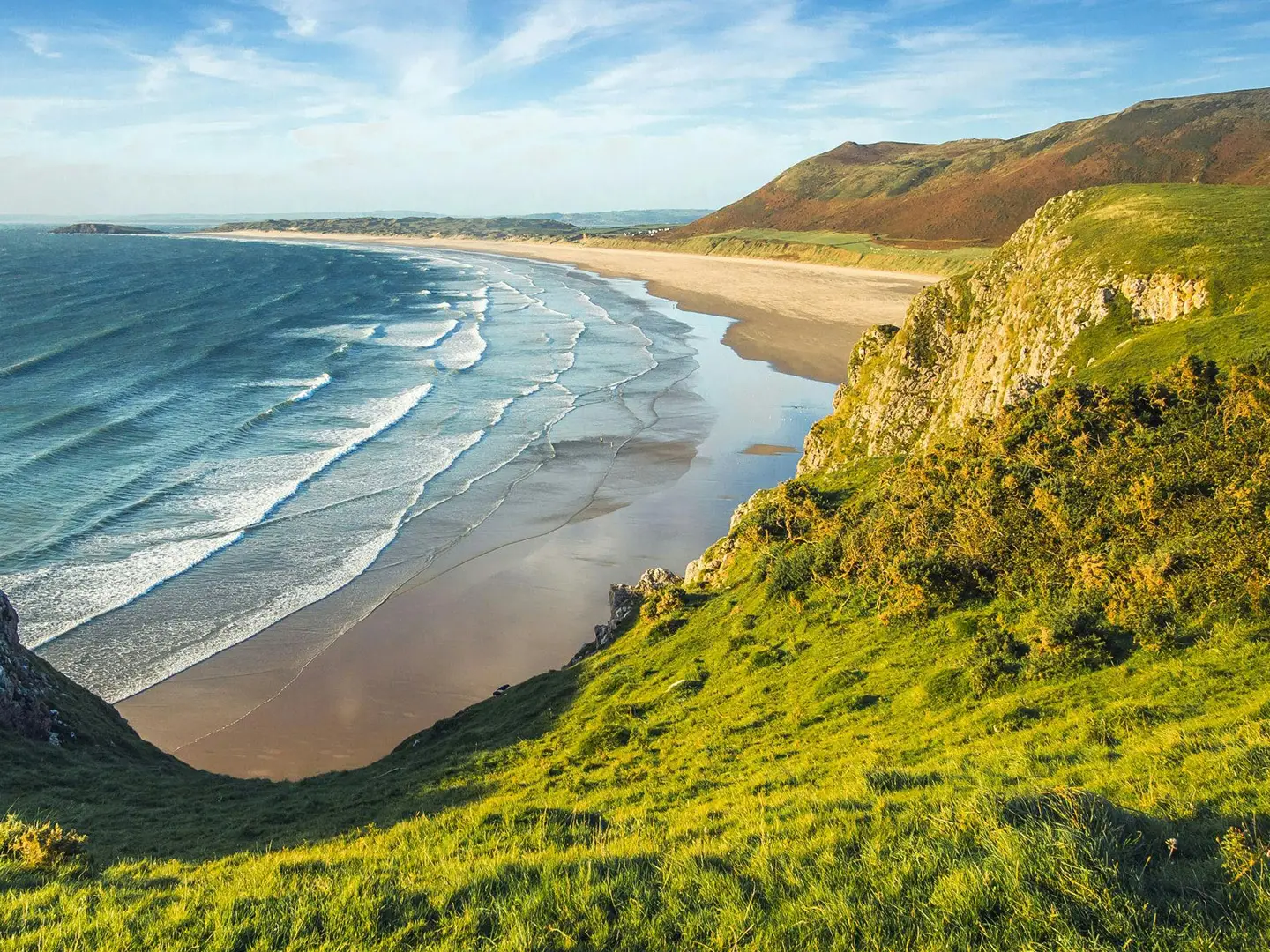
- Rhossili Bay & Worm’s Head, Gower: Rhossili Bay is a three-mile sweep of sand on the Gower Peninsula. Worm’s Head is a tidal headland reached on foot only around low tide.
- Harlech Castle: A 13th-century Edward I fortress above Tremadog Bay, included in the UNESCO-listed Castles and Town Walls of King Edward in Gwynedd.
Challenges to expect
The Wales Coast Path is not technically hard, but its scale is the main challenge: 1,400 km and about 27,000 m of ascent. Expect mixed surfaces including cliff paths, field paths, dunes, promenades, paved cycle routes and occasional boardwalk. Short steep ascents and descents occur, especially in Pembrokeshire and on the Llyn Peninsula. Weather can be wet and windy, and some inland diversions avoid estuaries and military ranges. For another coastal comparison, see the Ayrshire Coastal Path.
HikeList Score
Wales Coast Path scored 84/100 on HikeList's trail-quality metrics.
See score breakdownHide breakdown
- Ideal length 52
- Balanced challenge 100
- Scenery & wildness 98
- Varied terrain 65
- Accommodation 92
- Food & support 88
- Path quality 87
- Season flexibility 89
Computed from length, challenge, scenery & wildness, terrain variety, accommodation, food & support, path quality and season flexibility.
 United Kingdom
 Wales
WalesShow more data Show less
- Coastal
- Dirt
- Gravel
- Rocky
- Paved
- Boardwalk
- Hotels
- Hostels
- Campsites
- Wild Camping Spots
- Family Friendly
- Pet Friendly
- Restrooms
- Water Sources
- Campsites
- Picnic Areas
Download Our Full Guide to Wales Coast Path FREE!
Get our comprehensive guide to this hike for free. Save it for later reading or print out at home.

Photos from hikers
Taken on the trail by people who've reviewed Wales Coast Path.
Wales Coast Path: The Complete Guide
 i
Image by Pixabay
i
Image by Pixabay Llwybr Arfordir Cymru, the Wales Coast Path, is a 1,400 km waymarked journey around the entire Welsh coastline, linking Cas-gwent (Chepstow) on the Severn Estuary with Queensferry on the Dee Estuary. It is not a wilderness trail, but a long, varied coastal walk where towns, estuaries, cliffs, beaches and promenades all matter to the planning.
The route changes character constantly: South Wales towns and estuaries give way to Penrhyn Gŵyr (Gower), Carmarthenshire, the Pembrokeshire cliffs, Ceredigion, the Llŷn Peninsula, Ynys Môn (Anglesey) and the North Wales coast. Some days feel remote and exposed; others are straightforward, well-served and easy to break into short sections.
For most walkers, the path works best as a series of week-long sections rather than one continuous end-to-end. Strong public transport, frequent coastal settlements and established accommodation make that practical, especially on the North Wales coast, South Wales and the better-known holiday stretches.
A full thru-hike is a different commitment. The trail is generally well waymarked and non-technical, but 8–12 weeks of repeated climbs, wet and windy Atlantic weather, eroded or muddy paths, and occasional thin accommodation options demand proper planning.
This guide covers stages, daily planning, accommodation, food, transport, terrain and the common mistakes to avoid.
Stage-by-Stage Guide
The Wales Coast Path is usually planned by region rather than as eight literal walking days. The stages below follow the route’s eight broad planning blocks, using the south-to-north direction from Cas-gwent (Chepstow) to Queensferry. Exact daily splits should be built from current accommodation, transport and the official distance tables, especially on the remoter cliff sections.
Stage 1: Cas-gwent (Chepstow) to Caerdydd (Cardiff) — South Wales Coast & Severn Estuary, approx. 156 km
This opening stage leaves the Welsh–English border at Cas-gwent (Chepstow), near the old Wye bridge and below Chepstow Castle, then works around the Severn Estuary towards Casnewydd (Newport) and Caerdydd (Cardiff). It is a practical, varied start: estuary margins, low-lying coast, urban edges and sections where the route threads around developed or industrial land.
Underfoot, expect a mixture of surfaced paths, field edges, estuary-side tracks, promenades and tarmac. It is not technically difficult, but wet weather can make low-lying paths muddy or waterlogged, and the estuary landscape can feel exposed in wind. Some inland diversions are part of the character of this section where the direct coastline is interrupted.
The main places for resupply and services are Cas-gwent (Chepstow), Casnewydd (Newport) and Caerdydd (Cardiff). Food and water are generally easier to plan here than on the wilder western stages, but long urban-fringe or estuary stretches can still be inconvenient if shops are not close to the path. Carry enough for the day rather than relying on an unplanned café stop.
Accommodation is strongest at the start and finish, with the best choice in Caerdydd (Cardiff). Cas-gwent (Chepstow), Casnewydd (Newport) and Caerdydd (Cardiff) also make practical section-hiking bases because South Wales rail services serve all three. Current train times, engineering works and last services should be checked before travelling.
Navigation is generally straightforward because the route is waymarked with the Wales Coast Path dragon-shell signs, but urban and industrial edges need more attention than open clifftops. Watch for waymarks at junctions, around road crossings and where the coast path shares surfaced paths. Temporary diversions are more likely around developed areas and should be checked before travelling.
Stage 2: Caerdydd (Cardiff) to Abertawe (Swansea) / Penrhyn Gŵyr (Gower) — approx. 114 km
From Caerdydd (Cardiff), the path continues through the Vale of Glamorgan coast via Penarth, Y Barri (Barry), Llanilltud Fawr (Llantwit Major), Aberogwr (Ogmore-by-Sea), Porthcawl and Port Talbot before reaching Abertawe (Swansea) and the approach to Penrhyn Gŵyr (Gower). This stage has a broader coastal feel than the Severn Estuary, with towns, beaches, cliffs, resort sections and more open stretches.
Terrain varies frequently. Expect promenades and surfaced coast paths near towns, rougher field and headland paths on open coast, and possible muddy going after rain. Some sections pass built-up or industrial areas, especially around the larger South Wales settlements, so do not expect continuous wild coastline.
Key service points include Penarth, Y Barri (Barry), Llanilltud Fawr (Llantwit Major), Porthcawl, Port Talbot and Abertawe (Swansea). Food and water are usually manageable with planning, but there can be gaps between settlements on the more open coast. Start each day with enough water, particularly in warm weather or on exposed headland sections.
Abertawe (Swansea) is the strongest accommodation and transport hub at the end of the stage. There is also accommodation in the coastal towns and resorts along the way, with more choice in larger places. South Wales rail serves Caerdydd (Cardiff) and Abertawe (Swansea), making this one of the easier parts of the route to divide into short sections; local onward transport for smaller settlements should be checked before travelling.
Navigation is usually clear, but pay close attention where the path leaves promenades, crosses urban edges or diverts inland around obstacles. On open cliff and field sections, the waymarks are important because informal paths can branch towards beaches, car parks or headlands.
The main warnings here are exposure to wind and rain on open coast, muddy field paths after wet spells, and route-finding through developed areas. If making side trips to tidal features such as Worm’s Head (Pen Pyrod) later on Penrhyn Gŵyr (Gower), tide times must be checked carefully; that is not a casual all-state-of-tide walk.
Stage 3: Penrhyn Gŵyr (Gower) and Abertawe (Swansea) to Amroth — Carmarthenshire, approx. 109 km
This stage links the Gower and Swansea Bay area with the Carmarthenshire coast, passing Y Mwmbwls (Mumbles), Rhossili, Llanelli, Porth Tywyn (Burry Port), Cydweli (Kidwelly), Glanyferi (Ferryside), Llansteffan and Talacharn (Laugharne) before reaching Amroth at the Pembrokeshire border. It is a transition from the more dramatic Gower coast to estuary, marsh, dune and lowland coastal walking.
Penrhyn Gŵyr (Gower) gives some of the best-known scenery of the stage, including Rhossili Bay and views towards Worm’s Head (Pen Pyrod). East and north of the peninsula, the walking becomes more varied and often gentler, with surfaced coastal path, estuary-side sections, low-lying ground and towns. After rain, the softer lowland sections can be muddy or waterlogged.
Food and water are available in the larger settlements, including Abertawe (Swansea), Y Mwmbwls (Mumbles), Llanelli, Porth Tywyn (Burry Port), Cydweli (Kidwelly), Glanyferi (Ferryside), Llansteffan and Talacharn (Laugharne). Some smaller places may have limited opening hours, so do not plan a day around a single unconfirmed shop or pub. This should be checked before travelling.
Accommodation is generally available in and around the main towns and coastal villages, but the choice varies by season. Amroth is a useful end point because it marks the transition into the Pembrokeshire Coast Path section, but accommodation should be booked ahead if using it as a stage break. Campsites and B&Bs exist along popular coastal areas, but availability changes significantly between high season and quieter months.
Public transport is stronger around Abertawe (Swansea), Llanelli and the larger South Wales settlements than on the quieter Carmarthenshire coast. Local buses and rail links can help with section-hiking, but services to smaller coastal villages may be infrequent. Current timetables should be checked before committing to a linear day.
Navigation is normally not difficult, but estuary and lowland sections can involve less obvious coastline than cliff walking. Watch for waymarks where the path turns inland, follows surfaced shared-use routes or negotiates settlements. Be prepared for wind exposure on beaches and headlands, and for slippery mud after rain.
Stage 4: Amroth to Llandudoch (St Dogmaels) / Aberteifi (Cardigan) — Pembrokeshire Coast Path, approx. 299 km
This is the longest and most physically demanding stage in the guide, following the Pembrokeshire Coast Path through the UK’s only truly coastal national park. From Amroth it passes Dinbych-y-pysgod (Tenby), Penfro (Pembroke), Aberdaugleddau (Milford Haven), Aberllydan (Broad Haven), Tyddewi (St Davids), Abergwaun (Fishguard), Trefdraeth (Newport, Pembrokeshire) and on towards Llandudoch (St Dogmaels) and Aberteifi (Cardigan).
The walking is classic cliff-country coast path: repeated short, steep climbs and descents, narrow grassy paths, coves, headlands and exposed Atlantic viewpoints. There is no technical scrambling on the main route, but the constant up-and-down makes it far harder than the map distance may suggest. In wet weather, grass and mud can be slippery, and in high winds the exposed cliff sections deserve caution.
Major highlights include Dinbych-y-pysgod (Tenby), the coast around Tyddewi (St Davids) and St Davids Cathedral, the north Pembrokeshire cliffs, and the high ground of Cemaes Head / Pen yr afr, around 175 m on the Pembrokeshire section. The path also passes through a landscape of coves, sea stacks and seabird-rich cliffs. Views are often superb, but visibility and wind can change quickly.
Food and water planning is more important here than on the South Wales stages. The named towns and villages provide the main resupply options, but there are long, remote-feeling cliff sections between them and some seasonal businesses may not open every day. Carry a full day’s food and water whenever the next confirmed service is uncertain.
Accommodation is plentiful in the best-known Pembrokeshire resorts and towns, but can be thin on remote cliff sections and very busy in high season. Dinbych-y-pysgod (Tenby), Penfro (Pembroke), Aberdaugleddau (Milford Haven), Aberllydan (Broad Haven), Tyddewi (St Davids), Abergwaun (Fishguard), Trefdraeth (Newport, Pembrokeshire), Llandudoch (St Dogmaels) and Aberteifi (Cardigan) are the key planning points. Book ahead rather than assuming there will be a bed at the end of a hard day.
Public transport is useful but must be planned carefully. Pembrokeshire has dedicated coastal bus services, including the Puffin, Strumble and Poppit shuttle buses, which are valuable for section-hiking and for avoiding forced long days. Timetables and operating seasons should be checked before travelling.
Navigation is helped by both Wales Coast Path waymarks and National Trail acorn waymarks on this incorporated section. Even so, take particular care where field paths meet cliff paths, where erosion has altered the line, and where the route diverts inland. The Castlemartin military range can affect access in Pembrokeshire, so current access arrangements and any live route notices must be checked before relying on a planned line.
The key warnings are exposure, wind, slippery cliff paths after rain, cumulative fatigue from repeated climbs, and limited escape options on some headland sections. This is a place to carry proper waterproofs, warm layers, a map or reliable offline navigation, and enough food and water to finish the day independently.
Stage 5: Aberteifi (Cardigan) to Ynyslas / Dyfi Estuary — Ceredigion, approx. 116 km
North of Aberteifi (Cardigan), the path enters the Ceredigion coast, passing Ceinewydd (New Quay), Aberaeron and Aberystwyth before reaching Ynyslas and the Dyfi Estuary. This stage is shorter than Pembrokeshire but still has a remote coastal feel in places, especially where the route runs along quieter cliffs and headlands between towns.
The terrain includes cliff paths, field paths, beaches, dunes, estuary edges and occasional surfaced sections near settlements. Conditions can be muddy or slippery after rain, and open clifftops are exposed to Atlantic wind. Compared with Pembrokeshire, the stage is less continuously severe, but it should not be treated as a simple promenade walk.
Ceinewydd (New Quay) is one of the major highlights, set on Cardigan Bay, where resident bottlenose dolphins are regularly seen offshore in the wider bay. Aberaeron and Aberystwyth are important service and accommodation stops, while Aberteifi (Cardigan) is a strong southern base. The route also approaches the Dyfi Estuary at the northern end, where the coast path line and onward transport need careful planning.
Food and water are available in Aberteifi (Cardigan), Ceinewydd (New Quay), Aberaeron and Aberystwyth, but smaller intervening settlements should not be relied on without checking. North Ceredigion is one of the areas where accommodation and services can be thinner, so daily distances should be planned around confirmed overnight stops. Carry enough supplies for the full day on quieter stretches.
Aberystwyth is the main transport and accommodation hub on this stage and is served by the Cambrian Coast rail corridor. Away from Aberystwyth, local buses are likely to be more important for section-hiking. Current public transport times, especially for the northern end near Ynyslas and the Dyfi Estuary, should be checked before travelling.
Navigation is generally good on the waymarked path, but keep alert where the route crosses fields, leaves beaches or detours around estuary margins. Coastal erosion, mud and seasonal vegetation can make the walked line less obvious in places. The Dyfi Estuary area is a natural point to check the onward route carefully before continuing into Meirionnydd.
Stage 6: Aberdyfi (Aberdovey) to Caernarfon / Bangor — Menai, Llŷn & Meirionnydd, approx. 304 km
This long stage covers the Meirionnydd coast, the Llŷn Peninsula and the approach to the Menai Strait, passing Aberdyfi (Aberdovey), Tywyn, Abermaw (Barmouth), Harlech, Porthmadog, Aberdaron, Pwllheli and Caernarfon before reaching Caernarfon or Bangor depending on how the stage is split. It is one of the most varied and logistically important parts of the route.
Terrain changes repeatedly. Expect beaches, dunes, estuary and marsh sections, surfaced coastal paths, field paths and wilder headland walking, especially around Penrhyn Llŷn (the Llŷn Peninsula). The peninsula is more remote than the resort sections of North Wales and demands more careful food, water and accommodation planning.
Major highlights include Harlech Castle above Tremadog Bay, the coast around Porthmadog, the remote Welsh-speaking character of Penrhyn Llŷn, Aberdaron and the approach towards Caernarfon Castle on the Menai Strait. The route repeatedly returns to sea level, but short climbs and descents on headlands can still be tiring over consecutive days.
Food and water are available in the larger settlements such as Aberdyfi (Aberdovey), Tywyn, Abermaw (Barmouth), Harlech, Porthmadog, Aberdaron, Pwllheli, Caernarfon and Bangor. Between them, especially on Penrhyn Llŷn, services may be sparse and seasonal. Plan each day from one confirmed service point to the next and carry reserves.
Accommodation is generally available in the main coastal towns, with more choice in places such as Abermaw (Barmouth), Porthmadog, Pwllheli, Caernarfon and Bangor. Remoter parts of Penrhyn Llŷn can have thinner options, so booking ahead is strongly recommended. Campsites, B&Bs and small hotels may not all operate year-round.
Transport is good along parts of the Meirionnydd coast thanks to the Cambrian Coast line serving the Pwllheli–Porthmadog–Harlech–Barmouth–Aberystwyth corridor. This makes some sections easier to walk as linear day hikes. Penrhyn Llŷn and the approach to Caernarfon rely more on local buses and road access; current timetables should be checked before travelling.
Navigation is usually clear but needs attention at estuaries, beaches and where inland diversions avoid awkward coastline. On Penrhyn Llŷn, do not underestimate weather exposure or the distance between services. Wind, rain, mud and limited transport options can turn a planned easy day into a much more committing one.
Stage 7: Porthaethwy (Menai Bridge) to Bangor via Ynys Môn (Anglesey) — approx. 212 km
This stage forms the circuit of Ynys Môn (Anglesey), starting at Porthaethwy (Menai Bridge), passing Biwmares (Beaumaris), Moelfre, Amlwch, Caergybi (Holyhead) and Aberffraw, then returning to the mainland at Bangor. It incorporates the Anglesey Coastal Path and gives a distinct island stage within the wider Wales Coast Path.
The terrain includes clifftop paths, field and headland paths, beaches, dunes, estuary and marsh sections, and some surfaced coastal walking near settlements. Much of the island feels open and exposed, and the remoter sections can be slow in poor weather. Paths may be muddy or waterlogged after rain.
Key highlights include the Menai Strait, Biwmares (Beaumaris), the north and west coasts of Ynys Môn, Caergybi (Holyhead), and South Stack Lighthouse (Ynys Lawd) on Holy Island. South Stack is known for its cliffs and seabirds, with puffins, guillemots and razorbills associated with the RSPB cliffs. The views are often wide and sea-facing, but wind exposure is a major factor.
Food and water are available in the main settlements, including Porthaethwy (Menai Bridge), Biwmares (Beaumaris), Moelfre, Amlwch, Caergybi (Holyhead), Aberffraw and Bangor. Between these points, services can be limited, particularly on quieter coastal stretches. Carry enough water and food to complete each day without relying on a small seasonal outlet.
Accommodation is found in the larger towns and coastal villages, but parts of Ynys Môn are thinner for walkers than the North Wales resort strip. Caergybi (Holyhead) and Bangor are particularly useful transport and accommodation anchors. Booking ahead is advisable, especially in summer and on weekends.
Transport is strongest at Caergybi (Holyhead) and Bangor, both on the North Wales coast mainline rail corridor. Elsewhere on Ynys Môn, local buses and road access are the main options for section-hiking. Current bus times and the practicality of reaching minor trailheads should be checked before travelling.
Navigation is generally supported by waymarking, but the island has many field paths, headlands and small coastal settlements where careful attention is needed. Watch for turns inland around estuaries, marshy ground or private land. The main warnings are exposed wind, muddy fields, possible erosion on cliff paths and longer gaps between reliable services.
Stage 8: Bangor to Queensferry — North Wales Coast & Dee Estuary, approx. 109 km
The final stage follows the North Wales coast from Bangor to Queensferry near Chester, passing Conwy, Llandudno, Bae Colwyn (Colwyn Bay), Y Rhyl (Rhyl), Prestatyn and Y Fflint (Flint). Compared with Pembrokeshire, Penrhyn Llŷn and parts of Ynys Môn, this is generally more accessible and transport-friendly, with promenades, resorts and estuary-side walking.
Terrain includes surfaced promenades, coastal cycle paths, beaches, lowland coastal paths, estuary margins and some headland walking. The standout high ground is Y Gogarth (Great Orme) at Llandudno, a limestone headland above the resort. Most of the stage is not technically hard, but long surfaced sections can be tiring on feet, and wind can still be strong along the open coast.
Key highlights include Conwy and Conwy Castle, the walled town and estuary setting at Conwy, Y Gogarth (Great Orme), Llandudno, and the long resort coast through Bae Colwyn (Colwyn Bay), Y Rhyl (Rhyl) and Prestatyn. The route then continues towards the Dee Estuary and Queensferry, where it adjoins Offa’s Dyke Path near the Welsh–English border.
Food and water availability is generally good by Wales Coast Path standards. Bangor, Conwy, Llandudno, Bae Colwyn (Colwyn Bay), Y Rhyl (Rhyl), Prestatyn and Y Fflint (Flint) all provide useful service points. Even so, carry water between towns, especially on warm days or if walking long promenade sections where detours to shops can add time.
Accommodation is widely available along the North Wales coast, particularly in the resort towns and larger settlements. This is one of the easier stages to split into short walking days because there are many towns close to the path. Queensferry itself is the northern terminus area; onward accommodation and transport may also be planned around nearby Chester, but details should be checked before travelling.
Public transport is one of the strengths of this stage. The North Wales coast mainline railway serves Bangor, Conwy via nearby rail access, Llandudno Junction, Llandudno, Bae Colwyn (Colwyn Bay), Y Rhyl (Rhyl), Prestatyn, Y Fflint (Flint) and the wider Chester–Holyhead corridor. This makes linear day walks and bail-out options much easier than on remoter western stages.
Navigation is mostly straightforward on promenades and well-used coastal paths, but take care where the route threads estuaries, road crossings, resort edges and the approach to Queensferry. Do not switch off entirely because urban coast sections can have many paths, cycleways and road junctions. The main practical warnings are hard surfaces, wind exposure, occasional mud on lowland sections, and the need to check live diversions before the final approach to the border.
Recommended Itinerary
The Wales Coast Path is too long for a single fixed town-to-town itinerary to suit every walker. Accommodation availability, seasonal buses, diversions, weather and personal pace all affect daily stopping points, so the most reliable way to plan it is by the official eight regions, then break each region into bookable daily stages using the official distance tables and interactive map.
The table below is a practical standard end-to-end framework. Treat each row as a multi-day walking block, not a single walking day.
Standard itinerary: eight regional blocks
| Day | From | To | Approx. distance | Why this stage makes sense | Services/accommodation notes |
|---|---|---|---|---|---|
| 1 | Cas-gwent (Chepstow) — South Wales Coast & Severn Estuary | Caerdydd (Cardiff) | 156 km / 97 mi | A logical opening block from the southern terminus, with the route passing through or near Casnewydd (Newport) before reaching the capital. It is one of the easier regions to break into shorter stages because transport and settlements are comparatively frequent. | Strong rail access at Cas-gwent (Chepstow), Casnewydd (Newport) and Caerdydd (Cardiff). Accommodation is generally easier to arrange than on the remoter western and northern peninsulas, but book ahead for weekends and city stays. |
| 2 | Caerdydd (Cardiff) | Abertawe (Swansea) / Penrhyn Gŵyr (Gower) | 114 km / 71 mi | This block links the urban South Wales coast with Swansea Bay and the start of the Gower walking. It works well as a transition from rail-served towns to more exposed headland and beach sections. | Good transport options at Caerdydd (Cardiff) and Abertawe (Swansea). Accommodation is usually plentiful around Swansea Bay and popular Gower bases, though summer demand can be high. |
| 3 | Penrhyn Gŵyr (Gower) / Swansea Bay | Amroth, at the Pembrokeshire border | 109 km / 68 mi | This is a compact block through Carmarthenshire, linking Gower and Swansea Bay with the start of Pembrokeshire. It is a sensible place to separate the South Wales sections from the more committing Pembrokeshire Coast Path. | Coastal towns and villages include Llanelli, Porth Tywyn (Burry Port), Cydweli (Kidwelly), Glanyferi (Ferryside), Llansteffan and Talacharn (Laugharne). Check exact daily distances and accommodation before booking, especially where the route rounds estuaries. |
| 4 | Amroth | St Dogmaels / Aberteifi (Cardigan) | 299 km / 186 mi | This is the major Pembrokeshire block and one of the hardest parts of the whole trail to rush. The walking is not technical, but repeated cliff climbs, exposed headlands and weather make conservative daily stages sensible. | Key service points include Dinbych-y-pysgod (Tenby), Penfro (Pembroke), Aberdaugleddau (Milford Haven), Aberllydan (Broad Haven), Tyddewi (St Davids), Abergwaun (Fishguard), Trefdraeth (Newport, Pembrokeshire) and Aberteifi (Cardigan). Pembrokeshire coastal buses, including services branded Puffin, Strumble and Poppit, are useful for section logistics; timetables should be checked before travelling. Accommodation can be thin between popular bases, so book remote nights early. |
| 5 | Aberteifi (Cardigan) | Ynyslas / Dyfi Estuary | 116 km / 72 mi | A manageable Ceredigion block, with Cardigan Bay walking, harbour towns and some quieter northern stretches. It is short enough to fit a week for many section-hikers, but still needs careful stage planning in poor weather. | Main places include Ceinewydd (New Quay), Aberaeron and Aberystwyth. North Ceredigion has thinner services than the bigger resort towns, so avoid assuming every map settlement has accommodation. Use official mapping before fixing overnight stops. |
| 6 | Aberdyfi (Aberdovey) | Caernarfon / Bangor | 304 km / 189 mi | This is the longest planning block and should usually be split into smaller sub-sections. It covers the Meirionnydd coast, the Llŷn Peninsula and the Menai coast, mixing rail-served stretches with remote, slower cliff and headland walking. | The Cambrian Coast line serves places on the Meirionnydd coast, including Aberdyfi, Tywyn, Abermaw (Barmouth), Harlech, Porthmadog and Pwllheli. The Llŷn Peninsula, including Aberdaron, is more remote and should be booked carefully. Bangor gives a strong transport break before or after the Anglesey circuit. |
| 7 | Porthaethwy (Menai Bridge) | Bangor, after circuiting Ynys Môn (Anglesey) | 212 km / 132 mi | A self-contained island circuit incorporating the Anglesey Coastal Path. It is long enough to deserve its own block, with exposed coastal walking and some quieter stretches away from the main towns. | Useful places include Porthaethwy (Menai Bridge), Biwmares (Beaumaris), Moelfre, Amlwch, Caergybi (Holyhead), Aberffraw and Bangor. Rail access at Bangor and Caergybi (Holyhead) helps section planning. Accommodation is thinner on parts of Ynys Môn than in the North Wales resorts, so do not leave remote nights to chance. |
| 8 | Bangor | Queensferry, near Chester | 109 km / 68 mi | A strong final block along the North Wales Coast and Dee Estuary, with easier logistics than many earlier sections. The walking includes promenades, estuary sections and headlands such as Y Gogarth (Great Orme) near Llandudno. | This is one of the best-served parts of the whole route. The Chester–Holyhead mainline has stations at Bangor, Conwy, Llandudno Junction, Colwyn Bay, Rhyl, Prestatyn and Y Fflint (Flint), making day-walking and bail-out options straightforward. Queensferry is the northern terminus near the English border. |
Slower itinerary
A slower end-to-end schedule suits walkers carrying camping kit, anyone wanting rest days, and anyone who prefers shorter days on the exposed cliff sections. Most end-to-enders should think in terms of roughly 69–84 walking days plus rest days, rather than trying to force the path into a tight schedule.
Use the same eight regional blocks, but split the longest and roughest areas more generously:
- Pembrokeshire: allow extra time for the repeated ascents and descents, especially between the more remote accommodation points.
- Menai, Llŷn & Meirionnydd: treat this as more than one block if walking the full 304 km section continuously.
- Ynys Môn (Anglesey): keep daily stages conservative where services are thinner.
- Rest days: sensible places for rest or resupply include larger towns and transport hubs such as Caerdydd (Cardiff), Abertawe (Swansea), Aberystwyth, Bangor and Caergybi (Holyhead).
Exact overnight stops should be set only after checking the official Wales Coast Path distance tables, current diversions and available accommodation.
Faster itinerary
A faster end-to-end schedule is realistic only for fit, experienced long-distance walkers who are comfortable averaging around 20 miles / 32 km per day for weeks. That brings the route into the 6–7 week range, but it leaves little spare capacity for storms, transport gaps, injury or fully booked accommodation.
A fast walker can still use the eight-region structure above, but should be particularly cautious about compressing:
- Pembrokeshire, where the cliff walking is slower than the map distance can suggest.
- The Llŷn Peninsula, where remoter stretches and fewer services can make long days harder to support.
- Ynys Môn (Anglesey), where accommodation spacing may dictate stage length more than fitness.
On a fast schedule, every overnight stop, food resupply and exit option should be planned before arrival in the remoter regions. Current trail notices, diversions, military-range access in Pembrokeshire and tide-dependent side trips such as Worm’s Head should be checked before travelling.
Planning the Route
Choose a realistic timescale
A full end-to-end walk of Llwybr Arfordir Cymru is best planned as a long expedition, not as a compressed coastal holiday. Very fit walkers can complete it in around 6–7 weeks at roughly 20 miles per day, but most end-to-enders should allow 8–12 weeks, or roughly 69–84 walking days plus rest and weather days.
The path rewards a slower schedule. Repeated short climbs on cliff sections, exposed Atlantic weather, accommodation spacing and public transport connections all make rigid high-mileage days harder than the map distance can suggest.
For most walkers, the better approach is to divide the route into its eight established regions and walk one region at a time. Each region can usually be treated as about a week of walking, though Pembrokeshire, Penrhyn Llŷn and Meirionnydd, and Ynys Môn (Anglesey) need longer if walked at a comfortable pace.
Plan by regions, then by overnight stops
Daily stages are not dictated by huts or official camps; they are dictated by towns, villages, bus stops, railway stations and available accommodation. On the busier resort and urban sections there is plenty of flexibility, while remoter cliff sections need more deliberate booking.
The official regional split is the most practical first layer of planning:
| Planning block | Approx distance | Practical planning notes |
|---|---|---|
| South Wales Coast & Severn Estuary: Cas-gwent (Chepstow) to Caerdydd (Cardiff) | 156 km | Strong rail access at Cas-gwent, Casnewydd (Newport), Caerdydd and other South Wales centres makes this one of the easier sections to split. |
| Gower & Swansea Bay: Caerdydd to Abertawe (Swansea) / Penrhyn Gŵyr (Gower) | 114 km | Mixes urban coast, resort infrastructure and more exposed Gower walking. Accommodation is generally easier around Abertawe, Y Mwmbwls (Mumbles) and popular Gower locations. |
| Carmarthenshire: Penrhyn Gŵyr / Llanelli to Amroth | 109 km | Plan around estuary and coastal settlements such as Llanelli, Porth Tywyn (Burry Port), Cydweli (Kidwelly), Glanyferi (Ferryside), Llansteffan and Talacharn (Laugharne). |
| Pembrokeshire Coast Path: Amroth to St Dogmaels / Aberteifi (Cardigan) | 299 km | A major undertaking in its own right, with the steepest-feeling repeated cliff walking. Accommodation and coastal bus links are good in many places but thin on some north Pembrokeshire stretches, so book ahead. |
| Ceredigion: Aberteifi (Cardigan) to Ynyslas / Dyfi Estuary | 116 km | Plan carefully through the quieter northern part of the county. Ceinewydd (New Quay), Aberaeron and Aberystwyth are useful service points. |
| Menai, Llŷn & Meirionnydd: Aberdyfi to Caernarfon / Bangor | 304 km | One of the longest planning blocks, combining the Meirionnydd coast, Penrhyn Llŷn and the Menai coast. The Cambrian Coast railway helps on parts of the Meirionnydd coast, but Penrhyn Llŷn is more remote. |
| Ynys Môn (Anglesey): Porthaethwy (Menai Bridge) to Bangor | 212 km | The island circuit has exposed headlands and thinner services in places. Accommodation should be planned ahead away from the main towns. |
| North Wales Coast & Dee Estuary: Bangor to Queensferry | 109 km | The easiest region to split by train, with the North Wales coast mainline serving places including Bangor, Conwy, Llandudno Junction, Colwyn Bay, Rhyl, Prestatyn and Y Fflint (Flint). |
Per-region distances vary slightly between Wales Coast Path distance tables and other official visitor information, but both total about 870 miles / 1,400 km. For booking daily stages, use the current official point-to-point distance tables rather than relying only on headline regional totals.
Direction and pacing
The route can be walked in either direction. The official and most commonly described direction is south to north, from Cas-gwent (Chepstow) to Queensferry, but many walkers go north to south without any practical disadvantage.
South-to-north planning gives a clear progression through South Wales, Gower, Carmarthenshire, Pembrokeshire, Ceredigion, Meirionnydd and Penrhyn Llŷn, Ynys Môn, then the North Wales coast. North-to-south planning can work well for walkers using Chester and the North Wales rail corridor as an access point.
Avoid building the whole itinerary around identical daily mileage. A 20-mile day on a promenade or surfaced coastal path is very different from a 20-mile day of cliff-top ascents, mud, wind and remote headlands.
Section hiking is often the best strategy
Llwybr Arfordir Cymru is exceptionally well suited to section hiking. Rail access on the South Wales coast, the Cambrian Coast line, and the North Wales coast mainline makes it possible to walk many sections as day walks, long weekends or one-week blocks.
Transport is strongest around South Wales, the Cambrian Coast and the North Wales coast. Remoter parts of Pembrokeshire, Ceredigion, Penrhyn Llŷn and Ynys Môn rely more on local buses and dedicated coastal services, including Pembrokeshire coastal shuttle buses such as the Puffin, Strumble and Poppit services.
For section walkers, the key is to plan each day as a transport problem as much as a walking problem. Check the last bus or train before committing to a linear day, especially on Sundays, public holidays and outside the main visitor season.
Accommodation planning
Accommodation ranges from hotels, guesthouses and B&Bs to hostels and campsites. It is plentiful in many coastal towns and resorts, including the better-served South Wales, North Wales, Gower and Pembrokeshire stretches, but not evenly distributed along the whole coast.
Book ahead on remoter cliff sections, especially parts of Ynys Môn, Penrhyn Llŷn, north Ceredigion and north Pembrokeshire. In these areas the practical overnight stop may decide the day length more than fitness does.
End-to-enders should also build in rest nights at larger service towns. These are useful for laundry, food resupply, drying kit, replacing worn footwear and absorbing weather delays.
Wild camping is used by some long-distance walkers where practical, but there is no formal right to wild camp in Wales. Anyone planning to camp should use established campsites where available and check local arrangements before relying on informal camping.
Food, water and resupply
Food planning is straightforward through towns and resorts, but not every coastal day passes a shop or reliable café at the right time. Carry lunch, snacks and enough water for the full day whenever the route leaves a main settlement for cliffs, headlands, dunes or estuary margins.
Opening hours can be limited in smaller villages and outside peak season. Do not assume that a café, pub or shop marked on a map will be open when needed; this should be checked before travelling.
The longer remote sections are not wilderness, but they do punish casual planning. Start each day knowing where the next realistic food stop is and where the overnight accommodation is located relative to the path.
Navigation and route changes
The path is waymarked with the yellow, blue and white dragon shell, and the Pembrokeshire section also carries National Trail acorn waymarks. Waymarking is generally good, but a map or reliable navigation app remains essential.
Navigation is most likely to need attention around estuaries, urban edges, industrial areas, beaches, dunes, farmland and places where erosion or land management causes diversions. Some inland diversions are part of the normal route, including those avoiding estuaries, military ranges such as Castlemartin, and industrial areas.
Before each section, check the official interactive map and current trail notices for closures, diversions and access restrictions. This is especially important where a day depends on a bus connection, a long cliff section, a military-range crossing or any tide-dependent side trip such as Worm’s Head on Gower.
Weather and safety planning
Weather is one of the main route-planning variables. The coast is exposed to wet, windy Atlantic conditions, and cliff sections can feel much harder in strong wind or poor visibility.
Spring, summer and autumn are the main walking seasons. Even then, waterproofs, warm layers and secure footwear are needed, and paths can be muddy, eroded or waterlogged after rain.
Build slack into any end-to-end itinerary. A spare day can prevent a missed booking, a dangerous push over exposed ground, or a forced walk through weather that would be sensible to sit out.
Permits and access issues
There is no general permit system for walking the Wales Coast Path itself. The more important planning issue is local access: temporary diversions, military-range access, weather damage, and occasional route changes.
Castlemartin in Pembrokeshire is the key named military-range area on the route. Current access arrangements should be checked before travelling, and alternative timing may be needed if a planned section is affected.
Towns, Villages and Overnight Stops
The Wales Coast Path is unusually service-rich for a long-distance trail, but the gaps are uneven. Larger towns and resorts make straightforward overnight bases; smaller villages on the remoter cliff sections can have limited accommodation, limited evening food and seasonal opening, so booking ahead matters.
For section-hiking, the most useful overnight stops are usually those with rail links or reliable local buses. On Anglesey, the Llŷn, Ceredigion and Pembrokeshire, do not assume a late bus, an evening meal or a same-day bed will be available without checking.
Cas-gwent (Chepstow)
Cas-gwent is the southern terminus on the Severn Estuary, at the Welsh–English border near the old Wye bridge and below Chepstow Castle. It is a logical first or last overnight stop, especially for walkers needing to start early or finish without a long onward journey.
Accommodation and food options are stronger here than on the more rural stretches that follow. Cas-gwent also has rail links, making it one of the easier places to reach by public transport.
Casnewydd (Newport)
Casnewydd is one of the first major urban service points after the Severn Estuary section. It works well as a practical overnight stop for walkers splitting the South Wales Coast and Severn Estuary region into manageable stages.
There is frequent rail at Casnewydd, so it is also useful for joining, leaving or shortening this part of the route. Food and accommodation planning is generally easier here than in smaller coastal settlements.
Caerdydd (Cardiff)
Caerdydd is the major city stop on the South Wales coast and one of the easiest places on the whole route for accommodation, food and onward transport. It is a natural break point between the Chepstow–Cardiff stretch and the onward route towards the Vale of Glamorgan and Swansea Bay.
Frequent rail services make Caerdydd especially useful for section-hikers. It is also a sensible rest-day location for end-to-enders who need laundry, replacement kit or a wider choice of places to stay.
Penarth
Penarth sits just beyond Caerdydd on the coast and can be used as a quieter alternative overnight stop if the day’s mileage works better than staying in the city. It is close enough to the Cardiff area to be useful for logistics, but exact transport and accommodation options should be checked before booking a stage around it.
For walkers continuing west, Penarth marks the transition from the urban South Wales coast towards the resort and cliff sections of the Vale of Glamorgan. Check food availability if arriving late.
Y Barri (Barry)
Y Barri is a practical coastal stop between Penarth and the western Vale of Glamorgan. It is better suited to overnighting than the smaller places either side because it is a sizeable town on the route.
Use it for accommodation, meals and resupply before continuing towards Llanilltud Fawr and Ogmore-by-Sea. Public transport details and current service frequency should be checked before relying on it for a point-to-point day.
Llanilltud Fawr (Llantwit Major)
Llanilltud Fawr is a useful stop on the Vale of Glamorgan section, particularly for walkers not wanting to push directly between the larger South Wales towns. It can work as an overnight base, but accommodation should be arranged ahead in busy periods.
Food options and opening hours should be checked if arriving late. This is a good place to reassess timing before the route continues west towards Ogmore-by-Sea and Porthcawl.
Aberogwr (Ogmore-by-Sea)
Aberogwr is a smaller coastal stop before Porthcawl. It can suit walkers looking to break up the coast into shorter days, but it should not be treated like a major service town.
Book accommodation and evening food ahead if planning to stop here. If services are limited, Porthcawl is the more robust overnight target.
Porthcawl
Porthcawl is one of the more useful resort stops on the South Wales coast. It is a good overnight option before or after the more developed and industrial stretches around Port Talbot.
Accommodation and food planning is usually easier in a resort town than in smaller villages, though seasonal demand can still matter. It is also a sensible place to pause if weather makes exposed coastal walking unattractive.
Port Talbot
Port Talbot is a practical service stop on the approach to Swansea Bay. The route in this wider area includes more urban and industrial-influenced walking, so the value of stopping here is mainly logistical rather than scenic.
It can be useful for accommodation, food and transport connections, but exact rail or bus options for a planned stage should be checked before travelling. Walkers continuing west should plan the next day around the Swansea Bay section.
Abertawe (Swansea)
Abertawe is one of the key logistics hubs of the entire Wales Coast Path. It has frequent rail, a wide choice of services and makes a natural overnight or rest stop before the route moves into Y Mwmbwls and Penrhyn Gŵyr (Gower).
For end-to-enders, Abertawe is a strong place for laundry, kit replacement, food shopping and resetting the itinerary. For section-hikers, it is one of the easiest places to access the path by public transport.
Y Mwmbwls (Mumbles)
Y Mwmbwls sits at the western end of Swansea Bay and is a practical gateway to the Gower section. It is a good overnight stop if you want to leave the city behind before tackling the more coastal walking beyond.
Accommodation and eating options are generally more favourable here than in the smaller settlements further round Gower. Book ahead in popular walking seasons and at weekends.
Rhossili
Rhossili is a key stop on Penrhyn Gŵyr (Gower), close to Rhossili Bay and Worm’s Head. It is a worthwhile overnight target if the itinerary allows, but it is more exposed and less urban than Swansea or Y Mwmbwls.
Accommodation should be booked ahead, particularly in holiday periods. Worm’s Head is tide-dependent, so any side trip or timing around the headland must be checked before travelling.
Llanelli
Llanelli is the main service town as the route enters the Carmarthenshire coast from the Gower and Loughor area. It is a practical overnight base and a useful resupply point before continuing towards Burry Port and Kidwelly.
The Carmarthenshire section has more estuary and coastal path walking than exposed cliff walking, but stage logistics still need care. Check public transport times before setting a one-way day from here.
Porth Tywyn (Burry Port)
Porth Tywyn is a useful smaller stop west of Llanelli. It can work well for an overnight if the day’s distance fits, especially for walkers breaking the Carmarthenshire section into shorter stages.
Accommodation and food availability should be checked ahead rather than assumed. It is a good staging point before continuing towards Cydweli and Glanyferi.
Cydweli (Kidwelly)
Cydweli is another practical Carmarthenshire stop and can be used to avoid overlong stages between Llanelli, Burry Port and the Taf estuary area. It is likely to be more limited than the larger towns, so book accommodation and meals in advance.
This is a useful place to review onward logistics, because the route through Carmarthenshire includes several smaller settlements before Pembrokeshire begins. Public transport details should be checked before travelling.
Glanyferi (Ferryside)
Glanyferi is a small coastal stop on the Carmarthenshire section. It can make sense for a night if the route timing suits, but it should be planned carefully rather than treated as a guaranteed service hub.
Check accommodation, evening meals and any transport connection before committing to the stage. If services do not line up, adjust the day towards a larger neighbouring stop.
Llansteffan
Llansteffan is a smaller stop on the Carmarthenshire coast and is best treated as a planned overnight rather than a fallback. It may be useful for walkers wanting shorter days through this section.
Book ahead and check food availability, especially outside the main season. The next usable overnight may depend on how the route and local transport fit together that week.
Talacharn (Laugharne)
Talacharn is a worthwhile stop before the route continues towards Amroth and Pembrokeshire. It can be used as an overnight base, but accommodation and food should be arranged ahead in busy periods.
For end-to-enders, this is a useful point to prepare for the more committing Pembrokeshire Coast Path section. Check onward transport carefully if using Talacharn as the start or finish of a section walk.
Amroth
Amroth marks the start of the Pembrokeshire Coast Path section for northbound walkers. It is an important staging point because Pembrokeshire is one of the most demanding and scenic parts of the whole route, with repeated short climbs and exposed cliff walking.
Accommodation can be in demand, so book ahead. This is a sensible place to make sure the next few nights are fixed, as some north Pembrokeshire stretches have thinner services.
Dinbych-y-pysgod (Tenby)
Dinbych-y-pysgod is one of the strongest overnight bases in south Pembrokeshire. As a major coastal resort on the route, it is a good place for accommodation, meals, resupply and a rest or shorter day.
It is also a practical section-hiking base for the early Pembrokeshire Coast Path. Book well ahead in holiday periods, when coastal accommodation can fill quickly.
Penfro (Pembroke)
Penfro is a useful inland-and-estuary-side service point on the Pembrokeshire section. It works as an overnight stop and a practical place to manage logistics before continuing around the more remote parts of the county.
The wider Pembrokeshire route includes inland diversions around estuaries and the Castlemartin military range area. Any live access notices or diversions should be checked before travelling.
Aberdaugleddau (Milford Haven)
Aberdaugleddau is a significant Pembrokeshire service stop and a practical place to stay on the Milford Haven waterway section. It is useful for resupply and for breaking up the route before the path continues towards the west and north Pembrokeshire coast.
This is a good point to check coastal bus options and onward accommodation. Pembrokeshire has dedicated coastal shuttle services, but timetables and seasonal operation should be checked before relying on them.
Aberllydan (Broad Haven)
Aberllydan is a smaller coastal stop on the Pembrokeshire section. It is useful for walkers spacing out the exposed west-coast stages, but it should be booked rather than left to chance.
Food and accommodation can be more seasonal in small coastal places. It is a sensible overnight before or after the approach to Tyddewi, depending on daily mileage.
Tyddewi (St Davids)
Tyddewi is one of the key overnight stops in Pembrokeshire and one of the most useful bases on the north-west part of the route. Britain’s smallest city, it also gives access to St Davids Cathedral, but for walkers its main value is as a service and rest point on a demanding coastal section.
Accommodation demand can be high, so book ahead. Use Tyddewi to resupply, check weather, and confirm onward transport or coastal shuttle details before continuing towards Abergwaun.
Abergwaun (Fishguard)
Abergwaun is a major north Pembrokeshire stop and a strong place for an overnight. It is particularly useful because the coast around north Pembrokeshire can feel remote, with fewer easy fallbacks than the resort sections further south.
Plan accommodation, food and the next day’s transport before leaving. Pembrokeshire’s coastal shuttle buses can be useful in this region, but current timetables should be checked before travelling.
Trefdraeth (Newport, Pembrokeshire)
Trefdraeth is a smaller but important overnight stop near the northern end of Pembrokeshire. It helps break up the route between Abergwaun and Aberteifi, where services can be thinner and the cliff walking remains strenuous.
Book accommodation and evening meals in advance. Take care not to confuse this Trefdraeth with Casnewydd (Newport) in South Wales when booking or searching transport.
Aberteifi (Cardigan)
Aberteifi sits at the transition between Pembrokeshire and Ceredigion, with the regional boundary close to St Dogmaels/Cardigan. It is a key overnight and resupply point before the Ceredigion coast begins in earnest.
This is one of the better places to reorganise after the long Pembrokeshire section. Public transport and onward accommodation should still be checked, particularly for walkers heading into the more limited sections of north Ceredigion.
Ceinewydd (New Quay)
Ceinewydd is an important Ceredigion harbour town and is often cited as the marked halfway point of Llwybr Arfordir Cymru. It makes a good overnight stop, especially for walkers who want a psychological midpoint break.
Accommodation should be booked ahead in the main season. The wider Cardigan Bay area is known for resident bottlenose dolphins, but walkers should plan the stop around practical needs first: bed, food and the next day’s transport.
Aberaeron
Aberaeron is a useful Ceredigion stop between Ceinewydd and Aberystwyth. It can work well as an overnight where the day’s mileage suits, and is a sensible place to check food and accommodation before the route continues north.
Ceredigion has some thinner service stretches, especially away from the larger towns. Confirm evening food and any onward bus options before committing to a stage ending here.
Aberystwyth
Aberystwyth is the main logistics hub on the Ceredigion coast and a natural overnight or rest stop. It sits on the Cambrian Coast rail corridor, making it one of the more useful places for section-hikers in mid-Wales.
For end-to-enders, Aberystwyth is a good place to resupply and reset before the route heads towards the Dyfi Estuary and Meirionnydd. Accommodation is still worth booking ahead in busy periods.
Aberdyfi (Aberdovey)
Aberdyfi sits near the Dyfi Estuary at the start of the Menai, Llŷn and Meirionnydd region for northbound walkers. It is a useful overnight stop after Ceredigion and before the long mid-Wales and Llŷn section.
The Cambrian Coast line serves this wider Meirionnydd/mid-Wales coast corridor, but exact station arrangements and timetables should be checked before travelling. Book accommodation ahead if planning a precise stage end here.
Tywyn
Tywyn is a practical stop on the Meirionnydd coast north of Aberdyfi. It can be used to shorten the distance before Abermaw or to create a more manageable section-hiking day.
Accommodation, food and transport details should be checked before relying on Tywyn as an endpoint. The Cambrian Coast line is the key rail corridor through this part of Wales.
Abermaw (Barmouth)
Abermaw is one of the more useful overnight bases on the Meirionnydd coast. It sits on the Cambrian Coast line corridor and makes a practical stop before or after the route continues towards Harlech and Porthmadog.
As a coastal resort, it is a good place to look for accommodation and food, but summer demand can be high. Book ahead and check train times if using it for a section walk.
Harlech
Harlech is a strong route stop on the Meirionnydd coast, with the path passing below the castle above Tremadog Bay. It is useful for an overnight between Abermaw and Porthmadog.
The Cambrian Coast line serves Harlech, making it practical for section-hikers. Accommodation and evening food should still be checked, especially outside the main holiday season.
Porthmadog
Porthmadog is a key logistics point between the Meirionnydd coast and the Llŷn Peninsula. It sits on the Cambrian Coast line and is one of the more practical places to pause, resupply and organise the next remote stretch.
For northbound walkers, this is a sensible place to confirm accommodation around the Llŷn, where options can be thinner. Do not leave the next several nights unplanned if walking in peak season.
Aberdaron
Aberdaron is a key stop near the end of the Llŷn Peninsula, a more remote and Welsh-speaking part of the route. It is a valuable overnight base because the surrounding stages can be exposed and less service-rich.
Accommodation and meals should be booked ahead. Local transport on the Llŷn is more limited than in the rail-served coastal towns, so check bus options before building a section around Aberdaron.
Pwllheli
Pwllheli is one of the main service towns on the Llŷn and is on the Cambrian Coast line. It is a strong overnight and resupply point after the more remote western peninsula or before heading towards Caernarfon.
For section-hikers, Pwllheli is one of the most useful public transport access points in this region. Accommodation should still be reserved in busy holiday periods.
Caernarfon
Caernarfon is a major stop on the Menai coast, with the route passing the castle on the waterfront. It is one of the best places to pause before the path continues towards the Menai Strait and Ynys Môn (Anglesey) connections.
Use Caernarfon for accommodation, food and resupply before the island section or after completing the Llŷn and Meirionnydd stretch. Public transport details should be checked before planning a one-way day from here.
Porthaethwy (Menai Bridge)
Porthaethwy is a key transition point between the mainland and Ynys Môn. It is a useful overnight stop if you want to begin the Anglesey circuit with a fresh day rather than adding it to a long mainland stage.
Accommodation should be booked ahead, as the Anglesey section has thinner services in places. Check local buses before relying on public transport around the island.
Biwmares (Beaumaris)
Biwmares is an early Anglesey stop when walking the island circuit from Porthaethwy. It can work well as an overnight, particularly for walkers breaking Anglesey into shorter coastal days.
The island has a mix of towns, villages and quieter stretches, so plan each night rather than assuming frequent accommodation. Food and transport options should be checked before travelling.
Moelfre
Moelfre is a smaller Anglesey coastal stop and can be useful for spacing stages on the east and north-east side of the island. It is best treated as a booked overnight rather than a backup option.
Check accommodation, evening food and bus connections ahead. This applies especially outside the main walking and holiday seasons.
Amlwch
Amlwch is a practical service stop on the north Anglesey coast. It can be used to break the longer island circuit before the route heads towards Caergybi and Holy Island.
Accommodation and food should be checked in advance. Local buses are the main public transport option for much of Anglesey away from the Holyhead rail connection.
Caergybi (Holyhead)
Caergybi is the strongest logistics base on Anglesey and one of the key transport points on the whole route. It is on the Chester–Holyhead mainline railway, making it highly useful for section-hikers and for end-to-enders needing a reset.
It is a practical overnight before or after the South Stack and Holy Island area. Book accommodation ahead in busy periods and check onward island bus times if continuing round the coast.
Aberffraw
Aberffraw is a smaller stop on the south-west side of Anglesey. It may suit walkers dividing the island into shorter stages, but services are more limited than at Caergybi or Bangor.
Accommodation, meals and transport should be checked before committing to an overnight here. Build in flexibility if walking outside the main season.
Bangor
Bangor is a major mainland logistics hub and a key point where the Anglesey circuit returns towards the North Wales coast. It is on the Chester–Holyhead mainline railway and is one of the easiest places in north-west Wales for transport access.
Bangor is a sensible rest, resupply or section-change point. It also works well as the handover between the Menai/Anglesey sections and the final North Wales Coast and Dee Estuary stretch.
Conwy
Conwy is a strong overnight stop on the North Wales coast, with the route threading the Conwy estuary near the Great Orme area. It is on the Chester–Holyhead mainline railway, making it practical for section-hiking.
Accommodation and food options are generally more straightforward here than in rural coastal villages. It is also a useful base before walking towards Llandudno, Colwyn Bay and the promenade-heavy North Wales coast.
Llandudno
Llandudno is one of the most useful resort stops on the North Wales coast and sits beside Y Gogarth (the Great Orme). It is a good overnight base, particularly if weather or timing makes the headland section better tackled fresh.
The North Wales mainline serves nearby Llandudno Junction, with Conwy also on the same corridor. Check exact transport connections and accommodation availability before booking.
Bae Colwyn (Colwyn Bay)
Bae Colwyn is a practical North Wales coast stop on the mainline rail corridor. It is useful for shorter section days along the more accessible promenade and coastal path stretches.
Accommodation and food planning is generally easier here than on the remote cliff sections elsewhere in Wales. It is a good place to use public transport to tailor day lengths.
Y Rhyl (Rhyl)
Y Rhyl is another rail-served resort stop on the North Wales coast. It works well for overnighting, joining or leaving the route, and keeping daily mileages modest on the final approach towards Prestatyn and the Dee Estuary.
The North Wales coast is one of the easiest parts of Llwybr Arfordir Cymru to section-hike by public transport. Check current train times before fixing the day’s start and finish.
Prestatyn
Prestatyn is a key stop on the North Wales coast and is on the Chester–Holyhead mainline railway. It is a strong overnight base before continuing east towards Y Fflint and Queensferry, or a convenient place to start a final section.
Accommodation and food options are usually more practical here than in smaller Dee Estuary settlements. Book ahead during busy periods and check rail times if using it as a section endpoint.
Y Fflint (Flint)
Y Fflint is one of the final major service points before Queensferry when walking northbound. It is on the North Wales mainline railway and is useful for section-hikers tackling the Dee Estuary approach.
It can be used as an overnight stop if the final stage into Queensferry needs shortening. Check accommodation and onward transport before relying on it late in the day.
Queensferry
Queensferry is the northern terminus of the Wales Coast Path, on the Dee Estuary near the Welsh–English border and close to Chester. The route adjoins Offa’s Dyke Path here, making it an important finishing or connecting point rather than just another overnight stop.
Accommodation and onward transport should be planned before arrival, especially if finishing late or continuing towards Chester. If using Queensferry as a start point, check the exact terminus location and public transport options before travelling.
Getting to the Start
The usual southern start is Cas-gwent (Chepstow) in Monmouthshire, on the Severn Estuary at the Welsh–English border. The terminus is marked near the old Wye bridge and bandstand below Chepstow Castle, so allow time to get from the town centre or station down to the riverside before starting.
Although Llwybr Arfordir Cymru (the Wales Coast Path) can be walked in either direction, Cas-gwent (Chepstow) is the official and most commonly described start for a south-to-north walk.
By train
Cas-gwent (Chepstow) has rail links and is the most convenient railhead for the southern terminus. South Wales has frequent rail services through Caerdydd (Cardiff), Casnewydd (Newport) and Cas-gwent (Chepstow), making the start straightforward to reach from elsewhere in Wales and from the English side of the border.
From the station, the start is in the lower part of town near the old Wye bridge and Chepstow Castle. Check the walking route from the station to the bandstand/terminus before arrival, especially if starting early, arriving late, or carrying a full end-to-end pack.
Rail timetables, engineering works and first/last train times should be checked before travelling.
By bus
Local buses can be useful for reaching Cas-gwent (Chepstow) from nearby towns, or for positioning at the start if staying outside the town. Services and frequencies can change, particularly in the evenings, on Sundays and around public holidays.
For most hikers starting an end-to-end walk, train is usually the simpler public transport option. If using buses for the final approach, check current timetables and stop locations before booking accommodation or committing to a same-day start. This should be checked before travelling.
By car
Driving to Cas-gwent (Chepstow) is practical for section walkers, but less convenient for a full thru-hike because the route finishes 1,400 km away at Queensferry near Chester. If leaving a car, think through the return journey before starting rather than assuming an easy end-to-start transfer.
For a short section from Cas-gwent (Chepstow), arrange parking that suits the length of the walk and the intended return by train, bus or taxi. Long-stay parking availability, restrictions and security should be checked before travelling.
If being dropped off, the most practical target is the town centre/river area below Chepstow Castle, close to the old Wye bridge and bandstand. Avoid assuming vehicle access right to the waymark; plan for a short walk to the official start point.
From the nearest airport
Air travel is rarely the key logistical issue for this trail; the important onward step is reaching the South Wales rail network, then travelling to Cas-gwent (Chepstow). Caerdydd (Cardiff), Casnewydd (Newport) and Cas-gwent (Chepstow) are the main South Wales rail points relevant to the start.
Airport choice, transfer times and onward rail or coach connections vary by season and operator. This should be checked before travelling.
Where to stay before starting
Cas-gwent (Chepstow) is the logical place to stay before beginning the trail, especially for an early start from the Severn Estuary. Staying in town keeps the first morning simple: breakfast, final supplies, then a walk down to the old Wye bridge/bandstand below Chepstow Castle.
If accommodation in Cas-gwent (Chepstow) is limited or expensive, nearby rail-linked South Wales towns can also work, provided the morning connection to Cas-gwent (Chepstow) is reliable. For an end-to-end walk, it is worth avoiding a complicated first-day transfer; missed connections can shorten the first walking day before the route has even begun.
Book ahead in busy periods and confirm check-in times if arriving late by public transport.
Getting Home from the Finish
The northern terminus is at Queensferry, on the Dee Estuary near Chester and the Welsh–English border. Treat it as a practical border finish rather than a remote trailhead, but do not leave onward travel to chance: late-day finishes, Sunday services and local connections can still make the final leg awkward.
By train
The finish sits close to the North Wales coast rail corridor, the Chester–Holyhead main line, which serves stations including Y Fflint (Flint), Prestatyn, Y Rhyl (Rhyl), Bae Colwyn (Colwyn Bay), Llandudno Junction, Conwy, Bangor and Caergybi (Holyhead). Chester is the key rail hub just over the border for onward travel into England.
The exact best station or transfer point from the Queensferry finish depends on where you end the final stage, the time of day and current local services. This should be checked before travelling, especially if planning to finish and travel home on the same afternoon.
For most end-to-end walkers, the safest plan is to aim for a daytime finish, build in time to reach a station or booked taxi, and avoid relying on the last train of the day. If returning to Cas-gwent (Chepstow), plan it as a longer cross-country rail journey rather than assuming a simple direct connection.
By bus
Local bus services are likely to be useful for short transfers around the Dee Estuary and towards rail links, but route numbers, evening frequency and Sunday timetables are timetable-dependent. This should be checked before travelling.
Buses are a good fall-back for section walkers on the North Wales Coast & Dee Estuary stretch, where the coast has stronger public transport than remoter parts of Ynys Môn (Anglesey), Penrhyn Llŷn or north Ceredigion. For an end-to-end finish, however, do not rely on an unplanned bus connection after a long final day without checking the current timetable.
By car/taxi
A pre-booked taxi is the most reliable way to leave Queensferry if finishing late, if carrying full thru-hiking kit, or if the onward rail connection is tight. It is also useful if accommodation is booked away from the immediate finish.
Anyone being collected by car should agree a specific meeting point in advance rather than simply saying “the finish”, as the terminus is on the border area by the Dee Estuary and the path adjoins Offa’s Dyke Path. Mobile signal, parking restrictions and local access arrangements can all make a vague pick-up plan frustrating at the end of a long walk.
From the nearest airport
Airport access from the finish is best planned via the rail network from the Chester / North Wales coast corridor. The most convenient airport will depend on onward destination and current train connections, so this should be checked before travelling.
For international or long-distance travel, allow a night at or near the finish rather than trying to connect directly from the final walking day to an evening flight. Weather, fatigue and small delays on the last stage can easily make tight connections unrealistic.
Where to stay at the finish
Staying overnight at the finish is the sensible option if completing the full 1,400 km route, arriving late in the day, or travelling a long distance home. It gives a buffer for weather, slower-than-expected progress and onward transport the following morning.
Accommodation should be booked ahead, either in Queensferry itself or near the rail corridor towards Chester / Y Fflint (Flint), depending on onward travel plans. Availability and the most practical location should be checked before travelling, particularly at weekends and during holiday periods.
Which Direction Should You Walk?
The Wales Coast Path can be walked either way, but the official and most-described direction is south to north, from Cas-gwent (Chepstow) on the Severn Estuary to Queensferry on the Dee Estuary near Chester. A north-to-south walk is also perfectly valid, and many walkers describe or section the route that way.
For most end-to-end walkers, direction is less about gradient and more about logistics, guidebook alignment, accommodation planning and the kind of finish wanted.
South to north: Cas-gwent (Chepstow) to Queensferry
This is the simplest default choice. It follows the official/most-described direction, so route descriptions, regional ordering and mental planning tend to feel more straightforward.
The journey also has a satisfying progression. The path leaves the Welsh border at Cas-gwent (Chepstow), works through the South Wales coast and Severn Estuary, then builds through Penrhyn Gŵyr (Gower), Pembrokeshire, Ceredigion, Meirionnydd and Penrhyn Llŷn, Ynys Môn (Anglesey), and finally the North Wales coast to the Dee Estuary.
Transport works well at both ends. Cas-gwent (Chepstow) has rail links, and Queensferry sits near the English border close to Chester; the North Wales coast also has strong rail access for the final stages, with stations including Y Fflint (Flint), Prestatyn, Rhyl, Colwyn Bay, Llandudno Junction, Conwy, Bangor and Caergybi (Holyhead).
A south-to-north finish at Queensferry has a practical appeal if the Wales Coast Path is being linked with Offa’s Dyke Path, as the two routes meet near the border and together form a near-complete circuit of Wales.
North to south: Queensferry to Cas-gwent (Chepstow)
Walking north to south can be just as logical, especially if travel to Chester or the North Wales coast is easier at the start of the trip. It also puts the long North Wales coast, Ynys Môn (Anglesey), Penrhyn Llŷn and Meirionnydd early in the walk, before continuing south through Ceredigion, Pembrokeshire, Carmarthenshire, Penrhyn Gŵyr (Gower) and the South Wales coast.
The finish at Cas-gwent (Chepstow) is strong psychologically: the southern terminus is marked near the old Wye bridge and bandstand below Chepstow Castle, at the Welsh–English border. For walkers who prefer a more defined historic border-town finish, this can feel neater than ending on the Dee Estuary.
The main drawback is that some planning material and stage descriptions may feel reversed. That is not a major problem for experienced walkers, but it does mean checking maps, accommodation stops and transport links carefully rather than simply following south-to-north descriptions.
Does one direction have easier climbing?
Not in any meaningful whole-route sense. The Wales Coast Path is a coastal trail that repeatedly returns to sea level, with many short, steep climbs and descents on cliff sections, especially in Pembrokeshire and on Penrhyn Llŷn.
Those climbs do not become easier simply by reversing the route. One direction may turn a steep descent into a steep climb on a particular headland, but across 1,400 km / 870 miles the effort balances out.
Weather and wind
Do not choose direction expecting reliable help from the weather. The route is exposed to changeable, often wet and windy Atlantic conditions, particularly on open cliffs and headlands.
A tailwind on one section can become a headwind on the next. Direction matters less than carrying proper waterproofs, allowing flexibility in exposed sections, and checking forecasts before committing to long cliff days.
Accommodation and section-hiking flow
Accommodation is available in many towns and resorts, but it becomes thinner on remoter stretches including parts of Ynys Môn (Anglesey), Penrhyn Llŷn, north Ceredigion and north Pembrokeshire. This affects both directions equally.
For section-hikers, direction should usually be chosen by transport rather than tradition. Rail makes many South Wales, Cambrian Coast and North Wales sections straightforward to split, while remoter parts rely more on local and dedicated coastal bus services, including the Pembrokeshire coastal shuttle buses.
Recommendation
For a full end-to-end walk, walk south to north from Cas-gwent (Chepstow) to Queensferry unless there is a clear transport or accommodation reason to reverse it. This follows the official/most-described direction, gives a natural progression through the route’s major coastal regions, and finishes beside the Offa’s Dyke Path link near the English border.
For section-hiking, choose whichever direction gives the cleanest train, bus and accommodation plan for that week. On a route this long, practical logistics matter more than convention.
Terrain, Conditions and Difficulty in Practice
The Wales Coast Path is not technically difficult in the mountaineering sense: there is no sustained scrambling, no alpine ground and the waymarking is generally strong. The practical challenge comes from the length of the route, the constant change in surface, the exposure of the open coast and the way many cliff sections gain and lose height in short, repeated bursts.
Do not plan this as a flat seaside walk. Although the path repeatedly returns to sea level and the highest commonly cited point on an incorporated section is Pen yr afr on Cemaes Head in Pembrokeshire at about 175 m, the cumulative effort is much higher than the modest elevations suggest. There is no reliable official whole-route ascent figure to use for planning, so daily distance should be adjusted for terrain rather than judged by kilometres alone.
Surfaces underfoot
Underfoot conditions change constantly. Expect a mixture of grassy clifftop tracks, dirt paths, rocky and rooty headland paths, field paths, dunes, beaches, boardwalk, tarmac promenades and surfaced cycle or coastal paths. This variety is one of the reasons the route works well as a section walk, but it also makes pace unpredictable over an end-to-end journey.
The easiest walking is on the built coastal stretches: promenades, cycle paths and other surfaced sections around the larger resorts and urban coast. These are straightforward for navigation and usually fast, but long spells on tarmac can be tiring on feet, especially when carrying a full pack.
The slowest ground is usually on open cliff and headland sections, particularly where the path is grassy, narrow, muddy, eroded or broken by short climbs and descents. Rocky sections are generally walking terrain rather than technical ground, but wet rock, polished steps and sloping grass can be slippery.
Beaches, dunes and marsh or estuary-edge sections add their own complications. Sand slows pace and increases effort; dunes can be tiring in wind; low-lying or marshy ground can be wet underfoot after rain. Where the route uses boardwalk, treat it with care in wet or icy conditions.
Climbs, descents and effort
The hardest days are rarely about one big climb. They are more often about repeated drops into coves, villages, stream valleys or small bays, followed by immediate climbs back to the clifftop. This pattern is especially important in Pembrokeshire and on the Llŷn Peninsula, where short steep gradients can make a day feel far harder than its map distance.
On paper, a coastal route with a highest cited point of around 175 m can look benign. In practice, an end-to-end walker is often climbing from sea level many times a day. Knees and ankles take as much strain from the descents as lungs do from the climbs, so poles are useful on steep grassy or muddy ground.
Shorter section walkers can manage the route by choosing gentler coastal towns, promenades and surfaced paths. End-to-enders need to build in easier days after the more broken cliff sections, rather than stringing together ambitious mileage simply because the route stays near the sea.
Exposure, wind and weather
The open Atlantic coast is a major factor. Clifftop sections can be very exposed to wind, and weather can change quickly from calm to wet, gusty and poor visibility. Waterproofs, warm layers and secure pack covers are normal kit even in summer.
Wind matters as much as rain. A strong headwind can significantly reduce pace on exposed headlands, while gusts close to cliff edges demand conservative walking and good judgement. Avoid standing close to eroded edges, especially in poor visibility or after prolonged wet weather.
There is often little shelter on remote headlands. Once committed to a long cliff section between settlements, there may be limited opportunity to step off the route or wait out bad weather. Start exposed days with a realistic forecast, enough food and water, and a clear exit plan where possible.
Mud, erosion and wet ground
After rain, grassy cliff paths and field paths can become muddy, greasy and slow. Low-lying estuary and marsh sections may also be wet underfoot. Waterproof footwear is sensible for a long itinerary, though in warm weather many walkers prioritise quick-drying shoes over heavy boots.
Coastal erosion is a normal part of the route environment. The path may be diverted inland where cliffs, dunes or estuary margins have changed, and waymarking should be followed rather than trying to hold an old line close to the edge. Current diversions and live trail notices should be checked before travelling.
On cliff sections, stay on the marked path even where a worn line appears closer to the sea. The most direct-looking line is not always the safest, and informal trods can worsen erosion.
Roads, towns and hard-surface walking
The Wales Coast Path includes substantial stretches through towns, resorts, harbours, industrial edges and estuary approaches. These sections are usually easier underfoot and useful for resupply, accommodation and public transport, but they are not always restful. Hard surfaces can be punishing over several consecutive days.
Urban and promenade walking is most prominent on parts of the South Wales coast, Swansea Bay, the North Wales coast and some estuary sections. Navigation is normally straightforward, but junctions, sea-front redevelopment and inland diversions mean the waymarks matter.
Road walking should be expected in places, particularly where the coast is interrupted by estuaries, developed land or access restrictions. The route is waymarked, but walkers should not assume every kilometre is a natural footpath beside the sea.
Fields, access land and local route constraints
The route uses field and headland paths as well as public coastal paths, so expect gates, field boundaries and changing underfoot conditions on rural sections. Treat field sections as working countryside: close gates where required, keep dogs under close control and avoid cutting corners across crops or pasture.
Some inland diversions are part of the character of the route. The path does not always cling to the waterline because it must work around estuaries, industrial areas and restricted land. In Pembrokeshire, access around military range areas such as Castlemartin can affect the line of the walk; current access and diversion information should be checked before travelling.
Region-by-region feel
| Area | What it feels like in practice |
|---|---|
| South Wales Coast & Severn Estuary | A mixed start with estuary, developed coast, towns and hard-surface walking, plus less wild ground than the western cliff sections. Useful for building rhythm before more remote terrain. |
| Gower & Swansea Bay | A contrast between easier bay and settlement walking and more open coastal sections around Penrhyn Gŵyr (Gower). Sand, dunes and headlands can slow the pace. |
| Carmarthenshire | Generally less rugged than Pembrokeshire, with estuary and lowland coastal walking. Wet ground and longer connecting sections can still affect pace. |
| Pembrokeshire | One of the most physically demanding parts of the whole route. Expect classic cliff walking, repeated steep ups and downs, exposed headlands, coves and slower days despite modest elevations. |
| Ceredigion | Varied coastal walking with cliffs, harbour towns and open sections. Weather exposure and muddy paths after rain are the main practical concerns. |
| Menai, Llŷn & Meirionnydd | Long and varied, with estuary, beach, coastal town and headland walking. The Llŷn Peninsula is remoter and can feel tougher because services are thinner and the coast is more exposed. |
| Ynys Môn (Anglesey) | A full island circuit with a mixture of headlands, coves, fields and more remote stretches. Wind and planning between services matter more than technical difficulty. |
| North Wales Coast & Dee Estuary | Generally more built-up and transport-friendly, with promenades, resort fronts and easier hard-surface walking, though exposed headlands such as Y Gogarth (Great Orme) still add height and weather exposure. |
Seasonal conditions
Spring is often a good balance of daylight, cooler walking temperatures and improving ground, though wet spells can still leave field and cliff paths muddy. Early-season storms can make exposed headlands unpleasant, so forecasts remain important.
Summer gives the longest days and the best margin for remote sections, but heat, hard tarmac, limited shade and busy accommodation areas all affect planning. Carry enough water on longer cliff days, especially where services are thin.
Autumn can be excellent for quieter walking, but daylight shortens and Atlantic weather becomes a bigger factor. Wet grass, mud and wind make cliff sections slower, so reduce daily targets rather than finishing exposed ground in fading light.
Winter is possible for short local sections but is not the normal season for an end-to-end walk. Short days, saturated ground, strong winds and reduced service patterns make the full route significantly harder to manage.
Weather and Best Time to Walk
The Wales Coast Path is best planned as a spring, summer or autumn walk. The route is coastal rather than mountainous, but its difficulty is driven by exposure: Atlantic wind, frequent rain, wet ground and long cliff-edge sections where poor visibility can make navigation and foot placement more demanding.
There is no single “safe weather window” for the whole 1,400 km route. Conditions can vary sharply between the more sheltered urban and promenade sections around Caerdydd (Cardiff), Abertawe (Swansea) and the North Wales coast, and the exposed headlands of Pembrokeshire, Penrhyn Llŷn (Llŷn Peninsula) and Ynys Môn (Anglesey).
Best walking season
| Season | Practical verdict |
|---|---|
| Spring | One of the best times for section walking, with improving daylight and generally quieter accommodation than peak summer. Expect wet grass, muddy field paths and windy cliff sections after unsettled weather. |
| Summer | The most practical season for an end-to-end attempt because of long daylight and the widest choice of services. Accommodation in coastal resorts and popular areas such as Pembrokeshire, Penrhyn Gŵyr (Gower), Penrhyn Llŷn and Ynys Môn should be booked ahead. |
| Autumn | Often a good walking season for shorter sections, especially after the main holiday rush. Shortening days, wetter ground and stronger winds become increasingly important as autumn progresses. |
| Winter | Not the preferred season for the full route. Short daylight, frequent wet and windy weather, waterlogged paths and reduced seasonal services make it a serious undertaking, especially on remote cliff sections. Experienced walkers can still tackle selected day sections in settled conditions. |
For most walkers, late spring to early autumn is the most realistic window. A full end-to-end walk takes long enough that it is difficult to avoid some poor weather, so the planning assumption should be that several days will be wet, windy or misty.
Wind, rain and exposed cliffs
Wind is one of the defining weather factors on this route. Open cliff sections in Pembrokeshire, Ceredigion, Penrhyn Llŷn and Ynys Môn can feel far more committing in strong gusts than their modest height suggests, particularly where the path rises and falls repeatedly above the sea.
Rain affects progress even when the route remains technically straightforward. Grass and dirt paths can become slippery, field edges can turn muddy, and low-lying estuary or marsh sections can be waterlogged after prolonged wet weather. Waterproofs, a warm layer and dry bags for spare clothing are sensible year-round, not just outside summer.
Fog and low cloud are also relevant on headlands. The waymarking is generally strong, but reduced visibility can make it harder to read cliff edges, junctions, diversions and inland alternatives, so a map or reliable offline navigation should be carried rather than relying only on signs.
Heat, cold and daylight
Extreme heat is not usually the main planning issue, but summer sun can still be tiring on exposed promenades, dunes, beaches and open headlands where shade is limited. Carry enough water between settlements, particularly on remoter days in north Pembrokeshire, Ceredigion, Penrhyn Llŷn and parts of Ynys Môn.
Cold is most important outside the main walking season. Even though the path repeatedly returns to sea level, wind chill on cliff tops can be significant, and a wet, windy day can become serious if progress is slow or the next accommodation stop is distant.
Daylight is a major factor for end-to-end pacing. Summer allows longer stages and more flexibility for missed buses or slow terrain; winter leaves little margin for delays, navigation errors or extended road/inland diversions.
Trail surface by season
Expect the easiest underfoot conditions in drier settled spells. Surfaced promenades, cycle paths and urban sections are generally reliable, while grassy cliff paths, field paths and dunes change quickly after rain.
After wet weather, allow extra time for the more rugged coastal sections. Pembrokeshire and Penrhyn Llŷn are especially worth pacing conservatively because repeated short climbs and descents become slower when paths are muddy or slick.
Accommodation and services by season
Summer offers the widest practical choice, but it is also when coastal accommodation is most heavily used. Booking ahead is particularly important in popular resort areas and on remoter stretches where the next realistic stopping point may be limited.
Outside the main holiday season, some campsites, hostels, cafés and small accommodation providers may have reduced availability or seasonal opening patterns. This should be checked before travelling, especially if linking several remote days without public-transport exits.
Closures, diversions and winter realism
There is no single seasonal closure for the whole Wales Coast Path. Local diversions, storm damage, eroded cliff paths and access restrictions such as Castlemartin in Pembrokeshire can still affect route planning, so current official notices should be checked before travelling.
A winter end-to-end walk is possible only for well-equipped, self-reliant hikers who are comfortable with short days, exposed weather and disrupted plans. For most walkers, winter is better suited to individual day walks on accessible sections, with a flexible forecast-based approach.
Safety Notes
Emergency help and communications
In an emergency in the UK, call 999 or 112 and ask for the appropriate service. On remote cliff sections, be ready to give a clear location using a grid reference, GPS position, nearby waymark, beach, headland or nearest settlement.
Do not assume continuous mobile signal along the whole Wales Coast Path. Coverage is generally better around towns and resorts, but remoter stretches of Pembrokeshire, Ceredigion, Penrhyn Llŷn (the Llŷn Peninsula) and Ynys Môn (Anglesey) can leave you without reliable reception. Carry offline mapping, a charged phone, a power bank on longer days and enough information to navigate if the waymarks are missed.
Weather, exposure and underfoot conditions
The main safety issue on Llwybr Arfordir Cymru is not technical difficulty, but exposure and endurance. Atlantic weather can change quickly, with wet, windy conditions on open cliffs and headlands even when nearby towns feel sheltered.
Carry waterproofs, an insulating layer and enough food and water for the full day, especially on the thinner-service cliff sections. In summer, exposed promenades, dunes and clifftops can also mean long stretches with little shade, so sun protection and extra water matter.
Paths can be muddy, eroded or waterlogged after rain. Grass, dirt, rock, boardwalk and tarmac all appear on the route, so footwear should cope with both slick coastal paths and hard surfaced sections.
Cliffs, tides and water
Keep well back from cliff edges, particularly in high winds, poor visibility or after heavy rain. Short, steep climbs and descents are frequent on the more rugged cliff sections, especially in Pembrokeshire and on Penrhyn Llŷn, and they become more tiring late in the day.
Use the signed coast path rather than attempting shortcuts across beaches, estuaries, marshes or rocks. Some places on or near the route are tide-dependent, including Worm’s Head (Pen Pyrod) on Gower, and tide times should be checked before committing to any tidal out-and-back or beach crossing. This should be checked before travelling.
Do not enter the sea to solve a route problem. If a beach, causeway or headland access looks unsafe, wait, turn back or use the official inland route or diversion.
Roads, towns and industrial sections
The route includes promenades, surfaced paths, settlements and some inland diversions around estuaries, military ranges and industrial areas. Expect occasional road edges, crossings, car parks and busy resort sections, especially near larger towns such as Caerdydd (Cardiff), Abertawe (Swansea), Caergybi (Holyhead), Conwy and the North Wales coast resorts.
Stay alert where the path shares space with cyclists, traffic or service vehicles. In poor visibility or at dusk, a small light or reflective detail is useful on road-linked sections.
Livestock, dogs and access restrictions
Field and headland paths mean livestock may be present. Give animals space, keep dogs under close control and close gates behind you. Avoid placing yourself between cattle and calves.
Access restrictions can affect specific sections, including military-range areas such as Castlemartin in Pembrokeshire. Current access, closures and diversions should be checked on the official Wales Coast Path information before setting off.
Solo walking and remote days
Solo walking is realistic on this route, but remote days need proper margins. Tell someone your intended start, finish and any planned bus or rail connection, particularly on quieter cliff sections where help may be slow to reach you.
Accommodation and services are thinner on parts of Ynys Môn, Penrhyn Llŷn, north Ceredigion and north Pembrokeshire, so avoid relying on an unplanned late finish. If using public transport to escape or shorten a day, check the last service before starting.
Before setting off each day
Check the following each morning:
- Current weather, wind strength and visibility.
- Tide times where a tidal headland, beach or estuary option is involved.
- Official Wales Coast Path diversions, closures and access restrictions.
- The day’s food, water and resupply points.
- Last practical transport option if section-hiking.
- Phone charge, offline maps and a backup navigation method.
- Whether the planned distance still matches conditions, daylight and fitness.
Gear Recommendations
The Wales Coast Path is not technically mountainous, but it is a long, exposed coastal route with mixed surfaces and frequent weather changes. Gear should prioritise dry feet, reliable waterproofing, wind protection and enough self-sufficiency for the quieter cliff and headland sections, especially in Pembrokeshire, Ceredigion, Penrhyn Llŷn (the Llŷn Peninsula) and Ynys Môn (Anglesey).
Footwear
Choose footwear for varied ground rather than for technical scrambling. The path includes clifftop grass, dirt, rock, field paths, sand dunes, beaches, boardwalk, tarmac promenades and surfaced coastal/cycle paths, with mud and waterlogging after rain.
For most walkers, lightweight waterproof boots or robust trail shoes are the best choice. Boots give better ankle support on long, muddy or eroded cliff sections; trail shoes work well for experienced walkers moving fast, especially on drier sections with more promenade and surfaced path.
Avoid relying on very soft road-running shoes for an end-to-end walk. They may feel comfortable on North Wales promenades or the Millennium Coastal Path, but they are less suitable for muddy fields, wet grass, rocky cliff paths and repeated short climbs and descents.
Gaiters are useful in wet grass and muddy field sections. They are not essential, but they can make long damp days more comfortable.
Waterproofs and warm layers
Good waterproofs are essential, even in summer. The route is exposed to Atlantic weather, and long cliff sections can feel cold and windy even when nearby towns are sheltered.
Carry a proper waterproof jacket with a hood, plus waterproof trousers for multi-day walking. A windproof or softshell layer is also useful on exposed headlands where wind chill is the main issue rather than heavy rain.
A warm mid-layer should be packed year-round. End-to-end walkers and campers should also carry a dry insulated layer for evenings, rest stops and delayed transport connections.
Navigation and route information
The Wales Coast Path is generally well waymarked with the yellow, blue and white dragon shell, and the Pembrokeshire section also carries National Trail acorn waymarks. Do not treat the waymarks as the only navigation system.
Carry offline mapping on a phone or GPS, plus a backup such as paper maps or a guidebook for the region being walked. This matters most where the path leaves promenades and resorts for cliff paths, fields, dunes, estuaries and inland diversions.
Check current route information before setting out each day. Diversions can affect estuaries, eroded coast, industrial areas and military-range access, including Castlemartin in Pembrokeshire. Tide-dependent side trips such as Worm’s Head (Pen Pyrod) near Rhossili also need separate timing checks before committing.
A power bank is strongly recommended for anyone using phone navigation, booking accommodation on the move or relying on public transport connections. End-to-end walkers should carry enough charging capacity for long days away from accommodation.
Water and food carry
Do not assume every day has frequent services directly on the path. Coastal towns and resorts are plentiful on many stretches, but services are thinner on remoter cliff sections, including parts of Ynys Môn (Anglesey), Penrhyn Llŷn, north Ceredigion and north Pembrokeshire.
Carry enough water for a full day between reliable stops, especially in warm weather or when walking exposed cliff sections. Refill whenever there is a dependable opportunity in towns and villages rather than waiting for the next one.
Food planning should be similarly conservative. On resort and town-based days, buying lunch en route is often realistic; on remote sections, carry lunch, snacks and an emergency reserve.
Trekking poles
Trekking poles are useful rather than mandatory. They help on repeated short, steep climbs and descents, particularly on the Pembrokeshire Coast Path and Penrhyn Llŷn sections, and they add stability on muddy grass, eroded edges and long wet days.
Fast walkers carrying a light pack may prefer one pole or none on promenades and surfaced sections. Campers with heavier packs are more likely to benefit from a pair.
Camping gear
Camping is relevant for end-to-end walkers and for remote section hikers, but it needs planning. Campsites exist in many coastal areas, while accommodation and camping options are thinner on some remote stretches. Wild camping is used by some end-to-enders where practical, but it is not a formal right in Wales.
Campers should prioritise a tent that handles wind and rain well, not just a lightweight fair-weather shelter. A warm sleeping system, reliable waterproof stuff sacks or pack liners, and a simple cooking setup are sensible for long sections where evening food options may not be close to the path.
Keep pack weight under control. The route repeatedly returns to sea level and climbs again, so an overloaded camping pack will be punishing over weeks of walking.
Sun and insect protection
The coast can be exposed for hours at a time, especially on clifftops, beaches, dunes and promenades. Carry sun cream, sunglasses and a brimmed cap or sun hat in settled weather, even outside high summer.
Basic insect repellent can be useful around damp ground, dunes, marshy areas and campsites. It is not usually the main gear concern on this route, but it is a small item worth carrying on multi-day walks.
Seasonal extras
Spring, summer and autumn are the main walking seasons. In spring and autumn, pack warmer gloves or a hat, a more substantial mid-layer, and a head torch for shorter days or late finishes.
In summer, do not reduce the kit too far. Waterproofs, a warm layer and navigation backup still belong in the pack, particularly on exposed sections in Pembrokeshire, Penrhyn Llŷn and Ynys Môn.
Gear by walking style
| Walking style | Gear priorities |
|---|---|
| Inn-to-inn hikers | Comfortable waterproof footwear, full waterproofs, warm layer, daypack, offline mapping, power bank, water and lunch capacity for remote days. Keep luggage light if carrying everything between accommodation. |
| Campers | All inn-to-inn essentials plus a wind- and rain-worthy tent, warm sleeping kit, stove if self-catering, waterproof pack organisation and enough food carry for quieter sections. Plan campsite availability before committing to each stage. |
| Fast or section hikers | Light trail shoes or boots suited to the day’s terrain, minimal but reliable waterproofs, phone navigation with offline maps, power bank, water, snacks and transport information. Do not skip emergency layers on exposed cliff days. |
Begin at the English-Welsh border in Chester, following estuaries and marshes along the Dee coastline to the historic town of Flint, passing RSPB wildlife reserves and views across the estuary.
Skirt the Dee Estuary and follow the north coast through maritime towns and sandy beaches, finishing at the seaside resort of Prestatyn. This section is mostly level with panoramic sea views.
Travel the north Wales coastline, passing through Rhyl and Abergele before reaching the lively town of Colwyn Bay, with a mix of promenades and beaches along the way.
Continue along the coastal path through Llandudno and Conwy, passing the Great Orme headland and Conwy Castle, before following the Menai Strait toward the university city of Bangor.
Cross the Menai Suspension Bridge onto the Isle of Anglesey, following the south-eastern shore of the island to the charming town of Beaumaris, with stunning views of Snowdonia.
Circle along the north coast of Anglesey, past hidden coves and historic sites including Penmon Point and spectacular sea cliffs, finishing at the coastal village of Moelfre.
Traverse the wild northeast coast of Anglesey, passing through Amlwch and dramatic headlands, before turning west to reach the port town of Holyhead.
Follow the unspoiled southwestern coastline of Anglesey, passing South Stack Lighthouse and remote beaches, before turning inland towards the historic village of Aberffraw.
Return from Anglesey to the mainland, following the southern Menai Strait and skirting tidal marshes, with the section finishing at Caernarfon Castle, a UNESCO World Heritage Site.
Journey along the scenic Llyn Peninsula, passing through woodlands, sandy inlets, and traditional villages, finishing at the harbor town of Pwllheli.
Head west along the length of the Llyn Peninsula, passing isolated hills, hidden beaches, and the remote village of Aberdaron, a traditional starting point for pilgrims to Bardsey Island.
Follow the southern edge of the Llyn Peninsula, with expansive sea views and sections through remote countryside, ending at the harbor town of Porthmadog, gateway to Snowdonia.
Hike along wide sand dunes and salt marshes of Tremadog Bay, passing through historic Harlech with its commanding medieval castle overlooking the coast.
Continue along the dramatic coastline of Cardigan Bay, traversing estuaries and cliff edges before crossing the iconic Barmouth Bridge to reach the town.
Follow a coastal route along sandy beaches and dunes, passing Tywyn, and end at the picturesque estuary village of Aberdovey, popular for watersports and wildlife.
Venture through rolling hills, sections of upland pasture, and reach the vibrant university town and seaside resort of Aberystwyth, noted for its Victorian promenade.
Travel along the undulating Ceredigion coast, with sea cliffs, farmland, and charming beaches leading to the colourful Georgian harbour town of Aberaeron.
This shorter section follows a dramatic stretch of coastline to the popular fishing village of New Quay, well known for dolphins and marine wildlife.
Continue across Cardigan Bay, passing coastal headlands and sandy coves, before reaching the historic market town of Cardigan.
Enter Pembrokeshire Coast National Park, traversing rugged cliffs, wild heathland, and remote bays, finishing at the quaint town of Newport.
Pass over high cliffs with sweeping sea views, through small coastal villages and ends at the port town of Fishguard, known for its artistic community and history.
Walk the isolated and scenic north Pembrokeshire coastline, with rocky headlands and hidden coves, before arriving at St Davids, Britain’s smallest city.
Head south along rugged cliffs and long beaches, navigating exposed headlands with far-reaching sea views, to the small seaside community of Broad Haven.
Follow the undulating Pembrokeshire coast with sandy inlets, rocky coves, and occasional woodland, finishing at the busy port of Milford Haven.
Pass through wooded estuaries, salt marshes, and cross the Carew and Cleddau rivers before reaching Pembroke, home to an impressive Norman castle.
Follow the coastal route south toward the popular walled town of Tenby, passing historic churches, sandy beaches, and cliffside trails.
Trek along the last section of the Pembrokeshire coast to Amroth, with blue flag beaches and rolling headlands marking the boundary with Carmarthenshire.
Venture east into Carmarthenshire, with estuarine views and rolling farmland that carries walkers to the historic town of Laugharne, closely associated with poet Dylan Thomas.
Follow the Tâf and Tywi estuaries through quiet countryside and marshland, reaching the ancient castle at Llansteffan, overlooking the river mouth.
Trace the shorelines and tidal flats of Carmarthen Bay, with relatively gentle walking as you approach the riverside village of Ferryside.
Travel alongside the shallow waters and salt marshes, joining the Millennium Coastal Path around Llanelli and ending at the bustling harbour of Burry Port.
Enter the Gower Peninsula, Wales' first designated Area of Outstanding Natural Beauty, with coastal marshes and expansive beaches leading to the village of Llangennith.
Walk along the spectacular Rhossili Bay, famed for its golden sands and Worm's Head promontory, finishing in the small village of Rhossili.
Continue along the wild clifftops and secluded bays, rounding the southern tip of the Gower to reach the picturesque seaside suburb of Mumbles, near Swansea.
Follow a scenic promenade from the Mumbles into Swansea, Wales’ second city, passing beaches and lively coastal neighbourhoods.
Head east along Swansea Bay, with industrial heritage sites and extensive sands, to the town of Port Talbot at the entrance to Afan Valley.
Continue past the Margam Sands and Kenfig National Nature Reserve, with chance to spot rare coastal flora before arriving in the resort town of Porthcawl.
Enjoy a dramatic shoreline walk along sand dunes and rocky beaches, passing Merthyr Mawr, before reaching the scenic estuary at Ogmore-by-Sea.
Enter the Vale of Glamorgan Heritage Coast, traversing limestone cliffs, wave-carved stacks, and pretty villages on the way to the bustling seaside town of Barry.
Walk east past wetlands, salt marshes, and rural coast before reaching the Welsh capital of Cardiff, with its lively bay and modern waterfront.
The route continues alongside the Severn Estuary with a mix of industrial landscapes and nature reserves, before entering the historic city of Newport.
Conclude the journey with a final stretch through saltmarshes, mudflats, and riverside meadows, arriving at the Anglo-Welsh border in Chepstow beneath its imposing Norman castle.
Reviews
How would you rate Wales Coast Path?
Tap a star to start your review — you could be the first.