Saimaa Geopark Trails
How would you rate Saimaa Geopark Trails?
Tap a star to share your experience and help other hikers.
Saimaa Geopark Trails: Day Hiking in Finnish Lakeland
HikeList Score
Saimaa Geopark Trails scored 79/100 on HikeList's trail-quality metrics.
See score breakdownHide breakdown
- Ideal length 55
- Balanced challenge 100
- Scenery & wildness 71
- Varied terrain 83
- Accommodation 75
- Food & support 88
- Path quality 98
- Season flexibility 89
Computed from length, challenge, scenery & wildness, terrain variety, accommodation, food & support, path quality and season flexibility.
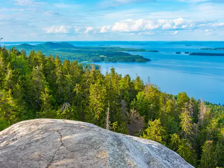
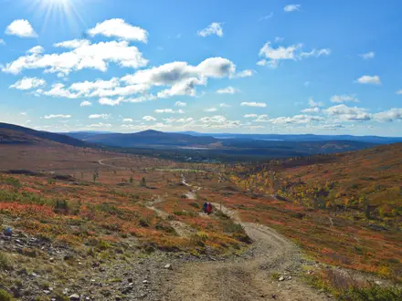
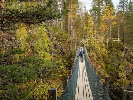
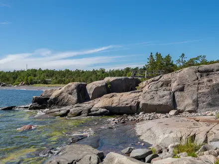
Saimaa Geopark Trails are not one long-distance route: they are a network of separate day walks, nature trails, cycling routes and canoeing routes around Lake Saimaa in eastern Finland. There is no continuous end-to-end distance; signature walking trails range roughly from 1.3 km to 13 km and are usually done in 1–5 hours. Difficulty is generally moderate, with forest paths, lakeshores, rocky outcrops and boardwalks. It suits hikers planning short walks between UNESCO Global Geopark geosites rather than a thru-hike.
Route Overview
There is no fixed start or finish for Saimaa Geopark Trails. The geopark covers sites across South Karelia and Southern Savonia, including Imatra, Lappeenranta, Mikkeli, Puumala, Ruokolahti, Sulkava and Taipalsaari. Walkers choose individual waymarked loops or short nature trails, then move between trailheads and geosites. Popular examples include Norppapolku in Puumala, Metsänväentaival in Juva and the Neitvuori/Hiiden trail area, covered separately as the Hiidenkierros Loop. Linnansaari is a separate lake national park area, not part of a continuous walk to Neitvuori or Astuvansalmi; see the Linnansaari National Park Trail for that setting. Some attractions, guided tours and boat transfers cost extra.
Geology, Ice Age Landscapes and Stone Age Rock Art
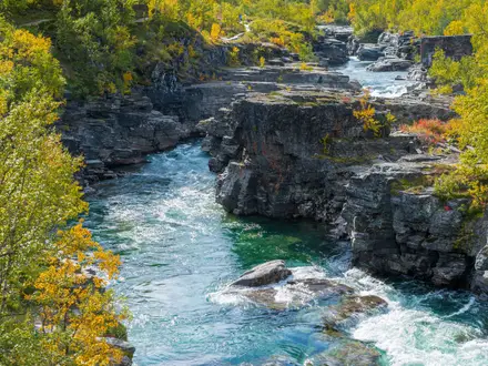
Saimaa Geopark’s story is geological and prehistoric. Its bedrock is around 1.9 billion years old, and the last Ice Age shaped the Lake Saimaa basin, leaving Salpausselkä terminal moraines, eskers such as Punkaharju and erratics such as Kummakivi. Lake Saimaa formed as the ice retreated, later draining through the Vuoksi. People have lived on these shores since the Stone Age; the Astuvansalmi rock paintings date to roughly 3000–2500 BC. The area became a UNESCO Global Geopark in 2021.
Notable highlights
- Astuvansalmi rock paintings: A lakeside cliff at Ristiina near Mikkeli with a major concentration of prehistoric Nordic rock art, including moose, people, boats and handprints. It is one of the most important cultural stops in the geopark.
- Neitvuori hill (~140 m): A regional high point reached by waymarked Hiiden and Neitvuori geological trails, with views over the Luonteri lake landscape and exposed Ice Age bedrock.
- Punkaharju esker ridge: A glacial pine ridge running between Lake Saimaa waters, with easy ridge-top walking and cycling in a protected landscape.
- Norppapolku ‘Seal Trail’ (~12.7 km): A Puumala trail interpreting the habitat of the Saimaa ringed seal, a critically endangered freshwater seal found only in Lake Saimaa.
- Kummakivi balancing rock: A well-known glacial erratic at Ruokolahti, where a large boulder rests on a rounded bedrock base left by retreating ice.
- Vuoksi and Imatrankoski rapids: Lake Saimaa drains through the Vuoksi; the historic Imatrankoski rapids at Imatra are a long-established Finnish visitor attraction.
Challenges to expect
The main challenge is planning: this is a dispersed trail network, not a continuous waymarked trek, so you must choose trailheads and sites in advance. Underfoot, expect roots, dirt paths, bare rock, wet sections and boardwalks. Some short trails have steep or rocky parts. Mosquitoes and midges can be heavy in midsummer, while winter use depends on snow conditions. Services are mostly in towns and bases rather than between trails.
HikeList Score
Saimaa Geopark Trails scored 79/100 on HikeList's trail-quality metrics.
See score breakdownHide breakdown
- Ideal length 55
- Balanced challenge 100
- Scenery & wildness 71
- Varied terrain 83
- Accommodation 75
- Food & support 88
- Path quality 98
- Season flexibility 89
Computed from length, challenge, scenery & wildness, terrain variety, accommodation, food & support, path quality and season flexibility.
Show more data Show less
- Forest
- Lakeshore
- Rocky Outcrops
- Dirt
- Rock
- Boardwalk
- Campsites
- Wild Camping Spots
- Hotels
- Family Friendly
- Pet Friendly
- Restrooms
- Water Sources
- Campsites
- Shelters
- Picnic Areas
Photos from hikers
Taken on the trail by people who've reviewed Saimaa Geopark Trails.
Reviews
How would you rate Saimaa Geopark Trails?
Tap a star to start your review — you could be the first.