Lagoa do Fogo Trail
How would you rate Lagoa do Fogo Trail?
Tap a star to share your experience and help other hikers.
Lagoa do Fogo Trail: São Miguel’s Crater Lake Hike
HikeList Score
Lagoa do Fogo Trail scored 78/100 on HikeList's trail-quality metrics.
See score breakdownHide breakdown
- Ideal length 55
- Balanced challenge 100
- Scenery & wildness 82
- Varied terrain 100
- Accommodation 74
- Food & support 54
- Path quality 87
- Season flexibility 89
Computed from length, challenge, scenery & wildness, terrain variety, accommodation, food & support, path quality and season flexibility.
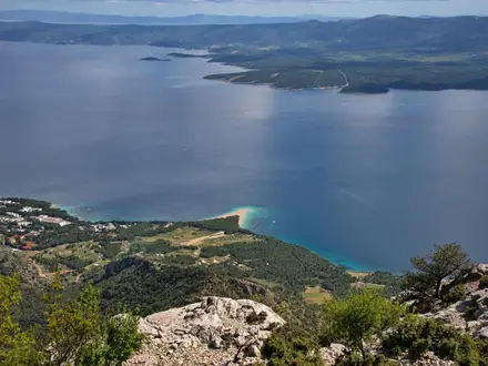
The Lagoa do Fogo Trail is the official PRC02 SMI day hike on São Miguel in the Azores, Portugal. It is an 11 km out-and-back route from the Ribeira da Praia / Água d’Alto area near Vila Franca do Campo to the shore of Lagoa do Fogo, a protected crater lake inside the Água de Pau volcanic massif. Allow about 4 hours. The trail is moderate: suitable for fit walkers who can handle a sustained climb, muddy levada sections and changeable cloud around the lake rim.
Route Overview
PRC02 SMI starts near Ribeira da Praia on São Miguel’s south coast and returns the same way. The route climbs on dirt road through farmland and pastures, passes the ruins of an old flax-fibre factory, then keeps right at a fork into Cryptomeria cedar woods. A muddy levada section leads towards water-abstraction works and a dam in the Ribeira da Praia valley before the path reaches the northern shore of Lagoa do Fogo. The return gives views back over the south coast and Ilhéu de Vila Franca. For another São Miguel crater walk, compare PR1 PDL Sete Cidades; for more levada-style walking, see Madeira Island Levada Walks.
Volcanic and Industrial History
Lagoa do Fogo fills a caldera in the Água de Pau Massif, the youngest volcano on São Miguel. The basin formed after collapses several thousand years ago, and the volcano’s last eruption was in 1563. The lake has been protected as a Natural Reserve since 1974 and is now part of São Miguel Natural Park. On the approach, the route passes ruins of a factory that processed New Zealand flax, plus a water-abstraction scheme begun in 1984 and completed in 1998 to collect spring water filtered through the basin.
Notable highlights
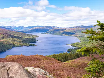
- Lagoa do Fogo crater lake (~575 m): A protected, undeveloped lake inside the Água de Pau volcano. No buildings are permitted around the basin, so the lake shore feels markedly wild.
- Old flax factory ruins: The route passes remains of a factory that processed Phormium tenax, or New Zealand flax. It is a clear link to São Miguel’s industrial past.
- Cryptomeria cedar woods and levada: The middle section runs through Japanese cedar forest and follows an old irrigation channel. Expect damp ground and Azorean flora such as Azorean blueberry and heather.
- Ribeira da Praia water-abstraction works: The trail enters an open, steep-sided valley where spring water filtered through the Lagoa do Fogo basin is collected.
- View over Ilhéu de Vila Franca: On the return, clear weather opens views to São Miguel’s south coast and the circular Vila Franca islet, a former crater used as a sea-pool nature reserve.
Challenges to expect
The main difficulty is the sustained climb from the south coast side, followed by muddy and uneven levada sections where waterproof footwear is useful. The route is well marked with Portuguese PR red-and-white paint, but fog and low cloud can hide lake views and make the higher ground feel less obvious. The lake-shore section can close when water levels are high, and seagulls may be territorial during the April–May breeding season.
HikeList Score
Lagoa do Fogo Trail scored 78/100 on HikeList's trail-quality metrics.
See score breakdownHide breakdown
- Ideal length 55
- Balanced challenge 100
- Scenery & wildness 82
- Varied terrain 100
- Accommodation 74
- Food & support 54
- Path quality 87
- Season flexibility 89
Computed from length, challenge, scenery & wildness, terrain variety, accommodation, food & support, path quality and season flexibility.
Show more data Show less
- Volcanic
- Forest
- Valley
- Lakeshore
- Coastal Views
- Dirt
- Gravel
- Muddy
- Rocky
- Paved
- Hotels
- Guesthouses
- Family Friendly
- Pet Friendly
- None
In these collections
Photos from hikers
Taken on the trail by people who've reviewed Lagoa do Fogo Trail.
Reviews
How would you rate Lagoa do Fogo Trail?
Tap a star to start your review — you could be the first.