Harzer Grenzweg (Border Trail)
Harzer Grenzweg (Border Trail): A Practical Hiking Guide
HikeList Score
Harzer Grenzweg (Border Trail) scored 89/100 on HikeList's trail-quality metrics.
See score breakdownHide breakdown
- Ideal length 81
- Balanced challenge 100
- Scenery & wildness 98
- Varied terrain 77
- Accommodation 91
- Food & support 88
- Path quality 80
- Season flexibility 89
Computed from length, challenge, scenery & wildness, terrain variety, accommodation, food & support, path quality and season flexibility.
The Harzer Grenzweg is a 91 km point-to-point hike through the Harz Mountains of Germany, following the former inner-German border along the Grünes Band nature corridor. It is usually walked in 3-6 days and is rated moderate: long rather than technical, with the steep Kolonnenweg climb to the Brocken the main physical test. It suits hikers who want a waymarked long-distance trail with forest, ridges, border history and village accommodation rather than remote camping.
Route Overview
The route is a north-south linear traverse, typically walked from the Grenzturm Rhoden / Großer Fallstein area near Osterwieck to the Grenzlandmuseum Tettenborn near Bad Sachsa, though it can be hiked either way. Key places include the Fallstein hills, Eckertalsperre, the Brocken at 1,141 m, Braunlage, Sorge, Hohegeiß, Walkenried and Bad Sachsa / Tettenborn. It is commonly split into six official stages, but fit walkers compress it into 3-4 days. The verified brief does not specify transport links, so check current access options for Osterwieck, Tettenborn and Bad Sachsa before booking. For other Harz routes, compare the Harzer Hexenstieg or a shorter Brocken Circuit.
Border history and the Green Belt
The Harzer Grenzweg follows the former inner-German border, fortified by the GDR from the 1950s until the border opened in 1989. After reunification, conservationists led by BUND recognised that the depopulated border strip had become a wildlife refuge and founded the Grünes Band in December 1989 to protect it. The Brocken was also a closed military zone in the GDR, with a Stasi/Soviet listening station on the summit.
Notable highlights
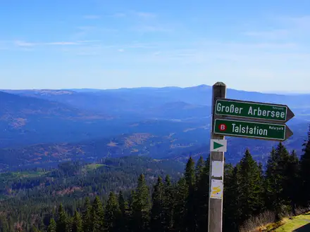
The Brocken (1,141 m): The highest point in the Harz and northern Germany. The trail reaches it via a steep Kolonnenweg; expect big views when the summit is clear, but frequent cloud and fog.
Kolonnenweg / Grünes Band: Long sections use the original perforated-concrete patrol track laid for GDR border troops. Today it forms part of the 1,400 km Green Belt wildlife corridor.
Eckertalsperre: This reservoir sat directly on the former border, with the frontier running through the dam area. The trail skirts the water on the approach towards the Brocken.
Sorge border memorials: The Freilandgrenzmuseum and Ring der Erinnerung near Sorge interpret the border landscape on the ground, with marked locations along the route.
Kloster Walkenried: Near the southern end, Walkenried has atmospheric Gothic ruins of a medieval Cistercian monastery, part of the wider UNESCO-listed Upper Harz mining heritage.
Bad Sachsa / Tettenborn: The Grenzlandmuseum Tettenborn marks the southern finish and is a fitting endpoint for the route’s Cold War theme.
Challenges to expect
Expect a moderate but sustained walk: 91 km, 1,633 m of ascent and long days if you compress the route. The steep Kolonnenweg climb to the Brocken is the hardest section, and the concrete slabs can be tiring underfoot. The Brocken is often in cloud or fog and can be snowbound in winter. Accommodation is in villages; wild camping is not allowed. On the Brocken, stay on marked Harz National Park paths.
HikeList Score
Harzer Grenzweg (Border Trail) scored 89/100 on HikeList's trail-quality metrics.
See score breakdownHide breakdown
- Ideal length 81
- Balanced challenge 100
- Scenery & wildness 98
- Varied terrain 77
- Accommodation 91
- Food & support 88
- Path quality 80
- Season flexibility 89
Computed from length, challenge, scenery & wildness, terrain variety, accommodation, food & support, path quality and season flexibility.
Show more data Show less
- Mountainous
- Forest
- Gravel
- Natural Path
- Footpath
- Asphalt
- Road
- Concrete Slabs
- Inns
- Guesthouses
- Hotels
- Family Friendly
- Pet Friendly
- Restrooms
- Water Sources
- Campsites
- Shelters
- Picnic Areas
Download Our Full Guide to Harzer Grenzweg (Border Trail) FREE!
Get our comprehensive guide to this hike for free. Save it for later reading or print out at home.
In these collections
Harzer Grenzweg (Border Trail): The Complete Guide
 i
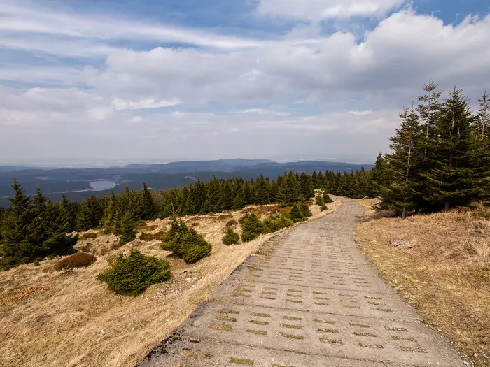
Image by ohenze
i
Image by ohenze The Harzer Grenzweg is a roughly 91 km north–south traverse of the Harz, following the former inner-German border from Grenzturm Rhoden near Osterwieck to Grenzlandmuseum Tettenborn near Bad Sachsa. It suits walkers who want a waymarked long-distance route with forest, ridges, Cold War history and proper town-to-town logistics rather than wilderness camping.
Much of the route follows the Kolonnenweg (border-patrol track), where perforated concrete slabs still mark the line once used by GDR border troops. That hard-edged history now sits inside the Grünes Band (Green Belt), a long wildlife corridor where birch, meadow and forest have reclaimed the old border strip.
The Brocken is the central prize and the hardest day: a steep climb to 1,141 m, often into cloud or fog, through the Nationalpark Harz. South of it, the trail drops towards Braunlage, Hohegeiß, Walkenried and the gypsum-karst country around Bad Sachsa and Tettenborn.
This is a moderate walk, not a technical one, but it still asks for fitness, weather judgement and careful booking. The Brocken and Braunlage nights are worth arranging ahead, public transport at both ends needs planning, and the concrete slabs can be more tiring than their gradient suggests.
This guide covers stages, walking days, accommodation, food, transport, terrain and the common mistakes to avoid.
Stage-by-Stage Guide
The stage notes below follow the six-stage version of the Harzer Grenzweg. Distances are approximate: the official headline distance is about 91 km, while the six published stages add up to a little more depending on the exact start, finish and access used.
Stage 1: Osterwieck / Grenzturm Rhoden to Wiedelah — approx. 14 km
The route begins at Grenzturm Rhoden, a preserved Grenzturm (border tower) near Osterwieck, and sets off south through the northern Harz foothills. This is one of the gentler stages, moving out from the Okeraue lowlands rather than tackling the main Harz heights straight away.
Underfoot, expect a mix of tracks, field-edge paths, gravel and sections linked to the former border corridor. The walking is not technically difficult, but wet weather can make lower-lying paths muddy, especially away from hard surfaces.
Wülperode is the main named village on the line before Wiedelah. The historical theme is present from the start: the route is not just crossing open countryside, but following the former inner-German border as it begins its long southward line towards the Harz.
Food and water should be planned around Osterwieck and Wiedelah rather than assumed on the trail itself. Carry enough for the day from the start, especially if beginning directly at Grenzturm Rhoden rather than in Osterwieck.
Accommodation is usually arranged in Osterwieck before the first stage and in or around Wiedelah at the end. Availability in smaller places can be limited, so book ahead rather than relying on turning up.
For access, Osterwieck has no railway station. The nearest railheads for the start are Ilsenburg, Vienenburg and Wernigerode, with onward regional buses to Osterwieck; current times should be checked before travelling. Parking is available at Rhoden for walkers using the Grenzturm start.
Navigation is straightforward in normal conditions: follow the green capital “G” waymark and the Grünes Band (Green Belt) signing. At the beginning, make sure the actual start point at Grenzturm Rhoden is clear, as Osterwieck itself is the practical service town but not the border-tower trailhead.
Stage 2: Wiedelah to Molkenhaus — approx. 21 km
This stage is longer and more varied, gradually moving from the northern approach into more enclosed Harz forest. It passes Abbenrode and Stapelburg before reaching the Eckertalsperre area and then Molkenhaus, a historic forest inn and former hunting house near Bad Harzburg.
The terrain becomes more recognisably Harz: forest tracks, dirt and gravel paths, narrower footpaths and stretches influenced by the old border infrastructure. The walking remains moderate, but the day is long enough to require an early start if carrying a full pack.
Eckertalsperre is the key landmark. The reservoir lay directly on the former border, with the frontier running through the dam, making this one of the most tangible places to understand the political geography of the route.
Molkenhaus is a long-standing walkers’ refreshment stop, but opening times and any services should be checked before relying on it. Carry food and water from Wiedelah, and do not assume that every village or forest stop will provide supplies when needed.
Accommodation at the end needs planning. The official stage ends at Molkenhaus, but many walkers will look to Bad Harzburg or Ilsenburg for beds nearby, or use a pre-arranged transfer if booked through a local operator. This should be checked before travelling, especially outside the main season.
Road access is easier around the settlements and near the Bad Harzburg / Ilsenburg side than in the forested middle of the stage. Public transport for intermediate points should not be assumed without checking current local timetables.
Navigation is generally well marked, but forest junctions around the Eckertal and Molkenhaus area deserve attention. Keep to the signed Harzer Grenzweg rather than taking inviting unsigned forest tracks, as many routes in this part of the Harz run close together.
Stage 3: Molkenhaus to Brocken — approx. 10 km
This is the shortest official stage by distance, but it is the crux of the Harzer Grenzweg. The route climbs through the Nationalpark Harz towards the Brocken, the 1,141 m high point of the trail and the highest summit in the Harz and northern Germany.
The defining feature is the steep Kolonnenweg (border-patrol track) climb. The old perforated-concrete slabs are hard and tiring underfoot, particularly on sustained gradients, and can feel more punishing than the distance suggests.
The Brocken is also the most exposed part of the walk. Cloud, fog and poor visibility are common, and winter conditions can bring snow; even in the main walking seasons, carry proper waterproofs, warm layers and navigation backup.
The historical setting is central to the stage. The Brocken was once a closed military zone in the GDR, with a Stasi and Soviet listening station on the summit; reaching it is both the physical and thematic centre of the route.
Food and water options are limited between Molkenhaus and the summit, so start with what is needed for the climb. Refreshment on or near the Brocken should not be relied on without checking opening times, particularly in poor weather or outside peak periods.
There is an option to stay on the Brocken, but beds should be booked well ahead. This is one of the key accommodation pressure points on the trail, especially for walkers following the six-stage itinerary exactly.
The Brocken is served by the Brockenbahn steam railway, which can be useful for access, bad-weather contingency or meeting non-walking companions. Timetables and operating conditions should be checked before travelling.
Within the Nationalpark Harz, stay on marked paths and follow any current path rules or diversion signs. Before setting off, check Brocken weather specifically rather than relying on conditions lower down in the valleys.
Stage 4: Brocken to Braunlage — approx. 13 km
Stage 4 leaves the summit environment and descends southwards towards Braunlage. After the exposed Brocken stage, this day is shorter and mostly downhill overall, but it still begins in high, weather-prone terrain.
Expect a mix of mountain tracks, forest paths and old border-route surfaces. The descent can be tiring on knees and feet, especially where hard surfaces or Kolonnenweg slabs remain underfoot.
The route drops past the Wurmberg area, close to Braunlage, before reaching one of the main service towns on the trail. In clear weather, this stage gives some of the best contrast on the route: from the open summit world of the Brocken down towards forest, meadows and the central Harz settlements.
Carry food and water from the Brocken unless current summit services and timings are certain. Braunlage has the practical advantage of being a proper overnight base, but do not leave the day’s supplies to chance before the descent.
Accommodation in Braunlage should be booked ahead. It is a key trail stop and a common overnight point for both six-day walkers and those compressing the route.
Road and transport access improve at Braunlage compared with the Brocken and the forested middle sections. Exact local bus links and onward connections should be checked before travelling, especially if joining or leaving the route here.
Navigation out of the Brocken area needs care in fog. Stay with the waymarked Harzer Grenzweg and do not be tempted onto alternative paths unless deliberately using a planned escape or transport option.
Stage 5: Braunlage to Hohegeiß — approx. 14 km
This is a moderate central-southern stage linking Braunlage with Hohegeiß via the border-history sites around Sorge. It is less severe than the Brocken climb, but it remains a proper walking day through Harz upland terrain.
The route uses forest tracks, natural paths, sections of the old Kolonnenweg and more open stretches through meadows and stream-valley country. After rain, expect mud in softer sections, and the concrete patrol slabs can still be uncomfortable over distance.
Elend and Sorge are the key places en route. Near Sorge, the Freiland-Grenzmuseum and Ring der Erinnerung provide one of the most important open-air border-memorial sections on the trail, with surviving fence, a border column, a watchtower, a water barrier and an earth bunker.
Benneckenstein lies near the route, while Hohegeiß is the official stage end. This is a good day to allow time for the historical sites rather than treating the stage as a fast transfer between overnight stops.
Food and water are most reliably planned around Braunlage and Hohegeiß. Any intermediate café, shop or museum-related facility should be checked before relying on it, as opening times can vary by season and weekday.
Accommodation is available in Hohegeiß, with Braunlage behind as the previous major base. Book ahead in busy walking periods and check whether luggage-transfer operators use exactly the same overnight stops as the six official stages.
Road access exists around the villages, but public transport details for intermediate points should be checked before travelling. Overnight guests in participating Harz accommodation may be able to use the HATIX guest card for free regional buses.
Navigation is usually uncomplicated, but the area around Sorge contains memorial features, local paths and the border route close together. Follow the green “G” waymark and allow extra time if collecting Harzer Wandernadel stamps along or near the route.
Stage 6: Hohegeiß to Bad Sachsa / Grenzlandmuseum Tettenborn — approx. 25 km
The final stage is the longest official day and should not be underestimated. It runs south from Hohegeiß towards the southern Harz, passing the Walkenried and Bad Sachsa area before finishing at the Grenzlandmuseum Tettenborn.
The character changes from upland forest and border-ridge walking towards the Südharzer Gipskarst, the southern Harz gypsum-karst landscape around Walkenried, Bad Sachsa and Tettenborn. Expect a varied day on tracks, paths, gravel and village approaches rather than one continuous high-level ridge.
Zorge lies near the route, and Walkenried is one of the main landmarks towards the latter part of the stage. Kloster Walkenried, the Gothic ruins of a 12th-century Cistercian monastery with the ZisterzienserMuseum, is a major cultural highlight close to the end of the trail.
The finish at Grenzlandmuseum Tettenborn gives the route a clear thematic endpoint. After following the Grünes Band and the old border infrastructure for almost the full traverse, the museum setting is a fitting place to end rather than simply stopping in a town centre.
Because this stage is long, start with a full day’s food and water from Hohegeiß. Walkenried and Bad Sachsa are the main practical service points near the southern end, but opening times and exact access from the line of the trail should be checked before relying on them.
Accommodation can be arranged in Walkenried, Bad Sachsa or nearby southern Harz settlements. Bad Sachsa is the usual practical finish base, while the trail itself ends at Tettenborn by the Grenzlandmuseum.
Walkenried is the key rail access point near the finish, on the Südharzstrecke (South Harz Railway). Bus lines 470 and 472 link Bad Sachsa and Tettenborn with Walkenried station, but current timetables should be checked before travelling; parking is available at the Grenzlandmuseum for those being collected by car.
Navigation is important at the end because the walking route, museum finish, Bad Sachsa accommodation and Walkenried rail access are not all the same place. Plan the final kilometres and onward transport in advance, especially if needing to catch a train from Walkenried the same day.
The main warning is fatigue rather than technical difficulty. The combination of a 25 km stage, cumulative trail mileage and possible mud after rain makes this a day for an early start, sensible pacing and enough daylight to reach Tettenborn without rushing.
Recommended Itinerary
Distances on the Harzer Grenzweg are best treated as approximate. The headline route is about 91 km, while the six official day-stages add up to nearer 97 km depending on mapping and exact start/end points, so accommodation should be booked around stage towns rather than a falsely precise kilometre figure.
Standard itinerary: 6 walking days
This is the most balanced plan for independent walkers. It follows the published six-stage structure, keeps the Brocken climb short enough to manage in poor weather, and avoids turning the final 25 km into the middle of a longer day.
| Day | From | To | Approx. distance | Why this stage makes sense | Services/accommodation notes |
|---|---|---|---|---|---|
| 1 | Osterwieck / Grenzturm Rhoden | Wiedelah | 14 km | A manageable opening stage from the northern foothills, useful if arriving the previous day into Osterwieck and starting from the Grenzturm (border tower) at Rhoden. | Osterwieck is the practical pre-walk base; parking is available at Rhoden. Check accommodation availability in Wiedelah before booking the rest of the route. |
| 2 | Wiedelah | Molkenhaus | 21 km | A fuller day that moves the route into the forested Harz approach and positions you well for the Brocken ascent. | Molkenhaus is a historic forest inn and long-standing walkers’ stop. Accommodation around Molkenhaus / Bad Harzburg / Ilsenburg should be arranged in advance, as beds are thinner through the middle of the route. |
| 3 | Molkenhaus | Brocken | 10 km | Short on paper but one of the key days: the route climbs steeply on the Kolonnenweg (border-patrol track) to the 1,141 m Brocken. The shorter distance gives time for poor visibility, wind, snow patches outside summer, and the tiring concrete slabs underfoot. | An overnight on the Brocken is possible but should be booked ahead. Check Brocken weather and any Nationalpark Harz path advice before setting out. |
| 4 | Brocken | Braunlage | 13 km | A controlled descent day after the high point, keeping the exposed summit section separate from the longer southern stages. | Braunlage is one of the stronger accommodation bases on the route and should be booked ahead in busy periods. |
| 5 | Braunlage | Hohegeiß | 14 km | A moderate linking day through the southern Harz border landscape, with time to take in the border-history sites around Sorge without rushing. | Hohegeiß has stage accommodation, but availability should still be checked before committing to dates. Overnight guests may be able to use the HATIX guest card for regional buses. |
| 6 | Hohegeiß | Bad Sachsa / Grenzlandmuseum Tettenborn | 25 km | The longest official day, crossing the southern Harz landscape towards Walkenried, Bad Sachsa and the Grenzlandmuseum Tettenborn finish. Start early, especially if onward transport is needed the same day. | Walkenried is the useful rail point on the Südharzstrecke near the southern end. Bus lines 470/472 link Bad Sachsa and Tettenborn with Walkenried station; current times should be checked before travelling. Parking is available at the Grenzlandmuseum Tettenborn. |
Slower variant: 7 days or 6 days plus a buffer night
A slower plan suits walkers who want more time for the Brocken, the Freiland-Grenzmuseum and Ring der Erinnerung near Sorge, Kloster Walkenried, or the Grenzlandmuseum Tettenborn. It is also the safer choice in unsettled weather, as the Brocken can be foggy, windy or snow-affected outside the main season.
The simplest slower version is to follow Days 1–5 of the standard itinerary, then split the long Hohegeiß to Tettenborn finish with an extra night around Walkenried or Bad Sachsa.
| Day | From | To | Approx. distance | Why this stage makes sense | Services/accommodation notes |
|---|---|---|---|---|---|
| 1–5 | As standard | As standard | 10–21 km per day | Keeps the northern approach, Brocken climb and Braunlage / Hohegeiß stages at comfortable lengths. | Book the Brocken and Braunlage nights early. |
| 6 | Hohegeiß | Walkenried or Bad Sachsa | Part of the 25 km final stage; check official mapping before booking | Breaks the longest day and gives more time for the southern Harz gypsum-karst landscape and Kloster Walkenried. | Walkenried has the Südharzstrecke rail link. Accommodation in Walkenried or Bad Sachsa should be booked before fixing this split. |
| 7 | Walkenried or Bad Sachsa | Grenzlandmuseum Tettenborn | Remaining part of the final stage; check official mapping before booking | Allows a shorter final walk and more time at the Grenzlandmuseum Tettenborn before leaving the trail. | Use Walkenried station and the Bad Sachsa / Tettenborn bus links only after checking current timetables. |
Faster variant: 4 days
A four-day crossing is realistic only for fit walkers who are comfortable with long days on forest tracks, gravel, natural paths and sections of perforated concrete Kolonnenweg. Luggage transfer (Gepäcktransport) makes this plan more practical; carrying a heavy pack makes the Brocken day and final day noticeably harder.
| Day | From | To | Approx. distance | Why this stage makes sense | Services/accommodation notes |
|---|---|---|---|---|---|
| 1 | Osterwieck / Grenzturm Rhoden | Molkenhaus | About 35 km | Combines the first two official stages to make rapid progress from the northern start into the Harz forest. This is a long first day and should not be treated as a casual arrival walk. | Arrange the start from Osterwieck / Rhoden carefully. Accommodation around Molkenhaus / Bad Harzburg / Ilsenburg must be secured before setting out. |
| 2 | Molkenhaus | Braunlage | About 23 km | Combines the Brocken climb with the descent towards Braunlage, putting the hardest central terrain into one demanding mountain day. | Start early, check Brocken weather, and book Braunlage ahead. In poor conditions, this day can take longer than the distance suggests. |
| 3 | Braunlage | Hohegeiß | 14 km | A shorter recovery day after the Brocken section, still keeping the route moving south. | Hohegeiß accommodation should be booked in advance. |
| 4 | Hohegeiß | Bad Sachsa / Grenzlandmuseum Tettenborn | 25 km | A long but logical final stage to the southern terminus, with Walkenried and Bad Sachsa providing useful exit options near the end of the route. | Check Südharzstrecke trains from Walkenried and connecting buses between Bad Sachsa, Tettenborn and Walkenried before travelling. |
A three-day itinerary is possible only by creating very long custom stages from the official route. It is not the best fit for most walkers, because accommodation spacing, the Brocken weather window and the 25 km southern stage all become less forgiving; check official mapping before booking any three-day version.
Planning the Route
How many days to allow
Most walkers should plan around the six published stages rather than trying to make the route artificially even. The accommodation and transport points are unevenly spaced, and the short-looking Brocken stage is short for a reason: it includes the steep Kolonnenweg climb and the most exposed weather on the trail.
A five-day itinerary can work if one of the easier or shorter sections is combined, but only after accommodation has been secured. A three- or four-day crossing is realistic for fit walkers travelling light, but it turns the Harzer Grenzweg into a series of long hill days with little spare time for the border museums, Harzer Wandernadel stamps or poor weather on the Brocken.
| Plan | Best for | Main trade-off |
|---|---|---|
| 6 days | Most walkers; anyone wanting time for the border sites and the Brocken | More overnight bookings, but the easiest rhythm |
| 5 days | Fit walkers who still want a reasonably practical town-to-town plan | Requires careful combining of stages and bed availability |
| 3–4 days | Strong walkers with light packs and early starts | Long days, less weather margin, harder logistics |
Let accommodation shape the itinerary
The route is best planned from bed to bed, not just from map point to map point. Osterwieck, Wiedelah, Braunlage, Hohegeiß, Walkenried and Bad Sachsa are the main practical settlement names to work around, with the Brocken and the Molkenhaus area needing particular attention.
Beds are thinner through the more remote middle of the route, so the Brocken and Braunlage nights should be booked ahead. If a stage ending at Molkenhaus does not suit available accommodation, look carefully at the Bad Harzburg / Ilsenburg side of the route and arrange any local transfer before committing to the rest of the itinerary. This should be checked before travelling.
Wild camping is not permitted, and much of the key central section lies in or near the Nationalpark Harz. Planning should therefore assume booked accommodation every night, or a self-guided package with Gepäcktransport (luggage transfer) where offered by local operators.
Direction of travel
The trail is conventionally walked north to south, from Grenzturm Rhoden near Osterwieck to Grenzlandmuseum Tettenborn near Bad Sachsa. This gives a natural build-up from the northern foothills to the Brocken and finishes at one of the route’s main border-history sites.
Walking south to north is possible, but it changes the feel of the hard central section. The Kolonnenweg slabs on the Brocken are tiring in either direction; in reverse, the steep concrete descent can be hard on knees and awkward in wet, foggy or wintry conditions.
Using the official stages sensibly
The six-stage pattern is useful because it follows the available settlements and the natural shape of the hills, even though the distances are uneven. Treat the figures as approximate: the headline route length is usually given at about 91 km, while stage totals and digital tracks can come out a little longer.
| Stage | Planning note |
|---|---|
| Osterwieck / Grenzturm Rhoden to Wiedelah | A relatively manageable opening day, but the start itself is outside the nearest town accommodation, so arrange access to Rhoden carefully. |
| Wiedelah to Molkenhaus | A longer day moving into the forested Harz; check food, water and overnight logistics before relying on services en route. |
| Molkenhaus to Brocken | Short on paper but physically important. Allow time for the steep Kolonnenweg climb and for poor visibility on the summit. |
| Brocken to Braunlage | Weather can still dominate the early part of the day. Braunlage is a key overnight stop, so book ahead in busy periods. |
| Braunlage to Hohegeiß | A more moderate linking stage through the southern Harz, with Sorge and its border memorials close to the route. |
| Hohegeiß to Bad Sachsa / Grenzlandmuseum Tettenborn | The longest published stage and one that deserves an early start, especially if visiting Walkenried, Bad Sachsa or the museum at the finish. |
Shortening, extending and section hiking
The Harzer Grenzweg is straightforward to section-hike in principle, but not every village has simple rail access. The most practical rail point near the southern end is Walkenried on the Südharzstrecke, with buses linking Walkenried station, Bad Sachsa and Tettenborn. Current bus and train times should be checked before travelling.
At the northern end, Osterwieck has no railway station. Access normally needs a rail approach to Ilsenburg, Vienenburg or Wernigerode, then a regional bus connection such as line 270 from Ilsenburg to Osterwieck. Rhoden and the Grenzturm start then need a final local access plan.
For a shorter trip, it is usually better to walk a coherent section between transport points than to force unofficial shortcuts across the route. For a longer trip, add time for the Brocken, Sorge, Kloster Walkenried or the Harzer Wandernadel stamp stations rather than stretching the daily walking beyond what the accommodation pattern supports.
Food, water and daily resupply
Do not assume continuous services between stage ends. The route passes towns, villages and walkers’ refreshment points such as Molkenhaus, but opening hours can vary, and the more remote middle stages need a full day’s food and water carried from the start of the day.
The safest approach is to buy breakfast supplies, lunch food and snacks in the overnight settlements wherever possible, and start each day with enough water to reach the next certain stop. Museum visits, the Brocken summit and forest inns should be planned as bonuses unless their current opening times have been checked.
Navigation and route checks
The route is waymarked by the Harzklub with a green capital G and the Grünes Band logo, so navigation is generally straightforward in good conditions. A GPX track or offline map is still worth carrying, especially in forest, fog, snow patches or where temporary forestry and path works affect the line.
Check live trail closures and diversions before setting off. The central national-park section is not a place for improvising off-path alternatives; stay on marked paths and follow local signage.
Weather planning
The Brocken is the main weather decision point. It is often in cloud or fog, and in winter it can be snowbound, so the summit day needs proper waterproofs, warm layers and enough time to move slowly on the concrete slabs.
An early start is sensible for the Brocken climb and the long final stage to Bad Sachsa / Tettenborn. If the forecast is poor, the six-day itinerary gives more room to adjust than a compressed three- or four-day schedule.
Transport and luggage logistics
Both ends of the trail need more planning than the walking itself. There is parking at Rhoden for the start and at Grenzlandmuseum Tettenborn for the finish, but public-transport users should build the itinerary around the railheads and bus links rather than assuming a simple town-centre station at either end.
Overnight guests may be able to use the HATIX guest card for free regional buses, which can help with local transfers and section hiking. Eligibility, current coverage and timetables should be checked with accommodation providers before booking.
Self-guided packages with Gepäcktransport are available from local operators and can make the route much easier if walking the full trail with light day packs. Confirm stage endpoints, luggage rules and accommodation locations directly before relying on a package.
Towns, Villages and Overnight Stops
The Harzer Grenzweg is best planned as a town-to-town walk, but the spacing is uneven. The northern foothill villages are useful for pacing and orientation, while the most important accommodation decisions are around Molkenhaus, the Brocken, Braunlage, Hohegeiß and the Bad Sachsa / Walkenried finish area.
In the smaller villages, do not rely on turning up and finding meals, shops or a bed without checking first. Wild camping is not permitted, and much of the central route is within the Nationalpark Harz, so overnight plans need to be fixed before starting each day.
Grenzturm Rhoden / Osterwieck
The trail starts at Grenzturm Rhoden, a preserved Grenzturm (border tower) near Rhoden in the Großer Fallstein / Okeraue area. Rhoden has parking, but Osterwieck is the practical pre-walk base and the nearest town named for accommodation.
This is the best place to stay the night before the hike if walking north to south. Do not expect meaningful hiker services at the tower itself; treat it as the trailhead, not as a supply point.
Osterwieck has no railway station. The nearest useful railheads for reaching the start are Ilsenburg, Vienenburg and Wernigerode, with onward regional bus connections; line 270 from Ilsenburg to Osterwieck takes around 30 minutes. Current bus and train times should be checked before travelling, especially if arriving late in the day.
Wülperode
Wülperode comes early on the northern section after the route leaves the Rhoden / Osterwieck area. For most walkers it is a pass-through village rather than a planned overnight stop.
Use it mainly as a navigation and pacing point on the first stage. Food, shop and accommodation availability should be checked before travelling if planning to rely on anything here.
Wiedelah
Wiedelah is the official end of the first day-stage from Osterwieck / Grenzturm Rhoden, at roughly 14 km. It is therefore the first logical overnight stop on the full six-stage itinerary.
Because accommodation information for Wiedelah can be more limited than for the larger Harz towns, book ahead rather than assuming a bed will be available on arrival. The same applies to evening meals and breakfast arrangements; this should be checked before travelling.
Abbenrode
Abbenrode sits on the second northern stage between Wiedelah and the climb towards the Harz proper. It is useful as a mid-stage landmark, but not one of the main overnight anchors of the route.
Treat Abbenrode as a small-village stop unless specific services have been arranged in advance. If compressing the trail into longer days, it is still worth noting because the early stages can feel logistically easier than the more remote Brocken approach, but that should not encourage casual planning around unconfirmed services.
Stapelburg
Stapelburg is another useful settlement on the route before the trail moves towards the Eckertalsperre and the more forested central Harz. It can help break up the long official second stage towards Molkenhaus.
It is not one of the main published overnight stops in the standard six-stage plan. Food, shops and accommodation should be checked before travelling if using Stapelburg as anything more than a pass-through point.
Eckertalsperre
Eckertalsperre is not a town or village, but it is an important practical point on the route. The reservoir lay directly on the former inner-German border, with the frontier running through the dam, and the trail skirts the water on the approach towards the Brocken area.
There should be no assumption of accommodation or general services here. Carry enough food and water for the section, particularly if continuing towards Molkenhaus or climbing higher into the Nationalpark Harz.
Molkenhaus
Molkenhaus is the official end of the second stage from Wiedelah and a long-standing walkers’ stop near Bad Harzburg / Ilsenburg. It is a historic Waldgaststätte (forest inn) and former hunting house, so it is a natural place to pause before the harder Brocken section.
Accommodation planning here needs care. The wider Bad Harzburg / Ilsenburg area is named as one of the practical accommodation zones for the route, but the central stages have thinner bed availability than the towns lower down, so do not leave this night unbooked.
This is also the last sensible point to reassess weather and timing before the Brocken climb. The next official stage is short in distance at around 10 km, but the Kolonnenweg (border-patrol track) slabs and the exposed summit conditions can make it feel much harder than the mileage suggests.
Brocken
The Brocken, at 1,141 m, is the high point of the Harzer Grenzweg and the official end of the third stage. It is a dramatic overnight option because it breaks the central traverse neatly: Molkenhaus to Brocken, then Brocken to Braunlage.
Beds on or around the Brocken should be booked well ahead. This is one of the places on the route where accommodation is specifically worth securing early, especially in the main walking season and around weekends.
Do not plan to bivouac or wild camp here. The route crosses the Nationalpark Harz, and walkers should stay on marked paths and follow current national-park rules.
The Brockenbahn steam railway serves the summit area, which can be useful for contingency planning, but it should not replace checking the day’s weather. The Brocken is frequently in cloud, fog and, in winter, snow; visibility and wind can change the practical difficulty of the stage.
Wurmberg
Wurmberg lies near the route on the descent south from the Brocken towards Braunlage. It is a useful landmark in the central Harz, but not an official overnight stop on the six-stage Harzer Grenzweg itinerary.
Most hikers continue to Braunlage for the night rather than trying to use Wurmberg as a logistics base. Any side trip, food stop or transport plan involving Wurmberg should be checked before travelling.
Braunlage
Braunlage is the official end of the fourth stage from the Brocken and one of the key accommodation towns on the route. It is a strong place to reset after the high-level central section, with hotels, Pensionen and inns forming part of the normal accommodation style for this trail.
Book Braunlage ahead. Along with the Brocken, it is one of the nights most likely to need advance planning, particularly if using a luggage-transfer package or walking during busy periods.
Braunlage is also a sensible place to deal with practical errands before the southern half of the trail: check meal arrangements, confirm the next night in Hohegeiß, and carry what is needed for the quieter sections through Elend, Sorge and towards the southern Harz.
Elend
Elend sits between Braunlage and Sorge on the official fifth stage towards Hohegeiß. For many walkers it is a daytime village stop rather than a planned overnight.
Services should not be assumed without checking. Its main value for planning is as a point on the approach to Sorge and the border-history sites that follow.
Sorge
Sorge is one of the most important interpretive stops on the southern half of the Harzer Grenzweg. The Freiland-Grenzmuseum and Ring der Erinnerung sit near the route, with surviving border features including fencing, a border column, a watchtower, a water barrier and an earth bunker.
Allow time here if the Cold War border history is a major reason for walking the trail. It is not just a quick village name on the map; it is one of the places where the former frontier is easiest to understand on the ground.
For overnight logistics, Sorge is not one of the main stage-end accommodation bases in the standard six-day plan. Food, museum opening times and any local services should be checked before travelling.
Benneckenstein
Benneckenstein lies near the route rather than as a principal stage endpoint. It may be relevant when adapting the itinerary, but it is not one of the standard overnight stops used in the six official stages.
If using Benneckenstein as an alternative stop, check the route connection, accommodation and transport before committing to it. Do not assume it will fit neatly into the waymarked Harzer Grenzweg without a short off-route plan.
Hohegeiß
Hohegeiß is the official end of the fifth stage from Braunlage and the final major overnight before the long southern stage to Bad Sachsa / Grenzlandmuseum Tettenborn. It is one of the accommodation bases named for the route, with hotels, Pensionen and inns forming the usual options.
This is an important booking point because the next official day is around 25 km, the longest stage in the published six-day structure. Sort evening food, breakfast and next-day supplies here rather than relying on uncertain options during the final section.
Hohegeiß is also a sensible place to check the next day’s transport plan. If finishing at Tettenborn and then moving on by bus or rail, current bus times and Südharzstrecke connections via Walkenried should be checked before travelling.
Zorge
Zorge lies near the route on the southern approach towards Walkenried and Bad Sachsa. It can be useful as a landmark or as part of a customised itinerary, but it is not the main official stage-end stop.
Treat services here as something to verify in advance. If shortening the long Hohegeiß to Bad Sachsa / Tettenborn day, any accommodation or transport plan involving Zorge should be arranged before setting out.
Walkenried
Walkenried is one of the most useful southern logistics points on the Harzer Grenzweg. It is near the route close to the finish, has accommodation options within the normal trail pattern, and is served by the Südharzstrecke railway.
The station at Walkenried is especially important because neither Osterwieck nor central Bad Sachsa has a directly convenient mainline trailhead station. For many walkers, Walkenried is the most practical rail connection at the southern end of the hike.
Walkenried is also worth planning around for Kloster Walkenried and the ZisterzienserMuseum, close to the southern Harz Gipskarst landscape. Opening times should be checked before travelling if the monastery visit is part of the itinerary.
Bus lines 470 and 472 link Bad Sachsa and Tettenborn with Walkenried station. Overnight guests in the Harz may be able to use the HATIX guest card for free regional buses, but eligibility and current coverage should be checked with accommodation providers.
Bad Sachsa
Bad Sachsa is the main accommodation base near the southern end of the Harzer Grenzweg. It is named in the route’s standard accommodation pattern and is more practical for a final night than trying to stay at the museum terminus itself.
Although Bad Sachsa is associated with the finish, it does not have a central station directly at the trail end. Walkenried station on the Südharzstrecke is the key rail link, with bus lines 470 and 472 connecting Bad Sachsa and Tettenborn to Walkenried.
Bad Sachsa works well either as the last overnight before visiting Grenzlandmuseum Tettenborn or as a finish base after completing the route. Check bus times carefully if the final day depends on a same-day train connection.
Tettenborn / Grenzlandmuseum
Grenzlandmuseum Tettenborn is the southern terminus of the Harzer Grenzweg and the appropriate endpoint for the route’s border-history theme. There is parking at the museum, making it useful for private transfers or pick-up arrangements.
Do not assume Tettenborn itself will work as a full-service overnight stop. Most walkers should plan accommodation in Bad Sachsa or Walkenried, then use local buses, a pre-arranged transfer or onward travel from Walkenried station.
Museum opening times and current bus connections should be checked before travelling. This matters particularly on the final day, when the official stage from Hohegeiß is long and a missed connection can turn a clean finish into an awkward evening transfer.
Getting to the Start
The Harzer Grenzweg starts at Grenzturm Rhoden, a preserved Grenzturm (border tower) near Osterwieck in the northern Harz foothills. The practical access point is Osterwieck/Rhoden rather than a railway station, so the final approach needs planning, especially for an early start.
By train
Osterwieck has no railway station. The nearest useful railheads are Ilsenburg, Vienenburg and Wernigerode, from where you need an onward regional bus or taxi connection towards Osterwieck and Rhoden.
Ilsenburg is the clearest public-transport approach: bus line 270 links Ilsenburg with Osterwieck in around 30 minutes. Current rail and bus times should be checked before travelling, particularly at weekends, on public holidays and if aiming to start walking the same day.
For walkers arriving from elsewhere in Germany, plan the rail journey to one of the regional stations first, then treat Osterwieck/Rhoden as a separate local-transfer leg. Do not assume that the final bus connection will run late in the evening.
By bus
Regional buses provide the onward link into Osterwieck, with line 270 from Ilsenburg being the specific connection to plan around. From Osterwieck, the trailhead is at Grenzturm Rhoden rather than in the town centre, so the last hop to Rhoden may still require a taxi, accommodation transfer or careful local bus planning.
This should be checked before travelling. Timetables, stop locations and service frequency can change, and rural Harz bus services may be sparse outside core daytime hours.
If staying locally before the hike, ask the accommodation in Osterwieck whether they can advise on the easiest way to reach Grenzturm Rhoden in the morning. Overnight guests in the Harz may be eligible for the HATIX guest card, which gives free use of regional buses; eligibility and validity should be confirmed with the host when booking.
By car
There is parking at Rhoden near the start, which makes car access straightforward for walkers being dropped off or those arranging a private transfer back after the hike. If leaving a vehicle there for several days, confirm locally that multi-day parking is permitted and practical before committing to the plan.
Because this is a point-to-point walk ending at Grenzlandmuseum Tettenborn near Bad Sachsa, parking at the start creates a return-logistics problem. The practical rail link near the southern end is Walkenried on the Südharzstrecke, with buses linking Bad Sachsa and Tettenborn to Walkenried station, but the onward journey back to Rhoden/Osterwieck will still need careful timetable planning.
A common alternative is to use public transport to reach the start and avoid returning for a car at the end. If using luggage transfer or a self-guided package, confirm where the operator expects you to start and whether transfers to Grenzturm Rhoden are included.
From the nearest airport
Hannover is the main air gateway for this route. From there, continue by rail towards the northern Harz railheads such as Ilsenburg, Vienenburg or Wernigerode, then use a regional bus or taxi for the final approach to Osterwieck/Rhoden.
Allow generous time between the flight arrival and the local transfer. The weak link is not the long-distance journey, but the final rural connection to Osterwieck and the trailhead at Grenzturm Rhoden. This should be checked before travelling.
Where to stay before starting
Osterwieck is the nearest town for accommodation before starting the Harzer Grenzweg. Staying there makes the first morning much simpler than arriving by train and bus on the same day, especially if walking the official first stage to Wiedelah.
If accommodation in Osterwieck is unavailable, consider staying near one of the approach railheads such as Ilsenburg, Vienenburg or Wernigerode, but only if the morning bus or taxi connection to Osterwieck/Rhoden is workable. For a reliable early start, pre-book any taxi rather than relying on one being available on arrival.
Getting Home from the Finish
The Harzer Grenzweg finishes at the Grenzlandmuseum Tettenborn, near Bad Sachsa. It is a meaningful endpoint for the trail, but it is not a major transport hub, so plan the final transfer before setting out for the last stage.
By train
The practical rail link at the southern end is Walkenried, which lies on the Südharzstrecke (South Harz Railway). This regional line runs between Northeim, Herzberg, Bad Lauterberg, Bad Sachsa, Walkenried and Nordhausen.
From Walkenried, plan onward rail travel via the Südharzstrecke towards Northeim or Nordhausen, then connect as needed for longer-distance journeys. Exact connections and interchange times are timetable-dependent and should be checked before travelling.
Bad Sachsa is not a simple central-station finish for the walk. Treat Walkenried station as the most useful rail access point unless a current timetable gives a better connection for your specific journey.
By bus
Bus lines 470 and 472 link Bad Sachsa and Tettenborn with Walkenried station. These are the key public-transport connections for leaving the Grenzlandmuseum Tettenborn without a car.
Services are regional rather than turn-up-and-go city transport, so do not assume a late bus will be available after a long final day from Hohegeiß. Check the current timetable before committing to a same-day train connection.
If staying locally, ask your accommodation about the HATIX guest card. Overnight guests can use it for free regional bus travel, which can be useful for reaching Walkenried station the next morning.
By car/taxi
There is parking at the Grenzlandmuseum Tettenborn, which makes the finish straightforward if a car has been left there in advance. This is often the simplest arrangement for groups using two vehicles or for walkers being collected.
If the car is at the northern start near Grenzturm Rhoden, the return journey is more awkward and will involve a combination of bus, rail and possibly taxi. Do not leave this to the end of the walk without checking current services.
A taxi is the most reliable fallback for reaching Bad Sachsa, Walkenried station or local accommodation after a late finish. Book ahead where possible, especially outside normal daytime hours; availability and prices should be checked locally.
From the nearest airport
Hannover is the main air gateway for the Harz region. From the finish, the usual approach is to travel out by regional rail from Walkenried on the Südharzstrecke, then connect onwards towards a larger rail hub for airport travel.
Exact airport connections vary by date, time of day and rail works. Check the full journey from Walkenried or Bad Sachsa to Hannover Airport before booking flights, and leave a sensible buffer if finishing the trail the same day.
Where to stay at the finish
Bad Sachsa is the most useful overnight base at the southern end of the route, with Walkenried also practical because of its station on the Südharzstrecke. Staying overnight is sensible if you expect to finish late, want to visit the Grenzlandmuseum Tettenborn properly, or need an early onward train.
An overnight stop also makes the HATIX guest card useful for the final bus connection to Walkenried station. Confirm whether your accommodation provides the card and check which bus services fit your departure time.
Which Direction Should You Walk?
The Harzer Grenzweg is conventionally walked north to south, from Grenzturm Rhoden near Osterwieck to Grenzlandmuseum Tettenborn near Bad Sachsa. It is fully waymarked and can be walked in either direction, but the official six-stage structure is set out northbound-to-southbound in reverse only with a little more planning.
North to south: the standard direction
North to south is the simplest choice for most walkers. The trail starts in the lower Okeraue and northern Harz foothills, then builds steadily towards the Eckertal, Nationalpark Harz and the Brocken before dropping into the southern Harz around Braunlage, Hohegeiß, Walkenried and Bad Sachsa.
This direction gives the route a clear progression: border tower and lowland Green Belt sections first, the Brocken as the central high point, then the open-air border history around Sorge, the southern Harz gypsum karst and the museum finish at Tettenborn. Ending at Grenzlandmuseum Tettenborn also works well thematically, as the trail’s Cold War border story has a proper closing point rather than simply stopping at a road or village.
The main physical drawback is that the steep Kolonnenweg (border-patrol track) climb to the Brocken is faced as an ascent. The perforated concrete slabs are tiring underfoot, so this stage should not be treated as an easy short day just because the distance is modest.
Transport is manageable but not seamless. Reaching the start usually means travelling by train to Ilsenburg, Vienenburg or Wernigerode, then using a regional bus to Osterwieck and local onward arrangements to Rhoden. Finishing in the south can be slightly more convenient because Walkenried is on the Südharzstrecke and lies near the route, with bus links between Bad Sachsa, Tettenborn and Walkenried station; current timetables should be checked before travelling.
South to north: the reverse direction
Walking south to north is perfectly possible, but it is less intuitive. It starts with the southern Harz and the Grenzlandmuseum Tettenborn, then works back through Bad Sachsa, Walkenried, Hohegeiß, Braunlage and the Brocken before finishing in the northern foothills near Osterwieck.
The main advantage is that the steep Kolonnenweg section to the Brocken is more likely to be tackled as a descent rather than a climb. That may suit walkers who dislike sustained steep uphill, but the concrete slabs can be awkward and jarring downhill, especially when wet, icy or under fatigue.
Reverse direction also makes the finish less convenient for many public-transport plans. Ending near Rhoden/Osterwieck still leaves the issue that Osterwieck has no railway station, so a bus connection to Ilsenburg, Vienenburg or Wernigerode is normally needed. This should be checked before travelling, especially on weekends or public holidays.
Accommodation is not a major reason to choose reverse, but it does need booking with care. The thin bed supply around the remote middle of the route, particularly Brocken and Braunlage nights, matters in both directions. If using a self-guided package with Gepäcktransport (luggage transfer), confirm that the operator will run the itinerary south to north before booking.
Weather and the Brocken
There is no clear route-specific weather advantage to either direction. The important factor is timing the Brocken stage sensibly: the summit is frequently in cloud, fog and, in winter, snow, and the exposed high ground should be taken seriously whichever way the route is walked.
For a six-day itinerary, both directions can place the Brocken around the middle of the walk. For a compressed three- or four-day crossing, the direction affects where the longest days fall, so stage planning should be built around accommodation availability and the Brocken forecast rather than direction alone.
Recommendation
Walk the Harzer Grenzweg north to south unless there is a specific transport, accommodation or package reason to reverse it. The official stage flow is clearer, the landscape builds naturally towards the Brocken, public transport is usually a little easier at the southern end, and the finish at Grenzlandmuseum Tettenborn gives the route the strongest sense of completion.
Accommodation Along the Route
The Harzer Grenzweg works well as an inn-to-inn walk, but it is not a route where every stage-end has a deep accommodation pool. The strongest bases are Osterwieck, Braunlage, Hohegeiß, Walkenried and Bad Sachsa, with Bad Harzburg / Ilsenburg useful around the Molkenhaus section. The main pinch points are the Brocken night and the official Molkenhaus / Wiedelah stage pattern, where accommodation choice is more limited or may require a transfer.
Wild camping is not permitted, and this matters particularly through the Nationalpark Harz and the Brocken section. Plan around booked beds rather than assuming bivouac options, shelters or informal camping will solve a long day.
Best Overnight Stops
| Place | Accommodation level | Best for | Notes |
|---|---|---|---|
| Osterwieck | Good | Night before starting at Grenzturm Rhoden | Nearest practical town for the northern trailhead. Parking is available at Rhoden, but Osterwieck is the better accommodation base. |
| Wülperode / Abbenrode / Stapelburg | Limited | Possible intermediate stops or short-stage planning | These are route villages rather than the main accommodation hubs. Availability should be checked before building an itinerary around them. |
| Wiedelah | Limited | Official first-stage stop | Works as a stage end in the six-day schedule, but do not assume broad choice. Book ahead or check nearby alternatives before committing. |
| Molkenhaus area | Limited | Breaking the approach to the Brocken | Molkenhaus is a historic forest inn and walkers’ refreshment stop near Bad Harzburg / Ilsenburg. For overnight planning, nearby Bad Harzburg or Ilsenburg may be more practical; this should be checked before travelling. |
| Bad Harzburg / Ilsenburg | Good | Accommodation base for the northern Brocken approach | Useful if the official Molkenhaus stage end does not suit, or if using taxi / luggage-transfer support around this section. |
| Brocken | Limited | A memorable high-point overnight and shorter Brocken stages | There is an option to stay on the Brocken, but beds are limited and should be booked well ahead, especially in good-weather periods, weekends and holidays. Weather can also affect plans here. |
| Braunlage | Good | Main central-route overnight hub | One of the most useful accommodation stops on the trail, especially after crossing the Brocken. Book ahead: it is a popular Harz walking base. |
| Elend / Sorge / Benneckenstein | Limited | Shorter stages between Braunlage and Hohegeiß | Useful for flexible itineraries, but accommodation choice is not as strong as Braunlage or Bad Sachsa. Check availability before relying on these as overnight stops. |
| Hohegeiß | Good | Official penultimate overnight stop | A practical base before the long final stage towards Bad Sachsa and Tettenborn. |
| Zorge | Limited | Alternative southern Harz stop near the route | Potentially useful for adapting the Hohegeiß–Bad Sachsa section, but not a primary stage hub in the six-day schedule. |
| Walkenried | Good | Rail access, Kloster Walkenried and southern-route logistics | On the route near the southern end and useful for section-hikers, especially because Walkenried is on the Südharzstrecke railway. |
| Bad Sachsa | Good | Final night after finishing at Grenzlandmuseum Tettenborn | The main accommodation base near the southern terminus. Bus links connect Bad Sachsa / Tettenborn with Walkenried station; current timetables should be checked before travelling. |
| Tettenborn | Limited | Finish at Grenzlandmuseum Tettenborn | Best treated as the trail endpoint rather than the main overnight base. Bad Sachsa is usually the more practical place to stay. |
Booking Strategy
Book the Brocken and Braunlage nights first. These are the accommodation-sensitive points in the middle of the route: the Brocken has limited beds, while Braunlage is a popular Harz resort and the natural stop after the summit crossing.
Next, fix the start and finish nights. Osterwieck is the logical pre-walk base for Grenzturm Rhoden, and Bad Sachsa is the practical end base after reaching Grenzlandmuseum Tettenborn.
The official six-stage itinerary includes Wiedelah and Molkenhaus, but those stops need more care than the larger towns. If accommodation is not available exactly where needed, use Bad Harzburg, Ilsenburg, Walkenried or Bad Sachsa as support bases and arrange a taxi, bus connection or luggage-transfer itinerary around the gap.
Luggage Transfer and Supported Itineraries
The Harzer Grenzweg is suitable for walkers who want town-to-town accommodation rather than carrying camping kit. Local hosts and operators offer self-guided packages with Gepäcktransport (luggage transfer), which can make the route easier to organise where accommodation is thin or where stage ends do not line up neatly with available beds.
This is especially useful around the Molkenhaus / Brocken / Braunlage section and for walkers shortening or lengthening the official six-day schedule. Confirm the exact overnight places, transfer rules and baggage limits directly with the operator before booking.
Practical Accommodation Advice
Avoid leaving accommodation open-ended on the central stages. The route passes through forest and national park terrain, and there are long sections where simply walking on to the next village may mean a much bigger day than planned.
For a relaxed six-day walk, the standard pattern is Osterwieck, Wiedelah, Molkenhaus area, Brocken, Braunlage, Hohegeiß and Bad Sachsa. For a faster three- or four-day crossing, accommodation choice becomes more important because the long days must finish in reliable hubs such as Braunlage, Hohegeiß, Walkenried or Bad Sachsa.
Overnight guests in participating Harz accommodation may receive the HATIX guest card for free regional buses. This can help with short transfers to and from accommodation, but current validity, routes and timetables should be checked before travelling.
Camping and Wild Camping
The Harzer Grenzweg is better planned as an inn-to-inn walk than as a camping trek. The official stage structure is built around towns, villages and established accommodation stops such as Osterwieck, Wiedelah, Molkenhaus, the Brocken, Braunlage, Hohegeiß and Bad Sachsa, rather than a chain of campsites.
Wild camping should not be used as a planning strategy on this route. Much of the central section passes through the Nationalpark Harz on the approach to and crossing of the Brocken, and wild camping is not permitted. The route also follows sensitive Grünes Band (Green Belt) habitats and crosses a mix of protected land, forest and private land, so discreet “just one night” camping is not an acceptable substitute for booking accommodation.
Campsites and legal camping options
Do not assume there is a campsite at each stage end. The reliable accommodation pattern for this trail is hotels, Pensionen, Gasthöfe and inns in or near the stage towns, with the Brocken and Braunlage nights especially worth booking ahead.
If carrying camping equipment, plan around legal campsites off or near the route and be prepared to alter stage lengths or use local transport. Availability around practical trail towns such as Osterwieck, Bad Harzburg / Ilsenburg, Braunlage, Hohegeiß, Walkenried and Bad Sachsa should be checked before travelling.
A camping-based itinerary is likely to be less straightforward than a guesthouse itinerary. It may require detours, bus links, longer road approaches at the start or end of the day, and careful checking of where camping is actually allowed.
Wild camping, protected areas and fires
Wild camping is not permitted on the Harzer Grenzweg, and the Nationalpark Harz section around the Brocken is the key area where this matters most. Stay on marked paths, particularly in the national park and on the Grünes Band corridor, where the former border strip is now an important conservation area.
Do not camp beside the Eckertalsperre, on the Brocken, along the Kolonnenweg, in forest clearings, at border memorial sites, or near the Freiland-Grenzmuseum and Ring der Erinnerung at Sorge. These are walking and heritage areas, not informal camping spots.
Open fires should be treated as off-limits in practice. Forest, national-park and conservation restrictions can change with season and fire risk; current fire and stove rules should be checked locally before travelling.
Water and camping practicality
There is no reason to plan this route around untreated natural water. The safer approach is to fill bottles at accommodation, cafés, inns and towns, then carry enough for each stage.
This matters most on the longer or more exposed days: the approach to the Brocken, the Brocken crossing in poor weather, and the long final stage from Hohegeiß towards Bad Sachsa and Tettenborn. Do not rely on streams, reservoirs or forest water sources as part of the camping plan.
Leave No Trace expectations
Even when using legal campsites or formal accommodation, keep the trail impact low:
- stay on the waymarked Harzklub route and any signed diversions;
- take all litter out, including food waste;
- avoid disturbing wildlife in the Grünes Band corridor;
- do not damage border remains, fences, concrete slabs or museum structures;
- keep noise down near villages, memorials and forest edges;
- use toilets in towns, accommodation and visitor facilities rather than the trail corridor.
For most walkers, the most practical “camping” decision is not to camp: book beds, carry a lighter pack, and use the Harzer Grenzweg as the town-to-town mountain traverse it is designed to be.
Food, Water and Resupply
Food and water logistics are straightforward in the stage towns, but patchier on the actual walking line. The Harzer Grenzweg is not a wilderness route, yet several sections spend long hours on forest tracks, Kolonnenweg (border-patrol track), reservoir paths and national-park terrain with no guaranteed shop or café directly on the trail.
The safest approach is to book accommodation that provides breakfast, carry a packed lunch or buy food before leaving each town, and treat any café, inn or museum stop as a bonus unless current opening hours have been checked.
Food availability
The most useful resupply bases are the larger overnight places: Osterwieck, Braunlage, Hohegeiß, Walkenried and Bad Sachsa, with Bad Harzburg / Ilsenburg also relevant around the Molkenhaus side of the route. These are the places to organise evening meals, breakfast supplies and next-day food.
Smaller places on or near the route — including Wülperode, Wiedelah, Abbenrode, Stapelburg, Elend, Sorge, Benneckenstein, Zorge and Tettenborn — should not be relied on for full resupply without checking. Some may have limited food options, seasonal opening or no convenient shop on the walking line.
Molkenhaus is a historic Waldgaststätte (forest inn) and long-standing walkers’ refreshment stop, so it is an important planned food stop on the northern half of the route. Opening days and kitchen hours can change, especially outside the main season, so this should be checked before travelling.
The Brocken is a special case. It has accommodation options and is served by the Brockenbahn railway, but the summit is exposed, weather-dependent and busy in good conditions. If staying on or crossing the Brocken, do not depend on being able to buy all food at the last minute; carry enough to get down to Braunlage if necessary.
Water strategy
Start each day with full bottles from accommodation. Tap-water refills are most reliable at hotels, guesthouses, inns and cafés; public drinking-water points should not be assumed.
Natural water is present in the landscape — including the Eckertal, the Eckertalsperre area and stream valleys south of the Brocken — but it should not be treated as ready to drink. If taking water from streams, springs or reservoirs, filter or treat it first, and avoid drawing water where there is obvious contamination, livestock access or stagnant flow.
For most walkers, 1.5–2 litres is a sensible normal carry between settlements in mild conditions. On the Brocken climb, in hot weather, or on the long Hohegeiß to Bad Sachsa / Tettenborn stage, carry more and do not wait for an uncertain refill.
Sunday and seasonal closures
Germany has widespread Sunday and public-holiday shop closures, and rural opening hours can be short. Bakeries, cafés, inns and restaurants may open when supermarkets are closed, but this varies by place and season.
This matters most if a stage starts on a Sunday morning or public holiday. Buy lunch and emergency food the previous day, especially before the Molkenhaus–Brocken, Brocken–Braunlage and Hohegeiß–Bad Sachsa stages.
Section-by-section food and water planning
| Section | Food availability | Water availability | Notes |
|---|---|---|---|
| Grenzturm Rhoden / Osterwieck to Wiedelah | Best arranged in Osterwieck before starting. Do not assume useful resupply at every small village on the line. | Fill up before leaving Osterwieck or accommodation. Refill opportunities depend on village services. | A relatively short first stage, but the start at Grenzturm Rhoden is not a town-centre resupply point. Carry lunch/snacks from Osterwieck. |
| Wiedelah to Molkenhaus | Limited and variable once away from settlements. Stapelburg is on the route, but services should be checked before relying on it. Molkenhaus is the key refreshment stop. | Fill bottles before leaving Wiedelah. Natural water near the Eckertal / Eckertalsperre area should be filtered or treated if used. | One of the more important food-carry stages. Molkenhaus opening hours should be checked before travelling. |
| Molkenhaus to Brocken | No routine shop resupply on the climb. Food depends on what is available at Molkenhaus and on the Brocken. | Start full. The Brocken climb is hard work and exposed; do not rely on natural water. | Short in kilometres but strenuous on the Kolonnenweg slabs. Carry enough food and water to continue safely if the summit is in fog or facilities are busy/closed. |
| Brocken to Braunlage | Food may be available on the Brocken if staying there, but carry breakfast/lunch supplies as a fallback. Braunlage is the main resupply point at the end of the stage. | Fill before leaving the Brocken accommodation if possible. Refill reliably in Braunlage. | Weather can make this feel longer than the distance suggests. Braunlage is the best place to restock before the southern stages. |
| Braunlage to Hohegeiß | Braunlage is the place to buy food before departure. Elend and Sorge are on the way, but services should not be assumed without checking. Hohegeiß has overnight facilities. | Start full from Braunlage. Refill at cafés/inns if open; otherwise carry enough for the full day. | The route passes the Freiland-Grenzmuseum / Ring der Erinnerung area near Sorge, where museum interest can slow the day. Pack lunch rather than depending on a timed stop. |
| Hohegeiß to Bad Sachsa / Grenzlandmuseum Tettenborn | Treat this as the longest food-carry day. Walkenried and Bad Sachsa are the practical resupply areas near the southern end, but check opening times. | Carry more than usual from Hohegeiß. Refill in serviced places such as accommodation, cafés or inns where available. | At roughly 25 km, this is the longest official stage. Do not arrive at Tettenborn expecting meaningful resupply at the museum finish; plan the finish-day meal around Bad Sachsa or Walkenried. |
Navigation and Waymarking
The Harzer Grenzweg is an official, waymarked long-distance trail and is generally suitable for walkers with ordinary navigation skills. It is signposted by the Harzklub and marked with a green capital “G” for Grenzweg on a white ground, often alongside the Grünes Band (Green Belt) logo.
Do not treat the waymarking as a substitute for navigation, especially if compressing the route into longer days. Forest junctions, settlement edges and any temporary diversions can still cost time, and the Brocken is frequently affected by cloud, fog or winter snow.
What to use on the trail
A GPX track is strongly recommended. The route is waymarked, but a downloaded track makes it much easier to confirm the correct line through forest tracks, on and off the Kolonnenweg (border-patrol track), and around towns such as Braunlage, Hohegeiß, Walkenried and Bad Sachsa.
Use an offline mapping app with topographic detail rather than relying on mobile data. Download the full route, day sections and the surrounding map tiles before setting off, as mobile signal should not be assumed in the forested Harz or around the Brocken.
A paper walking map is also sensible as a backup, particularly for the Nationalpark Harz section and for anyone using accommodation slightly off the line of the route. No specific paper map sheet should be bought without checking current coverage for the full Osterwieck–Brocken–Bad Sachsa corridor.
Where navigation needs more care
The northern stages from Grenzturm Rhoden towards Wiedelah and Stapelburg are not technically difficult, but the route uses a mix of tracks, paths and village approaches. Pay attention where the trail leaves minor roads or switches between field-edge tracks and woodland.
The approach through the Eckertal and towards Molkenhaus brings more forest navigation. Junctions can look similar, so keep the GPX visible rather than walking on autopilot.
The Brocken stage is the key navigation pinch point. The climb is on steep Kolonnenweg slabs and the summit area is often in cloud or fog; in poor visibility, follow the marked route and avoid cutting corners inside the Nationalpark Harz. Winter snow can obscure markings and make the concrete slabs awkward underfoot.
South of the Brocken, the route passes the Wurmberg area and continues via Braunlage, Elend, Sorge, Hohegeiß, Walkenried, Bad Sachsa and Tettenborn. The walking is not technical, but town exits, museum detours and accommodation access points are where most wrong turns are likely.
Closures, diversions and national-park rules
Live path closures and diversions should be checked before travelling. The Harzer Grenzweg has at times been affected by path works, and any temporary signage on the ground takes priority over an older GPX file.
In the Nationalpark Harz, stay on marked paths and follow local signs. This is particularly important on the Brocken section, where weather, conservation rules and winter conditions can all affect how straightforward the day feels.
Is it suitable for less experienced navigators?
Yes, provided the weather is reasonable and the route is walked with a GPX track or reliable map backup. The Harzer Grenzweg is not a wilderness navigation route and has official waymarks throughout, but it is still a 91 km point-to-point walk through forest, ridges, towns and exposed high ground.
Walkers with limited navigation experience should avoid making the Brocken stage their first test in bad weather. Start early, keep the next stage-end and escape options clear, and check the route line at every major junction rather than waiting until a mistake becomes obvious.
Terrain, Conditions and Difficulty in Practice
The Harzer Grenzweg is best treated as a moderate mountain-and-forest walk with one genuinely strenuous mountain section, rather than a technically difficult trek. The route is waymarked and has no alpine scrambling or exposed ridge walking, but the surfaces, weather and cumulative ascent make it more demanding than the distance alone suggests.
Underfoot, expect a mix of forest tracks, dirt and gravel paths, narrower natural footpaths and long stretches of Kolonnenweg — the former GDR border-patrol track made from perforated concrete slabs. That concrete is one of the defining features of the walk: historically important, easy to follow in places, but tiring on the feet and awkward when wet, icy or partly broken.
Main path surfaces
The easiest walking is on the broader forest and gravel tracks through the Harz woods and along the lower approaches. These sections are generally straightforward for any walker used to long-distance paths, though they can still become muddy after sustained rain.
Narrower natural paths occur through forest, ridge and valley terrain. These are not technical, but roots, wet soil and leaf litter can slow progress, especially in poor visibility or after bad weather.
The Kolonnenweg (border-patrol track) is the surface most likely to surprise walkers. The perforated concrete slabs are hard underfoot, uneven in rhythm and can be uncomfortable over long stretches. Walking poles and footwear with a firm sole help reduce fatigue, particularly on descents and on the climb to the Brocken.
Climbs, descents and the Brocken crux
The route rises from the low northern Okeraue area towards the central Harz and reaches its high point on the Brocken at 1,141 m. Total ascent is around 1,633 m, spread across the full route, so the walk is not continuously steep but does contain sustained climbing.
The hardest section is the steep Kolonnenweg climb to the Brocken. This is the point where the trail moves beyond easy forest walking: the gradient, concrete slabs and exposed summit weather combine to make it physically demanding. It deserves proper mountain clothing, an early start and enough food and water to manage delays.
The descent south from the Brocken towards the Braunlage side is less of a headline difficulty, but tired legs, hard surfaces and changing weather can still make it slow. Do not judge the whole route by the gentler northern stages; the central mountain section is the practical crux.
Weather and ground conditions
The Harz can be wet, misty and cold even when the surrounding lowlands are mild. Mud is most likely after rain on natural tracks and forest paths, while concrete and gravel sections can become slippery.
The Brocken is frequently in cloud, fog or winter snow. Poor visibility on the summit area can make a well-waymarked route feel more serious, and wind chill can be significant on the exposed high ground. Check the Brocken forecast before setting out, particularly if staying high or crossing the summit late in the day.
Winter conditions can change the character of the walk substantially. Snowbound paths, icy concrete slabs and fog on the Brocken increase both effort and navigation risk, so the usual hiking season is spring, summer and autumn rather than winter.
How the difficulty changes along the route
The northern stages from the Grenzturm Rhoden / Osterwieck area towards Wiedelah and onward towards the Harz foothills are generally the most forgiving. They still require steady daily mileage, but the terrain is less mountainous than the central section.
The approach through the Eckertal and Nationalpark Harz towards Molkenhaus and the Brocken becomes progressively more demanding. This is where fitness, weather judgement and footwear matter most.
South of the Brocken, the trail drops past the Wurmberg area and continues through mountain meadows, forest, stream valleys and eventually the southern Harz Gipskarst landscape around Walkenried, Bad Sachsa and Tettenborn. The final official stage from Hohegeiß to Bad Sachsa / Grenzlandmuseum Tettenborn is long, so its difficulty comes more from distance and accumulated fatigue than technical ground.
Roads, fields, gates and obstacles
This is not primarily a road-walking route. Some hard-surface walking is likely around towns, villages and access points, but the character of the trail is forest, ridge, valley and former border track rather than tarmac.
Livestock fields, stiles and frequent farm gates are not a defining feature of the Harzer Grenzweg. Historic border fences and installations are part of the interpretation at places such as Sorge and Tettenborn, not normal trail obstacles.
Practical difficulty rating
For a fit walker carrying day kit and using booked accommodation, the Harzer Grenzweg is a realistic moderate long-distance hike. The waymarking, settlement-based stages and lack of technical terrain make it accessible, but it should not be underestimated.
It becomes harder if compressed into three or four days, if the Kolonnenweg is wet or icy, or if the Brocken is in fog, snow or strong wind. The most reliable approach is to plan conservative stage lengths around the Brocken, keep waterproofs and warm layers accessible, and allow extra time wherever the route uses long sections of concrete border track.
Weather and Best Time to Walk
Spring, summer and autumn are the normal seasons for the Harzer Grenzweg. The route is not technical, but weather matters because it crosses the Brocken at 1,141 m and uses long stretches of Kolonnenweg (border-patrol track), which can be tiring, slippery or awkward underfoot when wet or snow-covered.
The most reliable planning window is from late spring through early autumn, when daylight is better and the Brocken stage is less likely to be affected by snow. Autumn can be an excellent time for walking, but shorter days make the long final stage from Hohegeiß to Bad Sachsa / Tettenborn less forgiving, especially if the ground is muddy.
Seasonal planning
| Season | What to expect | Planning advice |
|---|---|---|
| Spring | Generally suitable, but higher ground around the Brocken can still feel wintry early in the season. Paths and forest tracks may be muddy after rain. | Treat the Brocken day as a mountain day, not just a forest walk. Check the Brocken weather before setting off and carry layers for cold, cloud and wind. |
| Summer | The easiest season for daylight and usually the simplest for completing the route in 3–6 days. The concrete Kolonnenweg slabs can still be hard on feet over long distances. | Book accommodation ahead, particularly around the Brocken and Braunlage. Start early on compressed itineraries and on the long Hohegeiß–Bad Sachsa / Tettenborn day. |
| Autumn | Often practical, but daylight becomes the limiting factor and wet leaves, mud and fog can slow progress. The Brocken is frequently clouded over. | Allow more time than the map suggests on the Brocken approach and descent. Keep a headtorch accessible if walking the longer stage plan. |
| Winter | The least suitable season for a standard thru-hike. The Brocken can be snowbound, fog is common, and the exposed summit section can become a serious weather obstacle. | Only realistic for walkers equipped and experienced for winter upland conditions. Check Brocken weather, live route conditions and Nationalpark Harz path rules before travelling. |
The Brocken is the weather crux
The central Brocken stage is the section most likely to disrupt plans. The climb uses steep Kolonnenweg slabs and reaches the highest point in the Harz and northern Germany, where cloud and fog are frequent and winter snow is a real factor.
Do not plan the Brocken day on the assumption of views or easy navigation by sightline. Even on a waymarked route, poor visibility can make progress slower, and the concrete slabs are more tiring when wet. A waterproof shell, warm layer and reliable offline mapping are sensible outside the most settled summer conditions.
Rain, mud and trail surface
The Harzer Grenzweg uses forest tracks, gravel and dirt paths, narrower footpaths and original perforated-concrete patrol slabs. After rain, muddy sections are likely, especially through forest and meadow terrain, while the Kolonnenweg can feel harsh and uneven rather than technically difficult.
Footwear should be chosen for wet forest walking and hard surfaces. Lightweight shoes may be comfortable in dry summer weather, but many walkers will prefer supportive hiking shoes or boots for the Brocken climb, long concrete sections and the final 25 km stage.
Daylight and itinerary length
A six-day itinerary gives the most weather margin, especially around the Brocken. Compressing the route into 3–4 days makes early starts much more important because delays from fog, mud or slow concrete walking can quickly affect arrival times.
The final official stage from Hohegeiß to Bad Sachsa / Grenzlandmuseum Tettenborn is about 25 km, so it deserves particular attention in spring and autumn when daylight is shorter. If using public transport at the finish or staying off-route, check current bus and train times before committing to a late arrival.
Accommodation and seasonal constraints
Wild camping is not permitted, and much of the route passes through the Nationalpark Harz, where walkers should stay on marked paths. Accommodation therefore shapes the schedule as much as weather does.
Beds are thinner in the more remote middle of the route, and nights on or around the Brocken and in Braunlage should be booked ahead in any walking season. Temporary path works, diversions, Brocken weather and any current Nationalpark Harz rules should be checked before travelling.
Safety Notes
The Harzer Grenzweg is a moderate, waymarked mountain walk rather than a technical route, but it still needs proper hill-walking judgement. The main safety issues are the exposed Brocken stage, long stretches through forest, tiring Kolonnenweg (border-patrol track) slabs, changeable weather and the logistics of a point-to-point route with limited escape options in the middle stages.
Emergency help
In Germany, call 112 for emergency medical, fire and rescue assistance. Carry ID, health insurance details and enough battery to make an emergency call.
Mobile reception should not be assumed to be continuous, particularly in forested sections and around the Nationalpark Harz. Download offline mapping, carry a power bank, and make sure at least one person knows the day’s intended stage and overnight stop.
Brocken weather and exposure
The Brocken is the key weather hazard on the route. At 1,141 m it is frequently in cloud and fog, and in winter it can be snowbound; visibility can drop quickly even when lower sections are clear.
Check the Brocken forecast before committing to the Molkenhaus–Brocken and Brocken–Braunlage stages. In poor visibility, stay on the marked route, avoid shortcuts, and allow extra time for slower navigation and colder conditions on the summit area.
Carry windproof and waterproof layers even in settled seasons. In spring and autumn, gloves and a warm layer are sensible for the Brocken stage; in hot summer weather, the lower and more sheltered sections can still require extra water and sun protection.
Kolonnenweg surfaces
Long sections use the original Kolonnenweg, the perforated concrete slabs laid for GDR border patrols. These are historically important, but they are hard underfoot and can be tiring over distance.
Expect awkward footing, repeated small steps and trip hazards, especially when tired or carrying a heavy pack. After rain, surrounding dirt and gravel paths can be muddy, and wet concrete should be treated cautiously on steeper ground, particularly on the climb towards the Brocken.
Supportive footwear is strongly recommended. Trekking poles can help on the steeper Kolonnenweg sections and on long descents.
Navigation, closures and national-park rules
The route is waymarked by the Harzklub with the green G and Grünes Band markings, but do not rely only on paint and signs. Carry an offline GPX or mapping app and a backup method of navigation.
Before setting off each day, check for live trail closures, diversions and any partial-closure signage. This is especially important in and around the Nationalpark Harz, where path rules apply and walkers should stay on marked routes.
Do not shortcut through sensitive Grünes Band habitat or closed national-park areas. The former border corridor is now an important conservation zone, not just a walking line.
Long and remote-feeling sections
The route passes towns and villages, but some middle sections feel remote, particularly around Eckertalsperre, Molkenhaus, the Brocken and the forested ground beyond. If compressing the trail into 3–4 days, fatigue becomes a real safety factor.
Start early on the Brocken stage and on the longer final stage from Hohegeiß towards Bad Sachsa and Tettenborn. Carry enough food and water to finish the day without relying on every refreshment stop being open.
If walking solo, avoid pushing on into darkness or poor weather just to keep to a booked itinerary. Know the nearest practical exit points and check current bus or rail options before starting the day if a shorter escape may be needed.
Roads, villages and everyday hazards
Road walking is not the defining risk of the Harzer Grenzweg, but the trail enters and leaves settlements such as Osterwieck, Wiedelah, Braunlage, Hohegeiß, Walkenried and Bad Sachsa. Take normal care on village streets, road crossings and access lanes, especially in poor visibility or at dusk.
The route also passes meadows and stream valleys. Use signed paths, keep dogs under close control where required, and treat livestock calmly if encountered.
Water, reservoirs and drinking water
The trail passes water features including Eckertalsperre and several stream valleys, but there is no need to plan for river fords or tidal hazards. The main water issue is carrying enough between services, especially on warmer days and longer compressed stages.
Do not rely on untreated surface water as a drinking source. Fill up before leaving towns, accommodation or known services, and carry more than usual for the Brocken climb or hot weather.
Daily pre-start checklist
Before leaving each morning, check:
- Brocken and Harz mountain weather, especially fog, wind, snow risk and thunderstorms.
- Current trail closures, diversions and Nationalpark Harz path rules.
- Daylight time for the planned distance, particularly if compressing stages.
- Whether the day’s food, water and refreshment options are realistic.
- Accommodation check-in arrangements at Brocken, Braunlage, Hohegeiß or Bad Sachsa.
- Current bus and train times if using Walkenried, Bad Sachsa/Tettenborn connections or any escape route.
- Phone battery, offline maps, emergency contact plan and basic first-aid kit.
Gear Recommendations
The Harzer Grenzweg is not a technical mountain route, but it does need proper walking kit. The two gear challenges are the long sections of Kolonnenweg (border-patrol track) made from hard perforated concrete slabs, and the Brocken, where fog, wind and snow can make a short stage feel much more serious than the map suggests.
Footwear
Wear supportive hiking shoes or lightweight boots with a firm sole. The Kolonnenweg is tiring underfoot because the concrete slabs are hard, uneven and perforated; very flexible trail shoes can leave feet sore by the end of a long day.
After rain, forest paths and natural tracks can be muddy, so good grip matters. Waterproof footwear is useful in spring and autumn, but avoid over-heavy boots unless walking in colder or wetter conditions.
Waterproofs and warm layers
Pack a proper waterproof jacket and a warm mid-layer even in summer. The route climbs from low foothills to the Brocken at 1,141 m, and the summit is frequently in cloud, fog and poor weather.
A hat and gloves are sensible outside high summer, especially if staying on or crossing the Brocken early or late in the day. In winter or wintry spring conditions, the Brocken can be snowbound; extra insulation, traction aids and a more conservative plan may be needed. This should be checked before travelling.
Navigation
The route is waymarked by the Harzklub with the green “G” for Grenzweg and Grünes Band (Green Belt) signage, but do not rely on waymarks alone. Carry an offline map or GPX track, plus enough phone battery to navigate if fog closes in on the Brocken or if a diversion is signed for path works.
A paper map is still worthwhile for independent hikers, especially because the trail is a point-to-point route with awkward public-transport access at both ends. It also helps if adjusting a stage into Bad Harzburg, Ilsenburg, Braunlage, Hohegeiß, Walkenried or Bad Sachsa.
Water and food carry
Carry enough water for each full stage rather than assuming frequent refills on the trail. The official stages link towns, villages and overnight stops, but the forested middle of the route is thinner on services, particularly around the approach to the Brocken.
Food planning depends on the itinerary. Inn-to-inn walkers can usually resupply around stage towns such as Osterwieck, Braunlage, Hohegeiß, Walkenried and Bad Sachsa, but should still carry lunch, snacks and an emergency reserve. Molkenhaus is a long-standing walkers’ refreshment stop, but opening times and seasonal arrangements should be checked before travelling.
Trekking poles
Trekking poles are useful on this trail, particularly on the steep Kolonnenweg climb to the Brocken and on long descents over hard surfaces. They reduce leg fatigue on the concrete slabs and help with balance if the holes, edges or wet sections become awkward.
Poles are less essential on the gentler northern and southern stages, but fast hikers compressing the route into three or four days will benefit from them.
Power and electronics
Bring a power bank if using a phone for navigation, accommodation details, bus connections or the Harzer Wandernadel stamp locations. A single charge may be enough for short stages in good weather, but fog, cold and continuous GPS use can drain batteries quickly.
Keep electronics dry. A simple waterproof phone pouch or dry bag is enough for most walkers.
Sun, insects and small extras
The route is mainly forest-and-ridge walking, but open sections on the Grünes Band and around the Brocken can still be exposed. Pack sun cream, sunglasses and a cap in summer.
Insect repellent can be useful in warmer months, especially through forest, meadow and stream-valley sections. A small first-aid kit should include blister care, as the hard Kolonnenweg surface is a common cause of foot problems.
Inn-to-inn hikers
For most walkers using hotels, Pensionen, Gasthöfe and inns, a light but weatherproof day-to-day setup is ideal: 25–35 litre pack, waterproofs, warm layer, lunch, water, navigation, headtorch and basic repair items. If using Gepäcktransport (luggage transfer), keep all safety essentials with you rather than sending them ahead.
Book key overnight stops such as the Brocken and Braunlage ahead, then pack around fixed stages. The Brocken stage may be only around 10 km in the official itinerary, but it is the crux of the route and should not be treated as a casual half-day without mountain-weather clothing.
Campers
Do not plan this as a wild-camping route. Wild camping is not permitted, and much of the route passes through the Nationalpark Harz, where walkers should stay on marked paths and follow national-park rules.
Camping gear only makes sense if using lawful, pre-arranged campsites or accommodation off the route. Exact camping options are not part of the standard Harzer Grenzweg logistics and should be checked before travelling. For most hikers, inn-to-inn accommodation is the more practical setup.
Fast and section hikers
Fast hikers compressing the trail into three or four days should prioritise foot comfort, weather protection and efficient resupply over an ultralight but fragile kit list. Long days over concrete slabs are harder on feet and joints than the moderate elevation profile suggests.
Section hikers can travel lighter, especially on the northern and southern stages, but the Brocken section still needs full waterproofs, warm layers and reliable navigation. If using buses or the Südharzstrecke at Walkenried, carry enough charge and offline timetable information in case connections are missed or weather slows progress.
Budget and Costs
The Harzer Grenzweg is best budgeted as a town-to-town inn and guesthouse walk rather than a cheap camping trek. Costs are driven mainly by how many nights you take, whether you stay on or near the Brocken, and whether you add Gepäcktransport (luggage transfer) or taxis to smooth out the awkward start and finish.
Exact prices vary by season, room type and booking channel, so current rates should be checked before booking. Budget in euros (€).
Main cost drivers
| Cost | What to budget for | Cost note |
|---|---|---|
| Accommodation | Hotels, Pensionen, Gasthöfe and Gasthäuser in Osterwieck, Wiedelah, Braunlage, Hohegeiß, Walkenried, Bad Sachsa and nearby stage towns | The biggest fixed cost. Beds are thinner in the remote middle of the route; Brocken and Braunlage should be booked ahead. |
| Food | Breakfasts, packed lunches, snacks and evening meals | Do not assume regular shops or cafés on every section, especially around the Brocken and longer forest stages. Carry lunch and spare food where the next service is uncertain. |
| Transport to the start | Train to Ilsenburg, Vienenburg or Wernigerode, then regional bus or taxi towards Osterwieck / Grenzturm Rhoden | Osterwieck has no railway. Bus line 270 from Ilsenburg to Osterwieck is one known option, but current timetables and fares should be checked before travelling. |
| Transport from the finish | Bus or taxi from Tettenborn / Bad Sachsa area to Walkenried, then rail on the Südharzstrecke | Walkenried is the practical rail link near the southern end. Bus lines 470/472 link Bad Sachsa and Tettenborn with Walkenried station; check current times. |
| Local buses | Short transfers before, after or between stages | Overnight guests can use the HATIX guest card for free regional buses where valid, which can reduce local transport costs. Check the current HATIX area and rules with accommodation. |
| Taxis | Transfers from stations, missed buses, awkward stage access or bad-weather bailouts | Useful as a contingency at both ends of the trail, but not a cheap default. Local taxi prices should be checked before relying on them. |
| Luggage transfer | Gepäcktransport through a self-guided operator or local host arrangement | Relevant if walking the six-stage version with pre-booked accommodation. Confirm price, bag limits and pick-up points direct with the operator. |
| Optional extras | Brockenbahn steam railway, museum entries, Harzer Wandernadel stamps/badge items | Not essential to complete the hike, but worth allowing for if building in sightseeing or using the railway as part of a weather or time plan. Check current prices. |
Budget, mid-range and comfortable approaches
Budget approach: keep the itinerary short, use simple Pensionen / Gasthöfe where available, avoid luggage transfer, carry supermarket lunches and use public transport rather than taxis. This works best for fit walkers compressing the route into 3–4 longer days, but it gives less margin for poor Brocken weather or limited accommodation availability.
Mid-range approach: take the official six-stage rhythm, book guesthouses or modest hotels in advance, eat evening meals in the stage towns and use the HATIX guest card where available for regional buses. This is the most practical cost balance for most independent walkers.
Comfortable approach: book a self-guided package with accommodation arranged in advance and Gepäcktransport included, add taxis where public transport is awkward, and allow extra nights in places such as Braunlage, Walkenried or Bad Sachsa. This reduces logistics but costs more and should be confirmed directly with the operator before booking.
Camping and low-cost overnights
Wild camping is not permitted, and much of the route passes through the Nationalpark Harz, where walkers must stay on marked paths. Do not plan the Harzer Grenzweg around informal camping or bivouacs.
Campsite-based itineraries are not the standard way to walk this route, and campsite availability along the stage line is not something to assume. This should be checked before travelling.
Practical money planning
Book the Brocken and Braunlage nights early, as limited choice can push walkers into more expensive or less convenient accommodation. The same applies if walking during busy holiday periods or compressing the route into fewer, longer days.
Carry enough flexibility in the budget for one taxi or an extra local transfer. The start at Grenzturm Rhoden and the finish at Grenzlandmuseum Tettenborn are both slightly outside the easiest rail network, so a missed bus can quickly become the most expensive part of the day.
Before committing to a final budget, check current accommodation rates, bus and rail fares, HATIX eligibility, Brockenbahn prices if relevant, museum entry fees and any luggage-transfer quote.
Luggage Transfer, Guided Tours and Support Services
Luggage transfer and self-guided packages
The Harzer Grenzweg is well suited to walking with luggage transfer, especially if using the six-stage version via Wiedelah, Molkenhaus, Brocken, Braunlage and Hohegeiß. The route is waymarked and town-to-town, but the Brocken stage and the longer final day are much more comfortable with only a daypack.
Many local hosts and operators can arrange Gepäcktransport (luggage transfer). Companies such as Wandern im Harz offer self-guided Harzer Grenzweg packages with baggage transfer, typically combining accommodation, luggage moves and route information.
Check the exact itinerary before booking. Some packages do not follow the six official day-stages exactly and may use a shorter 3–4 day format or different overnight points, such as variants around Ilsenburg or Wendeleiche. That can be a good option for fit walkers, but it changes day lengths and may make the Brocken approach more demanding.
For independent bookings, ask each accommodation whether it can organise onward baggage transport or recommend a local transfer provider. This matters most around Molkenhaus, Brocken and Braunlage, where accommodation is thinner and should be booked ahead.
When booking luggage transfer, clarify:
- the maximum bag size and weight;
- the morning collection deadline;
- expected delivery time at the next accommodation;
- whether delivery to the Brocken overnight stop is included;
- what happens if weather, path closures or transport disruption force a change of plan;
- whether payment is per bag, per stage or bundled into a walking package.
Carry waterproofs, warm layers, food, water, medication, valuables and documents in the daypack. Do not put anything essential for the day into the transferred bag, particularly on the Brocken stage where fog, wind, snow outside the main season and the exposed Kolonnenweg climb can make delays more consequential.
Guided walking options
A guide is not normally necessary for navigation. The route is fully signposted by the Harzklub with the green G and Grünes Band markings, and the walking is non-technical.
Guided support is more useful for walkers who want interpretation of the Cold War border landscape, the Kolonnenweg, the Grünes Band, the Brocken’s former military zone, or the border museums at Sorge and Tettenborn. Current guided walks and museum-based interpretation should be checked locally before travelling.
For most hikers, a self-guided package with luggage transfer is the more practical form of support than a fully guided trek.
Taxi and transfer support
Taxi transfers can be useful at the start and finish because neither trailhead is directly served by a mainline station. The northern start is at Grenzturm Rhoden near Osterwieck, with onward public transport from nearby rail hubs such as Ilsenburg, Vienenburg or Wernigerode. The southern finish is at Grenzlandmuseum Tettenborn, with Walkenried the practical rail link on the Südharzstrecke and buses connecting Bad Sachsa and Tettenborn with Walkenried station.
A taxi may also be useful if accommodation is unavailable exactly on a stage end, particularly around the more remote middle of the route. Ask the accommodation to arrange or recommend a local transfer, and agree the price before travel. Current taxi availability, bus times and transfer costs should be checked before travelling.
Overnight guests in the Harz may be able to use the HATIX guest card for free regional buses, which can reduce the need for paid transfers on some sections. Check whether the accommodation issues the card and whether the required bus connection is included.
Shorter Hikes and Best Sections
The Harzer Grenzweg works well as a section hike because the official six-stage split gives several natural cut-out points. Distances below are approximate: the headline route is about 91 km, while individual stage totals vary slightly between maps and guide descriptions.
Public transport is useful but not seamless. Osterwieck has no railway station, Braunlage and Hohegeiß require local bus planning, and the most practical rail link near the southern end is Walkenried on the Südharzstrecke. Current bus and train times should be checked before travelling.
| Best for | Section | Approx. distance | Why choose it | Transport and logistics |
|---|---|---|---|---|
| Best single day | Molkenhaus → Brocken | ~10 km | The shortest official stage but the most dramatic: a steep Kolonnenweg (border-patrol track) climb through the Nationalpark Harz to the 1,141 m Brocken, the route’s high point and former closed military summit. | Molkenhaus is near Bad Harzburg / Ilsenburg; onward access should be checked before travelling. The Brocken is served by the Brockenbahn steam railway, but weather and railway timetables need checking in advance. |
| Best weekend section | Molkenhaus → Brocken → Braunlage | ~23 km | The strongest two-day sample of the trail: the hard climb to the Brocken, summit history, then the descent towards Braunlage with the Wurmberg near the route. | Best done with an overnight on or near the Brocken, or by continuing to Braunlage if conditions and fitness allow. Brocken and Braunlage accommodation should be booked ahead. |
| Best 3–5 day section | Grenzturm Rhoden / Osterwieck → Braunlage | ~58 km over four official stages | A compact north-to-centre traverse: border-tower start, northern foothills, Eckertalsperre area, Molkenhaus, the Nationalpark Harz and the Brocken. It gives the main character of the route without committing to the long southern finish. | Parking is available at Rhoden. Osterwieck has no railway; access is via nearby stations such as Ilsenburg, Vienenburg or Wernigerode, with regional buses including line 270 from Ilsenburg to Osterwieck. Braunlage onward transport should be checked before travelling. |
| Best for border history | Braunlage → Hohegeiß | ~14 km | A manageable stage with a strong Cold War focus, passing Elend and Sorge, where the Freiland-Grenzmuseum and Ring der Erinnerung interpret the former frontier on the ground. | Braunlage and Hohegeiß are accommodation bases rather than railheads. Bus connections and museum opening times should be checked before travelling. |
| Best for beginners | Grenzturm Rhoden / Osterwieck → Wiedelah | ~14 km | A sensible first taste of the Harzer Grenzweg: a moderate official stage from the preserved Grenzturm (border tower) at Rhoden, avoiding the Brocken climb and the long final day. | Rhoden has parking and Osterwieck is the nearest accommodation base. Osterwieck has no railway, so onward bus links from nearby stations must be planned; transport from Wiedelah should be checked before travelling. |
| Best for scenery | Molkenhaus → Braunlage via the Brocken | ~23 km | The most scenic short traverse, combining forest, ridge walking, the exposed Brocken summit and the descent southwards towards Braunlage. Clear weather gives the biggest reward, but the Brocken is often in cloud or fog. | Treat this as a mountain section, not a casual stroll. Carry proper waterproofs and warm layers, check the Brocken forecast, and stay on marked paths inside the Nationalpark Harz. |
| Best for public transport | Hohegeiß → Bad Sachsa / Grenzlandmuseum Tettenborn | ~25 km | The longest official stage, but the most practical section if the finish needs to connect with rail, because Walkenried lies on the route near the southern end and has a Südharzstrecke station. | Bus lines 470/472 link Bad Sachsa and Tettenborn with Walkenried station. Overnight guests may be able to use the HATIX guest card for regional buses. Access to Hohegeiß should be checked before travelling. |
| Best for villages and accommodation | Braunlage → Hohegeiß | ~14 km | A practical stage between accommodation centres, with Elend and Sorge on the way and Benneckenstein near the route. It is a good choice for walkers who want a shorter day with settlement stops rather than a remote mountain finish. | Braunlage is one of the key overnight points on the full trail and should be booked ahead in busy periods. Check opening hours for food and services in smaller villages. |
Camping and wild camping
There is no recommended camping-based short section of the Harzer Grenzweg. Wild camping is not permitted, and much of the central route lies in the Nationalpark Harz, where walkers should stay on marked paths and use recognised accommodation.
For a short trip, plan around hotels, Pensionen, Gasthäuser or inns in places such as Osterwieck, Braunlage, Hohegeiß, Walkenried and Bad Sachsa. Any formal campsite option near a chosen section should be checked before travelling.
Highlights and Points of Interest
The Harzer Grenzweg is strongest where landscape and border history overlap. The most rewarding stops are not just viewpoints or museums, but places where the former inner-German border is still visible in the ground underfoot: concrete patrol slabs, preserved border structures, cleared strips now returning to nature, and the long Grünes Band (Green Belt) corridor.
Key highlights from north to south
| Place / feature | Why it matters | Planning note |
|---|---|---|
| Grenzturm Rhoden, near Osterwieck | Preserved GDR Grenzturm (border tower) and the symbolic northern start of the route. | Worth seeing before setting off, especially if staying in Osterwieck the night before. |
| Kolonnenweg and Grünes Band | Long sections follow the original Kolonnenweg (border-patrol track) of perforated concrete slabs through the former Todesstreifen (death strip), now part of Germany’s largest continuous biotope network. | The slabs are historically important but tiring underfoot, especially on climbs and in wet weather. |
| Eckertalsperre | Reservoir on the former inner-German border, with the frontier running through the dam. | A strong landscape-and-history point on the approach towards the Brocken. |
| Molkenhaus | Historic Waldgaststätte (forest inn) and former hunting house near Bad Harzburg. | A practical refreshment stop and a natural break before the harder Brocken stage. Opening times should be checked before travelling. |
| Brocken, 1,141 m | Highest summit of the Harz and northern Germany; former GDR closed military zone with a Stasi/Soviet listening station; now also served by the Brockenbahn steam railway. | The route’s major scenic and physical high point. Cloud, fog and winter snow are common, so views are never guaranteed. |
| Braunlage and the Wurmberg area | Main mountain-town stop after the Brocken section, with the Wurmberg near the route. | A useful place to pause, resupply and break the route after the exposed central stages. Accommodation should be booked ahead. |
| Sorge: Freiland-Grenzmuseum and Ring der Erinnerung | Open-air border museum with surviving fence, a border column, a watchtower, a water barrier and an earth bunker. | One of the best places on the trail to understand the border system in situ. Allow time rather than treating it as a quick waypoint. |
| Hohegeiß | Stage village in the southern Harz, before the long final push towards Bad Sachsa and Tettenborn. | A sensible overnight stop if walking the six-stage version. |
| Kloster Walkenried | Gothic ruins of a 12th-century Cistercian monastery with the ZisterzienserMuseum, linked to the wider UNESCO-listed Harz mining and water-management heritage. | Close to the southern end and worth extra time, especially for walkers using Walkenried’s Südharzstrecke rail connection. |
| Southern Harz gypsum karst | Distinctive Gipskarst landscape around Walkenried, Bad Sachsa and Tettenborn, with sinkholes and gypsum features. | A clear change in landscape after the forested central Harz. Stay on marked paths where required. |
| Grenzlandmuseum Tettenborn | Border-region museum at the southern terminus of the trail. | A fitting endpoint for the route’s Cold War theme; check current opening times before planning a same-day visit. |
The Brocken: the route’s centrepiece
The Brocken is the standout natural and historical objective of the Harzer Grenzweg. At 1,141 m it is the highest point of both the Harz and northern Germany, and the trail reaches it by a steep Kolonnenweg climb through the Nationalpark Harz.
Its summit history gives the climb much of its weight. The Brocken lay inside a closed GDR military zone, with a Stasi/Soviet listening station on the summit, so this is not just a mountain viewpoint but a major Cold War landmark.
In clear weather, the summit gives the biggest views of the route. In practice, the Brocken is often in cloud, fog or snow, so walkers should treat visibility as a bonus and carry clothing suitable for an exposed high point even in otherwise settled conditions.
Border history on the ground
The most distinctive feature of the trail is the Kolonnenweg. These perforated-concrete slabs were laid for GDR border troops and now form long sections of the walking route through the Grünes Band.
They make the history unusually tangible: the former border is not just interpreted on information boards, but walked directly underfoot. They are also physically demanding, with an uneven rhythm that can be hard on feet and knees, particularly on the Brocken approach.
The Freiland-Grenzmuseum and Ring der Erinnerung near Sorge are the most concentrated border-history stop along the route. Surviving fence, a watchtower, a border column, a water barrier and an earth bunker make this a worthwhile place to slow down and understand the former frontier infrastructure.
The Grenzlandmuseum Tettenborn brings the theme together at the southern end. If time allows, plan the final day so the museum is not reached too late to visit; opening times should be checked before travelling.
Reservoirs, forests and the Green Belt corridor
Eckertalsperre is one of the route’s most memorable landscape features because the former frontier ran through the dam itself. The trail skirts the water before the main climb towards the Brocken, giving a strong sense of how sharply the border cut through valleys, forests and infrastructure.
Much of the central route is classic Harz forest-and-ridge walking. The path passes through the Nationalpark Harz on the Brocken section, where walkers should keep to marked routes and check any current national-park path rules or diversions before setting out.
The Grünes Band is also a wildlife and habitat corridor. The former cleared border strip has become part of a long nature network, so the route often feels more open and varied than a standard forest track despite following a heavily engineered historical line.
Southern Harz: Walkenried, Gipskarst and the finish
The character of the trail changes towards the south, where the Harz forests give way to the gypsum-karst landscapes around Walkenried, Bad Sachsa and Tettenborn. This Südharzer Gipskarst area adds a different geological interest to the final stage, with sinkholes and gypsum terrain replacing the high-ridge feel of the Brocken section.
Kloster Walkenried is the main cultural stop near the southern end. The Gothic ruins and ZisterzienserMuseum make it one of the best places on the trail to spend extra time, particularly for hikers breaking the final stage or connecting with trains at Walkenried.
Bad Sachsa and Tettenborn form the practical and thematic close of the route. The Grenzlandmuseum at Tettenborn is the natural end point for walkers following the border story from the Grenzturm Rhoden in the north.
Harzer Wandernadel stamps
The Harzer Grenzweg has its own Harzer Wandernadel themed badge, collected from around 20 Stempelstellen (stamp stations) plus special border-themed stamps along or near the route. This can add useful structure to the walk, especially for hikers who enjoy linking navigation with small objectives through the day.
Stamp locations and badge requirements can change, so anyone collecting the themed badge should check the current Harzer Wandernadel information before travelling.
Common Mistakes and Planning Tips
Treating the headline distance as exact
Mistake: planning each day from the headline figure alone. The route is usually given as about 91 km, but published stage totals and GPX tracks can come out a little longer.
Fix: plan from your chosen stage breakdown, not from the headline distance. The six official stages are approximate, and the final day from Hohegeiß to Bad Sachsa / Grenzlandmuseum Tettenborn is the longest at roughly 25 km.
Compressing the route without respecting the Brocken stage
Mistake: turning the Harzer Grenzweg into a 3–4 day hike and assuming the terrain stays consistently moderate. The route is technically straightforward, but the steep Kolonnenweg (border-patrol track) climb to the Brocken is the crux, and the perforated concrete slabs are tiring underfoot.
Fix: if compressing the trail, keep the Brocken day conservative and start early. A fit walker can shorten the itinerary, but long days become noticeably harder once the route enters the Nationalpark Harz and climbs towards 1,141 m.
Underestimating Brocken weather
Mistake: treating the Brocken as just another hilltop checkpoint. It is the highest summit in the Harz and northern Germany, and it is frequently in cloud, fog and, in winter, snow.
Fix: check the Brocken forecast before committing to the stage. Carry warm layers, waterproofs and navigation that does not depend on clear visibility, even in otherwise settled weather lower down.
Leaving Brocken and Braunlage accommodation too late
Mistake: assuming there will be plenty of beds at the end of every stage. Accommodation is available in the towns and villages used by the stage plan, but beds are thinner in the remote middle of the route, and Brocken and Braunlage nights need particular attention.
Fix: book Brocken and Braunlage accommodation ahead, especially in the main walking season. If using a self-guided package with Gepäcktransport (luggage transfer), confirm the exact overnight points and bag arrangements directly with the operator before booking transport.
Assuming wild camping is an easy fallback
Mistake: treating the forests and Green Belt corridor as a place to bivvy if accommodation does not work out. Wild camping is not permitted, and much of the central route lies within the Nationalpark Harz.
Fix: build the itinerary around booked accommodation in places such as Osterwieck, Bad Harzburg / Ilsenburg, Braunlage, Hohegeiß, Walkenried or Bad Sachsa, depending on your chosen stages. Stay on marked paths in the national park and check current path rules before travelling.
Not planning the start and finish transport properly
Mistake: assuming the trail begins and ends at convenient railway stations. The northern start at Grenzturm Rhoden is near Osterwieck, which has no railway, and the southern finish at Grenzlandmuseum Tettenborn is outside Bad Sachsa.
Fix: arrange the access legs before fixing accommodation. For the start, the nearest useful railheads include Ilsenburg, Vienenburg and Wernigerode, with onward regional buses such as line 270 from Ilsenburg to Osterwieck. For the finish, Walkenried on the Südharzstrecke is the practical rail link, with bus lines 470/472 linking Bad Sachsa and Tettenborn to Walkenried station. Current timetables should be checked before travelling.
Forgetting to use the HATIX guest card
Mistake: paying for short local bus legs without checking whether accommodation includes local transport benefits.
Fix: overnight guests in the Harz can use the HATIX guest card for free regional buses. Check whether your accommodation issues it and whether it covers the specific bus journeys needed for your itinerary.
Relying only on waymarks
Mistake: assuming that because the Harzer Grenzweg is fully waymarked by the Harzklub, no map or GPX is needed. The waymarks are helpful, but fog on the Brocken, forest junctions, and any temporary diversion can still cause mistakes.
Fix: carry an offline map or GPX track as a backup and keep enough battery for navigation. Also check for live trail closures or diversions before travelling, as route works can affect sections of the path.
Using an old GPX without checking diversions
Mistake: downloading a track once and treating it as final. The route follows forest tracks, national-park paths and sections of Kolonnenweg, where temporary closures or diversions can occur.
Fix: refresh your GPX close to departure and compare it with current signage on the ground. If local closure signs conflict with a track, follow the signed diversion.
Misjudging food and water between settlements
Mistake: assuming every named village or point on the route will provide easy resupply at the time you pass through. The stage towns are the reliable planning anchors; smaller places and remote sections should not be treated as guaranteed service points.
Fix: carry enough food and water for the full day, especially over the central Brocken section and the longer final stage from Hohegeiß towards Bad Sachsa and Tettenborn. Check opening times for inns, shops and accommodation meals before travelling, particularly outside peak season.
Ignoring the surface underfoot
Mistake: focusing only on distance and ascent while overlooking the Kolonnenweg slabs. Long stretches of perforated concrete can be hard on feet, knees and trekking poles, particularly when wet or when combined with long days.
Fix: wear footwear with good cushioning and grip, and do not schedule the hardest concrete-heavy sections at the end of an already overlong day. Trekking poles can help on the steep climb towards the Brocken and on tired descents.
Treating the route as a simple forest walk
Mistake: missing the practical implications of the border landscape. The trail often follows the former inner-German border through the Grünes Band (Green Belt), with memorials, museums and historic infrastructure close to the walking line.
Fix: allow time at places such as the Freiland-Grenzmuseum and Ring der Erinnerung near Sorge, Kloster Walkenried, and Grenzlandmuseum Tettenborn. These stops are part of the route’s purpose, and rushing them can make the itinerary feel like a sequence of long forest tracks rather than a coherent border trail.
Collecting Harzer Wandernadel stamps as an afterthought
Mistake: deciding to collect the Harzer Wandernadel border-trail badge halfway through the walk, then realising some stamp stations have already been missed.
Fix: if the themed Harzer Grenzweg badge matters, plan the stamp stations before starting. There are around 20 relevant Stempelstellen (stamp stations) plus special border-themed stamps along or near the route, so the stamping plan may affect small detours and timing.
Final Advice
The Harzer Grenzweg is best suited to walkers who want a structured, waymarked long-distance route with real historical weight, rather than a wilderness trek. It works well for reasonably fit hikers who are comfortable with forest tracks, gravel paths, natural footpaths and long sections of Kolonnenweg (border-patrol track), and who prefer guesthouses, inns and small towns to camping.
The key planning point is the middle of the route. Accommodation is thinner around the Brocken and Braunlage sections, the Brocken weather can change quickly, and the steep concrete-slab climb is the physical crux of the walk. Book those nights early, carry proper wet-weather and cold-weather layers even outside winter, and check current Brocken conditions, trail diversions and Nationalpark Harz path rules before setting off.
The most rewarding stretch is the central passage from the Eckertalsperre through the national park to the Brocken and onward towards Braunlage. This is where the route’s themes come together most clearly: the former inner-German border, the Grünes Band (Green Belt), the harsh underfoot reality of the Kolonnenweg, and the summit of northern Germany’s highest mountain.
As a full thru-hike, the trail has a strong narrative arc from Grenzturm Rhoden to the Grenzlandmuseum Tettenborn, and the Cold War border story makes more sense when followed end to end. As a section hike, it is also practical: the gentler northern and southern stages can be walked separately, while the Brocken stage can be saved for a clear weather window if timing is flexible.
Do not underestimate the logistics just because the route is waymarked and moderate. Neither end is directly served by a mainline town station, buses need checking, and overnight guests should look into the HATIX guest card where applicable. Wild camping is not permitted, so accommodation or a luggage-transfer package with Gepäcktransport should be arranged in advance rather than left to chance.
For most walkers, the best approach is the full six-stage itinerary unless there is a strong fitness reason to compress it. Fit hikers can complete it in 3–4 longer days, but doing so reduces time for the border museums, Harzer Wandernadel stamp stations, Kloster Walkenried and the landscape changes that make the Harzer Grenzweg distinctive.
Useful Links
Hand-picked external resources for planning and researching the Harzer Grenzweg (Border Trail) — official trail sites, maps and GPX downloads, baggage transfer and local information. Each link opens in a new tab.
Official & reference
-
 Harzer Grenzweg – Wikipedia (German) de.wikipedia.org
The Wikipedia article for the trail: the 91.4 km waymarked route established in 2006 along the former inner-German border, with its history, the Brocken, stages and the 20 hiking-badge stamp stations.
Maps & GPX
-
 Harzer Grenzweg full route on komoot (94 km, GPX) komoot.com
An interactive map and downloadable GPX track for the complete 94 km Harzer Grenzweg, with elevation profile and surface breakdown for planning navigation and daily stages.
Planning & logistics
-
 Getting around the Harz with the HATIX guest card – harzinfo.de harzinfo.de
Official guide to the HATIX ticket, which gives overnight guests free use of regional buses and trams – very handy on a point-to-point trail for reaching the start and returning from the finish car-free.
-
 Harzer Grenzweg self-guided with baggage transfer – wandern-im-harz.de wandern-im-harz.de
Multi-day self-guided Harzer Grenzweg packages including luggage transfer between stages, booked accommodation and a return transfer to the start – useful if you want to walk the route without carrying a full pack.
Local area & national parks
-
 Nationalpark Harz – official national park site nationalpark-harz.de
Official site for the Harz National Park, which the trail crosses on the climb to the Brocken (1,141 m): visitor centres, hiking rules (stay on marked paths, no wild camping) and background on the protected landscape.
External links are provided for convenience and are not affiliated with HikeList. Always check official sources for the latest trail conditions before you set out.