Costa da Caparica Boardwalk
How would you rate Costa da Caparica Boardwalk?
Tap a star to share your experience and help other hikers.
Costa da Caparica Boardwalk: Easy Lisbon Coast Walk
HikeList Score
Costa da Caparica Boardwalk scored 71/100 on HikeList's trail-quality metrics.
See score breakdownHide breakdown
- Ideal length 55
- Balanced challenge 50
- Scenery & wildness 98
- Varied terrain 71
- Accommodation 66
- Food & support 81
- Path quality 80
- Season flexibility 63
Computed from length, challenge, scenery & wildness, terrain variety, accommodation, food & support, path quality and season flexibility.
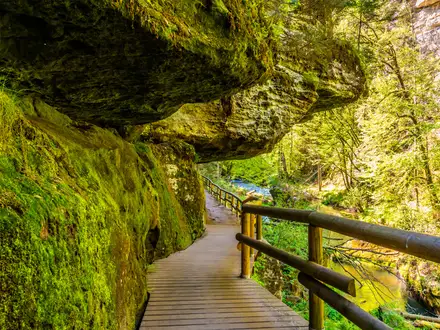
The Costa da Caparica Boardwalk is an easy 6 km coastal walk in Almada, Portugal, directly across the Tejo estuary from Lisbon. It suits families, casual walkers and beachgoers: the seafront section is flat promenade and wooden boardwalk, while the Mata dos Medos passadiços are signposted cliff-top circuits through coastal woodland. Plan it as a half-day to full-day walk, with no permits, negligible ascent and year-round access. For a longer Atlantic coast trek, compare the Fishermen’s Trail.
Route Overview
This is not a single strict point-to-point trail. The town walk starts around Costa da Caparica’s central beaches, including Praia do CDS, Praia do Paraíso and Praia do Norte, then follows the seafront south past urban and surf beaches; you can continue on open sand towards Fonte da Telha. The separate Mata dos Medos boardwalks start by the Centro de Interpretação da Mata dos Medos (CIMM) on the Estrada Florestal da Fonte da Telha and form three signposted circuits using viewpoints such as Miradouro da Arriba, Miradouro do Oceano and Miradouro da Raposa. Costa da Caparica is roughly 15–20 minutes from Lisbon by car or bus over the 25 de Abril Bridge. For another Portuguese boardwalk route, see the Paiva Walkways.
Fossil cliffs, dunes and Lisbon’s beach coast
Costa da Caparica’s coast is shaped by a fossil sea cliff formed in Miocene/Pliocene times, around 10 million years ago. Tectonic movement and the 1755 Lisbon earthquake helped leave the cliff stranded inland rather than actively cut by waves. In the 18th century, King D. João V ordered the planting of the Mata dos Medos pine wood to stop dunes burying farmland. The area became the Paisagem Protegida da Arriba Fóssil da Costa de Caparica in 1984, while the town developed from a fishing settlement into Lisbon’s main beach escape.
Notable highlights
- Fossil Cliff / Arriba Fóssil: A prominent fossil cliff of Miocene sedimentary strata rising about 70 m above the beach. It is notable because the sea has retreated, leaving the cliff no longer eroded by waves.
- Mata dos Medos botanical reserve: A stone-pine and mastic-tree woodland planted in the 18th century to halt advancing dunes. The raised boardwalks make this protected cliff-top habitat easy to explore on foot.
- Miradouro da Arriba, do Oceano and da Raposa: These cliff-top viewpoints look along the Costa da Caparica coastline, with reported views from Cabo Espichel towards the Tejo mouth and Serra de Sintra.
- String of Atlantic beaches: The seafront promenade links golden-sand beaches used for sea-bathing and surfing near Lisbon. The beaches were historically connected by the small Transpraia beach railway.
- Birdlife on the cliff: The eroded cliff faces provide nesting sites for birds of prey including kestrels, with goshawks and other raptors recorded in the protected landscape.
Challenges to expect
The walking is easy, but plan for exposure rather than altitude. Summer can be hot and busy because Costa da Caparica is Lisbon’s main beach escape, while winter is bracing but still walkable. Open sand south of the promenade is slower than boardwalk or pavement. Navigation is straightforward on the signposted Mata dos Medos circuits, but treat the route as a promenade plus boardwalk network, not one continuous waymarked thru-hike. For a longer pilgrimage-style route, see the Caminho Português.
HikeList Score
Costa da Caparica Boardwalk scored 71/100 on HikeList's trail-quality metrics.
See score breakdownHide breakdown
- Ideal length 55
- Balanced challenge 50
- Scenery & wildness 98
- Varied terrain 71
- Accommodation 66
- Food & support 81
- Path quality 80
- Season flexibility 63
Computed from length, challenge, scenery & wildness, terrain variety, accommodation, food & support, path quality and season flexibility.
 Portugal
Show more data Show less
- Coastal
- Forest
- Wooden Boardwalk
- Paved
- Sand
- Hotels
- Campsites
- Wheelchair Accessible
- Stroller Accessible
- Family Friendly
- Pet Friendly
- Restrooms
- Water Sources
- Picnic Areas
In these collections
Photos from hikers
Taken on the trail by people who've reviewed Costa da Caparica Boardwalk.
Reviews
How would you rate Costa da Caparica Boardwalk?
Tap a star to start your review — you could be the first.