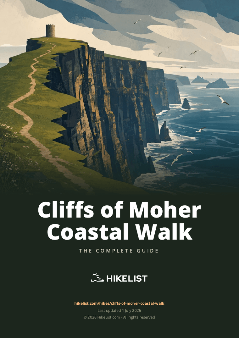
Cliffs of Moher Coastal Walk
How would you rate Cliffs of Moher Coastal Walk?
Tap a star to share your experience and help other hikers.
Cliffs of Moher Coastal Walk: Exposed Cliff-Top Hiking in County Clare
HikeList Score
Cliffs of Moher Coastal Walk scored 79/100 on HikeList's trail-quality metrics.
See score breakdownHide breakdown
- Ideal length 55
- Balanced challenge 100
- Scenery & wildness 71
- Varied terrain 89
- Accommodation 91
- Food & support 68
- Path quality 87
- Season flexibility 89
Computed from length, challenge, scenery & wildness, terrain variety, accommodation, food & support, path quality and season flexibility.
The Cliffs of Moher Coastal Walk is an 18 km point-to-point day hike on County Clare’s west coast, linking Doolin with Liscannor / Hag’s Head via the Cliffs of Moher Visitor Centre. It is a moderate route for fit walkers, but exposed cliff-edge terrain, mud, rock and Atlantic wind make it feel strenuous in places. Important: as of 2026 the full coastal walk is closed end-to-end for safety; only a short Doolin section to the Surfers’ Path is currently walkable.
Route Overview
The usual line runs north–south or south–north between Doolin Community Centre and Liscannor GAA / Hag’s Head, passing Fisher Street, Aillenasharragh / Surfers’ Path, the Cliffs of Moher Visitor Centre, O’Brien’s Tower and Branaunmore sea stack. Common shorter sections are Doolin to the Visitor Centre and the Visitor Centre to Hag’s Head, but these are affected by the current closures. This is a linear walk, so hikers normally need a bus, taxi or pre-arranged lift to avoid retracing the route. For other coastal walking ideas in Ireland, compare the Aran Islands Loop Trails, Dingle Way and Causeway Coast Way.
History of the Cliffs of Moher
The cliffs take their name from “Mothar”, an old promontory fort at Hag’s Head. It was demolished in 1808, with stone used for a signal tower during the Napoleonic wars. O’Brien’s Tower was added in 1835 by Sir Cornelius O’Brien as a lookout for visitors. The cliffs are formed mainly of Namurian shale and sandstone, and the coast has long been used for farming and lookout sites. Today it is a signature stop on the Wild Atlantic Way.
Notable highlights
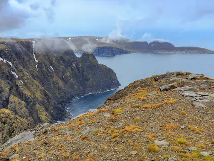
O’Brien’s Tower (214 m cliff high point): A round stone viewing tower built in 1835 by Sir Cornelius O’Brien. It stands near the highest part of the cliffs, with views towards the Aran Islands, Connemara and Galway Bay in clear weather.
Hag’s Head: The southern headland of the route, around 120 m above the sea. It is linked to local folklore and to the former promontory fort “Mothar”; the ruins of a later signal/lookout tower remain.
Cliffs of Moher Visitor Centre: The main facility on the route, built into the hillside near the midpoint. It has exhibits on geology, history and wildlife, plus café and toilets.
Seabird colonies: The cliffs are an Important Bird Area, with breeding seabirds including Atlantic puffins, razorbills, guillemots and kittiwakes. Spring and summer are the best viewing seasons.
Branaunmore sea stack: A 67 m sea stack below the cliffs near O’Brien’s Tower. It is a clear landmark and a visible reminder of ongoing coastal erosion.
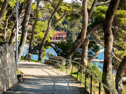
Doolin village: The northern trailhead is known for traditional music pubs and ferry links to the Aran Islands. It makes the most practical start or finish for walkers using services.
Challenges to expect
Expect exposed cliff-top walking with narrow rocky or muddy sections, grassy headlands, flagstone steps, farm tracks and some road walking. Many cliff-edge sections have few or no barriers, and west-coast weather can bring strong wind, rain and poor visibility at any time of year. The route crosses private farmland by agreement, dogs are not allowed, and the full trail is currently closed end-to-end for safety works.
HikeList Score
Cliffs of Moher Coastal Walk scored 79/100 on HikeList's trail-quality metrics.
See score breakdownHide breakdown
- Ideal length 55
- Balanced challenge 100
- Scenery & wildness 71
- Varied terrain 89
- Accommodation 91
- Food & support 68
- Path quality 87
- Season flexibility 89
Computed from length, challenge, scenery & wildness, terrain variety, accommodation, food & support, path quality and season flexibility.
Show more data Show less
- Coastal
- Cliff Top
- Grassland
- Dirt
- Grass
- Rock
- Flagstone
- Road
- B&Bs
- Hotels
- Hostels
- Family Friendly
- Restrooms
- Picnic Areas
Download Our Full Guide to Cliffs of Moher Coastal Walk FREE!
Get our comprehensive guide to this hike for free. Save it for later reading or print out at home.
In these collections
Photos from hikers
Taken on the trail by people who've reviewed Cliffs of Moher Coastal Walk.
Cliffs of Moher Coastal Walk: The Complete Guide
The Cliffs of Moher Coastal Walk is Ireland’s classic Atlantic cliff-top day walk, tracing the edge of County Clare between Doolin (Dúlainn) and Liscannor (Lios Ceannúir). It is a linear route of 19.5 km, with the most dramatic clifftop walking running for about 14 km between Doolin and Hag’s Head (Ceann na Cailleach).
The path passes the Cliffs of Moher Visitor Centre, climbs near O’Brien’s Tower and reaches the highest part of the cliffs at about 214 m. On clear days, the views stretch towards the Aran Islands, Connemara and Galway Bay, while seabirds circle the cliff faces below in spring and early summer.
This is not a casual promenade. The route is officially graded Strenuous because long sections are narrow, rough, muddy and very close to an unfenced cliff edge, with Atlantic wind and poor visibility capable of making conditions unsafe.
Good footwear, a head for heights and sensible weather judgement matter more here than fitness alone. Dogs are not allowed, children need close supervision, and the live closure status on cliffsofmoher.ie should be checked before travelling, as safety works have affected through-access on the route.
This guide covers route sections, accommodation bases, food and facilities, transport, terrain, safety and the common planning mistakes to avoid.
Stage-by-Stage Guide
Before planning the stages below, check the live closure notices on the official Cliffs of Moher website. As of early 2026, the full coastal walk is largely closed for safety works: the southern Liscannor/Hag's Head section is fully closed, and from Doolin walkers can only go as far as Surfers' Path before turning back, with no through-access to the Visitor Centre along the cliff path.
The route crosses private farmland by permissive agreement, so stay on the marked line and respect any closures or diversions. Dogs are not allowed on the walk.
Stage 1: Doolin (Dúlainn) to Cliffs of Moher Visitor Centre — approx. 8 km
This is the northern approach to the cliffs, leaving Doolin from the official start at Doolin Community Centre and heading out through the Fisher Street / Doolin Pier side of the village before joining the waymarked cliff path. The walking soon becomes fully coastal, with broad Atlantic views and a steadily more serious cliff-edge feel as the route climbs away from Doolin.
Under normal open-route conditions, this stage passes the Surfers' Path area at Aill na Searrach / Aillenasharragh and continues south towards the main Cliffs of Moher Visitor Centre. In the current early-2026 closure arrangement, Doolin access is only as far as Surfers' Path, where walkers must turn back.
The terrain is a mix of grassy and earthen headland path, rough ground and potentially muddy sections. The route is not a promenade: expect narrow walking close to an unfenced cliff edge, with Atlantic wind making exposed sections feel more serious than the modest ascent suggests.
The main landmark at the end of the stage is the Cliffs of Moher Visitor Centre, built into the hillside near the midpoint of the walk. It is the only staffed stop on the route and has toilets, a café and visitor facilities, making it the practical place to pause, use services or leave the cliff path if needed.
Food and water should still be carried from Doolin, as there are no intermediate services between the village and the Visitor Centre. Doolin has the most useful trailhead services for walkers, including accommodation, pubs and places to eat, but availability should be booked ahead in the busier walking season.
There is no accommodation on the cliff path at the Visitor Centre itself. If stopping here, the practical bases are Doolin to the north or Liscannor, Lahinch and Ennistymon to the south, reached by road transport.
For public transport and road access, the Visitor Centre is served by road and is on the Bus Éireann 350 coastal route between Ennis, Lahinch, Liscannor, the Cliffs of Moher, Doolin, Lisdoonvarna and Galway. Seasonal shuttle services also link Doolin, the Visitor Centre and Hag's Head / Liscannor, but current timetables should be checked before travelling.
Navigation is generally by the blue arrow on a white background. In poor visibility, do not drift towards the cliff edge to look for the path; stay on the marked route or turn back if the way ahead is unclear.
Key warnings for this stage are exposure, mud and proximity to the unprotected edge. It should not be walked in strong wind or poor visibility, and children need to be kept close throughout.
Stage 2: Cliffs of Moher Visitor Centre to Hag's Head (Ceann na Cailleach) / Moher Tower — approx. 6 km
This is the most dramatic central and southern cliff-top section, running from the Visitor Centre area past the highest part of the Cliffs of Moher and on towards Hag's Head. It includes the classic views around O'Brien's Tower and the sheer cliff line above Branaunmore sea stack.
The route reaches about 214 m just north of O'Brien's Tower, the highest point of both the cliffs and the walk. On clear days, views extend out towards the Aran Islands, Connemara and Galway Bay, while the cliffs below are an important seabird area, with puffins and other breeding seabirds most associated with spring and early summer.
The terrain remains rough, exposed and often narrow. Expect grassy and earthen path, rocky patches and flagstone sections, with the cliff edge close by in places and little shelter from wind or rain.
O'Brien's Tower is the key built landmark on this stage, standing near the highest part of the route. Branaunmore sea stack lies below the cliffs nearby, and the stage finishes at Hag's Head and Moher Tower, the ruined signal/lookout tower on the southern headland.
The Visitor Centre is the last reliable on-route food, water and toilet stop before the southern end. There are no staffed facilities on the cliff path between the Visitor Centre and Hag's Head, so carry enough water and food for the remainder of the walk.
There is no accommodation at Hag's Head or on the clifftop. If ending here, walkers normally continue or transfer towards Liscannor, Lahinch, Ennistymon or back to Doolin, depending on transport arrangements.
Road access is available near the southern end via the Hag's Head / Moher Sports Field side of the route, and seasonal shuttle services may serve the Hag's Head / Liscannor area. Bus Éireann 350 serves the wider coastal corridor, including Liscannor, the Cliffs of Moher and Doolin; check current times before relying on it.
Navigation is straightforward in clear weather if the waymarks and established path are followed, but this stage is not forgiving of poor judgement. Stay back from the edge, do not leave the marked route for photographs, and avoid the section entirely in strong wind, low cloud or heavy rain.
As of early 2026, the southern section between the Visitor Centre and Liscannor / Hag's Head is closed for safety works. Do not attempt to bypass barriers or continue along closed cliff-edge sections.
Stage 3: Hag's Head to Liscannor (Lios Ceannúir) — approx. 5.5 km
This final section leaves the scenic clifftop at Hag's Head and Moher Tower, then turns inland towards Liscannor. It is a less dramatic stage than the cliff-top walking, but it is important for completing the official Doolin-to-Liscannor route, which finishes at Liscannor GAA.
The terrain changes noticeably after Hag's Head. Expect lanes, farm tracks and quiet country road rather than continuous cliff path, with a more settled rural feel as the route drops towards the village.
Hag's Head itself stands around 120 m above the Atlantic and is the main highlight at the start of the stage. After that, the practical focus is the walk-out via Moher Sports Field car park and onward to Liscannor.
There are no guaranteed food or water stops between Hag's Head and Liscannor, so carry what is needed from the Visitor Centre or from the start of the day. Liscannor has village services at the end of the route, with further accommodation and food options in nearby Lahinch and Ennistymon.
Accommodation is not available on the path itself, but Liscannor, Lahinch and Ennistymon are the practical southern bases. Doolin remains the most convenient northern base, especially for walkers using shuttle services or combining the walk with ferries from Doolin Pier to the Aran Islands.
For transport, Liscannor is on the Bus Éireann 350 coastal route, which links Ennis, Lahinch, Liscannor, the Cliffs of Moher, Doolin, Lisdoonvarna and Galway. Seasonal shuttles and local taxis are also used to solve the point-to-point logistics, but times and availability should be checked before travelling.
Navigation is less exposed than on the cliff-top sections, but attention is still needed at lane junctions and where the route leaves the coast. Follow the blue arrows on a white background and avoid assuming that any road or farm track automatically leads to Liscannor.
The main warnings here are road walking, changeable weather after a long exposed day, and respecting private land. As of early 2026, this southern approach from Liscannor / Hag's Head is within the closed section of the coastal walk, so it should not be used until official reopening notices allow access.
Recommended Itinerary
Before planning around the table below, check the live closure notices on the official Cliffs of Moher website. The full coastal walk has been subject to major safety-work closures, with the southern Liscannor/Hag's Head section closed and Doolin access limited to Surfers' Path during early 2026. Do not assume there is through-access to the Visitor Centre or Hag's Head until current notices say so.
Standard itinerary: full Doolin to Liscannor walk
This is the normal end-to-end plan when the full route is open. It suits fit walkers who are comfortable with exposed, narrow cliff-top paths and who have return transport arranged in advance.
| Day | From | To | Approx. distance | Why this stage makes sense | Services/accommodation notes |
|---|---|---|---|---|---|
| 1 | Doolin (Dúlainn) | Cliffs of Moher Visitor Centre | 8 km | A logical northern start from the official trailhead, with the path building gradually towards the main cliff viewpoints. Starting here puts the Visitor Centre roughly mid-walk, giving a useful break point before the southern cliffs. | Doolin has accommodation, pubs and services before the walk. The Visitor Centre is the main staffed facility on the route, with toilets and a café. |
| 1 | Cliffs of Moher Visitor Centre | Hag's Head (Ceann na Cailleach) / Moher Tower | 6 km | This is the core high-cliff section south of the Visitor Centre, passing the most dramatic cliff scenery and continuing towards the southern headland. It is still exposed and requires full cliff-edge caution. | No accommodation on the cliff path. Hag's Head has no full village services, so return transport or onward walking to Liscannor must already be planned. |
| 1 | Hag's Head | Liscannor (Lios Ceannúir) | 5.5 km | This completes the official point-to-point route, leaving the scenic cliff-top section and following lanes and country road down to the official finish at Liscannor GAA. | Liscannor has end-of-walk services and accommodation options. Lahinch and Ennistymon are also practical south-end bases. Use the seasonal shuttle, Bus Éireann 350, taxi or an arranged lift for the return. |
Slower variant: Doolin to Hag's Head only
This option suits walkers who want the main cliff-top experience without adding the final road-and-lane section into Liscannor. It is still a serious exposed walk, not an easy stroll.
| Day | From | To | Approx. distance | Why this stage makes sense | Services/accommodation notes |
|---|---|---|---|---|---|
| 1 | Doolin (Dúlainn) | Hag's Head (Ceann na Cailleach) / Moher Tower | About 14 km | This covers the scenic cliff-top section from Doolin past the Visitor Centre to the southern headland, while omitting the final 5.5 km into Liscannor. It gives more time for breaks and weather delays than the full 19.5 km route. | Doolin is the most practical base. Arrange pickup, taxi, seasonal shuttle or other return transport from the Hag's Head/Liscannor area before setting out; timetables should be checked before travelling. |
Faster variant: full route in one continuous push
Fast, experienced walkers may treat the route as a single continuous day walk from Doolin to Liscannor, stopping only briefly at the Visitor Centre or O'Brien's Tower. This is only sensible in good visibility, moderate wind and with secure footing underfoot.
| Day | From | To | Approx. distance | Why this stage makes sense | Services/accommodation notes |
|---|---|---|---|---|---|
| 1 | Doolin (Dúlainn) | Liscannor (Lios Ceannúir) | 19.5 km | This follows the official end-to-end route in one day and avoids needing to break the walk into shorter sections. It works best for walkers already comfortable moving efficiently on rough, muddy and exposed coastal paths. | Carry what is needed between Doolin and the Visitor Centre, then between the Visitor Centre and Liscannor. There is no on-route lodging, and return transport must be arranged because the route is linear. |
Planning the Route
Check the live route status first
Do this before arranging any transport or accommodation. As of early 2026, the full Cliffs of Moher Coastal Walk is largely closed for safety works: the southern section between Liscannor / Hag's Head and the Visitor Centre is fully closed, and from Doolin walkers can only go as far as Surfers' Path before turning back.
There is no through-access to the Cliffs of Moher Visitor Centre along the cliff path while these closures are in place. Check the official Cliffs of Moher closure notices on cliffsofmoher.ie before travelling, and only plan the full end-to-end walk when the route is open.
How much time to allow
When fully open, this is best planned as a single-day linear walk, not a multi-day route. The official walking time is around 4.5 to 5 hours for Doolin to Liscannor, but most walkers should allow a full day once transport, weather delays, the Visitor Centre, viewpoints and cautious walking near the cliff edge are included.
It is not a route to rush. The path is often narrow, muddy and close to an unfenced drop, so progress can be slower than the distance suggests, especially in wind, after rain or where walkers are passing each other on confined sections.
Natural sections of the walk
The route has no accommodation-based stages, but it does break naturally into three planning sections. These are useful for deciding where to stop, shorten the walk or arrange transport.
| Section | Approx. distance | Planning notes |
|---|---|---|
| Doolin (Dúlainn) to Cliffs of Moher Visitor Centre | 8 km | Northern clifftop approach from Doolin, passing Fisher Street / Doolin Pier area and Surfers' Path. When closures apply, this section may only be open as far as Surfers' Path. |
| Visitor Centre to Hag's Head / Moher Tower | 6 km | The main high-cliff section, passing near O'Brien's Tower and the highest part of the cliffs. Fully exposed and not suitable in strong wind or poor visibility. |
| Hag's Head to Liscannor (Lios Ceannúir) | 5.5 km | Leaves the most dramatic clifftop section and continues by lanes and country road towards Liscannor GAA. |
The most scenic clifftop walking is between Doolin and Hag's Head, about 14 km. The final section into Liscannor is useful for completing the official route, but it is more logistical and road-based than the cliff-edge section.
Shortening, section hiking and extensions
Section hiking is practical when the path is open because Doolin, the Cliffs of Moher Visitor Centre, Hag's Head / Liscannor and nearby settlements are linked by road transport. The seasonal shuttle and Bus Éireann route 350 are the key services to check, alongside local taxis.
Common shorter plans include walking from Doolin to the Visitor Centre, from the Visitor Centre to Hag's Head, or the clifftop-only Doolin to Hag's Head section. Exact start and finish logistics should be matched to current closures, shuttle stops, bus times and available parking before setting out.
There is no natural long-distance continuation described as part of this route. Ferries from Doolin Pier to the Aran Islands can make a separate trip, but they are not an extension of the coastal walk itself.
Accommodation planning
Accommodation is not needed on the route itself. Plan one or two nights at a base instead, depending on travel time and transport connections.
Doolin is the most practical base for many walkers because it sits at the northern trailhead and has hostels, B&Bs, guesthouses, pubs and some hotel accommodation. At the southern end, Liscannor, Lahinch and Ennistymon offer further hotels, guesthouses, B&Bs and hostels.
Because this is a popular Wild Atlantic Way area, accommodation should be booked ahead in the main walking season. Current prices and availability should be checked before booking.
Food, water and facilities
The Cliffs of Moher Visitor Centre is the main facility on the route, with a café, toilets and exhibits. Treat it as the only staffed stop on the walk, and check opening times before relying on it.
Carry enough water and food for the full walk, especially if starting early, walking outside peak season, or using a shortened route that does not pass through the Visitor Centre. There are no on-route lodging or resupply stops along the cliff path itself.
Transport is the main logistical issue
This is a point-to-point walk, so return transport must be planned before setting off. There is no railway serving the route.
Bus Éireann route 350 runs along the coast between Ennis, Lahinch, Liscannor, the Cliffs of Moher, Doolin, Lisdoonvarna and Galway. A seasonal shuttle also links Doolin, the Visitor Centre and Hag's Head / Liscannor, and taxis operate in the area.
Do not assume late-day transport will be available without checking. Verify the current Bus Éireann 350 timetable, seasonal shuttle operation and taxi options before travelling, particularly outside summer or if planning to finish at Hag's Head rather than in Liscannor.
Navigation and access
When open, the route is waymarked with a blue arrow on a white background. The official route runs from Doolin Community Centre to Liscannor GAA, with the cliff path leaving Doolin near Fisher Street and the harbour area.
The official Cliffs of Moher route map and mobile app are useful planning tools, and OSi Discovery Series sheets 51 and 57 cover the area. Navigation is generally straightforward in clear weather, but poor visibility beside an unfenced cliff edge is a serious safety issue rather than just a route-finding inconvenience.
The walk crosses private farmland by permissive agreement. Keep to the marked path, respect any closures or diversions, and note that dogs are not allowed.
Weather planning
Weather is more important here than distance or ascent. The route is fully exposed to Atlantic wind and rain, and much of the path runs close to an unprotected cliff edge.
Do not start in strong wind, poor visibility or conditions that make the ground slippery and unsafe. If conditions deteriorate, turn back or leave the route at a safe access point rather than pressing on to complete the distance.
Towns, Villages and Overnight Stops
This is a one-day linear walk, not a hut-to-hut route. There is no overnight accommodation on the cliff path itself, so walkers normally stay at one of the trailhead villages or in a nearby south-coast base and use a bus, shuttle, taxi or arranged lift to handle the point-to-point logistics.
Before booking around a full Doolin-to-Liscannor traverse, check the live closure notices on the official Cliffs of Moher website. As of early 2026, the full coastal walk is largely closed for safety works, with the southern Liscannor/Hag’s Head section closed and access from Doolin limited to Surfers’ Path before turning back.
| Place | Position on the route | Overnight usefulness | Key hiker notes |
|---|---|---|---|
| Doolin (Dúlainn) | Northern trailhead | Best all-round base | Accommodation, pubs, road access, Bus Éireann 350, seasonal shuttle, Aran Islands ferries from Doolin Pier |
| Fisher Street / Doolin Pier | Leaving Doolin | Part of Doolin rather than a separate base | Useful for orientation; ferry port area below the start of the cliff approach |
| Surfers’ Path | North section | No accommodation | Current northern access limit during closures; turn back if closure notices require it |
| Cliffs of Moher Visitor Centre | Near midpoint | No lodging | Café and toilets; the only staffed facility directly on the walk |
| Hag’s Head / Moher Tower | End of the main scenic cliff section | No accommodation on the headland | Southern cliff landmark; access and closures must be checked before travelling |
| Liscannor (Lios Ceannúir) | Official southern finish | Practical south-end finish/base | Accommodation in and around the village; Bus Éireann 350 serves the coast |
| Lahinch (An Leacht) | Near the south end, off-route | Good alternative base | More useful for walkers wanting a south-coast base with onward road/bus connections |
| Ennistymon (Inis Díomáin) | Inland market town near the south end | Good alternative base | Works well if accommodation in the trailhead villages is full |
Doolin (Dúlainn)
Doolin is the northern trailhead and the most practical base for most walkers, especially when using the seasonal shuttle, Bus Éireann 350 or Doolin Pier ferries. The official start is at Doolin Community Centre, with the waymarked cliff path leaving the village near Fisher Street and the harbour above Doolin Pier.
Accommodation is the strongest here among the route-end options, with hostels, guesthouses, B&Bs and a couple of hotels. Doolin is also known for traditional-music pubs, making it the most convenient place to stay the night before an early start or after walking the route northbound.
For food and supplies, do not rely on the cliff path itself. Eat before setting out, carry water and snacks, and check current opening hours locally, particularly outside the main visitor season.
Transport is by road only; there is no railway on the route. Bus Éireann route 350 serves Doolin on the coastal corridor between Ennis, Lahinch, Liscannor, the Cliffs of Moher and Galway, and seasonal shuttle services link Doolin with the Visitor Centre and Hag’s Head/Liscannor when operating. Timetables should be checked before travelling.
Fisher Street / Doolin Pier
Fisher Street and Doolin Pier are useful orientation points rather than separate overnight stops. The cliff route leaves the village area near Fisher Street and the harbour, climbing out above Doolin Pier, which is the ferry port for the Aran Islands.
This is a practical area for walkers combining the coastal walk with ferry travel, but ferry trips are separate from the walking route. Allow enough time between ferries, buses and walking plans, as this is a linear route and return transport needs to be arranged deliberately.
Surfers’ Path (Aill na Searrach / Aillenasharragh)
Surfers’ Path is on the northern section between Doolin and the main Cliffs of Moher area. It is not an overnight stop and should be treated as a route point rather than a service location.
During the current closure period, walkers from Doolin can only reach Surfers’ Path before turning back, with no through-access to the Visitor Centre along the cliff path. Check the official closure notices before setting out and do not continue past closed sections.
Cliffs of Moher Visitor Centre
The Cliffs of Moher Visitor Centre sits near the midpoint of the walk and is the main staffed facility on the route. It has exhibits, a café and toilets, making it the obvious place to pause, use facilities and reassess weather before continuing.
There is no overnight accommodation at the Visitor Centre. It works as a transport and turnaround point for walkers doing a shorter section, particularly when using the seasonal shuttle or Bus Éireann 350.
Do not treat the Visitor Centre as a guarantee that the full walk is open. The cliff path north and south of it is subject to safety closures, and current access should be checked on the official Cliffs of Moher website before travelling.
O’Brien’s Tower and Branaunmore Sea Stack
O’Brien’s Tower is a landmark near the highest part of the cliffs, close to the 214 m high point just north of the tower. Branaunmore sea stack is below the cliffs in this area and is a visual landmark, not a stopping place with services.
There is no accommodation, food shop or hiker facility at these points beyond what is available back at the Visitor Centre area. Use this section for views only, keep moving if weather worsens, and stay on the marked path away from the unfenced cliff edge.
Hag’s Head (Ceann na Cailleach) / Moher Tower
Hag’s Head marks the southern end of the main scenic clifftop section, with Moher Tower on the headland. It is a major route landmark, but not an overnight stop and not a place to rely on for food or facilities.
From Hag’s Head the official route continues by lanes and country road towards Liscannor. This final section is less dramatic than the clifftop path but still matters logistically, as the official finish is in Liscannor rather than at the headland.
The southern section from Liscannor/Hag’s Head to the Visitor Centre is closed during the current safety-works period. Check live notices before arranging a drop-off, pick-up or accommodation based on walking through this section.
Moher Sports Field car park
Moher Sports Field car park is a useful southern access point near the Hag’s Head end of the route. It is a parking/access location rather than a village and has no overnight accommodation.
If using it for a shortened walk or pick-up, confirm current access, parking arrangements and the status of the southern cliff section before travelling. Do not assume the path onwards is open during closure periods.
Liscannor (Lios Ceannúir)
Liscannor is the official southern finish, with the route ending at Liscannor GAA after the lane and road section from Hag’s Head. It is the natural south-end village for walkers completing the full route when the path is open.
Accommodation is available in the south-end area, with hotels, guesthouses, B&Bs and hostels found in Liscannor and nearby bases such as Lahinch and Ennistymon. Liscannor is practical for finishing the walk, but Doolin is generally the easier base for walkers prioritising shuttle and ferry connections.
Bus Éireann route 350 serves the coastal corridor through Liscannor, linking it with Lahinch, the Cliffs of Moher, Doolin, Ennis and Galway. Check the current timetable before relying on it for the return leg, especially if finishing late in the day.
Lahinch (An Leacht)
Lahinch is an off-route south-coast base near Liscannor. It is useful if accommodation at the route ends is full, or if a walker wants a broader south-end base before or after the walk.
The town is served by the same coastal transport corridor as Liscannor, with Bus Éireann 350 linking Lahinch with Liscannor, the Cliffs of Moher, Doolin, Ennis and Galway. Timetables and last services should be checked before booking a one-way walk.
Ennistymon (Inis Díomáin)
Ennistymon is an inland market town near the southern end of the route and works as another accommodation fallback for the Liscannor/Lahinch side. It is not on the cliff path, so staying here means arranging road transport to or from the walk.
Use Ennistymon as a practical base only if the transport plan is clear. For an end-to-end walk, confirm how to reach Doolin or Liscannor in the morning and how to return after finishing, using the current Bus Éireann 350 timetable, a taxi or an arranged lift.
Getting to the Start
Before arranging transport, check the current Cliffs of Moher Coastal Walk status on the official Cliffs of Moher website. As of early 2026, the full route is largely closed for safety works: the southern Liscannor/Hag’s Head section is closed, and from Doolin walkers can only go as far as Surfers’ Path before turning back, with no through-access to the Visitor Centre along the cliff path.
The official northern start is at Doolin Community Centre in Doolin (Dúlainn), County Clare. From the village, the waymarked cliff path leaves near Fisher Street and the harbour area above Doolin Pier.
By train
There is no railway station on the route and no train service to Doolin or Liscannor. Rail travellers need to connect with onward road transport, normally by bus or taxi from a larger town on the regional transport network.
For public transport planning, the key onward link is Bus Éireann route 350, which serves the coast between Ennis, Lahinch, Liscannor, the Cliffs of Moher, Doolin, Lisdoonvarna and Galway. Train-to-bus connections, station choices and same-day timings should be checked before travelling.
By bus
Bus Éireann route 350 is the main public transport option for reaching Doolin. It runs along the coast via Ennis, Lahinch, Liscannor, the Cliffs of Moher, Doolin, Lisdoonvarna and Galway, making it useful both for getting to the start and for returning after a point-to-point walk.
A seasonal shuttle also links Doolin, the Cliffs of Moher Visitor Centre and Hag’s Head/Liscannor. This is particularly useful for walkers who want to park at one end, walk in one direction and return without retracing the route.
Timetables, operating seasons and the latest route arrangements should be checked before travelling. This is especially important because the walk is linear, exposed and currently affected by closures, so missing the final bus or shuttle can leave a long road transfer by taxi.
By car
Doolin is reached by road and is the most practical northern base for the walk. The official start is at Doolin Community Centre, with the walking route leaving the village towards Fisher Street and the harbour area above Doolin Pier.
Because this is a point-to-point route, driving to the start does not solve the return journey. Many walkers park at one end and use Bus Éireann 350, the seasonal shuttle or a taxi to return from Liscannor, Hag’s Head or the Cliffs of Moher Visitor Centre, depending on the section being walked and the current open/closed status.
Parking locations, long-stay rules and any charges in Doolin, at the Visitor Centre, Hag’s Head/Moher Sports Field or Liscannor should be checked before travelling. Do not assume that a car can be left all day or that a shuttle will be running when you finish.
From the nearest airport
No airport sits close to the trailhead, so airport access involves an onward road journey to County Clare. The practical approach is to travel onwards to a transport hub served by Bus Éireann route 350, such as Ennis or Galway, then continue by bus or taxi to Doolin.
Airport-to-trailhead transfers, late arrivals and same-day walking plans need careful checking against current bus and shuttle timetables. If arriving late in the day, staying in Doolin before starting is usually the safer logistical choice.
Where to stay before starting
Doolin (Dúlainn) is the most practical place to stay before starting from the northern end. It has hostels, guesthouses, B&Bs, a couple of hotels and traditional-music pubs, and it is the easiest base for walkers using the shuttle, local taxis or the coastal bus.
At the southern end, Liscannor (Lios Ceannúir), Lahinch (An Leacht) and Ennistymon (Inis Díomáin) also have accommodation options and can work well if walking in the opposite direction or arranging a morning transfer to Doolin. There is no accommodation on the cliff path itself.
Book accommodation with transport in mind: the route is linear, dogs are not allowed, and current closures may affect where you can actually start or finish. Check live trail notices, wind conditions and return transport before committing to a walking day.
Getting Home from the Finish
The official finish is at Liscannor GAA in Liscannor (Lios Ceannúir). The scenic cliff-top walking ends earlier at Hag's Head (Ceann na Cailleach) and Moher Tower, after which the route follows lanes and country road down into the village.
Before planning any end-to-end transport, check the live trail status on the official Cliffs of Moher website. As of early 2026 the full coastal walk is largely closed for safety works, with the southern Liscannor/Hag's Head section closed and no through-access from Doolin to the Visitor Centre along the cliff path.
By train
There is no railway serving Doolin, the Cliffs of Moher, Hag's Head or Liscannor. Any rail-based journey needs a road connection first, normally by bus or taxi to a larger town.
For onward public transport, use Bus Éireann route 350 to reach places on the coastal corridor such as Ennis or Galway, then connect as required. Timetables and connections should be checked before travelling, especially if finishing late in the day.
By bus
Bus Éireann route 350 is the key public transport option from the finish area. It runs along the coast between Ennis, Lahinch, Liscannor, the Cliffs of Moher, Doolin, Lisdoonvarna and Galway, making it useful both for returning to Doolin and for onward travel to larger towns.
For many walkers, the simplest plan is to park or stay at one end, walk the route, then use route 350 back along the coast. If returning to Doolin after finishing in Liscannor, check the current 350 timetable carefully and do not assume there will be a convenient late service.
A seasonal shuttle also links Doolin, the Cliffs of Moher Visitor Centre and Hag's Head/Liscannor. This can be very useful for walkers ending at Hag's Head rather than continuing all the way into Liscannor, but it is season- and timetable-dependent. Current operating dates, pick-up points and times should be checked before travelling.
By car/taxi
Because this is a linear walk, car logistics need deciding before setting out. Common options are to leave a vehicle near the finish and travel to the start before walking, or to start from Doolin and return from Liscannor by bus, shuttle or taxi.
Taxis serve the area and are the most flexible option if bus times do not work, if the weather forces an early exit, or if finishing late. Pre-booking is strongly recommended, particularly outside the main visitor season or at the end of the day.
If arranging a taxi pick-up, be clear whether the collection point is Liscannor village, Liscannor GAA, Hag's Head, Moher Sports Field car park or the Cliffs of Moher Visitor Centre. These are not interchangeable when tired walkers are waiting at the end of the route.
From the nearest airport
There is no airport at the finish and no direct airport transfer should be assumed from Liscannor. Plan airport journeys via the regional bus network and larger transport hubs such as Ennis or Galway, using route 350 for the coastal section where suitable.
Airport transfer times, onward bus connections and late-day options are timetable-dependent. This should be checked before travelling.
Where to stay at the finish
Liscannor has accommodation options close to the official finish, and the nearby south-end bases of Lahinch (An Leacht) and Ennistymon (Inis Díomáin) offer more places to stay, including hotels, guesthouses, B&Bs and hostels. These are practical choices if finishing late, if bus connections do not line up, or if continuing travel the following morning is easier.
Doolin remains the most practical base for many walkers using the shuttle or coastal bus, especially when planning a same-day return. If the goal is to avoid rushed transport after the walk, staying around Liscannor, Lahinch or Ennistymon at the southern end is usually the safer plan.
Which Direction Should You Walk?
Before planning either direction, check the live Cliffs of Moher closure notices. As of early 2026, the full coastal walk is largely closed for safety works: the southern Liscannor/Hag’s Head to Visitor Centre section is closed, and from Doolin walkers can only go as far as Surfers’ Path before turning back. Do not plan an end-to-end walk until through-access is open again.
Standard direction: Doolin to Liscannor
The official and most natural direction is north to south, starting at Doolin Community Centre and finishing at Liscannor GAA. This is also the simplest direction to understand on the ground: Doolin, Fisher Street and Doolin Pier lead into the cliff path, then the route passes the Cliffs of Moher Visitor Centre, O’Brien’s Tower, Hag’s Head and finally the lanes into Liscannor.
Doolin is the most practical base for many walkers, with accommodation, pubs, hostels, guesthouses and access to the seasonal shuttle and Aran Islands ferries from Doolin Pier. If staying in Doolin, walking south and returning by shuttle, Bus Éireann 350 or taxi is a straightforward plan, but current timetables should be checked before travelling.
Scenically, Doolin to Liscannor works well. The cliffs build gradually from the northern approach towards the highest ground near O’Brien’s Tower, then continue to the open southern headland at Hag’s Head and Moher Tower. The final 5.5 km from Hag’s Head to Liscannor is less dramatic than the cliff-top section, using lanes and country road, so some walkers arrange transport from Hag’s Head or Moher Sports Field car park rather than continuing into the village.
Reverse direction: Liscannor to Doolin
Walking south to north is entirely logical if accommodation, parking or return transport works better from Liscannor, Lahinch or Ennistymon. It also gives a more satisfying practical finish for some walkers, because Doolin has more walker-friendly services at the end of the day.
The main drawback is that the reverse route begins with the road-and-lane section from Liscannor towards Hag’s Head before reaching the most dramatic cliff-top walking. For walkers who want the strongest scenery from the start, Doolin is the better trailhead.
The climbing difference is not a major factor either way. The route is undulating rather than a mountain ascent, with about 250 m of total ascent and the high point just north of O’Brien’s Tower. Direction choice should be based more on safety, transport and weather than on gradient.
Wind and weather
This is a fully exposed Atlantic cliff walk, and wind direction can matter more than route tradition. A strong headwind can make progress tiring; a strong crosswind near an unfenced cliff edge can make the route unsafe. In strong wind, poor visibility or heavy rain, do not treat a change of direction as a solution — postpone the walk.
On marginal but acceptable days, choose the direction that gives the safest and most manageable wind angle, then keep well back from the edge and stay on the marked path. This should be checked before travelling, using a current local forecast.
Recommendation
When the full route is open, Doolin to Liscannor is the best default direction: it follows the official line, starts from the most practical walker base and gives a strong scenic progression through the Visitor Centre, O’Brien’s Tower and Hag’s Head. Reverse it only if accommodation, parking or return transport works clearly better from the south, or if the day’s wind forecast makes the northbound option safer.
Accommodation Along the Route
This is a one-day linear walk, so accommodation planning is about choosing a practical base rather than finding beds along the trail. There is no lodging on the cliff path itself between Doolin (Dúlainn), the Cliffs of Moher Visitor Centre, Hag's Head (Ceann na Cailleach) and Liscannor (Lios Ceannúir).
Most walkers stay at one end of the route and use a shuttle, Bus Éireann 350 or a taxi to solve the point-to-point logistics. Doolin is usually the most convenient base for walkers, especially if combining the walk with the Doolin Pier ferries to the Aran Islands or using the seasonal Doolin–Visitor Centre–Hag's Head/Liscannor shuttle.
As of early 2026, the full coastal walk is largely closed for safety works, with no through access to the Visitor Centre from Doolin along the cliff path and the southern Liscannor/Hag's Head section closed. Check live closure notices on the official Cliffs of Moher website before booking accommodation around a through-walk plan.
| Place | Accommodation level | Best for | Notes |
|---|---|---|---|
| Doolin (Dúlainn) | Good | Starting at the northern trailhead; walkers using shuttles, taxis or ferries | The most practical walking base, with hostels, guesthouses, B&Bs, traditional-music pubs and a couple of hotels. Useful if beginning at Doolin Community Centre or near Fisher Street/Doolin Pier. |
| Liscannor (Lios Ceannúir) | Good | Finishing at the southern end; access to Hag's Head/Liscannor logistics | Has hotels, guesthouses and B&Bs. The official finish is at Liscannor GAA, with the scenic clifftop section ending earlier at Hag's Head before lanes and road into the village. |
| Lahinch (An Leacht) | Good | A south-end base with more visitor services nearby | A practical alternative to Liscannor, with hotels, guesthouses, B&Bs and hostels. Works best if transport is arranged to or from the trailheads. |
| Ennistymon (Inis Díomáin) | Good | Staying slightly inland with access by road to the coast | A market town option with hotels, guesthouses, B&Bs and hostels. Plan onward transport carefully, as the walk itself is on the coast and there is no railway serving the route. |
| Cliffs of Moher Visitor Centre | None | Mid-walk facilities only | The main staffed stop on the route, with café and toilets, but no walker accommodation. Do not plan this as an overnight halt. |
| Hag's Head / Moher Tower | None | Scenic endpoint of the clifftop section | No on-trail lodging. Walkers normally continue to Liscannor, use arranged transport, or link with the seasonal shuttle when operating. |
Best places to stay
Doolin is the strongest choice for a straightforward walking base. It sits at the northern trailhead, has the broadest walker-friendly feel, and is well placed for anyone relying on local shuttle services, taxis or the Bus Éireann 350 coastal route.
Liscannor is the obvious south-end option if the plan is to finish the official route and stay close to the end point. It is also useful for walkers intending to start at the southern end, though current trail closures must be checked before making that plan.
Lahinch and Ennistymon suit walkers who want a wider south County Clare base rather than staying directly at a trailhead. They can work well for a two-night stay if transport to and from the walk is arranged in advance.
Booking ahead
Accommodation pressure is highest in the main visitor season, particularly from late spring to early autumn, at weekends and around good-weather periods on the Wild Atlantic Way. Doolin is popular with walkers, music visitors and ferry passengers, so booking ahead is sensible rather than relying on same-day availability.
Prices, minimum stays and availability vary by season and property. Confirm current rates, cancellation terms and check-in times before booking, especially if the walking plan depends on a shuttle or taxi connection.
Inn-to-inn and luggage logistics
This route does not really function as an inn-to-inn walk. The full official route is only 19.5 km and is designed as a single day walk, with no overnight stops on the cliff path.
Luggage transfer is usually unnecessary for the walk itself. If moving between Doolin and Liscannor, Lahinch or Ennistymon, a taxi transfer can solve bags and end-to-end transport more simply than carrying overnight kit along the exposed cliff path.
Because the route is linear and no railway serves the trailheads, accommodation should be booked together with the return-transport plan. Verify the seasonal shuttle, Bus Éireann 350 timetable and any taxi arrangements before relying on them.
Camping and Wild Camping
This is a one-day coastal walk, not a route that suits camping. There is no on-route lodging or designated camping on the cliff path, and the walk crosses private farmland by permissive agreement, so pitching a tent beside the trail is not appropriate without explicit local permission.
As of early 2026, the full coastal walk is also largely closed for safety works. The southern Liscannor/Hag’s Head section is closed, and from Doolin walkers can only go as far as Surfers’ Path before turning back. Check live closure notices on cliffsofmoher.ie before making any walking or camping plans.
Campsites and overnight bases
For most walkers, the practical approach is to stay in Doolin (Dúlainn), Liscannor (Lios Ceannúir), Lahinch (An Leacht) or Ennistymon (Inis Díomáin), then walk the route as a day hike using a shuttle, Bus Éireann route 350 or a taxi for the return. These places have the accommodation infrastructure needed for the walk, including B&Bs, guesthouses, hostels and some hotels.
If camping is preferred, use a lawful campsite in the wider trailhead area rather than trying to camp on the cliffs. Campsite locations, seasonal opening dates and whether they accept tents should be checked before travelling.
Wild camping on the cliff path
Wild camping is a poor fit for the Cliffs of Moher Coastal Walk. The route is narrow, exposed to Atlantic wind and rain, frequently muddy, and in places runs within a few feet of an unfenced cliff edge. A tent on the clifftop would be vulnerable to wind, unsafe in poor visibility and likely to obstruct or damage land managed under permissive access.
The trail also passes through sensitive coastal farmland and near important seabird habitat. Do not camp in fields, beside the cliff edge, near O’Brien’s Tower, around the Cliffs of Moher Visitor Centre, at Hag’s Head, or on the approach lanes into Liscannor unless specific permission has been granted by the landowner or site manager.
Water, toilets and cooking
There is no reliable natural water supply on the clifftop route. Carry enough water from Doolin, Liscannor or wherever the walk is started. The Cliffs of Moher Visitor Centre is the main staffed facility on the route, with café and toilets, but opening times and access should be checked before relying on it.
Open fires are not appropriate on this route. The cliff tops are exposed, grassy, used for farming access and close to sensitive wildlife areas. Any cooking should only be done where camping is legally permitted, on a managed campsite or with clear permission.
Leave No Trace and seasonal concerns
Keep strictly to the marked path, take all litter away, and avoid disturbing livestock, nesting birds or vegetation. Dogs are not allowed on the walk, which also reflects the sensitivity of the farmland and cliff environment.
In spring and early summer, seabirds including puffins, razorbills, guillemots and kittiwakes breed on and around the cliffs. Give nesting areas space, keep noise low, and never approach cliff edges for photographs or camping spots.
Food, Water and Resupply
This is a one-day linear walk, so there is no real resupply strategy: start with what you need, use the Cliffs of Moher Visitor Centre only if it is open and accessible, and finish in Doolin (Dúlainn) or Liscannor (Lios Ceannúir) with onward food and transport already planned.
As of early 2026, the full coastal walk is largely closed for safety works, with no through-access from Doolin to the Visitor Centre along the cliff path and the southern section closed. Check the live closure notices on cliffsofmoher.ie before travelling, as this directly affects where food, toilets and water can be reached on foot.
Where food is available
Doolin is the most useful place to start with provisions. It has pubs and accommodation, but do not assume an early-morning food stop will be open before you begin; buy snacks and lunch in advance if starting early or walking outside the main visitor season.
The Cliffs of Moher Visitor Centre is the main on-route facility, with a café and toilets near the midpoint of the full route. Treat it as a useful stop, not as essential support: opening hours, access and current trail closures should be checked before planning your lunch around it.
South of the Visitor Centre, the clifftop section towards Hag’s Head has no reliable food stop on the path. After Hag’s Head, the route follows lanes and country road towards Liscannor; plan to finish there rather than depend on finding food immediately at the cliff exit.
Water planning
Carry enough water from the start to complete the walk without needing a refill. For the full 19.5 km route, most walkers should start with at least 1.5–2 litres, and more in warm weather or if walking slowly with children.
The Visitor Centre café and toilets are the only clear mid-route facility, but do not rely on a free bottle-fill point unless checked in advance. There are no dependable natural drinking-water sources on the clifftop route; field runoff, puddles, troughs or small drains should not be treated as normal water sources on this walk.
The route is fully exposed to Atlantic wind and weather, so dehydration can be easy to overlook on cool, windy days. Drink steadily rather than waiting until the Visitor Centre or the finish.
| Section | Food availability | Water availability | Notes |
|---|---|---|---|
| Doolin (Dúlainn) to Cliffs of Moher Visitor Centre | Food before departure in Doolin if services are open; café at the Visitor Centre when open and accessible | Start with full bottles; possible drinks/facilities at the Visitor Centre, but check current access and opening hours | About 8 km on the full route. As of early 2026, walkers from Doolin can only reach Surfers’ Path before turning back, with no through-access to the Visitor Centre along the cliff path. |
| Cliffs of Moher Visitor Centre to Hag’s Head | Café at the Visitor Centre before leaving; no reliable food stop on the clifftop section | Fill or buy drinks at the Visitor Centre if available; no dependable natural water on the cliff path | About 6 km. Exposed, narrow and close to the cliff edge, so choose safe, set-back places for snack stops. |
| Hag’s Head to Liscannor (Lios Ceannúir) | No on-path food service to rely on; plan to eat after reaching Liscannor or your onward base | Carry enough water from the Visitor Centre or start; do not expect a refill on this final road-and-lane section | About 5.5 km. This southern section is fully closed as of early 2026, so check official closure notices before planning it. |
What to carry
Pack lunch or substantial snacks even if intending to use the Visitor Centre café. Weather delays, closures, seasonal hours and transport timing can turn a short coastal walk into a much longer day.
A practical food carry for the full route is a packed lunch plus quick snacks that can be eaten without unpacking near the cliff edge. Keep food and water accessible, but only stop well back from the edge and away from narrow passing points.
Small-village and rural opening times can vary, especially on Sundays, evenings and outside the main visitor season. Check current café, pub, shop and transport times before travelling rather than assuming food will be available at the start or finish.
Terrain, Conditions and Difficulty in Practice
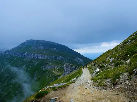
The Cliffs of Moher Coastal Walk is officially graded Strenuous, despite having only modest total ascent. The difficulty comes from exposure, narrow cliff-edge walking, rough ground, mud and Atlantic weather rather than from long climbs.
As of early 2026, the full coastal walk is largely closed for safety works: the southern Liscannor / Hag's Head section is fully closed, and from Doolin walkers can only go as far as Surfers' Path before turning back. Check the live closure notices on cliffsofmoher.ie before travelling, and do not attempt closed sections.
What the path is like underfoot
Expect a mix of grassy and earthen cliff-top paths, rough rocky sections, flagstone Liscannor-stone steps, farm tracks across private land by permissive agreement, and quiet lanes or country road near the southern end. This is not a paved promenade for most of its length.
The path can be narrow and uneven, with muddy patches after rain. Good walking shoes or boots with reliable grip are strongly recommended; smooth-soled trainers are a poor choice when the clay and grass are wet.
There is no scrambling and no major hillwalking-style climb, but the rougher sections require attention. Progress can be slower than the distance suggests, especially in wind, rain or mist.
Exposure is the main difficulty
Much of the route runs very close to an unfenced cliff edge, sometimes within a few feet of the drop. This is the defining challenge of the walk and the reason it should be treated as a serious coastal route, not a casual sightseeing path.
Stay on the marked path at all times. Do not step out towards the edge for photographs, do not cut corners, and keep children close throughout exposed sections. Dogs are not allowed on the route.
A head for heights is important. Walkers who are uncomfortable beside steep drops may find parts of the route stressful, even in good weather.
Climbs, descents and steps
The total ascent is about 250 m, with the high point around 214 m just north of O'Brien's Tower. The route undulates along the cliff top rather than making one sustained climb.
Steep flagstone steps add effort in places, particularly around the more developed cliff sections. These steps can become slippery in wet weather and need careful foot placement.
The height gain is manageable for reasonably fit walkers, but the combination of distance, wind exposure and uneven ground makes the full 19.5 km more tiring than a low-level road walk of the same length.
Terrain by section
| Section | Terrain and difficulty in practice |
|---|---|
| Doolin (Dúlainn) to the Cliffs of Moher Visitor Centre | Around 8 km of exposed coastal walking on grassy, earthen and rough cliff-top path, leaving Doolin near Fisher Street and the harbour area. The route is scenic but narrow and vulnerable to mud, wind and poor visibility. As of early 2026, walkers from Doolin can only reach Surfers' Path before turning back. |
| Visitor Centre to Hag's Head / Moher Tower | Around 6 km along the highest and most dramatic cliff scenery, including the area near O'Brien's Tower and the 214 m high point. Expect exposed cliff-edge walking, rough ground and sections where staying back from the edge is essential. This southern section is closed as of early 2026. |
| Hag's Head to Liscannor (Lios Ceannúir) | Around 5.5 km after the scenic cliff-top section, using lanes and country road down towards Liscannor village and the official finish at Liscannor GAA. Underfoot this is easier than the rough cliff path, but it still adds time and distance after the main exposed section. This area is affected by the current southern closure. |
Mud, rain and seasonal conditions
Ground conditions change quickly after rain. Grass, clay and stone steps can all become slippery, and muddy sections are common enough that waterproof footwear is sensible outside dry summer spells.
Late spring to early autumn usually gives the best balance of daylight and drier ground. Winter is often too wet, windy and exposed for safe clifftop walking.
Strong wind is a serious safety issue on this route. Do not walk the exposed sections in high winds, poor visibility or heavy Atlantic weather; the cliff edge, narrow path and lack of fencing leave little margin for error.
Farm tracks and private land
Parts of the route cross private land by permissive agreement. Keep to the waymarked line, respect closures and diversions, and avoid disturbing farm property or wildlife.
Because access depends on landowner permission and safety management, route status can change. Closure notices and diversions should be treated as part of the route planning, not as optional advice.
Weather and Best Time to Walk
The best window for the Cliffs of Moher Coastal Walk is late spring to early autumn, when daylight is longer, the ground is more likely to be manageable and the route has its best chance of settled weather. April to July is also the key period for breeding seabirds, including puffins, razorbills, guillemots and kittiwakes.
This is an exposed Atlantic cliff path, not a sheltered coastal promenade. Strong wind, heavy rain and poor visibility are the main weather hazards, especially because long sections are narrow, muddy and close to an unfenced cliff edge. The walk should not be attempted in high wind or poor visibility.
Seasonal planning
| Season | What to expect | Planning advice |
|---|---|---|
| Spring | Improving daylight, changeable Atlantic weather, muddy ground after rain. Seabirds begin to return from roughly April. | A good season in calm, clear conditions. Carry waterproofs and use footwear with proper grip. |
| Summer | Longest daylight and generally the most practical season for a full Doolin–Liscannor day walk. The route and trailhead villages are also at their busiest. | Book accommodation in Doolin, Liscannor, Lahinch or Ennistymon ahead, especially for weekends and holiday periods. Check shuttle and Bus Éireann 350 times before committing to a linear itinerary. |
| Autumn | Often still suitable in early autumn, but wetter ground, shorter days and stronger Atlantic weather become more limiting as the season progresses. | Start early, allow margin for transport, and be ready to shorten the walk if wind or visibility deteriorates. |
| Winter | Frequently too wet, windy and exposed for safe clifftop walking. Short daylight gives little room for delays. | The full route is generally not a realistic winter objective unless conditions are calm, clear and the path is open. Consider a shorter visit to the Visitor Centre area instead. |
Wind, rain and visibility
Wind is the decisive safety factor on this walk. Even though the total ascent is modest, the path runs along high, open cliff tops, reaching about 214 m near O'Brien's Tower, and there is little shelter from Atlantic gusts.
Rain quickly changes the character of the route. Grass, earth, rough stone and flagstone steps can become slippery, and the narrowest sections leave little margin near the cliff edge. Waterproof clothing and grippy walking shoes or boots are essential, even in summer.
Poor visibility is a serious reason to turn back or choose another plan. Fog, low cloud, heavy rain or sea mist can remove the views and make cliff-edge judgement harder; this is not a route to follow by guesswork in murky conditions.
Current closures and seasonal access
As of early 2026, the full coastal walk is largely closed for safety works: the southern Liscannor/Hag's Head section is closed, and from Doolin walkers can only go as far as Surfers' Path before turning back. There is no through-access to the Cliffs of Moher Visitor Centre along the cliff path during this closure.
Live closure notices on cliffsofmoher.ie should be checked before travelling, regardless of season. Weather, path condition and access status all matter on this route; a good forecast is not enough if the relevant section remains closed.
Safety Notes
Current trail status and closures
Do not set out without checking the latest official Cliffs of Moher Coastal Walk notices at cliffsofmoher.ie. As of early 2026, the full walk has been largely closed for safety works: the southern Liscannor / Hag’s Head section is closed, and from Doolin walkers can only go as far as Surfers’ Path before turning back, with no through-access to the Visitor Centre along the cliff path.
Closure and diversion notices must be treated as safety instructions, not optional route advice. The path crosses private land by permissive agreement, and access can change.
Cliff-edge risk
This is the main hazard on the route. Much of the Cliffs of Moher Coastal Walk runs close to an unfenced cliff edge on narrow, rough and often muddy ground, with drops of up to about 214 m near O’Brien’s Tower.
Stay on the marked path and keep well back from the edge, especially when taking photos, passing other walkers or walking in wind. Do not step onto worn desire lines nearer the cliff edge, and do not climb over fences, walls or barriers.
Children should be kept close at all times. Dogs are not allowed on the route.
Wind, rain and visibility
The clifftop is fully exposed to Atlantic weather. Strong wind can make the route unsafe, particularly on narrow sections close to the edge, and poor visibility removes the margin for error.
Do not attempt the cliff path in high wind, fog, heavy rain or poor visibility. After rain, expect mud, slippery grass, slick stone steps and rougher footing than the distance suggests.
Carry waterproofs and warm layers even in summer. In settled hot weather, there is little shelter on the open headlands, so carry enough water, sun protection and a hat.
Terrain and footing
The route is not a paved promenade. Expect grassy and earthen paths, rocky sections, flagstone steps, farm tracks and muddy ground, with quieter lanes and country road walking between Hag’s Head and Liscannor when that section is open.
Wear proper walking shoes or boots with good grip. Trainers with smooth soles are a poor choice after rain.
Take particular care on the steep flagstone steps and on any narrow sections where other walkers are passing in the opposite direction. Step aside only where there is safe ground away from the cliff edge.
Road walking and farmland
The final section from Hag’s Head towards Liscannor uses lanes and country road. Walk facing oncoming traffic where there is no pavement, keep single file on bends, and be visible in dull weather.
Where the route crosses private farmland, follow the waymarks, respect gates and signs, and avoid disturbing animals if present. Do not bring a dog, even on a lead.
Mobile signal, facilities and emergencies
For emergency services in Ireland, call 999 or 112. Give your location as clearly as possible, using named points such as Doolin, Surfers’ Path, the Cliffs of Moher Visitor Centre, O’Brien’s Tower, Hag’s Head / Moher Tower or Liscannor where relevant.
Mobile signal should not be relied on as continuous along the whole clifftop. Carry a charged phone, an offline map or downloaded route, and enough battery for photos, navigation and emergency use.
The Cliffs of Moher Visitor Centre is the main staffed facility on the route, with toilets and a café when open. Do not assume there will be water, shelter or assistance on the cliff path itself.
Solo walking
Solo walkers should be conservative about weather and visibility. Tell someone the planned start point, finish point and expected return time, especially because this is a linear walk with transport needed at the end.
If conditions deteriorate, turn back to the nearest safe access point rather than pressing on towards the next headline landmark. The safest decision on this route is often to shorten the walk.
Check before setting off
Before travelling or starting the walk, check:
- live trail closures and diversions on the official Cliffs of Moher website;
- wind speed, rain and visibility for the clifftop, not just nearby villages;
- daylight available for the full point-to-point route;
- return transport, including the seasonal shuttle, Bus Éireann 350 or taxi availability;
- whether the section you intend to walk is legally open and waymarked;
- phone battery, offline map, food, water, waterproofs and warm layers.
Gear Recommendations
Before planning kit around the full Doolin (Dúlainn) to Liscannor (Lios Ceannúir) route, check the live closure notices on the official Cliffs of Moher website. As of early 2026, the full coastal walk is largely closed for safety works, with the southern section closed and only limited out-and-back access from Doolin towards Surfers' Path. Do not pack for, or set out on, the end-to-end walk unless through-access is open.
Footwear
Wear proper walking shoes or boots with good grip. This is not a paved sightseeing path: the route uses grassy and earthen clifftop tracks, rough rocky sections, flagstone steps, farm tracks and muddy ground, often close to an unfenced cliff edge.
Waterproof footwear is strongly preferable after rain. Smooth-soled trainers are a poor choice, especially on mud, wet stone and the steep flagstone steps near the cliffs.
Clothing for Atlantic exposure
Pack waterproofs even if the forecast looks settled. The path is fully exposed to Atlantic wind and rain, with little shelter between Doolin, the Cliffs of Moher Visitor Centre and Hag's Head.
A practical clothing system is:
| Item | Why it matters here |
|---|---|
| Waterproof jacket | Essential for wind-driven rain and exposed cliff-top walking |
| Waterproof trousers | Useful in persistent rain or when the grass and path are wet |
| Warm mid-layer | Needed even in mild weather when the wind is strong on the cliff edge |
| Hat or buff | Helps with wind chill on the higher sections near O'Brien's Tower |
| Gloves | Useful outside high summer, particularly in wet or windy conditions |
Avoid loose clothing or unsecured hats that can be caught by gusts near the edge.
Navigation and safety kit
The route is waymarked with a blue arrow on a white background, but navigation should not rely on waymarks alone. Carry a charged phone with the route map saved offline, and use the official route map or app where available. OSi Discovery Series sheets 51 and 57 cover the area.
A power bank is sensible, especially if using a phone for mapping, photography and return transport arrangements. Mobile reception and battery life should not be assumed on an exposed coastal route in poor weather.
Carry a small first-aid kit, including blister treatment. The walk is only a day route, but once between villages the practical exit points are limited, and mud or wet stone can make slips more likely.
Water and food
Carry enough water for the whole walk, not just to the next landmark. The Cliffs of Moher Visitor Centre is the main staffed facility on the route, with café and toilets, but there are no regular services along the clifftop sections themselves.
Bring snacks or a packed lunch even if planning to use the Visitor Centre café. Opening times, queues and route closures can affect plans, and the final lanes towards Liscannor come after the exposed clifftop section rather than replacing the need for food earlier in the day.
Trekking poles
Trekking poles are optional. They can help on muddy ground and uneven farm tracks, but they are not a substitute for careful foot placement near the cliff edge.
Use poles only if already comfortable with them. In strong wind or on narrow sections close to the edge, keeping a stable stance and staying well back from the drop matters more than speed.
Sun, wind and seasonal extras
In late spring and summer, bring sun cream, sunglasses and a cap with a secure fit. The route is open and exposed, with little shade.
In spring and autumn, prioritise windproof warmth and waterproof protection. Winter conditions are often too wet, windy and exposed for safe clifftop walking, and poor visibility can make the route unsuitable.
Gear by hiking style
Day walkers based in Doolin, Liscannor, Lahinch or Ennistymon
Use a small daypack and leave overnight luggage at accommodation. Pack waterproofs, warm layers, food, water, navigation, phone, power bank and basic first aid. This is the normal way to walk the route when it is open.
Because the walk is linear, keep return transport details accessible on the phone and written down as a backup. Bus Éireann route 350, seasonal shuttle services and taxis should all be checked before relying on them.
Inn-to-inn hikers
There is no true inn-to-inn version of the Cliffs of Moher Coastal Walk. It is a one-day point-to-point route with accommodation at the trailhead villages and nearby towns, not on the cliff path itself.
If linking stays in Doolin and Liscannor, pack as for a day walk and arrange luggage separately rather than carrying a heavy overnight pack along the cliff edge.
Campers
Camping gear is not needed for this walk. The route crosses private farmland by permissive agreement and has no official overnight stages or on-route camping facilities.
Do not plan to bivvy or camp on the cliff path. A heavy camping pack is also a poor match for the narrow, muddy and exposed sections near the unfenced edge.
Fast walkers and section hikers
A lighter pack is reasonable for short open sections, but do not strip out waterproofs, warm clothing, navigation or water. The risk on this route comes less from distance and more from exposure, wind, mud and the cliff-edge environment.
For out-and-back sections, such as permitted access from Doolin when wider closures are in place, still carry enough kit to wait safely if weather changes or transport plans fail.
Budget and Costs
The Cliffs of Moher Coastal Walk has no trail fee for simply walking the waymarked route, but it is not a cost-free day once point-to-point transport, parking, food and accommodation are included. All costs are in euro (€), and current prices should be checked before booking, especially in the busy late-spring to early-autumn season.
Before committing to accommodation or non-refundable transport, check the live closure notices on cliffsofmoher.ie. As of early 2026 the full coastal walk is largely closed for safety works, so paying for a full end-to-end walking trip before checking access is a real budget risk.
Main cost items
| Cost item | What to budget for |
|---|---|
| Accommodation | Usually the biggest cost if staying locally. Doolin, Liscannor, Lahinch and Ennistymon offer a mix of hostels, B&Bs, guesthouses and hotels, with Doolin the most practical base for walkers using shuttle or ferry services. Summer and weekends are likely to be more expensive. |
| Food and drink | Budget for breakfast, a packed lunch or snacks, and a post-walk meal. The Cliffs of Moher Visitor Centre has a café and toilets near the midpoint, but it is the only staffed stop on the route, so do not rely on frequent on-route food options. |
| Local transport | This is a linear walk, so most walkers need a return plan. Options include Bus Éireann route 350, the seasonal Doolin–Visitor Centre–Hag’s Head/Liscannor shuttle, taxis, or an arranged lift. Check current timetables and fares before relying on them. |
| Parking | If driving, allow for possible parking costs at the start, finish or Visitor Centre area. Current parking arrangements and prices should be checked before travelling. |
| Taxis | Useful if buses or shuttle timings do not fit, or if weather or closures force a change of plan. Taxi fares vary by distance, time of day and availability, so agree or check the approximate fare before setting off. |
| Entrance / attractions | Walking the route is separate from any paid visitor facilities or attractions. If planning to use Visitor Centre facilities, parking, exhibitions or O’Brien’s Tower, check current charges before travelling. |
Budget approach
A low-cost trip is most realistic for walkers already staying in County Clare or travelling in by public transport. Base yourself in a hostel or lower-cost guesthouse in Doolin, Lahinch or Ennistymon, carry your own food, and use Bus Éireann route 350 or the seasonal shuttle where timings work.
This approach depends heavily on transport schedules. The 350 bus and shuttle should be checked before travelling, as missing the final useful service can turn a cheap day into a taxi journey.
Mid-range approach
Most independent walkers should budget for one night in a B&B or guesthouse, a meal in Doolin, Liscannor, Lahinch or Ennistymon, and one paid return leg by bus, shuttle or taxi. This is the simplest way to walk without rushing for long-distance transport on the same day.
Doolin is often the most practical overnight base because it sits at the northern trailhead and has walker services, traditional-music pubs and ferry links from Doolin Pier. Liscannor, Lahinch and Ennistymon are better placed for the southern end, but the return logistics still need planning.
Comfortable approach
A more comfortable budget allows for hotel accommodation, meals out, flexible taxi use and a second local night in case weather or path closures disrupt the plan. This is sensible on an exposed coastal route where strong wind, poor visibility or official closures can make the intended walking day unsuitable.
For a short one-day route, paying for flexibility can be more useful than paying for extra services. A taxi backup and cancellable accommodation are often more valuable than a rigid itinerary.
Costs that usually are not necessary
Luggage transfer is not normally needed because this is a one-day walk with no overnight stages on the cliff path. Carry a daypack with waterproofs, warm layers, water, food and essential safety items instead.
There is no on-route lodging, hut system or need to camp along the walk. If camping nearby as part of a wider trip, check local campsite availability and prices separately before booking.
Guided or self-guided walking packages are not essential for navigation on this waymarked route, but some walkers may prefer a guided option for transport, local context or confidence near the exposed cliff edge. Any guided trip prices should be checked directly before booking.
Luggage Transfer, Guided Tours and Support Services
Before booking any support service, check the live closure notices on the official Cliffs of Moher website. As of early 2026, the full coastal walk is largely closed for safety works: the southern Liscannor/Hag’s Head section is closed, and from Doolin walkers can only go as far as Surfers’ Path before turning back. Do not book transfers or guided walking on the assumption that the full Doolin–Liscannor route is open.
Luggage transfer
Dedicated luggage transfer is usually unnecessary on the Cliffs of Moher Coastal Walk. This is a one-day route with no overnight stop on the path, so most walkers only need a daypack with waterproofs, food, water, warm layers and any personal medication.
A baggage courier only becomes relevant if the walk is part of a wider County Clare or Wild Atlantic Way itinerary and you are moving accommodation between Doolin (Dúlainn), Liscannor (Lios Ceannúir), Lahinch (An Leacht) or Ennistymon (Inis Díomáin). In that case, arrange bag movement directly with your accommodation provider, walking-holiday company or a local taxi operator. This should be checked before travelling.
Do not plan to leave luggage at the Cliffs of Moher Visitor Centre unless a current facility is specifically available and suitable for your needs. The Visitor Centre is the only staffed stop on the route, but it should not be treated as a guaranteed baggage base.
Guided and self-guided options
Guided walks can be useful on this route because the main difficulty is exposure rather than distance. A local guide may help with pacing, route choice around any permitted sections, weather judgement and interpretation of the cliffs, seabirds and coastal landscape.
A guide does not remove the cliff-edge risk. The route remains narrow, muddy in places and exposed to Atlantic wind, and it should not be attempted in strong wind or poor visibility. Any guided booking should make clear which section is legally and safely open on the walking date.
Self-guided walking-holiday packages are most useful if the Cliffs of Moher walk is being included as one day within a longer trip using Doolin, Liscannor, Lahinch or Ennistymon as bases. These packages typically arrange accommodation and route information, and may help with transfers, but exact inclusions vary. Check current details, prices, cancellation terms and closure policies before booking.
For confident independent walkers doing only this route, a formal self-guided package is often unnecessary. The more important booking is usually the return transport from the finish back to the start.
Taxis, shuttle services and practical support
Because the walk is linear, transport support matters more than luggage support. Walkers normally use a seasonal shuttle, Bus Éireann route 350, taxis, or an arranged lift to avoid having to retrace the route.
| Support option | Best for | Planning notes |
|---|---|---|
| Seasonal shuttle | Linking Doolin, the Cliffs of Moher Visitor Centre and Hag’s Head/Liscannor when operating | Operating dates and times vary; verify the current timetable before relying on it. |
| Bus Éireann route 350 | Public-transport links between Ennis, Lahinch, Liscannor, the Cliffs of Moher, Doolin, Lisdoonvarna and Galway | Check the live timetable, especially for early starts, late finishes and weekends. |
| Taxi or private transfer | Early starts, flexible timing, groups, or returning when buses/shuttles do not fit | Book ahead, particularly in the busy season or if finishing at a less convenient pick-up point. Confirm the fare before travelling. |
| Accommodation-arranged lift | Walkers staying locally in Doolin, Liscannor, Lahinch or Ennistymon | Some hosts may help arrange transport, but this should be agreed in advance rather than assumed. |
Doolin is the most practical base for many walkers using services, especially when combining the walk with local transport around the Visitor Centre or Doolin Pier. South-end bases such as Liscannor, Lahinch and Ennistymon can also work well, but the return plan should be fixed before setting out.
What to book ahead
Book or check these before committing to the walk:
- live trail status and closures on the official Cliffs of Moher website;
- the wind forecast and general weather conditions;
- seasonal shuttle times, if using the Doolin–Visitor Centre–Hag’s Head/Liscannor service;
- Bus Éireann route 350 times, if using public transport;
- taxi pick-up time and exact meeting point, if using a private transfer;
- accommodation in Doolin, Liscannor, Lahinch or Ennistymon if staying locally;
- any guided walk or self-guided package terms, including what happens if the coast path is closed.
Prices, operating dates and service availability change through the season, so current details should be checked directly when booking.
Shorter Hikes and Best Sections
Check live closure notices on cliffsofmoher.ie before planning any section. As of early 2026, the full coastal walk has been largely closed for safety works: the southern Liscannor/Hag's Head to Visitor Centre section is closed, and from Doolin walkers can only reach Surfers' Path before turning back. Treat the options below as usable only when the relevant section is officially open.
Best shorter options when open
| Best for | Start → end | Approx. distance | Why choose it | Transport notes |
|---|---|---|---|---|
| Current limited access from the north | Doolin / Fisher Street → Surfers' Path → return the same way | Distance depends on the signed closure point | The practical option while there is no through-access from Doolin to the Visitor Centre. It gives a short taste of the northern cliff path without entering closed sections. | Start and finish in Doolin. Do not continue past the official closure line. |
| Best half-day section | Doolin → Cliffs of Moher Visitor Centre | About 8 km | The strongest shorter linear section: village start, exposed cliff walking, and a staffed finish with café and toilets. | Return by seasonal shuttle, Bus Éireann 350 or taxi when services are running. Verify timetables before relying on them. |
| Best scenery in the shortest distance | Cliffs of Moher Visitor Centre → Hag's Head / Moher Tower | About 6 km | Packs in the highest clifftop near O'Brien's Tower, views over Branaunmore sea stack and the southern headland at Hag's Head. | Only suitable when reopened. Use the seasonal shuttle or taxis for Hag's Head/Liscannor logistics; Bus Éireann 350 serves the Visitor Centre, Liscannor and Doolin. |
| Best full-value clifftop day without the road finish | Doolin → Hag's Head | About 14 km | Covers the main scenic clifftop route and avoids the lane-and-road continuation into Liscannor. This is still a serious exposed walk, not an easy shortcut. | Arrange return by seasonal shuttle or taxi from Hag's Head/Liscannor, or use Bus Éireann 350 from linked stops where practical. This should be checked before travelling. |
| Best village-to-village finish | Doolin → Liscannor | 19.5 km | The complete official walk, finishing at Liscannor after the scenic cliff section ends at Hag's Head. Choose this if a village finish and south-end accommodation matter more than avoiding road walking. | Linear logistics are essential: Bus Éireann 350, seasonal shuttle or taxi. There is no railway and no loop. |
| Best south-end village access | Hag's Head → Liscannor | About 5.5 km | Useful as the final link into Liscannor, but it is mainly lanes and country road rather than the dramatic cliff-top walking. | Best treated as the finish of a longer walk, not as a standalone highlight. Southern access is closed while safety works are in place. |
For beginners
The safest beginner-friendly way to experience the cliffs is to use the Cliffs of Moher Visitor Centre area and keep the walk short, only using paths that are open and clearly permitted on the day. Facilities, staff presence, toilets and transport links make this much easier to manage than committing to a linear cliff-top section.
The waymarked coastal walk itself is not a casual beginner route. Even the shorter sections are narrow, muddy in places, exposed to Atlantic wind and often close to an unfenced cliff edge, so children need close supervision and anyone uncomfortable with exposure should avoid the cliff path in poor weather.
Best section for public transport
Doolin to the Cliffs of Moher Visitor Centre is the most practical public-transport section when open: it is a clear 8 km linear walk between two useful access points. Bus Éireann route 350 links Doolin, the Cliffs of Moher, Liscannor, Lahinch, Ennistymon, Ennis and Galway, and the seasonal shuttle also links Doolin, the Visitor Centre and Hag's Head/Liscannor.
Do not assume evening or off-season services will suit a one-way walk. Check the Bus Éireann 350 timetable, the seasonal shuttle status and any trail closure notice before booking accommodation or leaving a car.
Best base for accommodation
Doolin is the most practical base for shorter walks from the north end, especially if using the shuttle, Bus Éireann 350 or taxis. It also works well for the Doolin to Visitor Centre section when that path is open.
For the south end, Liscannor, Lahinch and Ennistymon give access to accommodation and onward transport, but they do not remove the need to plan the linear return. There is no lodging on the cliff path itself.
Weekend, multi-day and camping options
This is not a true weekend or 3–5 day trail. The official route is a one-day, 19.5 km point-to-point walk, and stretching it over several days adds logistics without adding on-route accommodation or meaningful extra stages.
Camping is not an on-route feature of the Cliffs of Moher Coastal Walk. Plan to stay in Doolin, Liscannor, Lahinch or Ennistymon instead, and check any nearby camping arrangements separately before travelling.
Highlights and Points of Interest
Before planning time at any viewpoint, check the live trail-closure notices on cliffsofmoher.ie. As of early 2026, the full coastal walk is largely closed for safety works: the southern Liscannor/Hag's Head section is closed, and from Doolin walkers can only reach Surfers' Path before turning back, with no through route to the Visitor Centre along the cliff path.
Doolin (Dúlainn) and the northern approach
Doolin is the most useful village base on the route, especially for walkers using local services. It has traditional-music pubs, accommodation, and access to Doolin Pier, where ferries run to the Aran Islands.
The waymarked cliff path leaves the village near Fisher Street and the harbour area, climbing away from Doolin Pier onto open coastal ground. This northern section gives the first long Atlantic views and a sense of the exposure that defines the walk.
Surfers' Path, at Aill na Searrach / Aillenasharragh, is a notable point on the northern section and is currently the limit of the open route from Doolin during the safety-works closure. Do not continue beyond closure barriers or signs.
Cliffs of Moher Visitor Centre
The Cliffs of Moher Visitor Centre is the main facility on the walk and the only staffed stop on the route. It is built into the hillside near the midpoint and has geology, history and wildlife exhibits, plus a café and toilets.
For walkers, this is the obvious place to pause, refill, use facilities and reassess weather before committing to more exposed cliff-top walking. It is also a practical meeting point if using road transport rather than walking the whole route.
O'Brien's Tower and the high cliffs
O'Brien's Tower is one of the key landmarks of the walk: a round stone viewing tower built in 1835 by Sir Cornelius O'Brien as a lookout for visitors. It stands close to the highest part of the cliffs, where the cliff-top reaches about 214 m just north of the tower.
On clear days, this area gives views towards the Aran Islands, Connemara and Galway Bay. It is also one of the most dramatic places to appreciate the scale of the cliffs, with the sheer face dropping directly to the Atlantic below.
This is a place to spend extra time only in suitable conditions. The path near the cliff edge is exposed, and wind can make lingering or taking photographs close to the edge dangerous.
Branaunmore sea stack
Below O'Brien's Tower, Branaunmore sea stack stands off the cliffs as a striking marker of coastal erosion. At about 67 m high, it is one of the most recognisable natural features along the route.
It is best appreciated from the cliff-top viewpoints rather than by moving towards the edge. Keep to the marked path and avoid informal trods, especially where grass or mud is wet.
Seabird colonies
The Cliffs of Moher are an Important Bird Area, with tens of thousands of breeding seabirds using the cliff faces. Atlantic puffins, razorbills, guillemots and kittiwakes are among the species associated with the cliffs.
Late spring and early summer are the best times to allow extra time for wildlife watching, with puffins and other breeding seabirds present roughly from April to July. Binoculars are useful, as the safest viewing is from well back on the path rather than from the cliff edge.
Hag's Head (Ceann na Cailleach) and Moher Tower
Hag's Head is the southern headland of the scenic cliff-top section, standing about 120 m above the Atlantic. It feels wilder and more open than the Visitor Centre area, with broad views back along the line of cliffs.
Moher Tower, built in 1808 as a Napoleonic-era signal or lookout tower, stands on the site of an old promontory fort. For many walkers, Hag's Head is the natural end point of the cliff-top experience before the route turns inland towards Liscannor.
The section between Hag's Head and Liscannor follows lanes and country road rather than continuous cliff path. It is useful for completing the full official route, but the main scenic interest is already behind you at the headland.
Liscannor (Lios Ceannúir)
Liscannor is the official southern finish, with the route ending at Liscannor GAA after leaving the cliffs at Hag's Head. It is a practical finish point for onward transport, lifts or accommodation in the southern part of the route area.
Walkers staying south of the cliffs often also look to Lahinch (An Leacht) or Ennistymon (Inis Díomáin) for accommodation and services. Transport back to Doolin or the Visitor Centre should be arranged in advance, as this is a linear walk.
Best places to spend extra time
| Place | Why pause here | Practical note |
|---|---|---|
| Doolin (Dúlainn) | Trailhead village with accommodation, pubs and ferry access to the Aran Islands | Useful base before or after the walk |
| Cliffs of Moher Visitor Centre | Exhibits, café, toilets and the only staffed stop on the route | Best mid-route service stop when access is open |
| O'Brien's Tower / high cliffs | Highest part of the walk, major viewpoint and historic tower | Stay well back from the cliff edge, especially in wind |
| Branaunmore sea stack viewpoint | Distinctive sea stack below the cliffs | View from the path; do not approach the edge |
| Hag's Head and Moher Tower | Southern headland, ruined lookout tower and long cliff views | Check current closures before planning this section |
| Seabird-viewing areas along the cliffs | Puffins, razorbills, guillemots and kittiwakes in the breeding season | Best roughly April to July; binoculars help |
Common Mistakes and Planning Tips
The Cliffs of Moher Coastal Walk is straightforward to understand on a map, but many problems come from treating it like a short visitor-centre stroll rather than a serious exposed point-to-point walk. Plan around access status, weather, return transport and the cliff-edge terrain before committing to the day.
| Common mistake | Better plan |
|---|---|
| Assuming the full route is open | Check the official Cliffs of Moher closure notices before travelling. As of early 2026, the walk is largely closed for safety works: the Liscannor/Hag's Head to Visitor Centre section is closed, and from Doolin walkers can only go as far as Surfers' Path before turning back. Do not rely on old route descriptions or GPX files. |
| Treating the walk as an easy sightseeing path | Use the official Strenuous grade as the planning baseline. The total ascent is modest, but the narrow, rough, often muddy path runs close to an unfenced cliff edge and is fully exposed to Atlantic weather. |
| Walking in strong wind or poor visibility | Be prepared to abandon or shorten the walk. This route is not suitable in high wind, low cloud, heavy rain or poor visibility, particularly where the path runs within a few feet of the cliff edge. |
| Forgetting it is linear, not a loop | Arrange the return before setting out. Use Bus Éireann route 350, the seasonal Doolin–Visitor Centre–Hag's Head/Liscannor shuttle, a taxi or an arranged lift; verify current timetables before relying on them. |
| Confusing the 14 km clifftop section with the full walk | Allow for the full 19.5 km if walking from Doolin Community Centre to Liscannor GAA. The popular Doolin to Hag's Head clifftop section is about 14 km, but the official route continues by lanes and country road into Liscannor. |
| Starting too late in the day | Begin early enough to finish in daylight and still have transport options at the end. Late starts leave little margin for mud, wind, photo stops, a slower pace on the rougher sections or missed buses. |
| Expecting regular facilities along the cliff path | Carry water, snacks and weather protection. The Cliffs of Moher Visitor Centre is the main staffed stop on the route, with café and toilets; outside that, the walk is largely exposed headland, farm track, lane and country road. |
| Wearing light city shoes | Use proper walking shoes or boots with grip. Grass, earth, rock and Liscannor stone steps can be slippery after rain, and mud is common. |
| Letting children or less confident walkers drift ahead | Keep children close and assess head for heights before committing to exposed sections. The cliff edge is unfenced in places and the path can be narrow. |
| Bringing a dog | Do not bring dogs. The route crosses private farmland by permissive agreement and dogs are not allowed. |
| Leaving accommodation to chance in peak visitor periods | Book a base before travelling, especially if staying in Doolin, Liscannor, Lahinch or Ennistymon. Doolin is the most practical base for many walkers using the shuttle or coastal bus connections. |
| Relying only on waymarks | Follow the blue arrow waymarks, but also carry a map or offline navigation. Closures, diversions, mist and farm-track junctions can make a phone-only plan weak, especially if using an old downloaded route. |
| Ignoring the less scenic road finish | If continuing beyond Hag's Head, expect about 5.5 km of lanes and country road down to Liscannor. Many walkers plan only for the clifftop section and then underestimate the time and concentration needed for the final stretch. |
| Planning around seabirds without checking the season | Visit in spring or early summer for the best chance of seeing puffins and other breeding seabirds, roughly April to July. Outside that period, plan the walk for the cliffs and weather window rather than for wildlife sightings. |
Final Advice
The Cliffs of Moher Coastal Walk is best for fit walkers who are comfortable with exposed cliff-top ground, narrow muddy paths and changing Atlantic weather. It is not a casual sightseeing stroll, despite the popularity of the Visitor Centre area, and it is unsuitable in strong wind, poor visibility or any conditions that make the cliff edge harder to judge.
The main planning task is the linear logistics. There is no railway and no loop, so arrange the return before setting out: use the seasonal shuttle, Bus Éireann route 350, a taxi or an arranged lift, and check current timetables before relying on them.
For most walkers, the most rewarding section is the cliff-top stretch between Doolin (Dúlainn), the Cliffs of Moher Visitor Centre, O’Brien’s Tower and Hag’s Head (Ceann na Cailleach). This gives the strongest combination of open Atlantic views, the highest cliffs near O’Brien’s Tower, Branaunmore sea stack and the southern headland at Moher Tower. The final road-and-lane approach to Liscannor (Lios Ceannúir) completes the official route, but the scenic cliff walking largely ends at Hag’s Head.
As a walking objective, the full Doolin to Liscannor route is worthwhile if transport, weather and trail status all line up. If time is limited, or if return transport is awkward, treating it as a section walk between Doolin, the Visitor Centre and Hag’s Head is often the more practical choice.
Before travelling, check the live closure notices on the official Cliffs of Moher website. As of early 2026, the full coastal walk is largely closed for safety works: the southern Liscannor/Hag’s Head to Visitor Centre section is closed, and from Doolin walkers can only go as far as Surfers’ Path before turning back, with no through-access to the Visitor Centre along the cliff path.
The essential safety advice is simple: stay on the marked path, keep well back from the edge, keep children close, do not bring dogs, and be ready to abandon the walk if the wind or visibility deteriorates. In good conditions, with transport arranged and closure notices checked, this is one of Ireland’s most dramatic one-day coastal walks; in bad conditions, it is a route to postpone rather than push through.
From Doolin Community Centre the path leaves the village near Fisher Street above the harbour and climbs onto the cliff tops past the Surfers' Path at Aill na Searrach, on narrow grassy and often muddy ground close to an unfenced edge. The blue-arrow waymarks lead south along ever-higher cliffs to the Cliffs of Moher Visitor Centre, the only staffed stop on the walk. As of mid-2026 only the short stretch from Doolin to the Surfers' Path is open, with no through-access to the Visitor Centre — check the live notices on cliffsofmoher.ie before setting out.
The most spectacular section passes O'Brien's Tower and the 214 m high point of the cliffs, with the 67 m Branaunmore sea stack standing off the face below and views to the Aran Islands on clear days. The path then runs south-west along the cliff edge to Moher Tower, the ruined Napoleonic-era lookout on Hag's Head, about 120 m above the Atlantic. This southern section is fully closed for safety works as of mid-2026 — only short waymarked stretches either side of the Visitor Centre remain open, so verify current access on cliffsofmoher.ie first.
From Hag's Head the route turns away from the cliff edge and descends on farm tracks and quiet lanes past the Moher sports field car park, finishing with country-road walking into Liscannor at the GAA grounds. It is the gentlest part of the day, crossing farmland held open by permissive agreement, with the Liscannor-stone flagstones underfoot a local signature. This leg lies within the closed southern section as of mid-2026, and there is no access to the cliff path from Liscannor while the safety works continue — check cliffsofmoher.ie before travelling.
Useful Links
Hand-picked external resources for planning and researching the Cliffs of Moher Coastal Walk — official trail sites, maps and GPX downloads, baggage transfer and local information. Each link opens in a new tab.
Official & reference
- Cliffs of Moher Coastal Walk — Cliffs of Moher Experience (official) cliffsofmoher.ie
The official page for the walk, and the single most important pre-trip check: it carries the live closure notices for the safety works that have shut the southern section and restricted the Doolin side, plus route maps and safety guidance.
-
 Cliffs of Moher Coastal Walk — Sport Ireland national trail listing (official) sportireland.ie
The official trail registry entry with the firm figures: 19.5 km linear from Doolin Community Centre to Liscannor GAA, about 4.5 hours, graded Strenuous, 250 m of ascent, waymarked with a blue arrow on white. Includes mapping references (OSi Discovery sheets 51 and 57).
-
 Cliffs of Moher Coastal Walk — Discover Ireland (Fáilte Ireland) discoverireland.ie
The national tourism board's overview of the walk on the Wild Atlantic Way, useful for trip context, nearby stays in Doolin, Liscannor and Lahinch, and linking the walk with the wider County Clare coast.
Planning & logistics
-
 Bus Éireann — route 350 and coastal timetables buseireann.ie
The 350 bus (Ennis–Lahinch–Liscannor–Cliffs of Moher–Doolin–Galway) is the key transport for this linear walk, letting walkers return to their start; a seasonal shuttle also links the trailheads. Check current timetables here before relying on either.
Local area & national parks
- Walking the Cliffs of Moher: Doolin to Hag's Head — Earth Trekkers earthtrekkers.com
A detailed first-hand walkthrough of the route with photos of each section, practical notes on parking, timing and direction of travel, and updates reflecting the ongoing trail closures.
-
 Cliffs of Moher — Wikipedia en.wikipedia.org
Background on the cliffs themselves: the Namurian shale and sandstone geology, O'Brien's Tower and the Moher fort that named the headland, and the seabird colonies that make this an Important Bird Area.
External links are provided for convenience and are not affiliated with HikeList. Always check official sources for the latest trail conditions before you set out.
Is the Cliffs of Moher Coastal Walk open?
Not fully — as of mid-2026 the walk cannot be done end to end. The southern section between the Visitor Centre, Hag's Head and Liscannor is completely closed for safety works, with no access from Liscannor or Hag's Head, and from Doolin only the short stretch to the Surfers' Path is open with no through-route to the Visitor Centre. Short waymarked stretches either side of the Visitor Centre, past O'Brien's Tower and to the southern viewing platform, remain open, and the works may run into 2027 — always check the live notices on cliffsofmoher.ie before travelling.
How long is the Cliffs of Moher Coastal Walk?
The full route is officially measured at 19.5 km from Doolin Community Centre to Liscannor GAA — the page's headline 18 km reflects the same walk — and takes about 4.5 to 5 hours when fully open. The scenic clifftop-only section from Doolin to Hag's Head is about 14 km. It is a one-day linear walk, not a loop, so allow time for the return journey by bus or shuttle.
How hard is the Cliffs of Moher Coastal Walk?
It is officially graded Strenuous by Sport Ireland and Clare County Council, even though the climbing is modest — about 250 m of ascent with a 214 m high point near O'Brien's Tower. The difficulty comes from exposure: long stretches of narrow, rough and often muddy path run within a few feet of an unfenced cliff edge, fully open to Atlantic wind and rain. Good footwear and a head for heights are essential, and the walk is not sensible in strong wind or poor visibility.
Where does the Cliffs of Moher Coastal Walk start, and how do you get back?
The walk links Doolin in the north with Liscannor in the south, and can be walked in either direction; there is no railway. Because it is linear, most walkers return on the Bus Éireann 350 coastal route (Ennis–Lahinch–Liscannor–Cliffs of Moher–Doolin–Galway), the seasonal shuttle between the trailheads and the Visitor Centre, or a taxi. Doolin, with its pubs and Aran Islands ferries, is the most practical base.
Do you have to pay to walk the Cliffs of Moher Coastal Walk?
No — the coastal path itself is free and crosses private farmland by permissive agreement. Charges in euro apply only if you use the Cliffs of Moher Experience facilities near the midpoint, where parking and admission are ticketed, and for buses, shuttles or ferries. Budget-wise this is one of Ireland's cheapest big days out.
When is the best time of year to do the Cliffs of Moher Coastal Walk?
Late spring to early autumn is best, with longer daylight, drier ground and the seabird colonies in residence — Atlantic puffins, razorbills, guillemots and kittiwakes breed here roughly April to July. West Clare weather can turn at any time, so pick a calm, clear day whatever the season. Winter is often too wet, windy and exposed for safe clifftop walking.
Are dogs allowed on the Cliffs of Moher Coastal Walk?
No — dogs are not allowed on the coastal walk. The route crosses working private farmland that is open to walkers by agreement with the landowners, and the no-dogs rule is a condition of that access. The exposed, unfenced cliff edges make it no place for pets in any case.
Can you walk from Doolin to the Cliffs of Moher?
In normal times, yes — the roughly 8 km clifftop section from Doolin to the Visitor Centre is the most popular way to arrive on foot. As of mid-2026, however, walkers from Doolin can only go as far as the Surfers' Path before turning back, because the onward path is closed for safety works; check cliffsofmoher.ie for the current position. Seasonal boat trips from Doolin Pier offer a dramatic alternative view of the cliffs from the sea while the works continue.
Reviews
How would you rate Cliffs of Moher Coastal Walk?
Tap a star to start your review — you could be the first.