Peaks of the Balkans Trail
Peaks of the Balkans Trail: A Cross-Border Hiking Guide
HikeList Score
Peaks of the Balkans Trail scored 93/100 on HikeList's trail-quality metrics.
See score breakdownHide breakdown
- Ideal length 94
- Balanced challenge 100
- Scenery & wildness 98
- Varied terrain 77
- Accommodation 92
- Food & support 88
- Path quality 98
- Season flexibility 76
Computed from length, challenge, scenery & wildness, terrain variety, accommodation, food & support, path quality and season flexibility.
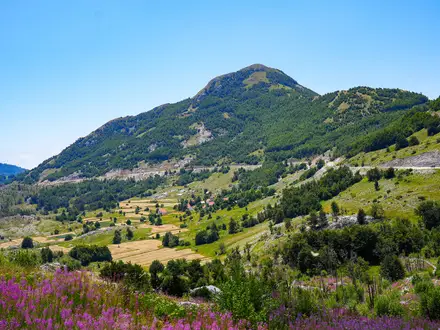
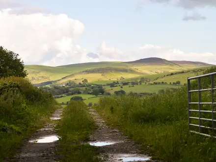
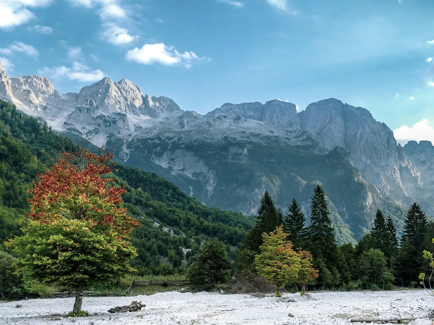
The Peaks of the Balkans Trail is a 192 km waymarked loop through the Accursed Mountains, crossing Albania, Kosovo and Montenegro. The classic itinerary takes 10 days and is best treated as a moderate mountain trek: no technical climbing on the main route, but long days, high passes, rocky paths and around 9,800 m of cumulative ascent. It suits fit hikers who want village-to-village walking, remote alpine valleys, guesthouse stays and a genuine cross-border journey.
Route Overview
This is a circular trail, not a point-to-point route, and it can be walked in either direction. Most hikers start and finish in Theth, Albania, while Plav/Gusinje in Montenegro and Peja/Pejë or Reka e Allages in Kosovo are also common trailheads. Shkoder is the easiest gateway town for organising logistics. The loop links Theth, Valbona Pass and Valbona Valley, Cerem, Doberdol, Milishevc, the Rugova region, Babino Polje, Plav, Vusanje/Vuthaj and Gusinje, with the Triangle/Tromedja three-border area marking the symbolic high point. From the Plav-Gusinje basin, related Montenegro hikes include Grbaja Valley to Karanfili and Ali Pasha’s Springs Trail.
A Modern Peace Trail on Old Mountain Routes
The Peaks of the Balkans Trail was created in 2012 as a cross-border tourism project led by GIZ with local hiking clubs and tourism organisations in Albania, Kosovo and Montenegro. Its aim was to bring income to isolated mountain communities and reconnect areas separated by recent conflict and closed borders. The route revives old Ottoman-era mule, trade and herders’ paths through the Accursed Mountains, which is why it is often described as a “peace trail”.
Notable highlights
- Theth to Valbona Pass crossing (~1,800 m): The best-known stage climbs steeply between Albania’s Theth and Valbona national parks, with long views into both glacial valleys.
- Valbona Valley, Albania: A broad glacial valley framed by limestone walls, with riverside guesthouses below the Albanian Alps.
- Doberdol and Cerem high katuns: Remote summer shepherd settlements where simple guesthouses and grazing livestock give the route much of its mountain character.
- The Triangle / Tromedja (~2,300 m+): The meeting point of Albania, Kosovo and Montenegro, and the symbolic centre of this cross-border loop.
- Plav and Gusinje basin, Montenegro: A lake-and-mountain base in Prokletije National Park, useful for side trips such as Grbaja/Grebaje Valley and Ali Pasha Springs.
- Rugova region, Kosovo: The trail passes through Kosovo’s Bjeshket e Nemuna/Rugova area; nearby peak objectives include the Hajla Peak Trail.
Challenges to expect
Expect repeated 5–8 hour mountain days, often with around 1,000 m of ascent and descent. Surfaces include rocky mule tracks, dirt meadow paths, scree and possible snow on high sections in early summer or from late September. Cross-border permits are mandatory, cash is needed for village accommodation, and there are no ATMs between the main towns. Weather can change quickly at altitude.
HikeList Score
Peaks of the Balkans Trail scored 93/100 on HikeList's trail-quality metrics.
See score breakdownHide breakdown
- Ideal length 94
- Balanced challenge 100
- Scenery & wildness 98
- Varied terrain 77
- Accommodation 92
- Food & support 88
- Path quality 98
- Season flexibility 76
Computed from length, challenge, scenery & wildness, terrain variety, accommodation, food & support, path quality and season flexibility.
Show more data Show less
- Mountainous
- Alpine
- Rocky
- Dirt
- Scree
- Snow
- Guesthouses
- Huts
- Campsites
- Wild Camping Spots
- Hostels
- Family Friendly
- Dog Friendly On Leash
- Potable Water Sources
- Non Potable Water Sources
- Established Campsites
- Shelters
Download Our Full Guide to Peaks of the Balkans Trail FREE!
Get our comprehensive guide to this hike for free. Save it for later reading or print out at home.
In these collections
Peaks of the Balkans Trail: The Complete Guide
 i
Image by Pixabay
i
Image by Pixabay The Peaks of the Balkans Trail is a 192 km circular trek through the Accursed Mountains — Prokletije / Bjeshkët e Nemuna — linking Albania, Kosovo and Montenegro on foot. The standard itinerary starts and finishes in Theth, but the loop can also be joined from Plav or the Kosovo side and walked in either direction.
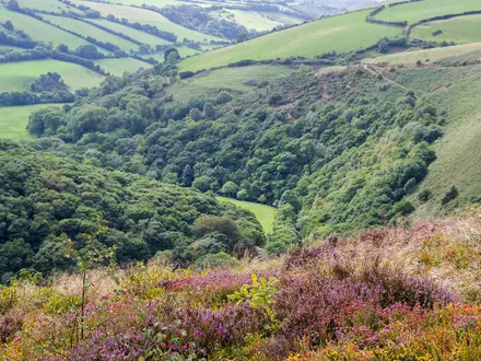
This is a village-to-village mountain journey rather than a peak-bagging route. The path crosses high passes, rocky mule tracks, beech forest, scree slopes and glacial valleys, with nights in family guesthouses and summer shepherd settlements such as Çeremi, Dobërdol and Milishevc.
The trail’s centrepiece is the Tromedja / Triangle area, around 2,300 m, where the three borders meet in open mountain country. Elsewhere, the route moves from the deep Albanian valleys around Theth and Valbona to the Rugova region of Kosovo and the broader Plav–Gusinje basin in Montenegro.
Its appeal is not just the scenery. Created as a cross-border trail in 2012, the route links communities that were long separated by hard borders, and the remaining bunkers in the Albanian and Kosovo landscapes are a reminder of how recently these mountains were closed to outsiders.
The main trail has no technical climbing, but it is still a serious trek: long days, significant ascent and descent, rough paths, variable waymarking, mandatory cross-border permits, cash-only mountain stages and no through public transport on the route. It suits fit hikers with previous multi-day mountain experience, not first-time long-distance walkers.
This guide covers the stages, walking days, accommodation, food, transport, terrain, permits and common planning mistakes.
Stage-by-Stage Guide
The stage notes below follow the common anticlockwise itinerary from Theth. The loop can also be started from Plav or the Kosovo side, and the same mountain cautions apply in either direction: carry a downloaded GPX track, keep the cross-border permits in order, and do not rely on shops between the main towns.
Stage distances on the Peaks of the Balkans vary slightly between maps and guidebooks, and several days have common variants. Check the day’s line against a current GPX before setting out.
Stage 1: Theth to Valbona — approx. 17 km
This is the classic Theth–Valbona Pass crossing and the busiest mountain day on the route. It climbs from Theth at around 745 m to Qafa e Valbonës / Valbona Pass at roughly 1,759–1,805 m, before descending into the broad Valbona Valley.
The walking starts easily on gravel road and riverside tracks out of Theth, with wooden bridge crossings over the Theth River early in the day. The path then climbs through beech and pine forest on switchbacks before becoming rockier and more alpine near the pass.
The pass itself is an open rocky saddle with wide views back to the Theth valley and ahead into Valbona. A small seasonal café or shelter may operate near the top, but this should be checked before travelling and should never replace carrying food and water.
Water is usually available from springs on the ascent, but sources can dry in high summer. Carry enough for the full climb, especially in July and August.
The descent to Valbona is long, rocky in places and tiring on the knees. Trekking poles are strongly advised, and lingering snow can make the narrow upper sections awkward in June or late September.
Valbona has several guesthouses, including Bujtina Valbonë, Villas Jezerca and Bujtina Izet Selimaj. The valley is spread out along the river, so confirm where the guesthouse is in relation to the next day’s trailhead; a poorly placed booking can add unwanted road walking.
There are no meaningful resupply options in Valbona, so half-board at the guesthouse is the normal arrangement. Road access exists and taxi or minibus transfers between Theth and Valbona are sometimes used if weather, injury or fitness makes the pass unsuitable, but this should be arranged locally in advance where possible.
Navigation is relatively straightforward by Peaks of the Balkans standards because the stage is well-trodden and well-marked. A GPX track is still essential, especially if cloud drops onto the pass.
Stage 2: Valbona to Çeremi — approx. 13 km on the standard itinerary
This stage has two commonly used lines: the lower official route along the Valbona Valley, and the harder high variant over Prosllopit Pass / Qafa e Prosllopit, also known as Bor Pass. The valley route is shorter and easier but includes road and track walking; the Prosllopit variant is more demanding and much more scenic.
The official route follows rough road and track in the Valbona River valley, with sections of asphalt and damaged road. Some walkers arrange a 4x4 transfer for the first road section, particularly in hot weather or when trying to reduce impact on a long 10-day itinerary.
The Prosllopit Pass variant climbs from around 950 m in Valbona to roughly 2,030 m. It passes through old beech forest, open alpine meadows and rocky karst terrain, with a steep descent towards Çeremi.
Ledena Pecina, an ice cave with year-round snow or ice in a ground-level cavity near the pass, is a notable feature on the high variant. The descent is the main difficulty: it is sharp, rocky and can be slippery after rain.
Do not take the Prosllopit variant in poor visibility, heavy rain or unstable weather. It is a full mountain route rather than a simple valley transfer, and trekking poles are very useful on the descent.
Water is available at points on the ridge, but there is no reliable supply on the descent, so fill up when possible. There are no shops or cafés on arrival in Çeremi beyond what the guesthouses provide.
Çeremi is a small summer village with very limited accommodation, including Kujtim Gocaj Guesthouse and VITA Guesthouse. Book ahead, take cash, and expect a simple half-board arrangement rather than à la carte meals.
Public transport is not a practical option for this stage. Road and 4x4 access exists on the lower approach, but once committed to the high variant the route is remote.
Navigation depends on the option chosen. The valley route is more obvious, while the Prosllopit line needs careful GPX use, particularly around the pass and karst descent.
Stage 3: Çeremi to Dobërdol — approx. 17 km
This is a steady climbing day into one of the most remote Albanian sections of the trail. It rises from Çeremi, around 1,150 m, towards the high summer pastures of Dobërdol at roughly 1,750–1,930 m.
The stage is often one of the gentler days underfoot, with dirt road above the village, forest trail, meadow crossings and a final steeper rise into Dobërdol. It passes through the Gashi Nature Reserve, a strict nature reserve within the Albanian Alps, where walkers should stay on the through-route and avoid unnecessary disturbance.
The primeval beech forest is the defining feature of the day. In season, small shepherd huts along the route may sell coffee, fresh juice or snacks, but these are not guaranteed and should not be treated as resupply points.
Water is usually available from springs during the climb. In Dobërdol, treat or filter drinking water; purification tablets or a filter are sensible on this stage.
An optional detour to the Trekufiri / Tromedja tri-border summit area can be made from the ridge in clear weather. This is the symbolic meeting point of Albania, Kosovo and Montenegro, but the summit detour is not part of the main through-route.
Dobërdol is a very remote summer settlement, with Bashkimi Guesthouse the key accommodation option. Facilities are simple, with limited generator electricity, and there are no shops or alternative services.
Half-board is essential here. Carry a packed lunch from Çeremi and enough cash, as there are no ATMs between the major towns.
Road access is extremely limited compared with the lower valleys, and there is no useful public transport. Navigation is generally manageable in good weather, but mist on the open pastures can make the final approach more confusing, so follow the GPX carefully.
Stage 4: Dobërdol to Milishevc — approx. 18 km
This stage crosses from Albania into Kosovo over high border ridges. The crossing is not at a staffed checkpoint, so the required cross-border permit must already be arranged before the trek.
The route climbs from Dobërdol to ridgeline terrain above 2,100 m, with rolling high pastures, herb meadows, glacier tarns and open views. It then descends through spruce forest towards Milishevc.
The area around the Bogice Pass and Roshkodol Pass sections is one of the most atmospheric parts of the loop. In clear weather, it also gives access to the Tromedja / Triangle three-border area, either as a short scramble from the ridge or as a detour done the previous day.
Gjeravica, Kosovo’s highest mountain at 2,656 m, can be added from this high area, but it is not part of the Peaks of the Balkans through-route. It needs extra time, a very early start or an additional day.
Navigation is the main issue on this stage. Markings can be confusing, some signs are missing, and there are several junctions where the wrong track can cost time and height; a reliable GPX track and offline map are essential.
Water is available in the high country, but carry enough between known sources and avoid assuming every tarn is suitable for drinking without treatment. There are no shops on the stage.
Milishevc has several guesthouse options, including Chalet Rrusta, and is generally a more comfortable stop than Dobërdol. Meals are normally provided by the guesthouse, with local dairy dishes common.
There is no through public transport. Road access may exist for local vehicles, but this should not be relied on for an unplanned exit unless arranged through the accommodation or a trail operator.
Stage 5: Milishevc to Rekë e Allagës — approx. 16 km
This is a high Kosovo stage with a steep climb to the Bjeshka e Lumbardhit / Lumbardhi ridge, followed by a long descent into the Rugova region. It is not especially long on paper, but the descent is rough and can be slow.
The route climbs on steep grass trail to above 2,100 m, where there are views towards Gjeravica in good conditions. From the ridge, the descent becomes rockier, with loose gravel, black rock and slippery sections before forest switchbacks lower down.
Trekking poles are particularly useful on this day. Take care on the loose descent, especially after rain, and watch for snakes near the lower treeline in warm weather.
The lower part of the stage reaches the Rugova Valley, one of Kosovo’s major mountain landscapes. The final kilometres can involve asphalt road walking, and traffic can be noticeable in summer.
Rugova Camp in Malaj village is a useful break point on or near the lower valley section, with food available, including trout from nearby fish ponds. Some walkers split the day or stay there instead of continuing, depending on their itinerary.
The final 6–6.5 km from Rugova Camp towards Rekë e Allagës can be skipped by arranging a car transfer. This is useful if the road is busy, the weather is very hot or knees are already tired from the descent.
Accommodation at Rekë e Allagës includes Ariu Guesthouse, which is well placed for the trail. Food is normally through the guesthouse; do not expect shops or independent resupply.
Navigation is clearer on the ridge than on some other stages, but the descent and lower road connections still require attention. Keep the GPX active through the transition from mountain path to valley road.
Stage 6: Rekë e Allagës to Drelaj — approx. 10 km on the 10-day itinerary
This is one of the stages where itineraries differ most between guidebooks and operators. Some schedules split the Rekë e Allagës, Guri i Kuq and Babino Polje section differently, while the 10-day itinerary uses a shorter day to Drelaj before continuing to Babino Polje.
The route generally starts with road or track ascent before moving onto more open mountain terrain. The wider area includes the glacial lakes at Liqinati / Liqenat and the high Guri i Kuq / Red Stone area near the Kosovo–Montenegro border.
Hajla Peak, a distinctive plateau summit around 2,403 m, is a major optional addition where conditions and timing allow. It gives one of the best viewpoints on the route, but it adds exposure, ascent and weather risk, so it should not be treated as automatic.
The terrain includes rocky paths and open ridgeline sections, followed by a descent towards Drelaj. Road sections are more obvious than the high mountain path, but the descent still benefits from GPS checking.
Water and food availability are limited. Carry lunch from Rekë e Allagës and enough water for the high ground, topping up only where a reliable source is available.
Drelaj is a small border-area village with simple accommodation, including Shquiponja and Bujtina Kaçaku. Book ahead, take cash, and expect basic mountain hospitality rather than full services.
Some hikers arrange a jeep transfer for the final road walking into Drelaj. There is no dependable through public transport for linking the trail stages, so transfers need to be organised through accommodation or a local operator.
Because this section can vary significantly by chosen line, the day’s GPX matters more than the headline distance. Make sure the booked accommodation matches the route variant being walked.
Stage 7: Drelaj to Babino Polje — approx. 15 km
This stage crosses into the Montenegrin side of the Prokletije / Bjeshkët e Nemuna landscape, with forest, high plateau terrain and the option to visit Hrid Lake. It is a substantial mountain day despite the moderate distance.
The route leaves Drelaj on a paved lane before joining forest track and then higher alpine ground with dwarf pine. Rocky trail appears around the lake area and the open plateau can feel exposed in poor weather.
Hrid Lake, also known as the Lake of Happiness, sits at around 1,970 m below Hrid Rock. The short detour to the shore is well worth making in settled weather, and swimming is possible in summer.
The route also passes a Yugoslav-era tri-point border monument on the ridgeline. Summer livestock grazing is common, with cattle and sheep on the plateau.
Livestock guardian dogs may be present. Do not run, do not turn your back, and use trekking poles calmly as a visual barrier while giving the animals space.
There are no shops on the stage and no reliable resupply. Carry lunch from Drelaj and enough water, especially in warm weather when the open plateau can be draining.
Babino Polje is a remote summer shepherd settlement in Montenegro’s Prokletije National Park. Accommodation is simple, with limited guesthouse or katun-style options; local food may include honey and pršut, but meals should be arranged with the accommodation.
Cash is essential and mobile signal can be unreliable. There is no useful public transport, and road access should be treated as local or pre-arranged rather than a dependable escape option.
Stage 8: Babino Polje to Plav — approx. 20 km
This is a mostly descending stage from the high pastures to Plav, the main service town of the entire route. It drops from around 1,730 m at Babino Polje to about 950–968 m at Plav.
The terrain is varied rather than technically hard: jeep tracks through mountain pasture, old pine forest, logging trails and country lanes. The descent is long, with around 1,200 m of height loss, so it still takes a toll.
If Hrid Lake was not visited on Stage 7, the upper part of this section may offer another opportunity depending on the exact route line. Otherwise, the day’s main value is the gradual return from remote mountain terrain to full town services.
Navigation is generally more straightforward than the border-ridge stages, but logging tracks and lanes can still create uncertainty. Follow the GPX where tracks branch in the forest.
Plav sits beside Lake Plav / Plavsko Jezero and is the only town on the loop with a full range of services. It has ATMs, pharmacies, shops, bakeries, restaurants, guesthouses and small hotels.
Withdraw enough cash in Plav for the remaining stages, as it is the only ATM stop on the route. This is also the best place to replace snacks, sort minor gear problems and take a rest day if needed.
The trail may bypass the town centre slightly, so a short transfer or extra walk may be needed depending on where accommodation is booked. Plav has road access and is one of the more practical points for joining, leaving or pausing the trek.
Side trips from Plav include the Grbaja / Grebaje Valley and Ali Pasha’s Springs near Gusinje. These are best treated as rest-day additions rather than part of the through-stage.
Stage 9: Plav to Vusanje — approx. 22 km
This is one of the longest and most demanding days of the standard itinerary. Some route descriptions measure it longer than 22 km, and the combination of road approach, major ascent and long descent makes it a serious mountain stage.
The day starts with asphalt out of Plav, including a long road section that many hikers skip by 4x4 transfer. In July and August, start very early if walking the road, as it can be hot and exposed.
After the road section, the route moves onto dirt track and a steep forest climb. Radunov Laz gives good views towards Lake Plav, the Ljuča River and Visitor Mountain, while Katun Paljvukaj is a useful summer hut area with water.
Higher up, the route climbs through grassy alpine meadows and onto the ridge towards Bor Peak / Maja e Borit at 2,106 m. Ruined military blockhouses near the summit area and Katun Grlata below the peak are notable landmarks.
The views from the Bor Peak area reach back towards Lake Plav and forward towards the Albanian border ridge. In August, wild blueberries may be found on the upper slopes.
Water is available at springs such as Radunov Laz and Katun Paljvukaj, but carry enough from Plav to reach the first reliable source. There are no shops between Plav and Vusanje.
The descent to Vusanje is long, steep and tiring, particularly late in the day. Trekking poles are essential, and the upper ridge is exposed to sun, wind and storms.
Vusanje / Vuthaj is a small Montenegrin village near the Albanian border, with accommodation including Guesthouse Kollata. It is the base for the final crossing back to Theth via the Ropojana and Peja Pass area.
Road access exists to Vusanje, so pre-arranged transfers may be possible. There is no practical through public transport for linking the walking stages.
Zla Kolata / Maja e Kollatës is an optional mountaineering add-on from this wider area, but it is not part of the Peaks of the Balkans through-route and requires proper equipment and local guidance.
Stage 10: Vusanje to Theth — approx. 20 km
The final stage closes the loop by crossing back from Montenegro into Albania over Peja Pass / Qafa e Pejës. It is a long mountain day, and the finish into Theth often takes longer than expected.
The route leaves Vusanje on dirt track into the Ropojana area and the Fusha e Runicës high valley, enclosed by steep rock faces. Stream crossings, karst limestone scenery and rougher mountain paths give the stage a wilder feel than the distance alone suggests.
A vivid blue karst spring in the Ropojana Valley — signposted on the trail as Syri i Skakavicës / Oko Skakavice ("Grasshopper's Eye") — is a major highlight of the day. It is still a mountain-stage feature rather than a resupply stop, so carry food from Vusanje.
The climb to Peja Pass reaches roughly 1,710–1,736 m and forms the final border crossing into Albania. The pass is exposed to weather, and afternoon storms are a genuine concern in summer.
Aim to cross the pass before noon where possible. Early June and late September can bring snow, mud or colder weather on this section, so conditions should be checked before travelling.
The descent to Theth is rocky, steep in places and longer than many walkers expect after the pass. Poles help protect knees and improve balance on loose ground.
Near Theth, Grunas Waterfall is a worthwhile short detour if time, weather and energy allow. Theth has multiple guesthouses, including Bujtina Tinari and Bujtina Pllumi, along with small basic shops.
Theth has better services than the high villages but remains a cash-based mountain settlement. Albanian lek may be needed at some guesthouses, while euros are widely used for tourism pricing.
Road access from Theth makes it the standard trailhead and a practical place to finish or exit. There is no through public transport on the route itself, so onward transfers should be arranged before finishing if travelling to Shkodër, Tirana or another gateway.
An overnight stop at Zastan, a shepherd hut area before the final pass, can be used to avoid making the Vusanje–Theth crossing in one very long day. This should be booked or checked before travelling.
Recommended Itinerary
The standard Peaks of the Balkans schedule is a 10-day anticlockwise loop from Theth. It is the most practical itinerary for most fit hikers because it matches the established guesthouse stops and avoids trying to combine long mountain stages with limited services.
Set border-permit dates around the three green-border crossings in this itinerary: Dobërdol to Milishevc, Drelaj to Babino Polje, and Vusanje to Theth. Printed copies should be carried, and any changed dates should be checked before travelling.
Standard 10-day itinerary from Theth
| Day | From | To | Approx. distance | Why this stage makes sense | Services/accommodation notes |
|---|---|---|---|---|---|
| 1 | Theth | Valbona | 17 km | Starts with the classic Theth–Valbona Pass crossing, the best-known stage of the trail. It is a substantial first day but has reliable accommodation at both ends. | Theth has a small shop and many guesthouses. Valbona is well served by guesthouses, but do not treat it as a major resupply stop. |
| 2 | Valbona | Çeremi | 13 km | A shorter distance on paper, but still a demanding mountain day over remote ground. Some walkers shorten the initial road section by arranging a local vehicle transfer. | Çeremi is a tiny seasonal village with very limited guesthouse capacity and no reliable shop. Arrive with enough cash and food arranged for the next stage. |
| 3 | Çeremi | Dobërdol | 17 km | Climbs into the high pasture country and positions you well for the Kosovo crossing. The Tromedja / Triangle three-border area is nearby, but the main route should not be confused with optional summit detours. | Dobërdol is a remote katun with simple seasonal guesthouses. Expect basic facilities, limited charging, no shop and no phone signal. |
| 4 | Dobërdol | Milishevc | 18 km | Crosses from Albania into Kosovo, making this one of the key permit days. The stage links the Albanian high pastures with the Rugova side of the mountains. | Milishevc usually has more comfortable guesthouse options than the high Albanian katuns, with better washing and charging facilities in some places. Border permits must already be in place. |
| 5 | Milishevc | Rekë e Allagës | 16 km | A full Rugova mountain stage through pasture country, with a known road-walking section that some hikers shorten by jeep. | Rekë e Allagës has only simple guesthouse accommodation. Do not rely on shops; carry what is needed between guesthouse meals. |
| 6 | Rekë e Allagës | Drelaj | 10 km | The shortest day on the standard itinerary, useful for recovery after several remote stages. It also gives some flexibility if weather or tiredness has slowed earlier days. | Drelaj has more village services than the high katuns, but it is still not a main resupply point. Guesthouse booking remains advisable in peak season. |
| 7 | Drelaj | Babino Polje | 15 km | Crosses from Kosovo into Montenegro, so this is the second major border-permit day. The route enters the Montenegrin side of the Accursed Mountains. | Babino Polje is a small mountain village with limited services and simple guesthouses. Carry printed permit paperwork and enough cash. |
| 8 | Babino Polje | Plav | 20 km | A longer but generally logical stage down towards the Plav basin. Reaching Plav resets the logistics after several limited-service villages. | Plav is the key resupply stop on the loop, with ATMs, supermarkets, bakeries, pharmacies, restaurants and small hotels. Stock up here before the final two stages. |
| 9 | Plav | Vusanje | 22 km | Commonly treated as the hardest day because of its length and cumulative effort. It is worth starting early, especially in hot weather or if not using any vehicle shortcut. | Plav is the last reliable place for cash and supplies. Vusanje, also known as Vuthaj, has basic guesthouses near the Albanian border. |
| 10 | Vusanje | Theth | 20 km | Closes the loop by crossing back into Albania, making this the final border-permit day. The stage passes a blue karst spring in the Ropojana Valley before climbing to the pass and descending into Theth. | Theth has multiple guesthouses and food options at the finish. A 4WD transfer from Vusanje can shorten the early road section if arranged locally. |
Slower 12- to 13-day variant
A slower schedule suits hikers who want rest days, more margin for poor weather, or optional summit and valley side-trips. It is also a sensible choice if travelling in September, when shorter days and colder weather can make early starts less appealing.
The easiest places to add time are:
| Extra time | Where to add it | Why it works | Planning note |
|---|---|---|---|
| 1 day | Dobërdol | Good recovery point after the first high Albanian stages, and a base for exploring the surrounding pasture and three-border area. | Facilities are basic and seasonal, so book ahead and do not rely on phone signal. |
| 1 day | Plav | Best logistical rest stop on the route, with ATMs, shops, pharmacies, restaurants and hotel-style accommodation. | Useful before the long Plav to Vusanje stage. This is the best place to replace snacks, toiletries and cash. |
| 1 day | Milishevc or the Kosovo section | Allows time for an optional Gjeravica side-trip or a more relaxed passage through the Rugova region. | Optional summit days change distances and timing; check official mapping before booking. |
A 12-day plan usually means walking the same 10 stages and adding two rest or side-trip days. A 13-day plan gives more buffer if snow, storms or border-permit timing affects the high crossings.
Faster 7- to 8-day variant
A faster itinerary is only suitable for strong, experienced mountain hikers who are comfortable with long days, steep ascent and limited bailout options. It normally depends on combining one or more stages and using local 4WD, jeep or taxi transfers for road sections.
| Time-saving option | Where it is usually applied | What it changes | Caution |
|---|---|---|---|
| Combine shorter Kosovo stages | Around Milishevc, Rekë e Allagës and Drelaj | The 10 km Rekë e Allagës to Drelaj stage can be absorbed into a longer day by very fit hikers. | Combined distances and ascent become much harder than the stage table suggests. Check official mapping before booking. |
| Use vehicle transfers for road sections | Valbona to Çeremi approach, parts of the Kosovo road walk, and sections around Vusanje | Saves time and energy without changing the mountain core of the route. | Availability and prices change by season; arrange locally through guesthouses or operators and confirm before relying on it. |
| Skip the Kosovo arc via a Dobërdol to Babino Polje shortcut | High-border area between Albania and Montenegro | Can reduce the walk to roughly a week. | Not recommended for most hikers because it misses the Rugova section and changes the character of the route. Permit requirements must be checked before travelling. |
Avoid compressing the Plav to Vusanje and Vusanje to Theth finish into one day. Those are already long mountain stages, and the final Albania crossing should be treated as a full day with its own permit timing.
Planning the Route
How many days to allow
The standard Peaks of the Balkans itinerary is 10 walking days, and that is the most sensible baseline for independent hikers. Daily stages are usually around 15–22 km, with 5–8 hours of walking and substantial climbing on rocky mountain paths.
A 6–7 day schedule is possible for very fast hikers, but it usually means compressing stages, using transfers, or omitting part of the loop. Fewer than 10 days removes much of the margin needed for weather, permit dates and tired legs.
A better plan for most walkers is 11–12 days door-to-door on the trail, with at least one buffer or rest day. A 12–13 day itinerary gives space for rest days in Theth, Valbona or Plav, and for optional summit side-trips without turning the main route into a rush.
Why the stages are not very flexible
This is not a route where walkers can stop wherever the legs feel tired. The stage pattern is strongly dictated by where guesthouses and katuns exist.
Between the larger bases, accommodation is mainly found in the named overnight settlements: Çeremi, Dobërdol, Milishevc, Rekë e Allagës, Drelaj, Babino Polje and Vusanje. These are small mountain villages or summer pasture settlements, often with only a handful of family-run places.
For that reason, the standard 10-stage itinerary is practical rather than arbitrary. There may be ways to split or shorten some longer days using local transfers or intermediary stops such as Liqenat or Kučište, but this should be checked before travelling.
| Planning point | What it means on this trail |
|---|---|
| Accommodation spacing | Beds determine the daily stages more than personal preference. |
| Remote sections | Çeremi, Dobërdol and Milishevc have no shops, limited services and simple lodging. |
| Long days | Plav–Vusanje and Vusanje–Theth are among the longer stages in the standard itinerary. |
| Flexibility | Extra days are easiest in Theth, Valbona and Plav rather than in the high katuns. |
Direction and start point
Theth is the standard trailhead and the most common start for an anticlockwise circuit, but the route is a loop and can be walked in either direction. Plav and the Pejë / Rugova side are also practical joining points.
Choose the start point around transport, permit dates and accommodation availability rather than scenery alone. Theth works well for those entering via Tirana or Shkodër; Plav works for those arriving through Podgorica; Pejë is the logical Kosovo gateway for the Rugova side of the route.
Starting somewhere other than Theth does not remove the need for border permits. It simply changes the order and dates of the crossings.
Plan permits before anything else
For the full loop, three cross-border permits are mandatory because the trail crosses green borders away from official checkpoints:
- Albania to Kosovo
- Kosovo to Montenegro
- Montenegro to Albania
The Albania and Kosovo electronic permits are free. Montenegro charges a police fee, and facilitation services such as Zbulo charge an additional handling fee. Current permit costs should be checked before applying.
The key issue is not just having the permits, but matching them to the correct crossing dates. Border police normally allow only limited date flexibility, so a badly delayed itinerary can create problems at the next crossing.
Apply at least two weeks before departure, and preferably four to six weeks ahead in high season. Applications can be made up to eight weeks in advance, and processing normally takes several business days.
Travelling without permits can lead to fines or on-the-spot problems with police. Do not treat the border paperwork as an optional formality.
Accommodation strategy
Book ahead in July and August. Guided groups can fill entire guesthouses, and the tightest pinch points are often Theth, Valbona and Çeremi.
A practical independent approach is to book the first nights firmly before arrival, especially Theth and Valbona, then keep contact with later guesthouses by phone or WhatsApp as the walk progresses. In peak season, leaving every night unbooked is a risk.
Outside July and August there is usually more flexibility, but early June and late September need extra care. Guesthouses may not yet be open, or may be closing for the season. This should be checked before travelling.
Most village guesthouses provide dinner, breakfast and a packed lunch as part of the stay. Typical rates are around €25–40 per person per night, but current prices should be confirmed before booking.
Carry enough cash for the full remote section. Montenegro and Kosovo use euros; Albania’s official currency is the lek, though tourism prices are often quoted in euros and some Albanian village guesthouses may prefer cash in lek. There are no ATMs between the main towns.
Food, water and resupply
Do not plan this as a supermarket-to-supermarket hike. In the remote katuns such as Çeremi, Dobërdol and Milishevc, meals come from the guesthouse and there are no shops for proper resupply.
Most walkers carry only daytime snacks plus the packed lunch supplied by the guesthouse. Plav is the main resupply point on the loop, with supermarkets, an ATM and a pharmacy.
Mountain water is generally available, but high sources can dry by late August. Ask the guesthouse each morning about the next reliable water point, especially before high passes or long exposed sections.
Navigation planning
The route is waymarked with red-and-white blazes, but the marking is not consistent enough to rely on alone. High sections, open pastures and border crossings are the places where navigation needs the most attention.
Download offline GPX files before leaving the gateway town. Mobile signal is unreliable or absent in the mountains, so the route should be available offline on a phone and backed up with a paper map.
The Peaks of the Balkans 1:60,000 topographic map is the main paper map for the route. Carry a power bank if using a phone for navigation every day.
Weather and seasonal timing
The reliable walking season is mid-June to mid or late September, when most passes are snow-free and guesthouses are open. July to September normally gives the most stable conditions.
Before mid-June, snow can linger above 1,800 m and early-season crossings may require winter equipment. After mid-September, early snow, shorter days and guesthouse closures become more likely.
A buffer day is not just for comfort. On this route it protects permit dates, accommodation bookings and transport plans if storms or snow slow progress.
Transport and baggage planning
There is no through public transport along the route itself. Transport planning is about reaching the start, leaving the finish, and occasionally arranging local transfers if a stage needs shortening.
Common gateway options are:
| Gateway | Typical onward plan |
|---|---|
| Tirana / Shkodër | Minibus to Theth, or access towards Valbona via the Koman Lake route. |
| Podgorica | Bus to Plav. |
| Pristina / Pejë | Bus to Pejë, then local taxi or minibus towards the Rugova trailheads. |
From Tirana, travel is commonly via Shkodër and then onward by minibus to Theth. Albanian minibuses may not run to fixed timetables, so departure times should be checked the day before, ideally through the accommodation.
Baggage transfer can be arranged through trail operators or guesthouses on some sections, using mules, horses or 4x4 vehicles depending on the terrain. Use soft bags only; suitcases are unsuitable, and a limit of around 15 kg is typical.
Shortening, extending and section hiking
Shortening the loop is possible, but it usually weakens the character of the route. Skipping the Kosovo section removes one of the three countries and the high Tromedja / Triangle area, so it is best treated as a last resort rather than a recommended variant.
A more sensible way to reduce effort is to use local transfers on dull road or track approaches where available. This should be arranged through guesthouses or local operators, not assumed on arrival.
Extending the route is much easier. Theth, Valbona and Plav are the best places for rest days, and Plav is particularly useful as a mid-route reset because it has shops, an ATM and a pharmacy.
Optional summit day-hikes such as Maja Jezercë or Maja e Kollatës are off the through-route and should be planned as separate mountain days. They require additional time, suitable conditions and stronger mountain judgement than the main trail.
Section hiking is practical from Theth, Valbona, Plav or Pejë / Rugova, but partial exits can be awkward. Villages such as Milishevc or Drelaj do not have regular public transport, so leaving mid-route usually needs private or local transport.
Section hikers only need permits for the borders they actually cross, but the same date-specific rules apply. Fix the route first, then apply for the relevant crossings.
Best order for planning
Plan the route in this order:
- Choose the start point: Theth, Plav or Pejë / Rugova.
- Set a realistic walking schedule, usually 10 days plus at least one buffer day.
- Fix border-crossing dates and apply for permits.
- Book key accommodation, especially Theth, Valbona and Çeremi in high season.
- Arrange transport to the gateway town and onward to the trailhead.
- Download offline GPX files and obtain the 1:60,000 trail map.
- Organise baggage transfer if needed.
- Withdraw enough cash before leaving the main towns.
- Recheck guesthouse opening, water information and weather immediately before starting.
Towns, Villages and Overnight Stops
Accommodation on the Peaks of the Balkans is mainly family-run guesthouses, with simple shepherd huts or katun accommodation in the high pasture settlements. Full board is the norm: dinner and breakfast are usually included, with a packed lunch available on request, commonly for about €5 extra.
For budgeting, expect roughly €35–55 per person per night in most places, though facilities vary sharply. Cash is essential. Kosovo and Montenegro use the euro; Albania’s official currency is the Albanian lek, and some village guesthouses may prefer cash in lek even when prices are discussed in euros.
Book July and August beds 1–3 months ahead where possible. Çeremi, Dobërdol, Milishevc and Babino Polje have limited capacity, and organised groups can take most or all available beds in a small settlement.
| Stop | Role on the route | Practical importance |
|---|---|---|
| Theth | Standard start/end in Albania | Major guesthouse base; no ATM |
| Valbona | End of Stage 1 | Developed valley base; dispersed accommodation |
| Çeremi | End of Stage 2 | Tiny summer village; very limited beds |
| Dobërdol | End of Stage 3 | Remote high katun; basic facilities |
| Milishevc | End of Stage 4 | Remote Kosovo stop; short operating season |
| Rekë e Allagës | End of Stage 5 | Dispersed Rugova village; limited supplies |
| Drelaj | End of Stage 6 | Road-accessible Kosovo village |
| Babino Polje | End of Stage 7 | Isolated Montenegrin hamlet; no resupply |
| Plav | End of Stage 8 | Only proper town on the route; best resupply |
| Vusanje / Vuthaj | End of Stage 9 | Final Montenegrin stop before returning to Theth |
Theth, Albania
Theth is the standard trailhead for the loop and is also the final overnight stop if walking the common anticlockwise itinerary. It is a remote mountain village in the Albanian Alps, with traditional stone-and-wood houses spread along a glacial valley.
This is one of the best-supplied accommodation bases on the route, with multiple family-run guesthouses. Options include Bujtina Tinari, Bujtina Pllumi, Polia Guest House and Guesthouse Kollata, with typical prices around €40–55 per person including meals.
There is a small mini-market near the tourist information office / above the bridge, selling basic items such as bread, biscuits, snacks and some fruit. Do not rely on Theth for a full resupply. There are cafés and a restaurant or two, but most hikers eat at their guesthouse.
There is no ATM in Theth, so bring cash from Shkodër or another gateway town. Some Albanian guesthouses may accept euros for tourism pricing, but lek can still be useful.
Daily minibuses normally run from Shkodër to Theth, with a morning departure around 07:00, taking roughly three hours and costing about €10. This should be checked before travelling, as timings and departure points can change seasonally. The road is mountainous, winding and bumpy.
The village sits about 2 km off the official circuit, so allow for this when planning the first or final day. Nearby short walks include Grunas Waterfall and the Blue Eye of Kapre, useful if taking an extra night before or after the trek.
Valbona, Albania
Valbona is the overnight stop after the Theth–Valbona Pass crossing and is one of the most developed places on the Albanian side of the trail. It lies in a broad glacial valley below the limestone walls of the Albanian Alps.
The settlement is very dispersed, with guesthouses spread over roughly 8 km along the valley. When booking, check the exact location: staying closer to the Çeremi end of the valley can reduce unnecessary road walking or climbing the next morning.
There is a broad range of accommodation, from simple guesthouses to more comfortable lodge-style stays. Commonly used options include Guesthouse Kol Gjoni, Bujtina Valbonë, Villas Jezerca and Bujtina Izet Selimaj, with typical full-board prices around €40–55 per person.
Food is usually provided by the guesthouse. Simoni Kafe is a well-known hiker stop for tea, coffee and pancakes, and there are several bars in the valley. Local dishes commonly served in the area include flija and byrek.
Shops are limited and there is no full supermarket in the valley. Buy snacks before leaving Theth, or better still bring a more complete supply from Shkodër.
Valbona has 4x4 track access and onward connections via furgon to Bajram Curri. The Komani Lake ferry approach is also commonly used to reach or leave the Valbona side of the Albanian Alps.
Çeremi / Cerem, Albania
Çeremi is the overnight stop between Valbona and Dobërdol. It is a tiny alpine village used mainly in summer, and feels more like a remote pasture outpost than a permanent settlement.
Accommodation is very limited, usually one or two simple guesthouses. Guesthouse Kujtim Gocaj is directly useful for walkers because of its position on the trail; VITA Guesthouse is another option. Expect simple rooms and full-board pricing around €35–45 per person.
There are no shops, no cafés and no ATM. Carry snacks and any personal food from Valbona. Do not expect to buy onward supplies here.
Electricity may only be available for a few hours per day, usually from generator or solar power. Charge phones, power banks and GPS devices before arrival where possible.
Because capacity is so small, Çeremi is one of the stops where advance booking matters most. If walking independently in peak season, do not assume a bed will be available on arrival.
Dobërdol, Albania
Dobërdol is a remote high-altitude shepherd settlement at about 1,750 m and one of the most basic overnight stops on the route. It sits between Çeremi and the Kosovo crossing towards Milishevc.
Accommodation is in simple shepherd shelters or basic bungalow-style rooms. Bashkimi Guesthouse and Leonardi Guesthouse are among the established options, but facilities remain rustic by town standards.
Expect intermittent electricity and do not rely on hot water. There is no phone signal and no Wi-Fi, so Dobërdol is a genuine offline night on the trail.
There are no shops at all. Bring all snacks, medicines and trail food from earlier stops. Water here is not recommended to drink untreated, so carry enough, filter it, or use another reliable treatment method.
Some hikers experience stomach issues around Dobërdol, so take hygiene and water precautions seriously. It is also one of the lower-capacity stops on the whole trail, so book well in advance.
Dobërdol is a useful base for the Tromedja / Triangle three-border area, the symbolic meeting point of Albania, Kosovo and Montenegro. Ask the host locally about the practical access for the following day’s route or any side detour.
Milishevc, Kosovo
Milishevc is the first main Kosovo overnight stop on the standard anticlockwise itinerary, reached after crossing from the Dobërdol area. It is a small, remote high-altitude village with accommodation scattered over more than a kilometre.
Guesthouse capacity is limited, though options have increased since the trail opened. Places used by hikers include Guesthouse Lojza, Kulla guesthouse and Chalet Rrusta / Chale Rusta.
Milishevc is generally more comfortable than Dobërdol, with hot showers available at some guesthouses. Food is typically home-cooked, with local yoghurt, grilled cheese and other dairy products commonly associated with this stop.
There are no shops and no ATM. Carry food and cash through from earlier stops, and do not plan to resupply here.
Milishevc has one of the shortest habitation seasons on the route. Guesthouse opening dates, especially around mid-June and late September, should be checked before travelling.
Rekë e Allagës / Reka e Allagës, Kosovo
Rekë e Allagës is a dispersed village in the Rugova highlands, used as the overnight stop between Milishevc and Drelaj. It is not a compact village centre; houses, chalets and farms are spread across the hillside.
Accommodation has grown since the trail was established, with guesthouses and some villa rentals available. Guesthouse Ariu is positioned beside the trail, while Guesthouse Hajla opens on demand and is useful for walkers considering the Hajla Peak side trip.
Full-board guesthouse pricing is usually in the same broad range as elsewhere on the route, around €40–55 per person. Meals may include Kosovo mountain dishes such as burek and speca me maze.
There are no meaningful shops for a proper resupply. Treat this as a rural overnight stop rather than a service village.
Rekë e Allagës is a possible base for an extra mountain day, including a side trip towards Hajla Peak. If adding this, build in another night rather than trying to force it into a standard through-stage.
Drelaj, Kosovo
Drelaj is one of the larger and more permanent villages in the Rugova region. It is more developed than the previous Kosovo stops and has road access, making it a practical point for joining, leaving or adjusting the route.
Accommodation options are better than in the high katuns. Choices include Guesthouse Shqiponja, Bujtina Kaçaku, Guri I Kuq Hotel-Villa, Mulliri guesthouse-hostel and Peace Guest House.
Guesthouse Shqiponja is a long-standing trail hub and also functions as a restaurant for day hikers. This makes Drelaj a useful reset point after the more remote Milishevc and Rekë e Allagës stages.
Road access means a taxi transfer from Pejë is possible, typically taking around 45 minutes to one hour. Many hikers also use a taxi to avoid the road-walking section between Drelaj and Babino Polje, but this needs to be planned carefully with border permits and the intended route.
Side walks in the area include Liqenat Lakes and Red Stone peak. These are extra mountain days, not part of the standard 10-day through-route.
Babino Polje, Montenegro
Babino Polje is the first Montenegrin overnight stop on the anticlockwise route. It is an isolated alpine hamlet / katun-style settlement near the Kosovo–Montenegro border and lies within the Prokletije National Park area.
Accommodation is limited and generally basic. Triangle Woodhouse and Eko Hrid are among the known options, with simple rooms and shared facilities more common than hotel-style comfort.
There are no shops, no ATM and no practical resupply. Electricity can be intermittent, Wi-Fi should not be expected, and phone signal is effectively absent.
Food is provided by accommodation hosts. Local products such as honey and pršut may appear in meals, and Bajrovica Katun coffee bar is on the trail route.
Babino Polje is sometimes considered poor value compared with other stops because conditions are basic while prices can be relatively high. Its importance is logistical: it breaks the long cross-border section before the descent towards Plav.
Hrid Lake lies nearby and is a worthwhile detour if time and energy allow. Plav, with full services, is the next major stop.
Plav, Montenegro
Plav is the only proper town on the Peaks of the Balkans route and the most important resupply point of the whole trek. It sits by glacial Lake Plav and has the full range of services walkers miss in the high villages.
Accommodation includes guesthouses, small hotels and apartments. Options include Guesthouse Hana, Guesthouse Erdan and Ema Apartments. Check location before booking: lakeside and town-centre / trailhead areas are around 1.5–2 km apart.
Plav has shops, bakeries, restaurants, pharmacies, a market and ATMs. This is the best place to buy trail snacks, replace toiletries, withdraw cash and deal with any minor gear or health issues.
It is the only ATM stop directly on the route. Withdraw enough cash here for the remaining Montenegrin and Albanian stages, especially Vusanje and the return to Theth.
The bus station has regular routes to Podgorica, with several buses per day taking roughly 4–4.5 hours, plus connections towards Berane, Andrijevica and Gusinje. Timetables should be checked before travelling.
Many hikers take an extra night or at least a half-day in Plav. Side trips from the wider Plav–Gusinje basin include Grbaja / Grebaje Valley and Ali Pasha’s Springs near Gusinje.
Vusanje / Vuthaj, Montenegro
Vusanje, also known locally as Vuthaj, is the final Montenegrin overnight stop before the route crosses back into Albania towards Theth. It lies in Gusinje Municipality at the entrance to the Ropojana River valley, close to the Albanian border.
Accommodation is more comfortable and varied than in the remote katun stops. Options include Nature Guesthouse Vuthaj, Guesthouse Moonlight / Dedushi, Guest House Vuthaj and Guesthouse Vucetaj, along with some cabin-style and Airbnb-style stays.
Most walkers eat at their accommodation, though the village has a more developed feel than Babino Polje. Clarify dinner, breakfast and packed lunch when booking, as the next stage back to Theth is long.
The Vusanje to Theth stage is one of the longest on the route, around 20–21 km and often taking about eight hours. Start early, especially if weather is unsettled or if crossing late in the season.
The Ropojana Valley forms the natural corridor for the final crossing back into Albania. Make sure border permits, cash and food are sorted before leaving, as there are no town services before returning to Theth.
Getting to the Start
The standard trailhead is Theth, Albania, usually reached via Shkodër. Because the Peaks of the Balkans is a circular route, it can also be joined at Plav in Montenegro or around Pejë / Rekë e Allagës in Kosovo, but Theth remains the most common start for the classic anticlockwise itinerary.
Before travelling to any trailhead, make sure the cross-border permits for the full loop have been arranged. They cannot be obtained on the day, and transport into the mountains is seasonal, so current timetables should also be checked before travelling.
By train
There is no useful rail access to Theth and no train to Plav. The nearest practical rail option for overland travellers is the Belgrade–Bar railway, which serves places including Bar, Podgorica, Kolašin and Bijelo Polje in Montenegro.
From Podgorica, continue by bus to Plav if starting the trail from Montenegro. From Bar, travel onward by bus via Podgorica before heading into the mountains.
Of the three countries, Interrail/Eurail passes cover Montenegro but not Kosovo or Albania. Rail is therefore mainly relevant for hikers approaching from Serbia, Montenegro or the Adriatic coast, rather than for those starting in Theth.
By bus
Tirana or Shkodër to Theth
The usual route to Theth is:
| Leg | Typical journey | Notes |
|---|---|---|
| Tirana → Shkodër | About 2 hours | Frequent buses from Tirana; fares are typically around €5–11 |
| Shkodër → Theth | About 2–3 hours | Summer furgon / minibus on the paved mountain road |
Shkodër is the main gateway city for Theth. Minibuses to Theth usually leave at around 07:00 from the Rozafa Hotel area and drop passengers near Mini Market Jezerca in Theth.
The Shkodër–Theth minibus is commonly quoted at around €12 / 1,200 lek one way. The fixed summer service generally runs from roughly 15 April to 5 November, but this should be checked before travelling.
Minivans are small, often around 19 seats, and should be booked ahead in July and August. Operators such as Komani Lake Ferry Berisha handle many Albanian Alps transfers, and accommodation in Shkodër or Theth can often arrange seats.
Scenic option via Koman Lake and Valbona
A scenic alternative runs from Shkodër to Koman, then by ferry to Fierze, then onward to Valbona. This is useful if starting the loop from Valbona rather than Theth.
Typical timings and costs are:
| Leg | Typical journey | Typical cost |
|---|---|---|
| Shkodër → Koman | About 3 hours | Around €8 / 800 lek |
| Koman → Fierze ferry | About 2–2.5 hours | Around €10 / 1,000 lek |
| Fierze → Valbona | About 45 minutes | Around €7 |
The Shkodër pickup is commonly from the water fountain on Kole Idromeno Street, with the ferry leaving Koman around 12:00. Operators such as Koman Lake Ferry and Mario Molla offer linked transfers, but current schedules should be checked before travelling.
This route does not take you to Theth. It places you in Valbona, which is the end of the first Theth–Valbona stage on the standard anticlockwise itinerary.
Starting from Plav, Montenegro
Plav is the most practical Montenegrin trailhead and a useful joining point on the loop. From Podgorica, there are usually around five buses daily to Plav, taking about 4 hours and costing roughly €13–20.
Buses pass through Kolašin and Andrijevica. The first departure is commonly around 08:25 and the last around 17:14, but this should be checked before travelling.
Plav has ATMs, pharmacies, supermarkets, guesthouses and small hotels, making it the best resupply point on the whole route. It is a sensible start if arriving through Montenegro.
Starting from Pejë, Kosovo
Pejë is the gateway for the Kosovo side of the route and access to the Rugova villages. From Pristina, buses to Pejë run very frequently, typically every 20 minutes, taking about 2 hours and costing around €10.
From Pejë to Rekë e Allagës, allow about 45 minutes by road. There may be 1–2 daily buses depending on the season; a taxi is typically around €15–20. This should be checked before travelling.
By car
Driving to Theth is now much easier than it used to be, as the road from Shkodër is paved, but it remains a winding mountain approach. Allow for slow progress, especially in poor weather or during busy summer periods.
Theth is a circular-route start, so driving there can work well if the car is left while the loop is walked. Long-stay parking should be arranged directly with your guesthouse before arrival. This should be checked before travelling.
If starting from Plav, parking and pre-walk logistics are generally easier than in the high villages because Plav has more accommodation, shops and services. Again, long-stay parking should be agreed with accommodation rather than assumed.
Do not rely on being able to drive between all trail villages as part of a simple support plan. The route crosses remote mountain terrain, and some guesthouse-to-guesthouse baggage transfers use local 4x4s or mules rather than normal road access.
From the nearest airport
Tirana International Airport for Theth
Tirana International Airport is the most practical airport for the standard Theth start. It is about 17 km north-west of Tirana city centre.
There is no direct airport bus to Theth. A taxi into Tirana costs roughly €20, then buses run from Tirana to Shkodër in about 2 hours. From Shkodër, continue by the morning minibus to Theth.
End to end, Tirana airport to Theth usually takes around 4–5 hours, assuming the onward connections line up. If arriving later in the day, overnight in Shkodër and take the morning furgon to Theth.
Podgorica Airport for Plav
Podgorica Airport is useful if starting in Plav. The airport is about 15 km from Podgorica city centre, with taxis to the bus station typically costing €10–15 and taking around 20 minutes.
From Podgorica bus station, take the bus to Plav. This is normally around 4 hours. Podgorica is less direct for reaching Theth, as it requires crossing into Albania separately.
Pristina International Airport for Pejë
Pristina International Airport is the best airport for joining the route through Kosovo. It is around 15–20 km from Pristina, with taxis to the centre typically around €15.
From Pristina, buses to Pejë take about 2 hours, then continue by taxi, minibus or seasonal bus towards Rekë e Allagës. This is the shortest airport route for hikers beginning on the Rugova / Kosovo side.
Tivat Airport
Tivat Airport is an option if combining the hike with time on the Montenegrin coast. The route is normally Tivat → Kotor → Podgorica → Plav, adding about 2 hours compared with flying directly to Podgorica.
Where to stay before starting
Theth
Staying in Theth the night before walking is the simplest option for the standard start. Family-run guesthouses include places such as Bujtina Tinari, Bujtina Pllumi and Polia Guest House.
In July and August, Theth can fill completely, so accommodation should be booked well ahead, typically 1–3 months in advance. Many guesthouses are around 2 km from the official trail start, so allow time in the morning.
There are no ATMs in Theth. Arrive with enough cash for accommodation, food, transfers and early trail expenses; Albanian lek is the official currency, though tourism prices are often quoted in euros.
Shkodër
Shkodër is the best pre-start base if arriving by bus from Tirana or landing too late to reach Theth the same day. It has a broad choice of hotels and hostels, restaurants, onward transfer options and cash machines.
Use Shkodër to withdraw cash before heading into the Albanian Alps. There are no ATMs in the high katuns such as Çeremi, Dobërdol and Milishevc, and many village stays are cash-only.
Plav
If starting from Montenegro, Plav is the most convenient place to spend the night before walking. It has multiple guesthouses and small hotels, plus the best supermarket resupply on the whole trail.
Plav is also a good place to sort last-minute food, pharmacy items and cash before heading into the more remote stages. Kosovo and Montenegro use the euro; in Albania, carry lek as well as some euros.
Pejë
For a Kosovo start, Pejë is the practical overnight base before transferring towards Rekë e Allagës or the Rugova side of the trail. It is easy to reach from Pristina and has better services than the mountain villages.
Local transport into the Rugova villages is more limited and can be seasonal. Arrange the final taxi or minibus connection in advance where possible, and check the current schedule before travelling.
Getting Home from the Finish
The standard Peaks of the Balkans finish is Theth, where most walkers close the loop after the Vusanje to Theth stage. Theth is remote, so onward travel is road-based and normally runs via Shkodër before continuing to Tirana or Tirana International Airport.
Timetables, prices and seasonal services should be checked before travelling, especially outside the main summer walking season.
Where to stay at the finish
Staying in Theth at the end of the trail is strongly recommended. The final stage from Vusanje to Theth is a full mountain day of around 20 km, and the main shared transport normally leaves Theth at about 11:00 and 17:00, which leaves little margin if arriving tired or late.
Theth has the highest concentration of guesthouses on the route. Options include Polia Guest House, Guest House Rrashkadoli and Guesthouse Tinari; expect roughly €40–€55 per person per night for full board, usually including dinner, breakfast and a packed lunch.
Book ahead in July and August, when Theth fills quickly. Carry cash: Albania’s official currency is the lek (ALL), but tourism prices are often quoted in euros, and many local payments can be made in either currency.
By bus
There is no large coach terminal in Theth. The usual way out is by shared minibus, known locally as a furgon, from Theth to Shkodër.
| Route | Typical service | Journey time | Typical cost | Notes |
|---|---|---|---|---|
| Theth to Shkodër | About 11:00 and 17:00 daily in season | About 2.5 hours | About €12 | Usually departs from Mini Market Jezerca; book through your guesthouse the night before or pay cash to the driver |
| Shkodër to Tirana | 26+ daily buses | About 2 hours | About €5–€6 | Buses depart near Str. G'juhadol in Shkodër and arrive at Str. Musa Maci in Tirana |
| Theth to Tirana direct | Peak-season services, roughly May–October | About 5.5 hours | About €20 | Operators include Elalba 1 SH.P.K, Candy Tours, Travel North Albania and Info Point Albania; book ahead in peak summer |
Furgons are first-come, first-served unless arranged through a guesthouse. The road from Theth is a steep, single-track mountain road, and local drivers are used to the conditions.
If taking the 17:00 furgon from Theth, arrival in Shkodër is typically around 19:30. Staying overnight in Shkodër is sensible if travelling onwards early the next morning; the city has a wide range of hostels and hotels, with dorms commonly around €15–€20 and private rooms around €30–€50.
By car/taxi
Private 4WD transfers are the most flexible option from Theth, especially for groups or if bus timings do not fit onward flights. A direct Theth to Shkodër transfer is roughly €90 per vehicle, while Theth to Tirana is roughly €180 per vehicle and takes about 4–5 hours.
Use a 4WD vehicle for Theth transfers. Guesthouse hosts can usually arrange drivers, and transfers can also be booked through operators linked with the Komani Lake Ferry Berisha service.
A private vehicle can make it possible to leave Theth after the morning furgon has gone, but it does not remove the need to build in mountain-day contingency. Do not plan a same-day early flight after finishing the Vusanje to Theth stage.
By train
Train travel is not useful from the standard finish in Theth. Albania has no long-distance rail option serving this journey, so the route out is by furgon, taxi and bus via Shkodër and Tirana.
If exiting the trail on the Kosovo side, Pejë has a national train connection to Pristina twice daily, taking about 2 hours. Regular buses also run between Pejë and Pristina.
From the nearest airport
For a standard Theth finish, the main departure airport is Tirana International Airport Nënë Tereza, at Rinas, about 17 km north-west of central Tirana. It is Albania’s only airport with scheduled commercial flights and serves 95+ destinations, mainly in Europe.
Allow a full travel day from Theth to the airport. The typical sequence is furgon Theth to Shkodër, bus Shkodër to Tirana, then airport bus or taxi to Rinas; total journey time is roughly 7–8 hours before allowing for waiting time.
From central Tirana, the Rinas Express airport bus runs roughly hourly from a stop on or near Skanderbeg Square and costs only a few euros (around 400 lek), though the exact timetable and fare should be checked before travelling. Taxis from Tirana to the airport are typically about €20–€25.
For morning flights, stay in Tirana the night before. For afternoon or evening flights, the same-day journey may work only if furgon connections, bus departures and road conditions all line up.
If finishing at Plav or in Kosovo
Because the trail is a loop, some walkers finish elsewhere depending on their direction, entry point or exit plan.
| Finish area | Best onward hub | Practical route out |
|---|---|---|
| Plav, Montenegro | Podgorica | Plav has 5 daily buses to Podgorica, departing at about 08:25, 10:25, 13:27, 15:30 and 17:14; journey about 3 hours 45 minutes; cost about €14–€16 |
| Pejë / Rekë e Allagës, Kosovo | Pristina | Pejë to Pristina takes about 2 hours by train or bus; Pristina Airport is about 10 km from the city centre |
From Podgorica Bus Station to Podgorica Airport, there is no direct public bus in the simplest sense; taxis to the city centre are about €15, and bus services between the airport and bus station are operated by BTC Zeta/MS Tours. Podgorica Airport serves European destinations, including low-cost airline routes.
From Pristina Bus Station, airport bus 1A runs to Pristina International Airport every 1–2 hours from about 07:00 to 23:00, takes around 40 minutes and costs about €3. Pristina Airport serves 34 destinations with 19 airlines, with Zurich a major route.
Which Direction Should You Walk?
The Peaks of the Balkans is a loop, so there is no mandatory start point and no compulsory direction. In practice, the best choice is usually to walk anticlockwise, either from Theth or from Plav, rather than reversing the route.
The classic 10-day itinerary starts in Theth and runs Theth → Valbona → Çeremi → Dobërdol → Milishevc → Rekë e Allagës → Drelaj → Babino Polje → Plav → Vusanje → Theth. This is the most common direction, follows the standard stage logic, and puts most hikers into the same accommodation flow each night.
Anticlockwise from Theth: the standard choice
Anticlockwise from Theth is the traditional and best-documented way to walk the trail. It begins with the famous Theth–Valbona Pass crossing, then moves into quieter Albanian and Kosovo mountain villages before reaching Plav and finishing with the high crossing from Vusanje back into Theth over Qafa e Pejës.
This direction works well because the route’s hardest gradients are generally more manageable. The climb from Theth towards Valbona Pass is long but well worn, while the reverse direction makes the Valbona side a tougher early push.
The same applies at the end of the loop. Anticlockwise walkers descend more than 1,000 m from Qafa e Pejës into Theth on a loose, dramatic path; clockwise walkers turn that into a hard opening climb out of Theth, which is a severe way to start a 10-day mountain trek.
Clockwise: possible, but less practical
Clockwise is entirely possible, and some hikers do choose it. The main drawbacks are that it works against the normal gradient logic, puts several tougher ascents on the wrong side, and reverses the strongest scenery progression.
It also changes the social rhythm of the trail. Since most walkers go anticlockwise, clockwise hikers tend to meet people once and then pass on, rather than seeing the same hikers again at guesthouses over several nights.
Accommodation can also be less convenient in this direction. Clockwise hikers reach the smaller, simpler guesthouses early in the walk and arrive later at the more popular Theth and Valbona accommodation, where peak-season demand is highest.
Starting in Theth, Plav or Pejë
Direction and start point are separate decisions. The loop can be joined in Theth, Plav, or via the Kosovo side around Pejë / Rekë e Allagës, but the most important planning choice is whether to follow the usual anticlockwise sequence.
| Start point | Best for | Practical notes |
|---|---|---|
| Theth, Albania | Travellers coming via Tirana and Shkodër; the most scenic mountain-village start | Starts with the iconic Theth–Valbona stage and finishes with the descent from Qafa e Pejës into Theth. Supplies are more limited than in Plav. |
| Plav, Montenegro | Travellers flying into Podgorica; easier pre- and post-hike logistics | Plav has restaurants, supermarkets, an ATM and a wider choice of accommodation. It is a strong place to begin or finish if Montenegro is the main travel gateway. |
| Pejë / Rekë e Allagës, Kosovo | Travellers using Pristina and the Rugova region | A valid but less common joining point. Transfers to the trailhead and stage planning need more care. This should be checked before travelling. |
For hikers flying into Albania, Theth is usually the natural start, reached via Shkodër. For hikers flying into Montenegro, Plav may be simpler because it is a proper town with better services and onward bus connections to Podgorica.
Scenery progression
Anticlockwise from Theth gives the strongest scenic arc. The route opens with the Theth–Valbona Pass, widely treated as the most iconic day of the trail, when legs are fresh and the sense of arrival in the Accursed Mountains is immediate.
After Valbona, the crowds thin quickly. The middle of the trail then shifts into the remote katuns and high pasture settlements around Çeremi, Dobërdol, Milishevc, Rekë e Allagës and Drelaj.
Plav arrives late in the walk as a useful town stop, with better services than the smaller mountain villages. The final section from Vusanje to Theth gives the route a proper mountain finish: high karst terrain, the pass crossing, then the long descent back into the valley where the loop began.
Weather and exposure
Direction does not materially reduce weather exposure on this route. The major passes are high, open and vulnerable to poor visibility, storms and lingering snow whichever way they are crossed.
Snow can remain on high sections into mid-June, and conditions may deteriorate again from late September. Starting direction is less important than choosing the right season and checking current mountain conditions before setting out.
Accommodation flow
Anticlockwise from Theth puts the busiest accommodation areas at the beginning and end of the walk. Theth and Valbona have the highest demand, especially because the Theth–Valbona stage also attracts day hikers and shorter trekking groups.
The middle of the route uses smaller guesthouses and simple mountain accommodation in places such as Çeremi, Dobërdol and Milishevc. These stages need booking care, but the anticlockwise flow matches how most hikers and local hosts organise the standard itinerary.
Plav is the most useful logistical stop on the loop. Whether used as a start point, rest point or finish, it has the best town services on the route.
Recommendation
Walk the Peaks of the Balkans anticlockwise unless there is a strong logistical reason not to. From Theth, this means Theth → Valbona → Çeremi → Dobërdol → Kosovo → Montenegro → Vusanje → Theth; from Plav, it means joining the same direction of travel at Plav and continuing Plav → Vusanje → Theth → Valbona.
For most hikers, anticlockwise from Theth gives the best overall experience: the iconic pass comes first, the gradients are kinder, the accommodation pattern is easier to manage, and the return to Theth over Qafa e Pejës gives the trail a memorable final day. Choose Plav instead if Podgorica is the main travel gateway or if starting and finishing in a better-serviced town is more important than the classic Theth start.
Accommodation Along the Route
The Peaks of the Balkans works well as a true guesthouse-to-guesthouse trek, provided beds are booked in advance. Most walkers do not need camping gear, but they do need a realistic accommodation plan for the small high-pasture stops where there may be only a handful of beds.
There are no hotels in the remote katun sections. Expect family-run bujtina in Albania, simple shepherd-hut guesthouses in the high summer pastures, and more conventional guesthouses, apartments or small hotels in Plav and the larger valley settlements.
Accommodation table
| Place | Accommodation level | Best for | Notes |
|---|---|---|---|
| Theth | Good | Starting or finishing the loop; extra night before/after the trek | Widest choice on the trail, from traditional guesthouses to newer bujtina. July–August can fill completely, so book early. |
| Valbona | Good | Comfortable first night after Theth; valley guesthouses | A long, dispersed valley, so choose accommodation carefully in relation to the next day’s route towards Çeremi. |
| Çeremi / Cerem | Very limited | Simple village overnight before Dobërdol | One of the tightest booking points. A few guesthouses can be filled by a single large group. |
| Dobërdol | Very limited and rustic | High-pasture katun experience | The most basic stop: platform beds or dorm-style rooms, limited electricity, basic toilets and limited showers. Treat or boil water here. |
| Milishevc | Very limited | Remote Kosovo katun overnight | Accommodation is spread out and can be confusing to find. Confirm the exact location and opening status before arrival. |
| Rekë e Allagës | Limited to moderate | More established Kosovo village stop | More choice than the high katuns, with several guesthouses developed since the trail opened. |
| Drelaj | Limited to moderate | Easier logistics and road-accessible accommodation | A small village with a few guesthouses and more access options than the high-pasture sections. |
| Babino Polje | Very limited | Remote Montenegrin overnight | Probably the tightest Montenegrin stop, with only a couple of practical options. Book this early. |
| Plav | Good | Rest, cash, resupply and a more comfortable night | The only proper town on the standard route, with guesthouses, apartments and small hotels. Use it to recharge devices and withdraw cash. |
| Vusanje / Vuthaj | Moderate to good | Final Montenegrin night before returning to Theth | More choice than the remote stops, including family guesthouses, cabins and apartments. |
Costs and what is usually included
Most guesthouses charge per person, not per room. A typical full-board rate is about €35–€55 per person per night, usually including dinner and breakfast, with a packed lunch often available if ordered the night before.
The remote katun stops such as Çeremi, Dobërdol and Milishevc are usually at the lower end, around €35–€45 per person with full board. Theth and Valbona tend to be higher, commonly around €45–€55 per person, while Plav has more town-style accommodation where meals may not be included.
Packed lunches, when charged separately, are usually around €5, with a typical range of €3–€8. Soft drinks and beer are extra, commonly €2–€5 at remote guesthouses, and prices can be slightly higher in the most isolated places.
All prices should be checked before booking, especially for July–August and for newly built or more comfortable properties.
Booking ahead is essential
For July and August, book the full route end-to-end before travelling, ideally 2–3 months ahead. This is not a trail where turning up without reservations is a safe strategy, particularly for independent hikers.
The main bottlenecks are Çeremi, Dobërdol, Milishevc and Babino Polje. In these places, a single organised group can take most or all available beds.
For June and September, book at least 4–6 weeks ahead and specifically check whether the high katun guesthouses are open. Çeremi, Dobërdol and Milishevc have the shortest season, often opening later than the main villages and closing earlier, sometimes by mid-September.
Weekend pressure is less important than peak-season pressure and group-tour pressure. Even midweek, the small villages can be full in high summer.
Bookings are commonly made by email, directly with guesthouses, through the official Peaks of the Balkans accommodation listings, or via trail booking services such as Zbulo. Some accommodation in Theth, Valbona, Plav and Vusanje is also listed on Booking.com or Airbnb, but direct contact is still useful for meals, packed lunches and arrival times.
What to expect in the guesthouses
The standard arrangement is simple: arrive in the afternoon, eat dinner at the guesthouse, sleep, have breakfast, and take a packed lunch for the next stage. Do not plan on restaurants, shops or cafés between overnight stops on the remote stages.
Bathrooms are often shared. Private en-suite rooms are increasingly available in Theth, Valbona, Plav and Vusanje, but should not be expected in Dobërdol, Milishevc or other high-pasture accommodation.
Food is usually traditional mountain fare: bread, eggs, cheese, jam, fried dough and mountain tea at breakfast; soups, salads, burek, roasted peppers, grilled meat and similar dishes at dinner. Vegetarians can usually be catered for if this is stated when booking, not on arrival.
In Dobërdol, do not drink untreated water directly. Use boiled or treated water.
Cash, currency and ATMs
Assume all route accommodation is cash only. There are no ATMs between the main towns, and Plav is the key place on the loop to withdraw money once on trail.
Euros are used in Kosovo and Montenegro and are widely accepted for tourism pricing in Albanian guesthouses. Albania’s official currency is the Albanian lek, and some traditional houses may require cash in lek, so carry a sensible mix if starting from Theth or passing through Albanian villages.
Withdraw enough cash in Shkodër, Plav or another gateway town before committing to the remote stages. Card payments should not be relied on.
Luggage transfer, jeeps and awkward gaps
Luggage transfer by mule or 4x4 can be arranged through trail operators on some accessible sections, usually with soft bags and a weight limit of around 15 kg. It should not be assumed for every high pass or remote katun section.
Some guesthouses can arrange a jeep on accessible stages, but this is not a substitute for booking beds in the right village. There is no through public transport along the route, and taxi transfers do not reliably solve the accommodation bottlenecks in Çeremi, Dobërdol, Milishevc or Babino Polje.
Most hikers should plan to carry their own overnight kit and walk each stage to the next booked stop. A supported version is possible, but it needs to be organised before departure rather than improvised during the trek.
Useful place-by-place notes
Theth has the strongest choice of Albanian accommodation, including established guesthouses such as Bujtina Tinari, Bujtina Polia, Bujtina Pllumi, Guesthouse Gjin Thana and Shpella Guesthouse. It is the best place to add a spare night at the beginning or end of the loop.
Valbona is also well supplied, but the valley is spread out. Options include Guesthouse Kol Gjoni, Neo Kulla Hikers Hive, Bujtina Valbonë, Guesthouse Demushi, Villas Jezerca and Bujtina Izet Selimaj.
Çeremi has very limited capacity. Guesthouse Kujtim Goçi, VITA Guesthouse and Guesthouse Husen Syla are among the practical stops, but this village should be booked as early as possible.
Dobërdol is the most rustic overnight on the route. Bujtina Leonard / Leonardi Guesthouse, Guesthouse Bashkimi and Bilbil Vatnika are among the known options, with simple facilities and limited comfort.
Milishevc remains close to katun-style accommodation. Chalet Rrusta / Kulla Rusta, Bujtina Lojza / Guesthouse Lojza and Kulla Guesthouse are common options, but confirm the location before walking in, as places can be spread over a wider area than expected.
Rekë e Allagës and Drelaj are easier than the high katuns but still need booking. Bujtina Ariu and Pushimorja Hajla are notable in Rekë e Allagës; Bujtina Shqiponja, Bujtina Kaçaku and Guri i Kuq Hotel-Villa are options around Drelaj.
Babino Polje is the key Montenegrin bottleneck. Triangle Woodhouse / Eco Hrid, Pine Trees Lodge and Samel’s Cottage are practical options, but capacity is very small.
Plav offers the best reset point on the trail, with Guesthouse Hana, Ema Guesthouse / Ema Apartments, Visitor Yard, Apartmani Ambiente and Guesthouse Erdan among the town options. It is the natural place to wash kit, recharge, withdraw cash and take a more comfortable night.
Vusanje / Vuthaj has a better spread of accommodation than the remote stops, including Guesthouse Vucetaj, Guesthouse Dedushi, Riverside Guesthouse, Moonlight House and Guesthouse Kollata. It is still worth booking ahead, especially if arriving in peak season after the long Plav–Vusanje stage.
Camping and Wild Camping
The Peaks of the Balkans is set up primarily as a guesthouse-to-guesthouse trek, but camping is a realistic option if you plan food, water treatment and protected-area rules carefully. Most hikers who carry a tent use a hybrid approach: pitch at guesthouses when available, then wild camp only on suitable remote sections where it is permitted or locally tolerated.
A full camping thru-hike is possible, but it adds weight and logistics to already long mountain days. With roughly 9,800 m of ascent, carrying camping kit, food and 2–3 litres of water can make the high-pass stages significantly harder.
Campsites and guesthouse camping
Formal campsite infrastructure is limited. The most reliable camping system on this route is guesthouse camping: many family-run guesthouses allow hikers to pitch in the garden or yard for a small fee, usually with access to water, a shower and sometimes wi-fi.
Typical guesthouse camping costs are around €3–5 per person, with meals paid separately unless agreed otherwise. In Albania, prices may be quoted in euros for tourism, but the official currency is the Albanian lek (ALL), and some village stays may prefer cash in lek.
| Location | Camping option | Practical notes |
|---|---|---|
| Theth | Small campground plus guesthouse camping | Useful before or after the loop. Current operator, facilities and prices should be checked before travelling. |
| Valbona | Campground in or near the valley, plus guesthouse camping | A practical base for the Albanian stages and a useful place to reduce food-carry pressure. |
| Dobërdol | Guesthouse camping | Leonardi Guesthouse has camping space. Treat natural water carefully here because livestock contamination has caused illness. |
| Rekë e Allagës | Guesthouse camping | Guesthouse Ariu has camping space. Useful on the Kosovo section where wild camping rules are less straightforward. |
| Plav | Campground in the town area | Prokletije National Park camping fees are around €3 per person plus a pitch fee of about €10, but current fees should be checked locally. |
| Rugova Gorge area | Rugova Camp | A riverside campsite with a restaurant, useful for the Kosovo side of the route near the Rekë e Allagës / Drelaj stages. |
Guesthouse camping is usually the most practical compromise. It keeps costs low, gives access to washing and meals, and avoids the need to identify legal wild-camping spots every night.
Wild-camping rules and practical reality
Wild-camping rules vary across the three countries and become more restrictive inside national parks and protected areas. The route passes through or near protected mountain landscapes, so do not assume that an empty meadow is automatically a legal campsite.
| Country / area | Practical rule for hikers |
|---|---|
| Albania | Wild camping is generally permitted outside protected national park boundaries. In the Albanian Alps / Valbona / Theth national park areas, camping is officially regulated or restricted, although discreet camping is often tolerated in practice. Check locally before relying on this. |
| Kosovo | Wild camping is technically not permitted inside national parks or nature reserves. On the Peaks of the Balkans route it is often tolerated when done discreetly and respectfully, but local restrictions should be checked before pitching. |
| Montenegro / Prokletije National Park | Wild camping is officially prohibited inside Prokletije National Park. Use designated camping areas where required and pay any park or pitch fees. Outside park boundaries, wild camping may be more feasible, but this should be checked locally. |
The safest rule is simple: use guesthouse camping in villages and protected areas unless a local host, landowner or park authority says otherwise. If camping anywhere near a katun, farm, shepherd hut or private land, ask permission first.
Best sections for camping
The most suitable wild-camping terrain is on the higher, more open parts of the loop, especially where there are alpine meadows, durable ground and water sources nearby. These sections still require local judgement, particularly where protected-area rules apply.
Good practical opportunities include:
- Çeremi to Dobërdol — remote Albanian mountain terrain with open areas, springs and streams.
- Dobërdol to Milishevc — high, remote terrain around the Albania–Kosovo crossing, with alpine meadows and some springs.
- Milishevc to Rekë e Allagës — open Rugova pastures on the Kosovo side.
- Below high passes, including near the Tromedja / Triangle area — scenic and remote, but exposed and subject to changing mountain weather.
- Valbona valley floor — flat open ground can be tempting, but this lies in a sensitive valley area, so use established or locally approved camping spots rather than assuming wild camping is allowed.
Avoid camping close to shepherd settlements, livestock or sheepdogs. Shepherd dogs can be territorial, especially around katuns and grazing animals, so choose a site well away from working animals and approach settlements calmly.
Water for campers
Guesthouse tap water is generally the simplest and safest supply. For wild camping, a filter or purification tablets are strongly recommended because many streams and springs run through grazing areas.
Streams and springs are present on many stages, but reliability changes through the season. Some sources may be reduced or dry by August, and marked taps are not always working, so carry capacity for 2–3 litres.
Treat all natural water around Dobërdol especially carefully. Livestock contamination has caused illness among hikers there, so do not drink untreated water from streams or springs in that area.
Mountain springs on the Çeremi–Dobërdol stage are known water points, but no single source should be relied on without treatment. In dry periods, ask guesthouses about the next dependable water before setting out.
Stoves, gas and fires
Open fires are strongly discouraged throughout the route and prohibited in the national parks. Summer conditions can be dry, and a small fire can become a serious mountain fire risk.
Use a lightweight gas stove instead. Gas canisters can be hard to find in trail villages, including Theth and Plav, so buy fuel in larger gateway towns such as Shkodër, Podgorica or Pristina before starting.
If fire is needed in a genuine emergency, use only an existing fire ring, burn small dead downed wood, and extinguish it completely. Do not create new fire scars in meadows, forests or near shepherd huts.
Food, weight and baggage transfers
Campers should expect to carry food between the main resupply points. Theth, Valbona and Plav are the main places to reduce food-carry pressure; between them, the route is remote and village shops cannot be assumed.
A hybrid plan works best for many hikers: carry a tent, pitch at guesthouses when possible, and buy dinner and breakfast from hosts. This keeps pack weight lower and avoids needing to carry several days of meals across the bigger ascent stages.
If using mule or 4x4 baggage transfer, use a soft bag only. Operators typically work to a limit of about 15 kg, and camping gear can quickly push a bag over that allowance.
Leave No Trace on the Peaks of the Balkans
Camp only on durable surfaces such as established pitches, gravel, rock or already flattened ground. Avoid fragile meadow vegetation, wet ground and areas used by livestock.
Keep camps well away from water sources. For human waste, dig a cathole at least 60 m from streams, springs, lakes and taps, and pack out toilet paper where possible.
Pack out all rubbish, including food scraps and biodegradable waste. Decomposition is slow at altitude, and food waste attracts animals and dogs around grazing areas.
Set up late and pack down early when wild camping is permitted or locally tolerated. Leave no visible trace, and always ask permission if a dwelling, shepherd hut or farm is within sight.
Food, Water and Resupply
The Peaks of the Balkans is best planned as a full-board guesthouse trek, not a self-catered route. Most overnight stops provide dinner, breakfast and a packed lunch, while shops are rare and several stages pass only through high pasture, forest and katun settlements.
Food strategy
Book guesthouses on a dinner, bed, breakfast and packed-lunch basis wherever possible. This is the normal system on the trail and removes the need to carry several days of meals through the mountains.
A typical breakfast is bread, homemade cheese or yoghurt, eggs, jam, vegetables and sometimes fruit or cake. Packed lunches are usually simple but useful: bread, cheese, vegetables or a basic sandwich. Dinner is generally hearty and home-cooked, often soup followed by meat, potatoes, rice, vegetables or local specialities such as pide, goulash, ćevapčići or smoked ham depending on the area.
Vegetarians are usually manageable with advance notice. Vegan and gluten-free diets are much harder on this route because remote guesthouses work with limited local ingredients and little shop access.
Carry extra snacks every day. Packed lunches cover the basics, but long climbs, high passes and hot weather make nuts, crackers, chocolate, energy bars and salty snacks worth carrying. Stock these before the trail in Shkodër, Pejë or Plav, or use the limited options in Theth.
Resupply points
Plav is the main resupply point on the loop. It has supermarkets, a bakery, cafés, restaurants and ATMs, making it the best place to restock snacks before the final stages back towards Albania.
Theth has only a small minimarket or convenience store, useful for basics and snacks but not a major resupply. Valbona may have a small kiosk with limited snacks and drinks; this should be checked before travelling.
Pejë is useful if starting, finishing or breaking the route on the Kosovo side. It has large supermarkets, but it is not directly on the standard walking line and requires road transport from the Rugova trailheads.
There are no reliable shops between most mountain villages. Treat mid-stage cafés, shepherd huts and stalls as bonuses rather than planned resupply, especially outside peak summer.
Guesthouse costs and cash
Mountain guesthouses are normally cash-only. Expect to pay roughly €25–€45 per person for dinner, bed, breakfast and packed lunch, depending on location and season; confirm current prices before booking.
Kosovo and Montenegro use the euro. Albania’s official currency is the Albanian lek (ALL), although many tourism services quote or accept euros. Carry both euros and lek, especially for small purchases, shepherd huts and Albanian village stops.
ATMs should be treated as available only in Plav and Pejë on this route. Do not expect card payments or cash machines in the mountain villages.
Water strategy
Carry at least 1.5–2 litres of water capacity at all times. A 2–3 litre capacity is more practical for hot days, dry karst sections and the Valbona–Çerem stage, where water is the main planning issue.
Tap water at guesthouses is generally drinkable, but ask which tap is used for drinking water. Between settlements, use a lightweight filter as standard and carry purification tablets as a backup.
The main water risk is livestock contamination. Cattle and sheep graze widely around Çerem, Dobërdol, Milishevc and other high pasture areas, so streams below animals, huts or villages should be treated with caution.
The Prokletije / Bjeshkët e Nemuna are limestone karst mountains. Springs that run well in June can dry up by late July or August, so never rely on a single mapped water source in high summer.
Dobërdol needs particular care. Avoid collecting water from streams or standing pools in or below the village, and fill only from a visible clean spring where water emerges directly from rock.
Section-by-section food and water notes
| Section | Food availability | Water availability | Notes |
|---|---|---|---|
| Theth → Valbona | Guesthouses at both ends. Seasonal cafés or stalls may operate on the Theth–Valbona Pass, with drinks and simple refreshments. | Generally good access on the ascent, with springs, streams and cafés near the pass. | Still carry lunch and snacks from the guesthouse; do not rely on pass stalls being open. |
| Valbona → Çerem | Guesthouse breakfast and packed lunch are important. Limited or no shop resupply once leaving Valbona. | Most water-critical stage. The Valbona–Çerem pass section has no reliable water until around 2 km after the summit, and sources may be dry in low-snow years. | Fill fully in Valbona and ration carefully. Carry maximum capacity in hot or dry conditions. |
| Çerem → Dobërdol | Guesthouses at both ends. A café or simple stop near the high point may sell soft drinks and cake in season. | Springs and streams are usually present, but livestock contamination is common. | Filter all natural water. Wild blueberries and raspberries may be found in July and August, but they are not a substitute for packed food. |
| Dobërdol → Milishevc | Guesthouse meals at both ends. A shelter or stall near the Tromedja / Triangle area may offer refreshments in season. | Be very selective leaving Dobërdol. The small lake near the high area can be seasonal or dry. | Collect only from clean visible springs, not streams near Dobërdol. Carry filter and purification tablets. |
| Milishevc → Rekë e Allagës | Guesthouses provide meals; Milishevc is known for traditional dairy such as yoghurt and grilled cheese. | Generally good water in the Kosovo alpine sections. | Filter natural sources where livestock are present. |
| Rekë e Allagës → Drelaj | Guesthouse food at both ends. Restaurant food may be available in the Rugova area, including around Restaurant Gryka. | Water is usually plentiful, including streams and a waterfall near Rekë e Allagës. | This is a shorter stage, but still leave with water filled and packed lunch collected. |
| Drelaj → Babino Polje | Guesthouse meals. Local products around Babino Polje can include honey and pršut. | Good water is usually available from streams in the Rugova alpine pastures. | Filter stream water, especially where grazing animals are present. |
| Babino Polje → Plav | Food at guesthouse start, then proper resupply in Plav. Guri i Kuq restaurant at Liqenat is a useful food stop if open. | Water is generally manageable, with Plav reached at the end of the day. | Use Plav to restock snacks, withdraw cash and eat a proper town meal. |
| Plav → Vusanje / Vuthaj | Best resupply of the route in Plav before leaving. Guesthouse meals in Vusanje. Shepherd families may offer coffee or yoghurt in season. | Carry normal mountain-day capacity; refill only from clean sources and filter where uncertain. | Leave Plav with enough snacks for the remaining stages to Theth. |
| Vusanje / Vuthaj → Theth | Guesthouse breakfast and packed lunch at the start; small minimarket again in Theth. A small stall or vending option may be available around Dugajve if routed that way. | Final high mountain crossing; carry enough water from Vusanje and filter natural sources. | Do not depend on mid-stage snacks or drinks being available. |
Navigation and Waymarking
The Peaks of the Balkans is waymarked, but it is not a route to walk on paint marks alone. Most of the circuit is reasonably clear in settled weather, especially the better-used Albanian stages, but the marking is inconsistent and several junctions are easy to misread.
Independent hikers should carry the full route offline on a phone or GPS device, plus a backup power bank. This is especially important on the Kosovo stages and on the more remote high sections around Dobërdol, Milishevc and the border ridges.
Waymarks on the trail
You will see a mixture of marking styles rather than one single, fail-safe system:
| Marker type | What to know |
|---|---|
| Small white Peaks of the Balkans placards | These carry the green trail logo and are fixed to trees or rocks in places. They are useful when present, but not continuous. |
| Red-and-white hiking blazes | These are common Balkan mountain markers, often painted as bands or circular red-and-white symbols. They are not exclusive to the Peaks of the Balkans and can also lead onto other local trails. |
| Yellow signs | Some locations have signs giving direction, difficulty, distance or walking time. Coverage is patchy. |
The key problem is that markers often do not distinguish clearly between the main Peaks of the Balkans route and other paths. At forks, a red-and-white blaze may be correct for a mountain path but not necessarily for the through-route.
Guesthouse owners sometimes add their own directional signs to bring walkers to their accommodation. These can be helpful near villages, but they may also pull you off the main trail. Cross-check any accommodation sign against your loaded route before leaving the main line.
How difficult is the route to follow?
A realistic expectation is that much of the trail is straightforward, but a significant minority requires active navigation. Around 80% of the circuit is generally well marked or obvious; the remaining sections include missing waymarks, unclear junctions and places where the more visible track is not the correct one.
The Theth–Valbona crossing is the best-known and most consistently marked stage. Babino Polje–Plav is also one of the stronger sections for waymarking. These easier days should not create a false sense of security for the rest of the loop.
Kosovo is the area where walkers usually need the most care. The route through and beyond Milishevc, Rekë e Allagës and the Rugova region has more junctions, more reliance on GPS and more scope for taking the wrong branch.
Sections needing extra attention
| Section / area | Navigation issue |
|---|---|
| Dobërdol to Milishevc | Multiple path options as the route climbs towards the Albania–Kosovo border ridge. GPS checking is strongly recommended. |
| Milishevc to Rekë e Allagës | Several junctions; follow the red-and-white markings carefully but verify them against the GPX. |
| Rekë e Allagës to Drelaj / Kuqishte area | Some route variants use asphalt road sections, and operators may modify this stage. Check the exact line you intend to walk. |
| Liqenat / Babino Polje stretch | A known confusing area around the Kosovo–Montenegro side of the route. |
| Behind Hrid to Plav | Wayfinding can be difficult in places despite Montenegro having some well-marked sections elsewhere. |
| Mt Bor to Vusanje | Another Montenegrin section where GPS support is important. |
| Rugova Canyon descent | Requires attention to the correct descent line and current route choice. |
| Dobërdol area on the Kosovo side | Abandoned road works have affected parts of the area, so older tracks may not match the best current line. |
Start long stages early enough to absorb small navigation mistakes. Losing 30–60 minutes at a poor junction is realistic on this trail, and late-day errors are harder to fix in remote terrain.
Best digital navigation tools
The dedicated Peaks of the Balkans app is the strongest single tool for this route. It is available for iOS and Android, works offline after map download, and includes the full circuit, alternates, accommodation pins, water sources, restaurants and other points of interest.
Download the full offline map before leaving the gateway town or your first guesthouse. Do not assume mobile data will be available in the high pastures or border areas.
Useful supporting apps include:
| App | Best use on this trail |
|---|---|
| Peaks of the Balkans app | Primary route line, offline GPX, trail-specific points of interest and accommodation pins. |
| Mapy.cz | Excellent offline contour mapping and wider terrain context across Albania, Kosovo and Montenegro. |
| Organic Maps / Maps.me | Useful offline mapping, especially in villages and towns; check mountain tracks against the official route. |
| Komoot | Good for pre-trip planning; the full 10-stage collection is available, with offline features requiring the relevant access level. |
| Gaia GPS | Useful for recording your track and checking progress against loaded route files. |
| AllTrails | Helpful for looking at alternative route lines and recent walker comments, but not a substitute for the main GPX. |
Whichever app is used, load the exact direction and variant being walked. The loop can be joined at different trailheads and walked in either direction, so a mismatched GPX can cause unnecessary confusion at junctions and village approaches.
GPX files
A GPX track is strongly recommended for every independent walker. The official Peaks of the Balkans app should be the first choice for the main route, with a second app or device as backup.
Recent GPX files are preferable to old downloads because parts of the route have changed, including road sections and areas affected by abandoned construction. If using tracks from Wikiloc or other community platforms, check that the stage starts and finishes where your accommodation is located; guesthouses can be spread out beyond the named village.
The Cicerone guidebook, Trekking the Peaks of the Balkans Trail by Rudolf Abraham, is a useful planning supplement and includes GPX files. It should still be used alongside live position checking rather than as the only navigation tool on the ground.
Paper maps
A paper map is sensible as a backup, but it should not be the primary navigation method for this trail. The dedicated GIZ / Huber Kartographie Peaks of the Balkans 1:60,000 topographic map is the standard printed map, but the scale is too broad for fine junction decisions and it contains inaccuracies in places.
Zbulo uses geo-referenced 1:25,000 military mapping for its route material, which gives more detail than the 1:60,000 printed sheet. For the Montenegro sections, Garmin AdriaTOPO XL offers commercial digital coverage, and Vector publishes more detailed regional maps for the Theth and Valbona area.
Paper mapping is most useful for understanding the wider terrain, escape direction and valley layout. For choosing between faint tracks at an unmarked fork, GPS with the correct route line is usually more reliable.
Mobile signal and offline planning
Mobile coverage is extremely limited and unreliable in the remote central sections. Around Çeremi, Dobërdol and Milishevc it is possible to spend long periods without dependable signal or many other walkers nearby.
Download all maps, GPX tracks, accommodation locations and permit documents before starting. Guesthouses often have WiFi, which is useful for checking the next day’s route, but it should not be relied on as the only way to access maps.
The emergency number 112 operates across Albania, Kosovo and Montenegro. In remote mountain terrain, response times can be slow, so prevention matters: stay on the loaded track, check position frequently and avoid pressing on into cloud, darkness or lingering snow without a clear line.
Navigation ability required
The trail is not ideal for hikers with limited navigation experience who plan to follow waymarks passively. It is suitable for independent walkers who are comfortable checking their position, reading contour detail and making decisions at unmarked forks.
At confusing junctions, trust the loaded GPX over the most worn-looking path. Ask guesthouse owners about the next day’s current trail condition before leaving, especially on the Kosovo stages and the less obvious Montenegro sections.
Guided and self-guided operator packages can reduce the navigation burden by supplying route files, local advice and support for difficult sections. Fully independent hikers should treat navigation as a core part of the trek, not a background detail.
Terrain, Conditions and Difficulty in Practice
The Peaks of the Balkans is best understood as a sustained mountain trek rather than a technically difficult route. The main trail has no technical climbing, and hands are rarely needed, but the difficulty builds through repeated long days, steep passes, loose stone and roughly 9,800 m of cumulative ascent.
Most walkers should expect 6–9 hours on the move each day on the standard 10-day itinerary. Any single stage may feel moderate in isolation; doing them back-to-back, often above 1,500 m and with limited escape options, is what makes the route demanding.
Path surfaces underfoot
The route uses a mixture of old mule tracks, shepherd paths, dirt meadow trails, gravel tracks and loose rocky paths. Valley approaches and exits often include jeep tracks, tractor roads and short stretches of asphalt through villages.
The central mountain stages have very little significant road walking. The main exceptions are sections near Plav, where around 7 km of road walking can be unavoidable, and parts of the Valbona Valley approach, plus brief paved sections through or out of villages such as Drelaj.
Forest sections, including beech and pine woodland, can be softer underfoot but are not necessarily easier after rain. Wooden bridges occur on some forested sections, while higher ground is more often open pasture, limestone rubble, scree and boulder-dotted alpine terrain.
Climbs, descents and passes
The daily pattern is usually simple but tiring: climb out of a valley, cross a pass or ridge, then descend into the next settlement. This means the route rarely has a flat recovery day, even when the stage distance looks short.
| Area / pass | What to expect in practice |
|---|---|
| Qafa e Valbonës / Valbona Pass, 1,759 m | The classic Theth–Valbona crossing has a long climb, around 1,100 m of ascent from Theth on the anticlockwise itinerary, followed by a steep, rocky mule-track descent with loose stones and switchbacks. |
| Prosllopit / Persllopi Pass, around 2,039 m | A high-route option between Valbona and Çeremi. This section is especially serious in wet or snowy conditions, when it can become slippery and hazardous. |
| Çeremi to Dobërdol | Often one of the most physically demanding parts of the route, with muddy fields, rough tracks and later rockier mountain terrain. |
| Shkalla e Hajnavë | A high Kosovo-side crossing between Dobërdol and Milishevc where snow can persist into mid-June. |
| Guri i Kuq ridge, around 2,200 m | High, open border-ridge terrain with rocky outcrops and glacial tarns nearby. It is exposed to weather, but not a technical ridge in normal summer conditions. |
| Lumbardhi Ridge, around 2,100 m | Panoramic meadow and ridge walking in the Rugova Mountains; again, weather exposure matters more than scrambling difficulty. |
| Qafa e Borit | A significant pass on the Plav–Vusanje section. Conditions should be treated as mountain conditions, especially early or late in the season. |
| Qafa e Pejës / Pejë Pass, 1,711 m | The final major Albania–Montenegro crossing before Theth. The descent towards Theth is steep, zigzagging and loose, with scree and rocky ground that can be punishing on tired legs. |
The final descent into Theth is one of the places where underfoot care matters most. The last rocky section is steep and can be slippery, particularly after rain or when walkers are fatigued at the end of the loop.
Rocky, loose and exposed terrain
The Accursed Mountains are limestone and karst country, so even moderate paths can feel rough. Expect bare stone, loose mule-track rubble, scree, craggy limestone surroundings and boulder-dotted pasture rather than smooth, engineered paths.
The route is generally not exposed in the scrambling sense. However, open ridges such as Guri i Kuq and Lumbardhi are exposed to wind, storm and rapid changes in weather, and there is little shelter once committed to the high ground.
Narrow paths through dwarf pine and steep grassy slopes can become greasy when wet. Loose descents are a recurring feature, so trekking poles are strongly recommended and most walkers will be better served by supportive hiking boots than lightweight trail shoes.
Mud, boggy ground and pasture sections
The katun and meadow sections around Çeremi, Dobërdol and Milishevc are part of the character of the route, but they can be slow after rain. Meadows and valley floors may become wet or boggy, while tractor and jeep tracks can turn into deep mud.
Karst terrain also affects water and ground conditions. Water may be abundant in one area and disappear underground in the next, while apparently grassy ground can hide wet patches early in the season or after prolonged rain.
The route crosses working summer pasture with grazing livestock, particularly around the high katuns. Gates, stiles and fences are not a defining difficulty of the trek; the practical issue is more often churned-up ground, muddy tracks and sharing the path with animals in open grazing areas.
Snow and seasonal conditions
Snow is the main factor that can change the Peaks of the Balkans from a moderate trek into a serious mountain undertaking. The safest normal window is July to September, when the main passes are usually clear.
| Season | Typical terrain conditions |
|---|---|
| Early to mid-June | Higher passes may still hold snow, especially on north-facing slopes and in shaded gullies. Meadows are wetter, tracks can be muddy, and some guesthouses are only just opening. Local guidance is important before committing to high passes. |
| July and August | Usually the most reliable underfoot conditions: dry paths, clear passes and open guesthouses. Lower valley approaches can be hot, and karst water sources may be less dependable in August. |
| September | Often excellent for walking, with stable conditions and fewer people. From late September, fresh snow is possible above 2,000 m. |
| Late September into October | Conditions become increasingly uncertain. High passes may close with snow, and guesthouse availability drops as the season ends. This should be checked before travelling. |
Qafa e Valbonës is particularly dangerous in snow. Fatal accidents have occurred there in spring conditions, and the standard summer route should not be treated as safe when snow-covered; the winter or lower alternative is used in those conditions.
Prosllopit / Persllopi Pass can hold substantial early-season snow, with hidden holes and open crevasses possible. Shkalla e Hajnavë can also retain heavy snow into mid-June, while Guri i Kuq and Lumbardhi Ridge may keep patches on north-facing slopes even after mid-June.
For June or very early July, microspikes are worth carrying, and an ice axe may be appropriate for early-season walkers on the higher snow-prone sections. By July, snow is normally absent from the main route, but conditions should still be checked before travelling.
What makes the route easier or harder in real life
The route is easier than its wild setting might suggest because it is a village-to-village trek with regular guesthouse accommodation, waymarks and no technical climbing on the main line. It is also mostly free of prolonged road walking, so the physical effort is spent on mountain terrain rather than tarmac.
The route is harder because the effort is relentless. Daily distances of roughly 10–23 km, average daily ascent near 1,000 m, high sleeping points in the katuns and rough limestone underfoot all add up over 10 consecutive days.
Navigation is another practical difficulty. The trail is generally waymarked with red-and-white blazes, but markings are not equally reliable everywhere, especially on some Kosovo and Montenegro sections; a downloaded GPX track and offline mapping are strongly advisable.
There are few convenient shortcuts once committed to the central mountain stages. Faster 6–7 day schedules are possible for very strong hikers, but most walkers will find the standard 10-day plan a better match for the terrain and cumulative fatigue.
Weather and Best Time to Walk
The Peaks of the Balkans is a summer and early-autumn mountain trek. The full loop is normally realistic from mid-June to late September, with the most reliable conditions from late June to mid-September.
The best overall window is the last week of June to the first week of September: high passes are usually clear, the guesthouse chain is operating, and daylight is long enough for the bigger 18–22 km stages. Outside this period, snow, closed accommodation and shorter days quickly become serious planning problems.
Best months at a glance
| Month | Trail conditions | Accommodation | Main considerations |
|---|---|---|---|
| Early June | Often still snowy on high passes; wet and variable | Some places open, but not the full chain reliably | Avoid unless experienced with snow travel and flexible logistics |
| Late June | Snow usually manageable; green meadows and strong snowmelt | Most guesthouses opening, but check remote katuns | Good for wildflowers and fewer people; microspikes may still be useful early in the period |
| July | Generally snow-free, dry by local standards, long days | Fully open but busy | Best reliability; afternoon thunderstorms and high demand for beds |
| August | Warmest and driest month; stable trekking weather | Fully open but peak season | Very good conditions; hot valleys and booked-out guesthouses |
| Early September | Cooler, quieter, still usually passable | Generally open | Excellent for experienced hikers; shorter days and colder nights |
| Late September | Increasing rain and possible early snow on high passes | Some remote guesthouses start closing | Higher risk; check every night’s accommodation before committing |
| October | Edge of the season; heavy rain and snow can stop the trip | Unreliable, with many closures | Not recommended for a standard through-walk |
| November–May | Winter/spring mountain conditions | Trail network effectively dormant | Not a realistic season for the standard Peaks of the Balkans loop |
July and August: most reliable, but not risk-free
July and August are the safest choices for most independent hikers. The main route is usually snow-free, all high villages and katuns are active, and there is enough daylight to complete the longer stages without rushing.
Theth, at around 700 m, has average daily highs of about 25°C in July and 26°C in August, with typical night lows around 13°C. On high passes at roughly 2,000–2,300 m, expect conditions to be around 10°C colder than the valleys; daytime temperatures near the passes may be closer to 15–16°C, and nights can fall to 5°C or below.
Valley sections such as Valbona and Rugova can feel hot on clear days, with temperatures capable of reaching around 30°C. Sun protection, a hat and enough water capacity matter, especially on exposed climbs out of villages.
The trade-off is demand. July and August are peak season, and guesthouses in Theth, Valbona and the popular high stops can fill well ahead. For these months, book accommodation weeks ahead at a minimum; for the busiest periods, 3–6 months ahead is sensible.
June: beautiful but still early season
June is not one uniform season. Early June can still feel like late spring in the high Prokletije / Bjeshkët e Nemuna, with steep snow patches on passes and variable, wetter weather.
The most likely problem areas are the higher and more remote sections, including the Tromedja three-border area and the Çeremi–Dobërdol–Milishevc part of the route. Snowfields may persist on north-facing slopes and high passes, and microspikes may be needed in early June.
Late June is much more realistic. Snow is usually manageable or gone from the main line, meadows are at their greenest, wildflowers are strong, and waterfalls carry snowmelt. However, not every guesthouse or katun hut opens at the same time, so accommodation in places such as Çeremi and Dobërdol should be checked before travelling.
September: quieter, cooler and more serious
September can be an excellent time for fit, experienced hikers who want fewer people on the trail. Early September often combines clear walking conditions with cooler temperatures and a quieter guesthouse network.
Temperatures drop noticeably: Theth averages around 17°C by day, and nights can fall to freezing above 1,500 m, especially after a front passes through. Warm layers become more important than in July and August, and damp mornings are more likely.
From mid-to-late September, the risks increase. Some remote guesthouses and katuns begin closing, daylight shortens, and seasonal snowfall can return to higher passes. The Theth–Valbona Pass and Tromedja area are the key places to watch.
A trip finishing in late September should have flexible plans and all accommodation checked in advance. An October-ending itinerary carries a real risk of early snow, several days of heavy rain and route disruption.
Rain, storms and lightning
This is a high-rainfall alpine environment, even in the driest months. Theth receives around 1,873 mm of precipitation annually, while Plav receives around 1,986 mm. Even in July and August, expect roughly 9–10 rain days per month.
Waterproofs are essential, not optional. Pack a proper rain jacket, pack cover or liner, and dry bags for sleeping clothes, electronics and passport documents. Wet trails, slick rock and mud can slow the route significantly, especially on steep mule tracks and forest paths.
The main summer hazard is the afternoon thunderstorm. Storms can build quickly over the Accursed Mountains, turning clear weather into heavy rain within 30–60 minutes.
For high-pass days, start early and aim to be over the pass by midday or earlier. Do not linger on exposed ridges or open high pasture after noon in unsettled weather. Lightning risk is most serious above the treeline, particularly around Tromedja and the Theth–Valbona Pass.
Snow, cold and trail surface
The trail’s high point is around 2,300 m near the Tromedja / Triangle three-border area, and several other crossings exceed 1,800–2,000 m. These elevations make snow a real planning factor at both ends of the season.
In early summer, lingering snow is most likely on steep, shaded and north-facing slopes. By late June it is usually manageable, and by July and August the main trail is normally clear.
From late September, fresh snow can return to the higher passes. A small amount can make wayfinding harder and turn rocky paths or scree into slower, more exposed travel. In poor visibility, the red-and-white waymarks may be harder to follow, so offline mapping and the ability to navigate without relying only on phone signal are important.
Nights above 2,000 m can fall below freezing even in midsummer during exposed conditions or after a storm front. Carry warm layers throughout the season, not just in June or September.
Daylight and daily timing
June and July have around 14–15 hours of usable daylight, which gives a comfortable margin for the longer stages. August still offers roughly 13–14 hours, enough for the 20 km-plus days if starts are not too late.
By late September, usable daylight can fall to around 10–12 hours. That matters on stages such as Babino Polje to Plav, Plav to Vusanje, and Vusanje to Theth, where distance, ascent and weather can combine to make the day feel much longer.
In summer, early starts are still the best tactic. They reduce exposure to valley heat, improve the chances of crossing passes before storms build, and leave time for route-finding delays or slow going on rocky ground.
Insects and ticks
Ticks are present in lower grassy and wooded areas, especially in June and July. Check clothing and skin daily, particularly after walking through meadows, woodland edges and overgrown village paths.
Mosquitoes can be a nuisance near water and wooded sections, including around the Plav area and Lake Hrid. Insect repellent is worth carrying, although higher ground above about 1,500 m usually has fewer insects.
Accommodation and seasonal closures
The weather window and the accommodation window are closely linked. The guesthouses and katuns that make the full village-to-village loop possible generally operate from June to September, with the most reliable full chain from mid-June to late September.
Gateway places such as Theth, Valbona and Plav may have some accommodation open earlier or later, but that does not mean the whole loop is viable. The remote high stops, including Çeremi, Dobërdol and Milishevc, are the limiting factor.
For late June and late September itineraries, check each overnight stop individually before booking transport or cross-border permits. In October, some guesthouses may remain open into mid-month, but others close earlier; heavy rain can also cause cancellations.
Winter and closed season
From November to May, the standard Peaks of the Balkans loop is not realistic for the average hiker. High passes are snowbound, accommodation is closed, and spring conditions bring avalanche risk.
Any winter or ski-touring activity in these mountains sits outside the normal trail season and requires specialist mountain skills, equipment and local planning. For a standard through-hike, treat the route as closed until the summer trekking season begins.
Safety Notes
The Peaks of the Balkans is a non-technical trek, but it is still a remote high-mountain route. The main risks are snow on passes, sudden weather changes, weak mobile coverage, poor waymarking in places, water-related illness and slow rescue response times.
Emergency numbers and rescue
Use 112 for emergency help in Albania, Kosovo and Montenegro. Save the relevant country-specific numbers before setting off, as mobile data may not be available when needed.
| Country | Emergency numbers to save |
|---|---|
| Albania | 112, police 129, ambulance 127 |
| Kosovo | 112, police 192, ambulance 194 |
| Montenegro | 112, plus a mountain rescue service — confirm the current number locally |
Theth and Valbona have small health centres, but whether antivenom for snakebite is actually stocked there should not be assumed; check this before travelling and treat a serious bite as a reason to evacuate to a larger hospital.
Mountain rescue is limited compared with the Alps. Services exist only at a basic level in Montenegro and in the Valbona Valley area, and response times in remote terrain can be several hours. Helicopter evacuation may be available, but it should not be treated as a reliable fallback plan.
Travel insurance should include mountain trekking, rescue and helicopter evacuation. Save embassy contacts, your insurer’s emergency line and your guesthouse contacts offline.
Mobile signal and navigation
Mobile signal is generally reliable in towns and larger villages such as Theth, Valbona, Plav, Pejë and Shkodër. It drops out on high passes and in remote valleys; Dobërdol has no phone signal or electricity, and it is possible to walk a full day without coverage.
Offline maps and downloaded GPX tracks are essential. Do not rely only on painted red-and-white blazes, as waymarking is weak in some areas, including Liqenat–Babino Polje, the route behind Hrid to Plav, Mt Bor to Vusanje, the Dobërdol–Milishevc descent and the Rugova Canyon descent.
A satellite communicator, such as a Garmin InReach, is strongly recommended for solo hikers and useful for any small group. Arrange a daily check-in routine with someone at home, and tell each guesthouse host where you are heading the next day.
Snow and high passes
Snow is the biggest seasonal hazard. It can remain above about 1,800 m well into June and can return from late September, especially on the higher crossings around Dobërdol–Milishevc and the Tromedja / Triangle three-border area.
The Theth–Valbona Pass is the most serious early-season section. It has steep ground and rocky slopes below, and fatal accidents have occurred when inexperienced walkers crossed snow without suitable equipment.
In June, carry microspikes rather than assuming the route will be clear. Do not cross steep snow without advice from a local guide or host, and turn back if the surface, run-out or visibility feels unsafe.
Weather exposure, heat and cold
Mountain weather in the Prokletije / Bjeshkët e Nemuna changes quickly, and forecasts are not always reliable in this terrain. Afternoon thunderstorms are common in July and August, so start early and aim to be off exposed ridges and passes before midday.
Expect a noticeable temperature change between the valley floors and the high passes, with roughly 10°C difference between lower valleys and the highest walking sections. Nights at altitude can drop below freezing even in July, so carry warm layers as well as sun protection.
Heavy rain can make limestone, scree and rocky mule tracks slippery. Fog can also make route-finding difficult, particularly where the path crosses open pasture or karst terrain.
Terrain hazards
Much of the route follows rocky mule tracks, herders’ paths, dirt meadow trails and scree. Trips and ankle injuries are a common practical risk, especially on wet descents or when walking while distracted by taking photos.
Karst terrain can include deep shafts, crevasses and caves. Stay on the marked path, particularly in poor visibility, and do not explore holes, caves or abandoned bunkers.
Albania has been declared clear of landmines, but Kosovo border areas may still contain unexploded ordnance from the 1990s conflict. The marked Peaks of the Balkans route is considered safe; do not wander off-trail in border areas or in the Rugova/Kosovo sections.
Road walking is not the main safety issue on this trek. Where the route enters or leaves villages and towns, use normal road awareness, especially around bends and in poor light.
Livestock, dogs and wildlife
The most likely animal problem is not bears or wolves, but shepherd dogs. Sharplaninac and Karakachan dogs guard flocks and should be treated as working animals, not pets.
When approaching livestock, give the flock a wide berth and avoid walking between the animals and the shepherd. Stay calm, do not run, speak steadily and raise trekking poles to look larger if needed, but do not strike the dogs unless there is no alternative. If the shepherd is visible, greet them and allow them to call the dogs off.
Bears and wolves live in the Accursed Mountains, but encounters are rare and they usually avoid people. Make noise on quiet sections, especially in forest or poor visibility, and consider walking with others on the more remote stages.
Horned vipers and other vipers inhabit rocky, sun-exposed ground and grass-to-rock transition zones. Wear boots with ankle coverage, watch where hands and feet are placed, and do not lift rocks without checking underneath. If bitten, keep the limb still, stay as calm as possible and seek medical help immediately; do not assume antivenom is held in the mountain villages, so plan to reach a proper hospital.
Water and stomach illness
Guesthouse and village water is often treated as drinkable locally, but stomach illness is one of the most common medical problems on this route. Basic sanitation in high katun guesthouses can be limited, and shared facilities make hygiene important.
Filter or treat spring and stream water, particularly where livestock may be grazing upstream. Be especially cautious at Dobërdol, where water-related illness affects a significant number of hikers.
Karst springs can dry up by late August, so do not assume every marked water source will be flowing. Carry enough water between villages and ask your host about the next day’s reliable sources.
Solo hiking
Solo hiking is common on the Peaks of the Balkans, including among solo women hikers, and personal security is not usually the main concern. The real solo risks are practical: injury on a remote pass, poor signal, weak waymarking and limited rescue.
Solo hikers should carry offline maps, GPX, a satellite communicator, an emergency bivvy, spare food and warm layers. Tell each host that you are walking alone and confirm your expected arrival point.
The safest solo window is mid-June to mid-September. Outside this period, snow, cold nights and closed or limited services make self-reliance much more important.
Border crossings and permits
The trail uses three green-border crossings between Albania, Kosovo and Montenegro. Permits are mandatory and must be arranged in advance: Albania and Kosovo permits are free electronic applications, while Montenegro has a fee.
Carry printed copies of permits on your person at each border crossing. Failure to carry them can lead to a fine, and permit dates should not be treated casually even though small changes for illness or bad weather are often tolerated.
Before setting off each morning
Check the following before leaving your guesthouse:
- The weather forecast, especially thunderstorm risk.
- Snow conditions on the next pass, using local advice from your host.
- That offline maps and GPX tracks are downloaded and your phone/GPS is charged.
- That the permit for the next border crossing is printed and accessible.
- The emergency number for the country you are in, plus Montenegro mountain rescue if relevant.
- The distance and expected time to the next settlement.
- Your water plan, including whether springs are reliable that day.
- That your host knows your destination, especially if hiking solo.
Gear Recommendations
The Peaks of the Balkans is usually a guesthouse-to-guesthouse trek, so most hikers should pack for long mountain days rather than full expedition self-sufficiency. The key gear priorities are sturdy footwear, reliable waterproofs, offline navigation, enough water capacity and layers for sudden cold above 2,000 m.
Do not count on replacing technical kit once on the trail. Theth and Valbona have some tourist supplies, but there are no reliable outdoor shops between the main towns such as Plav, Pejë and Shkodër.
Footwear
Sturdy mountain boots are the safest default for this route. The trail uses rocky mule tracks, herders’ paths, scree, steep descents and loose limestone, and a stiffer sole helps on the long downhill sections from the passes.
Waterproof boots with a membrane such as Gore-Tex or equivalent are strongly recommended. Even in settled weather, wet grass, stream crossings, morning dew and muddy pasture sections can soak lightweight shoes early in the day.
Trail runners can work for experienced ultralight hikers, but they are less forgiving on scree and rough descents. Anyone choosing trail runners should have conditioned feet, ankles and calves on steep, varied terrain well before the trek.
Bring proper hiking socks rather than thin everyday socks. Five pairs of merino or high-quality synthetic socks is a sensible target, with at least two pairs kept dry in a waterproof bag.
Camp footwear is worth carrying even on a lightweight trip. Flip-flops or sandals give battered feet a break in guesthouses and katuns after long days on rocky ground.
Waterproofs and Warm Layers
A proper waterproof/breathable hardshell jacket is essential. Afternoon thunderstorms are common in July and August, and a poncho is a poor choice on exposed ridges, scree and windy passes.
Rain trousers are also strongly recommended. They may sit unused for long stretches, but they make a major difference during cold, wet crossings between high villages.
Pack a layered clothing system rather than one heavy jacket:
| Layer | Recommended for this trail |
|---|---|
| Base layer | Synthetic or merino hiking T-shirt, plus a long-sleeve merino or synthetic top |
| Mid layer | Lightweight fleece for cool mornings and guesthouse evenings |
| Insulation | Light down or synthetic jacket for passes, cold evenings and high katuns |
| Shell | Waterproof jacket and rain trousers |
| Accessories | Warm hat, gloves and a buff or neck gaiter |
Hat and gloves are not just early-season items. Passes around and above 2,000 m can feel cold even in July and August, especially in wind or after rain.
Navigation
Offline navigation is mandatory on this trail. The route is waymarked with red-and-white blazes, but signs can be faded, missing or confusing, especially on the Albania and Kosovo sections.
More than half the trail has no mobile reception, so phone-based navigation must be downloaded before departure. Useful options include Mapy.cz with Albania, Kosovo and Montenegro saved offline, Gaia GPS with offline maps, and the official Peaks of the Balkans Map app for iOS.
GPX tracks should be loaded before the first walking day. A paper backup is also sensible: Rudolf Abraham’s Cicerone guidebook and its accompanying map are widely used, but keep the map waterproofed.
A satellite communicator such as a Garmin inReach is recommended for remote sections. There is no mountain rescue coverage comparable to Western Europe on parts of the Albanian and Kosovo route, so hikers should be prepared to manage delays, injuries and communication gaps.
Water and Food Carry
Streams and springs are common, but all water from pasture areas should be treated because cattle and sheep graze widely across the high ground. A lightweight filter such as a Sawyer Squeeze is more useful than relying on purification tablets alone, though tablets make a good backup.
Carry 2–3 litres of capacity. A practical setup is one hard 1-litre bottle plus a 2-litre soft flask or collapsible bottle, giving enough flexibility for long passes and drier karst sections in August.
There are no reliable resupply shops between the main towns. Standard guesthouse itineraries usually include meals, so inn-to-inn hikers do not need to carry multi-day food, but should still carry snacks and an emergency meal each day.
Campers need a more deliberate food plan. Where camping independently, expect to carry 2–3 days of food between villages and do not rely on buying stove fuel or trail food outside Plav, Pejë, Theth or Shkodër. Gas canisters may be available in Plav and Shkodër, but availability between these places should not be assumed.
Trekking Poles
Trekking poles are highly recommended. The standard route has roughly 9,800 m of cumulative ascent and the same again in descent, so poles reduce strain on knees and help with balance on scree, steep grass and loose rock.
They become even more important in early summer or late September if snow remains on north-facing slopes. Collapsible poles are easiest to manage in guesthouses, transfers and any crowded transport to or from the trail.
Power and Electronics
A power bank is essential if using a phone for navigation. A 10,000 mAh unit is the minimum; 20,000 mAh is more sensible if the phone is also used for photos, GPS tracking and communication.
Guesthouses usually have electricity, but sockets may be limited and shared. Standardising cables, ideally USB-C where possible, reduces weight and makes charging simpler.
Bring a headlamp for early starts, late arrivals and dark guesthouse rooms. A USB-rechargeable model avoids carrying spare battery types, but it should be charged whenever power is available.
Sun and Insect Protection
Summer UV exposure is strong on the high passes, with little shade above the tree line. Pack a sun hat or cap, high-SPF sunscreen, UV400 sunglasses and, ideally, a long-sleeve sun-protective shirt.
Sunglasses matter even more in early season when snow patches remain. Snow glare on high passes can be severe.
Insects are not usually a major problem on the higher sections, but a small bottle of repellent is useful in valleys, around livestock and in the Plav basin.
Snow and Seasonal Extras
The normal season is mid-June to mid/late September, but snow can remain on high passes in early summer and return late in the season. The Valbona–Theth Pass and several Kosovo-section passes are the places where snow conditions can change the seriousness of the route.
For hikes before mid-July, microspikes may be necessary on north-facing slopes above about 1,800 m. In some years, a trekking axe or ice axe may also be needed; steep snow should not be crossed without the right equipment or local guide guidance.
From mid-July to early September the main route is typically snow-free, although small patches can remain in high couloirs. If travelling at the edges of the season, ask guesthouse hosts and local operators about current pass conditions before committing to the next stage.
Inn-to-Inn Hikers
Most walkers should aim for a 30–40 litre pack. With guesthouse accommodation, there is no need for a tent, stove or sleeping bag, and keeping the pack light makes the long ascents far more manageable.
A sleeping bag liner is still worth carrying. Bedding is normally provided, but a silk or lightweight fleece liner adds hygiene and warmth when blankets vary between guesthouses.
If using baggage transfer by mule or 4x4, pack in a soft bag and check the current weight limit before booking; around 15 kg is typical. Even with transfer, the daypack must still carry water, snacks, waterproofs, warm layers, first aid, navigation and a headlamp.
Campers
Camping is a genuine option, but it changes the character of the trek. A tent, sleeping bag, mat, stove, fuel and extra food can push pack weight towards 17–20 kg, which is a serious load on this terrain.
A 50–65 litre pack is usually needed for a camping setup. Use a lightweight freestanding 3-season tent with good storm resistance, as afternoon storms can be violent in the high pastures.
A sleeping bag with a comfort rating around 4–5°C is the minimum sensible choice. Nights above 2,000 m can drop to around 3–6°C even in July.
Wild camping rules vary, and protected areas restrict where camping is allowed, especially in national park zones. Camping on guesthouse grounds is often possible for a small fee and may give access to showers and facilities; this should be checked before travelling.
Fast and Section Hikers
Fast hikers can use a 20–28 litre pack only if accommodation is booked ahead and no camping kit is carried. The margin for error is smaller, because there are long sections without shops, reception or easy exit points.
Trail runners are common among fast hikers, but they should be paired with strong foot conditioning and a disciplined blister-management routine. A compact blister kit with Compeed or moleskin, alcohol wipes and a needle is one of the most important safety items on this route.
Do not strip out the essentials to save weight. Waterproofs, warm hat and gloves, offline navigation, water treatment, headlamp, emergency blanket, whistle and power bank should remain in the pack, even on short or fast sections.
Budget and Costs
The Peaks of the Balkans is usually good value for a 10-day mountain trek, but it is a cash-heavy route. Most walkers stay in family guesthouses on a full-board basis, which keeps daily costs predictable and removes the need to carry much food.
For a self-organised 10-day circuit, excluding international flights, a realistic total is usually €400–650 per person. A more comfortable DIY trip with private rooms, drinks and taxi shortcuts can rise to €650–850 per person, while guided packages start higher.
Typical 10-day budget, excluding flights
| Style | Likely cost per person | What it usually includes |
|---|---|---|
| Budget DIY | €400–500 | Shared rooms, full-board guesthouses, public transport, minimal extras |
| Mid-range DIY | €500–650 | Full-board guesthouses, some private rooms or upgrades, occasional taxi, drinks |
| Comfortable DIY | €650–850 | Private rooms where available, more taxis or road-section skips, extra meals/drinks |
| Self-guided package | €600–800+ | Pre-booked accommodation and route notes; inclusions vary by operator |
| Guided group tour | from about €980 | Guide, accommodation, meals, permits, park fees and internal transfers; check current inclusions |
As a daily guide, budget walkers on full board can often manage €25–35 per person per day on the trail. A more realistic mid-range allowance is €40–50 per person per day, while a comfortable approach is closer to €50–65 per person per day.
Cash, cards and currency
Cash is essential. The only ATM on the route is in Plav, and there are no ATMs in the remote mountain villages between the main towns. Most guesthouses do not accept cards, so carry enough cash before leaving Shkodër, Podgorica or Pejë.
Kosovo and Montenegro use the euro (€). Albania’s official currency is the Albanian lek (ALL), but tourism prices on this route are commonly quoted in euros, and many guesthouses accept euros. Lek can still be useful for small purchases in Albania, such as drinks or market items.
A sensible cash plan is to carry €30–40 per person per day for the on-trail section, plus a €50–100 emergency buffer for taxis, extra meals, permit issues or weather-related changes. Withdraw again in Plav if needed before continuing into the final Montenegrin and Albanian stages.
Accommodation and meals
Full-board guesthouses are the normal and best-value arrangement on the Peaks of the Balkans. This usually means a bed, dinner, breakfast and a packed lunch.
| Accommodation type | Typical cost |
|---|---|
| Standard guesthouse full board | €30–45 per person per night |
| Common full-board price | about €35 per person per night |
| Basic shepherd hut / katun-style places | €15–30 per person per night |
| Higher-end private rooms in Theth, Valbona or Plav | up to about €55 per person per night |
| Accommodation without meals in some places | around €47 per night, with meals extra |
For the standard 10-day loop, accommodation and meals usually total roughly €300–450 per person at the lower end, or €450–550 per person for a more comfortable mid-range plan.
Check exactly what is included when booking. Some guesthouses include packed lunches automatically; others charge €3–8 per person. If dinner is not included, allow around €10–15 per person.
Food, drinks and resupply
Food costs are low if full board is included. Breakfasts, packed lunches and dinners at guesthouses are usually substantial enough for the walking day, so extra spending is mostly on drinks and snacks.
Typical extras are:
| Item | Typical cost |
|---|---|
| Tea, coffee, beer or soft drink at a mountain café | €1–3 |
| Guesthouse beer or rakia | €2–4 |
| Packed lunch if charged separately | €3–8 |
| Separate dinner | €10–15 |
| Grilled trout meal around the Plav/Gusinje area | about €10 |
Shops are very limited. Theth, Valbona and Plav are the main places to stock up, while remote villages such as Çeremi, Dobërdol, Milishevc and Rekë e Allagës should be treated as having no reliable shops.
Transport to the trail
The cheapest approach is to use buses and local minibuses to reach Theth, Plav or Pejë/Rekë e Allagës, depending on where the loop is joined. Prices below are typical one-way costs and should be checked before travelling.
| Gateway | Typical route | Likely cost |
|---|---|---|
| Albania | Tirana/Rinas Airport to Shkodër by bus | €3–5 |
| Albania | Tirana to Shkodër private transfer | €30–40 |
| Albania | Shkodër to Theth by furgon/minibus | €10–20 per person |
| Montenegro | Podgorica Bus Station to Plav | €13–16 per person |
| Montenegro | Podgorica Airport to Plav by private car | about €20–60 |
| Kosovo | Pristina to Pejë by bus | about €5 per person |
| Kosovo | Pejë to Rugova trail access by local bus | about €5 |
| Kosovo | Pejë to Rugova trail access by taxi | €15–25 |
If starting and finishing in Theth, also budget for the return from Theth to Shkodër unless it is already included in an accommodation or transfer arrangement.
Local taxis and road-section skips
Taxis are not needed every day, but they are useful for road sections, bad weather, injuries or shortening a long stage. Guesthouses can usually help arrange local vehicles.
| Transfer | Typical cost |
|---|---|
| Babino Polje to Plav | €15–25 per vehicle |
| Shared road-section skip in Kosovo valleys | €10–15 per person |
| Gusinje to Grebaje Valley taxi | €15–30 per vehicle |
| Emergency or longer local transfer | €15–60 per vehicle |
Agree the price before setting off. Costs can vary with group size, road condition, season and how far the driver has to come.
Border permits and park fees
The three cross-border permits are mandatory and must be arranged in advance, ideally at least two weeks before travel. Albania and Kosovo permits are free electronic applications. Montenegro charges a fee.
For Montenegro, allow for a government charge of €6 per application plus €3 per person per crossing. For the full circuit, a typical permit-service cost is around €31–35 per person when arranged through a specialist operator, depending on group size and service fees.
Operators such as Zbulo and Balkan Mountain Adventure Company arrange permit services. Current fees and processing times should be checked before booking.
National park fees may also apply. Prokletije National Park in Montenegro charges €3 per person per day, or €13.50 for an annual pass covering all Montenegro national parks. For a 10-day circuit, the Montenegrin park-fee total is commonly around €9 per person. Albanian Alps / Valbona National Park entrance fees may apply; check on arrival.
Luggage transfer
Independent baggage transfer is not straightforward on this route. Where available, bags are moved by mule, horse or 4x4 through local guesthouses or trail operators, with soft bags only and a typical limit of 13–15 kg.
Luggage transfer is often included in guided packages or available on demand through operators such as Balkan Natural Adventure. Prices vary enough that a direct quote is needed before booking.
As a rough guide, full 10-day self-guided packages including luggage transfer can range from about €385 per person in a group to €770 per person solo. Adding luggage transfer to an otherwise budget DIY walk can therefore increase the total cost substantially.
Camping costs
Camping is not the main budgeting model for the Peaks of the Balkans. The route is designed around village guesthouses and high-summer katuns, and full-board accommodation is often the simplest and best-value option because shops are scarce.
Any campsite, camping permission or camping fee should be checked before travelling. Do not assume that camping will remove the need to pay for meals, permits, park fees or local transport.
Luggage Transfer, Guided Tours and Support Services
Support services are unusually important on the Peaks of the Balkans because the route crosses three countries, uses remote family guesthouses and has mandatory border permits. It is perfectly possible to walk independently, but the admin is heavier than on most European village-to-village trails.
For many hikers, the main decision is whether to book only the essentials — permits, guesthouses and occasional baggage help — or to use a self-guided or guided package that ties the whole trek together.
Luggage transfer and mule support
Baggage transfer is possible, but it is not the same as a simple inn-to-inn courier service on a lowland walking route. In the remote mountain sections, luggage usually moves by horse or mule between guesthouses, especially around Çeremi, Dobërdol, Milishevc and Vusanje.
Use a soft bag only: a duffel or backpack. Suitcases are not suitable, as they cannot be fixed securely to saddles. Operators and local hosts typically work to a limit of around 15 kg per bag.
Horsemen and muleteers often use shorter or more direct tracks and may return the same day. On sections with rough tractor roads, a 4x4 or tractor transfer may be possible, but this depends on the guesthouse, weather and local access.
Vehicle baggage transfers across borders are much harder to arrange independently because of customs and permit complications. For that reason, full-route luggage support is usually easiest through an operator rather than by trying to organise a separate car transfer each day.
As a rough guide, operators have quoted around €120 for baggage transfer on the full 10-day loop, but this should be checked when booking. Prices, availability and practical arrangements vary by season and by the exact itinerary.
Independent walkers should arrange baggage transfer at the same time as booking each guesthouse, not on arrival. Mobile coverage is poor or absent in some remote sections, and hosts are usually the best route to local horsemen.
Self-guided packages
A self-guided package suits hikers who are comfortable walking mountain stages without a guide but do not want to manage every guesthouse, transfer and permit application separately. These packages normally leave you to walk independently each day while the company books accommodation, provides route information and arranges key transfers.
Companies such as Balkan Natural Adventure, Candy Tours and Zbulo offer self-guided Peaks of the Balkans options. Current inclusions and prices should be checked before booking, as itineraries, transfer arrangements and seasonal availability change.
| Company | Typical self-guided options | Usually includes | Notes |
|---|---|---|---|
| Balkan Natural Adventure | 5-day Albania-only, 6-day Albania–Montenegro, and 10-day full-loop options | Accommodation bookings, private transfers, GPS files and trail documentation | Luggage transfer is available on request at extra cost. Airport pickup and travel insurance are not normally included. |
| Candy Tours | 7-day and 10-day self-guided options from Tirana or Shkodër | Accommodation, two meals daily, transfers and maps | Useful for hikers who want the main logistics handled from an Albanian gateway. |
| Zbulo | 8-day and 11-day self-guided options | Route logistics through local partners, with permit-handling available | Also offers a separate cross-border permit service. |
Indicative prices include around €540–€810 per person for Balkan Natural Adventure self-guided options, depending on length, and around €560–€695 per person for Candy Tours self-guided itineraries. Treat these as planning figures only and confirm current prices, inclusions and cancellation terms before booking.
Self-guided packages are most useful in July and August, when guesthouses in Çeremi, Dobërdol and Milishevc can fill quickly. They are also valuable if you are short on planning time or want a single point of contact for accommodation, transfers and paperwork.
They are less necessary for experienced hikers with time to book each night directly, arrange permits in advance and carry their own kit. Fully independent walking remains viable, but it requires more patience and better contingency planning.
Guided tours
Guided tours are the least flexible but most supported way to walk the route. They suit solo hikers, first-time visitors to the region, groups that want cultural context, and anyone who does not want to manage border permits or guesthouse logistics.
Balkan Natural Adventure offers guided Peaks of the Balkans tours, including a 10-day full-route option. Its guided full-loop package has been priced around €980 per person and typically includes a guide, shared accommodation, meals on specified trekking days, private transfers, border permits and national park fees; a second guide is added for larger groups.
Balkan Mountain Adventure Company also offers guided trips, with small groups averaging around six people and a maximum of eight. Its all-inclusive guided package has been priced around €1,000 and typically covers guesthouses, border permits, international transfers, a local guide and meals on trekking days, with horseback baggage transfer available at extra cost.
Other operators include The Natural Adventure, which offers full guided and highlights self-guided versions, ROW Adventures, a US-based guided operator, and Runcation, which runs trail-running focused self-guided and guided packages with baggage transfer.
Early- and late-season departures should be treated carefully. Some operators list trips outside the core mid-June to mid/late September window, but lingering snow on high passes can affect the route, so current mountain conditions should be checked before committing to May, early June or October dates.
Border-permit support
Cross-border permits are mandatory for the full loop. The trail crosses Albania, Kosovo and Montenegro, so the paperwork must be arranged before departure rather than improvised on the trail.
Albania and Kosovo permits are issued electronically by email and are free. Montenegro has an additional fee: €6 per application plus €3 per person, payable to the Montenegrin authorities.
Apply at least 14 days before the trek; allowing up to eight weeks is safer in peak season or for groups. Processing commonly takes several business days, but delays can happen.
Zbulo offers a permit-handling service at €5 per person per crossing, plus Montenegro’s official fee. For groups, its service is capped at €50 for up to 20 people / six permits, excluding the Montenegrin fee.
Permits are issued as PDF files. Carry printed copies and keep offline copies on a phone. Walking without the required permits can result in fines of around €300.
Transfers, taxis and access logistics
There is no through public transport along the mountain route itself. Most support packages therefore include private transfers to and from gateways such as Shkodër or Tirana for Theth, Podgorica for Plav, or Pristina / Pejë for the Rugova-side trailheads.
For independent hikers, private taxis or guesthouse-arranged transfers are often the simplest option at the start and end of the trek. Theth is commonly accessed from Shkodër or Tirana, while Plav connects with Podgorica by bus; Pejë is the practical Kosovo gateway for the Rugova side.
Do not rely on being able to arrange onward transport from every village on the day. Remote guesthouses may have poor phone signal, and vehicle access can be rough or weather-dependent. Book critical transfers before the trek begins or ask the next guesthouse to arrange them in advance.
What to book ahead
| Service | When to arrange | Practical note |
|---|---|---|
| Cross-border permits | At least 14 days before departure; earlier is better | Mandatory for the full three-country loop. Keep printed and offline digital copies. |
| Guesthouses | Well ahead for July and August | Çeremi, Dobërdol and Milishevc have limited capacity and can fill quickly. |
| Luggage transfer | When booking accommodation or package | Use a soft bag; expect a typical limit of around 15 kg. |
| Private transfers | Before starting the trek | Especially important for Theth, Plav and Rugova-side access. |
| Guided or self-guided package | Several months ahead for peak season | Check exactly what is included: meals, permits, transfers, baggage, park fees and airport pickup. |
Carry enough cash for the mountain sections. Montenegro and Kosovo use the euro, and tourism pricing in Albania is often quoted in euros, but Albania’s official currency is the lek and some remote guesthouses are cash-only in ALL. There are no ATMs between the main towns, so do not depend on card payments or mid-route cash withdrawals.
Shorter Hikes and Best Sections
The Peaks of the Balkans works well as a section hike because it is a circular route with practical entry points in Albania, Montenegro and Kosovo. The main constraints are border permits, seasonal guesthouse openings and transport at the more remote ends of stages.
Any section that crosses an international border still needs the relevant cross-border permit arranged in advance. Section hikers who stay inside one country may not need all three permits, but official guidance should be checked before travelling.
Best day walk: Theth to Valbona
| Detail | Practical notes |
|---|---|
| Start / end | Theth to Valbona, or the reverse |
| Distance | About 17 km on the standard stage |
| Time | 5–8 hours, depending on pace and conditions |
| High point | Valbona Pass / Qafa e Valbonës, about 1,792–1,797 m |
| Best for | The classic Albanian Alps crossing and the most accessible single-day taste of the trail |
This is the standout short option on the whole route: a full mountain crossing between two glacial valleys, with long views from Qafa e Valbonës towards both Theth and Valbona. It is popular for good reason, but it is still a proper mountain day with around 1,000 m of ascent in the Theth-to-Valbona direction.
The normal line uses the main valley route over the pass. Stronger walkers may consider the harder high option via Presllopi Pass, around 2,039 m, or the Kollata trail variant, but these are more committing and should be chosen only in settled conditions.
Transport is easiest from Shkodër. Furgons normally run to Theth in about 3 hours, often leaving early in the morning, and the typical fare is around €10 / roughly 1,000 lek; current times and prices should be checked before travelling. Valbona is commonly reached or left via the Koman Lake ferry route from Shkodër, with the ferry taking about 2.5 hours and the full journey taking 4+ hours in summer.
The pass can hold snow until mid-June. For a short trip, aim for mid-June to September and avoid treating this as an easy valley walk.
Best weekend section: Theth to Valbona to Çeremi
| Detail | Practical notes |
|---|---|
| Start / end | Theth to Çeremi, via Valbona |
| Distance | About 30 km over 2 walking days |
| Stages | Theth–Valbona, about 17 km; Valbona–Çeremi, about 13 km |
| Best for | A compact Albanian Alps trip with one famous pass and one quieter remote stage |
This is the strongest 2-day option for fit hikers who want more than the Theth–Valbona day hike but do not want to commit to the full three-country loop. The first day gives the classic Valbona Pass crossing; the second climbs away from the busier valley into rougher, quieter mountain terrain towards Çeremi.
The Valbona–Çeremi leg is short on paper but should not be underestimated. It includes a substantial climb, forest and rocky sections, and possible early-season snowfields, especially if using the higher route via Prosllopi / Presllopi Pass.
Theth and Valbona have the clearest access from Shkodër. Ending at Çeremi is logistically harder than ending in Valbona, so onward pickup, accommodation and any baggage movement should be arranged before starting; this should be checked before travelling. For a simpler weekend, walk only Theth–Valbona and use the second day for transport.
Best 3–5 day scenery section: Valbona to Milishevc via Çeremi and Dobërdol
| Detail | Practical notes |
|---|---|
| Start / end | Valbona to Milishevc |
| Distance | About 48 km over 3 walking days |
| Stages | Valbona–Çeremi, Çeremi–Dobërdol, Dobërdol–Milishevc |
| Best for | High pastures, remote katuns, quieter passes and a stronger sense of the full trail |
This is one of the best short sections for walkers who want the wild character of the Peaks of the Balkans rather than only the famous Albanian day hike. Çeremi, Dobërdol and Milishevc are seasonal high-settlement stages with simple guesthouse-style accommodation and a much more remote feel than Theth or Valbona.
Dobërdol is the key place to build in extra time. The Tromedja / Triangle three-border area sits near the symbolic centre of the loop, around 2,300 m on the walking route, and is worth treating as a half-day addition if weather and fitness allow.
Access is normally via Valbona from Shkodër, using the Koman Lake ferry approach. From Milishevc, most hikers need to continue towards Rekë e Allagës and Pejë for a practical Kosovo exit, or pre-arrange local vehicle support; this should be checked before travelling.
This section crosses borders, so permits must be organised in advance. Guesthouses in Çeremi, Dobërdol and Milishevc are seasonal and should be booked ahead.
Best 3–5 day section with stronger transport links: Plav to Valbona via Vusanje and Theth
| Detail | Practical notes |
|---|---|
| Start / end | Plav to Valbona, via Vusanje and Theth |
| Distance | About 59 km over 3 walking days |
| Stages | Plav–Vusanje, Vusanje–Theth, Theth–Valbona |
| Best for | A short cross-border traverse with town facilities at one end and classic Albanian scenery at the other |
This option links a well-served Montenegrin trail town with the best-known Albanian crossing. It is a good choice where access matters: Plav has shops, ATMs and accommodation, while Valbona has onward summer transport connections towards Shkodër via the Koman Lake route.
The Plav–Vusanje stage is long, at about 22 km, and starts with a 4WD track or road section for the first 9–10 km. Local operators can sometimes arrange a jeep transfer to shorten that opening stretch, but this should be arranged in advance.
The Vusanje–Theth stage is a serious cross-border mountain day of about 20 km. The final day over Qafa e Valbonës is the classic Theth–Valbona crossing, so this short itinerary still contains some of the route’s most recognisable terrain.
Best section for public transport access: Plav to Vusanje
| Detail | Practical notes |
|---|---|
| Start / end | Plav to Vusanje / Vuthaj |
| Distance | About 22 km |
| Best for | Hikers using Montenegro as the easiest entry point, or those wanting a single strong stage from a serviced town |
Plav is one of the most practical places on the whole loop for independent section hikers. It has accommodation, shops and ATMs, with buses from Podgorica taking about 3–4 hours and services also connecting from Pejë in Kosovo; current timetables should be checked before travelling.
The stage to Vusanje gives broad views over the Plav area and into the Prokletije mountains, including Lake Plav, Kollata Peak and the Karanfili range. It is a substantial day rather than a casual walk, with around 1,190 m of ascent on the standard stage.
For a shorter mountain day, arrange a local transfer over the first road or 4WD-track section from Plav. From Vusanje, either continue towards Theth on the main route or arrange local transport; this should be planned before setting off.
Best section for villages and atmosphere: Milishevc to Drelaj via Rekë e Allagës
| Detail | Practical notes |
|---|---|
| Start / end | Milishevc to Drelaj, via Rekë e Allagës |
| Distance | About 26 km over 2 walking days |
| Stages | Milishevc–Rekë e Allagës, about 16 km; Rekë e Allagës–Drelaj, about 10 km |
| Best for | Rugova highland villages, alpine pastures and a less crowded Kosovo section |
The Kosovo stages are often skipped on faster itineraries, but they give the route a different character from the Albanian and Montenegrin sections. Expect high pastures, traditional villages, the wider Rugova landscape and small trail guesthouses rather than larger resort-style infrastructure.
Rekë e Allagës and Drelaj are useful overnight stops for a shorter Kosovo-focused walk. Hajla Peak is a popular side-trip from the Rekë e Allagës–Drelaj stage for strong walkers with time and suitable weather.
Access is through Pejë. Buses run between Pristina and Pejë in about 90 minutes, and there are buses from Pejë into the Rugova Valley, but the final uphill approach to Rekë e Allagës may need to be walked or pre-arranged by vehicle. If starting at Milishevc, onward or approach logistics should be organised before travelling.
Best option for less experienced mountain walkers
There is no genuinely easy beginner version of the Peaks of the Balkans. Even the shortest attractive sections involve long climbs, rocky paths, high passes and changeable mountain weather.
For fit walkers new to this region, the most manageable choice is Theth–Valbona as a single stage with a night booked at each end and no pressure to continue. It has the clearest transport pattern, the most established accommodation base and a well-used line over the pass, but it still requires proper mountain fitness and an early start.
Rekë e Allagës to Drelaj is shorter at about 10 km and can suit walkers who want a quieter Kosovo village-to-village day, but access is less straightforward. It is not necessarily easier once transport and route-finding logistics are included.
Camping and wild-camping sections
The Peaks of the Balkans is best planned as a guesthouse-to-guesthouse trek rather than as a camping route. The practical accommodation network is part of the route’s appeal, especially in Çeremi, Dobërdol, Milishevc, Rekë e Allagës, Drelaj, Plav, Vusanje, Theth and Valbona.
No specific camping section is recommended here. Anyone planning to camp should check local rules, national park requirements, water availability and whether guesthouses can provide meals or resupply before travelling.
Sections to skip, and what is lost
Fast 6–7 day itineraries often shorten the loop by cutting out Kosovo. That saves time, but it removes the Rugova highland stages around Milishevc, Rekë e Allagës and Drelaj, which are distinct from the busier Albanian crossings and the Plav–Vusanje side of the route.
A shorter itinerary is usually better built by choosing one complete 2–5 day section with clean transport and booked accommodation, rather than rushing the full 192 km loop. Carry cash for village guesthouses: euros are used in Kosovo and Montenegro, while Albania uses the lek, even though tourism prices may also be quoted in euros.
Highlights and Points of Interest
The Peaks of the Balkans is strongest when walked slowly enough to appreciate its variety: high passes, glacial valleys, remote katuns, family guesthouses and three distinct mountain cultures. The places below are the most worthwhile candidates for extra time, rest days or short side trips.
Theth: cultural landmarks and short side trips
Theth is more than a trailhead. It is the best place on the Albanian side to add a day if you want cultural stops and short walks before or after the loop.
Key points of interest include:
- Kulla e Ngujimit / Kulla of Theth — a 400-year-old stone lock-in tower associated with blood-feud history under the Kanun, now operating as a small museum.
- Kisha e Thethit / Church of Theth — the whitewashed 1892 church, one of the village’s most recognisable landmarks.
- Grunas Waterfall / Ujëvara e Grunasit — a 25 m cascade reached by an uphill walk of about 45 minutes from the village.
- Syri i Kaltër i Thethit / Blue Eye of Theth — a turquoise karst spring near Kaprre, around 7 km from Theth, best treated as a half-day or rest-day outing rather than squeezed into a full trekking stage.
In the Albanian sections, concrete bunkers from the Enver Hoxha era also appear on high ground and passes. They are not formal attractions, but they add a distinctive historical layer to the mountain landscape.
Theth–Valbona Pass / Qafa e Valbonës
The crossing between Theth and Valbona is the classic opening stage on the standard anticlockwise itinerary. The pass is around 1,759 m, with a broad saddle marked by a cairn and sign.
The appeal is simple: a hard mountain crossing with long views into both glacial valleys. On a clear day there can be a distant glimpse towards Komani Lake, while the descent into Valbona gives one of the trail’s most memorable valley panoramas.
This stage is also popular as a standalone day hike, so it can feel busier than the more remote middle sections. An early start is worthwhile in settled weather, especially in high season.
Valbona Valley / Lugina e Valbonës
Valbona is a broad, glacier-carved valley at about 950 m, framed by limestone walls and backed by the Albanian Alps. It is one of the easiest places on the route to pause without losing the feeling of being in the mountains, thanks to its riverside guesthouses and meadow setting.
The valley is a good choice for hikers who want a more comfortable rest before the remoter katun stages. Guesthouses range from rustic family rooms to more comfortable ensuite options, but availability and prices change through the season and should be checked before travelling.
The wider area includes primeval beech forest, and the Gashi River Reserve forms part of a UNESCO World Heritage site protecting one of Europe’s last primeval beech forests. Confident hikers may also look towards Maja e Arapit as an optional side objective; it is visible from the valley and is known for its steep pyramidal north face.
Prosllopit Pass, Fusha e Runicës and Maja e Arapit views
The section between Valbona and Çeremi crosses the Prosllopit Pass area, one of the trail’s more dramatic karst landscapes. Expect sinkholes, limestone formations, glacial tarns and steep ground rather than easy valley walking.
On the Çeremi side of the pass, an ice cave emits cold air even in midsummer, making it one of the route’s more unusual geological curiosities. The approach through Fusha e Runicës is also a strong photography section, with alpine meadow, wildflowers and views towards the distinctive profile of Maja e Arapit.
Çeremi, Dobërdol and Milishevc: the high katuns
The high summer shepherd settlements are central to the character of the trail. They are the sections where the route feels most remote, with simple accommodation, grazing livestock and family-run hospitality rather than town facilities.
- Çeremi sits at about 1,150 m near the Montenegrin border, with local family guesthouses and a quiet alpine-village feel.
- Dobërdol lies around 1,750 m and is a seasonal farming settlement before the Kosovo border, with simple huts and local dairy food such as milk, yoghurt, cheese and honey.
- Milishevc sits around 1,650 m in Kosovo and has a similarly seasonal, high-pasture character.
June and July are the best months for wildflowers around these high meadows, especially near Dobërdol and the Prosllopit Pass approach. Facilities are basic, so these are places to slow down for the mountain atmosphere rather than for comfort.
Tromedja / the three-border triangle
Tromedja — also written Tromëdja — is the symbolic centre of the Peaks of the Balkans loop, where Albania, Kosovo and Montenegro meet. The walking route’s high point is around 2,300 m near this three-border area, while the Tromedja peak itself is about 2,366 m.
The detour from the Dobërdol area takes about two hours and gives wide views across the Accursed Mountains in all three countries. A pre-dawn or early start gives the best chance of clear air and strong light, but only in settled conditions.
This is also the point where the trail’s cross-border purpose is most obvious. The Peaks of the Balkans was created in 2012 as a cross-border tourism project linking communities across Albania, Kosovo and Montenegro.
Rugova region: Rekë e Allagës, Drelaj and Kosovo’s alpine pastures
The Kosovo stages bring the trail into the Bjeshkët e Nemuna / Rugova Mountains. The landscape mixes alpine pasture, scattered villages and big limestone scenery, with the Rugova Gorge accessible from Pejë for hikers joining or leaving the route from the Kosovo side.
Rekë e Allagës is a dispersed high village at about 1,650 m, with wooden chalets and a backdrop of Hajla Peak on the Montenegro border. Drelaj, at about 1,200 m, is one of the larger Rugova villages and feels less isolated than the high katuns.
Strong hikers with spare time may consider Gjeravica, Kosovo’s highest peak at 2,656 m, as a detour from the Milishevc stage. It should be treated as an optional mountain objective, not part of the main 192 km route.
Babino Polje, Hrid Lake and the Montenegro highlands
Babino Polje, at about 1,730 m, is the first main village after crossing into Montenegro. Its name means “Grandma’s Field”, and the setting is open mountain pasture rather than a conventional town stop.
Nearby Hrid Lake is one of the most worthwhile natural side trips in the Montenegrin section. It is a cold, clear glacial lake at about 1,970 m, set in pine forest, with salamanders, newts and fireflies in the surrounding habitat.
A smaller tarn known as Love Heart Lake is visible from above and is sometimes used for a very cold swim. As with all lake detours, allow time for the return to accommodation rather than adding it casually to a long stage.
Plav and the Plav–Gusinje basin
Plav is the largest town on the route and the best place for a more practical rest in Montenegro. It sits at about 950 m on Lake Plav, one of Montenegro’s largest mountain lakes, with shops, town accommodation and access to side trips.
The most visible historic monument in town is Kula Redžepagića, a preserved Ottoman tower-house. Plav is also the natural base for exploring the wider Plav–Gusinje basin within Montenegro’s Prokletije National Park.
Good side-trip options include:
| Side trip | Why it is worth extra time |
|---|---|
| Grbaja / Grebaje Valley | A dramatic glacial valley known for limestone spires, including the Karanfili massif, and some of the most striking mountain scenery in the Western Balkans. |
| Ali Pasha’s Springs / Ali Pashë Gucisë | A karst spring system near Gusinje where water emerges across a broad area below the mountains. |
| Bor Peak | An optional 2,106 m viewpoint from the Plav–Vusanje stage, with views over Lake Plav and the surrounding Prokletije peaks. |
Vusanje / Vuthaj and the Pejë Pass return to Theth
Vusanje, also written Vuthaj, is the final main stop before the loop crosses back into Albania. The closing stage uses the Pejë Pass / Qafa e Pejës, at about 1,711 m.
This final crossing is one of the best narrative moments on the trail: the route leaves Montenegro, returns to the Albanian side and descends with views over the Theth Valley. It works especially well as the final stage because the landscape becomes recognisable again as the loop closes.
Wildlife and natural interest
The Prokletije / Bjeshkët e Nemuna range supports brown bears and wolves, though sightings are rare. Tracks and droppings are more likely than encounters, and food should still be stored responsibly at guesthouses and camps.
The animal most hikers are more likely to meet is the Sharr shepherd dog, a large livestock-guarding breed used around flocks and katuns. Give dogs space, avoid walking between them and livestock, and wait for shepherds where possible.
Nosed and horned vipers, including the poskok / Vipera ammodytes, live in sun-warmed rocky ground, particularly around high passes. Watch where hands and feet are placed when resting, scrambling over rocks or sitting in long grass.
The high meadows are also rich in wildflowers, butterflies and bees, with rare orchids recorded in the Rugova region. For plant life and colour, June to July is the strongest part of the walking season, provided the high passes are clear of snow.
Common Mistakes and Planning Tips
Leaving cross-border permits too late
The Peaks of the Balkans crosses green borders between Albania, Kosovo and Montenegro rather than using official road crossings. Three cross-border permissions are required, and they must be arranged before you reach the border sections.
Apply at least 14 days before departure. Albania and Kosovo permits are electronic and free; the Montenegro permit carries a small fee and is handled through the border police station outside Plav. Current costs and payment arrangements should be checked before travelling.
Fix: use a licensed local operator such as Zbulo, or apply through the relevant official channels well in advance. Print the permits and keep offline phone copies. You will need to estimate border-crossing dates; a small delay for weather or illness is usually manageable, but the route should not be planned around last-minute permit applications.
Assuming guesthouses can be booked as you go
This is one of the most common problems on the trail. Theth, Valbona and Plav have more accommodation options, but the smaller mountain settlements — especially Çeremi, Dobërdol and Milishevc — have limited beds. In July and August, organised groups can fill most or all of the available guesthouse capacity.
Fix: book the full accommodation chain before starting, particularly for the remote middle stages. For July and August, aim for 1–3 months ahead; in June and early September, a few weeks ahead may be enough, but this should still be checked before travelling. Theth, Valbona and Plav are easier to manage online; elsewhere, expect to contact guesthouses directly by phone, WhatsApp or message.
Not carrying enough cash
There are no ATMs between the main towns. Once on the interior mountain stages, guesthouses, katuns, shepherd stops, packed lunches and small transfers are usually cash-only.
Euros are widely used for tourism pricing across the route, including in Kosovo and Montenegro. In Albania, the official currency is the Albanian lek (ALL), and some village payments may be in lek, so carry suitable cash before leaving the gateway towns.
Fix: withdraw enough cash before starting, using the accommodation plan as the base calculation. A practical starting point is around €45 per person per night for guesthouse accommodation with dinner and breakfast, plus money for packed lunches, drinks, transfers, permit fees and contingencies. Confirm current prices before booking.
Starting before the passes are reliably clear
The route reaches high passes between roughly 1,800 m and 2,300 m, including the Theth–Valbona Pass and the Tromedja / Triangle area. Early June can still mean significant snow on the higher sections, and late September can bring early snowfall again.
Snow on narrow or exposed sections is not just inconvenient; it can make parts of the route hazardous. Some guesthouses in places such as Çeremi and Dobërdol may also not open until late June.
Fix: plan for late June to mid-September as the main walking window. If travelling at either end of the season, check pass conditions and guesthouse opening dates before committing to the itinerary.
Relying only on red-and-white waymarks
The trail is waymarked, but not consistently enough to walk it safely without backup navigation. Some sections are poorly signed or easy to lose, and the Kosovo stages are often the trickiest to follow. The Dobërdol–Milishevc stage and the pass after Milishevc deserve particular care.
Guesthouse signs can also be confusing, because some point towards individual properties rather than the main through-route.
Fix: carry more than one navigation method. Use the Peaks of the Balkans app or current official GPX as the primary route, backed up by an offline GPS app and downloaded maps. Do not rely on phone signal, and do not assume every painted blaze leads to the main trail.
Using an old GPX track without checking it
The route has been adjusted in places, and older GPX files from blogs, shared collections or previous trips may not match current waymarking. This matters most in remote areas where a wrong line can add hours or lead onto rougher ground.
Fix: use the current GPX from the official Peaks of the Balkans resources or the Peaks of the Balkans app as the main digital route. Cross-check any third-party GPX before departure rather than mixing several tracks on the trail.
Planning as if every village has a shop
Most food on the Peaks of the Balkans comes from guesthouses, not shops. Between Theth and Plav there are very few independent resupply options, and the smaller villages should not be treated as places to restock properly.
Dinner and breakfast are commonly included in guesthouse stays, and packed lunches are often available or included, but this depends on the booking.
Fix: confirm meals with each guesthouse before arrival. Carry emergency food every day — energy bars, nuts or other compact snacks — even when a packed lunch has been arranged. Missing a guesthouse meal can mean a long day with no reliable food stop.
Underestimating water carry and water treatment
There are streams and springs on many stages, but water is not evenly spaced. The central high-altitude days can have long dry sections, and livestock grazing is common across the summer pastures.
Water near settlements and grazing areas should be treated. Around places such as Dobërdol, do not assume water close to the village is safe untreated.
Fix: carry capacity for at least 2–3 litres on the longer stages. Refill when reliable sources appear, filter or treat uncertain water, and check the next day’s water points in your app or guide before leaving each morning.
Over-packing or using the wrong bag for transfers
Many hikers carry too much because the guesthouse system is simple and remote. In practice, accommodation normally provides meals and bedding, so a heavy expedition-style load is usually unnecessary on the standard itinerary.
Mule and 4x4 baggage transfer can be arranged through local operators and some guesthouses, but it is designed for soft bags. Hard-shell suitcases are unsuitable, and weight limits are commonly around 15 kg.
Fix: pack for a guesthouse-to-guesthouse mountain trek, not a self-sufficient camping expedition. If using luggage transfer, take a soft duffel and confirm the weight limit and handover points before departure.
Treating trailhead transport as simple public transport
There is no through public transport along the route. Access to the trailheads needs planning, especially if starting from Theth, Plav or the Kosovo side near Pejë and Rekë e Allagës.
Shkodër to Theth takes around 2.5 hours by furgon or private transfer, but furgons do not operate to a fixed timetable and are not ideal for tight arrival plans. Plav is around 4 hours from Podgorica by bus, while Pejë and the Rugova trailheads require their own onward arrangements.
Fix: arrange trailhead transport before the walking itinerary starts, especially after an evening flight or late bus arrival. For Theth, accommodation can often help arrange a private transfer. For Plav, check current bus times before relying on them; limited schedules may make a taxi or an overnight gateway stop more sensible.
Mixing up direction and stage order
The Peaks of the Balkans is a circular route and can be joined at Theth, Plav or on the Kosovo side. It can also be walked in either direction. Anticlockwise from Theth is the most commonly documented version, but some descriptions present the loop clockwise from Plav.
This can cause real booking errors if the accommodation chain is arranged in the wrong order.
Fix: decide the start point and walking direction before contacting guesthouses. When booking, list the villages in sequence — for example Theth, Valbona, Çeremi, Dobërdol, Milishevc, Rekë e Allagës, Drelaj, Babino Polje, Plav, Vusanje/Vuthaj, Theth — and make sure each host understands the date and direction.
Mishandling shepherd dogs
Large livestock guardian dogs are common in the high pastures. They may run towards walkers barking loudly, particularly near flocks, but the aim is usually to protect livestock rather than attack hikers.
Fix: stay calm, do not run, and avoid walking directly through a flock. Keep trekking poles visible, make noise, move steadily around the animals and give the dogs space to escort you away from their territory.
Final Advice
The Peaks of the Balkans is best for fit walkers who already know how they handle consecutive mountain days, rough paths and simple accommodation. The main route is not technical, but the cumulative effort is serious: long climbs, rocky descents, scree, heat, storms and occasional snow can all matter more than the daily distances suggest.
It suits hikers who want a supported but still remote journey. Guesthouses and katuns remove the need to carry camping gear, but this is not a fully serviced alpine trail: cash, navigation, weather judgement and self-sufficiency still count.
Plan the permits first
The three cross-border permits are the single most important administrative task. The route crosses Albania, Kosovo and Montenegro away from formal border posts, so arrange permits well before travelling and carry the PDFs digitally and/or printed.
Accommodation should be the next priority, especially in July and August. Small places in remote stops such as Dobërdol and Milishevc can fill quickly, and some guesthouses do not operate outside the core mid-June to mid-September season.
Bring enough cash for the mountain section before leaving the main towns. Cards are not reliable in villages, there are no ATMs between the main towns, and Albanian guesthouses may use lek as well as euro-based tourism pricing.
Walk the full loop if possible
The trail works best as a full 10-day circuit. Section hiking is possible from places such as Theth, Plav or the Kosovo side, but transport is limited, permits still apply, and breaking the route often creates more logistics than it saves.
Fast hikers can compress the itinerary, but the trail is more enjoyable with time for weather, recovery and the highland villages. If the schedule allows, rest time in Theth, Valbona or Plav is more valuable than forcing a 6–7 day push.
Take the mountain risks seriously
Carry downloaded GPX tracks, an offline map and a backup navigation option. Waymarking is useful but not uniform, and mobile signal is sparse on high sections.
Trekking poles are strongly recommended for the long rocky descents. Start early where exposed ridges or high passes are involved, as afternoon thunderstorms are common in the season.
Do not underestimate early-season snow, particularly on high passes such as the Theth–Valbona crossing. From late September, conditions can change quickly again; this is a summer and early-autumn trek, not a shoulder-season gamble.
Treat or filter water where there is any doubt, and avoid drinking directly from streams around Dobërdol because of contamination risk from settlement drainage. Around livestock and shepherd dogs, stay calm, do not run, and give flocks space.
What makes it worth the effort
The reward is the combination of wild Prokletije / Bjeshkët e Nemuna scenery, three countries, and the daily rhythm of reaching family-run guesthouses and high summer pastures after demanding walking. Çeremi, Dobërdol and Milishevc are not just overnight stops; they are a central part of the trail’s character.
For hikers with the fitness, preparation and respect for the logistics, the Peaks of the Balkans is one of Europe’s most distinctive long-distance mountain walks: remote enough to feel adventurous, yet supported enough to be achievable without expedition-style gear.
Starting from the lakeside town of Plav, the route heads south along meadows and forest trails, ascending gradually above Lake Plav with expansive views of the surrounding mountains. The path passes through alpine scenery, crossing the border at a mountain pass and descending towards the riverside village of Vusanje. Expect mixed terrain including rocky stretches, gentle ridges, and stretches through farmed fields and forests.
This stage features a challenging ascent from Vusanje into the heart of the Accursed Mountains, following a scenic valley before climbing steeply to the Qafa e Pejës Pass. After reaching the pass, there is a long descent into Theth, an iconic Albanian mountain village, with dramatic limestone cliffs and hanging valleys dominating the scenery. Water sources and shade are relatively scarce on the ascent.
The trail exits Theth, beginning with a well-known hike over the Valbona Pass, one of the route’s signature highlights. The steady climb to the pass rewards hikers with panoramic views over both Theth and the Valbona Valley, followed by a long descent on rocky trails into the picturesque settlement of Valbona. The route is well-marked and includes rest stops at seasonal cafes during the high season.
Leaving Valbona, the stage follows gravel roads and pastoral tracks up the valley, weaving through forested hillsides before climbing towards Çerem. The trail features moderate ascents, open pastures, and forest clearings, with potential encounters of livestock along the route. The day ends in the tranquil Albanian village of Çerem, known for traditional hospitality.
This section leads through remote highland terrain, passing through dense beech forests and alpine meadows. The path climbs steadily to Dobërdol, a cluster of shepherd huts set beneath mountain ridges. This area is particularly remote with few facilities en route; hikers may encounter semi-nomadic shepherds and herds. Water sources are limited, so carry enough for the full stage.
The route proceeds from Dobërdol over some of the trail’s highest passes, crossing into Kosovo. Expect substantial elevation gain as you navigate grassy ridges and traverse isolated borderlands. After crossing Jelenak and passing mountain lakes, the trail eventually descends to Milishevc, another remote hamlet favored by shepherds. The stage is marked by wild scenery and a true sense of isolation.
From Milishevc, the trail heads east with moderate climbs through flower-filled alpine pastures and pine forests. The terrain alternates between exposed uplands and wooded valleys before arriving at the village of Reka e Allagës. The section provides sweeping views of the Rugova Mountains, and offers cultural encounters in Kosovan villages.
The path from Reka e Allagës continues through the scenic valleys of the Rugova Gorge, featuring forested slopes and small river crossings. There are a few steep sections, with the trail dipping into river valleys and passing through tiny settlements before reaching Drelaj. This region is known for both natural beauty and traditional hospitality.
Leaving Kosovo, the trail ascends back towards the Montenegro border, traversing a mix of thick forest and exposed ridges. Summits and passes offer panoramic vistas over both Kosovo and Montenegro before a gradual descent brings hikers to the tranquil village of Babino Polje, located at the edge of the Prokletije National Park.
The final stage completes the circuit, departing Babino Polje along woodland trails and alpine meadows, with sweeping views over Lake Plav and the nearby highlands. The descent back to Plav is gradual, with the route occasionally following shepherd paths and quiet roads before returning to the start point along the lakeside.
Useful Links
Hand-picked external resources for planning and researching the Peaks of the Balkans Trail — official trail sites, maps and GPX downloads, baggage transfer and local information. Each link opens in a new tab.
Official & reference
-
 Peaks of the Balkans – Official Trail Site peaksofthebalkans.info
The semi-official portal for the trail, with all 10 stage descriptions (distance, ascent, difficulty), downloadable GPS tracks, guesthouse listings, an FAQ and border-permit guidance for the Albania–Kosovo–Montenegro loop.
-
 Peaks of the Balkans – Wikivoyage Guide en.wikivoyage.org
A detailed, free travel-guide overview of the 192 km loop: stage-by-stage breakdown, getting there to the Theth/Valbona/Plav/Pejë trailheads, permits, season, lodging, water and safety notes.
Maps & GPX
-
 Peaks of the Balkans – komoot Collection (all 10 stages) komoot.com
A curated komoot collection of all ten stages with interactive maps, elevation profiles and downloadable GPX tracks for navigating each day of the loop on a phone or GPS.
Planning & logistics
-
 Border Crossing Permits – Zbulo zbulo.org
Clear, trail-specific guidance on the three mandatory cross-border permits, with the DIY application process, costs (incl. Montenegro's extra fee), processing times and how to use a permit service.
Local area & national parks
-
 Prokletije National Park – Montenegro Tourism montenegro.travel
The official Montenegrin tourism page for Prokletije National Park (the Plav–Gusinje section of the route), covering the Accursed Mountains' peaks, lakes and wildlife.
-
 Albanian Alps National Park – National Tourism Agency akt.gov.al
Albania's official tourism-agency page for the Albanian Alps (Theth, Valbona and Vermosh), the protected area at the heart of the trail's most dramatic Albanian stages.
External links are provided for convenience and are not affiliated with HikeList. Always check official sources for the latest trail conditions before you set out.