Ceredigion Coast Path
Ceredigion Coast Path: A Complete Hiking Guide
HikeList Score
Ceredigion Coast Path scored 92/100 on HikeList's trail-quality metrics.
See score breakdownHide breakdown
- Ideal length 100
- Balanced challenge 100
- Scenery & wildness 71
- Varied terrain 100
- Accommodation 100
- Food & support 88
- Path quality 87
- Season flexibility 89
Computed from length, challenge, scenery & wildness, terrain variety, accommodation, food & support, path quality and season flexibility.
The Ceredigion Coast Path is a 96 km / 60 mile waymarked coastal trail on the west coast of Wales, usually walked in 7 days. It runs point-to-point between Cardigan (Aberteifi) and Ynyslas, linking cliff paths, sandy bays, harbour towns and the Dyfi estuary. The overall grade is Moderate, but expect strenuous undulating cliff sections, exposed weather and many steps. It suits walkers who want a week-long coastal thru-hike with regular villages, accommodation and public transport access.
Route Overview
Walked south to north, the route starts in Cardigan at the Teifi estuary, where it meets the Pembrokeshire Coast Path / Wales Coast Path, and finishes at the Ynyslas war memorial beside the Dyfi National Nature Reserve dunes. Key places en route include Gwbert, Mwnt, Aberporth, Tresaith, Penbryn, Llangrannog, Cwmtydu, New Quay, Aberaeron, Llanrhystud, Aberystwyth and Borth. Each daily section ends in a settlement with lodging and public transport, making self-guided planning straightforward. For another Welsh coastal route, compare the Anglesey Coastal Path; for a shorter North Wales walk, see the Aber Falls Walk.
Maritime Ceredigion and the Wales Coast Path
The Ceredigion coast was a busy maritime region in the 18th and 19th centuries, with shipbuilding, sail- and rope-making, and lime and iron trades shaping its harbours and ports. By 1814, over 300 ships and 1,000 men were registered at Cardigan. The path itself opened throughout in July 2008, funded under the EU Objective 1 programme, and was later incorporated into the all-Wales Coast Path launched in 2012.
Notable highlights
- Cardigan Bay dolphins: Cardigan Bay holds the largest resident pod of bottlenose dolphins in the UK, with harbour porpoises and Atlantic grey seals also seen offshore. New Quay is one of the best watching spots.
- Mwnt and the Church of the Holy Cross: Mwnt is a sandy cove below a conical hill, with the whitewashed medieval Eglwys y Grog, a 14th-century sailors’ chapel of ease. The headland is also good for spotting seals, choughs and dolphins.
- Llangrannog and Ynys Lochtyn: The Cwmtydu-to-Llangrannog stretch is designated Heritage Coast and is often cited as the finest part of the trail. Expect dramatic cliff scenery around the rocky promontory and tidal islet of Ynys Lochtyn.
- New Quay: A harbour town and former fishing and shipbuilding centre with strong Dylan Thomas associations. It is also a practical base for dolphin-watching boat trips.
- Aberaeron: An elegant planned Regency harbour town, known for colourfully painted Georgian houses around its purpose-made harbour.
- Ynyslas dunes and the Dyfi estuary: The northern finish passes through the Ynyslas sand dunes within Dyfi National Nature Reserve, a notable estuary habitat.
Challenges to expect
The main challenge is repetition of short, steep coastal climbs: total ascent is about 3,250 m despite the highest point being only 156 m. Surfaces vary from grass and earth cliff paths to steps, lanes, storm beaches, boardwalks and dunes. The route is waymarked, but exposed cliff-top weather, wind and slippery ground after rain can slow progress. For a hillier inland Welsh multi-day route, compare the Beacons Way.
HikeList Score
Ceredigion Coast Path scored 92/100 on HikeList's trail-quality metrics.
See score breakdownHide breakdown
- Ideal length 100
- Balanced challenge 100
- Scenery & wildness 71
- Varied terrain 100
- Accommodation 100
- Food & support 88
- Path quality 87
- Season flexibility 89
Computed from length, challenge, scenery & wildness, terrain variety, accommodation, food & support, path quality and season flexibility.
Show more data Show less
- Coastal
- Cliffs
- Beaches
- Woodland
- Dunes
- Estuary
- Grass
- Dirt
- Steps
- Boardwalk
- Paved
- B&Bs
- Guesthouses
- Farmhouses
- Inns
- Family Friendly
- Dog Friendly On Leash
- Restrooms
- Established Campsites
- Picnic Areas
- Public Transport Access Points
Download Our Full Guide to Ceredigion Coast Path FREE!
Get our comprehensive guide to this hike for free. Save it for later reading or print out at home.
In these collections
Ceredigion Coast Path: The Complete Guide
 i
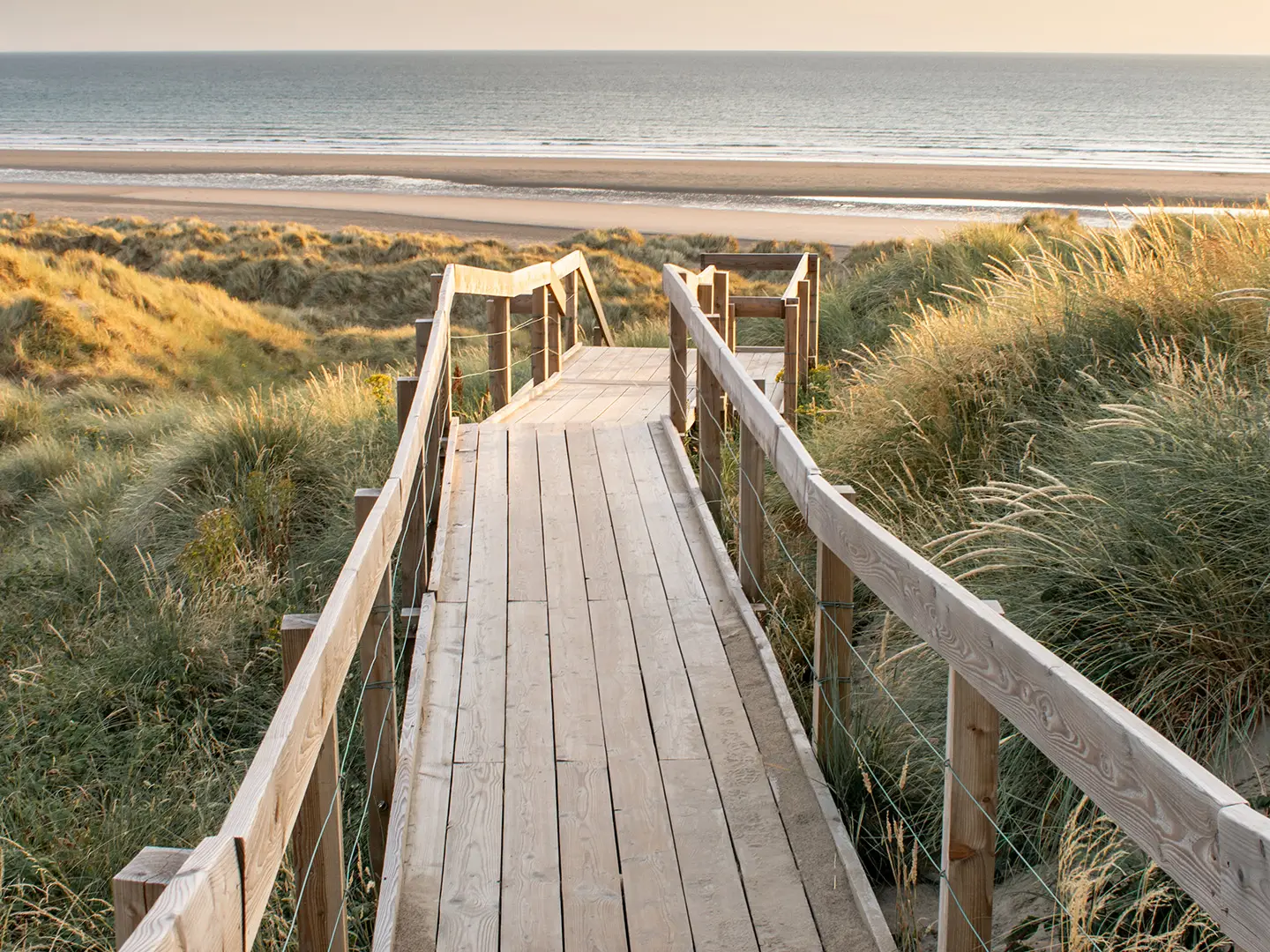
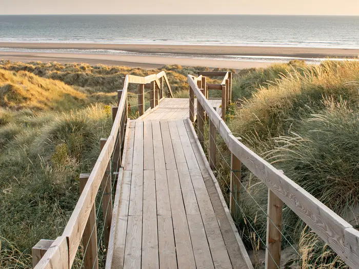
Image by Rhodri
i
Image by Rhodri The Ceredigion Coast Path is a 96 km / 60 mile waymarked traverse of Cardigan Bay, linking Cardigan (Aberteifi) on the Teifi estuary with Ynyslas beside the Dyfi estuary. It suits reasonably fit walkers looking for a week-long coastal journey with real scenery, regular settlements and practical public-transport options.
This is a named section of the wider Wales Coast Path, but it has a strong identity of its own. The route moves between high cliff-tops, wooded ravines, sandy coves, storm beaches, harbour towns and the shifting dunes of the Dyfi National Nature Reserve.
Much of the southern half has the feel of a wilder Heritage Coast, with Mwnt, Llangrannog, Cwmtydu, Ynys Lochtyn and New Quay (Ceinewydd) providing many of the most memorable stretches. Wildlife is a major part of the walk: Cardigan Bay is known for bottlenose dolphins, with grey seals, harbour porpoises and choughs also part of the coastal experience.
Do not judge the walk by its modest high point of 156 m. The path gains around 3,250 m in total, mostly through repeated short, steep climbs and descents in and out of coves and valleys, with exposed cliff sections and many flights of steps.
This guide covers stages, daily planning, accommodation, food, transport, terrain and the common mistakes that can make this route harder than expected.
Stage-by-Stage Guide
Stage 1: Cardigan (Aberteifi) to Aberporth — 19 km
This is one of the longer official stages, but the walking is mostly easy to moderate until the more committing clifftop section beyond Mwnt. The route starts beside the bronze otter sculpture at the old bridge over the River Teifi, then follows the north side of the estuary through farmland and coastal edge towards Gwbert.
The first section to Gwbert is relatively straightforward, passing the Patch, Pen yr Ergyd and views towards Cardigan Island, a Wildlife Trust nature reserve off the headland. Around Gwbert, the path passes the headland area near Cardigan Golf Club and the Cliff Hotel before turning towards the next stretch.
Between Gwbert and Mwnt there is currently a significant amount of road walking, with the route turning inland towards Ferwig before returning to the coast. Follow the waymarks carefully here, as this is not a simple cliff-edge traverse.
Mwnt is the main highlight of the day: a sandy cove below Foel y Mwnt, with the whitewashed Eglwys y Grog (Church of the Holy Cross), a 14th-century sailors’ chapel, nearby. This is also a good area for watching for dolphins, grey seals, harbour porpoises and choughs.
North of Mwnt the walk becomes more remote and more scenic, using a clifftop route before leaving the immediate coast to follow the wooded glacial meltwater channel of Cwm Gwrddon. Near Aberporth, the path is forced inland to skirt the Ministry of Defence base on the hilltop, so do not expect to stay on the very edge of the coast all the way to the village.
Aberporth is a useful first overnight stop, with B&Bs, guesthouses, holiday parks and campsites. The village has cafes, shops and pubs, making it a good place to restock after a long first day.
The TrawsCymru T5 bus serves Aberporth on the Aberystwyth–Cardigan corridor, with a year-round Sunday service added in 2025 on top of the daily Monday–Saturday service. This makes the stage practical for section-walkers as well as through-hikers, but current timetables and days of operation should be checked before travelling.
Key warnings for this stage are the road walking between Gwbert and Mwnt and the inland diversion around the MoD base near Aberporth. The route is waymarked, but these inland sections make it important to pay attention at junctions rather than simply following the coastline.
Stage 2: Aberporth to Llangrannog — 9 km
This is a short stage on paper, but it is one of the toughest relative to its distance. The day links several classic Ceredigion Heritage Coast beaches, with repeated steep climbs and descents packed into a compact section.
The opening walk from Aberporth to Tresaith is the easiest part of the day. It uses an all-weather surfaced clifftop path, with the southern half described as wheelchair friendly, and gives wide views back along the coast.
Tresaith is known for its waterfall, where the River Saith drops over the soft cliff onto the rock-strewn shore. From here the route becomes harder, climbing inland because of the steep coastal slope and gaining height before Penbryn.
Penbryn is a National Trust-managed beach and a useful scenic pause, but the hardest walking still follows. The final stretch to Llangrannog includes sharp climbs and descents around Traeth Bach, then rises towards the ramparts of the Iron Age fort at Castell-bach before descending into the village.
Food and drink options are limited compared with the bigger harbour towns. Tresaith may have seasonal facilities, and Llangrannog has a pub and a small cafe, but walkers should carry enough food and water from Aberporth, especially outside the main season.
Llangrannog is small and accommodation is limited. There are some B&B, guesthouse, campsite and holiday cottage options in and around the village, but this is a place to book well ahead rather than rely on finding a bed at short notice.
Public transport access is weaker here than at Aberporth, New Quay or Aberaeron. The TrawsCymru T5 serves the wider coast between Cardigan and Aberystwyth, but services into Llangrannog itself are limited and can be seasonal or infrequent; a taxi may be needed. This should be checked before travelling.
Many walkers combine this stage with Stage 3 to make a longer Aberporth to New Quay day, or use Llangrannog as a lunch stop rather than an overnight. That creates a demanding day, so the decision should be based on fitness, pack weight, weather and accommodation availability.
Stage 3: Llangrannog to New Quay (Ceinewydd) — 15 km
This is one of the most spectacular stages of the Ceredigion Coast Path, with sustained cliff walking, deep coves and some of the route’s strongest coastal character. It is moderate rather than technically difficult, but the terrain is exposed and the effort is steady.
Leaving Llangrannog, the path climbs onto steep-sided coastal slopes and in places feels cut directly into the cliff face. An inland alternative through a wooded cwm is available for some sections and can be useful in poor weather.
The standout landmark is Ynys Lochtyn, a rocky tidal promontory and islet with the Iron Age hillfort of Pendinas Lochtyn. This National Trust-managed area is one of the most photographed viewpoints on the route, with a strong sense of height above the sea.
The route also passes Cilborth Beach and Traeth yr Ynys, with the curved ramparts of Castell Bach visible in the wider landscape. At Cwmtydu, a quiet coastal hamlet, sea caves, a former limekiln and seal-watching opportunities make it a natural break point.
North of Cwmtydu the route continues through strong coastal geology, especially around Cwm Soden, where folded rock formations are a feature. Birds Rock, a former coastguard lookout, is another major viewpoint and a good place to look for dolphins and seabirds in suitable conditions.
New Quay is a strong overnight stop, with B&Bs, guesthouses, hotels, self-catering accommodation and a campsite at Bay Holiday Park. It also has pubs, cafes, shops and fish and chips, plus dolphin-watching boat trips from the harbour.
The TrawsCymru T5 bus serves New Quay, making it one of the easier stage ends for public transport. This is useful for walkers splitting the route, shortening a wet-weather day or using Aberystwyth as a base.
The main warnings are exposure and path width. Some sections use narrow cliff paths with significant drops, and strong winds can make balance difficult. This stage is best saved for clear, settled weather where possible.
Stage 4: New Quay (Ceinewydd) to Aberaeron — 11 km
This is a shorter and generally easier stage, though it still has some steep ground and exposed clifftops. It begins from New Quay’s harbour area, then uses a mix of inland and coastal walking before the attractive finish at Aberaeron.
At New Quay Head, the natural harbour and stone quay set the character of the start. A statue on the seafront marks the Wales Coast Path’s halfway point, though this Ceredigion section continues north to Ynyslas.
Near Llanina, the route passes places associated with Dylan Thomas, including the area around his wartime home at Majoda. There is also a 6th-century church ruin at Llanina, adding historical interest before the path continues towards Cei Bach.
The route then passes the small cove of Cei Bach and continues towards Cwm Buwch, where the Afon Drywi drops to a waterfall above an inaccessible beach. Other features on the way include Gilfach yr Halen and the hill-top church at Henfynyw, on the approach to Aberaeron.
There is a tide-dependent option near the start of the stage. At low tide, it is possible to follow the beach to Llanina and Cei Bach Beach before turning inland to the high-tide route at Pont Llanina car park; at high tide, the lane route passes Majoda. Tide times should be checked before setting off.
Aberaeron is one of the easiest and most comfortable overnight stops on the route. The planned Regency harbour town has an excellent range of B&Bs, guesthouses, hotels, self-catering accommodation, cafes, pubs, restaurants, shops and a supermarket.
The TrawsCymru T5 bus serves Aberaeron. This makes the stage straightforward to access by public transport and a practical place to build in a rest, resupply or shorter walking day.
Navigation is generally clear and waymarked, but livestock may be present on the clifftops and there are steep sections despite the modest distance. The key planning issue is the tide-dependent beach option near New Quay.
Stage 5: Aberaeron to Llanrhystud — 12 km
This is the gentlest official stage and a marked contrast to the steeper Heritage Coast sections further south. The walking is mostly along soft, low clifftops and coastal flats, with one more noticeable rise over Graig Ddu.
The first part to Aberarth is flat and easy. Aberarth has a shipbuilding history, and old fish traps can be visible at low tide.
Beyond Aberarth, the route continues along soft clifftops towards Llanon, gradually gaining height over Graig Ddu. In clear conditions this gives views north towards Aberystwyth and, beyond, towards the mountains of north Wales.
Around Llanon, medieval field patterns known as slangs are part of the landscape. Between Llanon and Llanrhystud the route passes the Craig-las Limekilns, a line of six kilns associated with lime-loving flora, and the church at Llansanffraid dedicated to Non, St David’s mother, and St Bridget.
Food and water are limited on this stage. Llanrhystud has a village pub, but opening times should be checked, and walkers should carry what they need from Aberaeron.
Accommodation at Llanrhystud is very limited, mainly a small number of B&B options. If no suitable bed is available, walkers often need to use public transport to return to Aberaeron or continue onwards towards Aberystwyth.
The TrawsCymru T5 serves the main road near Llanon and Llanrhystud, giving a practical public transport fallback. This is still one of the more limited stage ends for accommodation, so it needs more advance planning than Aberaeron or Aberystwyth.
Navigation is straightforward and the route is well waymarked, but the soft cliffs are actively eroding and may be undercut. Stay on the marked path and do not approach the cliff edge for photographs or short cuts.
Stage 6: Llanrhystud to Aberystwyth — 17 km
This is the most serious official stage: longer, more isolated and much more committing than the previous day. There are no settlements, services or easy bail-out points between Llanrhystud and Aberystwyth, so it should be treated as a full coastal hill day rather than a simple walk into town.
The terrain changes abruptly into steep, exposed Heritage Coast walking. The path crosses the Penderi Cliffs nature reserve, where hanging sessile oak woodland is stunted by sea winds and the cliffs support seabirds including cormorants, choughs, kestrels, peregrine falcons and ravens.
The walking is repeatedly undulating, with cliff-edge exposure and short sections of narrow path above large drops. The descent on steps to Wallog is particularly demanding and comes before the final approach towards Aberystwyth.
Wallog is a memorable point on the stage, with a solitary house below the cliffs and views of Sarn Cynfelyn, a pebble causeway or glacial moraine extending far into Cardigan Bay. After Wallog, the route gradually opens towards Aberystwyth, with the promenade eventually coming into view.
There is no food, water or shelter on the route between Llanrhystud and Aberystwyth. Carry enough water, lunch, extra snacks and weather protection from the start of the day.
Aberystwyth is the largest town on the route and has the best range of services. Accommodation includes hotels, B&Bs, guesthouses, self-catering, hostels and campsites, with extensive food options, supermarkets, pubs, cafes and takeaways.
Transport access at the end is excellent. Aberystwyth has a station on the Cambrian Line, with rail links towards Shrewsbury and Birmingham, and is also served by the TrawsCymru T5 bus and local AberBus services.
This stage should not be underestimated. Check the forecast before starting, avoid setting out in severe wind, and allow enough daylight for slow progress on the exposed sections around Penderi and the descent to Wallog.
Stage 7: Aberystwyth to Ynyslas — 16 km
The final stage has two very different halves: steep cliff walking from Aberystwyth to Borth, then flat beach, dune and embankment walking towards the Dyfi estuary. It is a varied finish, but the opening section is still physically demanding.
From Aberystwyth the path climbs towards Craig Glais, better known as Constitution Hill. The cliff railway and Camera Obscura at the top are optional side interests, but walkers continuing the stage follow the coastal path north towards Clarach.
The first subsection to Clarach Bay is short but uses cliff terrain. Clarach is a popular summer beach with a holiday park, after which the route continues over more strenuous ground towards Borth.
The Clarach to Borth section includes several big climbs and is the hardest part of the day. Near Borth, Craig y Delyn, or harp rock, gives a dramatic final piece of cliff scenery before the terrain changes completely.
Borth is a useful stop before the last flat section. It has pubs, cafes and small shops, plus accommodation including B&Bs, holiday parks and campsites.
North of Borth the route becomes flat, using beach sections and the flood embankment of the River Leri beside Cors Fochno, also known as Borth Bog. Groynes on the beach can force short inland route-finding, so it is still worth watching the waymarks rather than assuming the beach is continuous.
This final area is rich in natural interest. The route skirts Cors Fochno, one of Britain’s largest and best-preserved lowland raised peat bogs, and reaches the dunes of the Dyfi National Nature Reserve at Ynyslas. At low tide, the submerged prehistoric forest on the Borth–Ynyslas beach may be visible, with ancient tree stumps preserved in peat.
At Borth, the Wales Coast Path and the Ceredigion Coast Path diverge: the wider Wales Coast Path heads inland around Cors Fochno to find a crossing of the Dyfi, while the Ceredigion Coast Path continues to the estuary and dunes at Ynyslas. The official finish is the Ynyslas war memorial beside the Dyfi estuary.
Food and water should be carried for the Aberystwyth to Borth cliff section. Borth has facilities, while Ynyslas itself is very small and the Natural Resources Wales visitor centre has limited seasonal facilities.
Borth and Ynyslas are served by the Cambrian Line, giving rail access back to Aberystwyth and onward connections. Many walkers finish at Ynyslas and stay in Borth or return to Aberystwyth rather than trying to overnight at Ynyslas itself.
Navigation is generally clear, but the route change at Borth matters. Follow the signs for the Ceredigion Coast Path finish at Ynyslas rather than continuing automatically on the wider Wales Coast Path line around the Dyfi.
Recommended Itinerary
The most balanced way to walk the Ceredigion Coast Path is the standard seven-day schedule used by Ceredigion County Council and Discover Ceredigion. It keeps daily distances moderate, gives time for the steep cliff sections, and places most overnight stops in villages or towns with at least some services.
South to north, from Cardigan (Aberteifi) to Ynyslas, is the usual direction. The route can be walked north to south, but accommodation and transport planning should still be built around the same stage settlements.
Standard 7-day itinerary
| Day | From | To | Approx. distance | Why this stage makes sense | Services/accommodation notes |
|---|---|---|---|---|---|
| 1 | Cardigan (Aberteifi) | Aberporth | 19 km / 12 miles | This is the longest official stage and a demanding opener, but it gets the southern cliff section done in one day and reaches a practical overnight village. The route passes Gwbert and Mwnt, with Eglwys y Grog and the conical hill above the cove. | Cardigan has the strongest start-of-walk services. Aberporth has a pub, café, accommodation and T5 bus access. Book ahead in summer, as this is a common first-night stop. |
| 2 | Aberporth | Llangrannog | 9 km / 5.4 miles | The shortest stage, but not a wasted day: the coast through Tresaith and Penbryn is steep, scenic and slower than the mileage suggests. It also avoids turning the next section to New Quay into too big a day for less experienced walkers. | Tresaith has a beach and inn. Penbryn beach has no facilities at the beach itself. Llangrannog is a small village with pubs and limited B&B/guesthouse choice, so accommodation should be booked early. |
| 3 | Llangrannog | New Quay (Ceinewydd) | 15 km / 9.4 miles | One of the strongest walking days on the route, with high cliff scenery, Cwmtydu, Cwm Soden, Ynys Lochtyn and Birds Rock before New Quay. The distance is manageable after the shorter second day. | Cwmtydu is a tiny hamlet with a seasonal café. New Quay has a good choice of pubs, cafés, restaurants and B&Bs, and is a practical resupply and rest stop. T5 bus access is useful if section-walking. |
| 4 | New Quay (Ceinewydd) | Aberaeron | 11 km / 6.6 miles | A shorter day after the tougher Heritage Coast stages. The route is popular with day walkers and gives time to enjoy Aberaeron rather than arriving late. | Aberaeron has the best range of food, accommodation and shopping between Cardigan and Aberystwyth, including a good supermarket. It is a sensible place to build in an easier afternoon. |
| 5 | Aberaeron | Llanrhystud | 12 km / 7.4 miles | This is the gentlest official section, with softer cliffs and coastal flats, making it a natural recovery day before the longer approach to Aberystwyth. | Aberarth is passed en route and has a pub. Llanrhystud is a quieter village with a pub, basic facilities and T5 bus access. Some walkers continue about 3.4 km further to Llanon for slightly more accommodation choice. |
| 6 | Llanrhystud | Aberystwyth | 17 km / 10.6 miles | A longer and more dramatic day, including the Penderi Cliffs SSSI and the approach into the route’s main town. Saving this section for a full day is sensible, especially in poor weather. | Aberystwyth has the widest choice of accommodation, restaurants, pubs, supermarkets and transport on the route. It has a Cambrian Line railway station and T5 bus access, making it the easiest place to pause, finish early or restart. |
| 7 | Aberystwyth | Ynyslas | 16 km / 9.8 miles | The final stage combines undulating coast north of Aberystwyth with the approach through Borth and the Ynyslas dunes to the Dyfi estuary. It is a proper final walking day rather than a short stroll to the finish. | Borth has B&Bs, a pub and a Cambrian Line station. Ynyslas itself is quiet, with little in the way of facilities at the end, so plan onward transport or return to Borth. The 512 bus and Cambrian Line cover the Aberystwyth–Borth–Ynyslas area; check current timetables before travelling. |
Faster 5-day itinerary
A five-day schedule suits fit walkers who are comfortable with longer coastal days, repeated ascent and less time in the smaller villages. It works particularly well for walkers using public transport or basing themselves around Aberystwyth, but it gives fewer options to shorten a day once committed.
| Day | From | To | Approx. distance | Why this stage makes sense | Services/accommodation notes |
|---|---|---|---|---|---|
| 1 | Cardigan (Aberteifi) | Aberporth | 19 km / 12 miles | Keeps the standard long opening stage intact and reaches a village with accommodation and bus access. | Aberporth is the practical overnight stop. Book ahead in peak season. |
| 2 | Aberporth | New Quay (Ceinewydd) | 24 km / 15 miles | Combines the short Aberporth–Llangrannog stage with the spectacular Llangrannog–New Quay section. This is the hardest day of the faster plan because the terrain is repeatedly steep. | Llangrannog is passed rather than used as an overnight stop. New Quay has good evening food and accommodation choice, plus T5 bus access. |
| 3 | New Quay (Ceinewydd) | Llanon | Around 14–15 km / 9 miles | Links New Quay, Aberaeron and the gentler coast northwards without stopping at Aberaeron. This creates a more even split before the long approach to Aberystwyth. | Aberaeron is the key mid-day resupply point. Llanon accommodation and food options are more limited than Aberaeron or Aberystwyth; this should be checked before booking. |
| 4 | Llanon | Aberystwyth | Around 20 km / 12 miles | A longer day over the more dramatic northern cliff section, finishing in the route’s main transport and accommodation hub. | Aberystwyth has the best services on the trail and is the most forgiving place to arrive late. T5 bus and Cambrian Line rail connections are available. |
| 5 | Aberystwyth | Ynyslas or Borth | 16 km / 9.8 miles to Ynyslas | Completes the northern section in one day, with the option to finish at the official end at Ynyslas or use Borth for transport and accommodation. | Ynyslas has limited facilities at the finish. Borth has accommodation and a Cambrian Line station, making it the practical end point for many walkers after visiting the war memorial at Ynyslas. |
Slower 9–10 day itinerary
A slower plan suits walkers who want shorter cliff days, more time for wildlife watching, or more flexibility around weather. It is also sensible for anyone carrying a full pack without luggage transfer.
The exact splits depend heavily on accommodation availability in the smaller places. Tresaith, Penbryn, Cwmtydu, Aberarth and Llanon can help break up the route, but services are limited and seasonal in some of these places. Check official mapping and accommodation before committing to overnight stops.
| Day | From | To | Approx. distance | Why this stage makes sense | Services/accommodation notes |
|---|---|---|---|---|---|
| 1 | Cardigan (Aberteifi) | Aberporth | 19 km / 12 miles | Even on a slower schedule, this remains the most straightforward first-stage split unless accommodation is arranged elsewhere on the southern section. | Aberporth has pub, café, accommodation and T5 bus access. |
| 2 | Aberporth | Tresaith or Penbryn area | Check official mapping before booking | Splits the short but steep Aberporth–Llangrannog section and gives more time on the Heritage Coast. | Tresaith has an inn. Penbryn beach itself has no facilities; any overnight plan here must be arranged carefully in advance. |
| 3 | Tresaith or Penbryn area | Llangrannog | Check official mapping before booking | Keeps the day short and avoids rushing the high cliffs and isolated beaches before Llangrannog. | Llangrannog has pubs and limited B&B/guesthouse accommodation. Book early. |
| 4 | Llangrannog | Cwmtydu | Check official mapping before booking | Breaks the spectacular Llangrannog–New Quay stage and leaves time around Ynys Lochtyn and the smaller coves. | Cwmtydu is very small and has a seasonal café. Accommodation and food arrangements should be checked before travelling. |
| 5 | Cwmtydu | New Quay (Ceinewydd) | Check official mapping before booking | Gives a shorter approach into New Quay, with time around Birds Rock and the harbour town. | New Quay has good food, pub and B&B choice, and T5 bus access. |
| 6 | New Quay (Ceinewydd) | Aberaeron | 11 km / 6.6 miles | A short, useful transition day into one of the best service towns on the route. | Aberaeron is a strong place for food, accommodation and resupply. |
| 7 | Aberaeron | Aberarth, Llanon or Llanrhystud | Check official mapping before booking | Allows a flexible split across the gentler middle-northern coast before the more demanding approach to Aberystwyth. | Aberarth has a pub. Llanon may offer slightly more accommodation choice than Llanrhystud, while Llanrhystud has a pub, basic facilities and T5 bus access. |
| 8 | Aberarth, Llanon or Llanrhystud | Aberystwyth | Check official mapping before booking | Keeps the Penderi Cliffs and the approach into Aberystwyth as a contained day rather than forcing a long push from Aberaeron. | Aberystwyth has the route’s best accommodation, food, shops and onward transport. |
| 9 | Aberystwyth | Rest day or local day | — | A rest day is most useful here because Aberystwyth has full services and transport. It also gives a weather buffer before the final stage. | Useful for laundry, resupply, transport adjustments or shortening the trip if needed. |
| 10 | Aberystwyth | Ynyslas, returning or continuing via Borth | 16 km / 9.8 miles to Ynyslas | Completes the route without rushing the final coast, Borth and the Dyfi National Nature Reserve dunes. | Finish facilities at Ynyslas are limited. Borth is the practical rail and accommodation point near the end. |
Planning the Route
How many days to allow
The cleanest way to plan the Ceredigion Coast Path is as a seven-day walk, using the official stage breakdown. Each stage ends in a town or village with some combination of accommodation and public transport, so the route does not require awkward off-trail transfers or invented stopping points.
A five-day schedule is feasible for fit walkers who are comfortable with repeated climbing and longer coastal days. It is not the best choice for anyone wanting short days, wildlife-watching time, or flexibility in poor weather.
An eight-night itinerary is more comfortable, especially in summer when hot, windy or wet conditions can slow progress on the cliff paths. Self-guided operators commonly offer 6, 7 or 8-night versions, with some itineraries stretching further for a gentler pace.
| Pace | Typical use | Notes |
|---|---|---|
| 5 walking days | Fast, fit walkers | Uses longer linked stages; public-transport planning becomes more important. |
| 7 walking days | Standard itinerary | Follows the official sections and gives the simplest overnight structure. |
| 8+ nights | Easier pace | Better for shorter days, rest time, photography, wildlife watching and less pressure in bad weather. |
The natural stage structure
The settlements define the walk. Cardigan (Aberteifi), Aberporth, Llangrannog, New Quay (Ceinewydd), Aberaeron, Llanrhystud, Aberystwyth and Borth/Ynyslas are the practical planning points, with the official stages built around them.
The only notably short official day is Aberporth to Llangrannog, at about 5.4 miles / 9 km. This can work well as a deliberately easy day, but many walkers combine it with either the previous or following section.
| Official stage | Approx. distance | Planning comment |
|---|---|---|
| Cardigan to Aberporth | 12 miles / 19 km | One of the longer days; do not underestimate the early coastal undulations. |
| Aberporth to Llangrannog | 5.4 miles / 9 km | Short and useful as a light day, or easy to merge with another stage. |
| Llangrannog to New Quay | 9.4 miles / 15 km | Often combined with Aberporth to Llangrannog for a longer day of about 14.8 miles. |
| New Quay to Aberaeron | 6.6 miles / 11 km | A shorter harbour-to-harbour stage. |
| Aberaeron to Llanrhystud | 7.4 miles / 12 km | Straightforward to plan, but accommodation choice is more limited at the end. |
| Llanrhystud to Aberystwyth | 10.6 miles / 17 km | One of the bigger days and best not left to a late start. |
| Aberystwyth to Ynyslas | 9.8 miles / 16 km | The final section uses Borth/Ynyslas transport planning rather than a large town finish. |
Intermediate places such as Mwnt, Tresaith, Penbryn, Cwmtydu, Llanon and Clarach are useful for breaking up the route on the ground, but should not be assumed to provide reliable overnight options for every itinerary. Accommodation in these smaller places may be limited or seasonal.
Booking accommodation
Accommodation is the main constraint on this route. The larger stops — Cardigan, New Quay, Aberaeron and Aberystwyth — give the broadest choice, while smaller overnight points such as Llangrannog and Llanrhystud can book up quickly.
For July and August, booking three to six months ahead is sensible, especially where the itinerary depends on a specific village. Coastal Ceredigion is busy with UK holidaymakers in summer, and a single full village can disrupt an otherwise simple schedule.
B&Bs, guesthouses, inns, farmhouse stays, campsites and holiday parks all appear along the route. Wild camping is not generally permitted, so camping itineraries still need booked sites or agreed overnight stops.
The Walkers Welcome scheme operates in the area, and many suitable places understand the needs of coast-path walkers, including drying space, packed lunches and luggage storage. Discover Ceredigion publishes a downloadable accommodation list arranged south to north, which is useful for independent planning.
Walkers wanting luggage transfer should normally use a self-guided operator such as Celtic Trails, Encounter Walking Holidays, Contours or similar providers. These packages usually arrange accommodation and baggage movement together; summer departures should be booked well ahead, often six months or more in advance.
Direction of travel
Most walkers go south to north, from Cardigan to Ynyslas. This gives a clear link from the Pembrokeshire Coast Path at the Teifi and leaves Aberystwyth, Borth and the Cambrian Line close to the finish arrangements.
North to south is equally valid. It can suit walkers arriving by train to Borth or Aberystwyth and finishing in Cardigan, where the T5 bus gives onward public-transport options.
There is no permit, fee or booking requirement for the path itself. The Discover Ceredigion Challenge Certificate is optional and commemorative.
Shortening, extending and section hiking
This is a practical route to section-hike. The TrawsCymru T5 bus links Aberystwyth and Cardigan and serves major planning points including Cardigan, Aberporth, New Quay, Aberaeron, Llanrhystud and Aberystwyth; it runs daily, with a year-round Sunday service added in 2025. The Aberystwyth to Cardigan journey is roughly 1 hour 48 minutes, but current times and days should be checked before travelling.
The northern end is also well served by the Cambrian Line at Aberystwyth and Borth, with the 512 bus covering the Aberystwyth–Borth–Ynyslas section (Monday–Saturday). The Cardi Bach 552, a seasonal coastal shuttle that once linked Cardigan, Mwnt, Aberporth, Llangrannog, Cwmtydu and New Quay, has been withdrawn, so it should not be relied on; any reinstatement should be checked before travelling.
Aberystwyth is the most useful base for section walking because it has the widest accommodation choice, a railway station and T5 connections. Aberaeron can work well for the middle-southern sections, while Cardigan is the obvious base for the southern end.
Timetables are central to any section-hiking plan. Sunday and off-season frequencies are lighter than weekdays and rural services can change, so use Traveline Cymru before booking accommodation and again before travelling.
The route is easy to extend south by continuing across the Teifi at St Dogmaels onto the Pembrokeshire Coast Path, or north along the next section of the Wales Coast Path. A longer trip combining the northern Pembrokeshire coast with Ceredigion is a common way to build a multi-week coastal walk.
Navigation and route finding
The path is waymarked with the Wales Coast Path coast-and-sea graphic waymark. In settled areas and on clear cliff-top sections, route finding is usually straightforward.
Do not rely on waymarks alone in poor visibility, bad weather or where the path crosses lanes, dunes, woodland or developed edges. A GPS app or downloaded GPX track is useful, particularly on exposed cliff sections and at the northern dunes near Ynyslas.
Useful Ordnance Survey coverage includes Explorer 198 for Cardigan and New Quay, Explorer 199, Explorer 213 for Aberystwyth and Cwm Rheidol, and OL35 for the southern end. Map editions should be checked before relying on them.
Path closures and diversions are a real planning item on any coast path. Check Ceredigion County Council Coast and Countryside updates before departure, especially after storms or prolonged wet weather.
Weather, food and water planning
The west Wales coast is exposed, and the walking can feel much harder than the daily mileage suggests. Strong westerly winds, rain, low cloud and slippery steps can all slow progress on the cliff sections.
Check the Met Office forecast daily and keep a margin in the schedule for poor conditions. Stages 1, 3 and 6 are the longest and should not be underestimated, particularly with a full pack.
Food and water planning is mostly about not assuming there will be facilities between villages. Harbour towns and larger villages are the reliable resupply points, while longer cliff and cove sections may have no services for several hours.
Carry enough water for the full stage, plus food for the day where opening times or seasonal closures could affect cafés and shops. This is especially important outside peak summer and on routes that use smaller overnight stops.
What to prioritise before setting off
- Accommodation: book the smaller villages first, then build the rest of the itinerary around those nights.
- Transport: check T5, 512 and train times with Traveline Cymru; Sunday and off-season planning needs particular care.
- Stage pacing: allow for repeated short climbs and descents rather than judging days by mileage alone.
- Weather: check the forecast daily and be prepared for exposed cliff walking.
- Navigation: carry maps or offline digital mapping, not just waymarks.
- Food and water: do not depend on facilities between stage towns and villages.
- Path conditions: check Ceredigion County Council updates for closures or diversions before travelling.
Towns, Villages and Overnight Stops
Accommodation is regular but uneven on the Ceredigion Coast Path. Cardigan (Aberteifi), Aberaeron and Aberystwyth have the most dependable choice; Llangrannog and Llanrhystud are the places most likely to constrain an itinerary.
For July and August, book all overnight stops well ahead — 3–4 months is sensible for the smaller villages. Wild camping is not generally permitted, so do not rely on pitching informally to solve a full accommodation night.
Cardigan (Aberteifi)
Cardigan is the southern trailhead, with the official start at the bronze otter sculpture beside the old bridge over the River Teifi. It is also where the route links with the Pembrokeshire Coast Path, which crosses the Teifi to St Dogmaels.
This is the best-served town before Aberystwyth and a strong place to stay the night before starting. Accommodation includes hotels, guesthouses and B&Bs, with options such as Albion Aberteifi, accommodation within Cardigan Castle, and the Gwbert Hotel nearby.
Food and supplies are straightforward here. Cardigan has the widest range of shops, pubs, cafés and restaurants in the southern half of the route, plus a supermarket, making it the best place to buy anything missing before setting out.
There is no railway station in Cardigan. The TrawsCymru T5 bus links Cardigan with Aberystwyth and serves several coastal communities on the route; it runs daily, and a year-round Sunday service was added in 2025, though days and times should be checked before travelling. Local taxis are also available.
Gwbert
Gwbert is a small village roughly 3 km north of Cardigan, above the Teifi estuary. For most walkers it is a waypoint rather than a planned overnight stop.
Accommodation for thru-hikers is limited, though the Gwbert Hotel has rooms and bar food, and there are self-catering cottages in the area. There is no need to build a standard itinerary around Gwbert unless accommodation in Cardigan or Aberporth dictates it.
Its main value on foot is as an early coastal viewpoint, with good views across the estuary and a known dolphin-watching position.
Mwnt
Mwnt is not a village and is not a practical overnight stop. There is no accommodation, pub or shop at the cove.
It is still one of the key stops on the first stage. The path passes the National Trust-managed cove and Eglwys y Grog, the whitewashed Church of the Holy Cross above the beach. Toilets and a small car park are available.
Plan Mwnt as a rest or lunch stop, not a resupply point. It is also a good place to watch for seals, choughs and dolphins when conditions are suitable.
Aberporth
Aberporth is the standard end of the first official stage from Cardigan. It is a coastal village on the Heritage Coast with two beaches and enough facilities to work well as an overnight stop.
Accommodation is usable but not abundant. There is pub/B&B accommodation, holiday cottages and some options used by self-guided walking operators, but beds should be booked ahead in summer.
Food options are better than the village size suggests. Walkers will find pubs, including The Ship Inn above Dyffryn beach on the coast path, a beach-side bar, cafés, fish and chips, Indian and Chinese takeaway, a pharmacy, a village food store and a laundrette.
Aberporth is on the T5 bus route between Cardigan and Aberystwyth. It is a practical first exit point if the opening day has taken longer than expected.
Tresaith
Tresaith sits between Aberporth and Llangrannog and can be useful for walkers wanting shorter stages or an alternative to a full Llangrannog stop. It is a small beach village, so capacity is limited.
The main walker-friendly overnight option is The Ship Inn, directly above the beach on the coast path, with en-suite rooms and food. Otherwise, the area is mainly self-catering cottages.
There is a beach shop, but Tresaith should not be treated as a major resupply stop. Its practical appeal is the on-route pub, food and location, plus the beach waterfall where the stream drops onto the sand.
Penbryn
Penbryn is a very small hamlet associated with the National Trust beach below it. It is not a practical standard overnight stop for most thru-hikers.
There is no pub or shop on the coast, and accommodation is mainly self-catering cottages in the wider area. Walkers usually pass through between Tresaith and Llangrannog rather than stopping for the night.
Use Penbryn as a scenic break point rather than a service stop. If planning to stay nearby, arrangements need to be made well in advance and checked carefully against walking distances.
Llangrannog
Llangrannog is the standard end of the second official stage and one of the most attractive overnight stops on the route. It sits in the Hawen valley, with two sandy beaches and a compact village centre.
Accommodation is limited for such a popular place. The main practical options are The Ship Inn by the beach and the Pentre Arms Hotel, both offering rooms and food, alongside self-catering cottages.
Food is available at the pubs, The Patio Café, the Beach Hut café and the beach shop. There is no supermarket, so arrive with any specific supplies already bought.
The T5 bus passes nearby rather than through the heart of the village. In July and August, advance booking is essential because family holiday demand competes directly with walkers for rooms.
Cwmtydu
Cwmtydu is a tiny cove hamlet south of New Quay. It is a quiet, useful stopping point during the walking day but not a standard overnight base.
There is a caravan and motorhome site, but very little for walkers needing a conventional bed, meal and resupply. Do not rely on Cwmtydu for shops or pub food.
The cove has an old lime kiln and a history as a smugglers’ landing point. It works best as a picnic or rest stop before continuing towards New Quay.
New Quay (Ceinewydd)
New Quay is the standard end of the third official stage and one of the best mid-route hubs. It is a harbour town with more services than the smaller coves and villages to the south.
Accommodation is reasonable for its size but still finite. Options include The Penwig Hotel, The Black Lion, the Pepper Pot Bar & Grill’s self-contained holiday flat, plus self-catering. Book ahead in the main holiday season.
Food choice is strong for a small town, with pubs, cafés, fish and chips near the pier, Café Mariners and The Pepper Pot Bar & Restaurant. There are also convenience stores and a small supermarket.
New Quay is on the T5 bus route between Cardigan and Aberystwyth and is a useful mid-route access point. It is also the route’s best base for dolphin watching and boat trips in Cardigan Bay.
Aberaeron
Aberaeron is the standard end of the fourth official stage and one of the strongest overnight stops on the whole path. It is a planned Regency harbour town with a compact centre and good walker services.
Accommodation quality and choice are better here than in many of the smaller stops. Options include The Harbourmaster, The Monachty, Y Seler and multiple B&Bs.
Food is a particular strength. The Harbourmaster, The Stubborn Duckling, The Hive, The Monachty and quayside cafés give walkers a proper choice of evening meals, with seafood and local produce prominent.
There is a supermarket and general stores for resupply. Aberaeron is served by the T5 bus, but has no railway station.
Llanon
Llanon sits north of Aberaeron on the A487 coast road and is used in some shorter or public-transport-based itineraries. For the standard seven-stage route it is usually passed on the Aberaeron to Llanrhystud day.
It is small but functional. Facilities include the White Swan Inn, Llanon Premier Stores, a butcher, fish and chip takeaway, village hall, and a free car park with public toilets by the beach.
Llanon can work as an emergency or alternative overnight, but it is not a full-service walking base and bed stock is limited. Woodlands Caravan Park is nearby.
Llanrhystud
Llanrhystud is the standard end of the fifth official stage from Aberaeron. It is one of the more awkward overnight points on the route because accommodation is very limited.
Expect only a small number of B&B or farmhouse-style options, plus basic village services such as a pub and small shop. This is a place to book early rather than leave flexible.
The T5 bus serves the A487, which gives a useful fallback. If Llanrhystud is full, walkers commonly adjust by stopping at Llanon, continuing towards Aberystwyth, or using the bus to reach Aberystwyth and returning the next morning. This should be planned carefully before committing to stage distances.
Aberystwyth
Aberystwyth is the standard end of the sixth official stage and the main service hub of the Ceredigion Coast Path. It is the largest town on the route, with the best transport and the widest accommodation choice.
Accommodation is plentiful, including hotels, guesthouses, B&Bs, hostels and self-catering. Even here, booking ahead is wise during summer and university-related events.
Food and resupply are straightforward. Aberystwyth has restaurants, cafés, pubs, takeaways, supermarkets including Tesco and Morrisons, pharmacies, banks and gear shops.
Transport is excellent compared with the rest of the route. Aberystwyth station is on the Cambrian Line, with trains towards Machynlleth, Shrewsbury and Birmingham, and the T5 bus links back down the coast to Cardigan. It is the best place to start, finish, pause or rejoin a section hike.
Many walkers use Aberystwyth as a rest-day base. The promenade, castle ruins, National Library of Wales and cliff railway give useful low-effort options if staying an extra night.
Clarach
Clarach lies between Aberystwyth and Borth on the final section. The coast path passes through the bay, but it is not normally used as a thru-hiker overnight stop.
The main accommodation presence is holiday-park and caravan-style provision, including Clarach Bay Holiday Village. For most walkers, Aberystwyth or Borth will be more practical for beds, food and onward transport.
Borth
Borth is a linear seaside village north of Aberystwyth and the most practical place to stop before or after the Ynyslas finish. Some itineraries end here rather than at the war memorial at Ynyslas.
Accommodation is more limited than in Aberystwyth, with a youth hostel, holiday caravans, camping and some B&B or hotel provision. Many walkers either stay in Aberystwyth and use transport, or walk through to the official finish and return to Borth or Aberystwyth afterwards.
Food is basic but adequate, with cafés, fish and chip shops and pubs. It is not a major resupply or dining stop, so buy anything specific before leaving Aberystwyth.
Borth has a station on the Cambrian Line, with trains to Aberystwyth and onward connections. This makes it an excellent access point for the final day and a sensible fallback if weather or time prevents continuing to Ynyslas.
Ynyslas
Ynyslas is the northern terminus, with the finish at the war memorial beside the Dyfi estuary and the dunes of the Dyfi National Nature Reserve. It is a finish point, not an overnight village.
There is no accommodation at the trailhead itself. The nearest practical accommodation is in Borth, about 3 km south, or Aberystwyth, about 14 km south.
Facilities at the dunes include the Natural Resources Wales visitor centre, car park and toilets. The 512 bus connects Ynyslas and Borth with Aberystwyth, but times should be checked before travelling, especially if finishing late in the day.
Getting to the Start
The Ceredigion Coast Path starts in Cardigan (Aberteifi), beside the bronze otter sculpture by the old bridge over the River Teifi. Cardigan has no railway station, so most walkers arrive by rail to a nearby hub and then continue by bus or pre-booked taxi.
By train
There is no direct rail access to Cardigan. The former Cardigan railway closed in 1962, so the final approach is by bus, taxi or lift.
The most useful rail gateways are:
| Rail station | Usefulness for the start | Onward connection to Cardigan |
|---|---|---|
| Carmarthen | Best southern rail-and-bus option, especially from Cardiff and Swansea | Bus 460 from Carmarthen Railway Station to Cardigan via Newcastle Emlyn, around 97 minutes; Monday–Saturday (no Sunday service) — check current times |
| Aberystwyth | Best hub for walkers arriving on the Cambrian Line, and useful if leaving a car or finishing near Borth/Ynyslas | TrawsCymru T5 to Cardigan, around 1 hour 48 minutes; runs daily, with a lighter Sunday service — check current times before travelling |
| Fishguard Harbour | Useful for arrivals from the Stena Line ferry from Rosslare, and for some rail journeys from the south | TrawsCymru T5 north to Cardigan |
| Clynderwen | One of the closest rail stations by distance, about 19 miles from Cardigan | Onward taxi or local transport planning required; This should be checked before travelling. |
Aberystwyth is often the simplest public-transport hub for independent walkers. Transport for Wales runs the Cambrian Line from Shrewsbury to Aberystwyth, with connections from Birmingham New Street. There is no direct London–Aberystwyth train; London journeys normally involve changing via Birmingham New Street or Shrewsbury and take roughly 4.5–5 hours in total.
Carmarthen is a practical alternative if travelling from South Wales. It is served by trains from Cardiff Central and Swansea, and the 460 bus starts at Carmarthen Railway Station, giving a straightforward rail-to-bus transfer into Cardigan.
By bus
The key service for the start is TrawsCymru T5, which runs on the Haverfordwest–Fishguard–Cardigan–New Quay–Aberaeron–Aberystwyth corridor. It is the main public-transport spine for the Ceredigion Coast Path and is useful both for reaching Cardigan and for breaking or rejoining the walk later.
Important T5 points for planning:
- Aberystwyth to Cardigan takes about 1 hour 48 minutes.
- The service runs daily, with a year-round Sunday service added in 2025; Sunday frequencies are lighter, so check current times before relying on them.
- It serves key trail towns including Cardigan, New Quay (Cei Newydd), Aberaeron and Llanrhystud; some services also serve Aberporth.
- Timetables should be planned through Traveline Cymru before booking accommodation.
From Carmarthen, bus 460 runs from Carmarthen Railway Station to Cardigan via Newcastle Emlyn, taking around 97 minutes. It is a useful option for walkers arriving by train from Cardiff or Swansea, and runs Monday to Saturday with no Sunday service. Current times and days should be checked before travelling.
Bwcabus also operates as a flexible on-demand bus service in Ceredigion and can be useful for gaps in local transport, but it must be booked in advance by phone. This should be checked before travelling.
By car
Cardigan is reached from South Wales by taking the M4 west to Carmarthen, then continuing north on the A484. Approximate driving times are around 2 hours 30 minutes from Cardiff, 3 hours from Bristol and 4 hours from London, traffic dependent.
From North Wales or the Midlands, common approaches are via Aberystwyth and the A487 south to Cardigan, or via the A470 to Aberystwyth and then the A487. The drive from Aberystwyth to Cardigan is around 45 minutes.
Ceredigion County Council operates several pay-and-display car parks in Cardigan town centre, including Bath House, Fairfield, Greenfield Square, Gloster Row, Mwldan and Quay Street. Council car parks use cashless machines, with payment by contactless card or smartphone.
For a full end-to-end walk, parking in Cardigan for around a week can be expensive and needs planning. Common options are to leave the car in Cardigan and use the T5 back from Aberystwyth after finishing, or to arrange a lift from the northern end near Borth/Ynyslas. Current long-stay parking rules and charges should be checked with Ceredigion County Council before travelling.
From the nearest airport
There are no commercial airports in Ceredigion itself. For most visitors flying in, the practical choices are Cardiff, Bristol, Birmingham or Manchester, with onward travel by rail, bus or hire car.
| Airport | Practical use for this walk | Onward travel |
|---|---|---|
| Cardiff Airport | Closest major airport by road, about 74 miles / 119 km from Cardigan | Around 2 hours 15 minutes by car; onward public transport should be planned in advance |
| Bristol Airport | Wider range of flights than Cardiff | About 2 hours 45 minutes–3 hours by car; by public transport, travel via Bristol Temple Meads, Cardiff Central, Carmarthen, then bus 460 to Cardigan |
| Birmingham Airport | Good for international arrivals using the Cambrian Line | Train to Birmingham New Street, then Transport for Wales to Aberystwyth, followed by T5 bus to Cardigan |
| Manchester Airport | Possible for walkers approaching via the north-west and Shrewsbury | Train via Manchester Piccadilly and Shrewsbury to Aberystwyth, then T5 bus to Cardigan |
If arriving late in the day, building in an overnight stop at Aberystwyth, Carmarthen or Cardigan is usually safer than relying on the final bus connection. Sunday and off-season travel still needs particular care, as the T5 Sunday service is lighter and some connecting services do not run on Sundays; this should be checked before travelling.
Where to stay before starting
Cardigan (Aberteifi) is the natural place to stay the night before starting. It puts you within easy reach of the bronze otter sculpture by the old bridge over the River Teifi and allows an early start on the first section towards Aberporth.
Accommodation in and around Cardigan includes B&Bs, guesthouses and hotels. Named options in the area include Cliff Hotel & Spa and Gwbert Hotel at Gwbert, and Brynhyfryd Guest House, Llety Teifi Guesthouse and The Red Lion in Cardigan.
Cardigan is a small town with limited rooms, and summer demand can be high. Booking well ahead is advisable, especially if the first walking day and onward accommodation are already fixed.
Getting Home from the Finish
The official northern finish is at the Ynyslas war memorial beside the Dyfi estuary, within the Ynyslas dunes of the Dyfi National Nature Reserve. Ynyslas is a small hamlet rather than a transport hub: there is no railway station, no café and very little shelter or backup if transport is missed.
The nearest village with practical services is Borth, about 3 km south. Aberystwyth is the main onward transport hub for trains, longer-distance buses, taxis and overnight accommodation.
By train
There is no train station at Ynyslas. The nearest station is Borth, on the Transport for Wales Cambrian line, about 3 km south of the finish. Walkers can either walk back to Borth along the road or use the 512 bus from Ynyslas if the timing works.
Borth to Aberystwyth takes roughly 14–16 minutes by train. Services are broadly around every two hours Monday–Saturday, with a reduced Sunday service. Borth station is unstaffed, has no taxi rank, limited parking and step-free access by ramp.
From Aberystwyth, trains connect east on the Cambrian line towards Shrewsbury in about 1 hour 45 minutes. Birmingham International is around 3 hours 5 minutes from Aberystwyth with a change at Shrewsbury. Trains also run via Machynlleth for the Cambrian Coast line towards Pwllheli.
Cambrian line services are timetable-dependent and not frequent enough to treat as turn-up-and-go transport. Check National Rail or Transport for Wales before fixing the final walking day.
By bus
The key bus from the finish is the 512, operated by Mid Wales Travel. It runs from Ynyslas Golf Links to Borth, Bow Street and Aberystwyth Bus Station. The Golf Links stop is around a 4-minute walk from the war memorial finish.
Typical 512 departures from Ynyslas are around 07:45, 09:30, 11:30, 13:30, 15:30 and 18:30 on weekdays, with a reduced Saturday timetable (the late 18:30 run is weekdays only). The journey to Aberystwyth takes roughly 45 minutes. No Sunday service is listed for the 512, so a Sunday finish needs extra planning. These times should be checked before travelling.
For returning to the start at Cardigan (Aberteifi), use Aberystwyth as the interchange. The TrawsCymru T5 runs from Aberystwyth via Aberaeron, New Quay, Aberporth and Cardigan, continuing towards Fishguard and Haverfordwest. Aberystwyth to Cardigan takes about 1 hour 48 minutes.
The T5 runs daily, with a year-round Sunday service added in 2025, though Sunday frequencies are lighter and should be checked before travelling. This matters if leaving a car at Cardigan or trying to return to the start after finishing the walk. The former Cardi Bach coastal shuttle should not be relied on, as it has been withdrawn.
Use Traveline Cymru for current Welsh bus times before travelling: traveline.cymru or 0800 464 0000. The last 512 from Ynyslas is usually around 18:30; arriving after that without a taxi or accommodation plan can leave you stranded at a very quiet finish point.
By car/taxi
If a car has been left at Cardigan, the simplest public-transport return is normally 512 from Ynyslas to Aberystwyth, then T5 from Aberystwyth to Cardigan. On Sundays this is harder: the 512 has no Sunday service listed, so the connection at the Ynyslas end is the weak link even though the T5 now runs a lighter Sunday service. Check both before relying on a Sunday return.
Taxis are a sensible backup for a late finish, poor weather, a missed bus or a Sunday arrival. Local operators covering the Borth, Ynyslas and Aberystwyth area include AberGo Taxis, John’s Taxis, Teifi Taxis, A2B Taxi Aberystwyth and SB Taxis.
A taxi from Borth or Ynyslas to Aberystwyth is a short local journey and is likely to be around £10–£15, but fares should be confirmed locally before relying on that figure. Pre-booking is strongly recommended, especially in the evening, on Sundays or during busy summer periods.
From the nearest airport
Ynyslas and Borth do not have any direct airport-style transfer options. For most walkers, the practical route home is to reach Aberystwyth first, then continue by rail towards Shrewsbury and the wider UK rail network.
If flying after the hike, choose the airport around current rail times and fares from Aberystwyth rather than distance alone. This should be checked before booking flights.
Where to stay at the finish
Ynyslas itself has almost no accommodation, so it is not the best place to plan an overnight stop. Borth is the practical finish-area base, with limited B&Bs, guesthouses and self-catering options.
Borth is small and can fill up in peak summer, so accommodation should be booked ahead rather than left until the final day. Aberystwyth is the safer choice if onward transport is the priority, with better rail and bus links the following morning.
Staying overnight is particularly sensible if finishing late, walking in poor weather, or reaching Ynyslas on a Sunday when bus options are limited or absent. The finish is memorable but remote; plan the exit before setting off on the final stage from Aberystwyth.
Which Direction Should You Walk?
Standard direction: Cardigan to Ynyslas
South to north — Cardigan (Aberteifi) to Ynyslas — is the standard and recommended direction for the Ceredigion Coast Path. It is the direction used by the official seven-stage breakdown, starting at the bronze otter sculpture beside the old bridge over the River Teifi and finishing by the Dyfi estuary at Ynyslas.
This also fits the wider Wales Coast Path convention. Walkers continuing north from the Pembrokeshire Coast Path naturally cross the Teifi near St Dogmaels and carry on into Ceredigion from Cardigan.
Most self-guided walking holidays are also built around this flow, with overnight stops typically arranged at Aberporth, Llangrannog or nearby, New Quay (Ceinewydd), Aberaeron, Llanrhystud, Aberystwyth and then Borth or Ynyslas.
Transport is the strongest reason to walk south to north
Cardigan has no railway station, so it is usually the more awkward end of the route. Access is by bus, car or taxi, with the TrawsCymru T5 linking Aberystwyth, Aberaeron, New Quay, Aberporth and Cardigan on days when it operates.
Finishing in the north is simpler. Borth has a railway station on the Cambrian Line, with trains to Aberystwyth and onward connections towards Shrewsbury, Birmingham and the wider rail network. The 512 bus also links Aberystwyth, Borth and Ynyslas.
For a thru-hike, this creates a sensible pattern: do the more planned, bus-based journey to Cardigan at the start, then finish near Borth with rail access for the journey home.
| Direction | Transport advantage | Main drawback |
|---|---|---|
| Cardigan to Ynyslas | Easier finish: Borth railway station and Aberystwyth connections are close to the northern end | Requires planning the bus, car or taxi approach to Cardigan at the start |
| Ynyslas to Cardigan | Easy to reach the northern end by train via Borth | Finish is in Cardigan, with no railway station |
Scenery progression
South to north gives a strong opening. The Cardigan to Aberporth section is a long, dramatic first day, followed by the Heritage Coast cliffs around Penbryn, Tresaith, Llangrannog, Cwmtydu and Ynys Lochtyn.
After the steep southern coastline, the route moves through harbour towns such as New Quay and Aberaeron, then reaches Aberystwyth before the final open stretch towards Borth, Ynyslas and the Dyfi estuary. The finish at the dunes and National Nature Reserve gives the route a quiet, spacious ending rather than a busy town-centre finish.
Walking north to south reverses that rhythm. It can suit walkers who prefer to build towards the most rugged cliffs, ending with the more dramatic southern stages near Llangrannog, Mwnt and Cardigan.
Climbs and effort
There is no meaningful “easy” direction. The total ascent is the same either way, and the difficulty comes from repeated short, steep climbs and descents in and out of coves, valleys and cliff sections rather than from one long mountain-style climb.
South to north does put some of the tougher, more repeatedly undulating coastline early in the walk. North to south saves more of that cliff work for the later stages. Choose the reverse direction only if building towards the hardest-feeling terrain is part of the appeal.
Wind and weather
Cardigan Bay is exposed to Atlantic weather, and the prevailing wind in Wales is from the south-west. In the usual south-to-north direction, that often puts the wind behind you or on your right flank rather than directly in your face.
This is not a guarantee on any given week, but on an exposed coastal route it is a practical point in favour of the standard direction. Forecasts should still be checked before committing to cliff sections in poor weather.
When north to south makes sense
The reverse direction is still perfectly workable. It can be useful for section walkers based in Aberystwyth or Borth, especially when using bus or train returns for individual day walks.
It also works if accommodation availability is better in that direction, or if a walking holiday operator has built an itinerary from Ynyslas towards Cardigan. Great British Walks offers a north-to-south option, so it is not an unusual choice — just less standard.
Recommendation
Walk the Ceredigion Coast Path south to north, from Cardigan to Ynyslas, unless accommodation or section-walking logistics clearly favour the reverse. It follows the official stage order, fits the Wales Coast Path direction, gives the best end-of-walk transport, and usually works better with the prevailing south-westerly wind on exposed coastal sections.
Accommodation Along the Route
The Ceredigion Coast Path is very workable as an accommodation-based walk, but it is not evenly supplied. Cardigan (Aberteifi), New Quay (Ceinewydd), Aberaeron and Aberystwyth have the strongest choice, while Llangrannog and Llanrhystud are the nights that most often need early planning.
Most roofed accommodation is in B&Bs, guesthouses, farmhouse stays and local inns, with larger hotels mainly at the bigger towns. Hostels and bunkhouse-style options are more limited, but include budget choices near Cardigan, in Aberystwyth and at Borth.
Wild camping is not generally permitted, so do not plan this route on the assumption that informal camping will fill gaps. Campsites and holiday parks exist along parts of the coast, but they need checking separately for opening dates, walker pitches and one-night stays.
Best Overnight Stops
For the standard seven-day itinerary, the usual overnight stops are Cardigan, Aberporth, Llangrannog, New Quay, Aberaeron, Llanrhystud, Aberystwyth and then Borth or Aberystwyth after finishing at Ynyslas.
Aberystwyth is by far the easiest place to find a bed, with hotels, B&Bs, guesthouses, hostels and self-catering options. It also works well as a base for walkers using buses, trains or taxis to cover the northern stages.
Cardigan is a good place to stay the night before starting, with a useful range of B&Bs, guesthouses and hotels. Budget B&B listings can start from around £20 per night, but current prices vary sharply by season and should be checked before booking.
New Quay and Aberaeron both suit inn-to-inn walkers well, with good accommodation choice and enough visitor infrastructure to make them comfortable overnight stops. Aberporth also works well, though it is smaller and more pressured in summer.
Places Where Accommodation Is Tight
Llangrannog is the first key pinch point. It is a tiny beach village at the end of a narrow road, with limited rooms and strong summer demand, so booking well ahead is strongly advised.
Llanrhystud is the other awkward night. Accommodation is notably thin on the ground, and there is no large hotel or supermarket-style service hub, so availability should be checked early before fixing the whole itinerary.
If Llangrannog or Llanrhystud are full, the practical solutions are to use a taxi transfer, stay slightly off-route, or book through a self-guided walking company that can place walkers in nearby accommodation and move luggage. Taxi availability and costs should be checked before travelling.
Accommodation by Place
| Place | Accommodation level | Best for | Notes |
|---|---|---|---|
| Cardigan (Aberteifi) | Good | Start-night stay; resupply; budget-to-comfort options | Market town with B&Bs, guesthouses and hotels. Piggery Poke Independent Hostel is near Cardigan; the Cliff Hotel and Spa is a higher-end option nearby. |
| Gwbert | Limited | Possible alternative near the Cardigan end | Small settlement with limited options; not a main overnight base for most walkers. |
| Mwnt | None | Daytime stop only | Cove, chapel and headland area rather than an accommodation stop. Plan to continue to Aberporth or arrange transport. |
| Aberporth | Good | End of the first standard stage | Small seaside resort with useful accommodation, including inn-style stays. Book ahead in July, August, school holidays and busy weekends. |
| Tresaith | Limited | Short stop rather than planned overnight | Very small coastal village with little overnight choice; useful as a break point, not a dependable bed stop. |
| Penbryn | None | Beach stop only | National Trust beach area rather than an overnight village. Do not rely on accommodation here. |
| Llangrannog | Limited | Overnight stop if booked early | Small beach village with limited B&B/inn-style accommodation. One of the tightest nights on the route. |
| Cwmtydu | None | Daytime stop only | Cove with seasonal facilities, but no practical overnight accommodation for through-walkers. |
| New Quay (Ceinewydd) | Good | Strong overnight stop; rest-friendly harbour town | Good range of B&Bs, guesthouses and holiday accommodation, but it fills quickly in summer, especially at weekends and during school holidays. |
| Aberaeron | Good | Comfortable overnight stop; inn-to-inn itineraries | Attractive harbour town with B&Bs, guesthouses and hotels. A natural stop with good walker suitability. |
| Llanon | Limited | Possible stop on shorter public-transport itineraries | Small village with limited B&B-style accommodation; check availability before relying on it. |
| Llanrhystud | Limited | Standard-stage overnight if pre-booked | One of the weakest accommodation points on the route. Consider taxi transfers or pushing on only if distance, daylight and fitness allow. |
| Aberystwyth | Good | Main accommodation hub; rest day; base-walking | Largest town on the path, with the widest choice. Aberystwyth University Bunkhouse offers individual rooms in self-catering flats, listed at about £42–48 per night; confirm current rates before booking. |
| Clarach | Limited | Holiday-park style stays rather than classic inn-to-inn walking | Small settlement with caravan/chalet-style accommodation nearby; limited conventional walker accommodation. |
| Borth | Limited | Practical finish-night stop | More useful than Ynyslas for the final night. Borth Youth Hostel is on the route, and there are some B&B options, but choice is limited. |
| Ynyslas | None | Trail finish only | Tiny finish point by the Dyfi estuary and dunes. Most walkers continue to Borth or return to Aberystwyth for the night. |
Booking Strategy
Book accommodation before committing to travel dates, especially for a full end-to-end walk. The path has enough villages for a week-long itinerary, but a single unavailable night at Llangrannog or Llanrhystud can force a major rearrangement.
The highest pressure is in July and August, on bank holiday weekends and during school half-terms. Cheap rooms and budget accommodation usually disappear first, and small villages may have little or no late availability.
For spring and autumn walks, advance booking is still sensible because some seaside accommodation operates seasonally or has reduced midweek availability. Evening meals, packed lunches and check-in times should also be confirmed when booking in the smaller villages.
Many Ceredigion properties participate in the Walkers are Welcome scheme, which is useful because participating accommodation is expected to provide walker-friendly extras such as drying facilities and packed lunches on request. Even so, wet-gear storage, breakfast times and luggage-drop arrangements should be agreed directly with each property.
Luggage Transfer and Taxi Transfers
Luggage transfer is a practical advantage on this route, particularly because of the repeated climbs, steps and exposed cliff sections. It is also useful where accommodation is limited and a night’s lodging may be slightly off the direct line of the path.
Self-guided operators such as Celtic Trails, Encounter Walking Holidays and Anglesey Walking Holidays arrange accommodation and normally include luggage transfer. Other walking-holiday companies also package the route, with typical trips ranging from around six to eight nights; current prices and inclusions should be checked before booking.
The Cab-a-Bag scheme has operated in Ceredigion, but current availability should be checked before planning around it. Independent walkers who need to bridge awkward accommodation gaps should also check local taxi availability in advance rather than assuming an evening pick-up will be possible.
Is It Suitable for Inn-to-Inn Walkers?
Yes, but with planning. Cardigan, Aberporth, New Quay, Aberaeron and Aberystwyth make the route feel like a classic inn-to-inn coastal walk, with comfortable overnight stops and regular services.
The weak points are Llangrannog and Llanrhystud, where the limited room supply makes a fully independent itinerary less flexible. For peak-season walkers, first-time long-distance hikers, or anyone wanting luggage moved each day, a self-guided package can remove much of the accommodation risk.
Camping and Wild Camping
The Ceredigion Coast Path can work well as a camping walk, but it is a campsite-based route rather than a wild-camping route. Formal campsites and holiday parks are reasonably frequent in the southern and central coastal villages, with another useful cluster around Clarach, Borth and Ynyslas.
The main planning difficulty is the Aberaeron–Llanrhystud–Aberystwyth part of the route, where campsites close to the path are less frequent. Anyone planning to carry a tent for the full trail should book ahead and avoid assuming that each official stage has a convenient tent pitch at the end.
Wild camping rules
Wild camping is not legal in Wales without the landowner’s permission. That applies along the Ceredigion Coast Path: the route crosses or passes alongside a great deal of privately owned farmland, cliff-top pasture, beaches, dunes and settlement edges.
Camping without permission is trespass. If asked to leave, do so promptly; refusing to leave or returning can escalate the situation and may lead to enforcement action. Beaches are not an exception — camping on a beach without permission is still trespass.
Some walkers ask farmers or landowners for permission in advance, but it must never be assumed. If permission is not clearly granted, use a formal campsite instead.
Campsites by section
The table below lists useful camping areas for a walking itinerary. Opening dates, pitch types and prices change, so confirm current details before booking.
| Route section | Useful camping options and planning notes |
|---|---|
| Cardigan (Aberteifi), Gwbert and Mwnt | Cardigan Island Coastal Farm Park at Gwbert is a strong start-of-route base, around 3 km north of Cardigan, with clifftop views over the Teifi Estuary and Cardigan Island. It connects with both the Ceredigion Coast Path and the Pembrokeshire Coast Path. Around Mwnt, options include Mwnt Camping, Tŷ Gwyn Caravan and Camping Park and Ffynnongrog, with the coast path passing nearby. Mwnt Camping has tent pitches, small campervan space and bell tents, with pitches from about £28 per night; confirm current prices before booking. |
| Aberporth and Tresaith | Aberporth Sea View Camping is particularly convenient for walkers, set between Aberporth and Tresaith with direct access to the Wales Coast Path just below the camping field. It has off-grid grass tent pitches, toilets, hot showers and fresh water. Aberporth and Tresaith beaches are within about 20 minutes’ walk, with village pubs, cafés and shops nearby. |
| Penbryn and Llangrannog | The Penbryn–Llangrannog area has several camping possibilities, but check the pitch type carefully. Llanborth Campervan Site at Penbryn is a National Trust site with five pitches and electric hook-up, close to the Wales Coast Path and Penbryn beach, but it is for campervans and motorhomes only — not tents. Talywerydd Caravan Park is near Penbryn, and there are family-friendly tent sites around Llangrannog, some within about 10 minutes of Llangrannog beach and the coast path. |
| New Quay (Ceinewydd) to Aberaeron | Campsite choice improves again around Aberaeron. Aeron Coast Holiday Park is a practical walker’s stop: a large flat coastal park with touring and tent pitches, electric hook-ups, toilet and shower blocks with hot water, and direct access to the coast path. It is about 500 m from Aberaeron town centre and harbour. Garth View is another smaller option in the wider area, within walking distance of the coast path and a short drive from New Quay. |
| Aberaeron to Llanrhystud to Aberystwyth | This is the awkward stretch for a camping-only itinerary. Campsites close to the path are fewer, so do not leave this section to chance. Either book a confirmed pitch in advance, use accommodation for one night, or adjust the walking stages around public transport. This should be checked before travelling. |
| Aberystwyth, Clarach, Borth and Ynyslas | The northern end has several useful camping areas. Nantcellan Barns Campsite & Glamping sits above the valley towards Clarach Bay, from where walkers can join the coastal footpath south to Aberystwyth or north to Borth. CampSiriol near Clarach Bay also gives access to the Wales Coast Path. Around Borth and Ynyslas, options include Ynyslas Camping, Tŷ-Gwyn Campsite and Cambrian Coast Caravan Park. Borth has multiple campsite choices, with some pitches advertised from around £15 per night; confirm current prices and availability before booking. |
Does the route suit a tent?
Yes, provided the itinerary is built around formal campsites. The southern half, especially Cardigan to New Quay, has the most convenient spread of sites for walkers, with useful stops around Gwbert, Mwnt, Aberporth, Tresaith, Penbryn and Llangrannog.
The Borth and Ynyslas end is also workable for camping, with several sites in the area. The middle-northern section between Aberaeron and Aberystwyth is the part that needs the most care, because a campsite may not fall neatly at the end of a normal walking day.
Pack weight matters on this trail. Although the highest point is modest, the route repeatedly climbs and descends through coves, valleys and cliff sections, with many steps. A heavy camping pack will make the official stages feel harder than their distance suggests.
Water, food and facilities
Use campsite taps as the main water source. The cliff sections between villages should not be treated as having reliable natural water, so carry enough for the day, especially in warm weather or when walking with a loaded pack.
The route passes regular villages and harbour towns, but not every cove or beach has services. Plan food resupply around the known settlements — Cardigan, Aberporth, Llangrannog, New Quay, Aberaeron, Aberystwyth and Borth are the most useful camping-logistics points.
Showers, toilets and charging facilities vary by site. Some places are simple off-grid tent fields, while larger holiday parks provide full facilities; check before relying on electric hook-up, phone charging or laundry.
Fires, dunes and low-impact camping
Open fires are not appropriate on the Ceredigion Coast Path. Cliff-top grassland, coastal pasture and dune systems are vulnerable to fire, erosion and damage to protected plants. Use a camping stove and keep it stable, sheltered and well away from dry vegetation.
At the northern end, Ynyslas sits beside the Dyfi estuary and the dunes of the Dyfi National Nature Reserve. Camp only at formal sites and follow local signs and access instructions carefully around the dunes and reserve land.
Leave No Trace principles matter even at campsites: keep pitches tidy, take all litter away, use toilets rather than informal toileting near the path or beaches, and avoid disturbing livestock, wildlife or neighbouring campers. In July and August, book ahead; the Ceredigion coast is busy in peak summer and the best-located pitches can fill quickly.
Food, Water and Resupply
The Ceredigion Coast Path is straightforward for resupply by long-distance walking standards. Most official stages start and finish in a village or town with at least a pub, café or shop, and the larger stops — Cardigan (Aberteifi), New Quay (Ceinewydd), Aberaeron and Aberystwyth — are strong resupply points with supermarkets or convenience shops as well as plenty of places to eat.
The main planning issue is not carrying several days of food, but avoiding being caught out by short rural opening hours, seasonal kiosks and exposed cliff sections with no facilities. In summer, cafés and beach kiosks make the route easier; outside peak season, carry lunch and snacks more often, especially on the Llangrannog to New Quay and Llanrhystud to Aberystwyth stages.
Water
Tap water in Wales is good quality, so the simplest system is to refill at accommodation, pubs, cafés, shops and public toilets in settlements. There are no dedicated, reliable trail water points along the cliff path itself, so do not leave a village assuming there will be a tap at the next cove.
Carry at least 1.5–2 litres between settlements. In warm weather, or on the harder cliff sections, 2 litres or more is sensible, particularly between Llangrannog and New Quay if Cwmtydu’s seasonal café is closed.
Small streams and the waterfall at Tresaith should not be treated as routine drinking sources. Agricultural land above the cliffs creates a real runoff risk, so any natural water should be filtered or treated if it has to be used.
Stage-by-stage food and water planning
| Section | Food availability | Water availability | Notes |
|---|---|---|---|
| Cardigan (Aberteifi) to Aberporth | Excellent at Cardigan, with Tesco and Aldi supermarkets, bakeries, butchers, cafés, pubs, restaurants and fish and chips. Gwbert has food and drink at The Cliff Hotel. Mwnt has the seasonal Caban Mwnt kiosk. Aberporth has a pub, cafés and some shops. | Refill before leaving Cardigan. Toilets at Mwnt, but do not rely on the kiosk being open. Refill again in Aberporth. | Stock up in Cardigan. There is no guaranteed food between Cardigan and Mwnt, and Mwnt is seasonal rather than a dependable resupply point. |
| Aberporth to Llangrannog | Tresaith has The Ship Inn on the beachfront. Penbryn has seasonal facilities but no permanent food. Llangrannog has good village facilities, including the Pentre Arms, The Ship Inn, Beach Hut café, Tafell a Tan and a small village store. | Refill in Aberporth and Llangrannog; ask at cafés or pubs en route where open. | A short stage with useful stops in season, but Penbryn should not be counted on for food. |
| Llangrannog to New Quay (Ceinewydd) | Limited. Cwmtydu, roughly halfway, has a seasonal café and toilets in the car park, but it is not reliable outside summer. New Quay has a Spar, Londis, fishmonger, greengrocer, pharmacy, pubs, cafés and restaurants. | Leave Llangrannog with enough water for the full stage. Refill at Cwmtydu only if facilities are open; otherwise the next dependable services are in New Quay. | This is the key food and water gap on the route. Out of season, carry lunch from Llangrannog and enough snacks for the whole stage. Ynys Lochtyn has no facilities. |
| New Quay to Aberaeron | Good at New Quay and excellent at Aberaeron. There are no significant food stops on the stage; Aberarth is a tiny hamlet with no dependable café or shop. | Fill up in New Quay. Refill in Aberaeron. | Carry snacks and water for the whole walk, even though the stage is not long. Aberaeron is one of the best evening meal and resupply stops on the path. |
| Aberaeron to Llanrhystud | Aberaeron has a wide range of cafés, pubs, restaurants, independent food shops and supermarket-style resupply. Llanon has the White Swan Inn, Llanon Premier Stores, Sion Jones Butchers and Rockin Robin Records & Tea Room if using the village variation. Llanrhystud has The Black Lion pub. | Refill in Aberaeron. Llanon can be used for food and drink if the variation through the village is taken. Refill again in Llanrhystud where possible. | Llanon is the useful mid-stage option, but do not assume coastal-path services without taking the village variation. |
| Llanrhystud to Aberystwyth | Limited between the two settlements. Aberystwyth is the largest town on the route, with Morrisons, Lidl, Co-op, bakeries, takeaways, cafés, pubs and restaurants. | Start with a full bottle load from Llanrhystud. The next dependable refill is Aberystwyth. | Carry snacks from Llanrhystud. This is a longer stage with few en-route services, despite finishing in the best-stocked town on the route. |
| Aberystwyth to Ynyslas | Aberystwyth has full resupply. Clarach Bay may have seasonal holiday-park cafés or kiosks. Borth has a Nisa Local, cafés including Boulders of Borth, Surrey Chipshop Café and Sands Bistro, and pubs including The Friendship Inn, The Railway Inn and The Victoria Inn. Ynyslas has no shops or permanent café at the finish. | Refill in Aberystwyth and again in Borth if needed. Do not depend on services at Ynyslas itself. | Borth is the practical final resupply and refreshment stop before the finish. The Dyfi National Nature Reserve visitor centre at Ynyslas is open Easter to September, but it is not a full food resupply point. |
Best resupply stops
For a full food shop, plan around Cardigan (Aberteifi), New Quay (Ceinewydd), Aberaeron and Aberystwyth. Aberystwyth is the strongest all-round resupply point, with large supermarkets and the widest choice of meals, takeaways and snacks.
Llangrannog is unusually good for a small village, with pubs, cafés and a small store, making it a useful place to buy lunch for the next day. Borth is also useful on the final stage, with a convenience shop, cafés and pubs before the last push to Ynyslas.
Seasonal hours, Sundays and rural closures
Rural pubs, cafés and kiosks on this coast often run reduced hours outside the main visitor season. The Caban Mwnt kiosk and Cwmtydu café are seasonal, and some Llangrannog cafés have reduced or midweek winter closures.
Sunday evenings can be awkward in smaller villages, with pubs sometimes closing earlier and village shops keeping shorter hours. This matters most if finishing in places such as Aberporth, Llangrannog, Llanrhystud or Borth rather than in Aberaeron or Aberystwyth.
Opening times should be checked before travelling, especially from October to March. On any day with uncertain facilities, carry lunch from the previous major town rather than relying on a seasonal beach café.
Navigation and Waymarking
The Ceredigion Coast Path is a waymarked section of the Wales Coast Path, so navigation is usually straightforward in settled weather. It should not, however, be treated as a route that can be walked on signs alone: waymarking is generally good but not continuous, and a map or offline GPX is strongly recommended.
The open cliff sections are often simple to follow, with the sea giving an obvious line of travel. More care is needed where the path leaves the coast briefly through farmland, woodland, lanes or village edges, especially on the quieter Heritage Coast sections between Cardigan (Aberteifi) and New Quay (Ceinewydd).
Waymarks to follow
Look for the standard Wales Coast Path marker: the white dragon-shell symbol on a blue background, inside a yellow ring with the bilingual text “Llwybr Arfordir Cymru – Wales Coast Path”. This is also described as the coast-and-sea waymark.
At main access points, road crossings, towns and key junctions, the route is usually signed with wooden or metal fingerposts. Across rural sections, plastic roundels are commonly fixed to stiles, gateposts, fences and walls.
Some older local waymarkers remain more prominent than the newer Wales Coast Path discs in places. If waymarks appear inconsistent, keep checking the line against a map or GPX rather than assuming the most obvious trodden path is correct.
A red-and-yellow version of the Wales Coast Path marker can indicate an official alternative route. These alternatives may be used for practical reasons such as avoiding high tides or busy roads, so follow the signed line unless current diversion notices say otherwise.
Current diversions and problem areas
Check the Wales Coast Path temporary diversions page before starting, and again during the walk if using public transport to split the route. Coastal erosion, mud, access issues and storm damage can all affect the signed line.
The Gwbert-to-Mwnt part of the route has a long-running diversion linked to access rights and an unresolved legal dispute over the cliff line. Rather than hugging the coast, the official route currently runs inland from Gwbert via Y Ferwig before returning to the coast near Mwnt. The exact line and status of this diversion can change, so it should be checked before travelling on the Wales Coast Path temporary diversions page and with Ceredigion County Council.
Because of this, the Gwbert–Mwnt section is one where walkers should pay particular attention to the official, on-the-ground waymarking rather than relying only on an older GPX file or printed guide.
Maps and GPX
A GPX track is useful on this route, particularly for junctions through farmland, lanes, woodland and village margins. It is also helpful in poor visibility on exposed cliff sections, where the walking is not technically difficult but the margin for careless navigation is smaller.
GPX files are available from the LDWA, Walking Englishman, Walking Club UK and HiiKER. GPX tracks may lag behind current path diversions, so always cross-check against the Wales Coast Path temporary diversions page before relying on a downloaded line.
For paper mapping, use Ordnance Survey Explorer mapping where possible. The Explorer 1:25,000 scale is the most useful for field boundaries, access points, minor lanes and alternative lines.
| Map type | Relevant sheets for this route |
|---|---|
| OS Explorer | OL35 North Pembrokeshire; 198 Cardigan & New Quay; 199 Lampeter; 213 Aberystwyth & Cwm Rheidol; OL23 Cadair Idris & Llyn Peninsula |
| OS Landranger | 135, 145, 146 |
Most walkers will find OS Explorer 198 and 213 cover the bulk of the route. OL35 is useful around the Teifi estuary and St Dogmaels end, while OL23 covers the northern finish around Borth and Ynyslas. Explorer 199 is only a minor overlap for this trail.
Apps and offline navigation
The official Wales Coast Path app is worth downloading before the walk. It covers the full Wales Coast Path, allows walkers to track progress and shows whether they are on the path; download it before setting off, as signal is not guaranteed.
OS Maps is a strong choice for detailed offline mapping, especially with Explorer 1:25,000 mapping and an imported GPX. HiiKER also carries the Ceredigion Coast Path, and other GPX-capable apps can be used if the route is downloaded for offline use.
Mobile signal is variable along the cliffs and in wooded valleys. Larger towns such as Cardigan, New Quay, Aberaeron and Aberystwyth generally have better coverage, but remote sections between Mwnt, Llangrannog and Cwmtydu can be patchy. Download maps and GPX files before each stage rather than depending on live data.
How difficult is the navigation?
This is suitable for walkers with limited navigation experience, provided they are comfortable following waymarks, checking a map and using an offline GPX when the line becomes less obvious. It is not a technical mountain route and does not involve scrambling or complex route-finding.
The main navigational risks are missed turns on inland links, outdated GPX tracks on diverted sections, and reduced visibility on exposed cliffs. In mist, strong wind or heavy rain, slow down at junctions and check the route more often than usual.
Terrain, Conditions and Difficulty in Practice
The Ceredigion Coast Path is moderate in grade, but it is not an easy promenade walk. Its difficulty comes from repetition: short, steep climbs out of coves, descents back to sea level, flights of steps, slippery cliff-top grass and exposed headlands. The highest point is only 156 m, yet the route accumulates about 3,250 m of ascent over 96 km.
This is a coastal path rather than a mountain route, so there is no sustained high-altitude terrain. In practice, however, several days feel strenuous because the path rarely stays level for long, especially through the Heritage Coast sections between Aberporth, Llangrannog, Cwmtydu and New Quay, and again between Llanrhystud and Aberystwyth.
Main path surfaces
Underfoot conditions change often, sometimes within the same hour. Footwear should be chosen for grip on wet grass and mud, not just for distance.
| Surface | Where it occurs | Practical effect |
|---|---|---|
| Grass and earth cliff paths | Dominant on the cliff-top and Heritage Coast sections | Pleasant in dry weather; slippery after rain, especially near cliff edges |
| Steps and steep trods | Descents into coves and climbs back out | Energy-sapping with a full pack; slow when wet |
| Quiet lanes and tarmac | Cardigan to Gwbert, village links and inland diversions | Easier walking, but harder on feet over a long day |
| Farmland paths | Several inland and cliff-top sections, including around Llanon | Expect gates, occasional stiles and livestock fields |
| Shingle and storm beach | Penbryn and similar coves | Short sections can be surprisingly hard work, especially with luggage |
| Sand | Mwnt cove and Ynyslas dunes | Soft underfoot; dunes are tiring at the end of the route |
| Boardwalks and compacted paths | Ynyslas and short improved sections; Aberporth has a surfaced cliff-top trail | Easier walking, but not representative of the whole route |
| Promenade and paving | Aberystwyth seafront and town sections | Simple navigation and fast progress |
There is some road walking, but it is mostly on quiet lanes and access roads rather than prolonged main-road walking. It is most noticeable early on between Cardigan and Gwbert and where the coast path is routed inland around access restrictions or unstable ground.
Climbs, descents and the “hidden” difficulty
The total ascent is the key figure to take seriously. Around 3,250 m of climbing over a low-level coastal route means the effort is spread across many short rises rather than one obvious pass or summit.
The most tiring pattern is the repeated drop into a cove or valley, followed by an immediate climb back to cliff height. This is especially pronounced in the southern two-thirds of the route. A short stage can still feel hard if it crosses several steep coastal folds.
The path includes many steps, kissing gates, stiles and field gates. Some older stepped sections have been improved or re-routed, including between Aberporth and Tresaith, but walkers should still expect frequent interruptions to rhythm.
Section-by-section terrain in practice
| Stage | Terrain character | Difficulty in practice |
|---|---|---|
| Cardigan to Aberporth | Easy lane and farmland walking beside the Teifi estuary to Gwbert, then dunes, rocky headland, cliff-top slopes and a wooded descent into Aberporth | Easy to moderate overall, but the terrain becomes more serious after Gwbert and Mwnt |
| Aberporth to Llangrannog | High cliffs, secluded beaches, repeated descents and climbs, including the Heritage Coast | One of the tougher short sections; Aberporth to Cwmtydu is particularly demanding |
| Llangrannog to New Quay | Undulating cliff paths, rocky promontory at Ynys Lochtyn, coves and coastal slopes | Sustained up-and-down walking; New Quay Bay beach can be affected by high tide, with an inland alternative via Llanina |
| New Quay to Aberaeron | Mix of cliff path, farmland, harbour front and lane walking | More manageable than the steeper Heritage Coast sections, though still undulating |
| Aberaeron to Llanrhystud | Low, soft clay cliffs, coastal flats, medieval strip fields near Llanon, foreshore sections and the climb over Graig Ddu | The gentlest section; no stiles on this stretch and gates are pushchair-friendly |
| Llanrhystud to Aberystwyth | Steeper, more isolated coastal terrain, including Penderi Cliffs and exposed rocky ground | A sudden increase in difficulty; no settlements along the way, so carry food, water and bad-weather layers |
| Aberystwyth to Ynyslas | Paved seafront, then undulating cliffs and slopes to Clarach and Borth, followed by flatter coast and Ynyslas dunes | Mixed day: moderate in the middle, then flatter but softer and sandier north of Borth |
Mud, wet grass and erosion
Mud is a real factor on this route, particularly where clay-heavy farmland and cliff-top paths become saturated. After rain, grassy slopes can become slippery and slow, and the problem is much worse outside the main walking season.
The soft cliff sections, especially between Aberaeron and Aberystwyth, are vulnerable to erosion and undercutting. Keep to the signed line, avoid walking close to cliff edges, and expect occasional diversions where the coast path has been moved inland. Current route changes should be checked before travelling.
This is not a boggy upland walk, but wet clay can be more awkward than it looks. In autumn or after prolonged rain, allow more time than the stage distances suggest.
Exposure, wind and cliff-edge walking
Several headlands and high cliff sections are exposed to wind. Strong gusts can make narrow or sloping cliff-top paths feel much more serious than they do in calm weather.
The path runs close to cliff edges in many places. In dry, still conditions these are straightforward walking sections; in wind, heavy rain or poor visibility they require care and conservative route choices. Inland alternatives are available in some places, and exposed sections should not be forced in unsafe weather.
Beaches, shingle and tides
Most of the route follows cliffs and coast path rather than long beach walking, but the short beach sections still matter. Shingle at Penbryn is physically harder than its distance suggests, and soft sand at places such as Mwnt and Ynyslas slows the pace.
New Quay Bay beach can be impassable at high tide; use the inland alternative via Llanina when needed. Tide times should also be checked where the route drops onto or close to beaches and coves. This should be checked before travelling.
Livestock, gates and field boundaries
Farmland walking is a normal part of the Ceredigion Coast Path. Expect kissing gates, field gates, occasional stiles, livestock fields and signed field-edge paths.
The Aberaeron to Llanrhystud section is notably easier in this respect, with stiles removed and pushchair-friendly gates. Elsewhere, progress can be slower where the path crosses field boundaries frequently, especially with a large pack.
Seasonal conditions
Spring and summer usually give the best balance of daylight, firmer ground and open services. Even then, late-summer vegetation such as bracken and coastal growth can narrow the path in places.
Autumn is still a realistic walking season, but wet grass, clay mud and shorter days make the route more demanding. The same mileage can take noticeably longer than in dry summer conditions.
Winter is generally a poor choice for this coast path. Mud can be severe, cliff-top grass can become hazardous when wet or icy, daylight is limited, and some accommodation may close outside the main season. Most walkers will find March to October the practical operating window, with the driest settled periods giving the best conditions.
Weather and Best Time to Walk
Best months
May, June and early September are the strongest choices for the Ceredigion Coast Path. They give the best balance of daylight, accommodation availability, manageable weather and lower pressure on rooms than the peak school-holiday period.
May is usually the driest and sunniest month around Cardigan, with spring flowers on the coast and long enough days for the longer stages. June remains a very good walking month, with close to midsummer daylight and mild rather than hot temperatures.
July and August are also realistic, and are the warmest months, but they are busier for accommodation in places such as New Quay (Ceinewydd), Aberaeron, Aberystwyth and Borth. Rain is still common in summer on this coast, so do not plan as though this is a dry-season route.
Early September is often an excellent compromise: still mild, usually less crowded than August, and easier for accommodation. October can be rewarding, but it is noticeably wetter and windier, so build in more flexibility.
| Period | Practical verdict |
|---|---|
| March–April | Feasible for fit walkers; cooler, wetter and some smaller accommodation may not be fully open until Easter. |
| May–June | Best overall window: relatively dry, bright, long days and good walking temperatures. |
| July–August | Warmest and popular; book accommodation early and still carry full waterproofs. |
| Early September | One of the best quieter options, with generally good walking conditions. |
| October | Doable, but expect more wind, rain and mud; less margin for bad-weather days. |
| November–February | Not recommended as a full thru-hike except for experienced walkers choosing short, forecast-led days. |
Rain, wind and exposed cliffs
This is a wet west-Wales coast, open to Atlantic weather. Cardigan receives roughly 1,200–1,250 mm of rain a year, and rain can arrive quickly even in the main walking season.
A waterproof jacket and waterproof trousers are essential year-round. Grass and earth cliff paths become muddy and greasy after rain, especially in spring and autumn, and the many steps can be tiring when wet.
Wind is often the bigger safety issue than temperature. The prevailing wind is south-westerly, and many cliff sections, headlands and open grassland stretches are exposed to the full coastal fetch.
Take particular care on the Heritage Coast cliffs around Penbryn, Llangrannog and the Ynys Lochtyn area, and on the open headlands north of New Quay. In very strong winds, avoid exposed clifftops and use inland alternatives where the map offers them; this should be checked before committing to the day’s route.
The windiest period is generally October to March, with January averaging around 17 mph winds, compared with about 11 mph in July. Gales occur regularly on this coast, so stormy winter or autumn forecasts should be treated seriously.
Temperature, heat and cold
Temperature is rarely extreme. Around Cardigan, average highs range from about 9°C in February to about 19°C in August, so overheating is usually less of a problem than exposure, rain and wind chill.
Summer sea breezes usually keep walking comfortable, but carry enough water on longer cliff sections between villages. Shade can be limited on open headlands and grassland.
Snow is rare on the coastal route, and hard frost is uncommon, but icy steps and earth paths are possible after cold winter nights. Winter mountaineering kit is not normally relevant, but winter footwear needs good grip.
Fog, sea mist and visibility
Coastal fog and low cloud can occur at any time, especially in spring and early summer when warm air meets the cooler sea. Sea mist can roll in quickly from Cardigan Bay.
Low visibility matters on this route because several sections run close to exposed cliffs. In fog, slow down, keep to the waymarked line, use a map or GPS, and avoid unnecessary cliff-edge detours or viewpoints.
Daylight and winter practicality
Daylight is generous in late spring and summer, with nearly 17 hours around the June solstice near Aberystwyth. That gives good margin for the longer stages, photo stops, bus connections and slow progress on steps.
In December, daylight falls to about 7 hours 44 minutes. That is a tight window for a multi-day itinerary with stages of up to around 19 km, particularly if the path is muddy, windy or foggy.
A full November-to-February thru-hike is therefore a niche option rather than a normal plan. The path may be walkable in settled winter weather, but short days, gale risk, wet ground and reduced accommodation make it much less forgiving.
Seasonal services and accommodation
Most walkers will find accommodation planning easiest from Easter through October. Many B&Bs and smaller guesthouses operate in that main season, while Aberystwyth and the larger towns such as Cardigan, New Quay and Aberaeron have stronger year-round options.
Smaller places including Llangrannog, Cwmtydu, Tresaith and Llanrhystud can be much more limited outside the main season. Winter itineraries should not assume that every stage end has an open room, evening meal or easy transport connection.
Self-guided walking operators commonly run Ceredigion Coast Path trips from March to October. Local coastal bus provision can also be more limited in winter; seasonal timetables should be checked before travelling.
Insects
Midges are not a major planning issue on the Ceredigion Coast Path in the way they can be in parts of western Scotland. In warm, still July or August weather, horseflies can be irritating in sheltered inland sections, but insects are not usually a reason to avoid the route.
Safety Notes
Emergency help
In an emergency in the UK, dial 999 or 112. For a coastal, sea or cliff incident on this route, ask specifically for HM Coastguard; HM Coastguard coordinates sea and cliff rescues on this section of the Wales Coast Path.
If there is no signal, move carefully to higher or more open ground if it is safe to do so. Do not put yourself closer to a cliff edge or unstable slope to make a call.
Mobile signal and remoteness
Do not rely on continuous mobile coverage. Ceredigion has patchy 4G coverage, and dead spots are common on the cliff-top and valley sections between villages, especially on the wilder Heritage Coast between Aberporth and New Quay, around Cwmtydu and Mwnt, and in wooded coastal combes.
Download offline mapping before each day, ideally OS mapping, and carry a paper backup. The relevant Ordnance Survey sheets are OS Explorer 198, 199 and 213, with OL35 useful at the southern end; current editions should be checked before relying on them.
Tell someone your planned stage and expected arrival time before setting off, then check in when you arrive. Solo walkers on the remoter sections may want to carry a PLB or satellite communicator, particularly outside the busiest months.
Cliffs, erosion and steep ground
The path runs close to the cliff edge in many places, particularly on the Heritage Coast between Aberporth and Llangrannog and around Ynys Lochtyn near Cwmtydu. Keep well back from edges, avoid walking on the seaward side of waymarks, and do not sit beneath overhangs or near cliff bases.
Ceredigion’s cliffs are actively eroding, and sections of path have been diverted inland. Always follow current waymarks on the ground rather than old guidebooks or downloaded GPS tracks.
The route’s difficulty comes from repeated short, steep climbs and descents into coves and valleys. Wet steps, grass and earth paths can be slippery, so walking boots with good grip are strongly recommended.
Tides, beaches and water safety
The key tidal hazard is Traethgwyn beach between New Quay (Ceinewydd) and Llanina, which is impassable at high water. Check tide tables before this section; at high tide, use the road from New Quay to Llanina as the safe alternative.
Multiple streams cross Traethgwyn beach, making the going awkward underfoot. Waterproof footwear is useful, and beach shortcuts should not be taken unless tide times have been checked.
Mwnt cove and other sandy bays can also be affected by tides. Avoid entering caves, sitting below cliffs, or lingering on beaches when the tide is coming in.
Weather exposure
Prevailing westerly winds bring changeable weather off Cardigan Bay, and exposed cliff tops can deteriorate quickly. Carry waterproofs and a windproof layer even on warm-looking days.
Strong winds make cliff-edge walking more hazardous, especially on exposed sections such as the Penderi Cliffs between Aberystwyth and the Llanrhystud/Llanon section. In very windy conditions, consider delaying the stage or using a safer inland option where available.
In summer, there can be long exposed stretches with little shade, so carry enough water, sun protection and a hat. In colder months and early spring, storms and wind chill can make the route significantly harder than the modest high point suggests.
Road walking and villages
Several parts of the route use lanes, minor roads, pavements and streets through harbour towns and villages. On narrow lanes, face oncoming traffic where practical, use verges carefully, and expect limited visibility around bends and hedgerows.
Traffic may be infrequent but fast. Extra care is needed near village approaches, car parks, beach access roads and harbour areas where drivers may not expect walkers on the carriageway.
Livestock and dogs
Large sections cross working farmland grazed by cattle and sheep. Keep dogs under close control, use a lead where required or where livestock is nearby, and never get between a cow and her calf.
If cattle charge while you are with a dog, release the dog rather than trying to hold it. The cattle are more likely to chase the dog, giving you space to move away calmly.
What to check before setting off each day
Before starting each stage, check:
- the latest Wales Coast Path and Ceredigion County Council information for closures or inland diversions;
- tide times for any beach section, especially New Quay to Llanina via Traethgwyn;
- the weather forecast, including wind strength and gusts, not just rain;
- the day’s food and water options, as facilities can be limited between villages;
- offline maps and battery level on your phone or GPS;
- the last practical escape point or bus option if the stage has to be shortened.
Carry a small first-aid kit with blister treatment, plasters, antiseptic, a foil blanket and any personal medication. AdventureSmartWales provides useful pre-walk safety checklists for planning days on the Welsh coast.
Gear Recommendations
The Ceredigion Coast Path is not technically mountainous, but the gear needs to match a hard coastal trail: repeated steep climbs and descents, long flights of steps, exposed cliff tops, wet grass, shingle, boardwalks and the sandy Ynyslas dunes. The main priorities are supportive footwear, reliable waterproofs, wind protection and enough water between villages.
Footwear
Waterproof walking boots with good ankle support are the safest choice for most walkers. The route has around 3,250 m of total ascent, much of it gained and lost in short, steep sections into coves and valleys, so feet and knees take more punishment than the modest high point suggests.
Good waterproof trail shoes or trail runners can work for experienced hikers in settled summer weather, but they are a compromise. They give less ankle support on steep grassy slopes, loose eroded patches, steps, shingle and the unstable sand near Ynyslas.
Casual trainers are not suitable for a full thru-hike. Pack good wool or synthetic walking socks and enough spares to keep feet dry over several consecutive days.
Waterproofs and Clothing Layers
A proper waterproof jacket is essential in all seasons. West Wales coastal weather changes quickly, and exposed cliff-top sections can become unpleasant or unsafe in strong wind and rain.
Waterproof trousers are strongly recommended for multi-day walkers, not just an emergency extra. Wet grass, wind-driven rain and long exposed sections can soak lightweight trousers quickly.
Carry a warm mid-layer, such as a fleece or lightweight insulated jacket, even in summer. Wind-chill on the cliff tops can be significant, especially when stopping for food, navigation or wildlife watching.
A hat and gloves are sensible in spring and autumn and still worth carrying in summer if the forecast is unsettled. From June to September, also carry a sun hat and SPF50 sunscreen, as clear days offer little shade on the open coast.
Navigation
The path is generally well waymarked with the Wales Coast Path coast-and-sea symbol, but maps are still recommended. Fog, wind, erosion, temporary diversions and cliff-top path choices can make navigation less obvious than it appears on a clear day.
The useful Ordnance Survey Explorer maps are:
| Map | Coverage relevant to this route |
|---|---|
| OS Explorer 198 | Cardigan and New Quay / Aberteifi and Ceinewydd area |
| OS Explorer 199 | Lampeter / Llan-non area |
| OS Explorer 213 | Aberystwyth and Cwm Rheidol area |
A phone with offline mapping is very useful; download tiles before walking, as mobile signal can be patchy between towns. GPX files from LDWA or Walking Englishman can be loaded to a GPS device or mapping app.
Carry a compass as a backup, particularly for clifftop fog or if relying mainly on a phone. Harvey Maps do not cover this Ceredigion section, so do not assume there is a single Harvey strip map equivalent for the route.
Water and Food Carry
This is not a wilderness route, but it is still easy to run short of water on warm or windy days. Start each day with 1.5–2 litres, then top up in towns and villages such as Cardigan, Aberporth, Llangrannog, New Quay, Aberaeron and Aberystwyth.
Do not rely on streams for drinking water. Agricultural runoff is a risk, and the practical plan is to fill from accommodation, cafés, pubs or shops where available.
Carry lunch or substantial snacks whenever the next reliable food stop is uncertain. Shorter sections can still be slow because of ascent, steps and cliff-top terrain; Aberporth to Llangrannog, for example, is not long in distance but should not be treated as a casual beach stroll.
Trekking Poles
Trekking poles are highly recommended for this path. They help on the constant short climbs and descents and reduce strain on knees during a week of repeated undulation.
They are less useful on some stepped sections, so collapsible poles are best. Being able to stow them quickly also helps at stiles, kissing gates and narrow cliff-top passages.
Packs and Luggage Setups
| Walker type | Recommended setup |
|---|---|
| Inn-to-inn with luggage transfer | A 15–20 litre day pack is usually enough for waterproofs, warm layer, food, 1.5–2 litres of water, first aid, maps, power bank and binoculars. Main luggage is transferred between booked accommodation. |
| Self-guided without luggage transfer | A 30–40 litre pack is usually appropriate. Keep weight low: waterproofs, spare clothing, toiletries, charger/power bank and daily food are more relevant than camping kit if staying indoors. |
| Campers | Wild camping is not generally permitted, so only carry a tent, stove and sleeping kit if using booked campsites or holiday parks. Do not plan the route around informal cliff-top camping. |
| Section and fast walkers | Travel light but do not strip out essentials. Even day sections can be long and exposed, and waterproofs, warm layer, offline navigation, water and food remain necessary. |
Power and Connectivity
Carry a small power bank, especially if using a phone for mapping, GPX navigation, accommodation details and bus or train planning. Some smaller accommodation may have limited charging points, and long days with GPS use can drain a phone quickly.
Download maps, GPX files and key travel information before setting off each morning. Mobile signal can be unreliable on cliff-top stretches between towns.
Wildlife and Coastal Extras
Binoculars are worth the weight on this route. Cardigan Bay is known for bottlenose dolphins, with New Quay a prime watching area, and there are also chances to see grey seals, harbour porpoises, choughs and gannets from headlands.
Good places to have binoculars accessible include Mwnt, Ynys Lochtyn near Cwmtydu, New Quay Head and the cliffs between Llangrannog and New Quay.
Seasonal Gear Notes
Spring: expect cool wind and changeable weather. Warm layers, gloves and poles are particularly useful.
Summer: prioritise sun protection as well as waterproofs. Carry SPF50 sunscreen, a sun hat and enough water for exposed sections between villages.
Autumn: waterproofs become even more important, and storms are more likely. High winds can make exposed cliff sections hazardous, so check the forecast carefully before committing to each stage.
Insect protection is a minor consideration compared with rain, wind and sun, but a small repellent can be useful in warmer, still conditions, particularly for anyone staying at campsites.
Budget and Costs
The Ceredigion Coast Path can be walked relatively economically if camping and using public transport, but most walkers spend more because the route lends itself to B&Bs, inns and luggage transfer. Prices vary with date, availability and room type, so check current prices before booking, especially in the smaller coastal villages where choice is limited.
All prices below are in pounds sterling (£) and exclude walking gear.
Typical total budgets
| Style | What it usually includes | Likely cost for a 7-day walk |
|---|---|---|
| Budget | Camping, self-catered breakfasts/lunches, simple pub or takeaway meals, public transport | £350–£500 |
| Mid-range | B&Bs or guesthouses with breakfast, packed lunches, pub meals, public transport | £650–£950 |
| Comfortable | Better B&Bs/small hotels, more eating out, luggage transfer, more flexible transport | £1,000–£1,400 |
| Organised self-guided package | Accommodation, breakfast, luggage transfer and route pack, with meals and travel added separately | £1,100–£1,500 |
The biggest variable is accommodation. A walker staying in B&Bs in Cardigan (Aberteifi), Aberporth, Llangrannog, New Quay (Ceinewydd), Aberaeron, Aberystwyth and Borth will usually spend far more than a camper using campsites and holiday parks.
Accommodation costs
B&Bs and guesthouses are the standard option for an inn-to-inn Ceredigion Coast Path itinerary. Expect roughly:
| Accommodation type | Typical cost |
|---|---|
| Budget B&B or guesthouse | £45–£65 per person per night |
| Mid-range B&B or inn | £65–£90 per person per night |
| More comfortable guesthouse or small hotel | £80–£120+ per room, with doubles often from about £90 |
| Aberystwyth hotels and boutique guesthouses | commonly £90–£130 per room |
Breakfast is included at most B&Bs and guesthouses, which can save around £8–£15 per person compared with buying breakfast separately.
Camping can reduce the trip cost substantially. Tent pitches along the route are typically £12–£18 per pitch per night for two people, while some smaller sites may offer solo backpacker rates around £8–£12 per night. Sites and holiday parks near places such as Cardigan and New Quay should be booked or checked in advance rather than assumed available on arrival.
Wild camping is not generally permitted, so a low-cost itinerary should still be planned around proper campsites or holiday parks.
Food and drink costs
Food costs are manageable, but do not rely on every small place having supplies. New Quay, Aberaeron and Llangrannog have useful options such as cafés, pubs and fish-and-chip shops; smaller places such as Cwmtydu, Tresaith and Mwnt have very limited or no food provision. Carry lunch on most days.
A realistic daily food budget is:
| Item | Typical cost |
|---|---|
| Packed lunch from a shop or bakery | £5–£8 |
| Pub/café evening meal plus drink | £18–£28 |
| Snacks, coffees and extras | £4–£8 |
| Total daily food budget | £27–£44 |
As a benchmark, an inexpensive pub or restaurant meal in Aberystwyth is around £15, a pint of draught beer is roughly £3.75–£4.50, and a mid-range three-course meal for two is about £56 before drinks.
Transport to and from the route
Most public-transport journeys use Aberystwyth as the main hub. For the start, walkers commonly travel by train to Aberystwyth and continue to Cardigan by the TrawsCymru T5 bus. For the finish, Borth station is the practical rail access point near Ynyslas.
Typical transport costs include:
| Journey | Typical cost |
|---|---|
| Cardiff–Aberystwyth train, advance off-peak | £12–£25 |
| Cardiff–Aberystwyth train, on-the-day/day ticket | £35–£45 |
| London–Aberystwyth train | from about £21 advance, often £60+ on the day |
| Aberystwyth–Cardigan T5 bus day ticket | about £11 adult / £7.30 child; check current fare |
| Borth–Aberystwyth train | about £3–£5 single |
| Section bus journeys | allow roughly £5–£15 depending on distance |
The T5 bus serves the coast between Cardigan and Aberystwyth daily, with a year-round Sunday service added in 2025 (lighter than weekdays). The 512 bus and trains help cover the Aberystwyth–Borth–Ynyslas end of the route. Use Traveline Cymru to check current timetables and fares before travelling.
Luggage transfer and taxis
Luggage transfer is useful on this path because the walking is repeatedly undulating, with many short climbs, descents and steps. Independent daily bag transfer on Welsh walking routes is typically around £8–£15 per bag per day, but Ceredigion coverage varies by provider and should be checked directly before booking.
Self-guided operators usually include luggage transfer in the package price. Wales Coast Path lists providers such as Celtic Trails, Drover Holidays, Let’s Go Walking, VIP Wales and Byways Breaks for planning and carrying help.
Local taxis can be useful for missed buses, short transfers to accommodation or bad-weather bail-outs, but fares are too variable to budget precisely without a quote. In the smaller coastal villages, taxis should be booked ahead where possible.
Self-guided package costs
Self-guided walking holidays are a straightforward but more expensive way to manage this route. They normally include accommodation, breakfast, luggage transfer and a route pack, but not all meals or transport to and from the trail.
Typical package prices are:
| Operator / itinerary | Typical price |
|---|---|
| Celtic Trails, 6 nights | £865 per person |
| Celtic Trails, 7 nights | £990 per person |
| Celtic Trails, 8 nights | £1,155 per person |
| Contours Walking Holidays, 6 nights | £848 per person |
| Contours Walking Holidays, 7 nights | £977 per person |
| Contours Walking Holidays, 8 nights | £1,111 per person |
| Contours Walking Holidays, 9–10 nights | £1,241–£1,375 per person |
These prices are generally based on two people sharing; single supplements apply. Add roughly £200–£350 for lunches, evening meals, drinks and travel to/from the route.
WalkAlongWay has offered Ceredigion Coast Path holidays at around £810 per person for 6 nights, based on two sharing, with a single supplement around £30 per day. They have stated that they are not currently offering luggage transfer on the Ceredigion Coast Path, so this should be checked before booking.
Small extra costs
The Discover Ceredigion Challenge Certificate is free for walkers who complete the path and register through the official website.
Navigation costs depend on what is already owned. If using paper mapping, the relevant Ordnance Survey Explorer sheets are 198, 199 and 213, with OL35 useful at the southern end; check current editions before relying on them.
Luggage Transfer, Guided Tours and Support Services
Luggage support on the Ceredigion Coast Path is easiest to arrange through a self-guided walking-holiday company. Unlike some busier National Trails, there is no single dedicated independent baggage carrier covering the whole route; Walkalongway, the main Pembrokeshire luggage carrier, offers a Ceredigion Coast Path walking holiday but states it is not running a luggage-transfer service on this path for the foreseeable future. This should be checked before relying on it.
Independent walkers who want bags moved each day should either book a package that includes luggage transfer, or arrange local taxi/accommodation transfers directly. This should be checked before travelling, especially in the smaller villages between Cardigan (Aberteifi), Llangrannog, New Quay (Ceinewydd) and Llanrhystud.
Self-guided packages with luggage transfer
Self-guided packages suit walkers who want to walk independently each day but avoid carrying a full pack or coordinating every overnight stop. Packages typically include accommodation, daily luggage transfer, route notes or maps, and support with transfers where accommodation is away from the path.
| Operator | Typical offer | Best suited to |
|---|---|---|
| Celtic Trails Walking Holidays | 6, 7 and 8-night options, plus an extended 72-mile route; prices from about £865–£1,155 per person. Includes guesthouses, farmhouses, inns and B&Bs, breakfast, luggage transfer, route pack and some trailhead transfers where needed. | Walkers wanting an established, route-specific package with moderate pacing options. |
| Contours Walking Holidays | Flexible full-route itineraries from 6 to 10 nights, plus separate North and South section options. Prices range from about £416 per person for shorter sections to around £848–£1,375 for full-trail options, depending on duration. | Walkers wanting flexibility, shorter sections, or a slower itinerary. |
| Encounter Walking Holidays | Self-guided Ceredigion Coast Path holidays with daily luggage transfers, route notes and itinerary support. | Walkers wanting a conventional self-guided walking holiday rather than arranging accommodation and transport separately. |
| The Carter Company | Premium self-guided Cardigan-to-Aberystwyth package, typically 6 days' walking with an optional extra day, with en-suite accommodation, luggage transfers, a local host, app-based GPS routes and start/end transfers to and from Carmarthen station. Pricing varies by length and season, so confirm current rates before booking. | Walkers wanting a higher-support, concierge-style trip. |
| Let’s Go Walking | Offers a Machynlleth-to-Cardigan direction itinerary of 71 miles over 8 days, with luggage arranged to arrive at accommodation by 4pm. | Walkers open to a longer north-to-south itinerary beyond the official Cardigan-to-Ynyslas line. |
| Macs Adventure | Listed by the Wales Coast Path planning pages as operating in Ceredigion. | Walkers comparing mainstream self-guided operators. |
| VIP Wales | Offers self-guided and guided holidays, accommodation booking, luggage transfers and transport in Ceredigion. | Walkers wanting local transport and support as part of a broader package. |
Prices and inclusions change, so confirm current costs, baggage limits, single-room supplements, cancellation terms and exact start/end logistics before booking.
Guided walking options
Guided options are less common than self-guided packages, but they can suit walkers who prefer company, local interpretation and less day-to-day organisation. Dragon Trails runs guided walking holidays in Pembrokeshire and Ceredigion, with 4, 6 and 7-night breaks, full board, home-cooked food and a Welsh-speaking guide in a small-group house-party format.
VIP Wales also offers guided holidays in Ceredigion, alongside accommodation booking, luggage transfers and transport. Check exact dates, group size, walking pace and whether the itinerary follows the full official Ceredigion Coast Path or a selected section.
Independent luggage transfer and taxis
For a fully independent walk, do not assume a baggage courier will be available between every overnight stop. The practical approach is to ask booked accommodation whether they can recommend local taxi transfer, or to arrange taxis directly for specific days.
This is most useful where accommodation is set back from the coast, or where a stage is shortened or lengthened away from the usual stops at Aberporth, Llangrannog, New Quay, Aberaeron, Llanrhystud, Aberystwyth and Borth. Always agree collection time, delivery address, bag labelling and payment method in advance.
When support may be unnecessary
Many walkers complete the route without luggage transfer. The standard seven stages are relatively short, roughly 9–19 km, and the path passes through towns and villages often enough for a compact overnight pack to be manageable for experienced hikers.
Public transport also makes supported-style walking possible without a package. Some walkers base themselves in Aberystwyth and use the TrawsCymru T5 bus, the Cambrian rail line and local links to walk day sections with only a day pack. Timetables and Sunday services should be checked before travelling.
Booking ahead
Accommodation-inclusive packages should be booked well ahead for summer, particularly from June to September. Smaller overnight stops have limited bed space, and package operators at the premium end can fill early.
For peak-season travel, allow at least 3–6 months for a package booking if dates are fixed. If arranging the walk independently, secure accommodation first, then organise any taxi or bag-transfer support around confirmed overnight stops.
Shorter Hikes and Best Sections
The Ceredigion Coast Path is well suited to section walking. The TrawsCymru T5 bus links Cardigan (Aberteifi), Aberporth, New Quay (Ceinewydd), Aberaeron, Llanrhystud and Aberystwyth daily, with a year-round Sunday service added in 2025, while Borth has rail access and the 512 bus covers the Aberystwyth–Borth–Ynyslas end (Monday–Saturday). Timetables should be checked before travelling, especially for Sundays and evening returns.
For linear day walks, the simplest tactic is usually to leave the car or luggage at the finish, take the bus to the start, then walk back with the sea on one side and no pressure to catch an onward connection at the end.
| Best for | Section | Approx distance | Why choose it | Transport notes |
|---|---|---|---|---|
| Best single day for scenery | Llangrannog to New Quay | 15 km | The most dramatic cliff section, with Ynys Lochtyn, Cwmtydu, Cwm Soden and Birds Rock | T5 serves New Quay; arrange the start/finish around current bus times |
| Gentlest introduction | Aberaeron to Llanrhystud | 12 km | Soft cliff-top walking, coastal flats, no stiles and easier gradients | Both ends are on the T5 route |
| Best weekend | Aberporth to New Quay, overnight at Llangrannog | 24 km over 2 days | A compact version of the Heritage Coast cliffs with a short first day and a tougher second day | T5 serves Aberporth and New Quay; accommodation in Llangrannog is limited, so book ahead |
| Best 3-day section | New Quay to Aberystwyth via Aberaeron and Llanrhystud | 40 km over 3 days | Harbour towns, gentler central cliffs and the approach to Aberystwyth | All main stops are on the T5; Aberystwyth has rail connections |
| Best public-transport section | New Quay to Aberaeron, or Aberaeron to Llanrhystud | 11–12 km | Manageable day lengths with bus-served towns at both ends | Straightforward T5 logistics; check the lighter Sunday and off-season timetable |
| Best villages and accommodation | New Quay to Aberystwyth | 40 km over 3 days | Uses larger overnight stops and finishes in the biggest town on the route | Good for walkers wanting facilities at the end of each day |
Best single day walk: Llangrannog to New Quay
This is the strongest choice if only one full day is available. The section is about 15 km and is strenuous for its length, with repeated climbs and descents on steep coastal slopes rather than one long ascent.
The rewards are high: Ynys Lochtyn, Cwmtydu cove, the folded rock formations around Cwm Soden and the wildlife viewpoint at Birds Rock all sit on or close to this stage. It gives the clearest sense of why the Ceredigion coast feels wilder than the modest map distances suggest.
Carry food and water, as there are no shops between Llangrannog and New Quay. The T5 bus serves New Quay, but the exact start/finish plan should be built around the current timetable.
Best easier day: Aberaeron to Llanrhystud
Aberaeron to Llanrhystud is the best choice for a gentler first taste of the route. It is about 12 km and is the easiest of the official stages, with soft cliff-top walking, coastal flats, no stiles and some pushchair-friendly gates towards the northern end.
The scenery is more open and less rugged than the southern Heritage Coast, with long views towards Aberystwyth and, in clear weather, Snowdonia. It suits less experienced walkers, mixed-ability groups or anyone wanting a lower-effort day without leaving the coast path.
Both Aberaeron and Llanrhystud are served by the T5, making this one of the most practical linear day walks on the route.
Best short iconic outing: Cardigan to Mwnt
Cardigan to Mwnt gives a strong half-day or shorter day from the southern end of the path. It is about 8 km one way to Mwnt, or around 18 km as a return using the coast path and road or taxi options.
Mwnt is one of the route’s standout places: a sandy cove below a conical headland, with the whitewashed medieval Eglwys y Grog (Church of the Holy Cross) nearby. Dolphins and seals are often associated with this part of Cardigan Bay.
There is no T5 bus directly to Mwnt. A taxi, road return or shorter turnaround at Gwbert is usually the practical way to adapt the walk.
Best weekend: Aberporth to New Quay
Aberporth to New Quay makes an excellent two-day version of the route. The first day to Llangrannog is about 9 km, leaving time for travel to the start; the second day to New Quay is about 15 km and considerably tougher.
This pairing includes the southern Heritage Coast feel around Tresaith, Penbryn and Llangrannog, then the more demanding cliff walking towards Cwmtydu, Ynys Lochtyn and New Quay. It is a good option for walkers who want the best coastal scenery without committing to the full 96 km.
Llangrannog is the natural overnight stop, but accommodation is limited and should be booked well ahead in holiday periods. Aberporth and New Quay are both on the T5 route.
Best 3–5 day section: New Quay to Aberystwyth
New Quay to Aberystwyth gives about 40 km over three official stages: New Quay to Aberaeron, Aberaeron to Llanrhystud, and Llanrhystud to Aberystwyth. It works well as a long weekend or as the core of a 3–5 day trip with shorter travel days at either end.
The section has useful variety: New Quay’s harbour and Dylan Thomas associations, Aberaeron’s planned Regency harbour, gentler central cliffs, then the approach to Aberystwyth. It avoids the toughest southern day while still giving a proper point-to-point journey.
Transport is straightforward because New Quay, Aberaeron, Llanrhystud and Aberystwyth are all on the T5 route. Aberystwyth is the best-connected finish, with rail access and a wider choice of accommodation and services.
Five-day public-transport framework
A five-day version is possible by using buses and rail rather than moving accommodation every night. The official public-transport framework is commonly arranged as separate linear days:
| Day | Walk | Approx distance |
|---|---|---|
| 1 | Ynyslas/Borth to Aberystwyth | 9–15 km, depending on start point |
| 2 | Aberystwyth to Llanon | 21 km |
| 3 | Llanon to New Quay | 18 km |
| 4 | New Quay to Aberporth | 22 km |
| 5 | Aberporth to Cardigan | 19 km |
This is a harder schedule than the seven-stage version because several days are longer. It is best for fit walkers who are comfortable planning around bus times and carrying food where services are sparse.
Camping and shorter sections
Camping is possible in parts of the Ceredigion coast through campsites and holiday parks, but wild camping is not generally permitted. For shorter hikes, choose the section around confirmed booked accommodation rather than assuming a tent will make logistics simple.
Campsite availability, seasonal opening and luggage arrangements vary and should be checked before travelling. Walkers wanting luggage transfer usually get the most reliable coverage by booking through a self-guided walking operator rather than trying to arrange ad hoc support stage by stage.
Highlights and Points of Interest
The Ceredigion Coast Path is strongest where its cliff scenery, small harbour towns and wildlife overlap. If time is limited, the best places to slow down are Mwnt, the Heritage Coast between Aberporth and New Quay, New Quay itself, Aberaeron, Aberystwyth, and the final dunes and estuary at Ynyslas.
Southern start: Cardigan (Aberteifi), the Teifi and Cardigan Island
The official start in Cardigan is the bronze otter sculpture beside the old bridge over the River Teifi. It is a meaningful starting point rather than just a trail marker: the path meets the Pembrokeshire Coast Path National Trail here, across the Teifi towards St Dogmaels.
Cardigan was once the biggest port on the western seaboard and known as the Gateway to Wales. The first section also passes Cardigan Island, known to the Vikings as Hasti Holm — the island of the horses.
Mwnt: chapel, headland and wildlife watching
Mwnt is one of the key stops on the southern part of the route, around 4.5 miles / 7.2 km north of Cardigan. The small sandy cove sits below Foel y Mwnt, a distinctive conical green headland with excellent sea views.
Allow extra time here if conditions are clear. Dolphins, Atlantic grey seals and harbour porpoises can be seen from the headland, and choughs are often associated with the cliffs around Mwnt and the Heritage Coast further north.
Eglwys y Grog (Church of the Holy Cross) is the whitewashed 14th-century sailors’ chapel above the bay. The site has much older religious associations, including use since the Age of Saints, and the church served pilgrims travelling towards St Davids, Strata Florida Abbey and Bardsey Island.
Mwnt also has a distinctive local history. It was the site of an unsuccessful Flemish invasion in 1155, defeated locally and commemorated as Sul Coch y Mwnt — Red Sunday.
Aberporth to New Quay: the finest cliff section
The coast between Aberporth, Tresaith, Penbryn, Llangrannog and New Quay (Ceinewydd) is the section most walkers should avoid rushing. It is designated Heritage Coast and contains some of the route’s most memorable cliff walking, coves, headlands and short steep climbs.
Tresaith is worth a pause for its beach waterfall, where the River Saith drops over the cliff onto the sand. Penbryn offers a more remote contrast, with a National Trust-owned beach reached through a wooded valley.
Llangrannog is an attractive village clustered around a small sandy beach, with a carved stone figure on the headland. North of the village, the coast becomes wilder again around Cwmtydu and Ynys Lochtyn.
Ynys Lochtyn, near Cwmtydu, is arguably the most dramatic natural feature on the whole path: a rocky promontory and tidal islet with sheer cliffs and the remains of an Iron Age hillfort. Cwmtydu itself is a hidden cove with caves, a historic limekiln and regular grey seal sightings in the water.
There are several geological and archaeological points of interest in this stretch. Carreg Bica shows contorted layers of Silurian and Ordovician rock with graptolite fossils, while Castell Bach is another Iron Age hillfort with visible ramparts near the eroding cliffs.
New Quay (Ceinewydd): dolphins, harbour and Dylan Thomas
New Quay is the wildlife highlight of the route and a good place to build in spare time. Cardigan Bay holds the UK’s largest semi-resident bottlenose dolphin population — numbering in the low hundreds, though estimates vary — and dolphins are often visible from the harbour or nearby viewpoints.
Licensed wildlife boat trips run from New Quay harbour, and the town is also associated with the Wildlife Trust of South and West Wales and the Seawatch Foundation. Bird’s Rock, just south of New Quay, is one of the best viewpoints for dolphins, grey seals, guillemots and other seabirds.
The town was formerly a fishing and shipbuilding harbour. It also has strong Dylan Thomas associations: Thomas and his family lived just outside New Quay, at the Majoda bungalow, from 1944 to 1945, and the town is widely regarded as a key inspiration for Llareggub in Under Milk Wood.
New Quay to Aberaeron: coves, waterfalls and coastal history
The New Quay to Aberaeron section is less famous than the Heritage Coast to the south, but it has a series of small coastal features that reward a slower pace. Around Llanina, Dylan Thomas’s wartime home was nearby, and the beach walk between New Quay and Llanina is closely linked with his time in the area.
Several short rivers cut sharply through the coast here. At Cwm Buwch, the River Drywi drops over a waterfall to the sea, while Gilfach yr Halen carries a name associated with historical salt smuggling.
Henfynyw church, inland from this stage, is linked with an early monastery site associated with St David. It is not directly on the main cliff line, so any visit needs planning into the day rather than treated as a quick path-side stop.
Aberaeron: planned harbour town and Georgian colour
Aberaeron is one of the most distinctive settlements on the Ceredigion Coast Path. It is a rare planned Welsh town, developed from the early 1800s by the Reverend Alban Jones-Gwynne and laid out on a formal grid plan by the architect Edward Haycock of Shrewsbury.
The town is known for Regency-style Georgian terraces painted in strong individual colours, around a leisure harbour. It is a practical overnight stop, but also one of the route’s best places to linger for cafés, harbour views and townscape rather than pure cliff scenery.
Aberaeron to Llanrhystud: gentler coast and Penderi Cliffs
This is the gentlest stretch of the path, with softer cliffs and broader views north towards Aberystwyth. On clear days, views can extend towards the mountains of Snowdonia.
Penderi Cliffs nature reserve is the main natural-interest stop on this section. Its hanging woodlands are stunted by salt-laden sea winds, giving the cliffs a distinctive, wind-shaped ecology.
Llanrhystud to Aberystwyth: Heritage Coast cliffs
The coast becomes more dramatic again between Llanrhystud and Aberystwyth, with another Heritage Coast section and a more rugged cliff character. Named features include Tŵr Gwylanod, Twll Twrw and Mynachdy’r Graig.
Twll Twrw is a sea cave whose name is associated with noise or clashing water, while Mynachdy’r Graig means the monk’s house on the cliff. These are the kind of landmarks that make a map or guidebook useful on this stage, as the interest lies in recognising individual features rather than simply covering distance.
Aberystwyth: promenade, castle, Constitution Hill and the National Library
Aberystwyth is the largest town in Ceredigion and the main urban stop on the route. The long curved promenade, North and South Beach, and the ruins of 13th-century Aberystwyth Castle make it worth more than a quick resupply stop.
Constitution Hill rises at the northern end of the promenade and gives one of the best elevated viewpoints on the route. The Aberystwyth Electric Cliff Railway, opened in 1896 and electric since 1921, runs to the summit; it is the only cliff railway in Wales and is often described as Britain’s longest electric cliff railway (the water-balanced Lynton and Lynmouth railway is longer overall).
At the summit is a Camera Obscura with a 14-inch lens and a 360° view. In clear weather the panorama reaches across Cardigan Bay from the Llŷn Peninsula to Strumble Head, with Welsh mountain views also visible.
The National Library of Wales sits on a hill above the town. It is one of Aberystwyth’s major cultural stops and holds one of only six Legal Deposit copies of every UK publication.
Aberystwyth to Ynyslas: hard final cliffs, Borth beach and the Dyfi dunes
The final stage is not just a flat run-out. The coastal path between Aberystwyth and Borth includes several big climbs around Clarach, making it one of the more demanding parts of the northern end.
Borth is a long, exposed village on a shingle bank. From here, the Ceredigion Coast Path continues along the beach towards Ynyslas.
At low tide along Borth beach, the remains of a prehistoric submerged forest can be visible: ancient tree stumps and peat exposed at low water, with ancient footprints found preserved in the peat. This should be treated as a tide-dependent feature rather than something guaranteed on arrival.
The path finishes at the war memorial in Ynyslas, within the Dyfi National Nature Reserve. The Ynyslas dunes are the largest in Ceredigion and show the full sequence of dune formation from sandy shore to fixed dune scrub.
There are boardwalk trails through the dunes, with marsh orchids and bee orchids in early summer. The wider reserve includes mudflats, sandbanks and saltmarsh important for wintering wildfowl and waders, and the finish gives views across the Dyfi Estuary to Aberdyfi and the Meirionnydd coast.
Wildlife to watch for along the path
Cardigan Bay is the main wildlife draw, especially for bottlenose dolphins, Atlantic grey seals and harbour porpoises. Occasional basking sharks and sunfish may also be seen in summer.
For seabirds, watch for guillemots, razorbills, fulmars and kittiwakes on the cliffs, with choughs a notable species along suitable coastal sections. Around Ynyslas, look for skylarks, meadow pipits and ringed plovers, with winter wildfowl and waders on the Dyfi.
On land, the route also passes habitats for small pearl-bordered fritillary butterflies, marsh orchids, bee orchids, viviparous lizards and polecats. Wildlife sightings are never guaranteed, but New Quay, Mwnt, Cwmtydu, Bird’s Rock and Ynyslas are the best places to allow extra watching time.
Common Mistakes and Planning Tips
The Ceredigion Coast Path is well served by villages, waymarks and public transport, but the common planning errors are very specific: underestimating the climbing, assuming services will be open, and treating the route as easier than it is because the high point is low.
| Common mistake | Why it matters on this route | Practical fix |
|---|---|---|
| Planning by distance alone | The route is only 96 km / 60 miles, and the highest point is 156 m, but the total ascent is about 3,250 m. The difficulty comes from repeated short, steep climbs and descents in and out of coves, valleys and cliff sections. | Treat ascent as seriously as distance. Train on hilly ground before the trip, keep daily mileage realistic, and do not assume the shorter official stages are easy recovery days. |
| Treating Cardigan (Aberteifi) to Aberporth as a gentle first day | The first stage is about 19 km and includes remote, undulating clifftop walking, especially beyond Mwnt. It is not a soft introduction if arriving tired or starting late. | Arrive in Cardigan the evening before, start early, and carry enough food and water for a full day. Avoid scheduling this stage after a long same-day journey. |
| Leaving accommodation too late | In June, July and August, coastal B&Bs, inns and guesthouses can fill quickly, especially in smaller places such as Llangrannog, Cwmtydu and Tresaith. Cheaper rooms usually disappear first. | Book as far ahead as possible, especially for peak season and weekends. Use the Discover Ceredigion accommodation list as a starting point, and check cancellation terms before committing. |
| Assuming every village has an open shop or café | The stretch between Llangrannog and New Quay (Ceinewydd), roughly the Day 3 stage, has no shops. Cwmtydu has no services, and seasonal cafés in places such as Tresaith and Penbryn may close outside school holidays or on quieter weekdays. | Stock up at the last reliable supply point each morning. Carry lunch and spare snacks even on shorter days, and do not build a walking day around an unconfirmed seasonal café. |
| Relying on old GPX files | Coastal erosion and access issues can change the line of the Wales Coast Path. The Gwbert–Mwnt area has had a long-running road/legal diversion, and older GPX tracks may not match the current signed route. | Before setting out, check Ceredigion County Council and Wales Coast Path updates for current diversions. Use current OS mapping or an up-to-date navigation app rather than relying solely on an old downloaded track. |
| Following waymarks without a map | Waymarking is generally good, using the Wales Coast Path coast-and-sea logo, but diversions, woodland, field edges and inland alternatives can still be confusing. Missed turns are most likely where the coast path leaves the obvious cliff edge. | Carry current OS Explorer mapping or a loaded OS Maps app. The main maps for this route are OS Explorer 198, 199 and 213, with OL35 useful at the southern end; verify current editions before relying on them. |
| Ignoring wind, rain and sea fog on exposed cliffs | The Heritage Coast sections around Mwnt, Penbryn, Llangrannog and Cwmtydu are exposed. Wooden steps, bridges and steep grass paths can become slippery in wet weather, and high winds make clifftop walking more serious. | Check the Met Office forecast daily. In very high winds, think twice before committing to exposed cliff sections, and be prepared to use signed inland alternatives where available. Pack waterproofs and warm layers even in summer. |
| Assuming Sunday and off-season transport works like weekdays | The TrawsCymru T5 bus serves the Cardigan–Aberystwyth coast corridor, while the 512, Borth station and Aberystwyth station help with the northern end. Frequencies and Sunday services can differ, and late-day options may be limited. | Plan with Traveline Cymru before booking each stage. Check current timetables, especially for Sundays and off-season travel, and where possible book accommodation in the stage-end village rather than depending on a late bus back. |
| Walking southbound without thinking it through | Most walkers go north from Cardigan to Ynyslas. This normally works better with the prevailing south-westerly wind and is simpler for rail access at the northern end, as Borth and Aberystwyth have stations while Cardigan does not. | Unless there is a clear reason to do otherwise, plan the walk northbound from Cardigan (Aberteifi) to Ynyslas. Arrange return travel from Borth or Aberystwyth. |
| Misunderstanding the finish at Ynyslas | The official northern finish is the war memorial at Ynyslas beside the Dyfi estuary and dunes, not Borth village. Borth has the railway station, but the terminus is beyond the village. | Allow enough time to walk on from Borth to Ynyslas and then return to Borth for the train if needed. If using the beach between Borth and Ynyslas, check tide times; there is also a signed road alternative. |
A final practical point: wild camping is not generally permitted, so do not treat the route as one where accommodation can be improvised at the end of the day. Book beds or campsites in advance, and confirm baggage-transfer coverage if using a self-guided operator.
Final Advice
The Ceredigion Coast Path is best suited to reasonably fit walkers who enjoy coastal terrain, wildlife and small harbour towns, but who do not need high mountains to feel challenged. It is not technical, yet the repeated climbs, descents, steps and exposed cliff sections make it a serious week of walking. Anyone unsteady on steep coastal paths, or uncomfortable with height and exposure, should treat the route with caution.
The single most important thing to organise early is accommodation. Cardigan (Aberteifi), Aberporth, Llangrannog, New Quay (Ceinewydd), Aberaeron, Llanrhystud, Aberystwyth and Borth give the route a workable stage structure, but the smaller villages have limited beds and peak summer dates fill quickly. Cheap rooms and well-placed B&Bs are usually the first to go, so book before fixing transport or luggage plans.
Luggage transfer is easiest through a self-guided walking operator rather than assuming there is one universal carrier covering the whole path. If arranging it independently, confirm exact village coverage, pick-up addresses and dates before committing to accommodation.
For most walkers, the seven-day south-to-north thru-hike from Cardigan (Aberteifi) to Ynyslas is the cleanest way to experience the route. It gives each official section its own day, finishes well at the Dyfi estuary and Ynyslas dunes, and keeps daily distances manageable while allowing time for wildlife watching and town stops.
Section hiking also works very well. The TrawsCymru T5 bus along the coast and Cambrian line trains at Aberystwyth and Borth make day sections and return logistics practical, especially for walkers based in Aberystwyth. Timetables should be checked before travelling, particularly for Sunday services, late returns and the final Ynyslas/Borth connection.
The most rewarding stretch for many walkers is the Heritage Coast between Llangrannog, Cwmtydu, Ynys Lochtyn and New Quay, where the path delivers the classic cliff-and-cove character of Ceredigion. New Quay is the key place to allow extra time for dolphin watching, while Aberaeron, Aberystwyth and the Ynyslas dunes give the northern half strong natural stopping points.
Do not underestimate the route because the high point is only 156 m. The effort comes from the cumulative ascent of roughly 3,250 m, with many short climbs and descents that add up over consecutive days. Carry waterproofs and warm layers even in summer, as exposed cliff sections can feel very different in wind and rain.
For a small finishing touch, thru-hikers completing the full 60 miles can look into the Discover Ceredigion Challenge Certificate. It is not needed for the walk, but it is a fitting memento for one of the most varied and practical week-long coast paths in Wales.
The route begins in Cardigan, following the southern Ceredigion coastline through Gwbert and onto the open cliffs and headlands above Cardigan Bay. This section features quiet coves, expansive views, and the possibility of spotting wildlife such as seals or dolphins. The path undulates through pastures and some exposed rock, leading to Aberporth, a small seaside village with welcoming amenities for hikers.
Leaving Aberporth, the path skirts attractive beaches at Tresaith and Penbryn, followed by dramatic clifftop stretches towards Llangrannog. After passing the hilltop church at Penbryn and beautiful woodland scenery, hikers journey through Cwmtydu’s quiet valley before reaching the bustling harbour town of New Quay. Terrain varies from beachside paths and cliffs to short sections of country road.
This day is a relatively easier stretch with rolling farmland interspersed with coastal views. From New Quay, the route heads past birdsong-filled hedgerows and occasional glimpses of the sea, culminating at the colourful Georgian harbour town of Aberaeron. Expect some gentle climbs and farm tracks, with good opportunities for refreshments at both start and end points.
This leg covers open farmland, river valleys, and the longest uninterrupted clifftop stretches of the entire path. After leaving Aberaeron, hikers pass through Llanon and Llanrhystud, then navigate a remote section above shingle beaches, finally descending into the lively university town of Aberystwyth. The route offers wide sea views and encounters with classic Welsh wildlife and flora.
The final section starts from Aberystwyth’s Victorian promenade, quickly leaving the town for impressive clifftop ascents towards Clarach and the ancient Iron Age hillfort at Craig y Delyn. From Borth, the path continues along the dune-backed sands and unique landscapes of the Dyfi National Nature Reserve, ending at Ynyslas. This segment features some of the greatest contrasts in landscape, from vibrant towns to sweeping, wild marshland.
Useful Links
Hand-picked external resources for planning and researching the Ceredigion Coast Path — official trail sites, maps and GPX downloads, baggage transfer and local information. Each link opens in a new tab.
Official & reference
-
 Ceredigion County Council – Wales Coast Path ceredigion.gov.uk
The managing local authority's official page for the Ceredigion Coast Path, confirming the 96 km / 60 mile route between the Teifi and Dyfi estuaries and pointing walkers to current path-condition and guide resources.
-
 Discover Ceredigion – The Ceredigion Coast Path discoverceredigion.wales
The official Ceredigion tourism site's trail hub, with the route broken into seven walkable sections, a downloadable south-to-north accommodation list, public-transport notes and a Challenge Certificate scheme.
-
 Ceredigion Coast Path – Wikipedia en.wikipedia.org
Encyclopaedic overview of the trail covering its length, the Cardigan-to-Ynyslas route, Heritage Coast sections, wildlife and its place within the wider Wales Coast Path.
Maps & GPX
-
 LDWA – Ceredigion Coast Path ldwa.org.uk
Long Distance Walkers Association record with an interactive map, elevation profile (~94 km, 3,251 m ascent), accommodation markers and downloadable GPX/route files for the whole path.
-
 Walking Englishman – Ceredigion Coast Path walkingenglishman.com
Detailed route guide with an interactive map, downloadable GPX and Google Earth (KMZ) files, stage statistics and the recommended Ordnance Survey Explorer maps for navigation.
Planning & logistics
-
 Wales Coast Path – Walking the Ceredigion section by public transport walescoastpath.gov.uk
Official Wales Coast Path guide showing how to walk the Ceredigion coast car-free, with bus (T5) and train tips, daily stage suggestions and the idea of basing yourself in Aberystwyth and using day return journeys.
-
 Celtic Trails – Ceredigion Coast Path walking holiday celtictrailswalkingholidays.co.uk
Long-established Wales walking specialist offering self-guided Ceredigion Coast Path itineraries (6-8 nights) with booked B&B/inn accommodation and daily luggage transfer between stops.
Local area & national parks
-
 Natural Resources Wales – Dyfi National Nature Reserve, Ynyslas naturalresources.wales
Official site for the Ynyslas dunes and Dyfi estuary at the path's northern terminus, with short waymarked trails, parking and safety information (red-flag beach, flooding car park) and the reserve's wildlife.
External links are provided for convenience and are not affiliated with HikeList. Always check official sources for the latest trail conditions before you set out.
What is the best part of the Ceredigion Coast Path?
Many hikers consider the stretch between Aberporth and Llangrannog to be the best part of the Ceredigion Coast Path. This section features dramatic cliffs, picturesque beaches such as Penbryn and Tresaith, and offers excellent opportunities for spotting dolphins and seals. The combination of coastal scenery, wildlife, and charming villages makes it a highlight of the route.
What is the largest town in Ceredigion?
The largest town in Ceredigion is Aberystwyth. It is a vibrant university town located on the coast and serves as a central hub for the region.
Where to go in Ceredigion?
In Ceredigion, popular places to visit include the seaside towns of Aberystwyth, New Quay, and Aberaeron, the beaches at Aberporth and Tresaith, and the coastal village of Llangrannog. The Ceredigion Coast Path itself is a highlight, providing access to scenic walks, wildlife spotting, and picturesque viewpoints along Cardigan Bay. History enthusiasts may also enjoy visiting Cardigan Castle and the National Library of Wales.
How far is the coastal path from Borth to Aberystwyth?
The coastal path from Borth to Aberystwyth is approximately 11 kilometers (7 miles) and typically takes 2.5 to 4 hours to walk, depending on pace and conditions. The route offers scenic clifftop views and varied coastal landscapes.
Where does the coastal path start?
The Ceredigion Coast Path starts in Cardigan (Aberteifi), at the southern end of Cardigan Bay in West Wales. From there, it follows the coastline northwards towards Ynyslas, near Borth.
Which sea is Cardigan Bay?
Cardigan Bay is part of the Irish Sea, located on the west coast of Wales.
What is the coast path in Cardigan Bay?
The coast path in Cardigan Bay refers to the Ceredigion Coast Path, a long-distance walking trail that follows the scenic coastline of Cardigan Bay through Ceredigion in West Wales. It stretches for about 60 miles (96 km), connecting Cardigan in the south to Ynyslas in the north, and passes through several picturesque seaside towns and villages.
Where does Cardigan Bay start and finish?
Cardigan Bay stretches along the west coast of Wales, beginning near St. David’s Head in Pembrokeshire to the south and running north to Bardsey Island and the Llŷn Peninsula in Gwynedd. The Ceredigion Coast Path follows a central section of this coastline, from Cardigan to Ynyslas.
Why is Cardigan Bay famous?
Cardigan Bay is famous for its stunning coastal scenery, picturesque towns, and rich marine life. It is one of the best places in the UK to spot bottlenose dolphins, as well as seals and a variety of seabirds. The area is also known for its clean beaches, dramatic cliffs, and the Ceredigion Coast Path, which offers some of the most scenic walking routes in Wales.
Are there whales in Cardigan Bay?
Whales are occasionally spotted in Cardigan Bay, but they are rare. The bay is best known for its resident population of bottlenose dolphins, along with porpoises and grey seals. While minke whales and other large marine species may occasionally pass through, sightings are infrequent.
Can you camp on the Wales coastal path?
Wild camping is not officially permitted along most of the Wales Coast Path, including the Ceredigion Coast Path, as much of the land is privately owned. However, there are campsites and holiday parks in many towns and villages along the route where hikers can stay overnight. Always seek the landowner’s permission if you are considering wild camping.
Is Aberporth dog friendly?
Yes, Aberporth is generally dog friendly. Dogs are welcome on the Ceredigion Coast Path through Aberporth, and many local beaches have dog-friendly areas, though some may have seasonal restrictions. It’s always a good idea to check local signage and keep dogs on a lead near wildlife and livestock.
How long would it take to walk the Wales coastal path?
Walking the entire Wales Coast Path, which is about 870 miles (1,400 km) long, typically takes between 2 and 3 months to complete, depending on your pace, daily distances, and rest days.
Can you walk the whole coast of Wales?
Yes, you can walk the entire coast of Wales by following the Wales Coast Path, a continuous walking trail of about 870 miles (1,400 km) that covers the full Welsh coastline, including the Ceredigion Coast Path section.
Is the Pembrokeshire coastal path difficult?
The Pembrokeshire Coast Path is considered moderately to challenging in difficulty. It features numerous steep climbs, rugged sections, and frequent ascents and descents along cliffs and coves. Good fitness and sturdy footwear are recommended, but the effort is rewarded with spectacular coastal views.
What is the most beautiful part of the Wales coastal path?
Many consider the most beautiful part of the Wales Coast Path to be the stretches along Cardigan Bay, including the Ceredigion Coast Path, and the Pembrokeshire Coast Path with its dramatic cliffs and beaches. These sections are renowned for their stunning scenery, wildlife, and picturesque villages.
What is the longest coastal walk in the world?
The Wales Coast Path is one of the longest continuous coastal walking routes in the world, but the longest is the England Coast Path, which, when completed, will be about 2,795 miles (4,500 km) long.
Can you cycle the Welsh coastal path?
Cycling is not permitted on most sections of the Wales Coast Path, including much of the Ceredigion Coast Path, as the route mainly follows footpaths and areas unsuitable for bikes. However, some stretches do follow quiet lanes or shared-use trails where cycling is allowed. Always check local signage and route information before planning a cycling trip.
Where is the end of the coast to coast walk?
The Ceredigion Coast Path is a coastal route, not a coast-to-coast walk. Its northern end is at Ynyslas, near Borth, on the Dyfi Estuary in West Wales. If you are asking about the Wales Coast Path as a whole, it is a continuous loop around Wales, so you can start and finish at any point along the route.
Is Ceredigion the same as Cardigan?
No, Ceredigion is a county in West Wales, while Cardigan is a historic market town located within Ceredigion. Cardigan is often considered the gateway to the Ceredigion Coast Path.