Ponta de São Lourenço Trail
How would you rate Ponta de São Lourenço Trail?
Tap a star to share your experience and help other hikers.
Ponta de São Lourenço Trail: Madeira’s Exposed PR8 Coast Walk
HikeList Score
Ponta de São Lourenço Trail scored 82/100 on HikeList's trail-quality metrics.
See score breakdownHide breakdown
- Ideal length 55
- Balanced challenge 100
- Scenery & wildness 85
- Varied terrain 89
- Accommodation 91
- Food & support 68
- Path quality 98
- Season flexibility 89
Computed from length, challenge, scenery & wildness, terrain variety, accommodation, food & support, path quality and season flexibility.
The Ponta de São Lourenço Trail is a 7 km official PR8 day hike on Madeira’s far eastern peninsula, in Portugal. This moderate out-and-back takes about 2.5 to 4 hours across open volcanic ridges, red-and-ochre sea cliffs and Atlantic views on both sides. It suits hikers who want a short, exposed coastal walk rather than a shaded forest or levada route; for that style, compare the Madeira Island Levada Walks.
Route Overview
Start at the Baía d'Abra car park, at the end of ER109 beyond Caniçal. From there, PR8 heads east across the treeless peninsula, passing early miradouros over the north cliffs, narrow saddle and ridge sections, and a small sandy bay before reaching Casa do Sardinha / Cais do Sardinha. Most hikers turn around there or add the short, steep climb to the Ponta do Furado / Pico do Furado viewpoint, then return the same way, with a short loop near the far end. Bus 113 runs from Funchal, and the trailhead is roughly a 35–40 minute drive. For longer Portuguese coastal walking, see the Fishermen’s Trail; for engineered walkways, see the Paiva Walkways.
History of Ponta de São Lourenço
Ponta de São Lourenço is linked to Madeira’s 15th-century discovery history: when João Gonçalves Zarco’s party reached the island’s eastern point, it is said to have been named after Zarco’s ship, the São Lourenço. Cais do Sardinha takes its name from Manuel Bettencourt Sardinha, who built the Cais de Abra jetty in 1905 and later had Casa do Sardinha built as a private refuge and holiday retreat. The land later became part of the protected reserve.
Notable highlights
- Red and ochre sea cliffs: Volcanic rock bands the peninsula in red, orange and ochre, with sheer Atlantic drops on both sides of the narrow ridge.
- Cais do Sardinha / Casa do Sardinha: An early-20th-century house, garden and small jetty near the far end of the walk; it is the usual turnaround point, with seasonal water and toilets.
- Ponta do Furado viewpoint: A short, steep optional climb beyond Cais do Sardinha gives the best panorama back along the whole peninsula and out to the islets.
- Ilhéu do Desembarcadouro and Ilhéu do Farol: These two offshore islets mark the land’s end; Ilhéu do Farol, also called Ilhéu de Fora, carries the lighthouse.
- Seabirds and monk seals: The Partial Nature Reserve supports Cory’s shearwaters, Bulwer’s petrels and a large gull colony, with Mediterranean monk seals occasionally seen offshore.
Challenges to expect
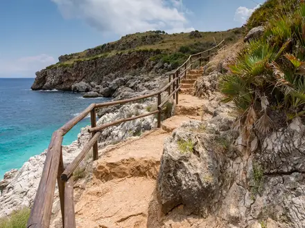
The trail is not technical, but it is fully exposed: no trees, almost no shade, strong wind risk and hot afternoon conditions in summer. The path undulates more than the low altitude suggests, with stone steps, gravel, packed earth and narrow ridgelines. Some edges have wooden guard rails; others are open drops. Water and toilets at Casa do Sardinha are seasonal, so carry what you need.
HikeList Score
Ponta de São Lourenço Trail scored 82/100 on HikeList's trail-quality metrics.
See score breakdownHide breakdown
- Ideal length 55
- Balanced challenge 100
- Scenery & wildness 85
- Varied terrain 89
- Accommodation 91
- Food & support 68
- Path quality 98
- Season flexibility 89
Computed from length, challenge, scenery & wildness, terrain variety, accommodation, food & support, path quality and season flexibility.
 Portugal
Show more data Show less
- Coastal
- Volcanic
- Exposed
- Stone Paved
- Steps
- Packed Earth
- Gravel
- Hotels
- Guesthouses
- Apartments
- Family Friendly
- Pet Friendly
- Restrooms
- Picnic Areas
Photos from hikers
Taken on the trail by people who've reviewed Ponta de São Lourenço Trail.
Reviews
How would you rate Ponta de São Lourenço Trail?
Tap a star to start your review — you could be the first.